Groundwater flood hazards and mechanisms in lowland karst terrains
←
→
Page content transcription
If your browser does not render page correctly, please read the page content below
Downloaded from http://sp.lyellcollection.org/ by guest on November 22, 2021

                  Groundwater flood hazards and mechanisms in
                            lowland karst terrains
OWEN NAUGHTON1,2*, TED MCCORMACK2, LAURENCE GILL1 & PAUL JOHNSTON1
1
 Department of Civil, Structural and Environmental Engineering, University of Dublin Trinity
                                      College, Ireland
          2
           Geological Survey Ireland, Beggars Bush, Haddington Road, Dublin, Ireland
                                      *Correspondence: naughto@tcd.ie

          Abstract: The spatial and temporal complexities of flooding in karst terrains pose unique chal-
          lenges in flood risk management. Lowland karst landscapes can be particularly susceptible to
          groundwater flooding due to a combination of low aquifer storage, high diffusivity and limited or
          absent surface drainage. Numerous notable groundwater flood events have been recorded in the
          Republic of Ireland throughout the twentieth century, but flooding during the winters of 2009
          and 2015 was the most severe on record, causing widespread and prolonged disruption and damage
          to property and infrastructure. Effective flood risk management requires an understanding of the
          recharge, storage and transport mechanisms governing water movement across the landscape during
          flood conditions. Using information gathered from recent events, the main hydrological and geo-
          morphological factors influencing flooding in these complex lowland karst groundwater systems
          are elucidated. Observed flood mechanisms included backwater flooding of sinks, high water levels
          in ephemerally flooded basins (turloughs), overtopping of depressions, and discharges from springs
          and resurgences. This paper addresses the need to improve our understanding of groundwater flood-
          ing in karst terrains to ensure efficient flood prevention and mitigation in the future, and thus helps to
          achieve the aims of the European Union Floods Directive.

          Gold Open Access: This article is published under the terms of the CC-BY 3.0 license.

Karst landscapes present a unique set of environmen-           within karst groundwater systems can rise dramati-
tal and engineering challenges to planners, stake-             cally during periods of intense or prolonged rainfall.
holders and the scientific community. Geohazards                As the subsurface storage and drainage reaches
such as subsidence, sinkholes, landslides, flooding             capacity, the rising water table can reach the topo-
and water contamination are common in karst envi-              graphic surface and produce floods (Gutiérrez et al.
ronments (Santo et al. 2007; Zhou 2007; Maréchal               2014; Naughton et al. 2017). However, unlike linear
et al. 2008; Worthington et al. 2012; Gutiérrez                flood features such as river channels or coastlines,
et al. 2014; Martinotti et al. 2017). Flooding and             the manifestation of groundwater flooding may be
flood risk management is a major challenge facing               discontinuous and determined by the spatially vari-
society in the coming decades, especially in the               able hydrodynamic properties and responses within
light of the increased frequency of extreme weather            the karst system. The surface expression of ground-
events as a result of climate change (Intergovern-             water flooding may only occur during extreme
mental Panel on Climate Change 2014). Effective                weather events and at relatively long recurrence
flood risk management requires an understanding                 intervals. Thus the flood frequencies traditionally
of the recharge, storage and transport mechanisms              used in flood risk assessment (such as 10 or 1%
in operation during flood conditions. In the context            annual exceedance probability) may be undefinable.
of groundwater flooding within karst systems, the               These inherent difficulties are explicitly acknowl-
heterogeneous and anisotropic nature of water-                 edged within the European Union Floods Directive
carrying fractures and conduits beneath the surface            2007/60/EC, whereby Member States are permitted
lead to obvious problems in developing such an                 to limit groundwater flood hazard maps to extreme
understanding (Field 1993).                                    event scenarios only.
    Karst terrains are uniquely susceptible to flooding             Groundwater flooding has not traditionally been
from groundwater sources due to a combination of               recognized as posing a significant risk and so
the low storage and high diffusivity characteristics           remains relatively less well understood than other
of these aquifers (Parise et al. 2015). Water levels           forms of flooding (Bonacci et al. 2006; Morris

From: PARISE, M., GABROVSEK, F., KAUFMANN, G. & RAVBAR, N. (eds) 2018. Advances in Karst Research:
Theory, Fieldwork and Applications. Geological Society, London, Special Publications, 466, 397–410.
First published online December 11, 2017, https://doi.org/10.1144/SP466.9
© 2018 Geological Survey of Ireland. Published by The Geological Society of London.
Publishing disclaimer: www.geolsoc.org.uk/pub_ethics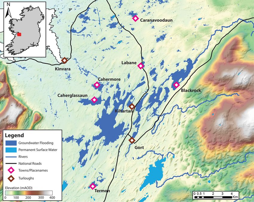
Downloaded from http://sp.lyellcollection.org/ by guest on November 22, 2021

398                                           O. NAUGHTON ET AL.

et al. 2007). Consequently, investigations into the         (10 ka to present) has also resulted in the develop-
contribution of karst hydrology to surface flooding          ment of a weathered epikarst zone near the bedrock
are still in their infancy (Gutiérrez et al. 2014).         surface, as well as active karst features, such as
This has begun to change in the last decade or so,          stream caves in the Burren (White 1988; Drew &
driven, in part, by the introduction of the European        Jones 2000; Drew 2008).
Union Floods Directive and its requirement to con-              The degree of karstification varies significantly
sider all forms of flooding, including groundwater,          across the country due to variabilities in the bedrock
but primarily due to a series of groundwater-related        purity, fracturing and landscape history. Karst fea-
flood events across Europe – in France (Pinault              tures are sparse or absent across much of the central
et al. 2005; Maréchal et al. 2008), Spain (Lopez-           and eastern limestones, where normal fluvial drain-
Chicano et al. 2002), the UK (Hughes et al. 2011;           age systems have developed with little interaction
Morris et al. 2015), Croatia (Bonacci et al. 2006)          with the underlying karst aquifer (Coxon 1986). By
and Italy (Parise 2003). Studies of polje hydrology         contrast, karst groundwater flow systems dominate
and flooding are perhaps the best described in               on the relatively pure, well-bedded lowland lime-
the literature.                                             stones in the west of the country (Fig. 1). These low-
    In the Republic of Ireland, the last decade has         lands experience a western maritime climate with a
seen the worst groundwater flooding in living mem-           long-term average annual rainfall (1981–2010) of
ory. The dramatic floods during the winters of 2009          c. 1100 mm (Walsh 2012). Recharge is principally
and 2015 caused widespread damage and disruption            autogenic in the form of direct (diffuse) and local
to communities across the country, particularly in the      point recharge; significant allogenic recharge is rela-
extensive karstic limestone lowlands on the western         tively uncommon (Drew 2008). One notable excep-
seaboard (Naughton et al. 2017). This paper presents        tion to this is the Gort Lowland catchment in south
a detailed example of the phenomenon of groundwa-           Galway, which receives the majority of catchment
ter flooding in the lowland karst terrains of western        recharge from the adjoining sandstone uplands
Ireland. Using examples and insights gained during          (Gill et al. 2013; McCormack et al. 2014).
the recent unprecedented flood events, we describe               Over 90% of Irish karst occurs in a low-lying
the main hydrological and geomorphological charac-          or lowland setting, typically 40% (30 000 km2) of the             in this hydrogeological setting, with frequent
surface or near-surface outcrop in the Republic of          reversals of the hydraulic gradients. The shallow
Ireland, making it the most prevalent bedrock               depth to groundwater limits the buffering effect of
type and primary regionally important aquifer lithol-       aquifer storage during recharge events. The lack of
ogy in the country (Simms 2004; Drew 2008). The             vadose zone storage is mitigated by the presence
main Irish limestones were formed during the Early          of a well-developed epikarst, where significant
Carboniferous or Dinantian (Drew et al. 1996)               weathering, fracturing and dissolution of the near-
when a marine transgression in the Tournaisian              surface bedrock provides additional storage. None-
period inundated much of the Old Red Sandstone              theless, ephemeral surface flooding from ground-
continent and provided the depositional environment         water sources is a prevalent feature of lowland
necessary for limestone formation (Guion et al.             karst terrains in Ireland.
2000; Sevastopulo & Wyse Jackson 2009). The tele-               During periods of high rainfall, excess recharge
genetic origin of Irish limestones has resulted in little   that cannot be accommodated by the subterranean
primary (matrix) porosity; instead, modern ground-          network of water-bearing fractures and conduits is
water circulation is dominated by secondary ( joints,       temporarily stored in ephemeral, geographically iso-
fractures and bedding planes) and tertiary (solution-       lated water bodies known as turloughs. Turloughs
ally widened) porosity. Irish limestones have under-        vary in size from ≤1 ha to >250 ha and more than
gone karstification many times since their formation,        400 active turloughs have been documented (Sheehy
with the most significant period being the Tertiary          Skeffington & Gormally 2007). Turloughs are usu-
(65–2 Ma) (Williams 1970; Drew 1990). Karst fea-            ally located along lines of concentrated flow within
tures have been documented in >80% of the lime-             an aquifer and thus play a key part in lowland karst
stone outcrop, indicating that karstification has            hydrology (Sheehy Skeffington et al. 2006); they
occurred across most, if not all, of the limestone for-     act as temporary storage for local and regional
mations in the country (Drew et al. 1996). More             recharge in a role akin to that of temporary bank
recent dissolution processes during the Holocene            and floodplain storage in fluvial systems (Naughton
Downloaded from http://sp.lyellcollection.org/ by guest on November 22, 2021

                        GROUNDWATER FLOODING IN LOWLAND KARST TERRAINS                                               399

Fig. 1. (a) Areas of Carboniferous limestone and distribution of turloughs in the Republic of Ireland (geological data
from the Geological Survey Ireland). (b) Location of groundwater flood hazard zones and site location map.

et al. 2017). Turlough flooding thus bears many sim-           damage and disruption to the surrounding areas. It
ilarities to that which occurs within poljes in karst, in     is in this context that turloughs represent the princi-
that both act as a subsystem of surface and ground-           pal form of recurrent, extensive groundwater flood-
water flow through the karst groundwater flow sys-              ing in Ireland. Historically, groundwater flooding
tem (Bonacci 2013). In fact, turloughs have been              has been centred on the karst limestone plains of
considered to be a subtype of the polje landform.             the western lowlands, principally in counties Ros-
Both karst depressions display complex hydrological           common, Mayo, Galway and Clare (Fig. 1). The
and hydrogeological characteristics, such as periodic         last decade has seen the worst groundwater flooding
inundation, temporary springs, lacustrine sediment            that the western limestone lowlands of Ireland have
deposition, swallow holes and estevelles. As with             experienced in living memory.
turloughs, the flooding within poljes can be severe
and pose a significant flood hazard to surrounding
properties and infrastructure (Mijatovic 1988; Kova-          Groundwater flood events of 2009–10
cic & Ravbar 2010).                                           and 2015–16
    During typical winter rainfall levels, flooding is
confined within the basin and acts as an environmen-           The winters of 2009–10 and 2015–16 were excep-
tal supporting condition for the wetland floral and            tionally wet seasons across the Republic of Ireland.
faunal species that have colonized the turlough hab-          Although both winters represent extreme meteoro-
itat (Sheehy Skeffington et al. 2006; Moran et al.             logical events, they differed in the intensity and
2008a; Porst et al. 2012). During extreme and/or              duration over which rainfall persisted. The heavy
prolonged rainfall, floodwaters within the basins              rainfall events of 2009 were caused by a series of
can reach extreme levels and cause widespread                 deep, fast-moving Atlantic depressions crossing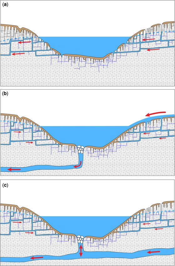
Downloaded from http://sp.lyellcollection.org/ by guest on November 22, 2021

400                                          O. NAUGHTON ET AL.

the country during November. Over twice the long-          region. The sustained nature of the flooding, lasting
term average amounts of rainfall were recorded at          for more than three months in some cases, caused
stations across Ireland, making November 2009              prolonged hardship to rural communities, who
the wettest on record (Walsh 2010; McCarthy                struggled to prevent the inundation of homes and
et al. 2016). By contrast, the winter of 2015–16           workplaces amid unparalleled disruption to trans-
saw more persistent wet weather. A succession of           port networks. The flooding of large tracts of agri-
storm fronts moved across Ireland from November            cultural land severely affected agricultural activity
to February, bringing with them exceptional rainfall       and posed a serious welfare risk to livestock,
accumulations across much of the country (McCar-           while anoxic soil conditions due to prolonged sub-
thy et al. 2016). Between December and February, a         mergence damaged hundreds of hectares of valuable
total of >600 mm (189% of the long-term average)           pasture land. An idea of the scale of flooding is
fell across the island of Ireland, making it the wet-      given in Figure 2, which shows the extent of floods
test winter on record in a rainfall time series stretch-   for south Co. Galway during the winter of 2015–16
ing back to 1850 (McCarthy et al. 2016; Noone              derived from field and satellite synthetic aperture
et al. 2016). December 2015 was also the wettest           radar measurements. This region is effectively
of any month on record in Ireland, with five stations       devoid of permanent surface water. The flooded
exceeding the previous Irish record for the highest        extents shown, encompassing an area >38 km2,
monthly rainfall total (McCarthy et al. 2016).             are primarily associated with flooding of the karstic
    The unprecedented rainfall events during the           groundwater system. Further widespread flooding
winters of 2009–10 and 2015–16 caused wide-                was also reported in counties Roscommon and
spread damage and disruption to residential houses,        Mayo, with more localized events in Clare, Long-
businesses, infrastructure and agriculture across the      ford and Westmeath.

Fig. 2. Groundwater flood extent map for 2015–16 flooding in the Gort Lowlands, Co. Galway, Ireland (derived
from field measurements and SAR imagery courtesy of Copernicus Emergency Management Service).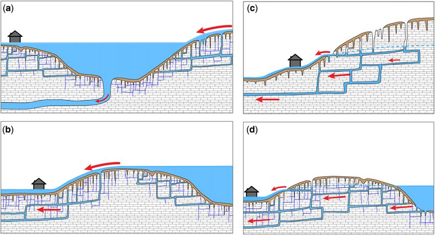
Downloaded from http://sp.lyellcollection.org/ by guest on November 22, 2021

                                          GROUNDWATER FLOODING IN LOWLAND KARST TERRAINS                              401

Groundwater flood response                                          between systems, reflecting heterogeneities in the
                                                                   extent of karstification, hydraulic connectivity and
Of these two exceptional winters, it was 2015–16                   aquifer storage. This variability gives rise to a spec-
which generally saw the highest groundwater levels                 trum of flooding regimes within turloughs, ranging
and most widespread flooding. Although some of                      from short duration flooding in basins with a rapid
the difference can be accounted for by regional                    response to rainfall events, to long duration flooding
variations in rainfall, the duration (or persistence)              in response to longer term precipitation patterns
of heavy rainfall was the primary cause. The crucial               (Naughton et al. 2012).
durations governing groundwater flooding can vary                       An example of the variability in water level
dramatically depending on the hydraulic properties                 response during flood conditions is demonstrated
and structure of the aquifer system, with response                 in Figure 4, which shows normalized water level
times ranging from minutes and hours up to multi-                  hydrographs (relative to their peak level) for three
annual timescales (Maréchal et al. 2008; De Waele                  turloughs in south Co. Galway during the 2009
et al. 2010; Hughes et al. 2011). In the case of                   flood event. Substantial differences are evident in
lowland karst groundwater flow systems in Ireland,                  hydrograph shape and the timing of peak flood
surface flooding is strongly related to the cumulative              levels, despite comparable inputs of rainfall. The
rainfall typically measured in weeks to months                     flood maximum in Blackrock turlough occurred on
(Moran et al. 2008b; Naughton et al. 2012). Figure 3               26 November 2009, about three weeks after the
shows the maximum rainfall depths for a range of                   onset of flooding within the basin. Over this period,
durations from the Irish Meteorological Service                    the floodwaters reached depths of up to 18 m, repre-
(Met Eireann) rainfall station in Gort, south Galway.              senting a flood volume of >15.6 × 10⁶ m3, which
Both winters showed rainfall totals significantly                   included a 2.9 × 10⁶ m3 increase over a single day.
above the median (1981–2010) for the area. For                     Blackrock turlough has an extensive allogenic
shorter durations (
Downloaded from http://sp.lyellcollection.org/ by guest on November 22, 2021
402 O. NAUGHTON ET AL.
Fig. 4. Rainfall record from Gort rainfall station and normalized water level hydrographs for Blackrock,
Caranavoodaun and Termon South turloughs, Co. Galway.
later in the flooding season, on 6 January 2010. data, aerial photography, satellite imagery, historical
The heavy rainfall of November 2009 contributed land maps, technical reports, local authority road clo-
significantly to the stored floodwaters within Ter- sure notices, local accounts and media sources. What
mon, but the slow drainage characteristics of the became apparent during the study was that although
underlying groundwater flow system meant that the primary form of extensive, recurrent ground-
peak levels occurred much later in the season after water flooding in Ireland originates in turloughs,
further rainfall. The flood maximum in Termon a range of mechanisms beyond simple turlough
turlough is thus a function of a rainfall duration flooding play a key part during extreme groundwater
measured in months rather than the weeks of Black- flood events.
rock turlough. From experience in the Chalk aquifers of south-
ern England, Robins & Finch (2012) proposed two
distinct types of groundwater flood event: ground-
Groundwater flooding mechanisms water flooding and groundwater-induced flooding.
The former is considered as a true groundwater
In response to the flooding in 2009 and 2015, we car- flood in which the water table rises above the ground
ried out a series of studies for key locations identified elevation, whereas a groundwater-induced flood
by the Office of Public Works and local authorities as occurs when intense groundwater discharge via
potentially affected by groundwater flooding. The springs and highly permeable shallow horizons dis-
objective was to assess the extent, nature and mech- charges to the surface water, causing overbank flood-
anisms of flooding, whether a significant flood risk ing (Robins & Finch 2012). A similar division is
existed and whether groundwater was the key con- proposed here for lowland karst groundwater sys-
tributor to that risk. Consistent long-term data on tems, wherein flood mechanisms can be broadly
groundwater flooding in Ireland do not exist and divided into those where the damage mechanism is
information was therefore derived from diverse primarily due to either hydrostatic action or hydrody-
sources, including field measurements, hydrometric namic action. The principal mechanisms identifiedDownloaded from http://sp.lyellcollection.org/ by guest on November 22, 2021
GROUNDWATER FLOODING IN LOWLAND KARST TERRAINS 403
Table 1. Groundwater flooding mechanisms in lowland karst groundwater systems in Ireland
Type Damage Description
Turlough flooding Hydrostatic Turlough floodwaters rise to extreme levels and pose a
flood risk to the surrounding area
Backwater flooding Hydrostatic Point recharge (sinking streams/rivers) exceeds the
groundwater drainage capacity, causing inundation of the
sink itself and backwater flooding upstream
Overtopping of sinks/ Hydrodynamic Ephemeral overland flow due to overtopping of flooded
basins depressions
Discharge from springs Hydrodynamic (a) Groundwater springs and risings at the periphery of
and resurgences upland areas exceed normal discharge levels, causing
flooding around and downstream of the resurgence
(b) Shallow lateral flow paths are activated within the
epikarst by high groundwater levels, triggering
ephemeral springs and flooding of
adjacent depressions
are given in Table 1 and Figure 5 and represent the Turlough flooding
type examples of how groundwater flooding mani-
fests in Irish lowland karst catchments. The main Turloughs represent the principal form of recurrent,
damage mechanism in turlough and backwater extensive groundwater flooding in Ireland. Dozens
flooding of sinks is by hydrostatic action, whereby of examples of flooding around turlough basins
elevated water levels with low or negligible water were identified across the western lowlands (e.g.
velocities pose a risk to surrounding receptors. Fig. 2). Although the numbers of receptors affected
Mechanisms where hydrodynamic action (flowing at any one site were relatively low, cumulatively tur-
water) posed a risk included ephemeral overland lough flooding caused extensive damage and disrup-
flow due to the overtopping of flooded depressions, tion to communities across the region. For example,
and excess discharge from permanent/transient Rahasane turlough, in the Dunkellin River catch-
springs and resurgences. ment, Co. Galway, flooded 12 houses along its
Fig. 5. Groundwater flood mechanisms in lowland karst groundwater flow systems: (a) turlough/backwater flooding
of sinks; (b) overtopping of basins and sinks; (c) discharge from spring and resurgences at the periphery of upland
areas; and (d) lateral flow through shallow epikarst pathways.Downloaded from http://sp.lyellcollection.org/ by guest on November 22, 2021
404 O. NAUGHTON ET AL.
banks during the November 2009 event. Flooding at direct transfer of water between them without first
Labane turlough, Co. Galway, forced the closure of passing through the main water body. The turlough
the N18 road between Galway City and Limerick basin effectively acts as a sink, receiving recharge
City for more than two months. Further north at from the surrounding vadose zone, shallow ground-
Lough Funshinagh, Co. Roscommon, floodwaters water systems and/or point recharge. In the case of a
in 2015–16 were the highest in living memory, cov- purely distributed through-flow system, drainage
ering an area of 4.6 km2 with a peak volume of >16 × occurs via a distributed network of shallow fractures
106 m3. Lough Funshinagh was notable due to the and conduits (Fig. 6a). Through-flow systems can
length of time the floodwaters persisted, with water also consist of point recharge and discharge
levels falling at a rate of only a few centimetres per (Fig. 6b), but groundwater flow within the system
week. Flood levels remained high throughout 2016 elements is unidirectional. In a surcharged tank
and were still above the previous record flood system (Fig. 6c), the main recharge and discharge
(from 2009 to 2010) a full six months after the peak. processes do not occur simultaneously. Instead, the
The nature of flooding, in terms of timing, extent water budget is controlled by a bidirectional flow
and duration, varied substantially, both locally and system located at or near the turlough base, with
regionally, in line with the spectrum of flooding the turlough acting as overflow storage for the under-
regimes and modus operandi characteristic of tur- lying conduit network. Under this scenario there is
loughs (Naughton et al. 2012). This may in some no significant discharge from the turlough during fill-
part be due to their polygenetic origins and the com- ing periods. During recession periods recharge is still
plex landscape history of Irish limestones. Turloughs derived from the local (proximal) shallow ground-
were originally considered as hollows in glacial drift water systems, but not from the distal catchment
with underlying karst drainage systems (Williams (Naughton et al. 2012).
1964). However, Drew (1973) asserted that tur- Understanding the nature of a turlough’s hydro-
loughs invariably lie in bedrock hollows and were logical budget is crucial if active flood management
solutional features requiring a far longer period to measures are to deliver the intended outcomes. For
develop than has passed since the last glaciation. example, the construction of surface drainage is
Coxon & Coxon (1994) suggested that turloughs often the first alleviation option considered after a
are polygenetic, with glacial deposition influencing flood event. A key element of drainage design is an
their morphology, but solutional rather than glacial estimate of the required channel conveyance capac-
processes being the determining factor in turlough ity. In the case of a through-flow system, a reason-
formation. The lines of high permeability associated able basis for such a calculation would be the net
with turloughs may thus represent the re-use of volume changes within the basin during a represen-
remnants of karst drainage systems created during tative flood season. However, this is not the case
Tertiary dissolution, but subsequently partially for a surcharged tank system. Artificially lowering
blocked by glacial drift, rather than post-glacial dis- the hydraulic head would increase the gradient into
solution pathways. Coxon & Drew (1986) suggested the basin, as the water budget is controlled by the
three models to explain turlough origin and the pres- head difference between the turlough and the under-
ence of the high permeability zones required for tur- lying groundwater system. The extra conveyance
lough formation: (1) glacial hollows with flow paths capacity provided by the channel would thus be at
developed post-glacially; (2) glacial hollows that least partially offset against increased recharge from
developed along the line of existing pre-glacial the distal catchment. Although the effective catch-
flow routes; and (3) pre-glacial karst features with ment area required to provide sufficient recharge to
associated flow paths modified by glaciation. flood a turlough basin may be relatively modest if
The hydrological budget of turloughs can be operating as a through-flow system, of the order of
described using two general conceptual models: a few square kilometres, the catchment from which
through-flow systems and surcharged tank systems floodwaters can potentially be derived can be orders
(Naughton et al. 2012). Rainfall onto, and evapora- of magnitude greater in surcharge tank systems. In
tion from, the water body is common across all mod- this case, the capacity of the drain/culvert may
els, as well as surface runoff from the surrounding need to be significantly greater than that in a through-
slopes. Surface evaporation is generally of minor flow turlough of comparable size.
importance to the water budget due to the seasonality The excavation and clearance of swallow holes is
of turlough flooding because it typically occurs dur- often cited as a potential solution to turlough flood-
ing the winter months. Direct precipitation and run- ing. Although this may improve drainage in some
off can be significant, particularly in shallow, flat circumstances, the drainage rate is often not limited
basins, but under flood conditions groundwater by localized constrictions at the inlet, but by the
flow is the dominant hydrological process. capacity of the underlying groundwater flow system.
In through-flow systems the recharge and dis- In the case of surcharged tank systems, any surface
charge processes work in partial isolation, with no modification of the estevelle is unlikely to reduceDownloaded from http://sp.lyellcollection.org/ by guest on November 22, 2021
GROUNDWATER FLOODING IN LOWLAND KARST TERRAINS 405
Fig. 6. Conceptual diagrams representing possible turlough water budgets: (a) distributed through-flow;
(b) through-flow with distributed/point recharge and point discharge; and (c) surcharged tank.
flooding because it serves as both the entry and exit flood attenuation devices within lowland karst
points for floodwaters. In through-flow systems the systems means that the reduction of flood risk in
rate of drainage is dependent on the flow capacity one turlough is likely to be at the expense of raising
and the relative hydraulic head within the turlough it in another, so a solid understanding of both site and
and receiving groundwater system. If this gradient catchment hydrodynamics is key.
is sufficiently small, as is often the case during
flood conditions, outflow may cease altogether and Backwater flooding of sinks
so any perceived improvement in drainage due to
swallow hole enlargement is unlikely to improve Backwater flooding occurs when excess point
the situation. Moreover, the role of turloughs as recharge (sinking streams or rivers) causes theDownloaded from http://sp.lyellcollection.org/ by guest on November 22, 2021
406 O. NAUGHTON ET AL.
inundation of dolines or sinks capable of accommo- (Fig. 5b). When overtopping occurs, ephemeral
dating recharge under normal conditions (Fig. 5a). overland flow routes develop, bypassing the ground-
This mode is analogous to the recharge-related sink- water flow systems normally governing water move-
hole flooding described by Zhou (2007), whereby ment through the catchment. It thus differs from
flooding occurs when the capacity of the sinkhole turlough and sink flooding in that the damage mech-
is not sufficient to transfer storm water runoff into anism is hydrodynamic and relates to floodwaters
the subsurface. The damage mechanism in back- moving across the landscape. This flood mechanism
water flooding is principally hydrostatic, but such bears some similarity to the karst flash floods
cases clearly have a strong fluvial component given described by Bonacci et al. (2006), whereby over-
their dependence on the discharge of the influent sur- land flow plays the dominant part in flood formation
face water. Backwater flooding is common across and inter-basin overflow and/or redistribution of the
the Irish karst lowlands, but in the clear majority of catchment areas occurs due to rising groundwater.
cases it is related to small autogenic streams with However, where flash flooding is typically in
low baseflow discharges and so does not pose a response to short (minutes to hours), high-intensity
significant flood risk. Historically, large-scale back- storms, the crucial recharge duration for the equiva-
water flooding in karst areas would have been rela- lent in lowland karst can be measured in weeks to
tively common. However, many areas formerly months. This is due to the significant surface storage
characterized by internal drainage have been sys- present within the gently undulating topography and
tematically modified by arterial drainage schemes low relief characteristic of the lowland landscape.
built during the late nineteenth and early twentieth The delayed build-up of waters makes this mech-
centuries (Drew & Coxon 1988). For example, the anism easier to foresee than flash flooding, but that is
1000 km2 Clare River catchment in north Co. Gal- not to say that it is easily preventable or managed.
way originally discharged underground via a series For example, a build-up of floodwaters around Kil-
of large sinks, turloughs and springs. Subsequent tartan, south Co. Galway in 2009 caused overtopping
construction and channelization of the Clare River of the N18 National Road with transient flow rates of
altered the natural karstic groundwater system and >30 m3 s−1 (Fig. 7), forcing the closure of the high-
it is surface water, rather than groundwater, that is way and a nearby railway line for more than two
now the controlling factor in present day flooding. weeks. Another example of overtopping occurred
One catchment where the karst system has during the floods of 2015–16 further west in the
remained effectively unmodified is in the Gort Low- Gort catchment at Caherglassaun turlough. Flooding
lands, south Co. Galway, and here backwater flood- within the turlough reached record depths of 14.6 m,
ing persists as a significant flood risk. The 500 km2 causing overland discharge of >5 m3 s−1 northwards
catchment is divided into sandstone uplands to the towards Cahermore, damaging properties along the
east and a lowland limestone plain to the west. Back- flow route and around Cahermore turlough.
water flooding occurs where point allogenic recharge
from the sandstone uplands, in the form of three Discharge from springs and resurgences
rivers, discharges onto the limestone lowlands and
sinks underground. The mean flows in the rivers Flooding in lowland karst aquifers can also be
range between 1.2 and 3 m3 s−1, but discharges can caused by high discharges of groundwater, via
reach >40 m3 s−1 during flood conditions, causing springs and resurgences, during which time the
widespread flooding upstream and inundating hun- hydrodynamic force of the floodwater is the main
dreds of hectares in the process (McCormack & cause of damage. This flood mechanism can be con-
Naughton 2016). Backwater flooding also occurs sidered as groundwater-induced, in that flooding
on the limestone plain due to the intermittent rising occurs due to intense groundwater discharge via
and sinking of discharges from the well-developed springs or shallow, highly permeable horizons
conduit network. Backwater flooding at one such within the epikarst (Robins & Finch 2012). In low-
sink in Kiltartan in 2009 incurred an estimated cost land karstic systems, a distinction can be made
of €540 000 to the local communities (Jennings between two discharge scenarios: (1) groundwater
O’Donovan & Partners 2011) and comparable dam- springs and risings on the periphery of upland
age was caused again during the winter of 2015–16. areas exceeding normal discharge levels and causing
flooding around and downstream of the resurgence
Overtopping of basins and sinks (Fig. 5c); and (2) shallow flow paths within the
epikarst zone are activated by high groundwater lev-
This flood mechanism is intrinsically linked to flood- els, triggering ephemeral springs and flooding of
ing within turlough and sink depressions because it adjacent depressions (Fig. 5d).
occurs when floodwaters build up in surface depres- The first scenario occurs where the lowland karst
sions to such an extent that the level exceeds landscape is characterized by flat and undulating
and overtops the surrounding topographic divide plains separated by isolated areas of higher ground,Downloaded from http://sp.lyellcollection.org/ by guest on November 22, 2021
GROUNDWATER FLOODING IN LOWLAND KARST TERRAINS 407
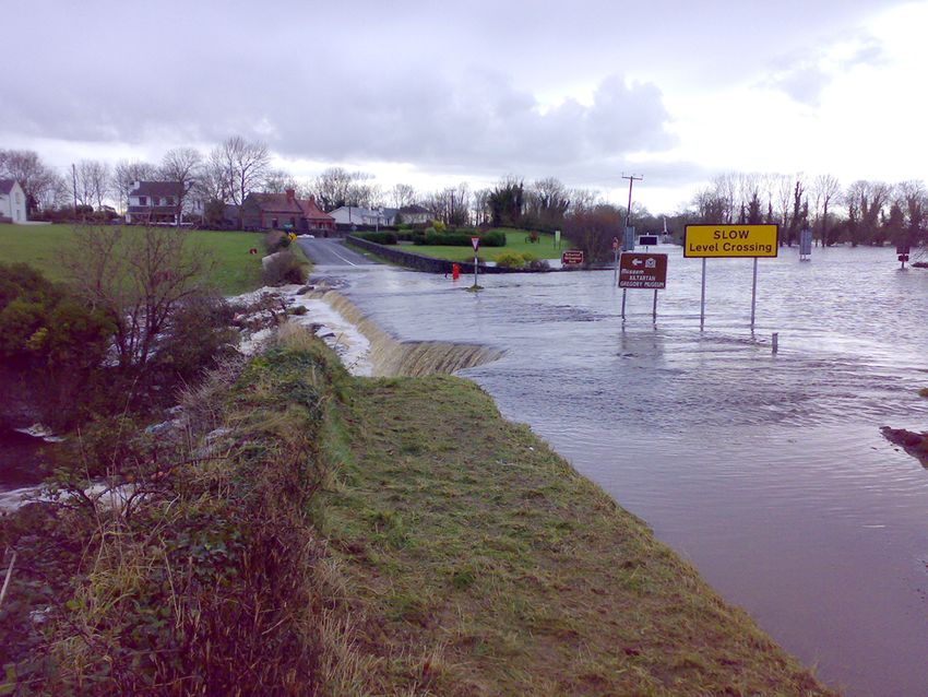
Fig. 7. Overflow across the N18 National Road, Kiltartan, Co. Galway (image provided by Galway County Council).
such as can be found in Co. Roscommon and north 2004). Under normal hydrological conditions this
Co. Galway. Here the recharge zones are located enhanced permeability plays an important part in
on topographic plateaus, which typically have thin regulating recharge to the phreatic zone by concen-
or absent subsoil, have a high density of recharge trating diffuse recharge towards areas of high vertical
landforms and a well-developed epikarst zone permeability. However, when phreatic groundwater
(Hickey 2010). Infiltration is transmitted through a levels rise sufficiently high, these pathways can
well-developed epikarst system to springs located transfer substantial lateral flows, giving rise to
at the periphery of the upland areas, where ground- ephemeral springs and seeps in adjacent topographic
water is discharged via a combination of perennial depressions previously unaffected by flooding. This
and/or overflow springs. During periods of intense mechanism contributed to the flooding in Carnmore,
recharge, discharge from these peripheral springs Co. Galway in November 2009, when a series of
can pose a significant flood risk. Excess spring dis- temporary springs activated in response to high
charge was the primary cause of groundwater flood- water levels in an adjacent turlough. Discharge
ing in Four Roads, Co. Galway, during November from epikarst springs caused the flooding of four
2009. Springs discharging from the base of an adja- houses, with a further seven houses and two business
cent karst plateau caused localized flooding around premises at high risk. There was also a significant
and downstream of the resurgence, inundating six hydrostatic element due to the ponding of spring dis-
houses and a community centre, as well as causing charge, further highlighting that flooding in lowland
the prolonged closure of roads and limiting access karst groundwater systems is often the result of mul-
to the local school. tiple mechanisms acting in combination.
The second scenario arises when elevated
groundwater levels cause significant lateral flow
through the uppermost weathered zone of the bed- Conclusions
rock, the epikarst. Karst aquifers can have substan-
tially enhanced and homogeneously distributed Lowland karst groundwater systems represent a
porosity and permeability in the epikarst (Klimchouk challenging environment from a flood riskDownloaded from http://sp.lyellcollection.org/ by guest on November 22, 2021
408 O. NAUGHTON ET AL.
management perspective. The diversity of flood BONACCI, O., LJUBENKOV, I. & ROJE-BONACCI, T. 2006.
mechanisms identified in lowland karst terrains rein- Karst flash floods: an example from the Dinaric karst
forces the need to develop a greater understanding (Croatia). Natural Hazards and Earth System Sciences,
of the complex hydrological and hydrogeological 6, 195–203.
COXON, C.E. 1986. A study of the hydrology and geomor-
processes in operation during flood conditions. phology of turloughs. PhD thesis, Trinity College
Although an important evidence base has been col- Dublin.
lated on groundwater flooding from recent extreme COXON, C.E. & COXON, P. 1994. Carbonate deposition in
events, significant gaps remain in our knowledge. turloughs (seasonal lakes) on the western limestone
The first and most pressing is the lack of hydro- lowlands of Ireland. II: The sedimentary record. Irish
logical data, which could be addressed through the Geography, 27, 28–35.
establishment of a permanent monitoring network COXON, C.E. & DREW, D.P. 1986. Groundwater flow in the
to provide long-term quantitative data at flood-prone lowland limestone aquifer of eastern Co. Galway and
locations. Methodologies for improving ground- eastern Co. Mayo western Ireland. In: PATERSON, K. &
SWEETING, M.M. (eds) New Directions in Karst. Geo
water flood hazard maps and real-time flood moni- Books, Norwich, 259–279.
toring are also required. A prerequisite to effective DE WAELE, J., MARTINA, M.L., SANNA, L., CABRAS, S. &
flood risk management and mapping is the ability COSSU, Q.A. 2010. Flash flood hydrology in karstic
to monitor spatial and temporal changes in flood terrain: Flumineddu Canyon, central-east Sardinia.
conditions and extent at a catchment scale. Tradi- Geomorphology, 120, 162–173.
tional field-based methods are heavily reliant on DIRECTIVE 2007/60/EC. 2007. Directive 2007/60/EC of
labour-intensive, site-specific visits and instrumenta- the European Parliament and of the Council of 23
tion. The increasing ability and availability of remote October 2007 on the assessment and management of
sensing data, such as synthetic aperture radar, offers flood risks. Official Journal of the European Union,
L288/27.
the potential to describe flood conditions quickly, DREW, D.P. 1973. Hydrogeology of the north Co. Galway &
accurately and at a large spatial scale, even over south Co. Mayo lowland karst area, western Ireland.
remote and rugged terrain. In: PANOS, V. (ed.) Proceedings of the 6th International
The floods of 2009–10 and 2015–16 have Congress of Speleology, Academic Press, Oloumec,
brought into focus society’s close, and often turbu- C57–C61.
lent, relationship with the water cycle in karst DREW, D. 1990. The hydrology of the Burren, Co. Clare.
areas. Internationally, there has been increasing rec- Irish Geography, 23, 69–89.
ognition of the flood mitigation benefits provided by DREW, D. 2008. Hydrogeology of lowland karst in Ireland.
functioning wetlands, nowhere more so than in the Quarterly Journal of Engineering Geology and Hydro-
geology, 41, 61–72, https://doi.org/10.1144/1470-
lowland karst landscapes of Ireland and the turloughs 9236/07-027
therein. However, the often-competing priorities of DREW, D.P. & COXON, C.E. 1988. The effects of land drain-
flood management and ecological conservation age on groundwater resources in karstic areas of
mean that inevitable conflicts lie ahead. An interdis- Ireland. In: YUAN, D. (ed.) Proceedings of the Interna-
ciplinary approach is thus crucial to enable commu- tional Association of Hydrogeologists 21st Congress
nities in lowland karst regions to develop the of Karst Hydrogeology and Karst Environment
adaptation and mitigation strategies needed in the Protection, 4. Geological Publishing House, Beijing,
face of future climate uncertainty. 204–209.
DREW, D. & JONES, G.L. 2000. Post-Carboniferous pre-
This work was carried out as part of the scientific project Quaternary karstification in Ireland. Proceedings of
GWFlood: Groundwater Flood Monitoring, Modelling the Geologists’ Association, 111, 345–353.
and Mapping, funded by the Geological Survey Ireland DREW, D., BURKE, A.M. & DALY, D. 1996. Assessing
and also represents outputs from research funded by the the extent and degree of karstification in Ireland. In:
Office of Public Works and the Irish Research Council. ROZKOWSKI, A., KOWALCZYK, A., MOTYKA, J. & RUBIN,
The authors thank the Irish Meteorological Service (Met K. (eds) International Conference on Karst Fractured
Eireann) for the provision of rainfall data, Galway County Aquifers – Vulnerability and Sustainability, June
Council for the provision of aerial photography and geo- 10–13 1996, Katowice-Ustron, Poland. Silesia Univer-
graphical information system data, and the Office of Public sity Press, Katowice, 37–47.
Works for the provision of LIDAR, hydrometric and aerial FIELD, M.S. 1993. Karst hydrology and chemical contami-
photography data. nation. Journal of Environmental Systems, 22, 1–26.
GILL, L.W., NAUGHTON, O., JOHNSTON, P.M., BASU, B. &
GHOSH, B. 2013. Characterisation of hydrogeologi-
cal connections in a lowland karst network using time
References series analysis of water levels in ephemeral groundwa-
ter-fed lakes (turloughs). Journal of Hydrology, 499,
BONACCI, O. 2013. Poljes, ponors and their catchments. 289–302, https://doi.org/10.1016/j.jhydrol.2013.07.002
In: SHRODER, J. (Editor-in-Chief) & FRUMKIN, A. (eds) GUION, P.D., GUTTERIDGE, P. & DAVIES, S.J. 2000. Carbon-
Karst Geomorphology, Treatise on Geomorphology, iferous sedimentation and volcanism on the Laurussian
6. Academic Press, San Diego, CA, 112–120. margin. In: WOODCOCK, N. & STRACHAN, R. (eds)Downloaded from http://sp.lyellcollection.org/ by guest on November 22, 2021
GROUNDWATER FLOODING IN LOWLAND KARST TERRAINS 409
Geological History of Britain and Ireland. Blackwell environmental impact of karst. Environmental Geology,
Science, Oxford, 227–270. 12, 117–121.
GUTIÉRREZ, F., PARISE, M., DE WAELE, J. & JOURDE, H. 2014. MORAN, J., SHEEHY SKEFFINGTON, M. & GORMALLY, M.
A review on natural and human-induced geohazards 2008a. The influence of hydrological regime and graz-
and impacts in karst. Earth-Science Reviews, 138, ing management on the plant communities of a karst
61–88. wetland (Skealoghan turlough) in Ireland. Applied
HICKEY, C. 2010. The use of multiple techniques for Vegetation Science, 11, 13–24.
conceptualisation of lowland karst, a case study from MORAN, J., KELLY, S., SHEEHY SKEFFINGTON, M. & GOR-
County Roscommon, Ireland. Acta Carsologica, 39, MALLY, M. 2008b. The use of GIS techniques to quan-
331–346. tify the hydrological regime of a karst wetland
HUGHES, A.G., VOUNAKI, T. ET AL. 2011. Flood risk from (Skealoghan turlough) in Ireland. Applied Vegetation
groundwater: examples from a Chalk catchment in Science, 11, 25–36.
southern England. Journal of Flood Risk Management, MORRIS, S.E., COBBY, D. & PARKES, A. 2007. Towards
4, 143–155. groundwater flood risk mapping. Quarterly Journal
INTERGOVERNMENTAL PANEL ON CLIMATE CHANGE 2014. of Engineering Geology and Hydrogeology, 40,
Summary for policymakers. In: Climate Change 203–211, https://doi.org/10.1144/1470-9236/05-035
2014 – Impacts, Adaptation and Vulnerability: Part MORRIS, S., COBBY, D., ZAIDMAN, M. & FISHER, K. 2015.
A: Global and Sectoral Aspects: Working Group II Modelling and mapping groundwater flooding at
Contribution to the IPCC Fifth Assessment Report. the ground surface in Chalk catchments. Journal of
Cambridge University Press, Cambridge, xv–xvi. Flood Risk Management, https://doi.org/10.1111/
JENNINGS O’DONOVAN & PARTNERS 2011. Engineering jfr3.12201
Proposals for the Reinstatement of Culverts on the NAUGHTON, O., JOHNSTON, P.M. & GILL, L. 2012. Ground-
N18 and the Provision of New Culverts on Minor water flooding in Irish karst: the hydrological charac-
Roads at Kiltartan/Feasibility of an Overland Channel terisation of ephemeral lakes (turloughs). Journal of
from Coole to Kinvarra. Office of Public Works, Hydrology, 470–471, 82–97.
Galway. NAUGHTON, O., JOHNSTON, P.M., MCCORMACK, T. & GILL,
KLIMCHOUK, A. 2004. Towards defining, delimiting and L.W. 2017. Groundwater flood risk mapping and
classifying epikarst: its origin, processes and variants management: examples from a lowland karst catchment
of geomorphic evolution. Speleogenesis and Evolution in Ireland. Journal of Flood Risk Management, 10,
of Karst Aquifers, 2, 1–13. 53–64.
KOVACIC, G. & RAVBAR, N. 2010. Extreme hydrological NOONE, S., MURPHY, C., COLL, J., MATTHEWS, T., MULLAN,
events in karst areas of Slovenia, the case of the D., WILBY, R.L. & WALSH, S. 2016. Homogenization
Unica River basin. Geodinamica Acta, 23, 89–100. and analysis of an expanded long-term monthly rainfall
LOPEZ-CHICANO, M., CALVACHE, M.L., MARTIN-ROSALES, W. network for the island of Ireland (1850–2010). Interna-
& GISBERT, J. 2002. Conditioning factors in flooding of tional Journal of Climatology, 36, 2837–2853.
karstic poljes – the case of the Zafarraya polje (south PARISE, M. 2003. Flood history in the karst environment of
Spain). Catena, 49, 331–352. Castellana-Grotte (Apulia, southern Italy). Natural
MARÉCHAL, J.-C., LADOUCHE, B. & DÖRFLIGER, N. 2008. Hazards and Earth System Science, 3, 593–604.
Karst flash flooding in a Mediterranean karst, the exam- PARISE, M., RAVBAR, N., ŽIVANOVIĆ , V., MIKSZEWSKI, A.,
ple of Fontaine de Nîmes. Engineering Geology, 99, KRESIC, N., MÁDL-SZŐ NYI, J. & KUKURIĆ , N. 2015.
138–146. Hazards in karst and managing water resources quality.
MARTINOTTI, M.E., PISANO, L. ET AL. 2017. Landslides, In: STEVANOVIĆ , Z. (ed.) Karst Aquifers – Characteriza-
floods and sinkholes in a karst environment: the 1–6 tion and Engineering. Professional Practice in Earth
September 2014 Gargano event, southern Italy. Natural Sciences. Springer, Berlin, 601–687.
Hazards and Earth System Sciences, 17, 467–480. PINAULT, J.L., AMRAOUI, N. & GOLAZ, C. 2005. Groundwa-
MCCARTHY, M., SPILLANE, S., WALSH, S. & KENDON, M. ter-induced flooding in macropore-dominated hydro-
2016. The meteorology of the exceptional winter of logical system in the context of climate changes.
2015/2016 across the UK and Ireland. Weather, 71, Water Resources Research, 41, W05001.
305–313. PORST, G., NAUGHTON, O., GILL, L., JOHNSTON, P. & IRVINE,
MCCORMACK, T. & NAUGHTON, O. 2016. Groundwater K. 2012. Adaptation, phenology and disturbance of
flooding in the Gort Lowlands. Groundwater Newslet- macroinvertebrates in temporary water bodies. Hydro-
ter, 53, 7–11. biologia, 696, 47–62.
MCCORMACK, T., GILL, L.W., NAUGHTON, O. & JOHNSTON, ROBINS, N. & FINCH, J. 2012. Groundwater flood or
P.M. 2014. Quantification of submarine/intertidal groundwater-induced flood? Quarterly Journal of
groundwater discharge and nutrient loading from a Engineering Geology and Hydrogeology, 45, 119–122,
lowland karst catchment. Journal of Hydrology, 519 https://doi.org/10.1144/1470-9236/10-040
(Part B), 2318–2330. SANTO, A., DEL PRETE, S., DI CRESCENZO, G. & ROTELLA, M.
MCCORMACK, T., NAUGHTON, O., JOHNSTON, P.M. & GILL, 2007. Karst processes and slope instability: some inves-
L.W. 2016. Quantifying the influence of surface tigations in the carbonate Apennine of Campania
water–groundwater interaction on nutrient flux in a (southern Italy). In: PARISE, M. & GUNN, J. (eds) Natural
lowland karst catchment. Hydrology and Earth System and Anthropogenic Hazards in Karst Areas: Recogni-
Sciences, 20, 2119–2133. tion, Analysis and Mitigation. Geological Society, Lon-
MIJATOVIC, B.F. 1988. Catastrophic flood in the polje of don, Special Publications, 279, 59–72, https://doi.org/
Cetinje in February 1986, a typical example of the 10.1144/SP279.6Downloaded from http://sp.lyellcollection.org/ by guest on November 22, 2021 410 O. NAUGHTON ET AL. SEVASTOPULO, G.D. & WYSE JACKSON, P.N. 2009. Carbonif- WALSH, S. 2012. A Summary of Climate Averages for erous: Mississippian (Tournasian and Visean). In: HEP- Ireland 1981–2010. Met Eireann, Dublin. WORTH HOLLAND, C. & SANDERS, I.S. (eds) The Geology WHITE, W.B. 1988. Geomorphology and Hydrology of of Ireland. Dunedin Academic Press, Edinburgh. Karst Terrains. Oxford University Press, Oxford. SHEEHY SKEFFINGTON, M. & GORMALLY, M. 2007. WILLIAMS, P.W. 1964. Aspects of the limestone physiogra- Turloughs: a mosaic of biodiversity and management phy of parts of counties Clare and Galway, Western systems unique to Ireland. Acta Carsologica, 36, Ireland. PhD thesis, University of Cambridge. 217–222. WILLIAMS, P.W. 1970. Limestone morphology in Ireland. SHEEHY SKEFFINGTON, M., MORAN, J., O CONNOR, A., REGAN, In: STEPHENS, N. & GLASSCOCK, R.E. (eds) Irish E., COXON, C.E., SCOTT, N.E. & GORMALLY, M. 2006. Geographical Studies. Queen’s University, Belfast, Turloughs – Ireland’s unique wetland habitat. Biologi- 105–124. cal Conservation, 133, 265–290. WORTHINGTON, S.R., SMART, C.C. & RULAND, W. 2012. SIMMS, M.J. 2004. Tortoises and hares: dissolution, erosion Effective porosity of a carbonate aquifer with bacterial and isotasy in landscape evolution. Earth Surface contamination: Walkerton, Ontario, Canada. Journal of Processes and Landforms, 29, 447–494. Hydrology, 464, 517–527. WALSH, S. 2010. Report on Rainfall of November 2009. ZHOU, W. 2007. Drainage and flooding in karst terrains. Met Eireann, Dublin. Environmental Geology, 51, 963–973.
You can also read