Guidance for Managing Sea Level Rise Infrastructure Risk - in Pacific Island Countries
←
→
Page content transcription
If your browser does not render page correctly, please read the page content below
Guidance for Managing
Sea Level Rise
Infrastructure Risk
in Pacific Island Countries
This report is published by the Pacific Region Infrastructure Facility (PRIF).

PRIF is a multi-development partner coordination and technical assistance facility that supports infrastructure
development in the Pacific. PRIF member agencies include the Asian Development Bank, Australian Department
of Foreign Affairs and Trade, European Investment Bank, European Union, Japan International Cooperation
Agency, New Zealand Ministry of Foreign Affairs and Trade, United States Department of State, and the World
Bank Group.

The views expressed in this report are those of the authors and do not necessarily reflect the views and policies
of ADB, its Board of Governors, the governments they represent, or any of the other PRIF member agencies.
Furthermore, the above parties neither guarantee the accuracy of the data included in this publication, nor
do they accept responsibility for any consequence of their application. The use of information contained in
this report is encouraged, with appropriate acknowledgement. The report may only be reproduced with the
permission of the PRIF Coordination Office on behalf of its members.

Acknowledgements
This report draws on specialist reports published by IPCC (2021) Climate Change 2021: The Physical Science
Basis. Contribution of Working Group I to the Sixth Assessment Report of the Intergovernmental Panel on
Climate Change, IPCC (2019) Ocean and Cryosphere in a Changing Climate, MfE (2017) Coastal Hazards and Climate
Change and the Pacific-Australia Climate Change Science and Adaptation Planning Program, 2014 Climate
Variability, Extremes and Change in the Western Tropical Pacific: New Science and Updated Country Reports.

The report has been prepared by Connon Andrews, under the guidance of Roger Guinery, Infrastructure
Economist, PRIF Coordination Office.

The Asian Development Bank provided administrative support. The author thanks the PRIF project team,
members of the PRIF committees and working groups, external technical reviewer Anthony Kiem and editors.

More information and copies of this review can be obtained from:
PRIF Coordination Office
c/o Asian Development Bank
Level 20, 45 Clarence Street
Sydney, NSW 2000, Australia
Phone: +61 2 8270 9444
Email:   enquiries@theprif.org
Website: www.theprif.org

Published February 2022
Reference to guidance content including tables and figures should be referenced as:
PRIF (2021): Guidance for Managing Sea Level Rise Infrastructure Risk in Pacific Island Countries, Published: December 2021.
Cover images: Salesa Nihmei

            Guidance for Managing Sea Level Rise Infrastructure Risk in Pacific Island Countries | Page 2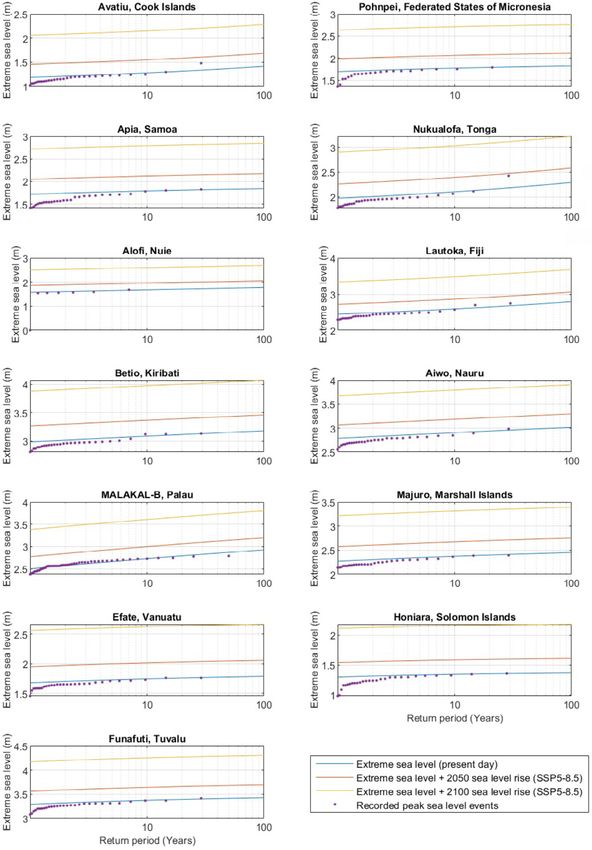
Contents
Executive Summary		                                                                                     6

1    Introduction		                                                                                     7
     1.1   Why is Guidance Required?                                                                    7
     1.2   About this Guidance Note                                                                     8
     1.3   Geographic Coverage                                                                          9

2    Planning for Sea Level Rise                                                                        10
     2.1   Adjacent Sea Level Rise Impacts                                                              12
     2.2   Adaptative Planning                                                                          13
     2.3   Development of Adaptative Infrastructure Plans                                               15
		         2.3.1     Step 1 - Mobilize the Community, Understand Context and Scope of Risk              15
		         2.3.2     Step 2 - Reveal Risk, Assess Sea Level Rise, and Coastal Hazard Risk               17
		         2.3.3     Step 3 - Rethink Futures and Develop Adaptative Pathways                           18
		         2.3.4     Step 4 – Navigate Change, Implement and Monitor                                    19
		         2.3.5     Summary                                                                            19

3    Future Sea Level Rise Projections                                                                  22
     3.1   Climate Scenarios                                                                            22
     3.2   Global Sea Level Rise Projections                                                            23
     3.3   Pacific Sea Level Rise Projections                                                           26
     3.4   Cook Islands                                                                                 27
     3.5   Federated States of Micronesia                                                               28
     3.6   Samoa		                                                                                      29
     3.7   Tonga		                                                                                      30
     3.8   Niue		                                                                                       31
     3.9   Fiji		                                                                                       32
     3.10 Kiribati		                                                                                    33
     3.11 Nauru		                                                                                       34
     3.12 Palau		                                                                                       35
     3.13 Republic of the Marshall Islands                                                              36
     3.14 Vanuatu		                                                                                     37
     3.15 Solomon Islands                                                                               38
     3.16 Tuvalu		                                                                                      39

        Guidance for Managing Sea Level Rise Infrastructure Risk in Pacific Island Countries | Page 3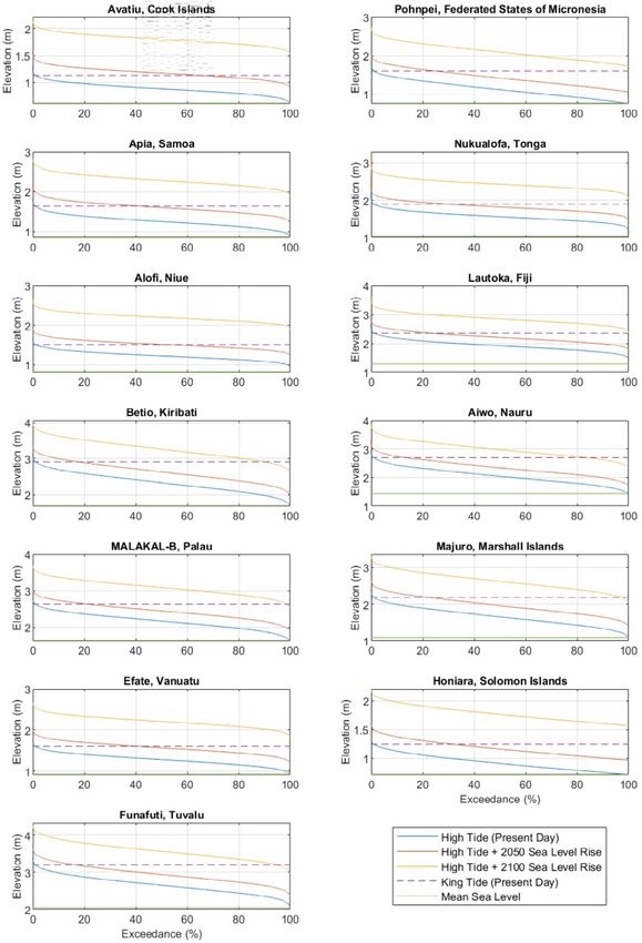
4     Application of Sea Level Rise Projections                                                         40

      4.1   Infrastructure Planning                                                                     41

      4.2   Engineering Design                                                                          41

5     Sea Level Variability and Future Risk                                                             42

      5.1   Components of Sea Level                                                                     44

      5.2   Short-Term Mean Sea Level Variability                                                       44
      5.3   Long-Term Mean Sea Level Variability                                                        46
      5.4   Future Sea Level Exposure                                                                   49
		          5.4.1     Permanent Change                                                                  49
		          5.4.2     Rare Events                                                                       51
      5.5   Wave Climate                                                                                53
		          5.5.1     Ambient Wave Climate                                                              54
		          5.5.2     Extreme Wave Climate                                                              54
      5.6   Assessing Vulnerability                                                                     54

		          5.6.1     Case Study – Initial Sea Level Rise Risk Assessment for Nauru                     56

6     Recommendations to Assist Future Sea Level Risk Assessment                                        59
      6.1   Data Consolidation and Update                                                               59
      6.2   Investigations                                                                              59
      6.3   PIC Risk Assessment                                                                         60

References			                                                                                           61

Appendix 1: Key Resources                                                                               64

        Guidance for Managing Sea Level Rise Infrastructure Risk in Pacific Island Countries | Page 4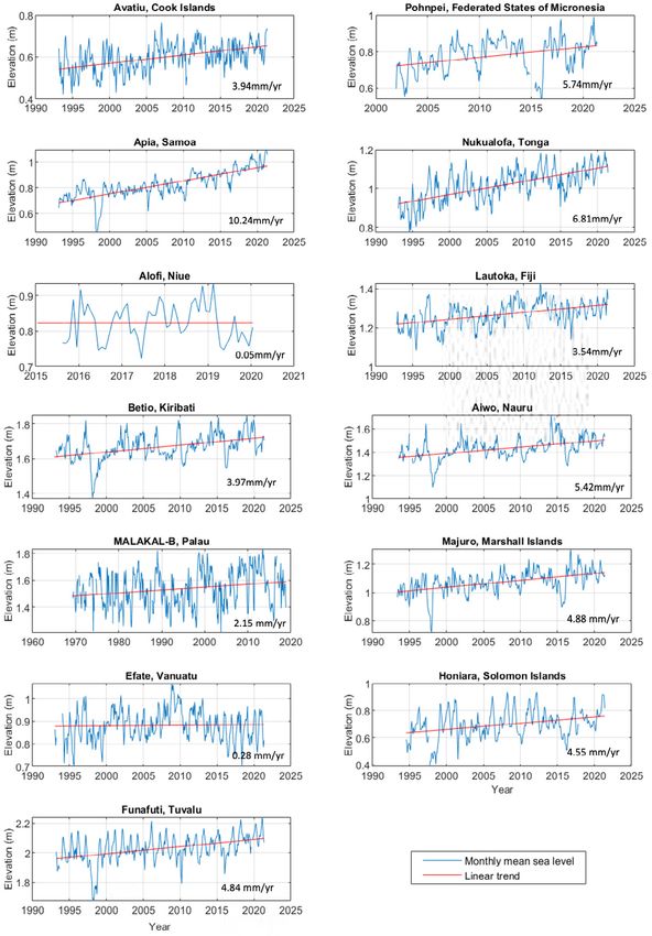
Abbreviations
ADB			         Asian Development Bank
APCP 		        Australian Pacific Climate Partnership
AR5			         IPCC 5th Assessment Report
AR6			         IPCC 6th Assessment Report
CD			          Chart Datum
CMIP6          Coupled Model Intercomparison Project Phase 6
CSIRO		        Commonwealth Scientific and Industrial Research Organization
ENSO           El Niño Southern Oscillation
FSM			         Federated States of Micronesia
GIS			         Geographic Information System
GNSS		         Global Navigation Satellite System
IPCC 		        Intergovernmental Panel on Climate Change
IOC 		         Intergovernmental Oceanographic Commission
IPO			         Interdecadal Pacific Oscillation
LIDAR          Light Detection and Ranging
MfE		          Ministry for the Environment – New Zealand
NAP			         National Adaptation Plan
NDC			         Nationally Determined Contribution
NID			         Nauru Local Datum
NIWA		         National Institute of Water and Atmospheric Research - New Zealand
PACCSAP        Pacific-Australia Climate Change Science and Adaptation Programme
PIC			         Pacific Island Country
PRIF			        Pacific Region Infrastructure Facility
RCP			         Representative Concentration Pathway
RMI			         Republic of the Marshall Islands
SOPAC		        South Pacific Applied Geoscience Commission
SPC			         Secretariat of the Pacific Community
SPCZ			        South Pacific Convergence Zone
SPREP		        Secretariat of the Pacific Regional Environment Programme
SSP			         Shared Socioeconomic Pathways
UNESCO         United National Educational, Scientific and Cultural Organization
WACOP          Changing Waves and Coasts in the Pacific

          Guidance for Managing Sea Level Rise Infrastructure Risk in Pacific Island Countries | Page 5
Executive Summary
Sea level rise, which is experienced throughout the Pacific, is adversely affecting infrastructure and,
consequently, communities. Combined with ongoing intensification of coastal development and future
projections of higher rates of sea level rise for Pacific Islands Countries (PICs), the risk and liability exposure
are increasing.

Near-term sea level projections to 2050, which are mostly a result of past emissions, indicate a global rise
of 0.19–0.24m.1 The increase is projected to change the permanent exposure of PIC coastal margins and
significantly increase vulnerability to extreme events. Post-2050 exposure continues to increase as a function
of sea level rise, which is dependent on emission decisions by the global community. By 2150, sea levels could be
as high as 0.68–1.98m and up to 5.0m should ice shelves break up faster than expected.

Many of the low-lying regions within PICs are likely to exceed adaptation limits from sea level rise well before the
end of this century, even in a low greenhouse gas emission pathway. Regardless of the effectiveness of mitigation
and adaptation pathways, under all future emission scenarios most of the low-lying regions may face adaptation
limits beyond 2100.2

In recognition of the pressure on infrastructure in the coastal margins from sea level rise, strategic long-
term planning is required to ensure that risk is managed. Long-term planning in PICs needs to reconcile the
uncertainty associated with future climate change with variability in social, cultural, economic, environmental
values and capacity to cope.

Effective long-term management of infrastructure, which is ultimately a function of community needs, goals,
and aspirations, is based on robust controls on the quality of construction and, importantly, where infrastructure
should, or should not, be developed. Throughout PICs, there is limited or inconsistent guidance on these
controls.

To assist PIC planners and decision makers, guidance for dynamic adaptative management plans for critical
infrastructure and communities is provided, with the outcome being operational infrastructure plans that are
sensitive to climate change triggers, and with clear and pre-agreed short-term actions and long-term pathways
defined to manage risk.

In recognition that the adaptative management journey is often protracted due to the complexity of issues,
transitional guidance to manage risk based on fixed values of sea level rise and projections is provided. The
transitional guidance, which is based on a balanced risk profile built around the IPCC 6th Assessment Report
(AR6) sea level rise projections, is designed to support or be integrated into the longer-term land use plans or
alternatively PIC codes and standards.3

PICs have a low adaptative capacity to climate change, and a holistic approach to infrastructure management
that considers the full range of plausible climate change and natural hazard outcomes is required. PICs are
encouraged to start the adaptative management process by engaging with the community as a vehicle to
educate and gain community buy-in to potential adaptative pathways and align aspirations with wider multi-
development partner programs.

Due to the rate of sea level rise, high near-term infrastructure exposure and limited adaptative capacity, urgent
adaptative planning and engineering design controls are required for each PIC to manage future risk.

1
  I PCC. 2021. Climate Change 2021: The Physical Science Basis. Contribution of Working Group I to the Sixth Assessment Report of the Intergovernmental Panel on
   Climate Change, edited by V. Masson-Delmotte, et al. Cambridge: Cambridge University Press (in press).
2
   IPCC. 2019. IPCC Special Report on the Ocean and Cryosphere in a Changing Climate, edited by H.-O. Pörtner, et al. Geneva: IPCC.
3
   IPCC. 2021. Climate Change 2021.

              Guidance for Managing Sea Level Rise Infrastructure Risk in Pacific Island Countries | Page 6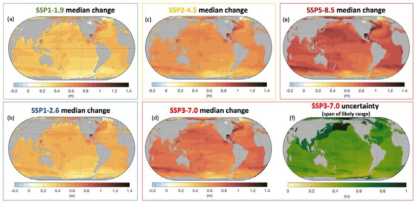
1. Introduction
Climate change is impacting low-lying Pacific islands, with cascading and compounding risks that are expected
to increase throughout the 21st century and beyond. Vulnerable communities, especially in Pacific coral reef
environments, may exceed adaptation limits well before the end of this century, even in a low greenhouse
emission pathway.4 Regardless of the effectiveness of mitigation and adaptation pathways, under all future
emission scenarios, most of the low-lying regions may face adaptation limits beyond 2100.

Future rates of global sea level rise are strongly dependent on decisions by the global community. Climate
projections show that the rate of sea level rise at the end of the century is expected to be faster under all
possible scenarios, including those compatible with achieving the long term temperature goal set out in the
Paris Agreement.5 By 2100, the global mean sea level is projected to rise by 0.28m to 1.02m with a higher
likelihood towards the upper end of the range based on current Nationally Determined Contribution (NDC)
targets which is currently tracking to a world that is 2.4 °C to 2.7 °C warmer above preindustrial levels.6

1.1 Why is Guidance Required?
Hazard risk from sea level rise is compounding in coastal areas because impacts are occurring more frequently
as seas rise, while, at the same time, coastal development intensifies. Sea level is expected to keep rising for at
least several centuries, posing an ongoing challenge for Pacific Island Countries (PICs) to maintain sustainable
coastal communities.7

Sea-level-rise-induced hazards impact on a wide range of social, cultural, and economic values, as well as
affecting the natural and physical environment. Acceptable solutions for adapting to the changes vary from place
to place, and for some communities will be made more complex by greater risks, greater vulnerability, and a
lower ability to cope. There is no one-size-fits-all solution. PIC national and local governments face the enduring
question of how to achieve the aspirations of local communities while making sometimes unpopular decisions
that will enable them to adapt to a changing climate.

The rate of current sea level rise and the wide range of scenarios for future sea levels presents a challenge
when considering new and existing critical infrastructure. Effective risk management requires controls on
where infrastructure is developed or currently maintained while considering the increased hazards from climate
change. Internationally, this is commonly achieved through integrated Building Acts and national adaptation and
natural hazard strategies and plans. However, most PICs have limited or non-existent development controls and
plans/legislation to support long-term risk management.

For new development, sea level rise risk is commonly addressed via engineering design codes and standards
and are based on fixed values of projected sea level rise as a function of design life. Consideration of sea level
rise is restricted to the individual asset, making the application of codes and standards alone insufficient to
manage infrastructure regionally. Due to the uncertainty of climate change, and level of direction contained
within existing codes and standards there is high variability in the application of sea level rise projections and
magnitudes of sea level rise throughout PICs.

The combination of limited long-term land use planning in conjunction with inconsistent application of sea
level rise projections and magnitudes provides the opportunity to accept unintended risk or, alternatively,
overestimate risk, resulting in overdesigned infrastructure. In recognition of the limitations, revised sea level
rise projections and guidance to manage infrastructure risk are proposed.

4
  IPCC. 2019. IPCC Special Report on the Ocean and Cryosphere.
5
  Ibid. The Paris Agreement has a goal is to limit global warming to well below 2 °C, preferably 1.5 °C compared to preindustrial levels. To achieve this long-term
   temperature goal, countries aim to reach global peaking of greenhouse gas emissions as soon as possible to achieve a climate-neutral world by 2050. Recent analysis
   completed for the 6th Assessment Report has concluded that a more aggressive Very low emissions (SSP1–1.9) pathway is required, which is well below the current
   global NDC to limit global temperature increase to 1.5 °C above preindustrial levels.
6
   IPCC. 2021. Climate Change 2021.
7
   Ibid.

              Guidance for Managing Sea Level Rise Infrastructure Risk in Pacific Island Countries | Page 7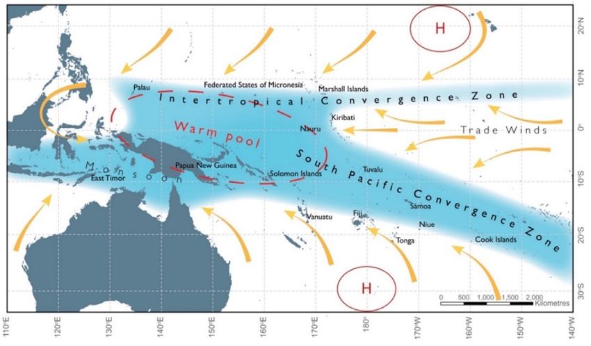
1.2 About this Guidance Note
Sea level rise in combination with extreme sea level events (e.g., storm surges) and non-climate drivers such
as subsidence are increasing PIC community and infrastructure vulnerability and exposure. The associated
risk from sea level rise is dynamic and varies widely due to the localized nature of inundation, scale of coastal
infrastructure, community livelihoods, and habitability.

Section 2 of this guidance note summarizes the approach to sea level rise planning and includes potential
generic responses when considering infrastructure development. The concept of dynamic adaptive pathways is
introduced, and a framework is proposed to help manage sea level risk.

The IPCC 6th Assessment Report (AR6) has introduced a new set of climate scenarios and projections that differ
from prior assessments. To assist infrastructure practitioners and decision makers, projections of sea level rise
for each PIC have been compiled based on the latest AR6 analysis and presented in Section 3. The projections
incorporate statistical long-term vertical land movement rates and have been extended to provide decadal
estimates to the year 2150.

In lieu of finalized adaptation plans, transitional guidance is provided based on fixed levels of sea level rise and/or
selected projections for various infrastructure types. The guidance is intended to complement existing planning
processes and design codes or standards to provide immediate direction in defining acceptable level of risk.
Recommended minimum projections of sea level rise for infrastructure planning and development are provided
in Section 4.

There are several components that make up sea level with varying magnitudes under ambient and extreme
conditions. To support local definition of sea level rise hazard, Section 5 presents a summary of each component
based on recorded tide gauge data for each PIC. Trends of past sea level rise are presented in association with
observed vertical land movement. Considering near-term estimates of sea level rise, changes to exposure of the
coastal margin is quantified for both ambient and extreme conditions. Links to key resources to support sea level
assessments are provided in Appendix 1.

Recommendations to progress sea level rise infrastructure risk assessment and future planning are provided in
Section 6 with an emphasis on data gap filling and progressing adaptation planning.

This guidance note has retained the language and terminology that is used by the IPCC to ensure that the
guidance outcomes are transferable. Critical terms shown in italics include the following:
      •     ost likely is defined as the range of outcomes that are bounded by the 5th and 95th percentiles of the
           M
           relevant variable representing a probability of occurrence of 90%.
      •    L ikely is defined as the range of outcomes that are bounded by the 17th and 83rd percentiles of the
            relevant variable representing a probability of occurrence of 66%. The likely values are presented in
            brackets, e.g., (0.05–0.20).
      •    High confidence: based on robust evidence and high agreement.
      •    Medium confidence: based on medium evidence and medium agreement.
      •    Low confidence: based on limited evidence and low agreement.

This guidance does not intend to replace codes, standards, or guidance manuals that are in existence. The
guidance has been developed to assist infrastructure planners and developers in understanding the quantum
of the future sea level rise and how it should be considered when developing new or managing existing
infrastructure in lieu of established guidance. For aspects of the guidance that require specialist assessment, it is
recommended that a suitably qualified professional be utilized.

          Guidance for Managing Sea Level Rise Infrastructure Risk in Pacific Island Countries | Page 8
1.3 Geographic Coverage
The geographic extent of the guidance is confined to the Cook Islands, Federated States of Micronesia (FSM),
Samoa, Tonga, Fiji, Kiribati, Nauru, Palau, Republic of the Marshall Islands (RMI), Niue, Tuvalu, Solomon Islands,
and Vanuatu. Locations with reference to dominant Pacific climate processes that influence global climate
change effects for the region are presented in Figure 1.1.

Infrastructure throughout these locations is particularly susceptible to the impacts from natural variability
of regional climate processes from year to year and season to season and have significant effect on the
environment and communities. These large-scale climate processes include El Niño Southern Oscillation (ENSO),
the South Pacific Convergence Zone (SPCZ), the West Pacific Monsoon, and the Intertropical Convergence
Zone, and the zone of influence is presented in Figure 1.1. Longer-term climate change and variability compound
these processes, which, in turn, increases vulnerability to natural climate disasters.

Figure 1.1: Weather and Climate Processes that Influence PICs between November and April

Notes:
1. Pacific Island Country (PIC).
2. Yellow arrows indicate near surface winds.
3. R
    ed dashed region indicates the typical location of the Pacific Warm Pool (i.e., during years classed as the Neutral phase of
   the El Niño/Southern Oscillation).
4. High pressure systems are indicated by H.
Source: Australian Bureau of Meteorology and CSIRO. 2014. Climate Variability, Extremes and Change in the Western
Tropical Pacific: New Science and Updated Country Reports. Pacific-Australia Climate Change Science and Adaptation
Planning Program Technical Report, Australian Bureau of Meteorology and Commonwealth Scientific and Industrial Research
Organization, Melbourne, Australia.

           Guidance for Managing Sea Level Rise Infrastructure Risk in Pacific Island Countries | Page 9
2. Planning for Sea Level Rise
When developing or managing infrastructure, decision makers are required to consider the range of hazards
that infrastructure is subject to, the exposure and vulnerability, and the inherent uncertainty associated with
sea level rise. The range of hazards from sea level can be diverse (Table 2.1) and depend on infrastructure type,
design, and location.

Because of climate uncertainty, it is necessary to consider a range of plausible future states. Since planning of
greenfield development or new infrastructure will lock in a level of risk, consideration of management options to
address future sea level rise, and wider climate change variables is required.

The principles of managed risk and “no regrets”, or precautionary decision making, are common throughout
PICs when considering major new development. However, when considering sea level rise and wider climate
change impacts, the scale of the potential impact makes the decision-making framework complex, with potential
consequences persisting well into the future and potentially compounding risk.

Beyond mitigation, adaptation is a key avenue to reducing risk (Figure 2.1). Adaptation efforts can reduce
existing and future vulnerability, exposure, and, where possible, hazards. Addressing the different risk
components (hazards, exposure, and vulnerability) involves assessing and selecting options for policy and action.
Such decision-making entails evaluation of the effectiveness, efficiency, efficacy, and acceptance of actions.
Adaptation requires capacity, which is particularly challenging in PICs, due to limited available land, complex land
ownership and economic funds to commit to a particular strategy.
                                           Figure 2.1: Components of Risk

Source: IPCC, 2019: IPCC Special Report on the Ocean and Cryosphere in a Changing Climate.

Throughout PICs, National Adaptation Plans (NAPs) have been, or are being, developed, albeit at a high level
that considers generic adaptation responses to sea level rise, as presented in Box 2.1. However, considering
adaptative capacity, most PICs have yet to define the risk and develop long-term land use and adaptation plans
at a national or community (local) level to manage sea level rise risk. Furthermore, for project development there
remains a wide range of codes and standards throughout PICs that provide inconsistent or limited guidance on
sea level rise risk and magnitude with respect to asset design life.

          Guidance for Managing Sea Level Rise Infrastructure Risk in Pacific Island Countries | Page 10
Box 2.1: Responses to Sea Level Rise
Advance creates new land by building seaward, reducing coastal risks for the hinterland and the newly
elevated land. This includes land reclamation above sea levels, planting vegetation with the specific
intention to support natural accretion of land and surrounding low areas with stop banks/dikes. Advance
also requires drainage and often pumping systems to address increased catchment-based flooding.
Protection reduces coastal risk and impacts by blocking the inland propagation and other effects of mean
or extreme sea levels. This includes: i) hard protection such as dikes, seawalls, breakwaters, barriers, and
barrages to protect against flooding, erosion, and saltwater intrusion; ii) soft protection such as beach
and shore nourishment, dunes; and iii) ecosystem-based adaptation (see below). The three subcategories
are often applied in combination as hybrid measures.
Retreat reduces coastal risk by moving exposed people, assets, and human activities out of the coastal
hazard zone. This includes the following three forms: i) Migration, which is the voluntary permanent or
semi-permanent movement of people; ii) Displacement, which refers to the involuntary and unforeseen
movement of people due to environment related impacts; and iii) Relocation, also termed resettlement,
managed retreat, which is typically initiated, supervised, and implemented by governments from national
to local levels and usually involves small sites and/or communities. The need for retreat and other
response measures can be reduced by avoiding new development commitments in areas prone to severe
sea level rise hazards.
Accommodation includes diverse biophysical and institutional responses that mitigate coastal risk and
impacts by reducing the vulnerability to coastal residents, human activities, ecosystems, and the built
environment, thus enabling the habitability of coastal zones despite increasing levels of hazard occurrence.
Accommodation measures for erosion and flooding include building codes, land use planning, raising
infrastructure, and designing infrastructure so that it can be modified in the future to reduce risk.
Ecosystem-based Adaptation combines Protection and Advance benefits based on the sustainable
management, conservation, and restoration of ecosystems. Examples include the conservation or
restoration of coastal ecosystems such as wetlands and reefs. Ecosystem-based adaptation protects
the coastline by (i) attenuating waves, and, in the case of wetlands storm surge flows, acting as obstacles
and providing retention space; and (ii) raising elevation and reducing rates of erosion through trapping
and stabilizing coastal sediments, as well as building up of organic matter and detritus. Ecosystem-based
adaptation is also referred to by various other names, including Natural and Nature-based Features,
Nature-based Solutions, Ecological Engineering, Ecosystem-based Disaster Risk Reduction or Green
Infrastructure. Within Pacific Island countries, common forms of Ecosystem-based Adaptation that
feature in many of the National Adaptation Plans include mangrove planting and coral reef restoration.
Different Types of Responses to Coastal Risk and Sea Level Rise
SLR = sea level rise.
Source: IPCC, 2019: IPCC Special Report on the Ocean and Cryosphere in a Changing Climate.
Guidance for Managing Sea Level Rise Infrastructure Risk in Pacific Island Countries | Page 112.1 Adjacent Sea Level Rise Impacts
Critical climate variables and related hazards that can impact infrastructure are presented in Table 2.1. While
this guidance is focused on sea level rise, it is important to recognize its interconnectivity with other climate
variables. For example, while sea level rise can actively change the exposure of an asset to tidal forces, the
increased water levels are likely to increase river tailwater levels, enhancing catchment flooding during periods
of high rainfall. It is important to consider the interconnectivity of each hazard and approach the adaptation
planning and development process holistically to ensure a robust outcome.
Table 2.1: Climate-induced Hazards on Infrastructure
Climate variable Climate related hazard/effect
• Higher or lower mean annual rainfall
• Changes in rainfall seasonality
• Interannual variability, such as El Niño Southern Oscillation
• Changes in extreme rainfall resulting in increased intensity and persistence
Rainfall
• Floods (fluvial and pluvial)
• Rain induced landslides
• Changes in sedimentation from catchment runoff
• Changes in groundwater depths
• Changes in mean wind speed/direction
• Changes in wind seasonality
Storminess and wind • Interannual variability, such as El Niño Southern Oscillation
• Changes in extreme wind speed
• Increase in frequency and intensity of tropical cyclones
• Relative sea level rise (incl. land movement)
• Change in tidal range or increased water depth
• Permanent increase in high tide inundation
• Permanent and episodic saline intrusion
Coastal change: sea level rise, • Rising groundwater from sea level rise
waves, and ocean circulation • Changes in waves/swell persistence and intensity
• More frequent coastal flooding (storm tide, waves)
• Coastal and cliff erosion
• Changes in sedimentation (estuaries/harbor)
• Increased nearshore wave energy
• Higher day and night temperatures
• More heatwaves and warm spells
• Fewer frosts or cold days
• Changes in seasonality
Rising temperatures
• Interannual variability (e.g., El Niño Southern Oscillation)
• Freshwater and estuaries: higher mean temperatures
• Marine/coastal waters: higher mean temperatures
• Marine/coastal waters: heatwaves
• Increase in dry spells
• Higher drought frequency and persistence
• Fire weather (harsher, prolonged season)
Dryness and drought
• Changes in seasonality
• Interannual variability (e.g., El Niño Southern Oscillation)
• Low river flows, lake, and groundwater levels
Snow and ice • Changes in global snow and glacial melt resulting in sea level rise
• Changes in ocean nutrient cycling – upwelling and carbon
Ocean changes • Ocean acidification (pH decreasing)
• Ocean circulation changes
Guidance for Managing Sea Level Rise Infrastructure Risk in Pacific Island Countries | Page 122.2 Adaptative Planning
Adaptative planning is a relatively new approach that is well suited to management of sea level rise as it
incorporates uncertainty and risk and places community engagement at the center of decision-making
processes (Figure 2.2). The approach is called Dynamic Adaptive Pathways Planning and identifies ways forward
(pathways) despite uncertainty, while remaining responsive to change should this be needed (dynamic).
Figure 2.2: Sea Level Rise and Coastal Hazard Planning Framework
Source: IOC-UNESCO. 2021. Community Guide for Community Members Interested in Risk Reduction Efforts. How to Reduce
Coastal Hazard Risk in your Community: A Step-By-Step Approach. IOC Manuals and Guides 85(2). Paris: UNESCO.
In the adaptive planning approach, a range of responses to climate change are tested against possible
scenarios, which is further addressed in Section 3 . Pathways are mapped that will best manage, reduce, or
avoid risk. A plan is developed, with short-term actions and long-term options, and includes pre-defined points
(triggers) where decisions can be revisited. This flexibility allows the agreed course of action to change if the
need arises, such as if rates of sea level rise occur faster than projected or if new climate change information
becomes available.
This iterative approach helps avoid locking in investments that could make future adjustments difficult and
costly. As such, it assists both longer-term sustainability and community resilience. The Dynamic Adaptive
Pathways Planning approach is a powerful process for managing and adapting to climate change. It recognizes
that, first, climate change effects vary from place to place, and second, that decision-makers face unavoidable
uncertainty about ongoing sea level rise. It is usually not possible, practical, or sensible for them to wait until
uncertainties are reduced before making decisions.
To support the NAP process, which is wide-ranging and considers the full range of climate change effects,
specific national and community (local) land use plans and policies are required to manage infrastructure risk
built around the principles of Dynamic Adaptive Pathways Planning. The intent and outcome of the plans is
to provide clear cascading guidance on where it is appropriate to locate infrastucture and provide adaptation
options at a national and community level to respond to ongoing sea level rise and associated hazards. Key
principles to consider when assessing sea level rise risk and developing adaptative management plans are
outlined in Box 2.2.
Guidance for Managing Sea Level Rise Infrastructure Risk in Pacific Island Countries | Page 13Box 2.2: Key Principles in Managing Sea Level Rise Risk
When developing or planning for future infrastructure, the following principles should be considered:
• Use the most up-to-date and robust science to determine regional sea level rise projections.
• o one particular climate future can be determined due to uncertainty in global emissions and the emergence
N
of polar ice sheet instabilities, which can affect the rate of sea level rise. Therefore, planning and development
in coastal areas needs to consider the range of potential climate scenarios. Due to the uncertainties a definitive
likelihood cannot be defined for a particular planning horizon. However, for infrastructure design a risk-based
approach is required to determine the level of risk that is acceptable, which is commonly defined by codes and
standards. Accordingly a precautionary approach should be adopted for given planning timeframes erring to
higher projections of sea level rise.
• ecision makers should not presume that sea level rise will follow one sea level projection scenario outlined in
D
this guidance. Rather hazard analysis and vulnerability and risk assessments should be completed to determine
how different scenarios or increments of sea level rise affects design, level of service, maintenance, and
viability before making decisions on the acceptable risk profile or adaptative management options.
• ecision makers should evaluate a range of pathways to address uncertainty and develop a range of outcomes
D
that can be implemented in adaptative manner at defined trigger/decision points.
• lexibility is required to account for the degree of risk, likelihood of future consequences including criticality of
F
the infrastructure and sensitivity to coastal hazards, permanence of the activity, and adaptive capacity of the
community and assets.
• o align with design standards and codes that consider infrastructure importance, the magnitude of sea
T
level rise to consider in design needs to recognize the risk, which is a function of likelihood and consequence.
Accordingly, PIC climate projections presented in this guidance are based on a precautionary approach
and erred to projections that are consistent with existing rates of level of sea level rise (High and Very high
emissions projections).
• or anticipated long life or greenfield developments and critical new infrastructure, a planning timeframe of
F
100 years should be considered in association with the Very High Emissions - Low confidence (SSP5-8.5H+)
projection, which is consistent with the upper bound of likely sea level rise via the Very high emission scenario
(SSP5-8.5).
• I t is prudent to stress test future climate sensitivity and adaptative capacity of the activity, policy options or
land use plan, including existing and new development, greenfield development, and major new upgraded
infrastructure projects. Accordingly, it is advised that a precautionary approach is applied utilizing sea level rise
projections for Intermediate and Very high emission scenarios and the implications for the upper likely bound
of the projections (83rd percentile).
• o sea level rise scenario should be extrapolated on past trends as the future states are a result of different
N
drivers. Any extrapolation will underestimate the level of risk and ultimately the magnitude of coastal hazards.
• ea level rise projections are mathematically smooth, whereas, in reality, seasonal, annual and decadal climate
S
fluctuations result in variability. This needs to be recognized in hazard assessment, adaptative planning and
development of design basis.
• I t is essential for decision makers to distinguish between global mean sea level and local (relative) mean sea
level. For the Pacific, the effect of regional subsidence is resulting in higher sea level rise rates. It is noted that
several PICs such as Samoa, Tonga, and Vanuatu are subject to frequent seismic activity, which further affects
local sea level rise rates.
• I t is important to recognize that sea levels will continue to rise for several centuries, and the rate or rise is
dependent on global decisions on management of greenhouse gas emissions over the next decades.
• I t is recommended that a suitably qualified professional is involved in the quantification of local sea level rise
and delineation of risk and development of adaptation options for infrastructure.
Source: Adapted from New Zealand Ministry of Environment (MfE). 2017. Coastal Hazards and Climate Change
– Guidance for Local Government.
Guidance for Managing Sea Level Rise Infrastructure Risk in Pacific Island Countries | Page 142.3 Development of Adaptative Infrastructure Plans
To support adaptative infrastructure management planning, an implementation procedure adapted from IOC-
UNESCO8 and AS5334:2013 is provided in the following sections. It is acknowledged that the process for
developing comprehensive adaptative management plans is protracted due to the complexity and uncertainty
of sea level rise coupled with PIC-specific community and institutional constraints. Accordingly, the adaptation
plan process includes the implementation of transitional guidance (Section 4) to manage infrastructure risk while
dynamic adaptative plans are developed.
2.3.1 Step 1 – Mobilize the Community, Understand Context and Scope of Risk
Due to the complexity and extent of potential sea level rise on communities and infrastructure, a
multidisciplinary team is required to carry out preparatory tasks. Tasks involved in Step 1 include:
1) Formation of the adaptation planning team and agreement on the best way to work together
and secure funding and a mandate to act.
• kill sets will include inputs from across various government functions and sectors, such as
S
environmental, social safeguards, transport, utilities, energy, insurance, banking, etc.
• here appropriate, work with Development partners to align parallel programs of work and
W
funding streams.
2) Establish the need to reduce sea level rise risk.
• Define the communities and/or the specific infrastructure shaping risk.
• efine priority areas that are likely to be subject to sea level rise risk and associated hazards, such as
D
low-lying coastal areas, areas prone to coastal erosion, and areas that are susceptible to groundwater
and drainage effects.
• omplete screening based on existing infrastructure risk exposure information and prioritize
C
communities, infrastructure type (e.g., buildings, roads, utilities, energy generation and transmission,
etc.) and critical infrastructure (e.g., airport or port) where adaptation plans are required.
3) Agree on how the team will engage with the community.
• Identify who should participate, integrating community leaders and stakeholders in the process.
• Understand the community views on sea level rise and coastal hazard risk.
• Reflect on community values, vision, objectives, and goals and how to work together to reduce risk.
4) Agree on a plan to reduce risk and mobilize resources.
• ased on the range of communities such as highly developed towns versus villages, decide on the
B
appropriate plan to reduce risk. This could include tailoring the assessment and adaptative approach
to suit local constraints.
• Secure a planning mandate across national and local government, including key community leaders.
• Raise awareness and inform local communities.
5) Review respective legislation and land use planning controls to identify gaps in current practices to
manage risk.
• eview existing infrastucture development controls to ensure infrastucture development in areas
R
subject to natural hazards and climate change are suitably managed. Where provisons are not defined,
implement a program to amend legislation. It is recommended that development of infrastructure
should be avoided in areas that are likely to be affected by sea level rise and associated natural
hazards within a 100-year time frame.
8
I OC-UNESCO. 2021. Community Guide for Community Members Interested in Risk Reduction Efforts. How to Reduce Coastal Hazard Risk in your Community: A
Step-By-Step Approach. IOC Manuals and Guides, 85(2) (English). Paris: UNESCO. https://unesdoc.unesco.org/ark:/48223/pf0000375768.
Guidance for Managing Sea Level Rise Infrastructure Risk in Pacific Island Countries | Page 15• eview existing local government administration functions that control where development is located
R
and managed and, where needed, enhance systems/departments to manage development via a
consent approval process.
• eview infrastructure codes and standards that inform the quality of construction and provide
R
minimum standards to accommodate natural hazards and sea level rise.
6) Implementation of transitional controls for planning and infrastructure design.
• o minimize risk until adaptative pathways are implemented, fixed sea level scenarios must be defined.
T
Bespoke precautionary controls are provided in Section 4 of this guidance.
7) Complete stock-take of available information and data.
• omplete a stock-take of available information and, where data at the site of interest are not available,
C
prepare data collection and study programs. Required data are outlined in Table 2.2. Of importance
is detailed topographic, bathymetric, infrastructure data and aerial imagery to assist delineation of
hazards and visualizing the consequence for community engagement, with the first two preferably
sourced from laser scanning Light Detection and Ranging (LIDAR) methods.
Table 2.2: Required Data for Infrastructure Risk Assessment
Data Derived information Use
GIS Infrastructure GIS spatial information of • Mapping to define risk exposure
Type and location infrastructure type, extent, • Quantification of vulnerability
and location • Development of adaptation options
Sea level record – Tidal elevations • Land-sea boundary definition
– Storm surge • Boundary conditions or calibration data for numerical models
– Sea level maxima • Component of probabilistic sea level analysis
– Establishment of datums
LIDAR Topography Land and seabed levels • Input for hydrodynamic numerical models
and Bathymetry • Geographic information system hazard mapping
• Definition of coastal features
Aerial photography Maps • Shoreline and land use change
Wave record Wave height period and • oundary conditions or calibration data for numerical models
B
direction • Extreme wave frequency-magnitude distribution
• Input to empirical wave setup and runup models
• Monitor wave climate variability and climate change effects on waves
Beach profile Beach slope, position, and • Input to wave setup and run up models
records volume • Input to beach erosion models and validation of post storm effects
Historical storm Coastal hazard markers and • Verification data for coastal storm inundation and beach erosion
tide and elevation elevation models
Meteorology Wind velocity, air pressure • Input to hydrodynamic or empirical storm surge and wave models
and rainfall
Sediment Sediment grain size • Beach erosion models
composition
Piezometer Ground water levels • Groundwater level and salinity response to sea level change.
GIS = Geographic Information System ; LIDAR = Light Detection and Ranging.
Source: Adapted from MfE (2017).
At the end of Step 1, you will have:
• stablished, at the national and community level, the need to reduce sea level rise and coastal
e
hazard risk;
• agreed how the government and community will work together to reduce this risk;
Guidance for Managing Sea Level Rise Infrastructure Risk in Pacific Island Countries | Page 16• ecided on the appropriate collaborative risk assessment and adaptive approach for the respective
d
community and/or infrastructure type, and mobilized resources and your community, to initiate risk
reduction;
• i mplemented transitional sea level rise planning and engineering guidance until adaptive pathways
and plans are defined and implemented; and
• defined a program of work to fill necessary data and sea level rise risk information gaps.
2.3.2 Step 2 - Reveal Risk, Assess Sea Level Rise, and Coastal Hazard Risk
The assessment of risk from sea level rise requires quantification and delineation of hazards exacerbated by
sea level rise and the subsequent effects on coastal systems and infrastructure at national/regional and local
(community) levels. The following tasks are recommended:
1) Describe possible hazards and occurrence.
• Identify possible hazards exacerbated by sea level rise (Table 2.1) and potential scenarios (Section 3).
• epending on mandate, consider additional natural hazards that are not climate change-related, such
D
as seismic or tsunami effects, to provide a holistic assessment of infrastructure hazard risk.
• ssess the potential risk from the various sea level rise scenarios for infrastructure via risk-based
A
assessment methods.
• evelop maps of hazards exacerbated by sea level rise that delineate the spatial extent of future risk
D
and captures the potential impacts on existing infrastructure (Section 5.6.1).
2) Assess the vulnerability to sea level rise and exacerbation of coastal hazards.
• Assess community infrastructure exposure including implications at a national or regional level.
• Assess susceptibility to loss and damage that considers economic, social, and environmental values.
• ssess implications to community connectiveness, particularly associated to critical infrastructure
A
(airports, ports, energy generation, etc.).
• Assess capacity to reduce vulnerability via existing adaptation management options.
3) Involve the community in defining risk to enhance local understanding of the risk and aligning with
local community values, vision, goals, and objectives.
• Assess risks utilizing community knowledge and perception of current sea level rise and coastal hazards.
• eek community feedback on the range of potential risks that could occur locally from the effects of
S
sea level rise. Of particular importance is capturing interrelated and cascading hazards that can affect
infrastructure (Table 2.1).
• ducate and inform the community of the potential sea level rise impacts and threats to the
E
community and infrastructure.
At the end of Step 2, you will have:
• escribed the plausible sea level rise scenarios and the associated change to coastal systems and
d
hazards and considered the implications;
• assessed the national/regional and community infrastructure vulnerability to the effects of sea level rise;
• informed, educated, and involved the community in assessing the risks it faces.
Guidance for Managing Sea Level Rise Infrastructure Risk in Pacific Island Countries | Page 172.3.3 Step 3 - Rethink Futures and Develop Adaptative Pathways
The adaptation pathways approach is based on defining a range of possible adaptation responses that are
considered appropriate for defined levels of sea level rise. The range of pathways is dependent on the adaptative
capacity of the local environ, which is generally limited for PICs. To assist development of adaptative plans the
following tasks are recommended:
1) Prepare for the potential range of future sea level scenarios (Section 3 ) and the related changes to
coastal systems and hazards.
• onsider possible futures for communities and infrastructure built around the range of adaption
C
options (Box 2.1) and the adaptive capacity of each PIC.
• Identify priority infrastructure risks and determine acceptable levels of risk.
• Identify barriers and enablers to improve infrastructure resilience.
2) Identify and compare potential infrastructure risk reduction strategies.
• Identify risk reduction strategies and measures.
• Compare advantages and disadvantages.
• Identify and select most promising intervention options.
3) Definition of adaptation measures and pathways for sustained risk reduction.
• Consider community values, vision, and goals.
• Identify and assess adaptation thresholds, signals, and triggers for various adaptation options.
• valuate interventions and pathways considering adaptive capacity, economic, social, and
E
environmental constraints.
• Define adaptation pathways with set triggers to switch to alternative pathways and interventions.
• Design monitoring and evaluation processes to retest pathways and trigger thresholds.
4) Prepare infrastructure management strategy that provides the basis for ongoing collaborative sea
level rise risk reduction.
• repare adaptation plan than defines and prioritizes risks, identifies, compares, and selects preferred
P
sea level rise risk reduction strategies, measures, and pathways.
• ecure formal government approval for the plan and define how the plan will be operationalized as
S
part of local government processes.
At the end of Step 3, you will have:
• i dentified and compared risk reduction strategies and measures and selected the most promising
intervention options to manage sea level rise risk;
• developed a robust adaptation pathway plan; and
• secured formal government approval and approved pathway for operation of the plan(s).
Guidance for Managing Sea Level Rise Infrastructure Risk in Pacific Island Countries | Page 182.3.4 Step 4 – Navigate Change, Implement and Monitor
The effectiveness of any dynamic adaptive plan is dependent on ensuring that it is fully mainstreamed into local
government processes, community decision making and is subject to regular monitoring and update. Due to the
uncertainty of climate change, unexpected events are likely to occur and short-term actions need to be taken
along temporary pathways to work progressively towards the community’s shared vision and long-term goals. To
maintain the currency of the adaptative plans the following tasks are recommended:
1) Implement government-endorsed adaptation plan.
• I mplement agreed roles and responsibilities and coordinating mechanisms to operationalize the plan
within local government.
• I ntegrate the plan within existing planning controls and local government provisions to ensure
compliance and enforce provisions and regulations.
• ainstream the adaptation approach to proactively reduce sea level rise risk and improve adaptive
M
capacity and resilience.
2) Regularly review, monitor, and evaluate interventions.
• eview and refine the monitoring and evaluation program including currency of defined adaption
R
options and appropriate sea level rise trigger levels.
• ather and assess monitoring data as part of a broader annual state of the environment
G
monitoring approach.
• Communicate findings and actively engage with local communities that are affected by the plan.
3) Review and revise the plan to match changed national, local and community aspirations or changes in
technology or rate of climate change.
• Actions in response to signal alert or trigger points.
• Actions to reduce vulnerability and risk and improve resilience.
At the end of Step 4, you will have:
• implemented the adaptation plan;
• completed monitoring and tested the plan for robustness and currency;
• updated the plan for changes in aspirations or unexpected events; and
• institutionalized a community led adaptation approach to improve infrastructure resilience.
2.3.5 Summary
Effective infrastructure planning requires controls to guide where development is appropriate and the level
of sea level rise risk that needs to be addressed in engineering design. Adaptative planning is a cost-effective
process to manage risk while recognizing the inherent uncertainty of future sea level rise.
Implementing the adaptation planning process within the PIC context is complicated due to the scale of the
issue, lack of adaptative capacity, magnitude of infrastructure that is susceptible and the expense of the process.
Accordingly, implementing of Steps 1 and 2 of the adaptation plan process built around operationalizing the
transitional guidance in Section 4 is considered a priority to immediately improve infrastructure risk decisions.
An example of the dynamic adaption management process is presented in Section 2.3.5.1 that assesses potential
pathways for Majuro atoll in RMI. The assessment presents the outcomes from Steps 1 and 2 of the adaptation
planning process and has identified potential adaptation pathways (Step 3) of which decisions have yet to be
made on which path to action. Due to the low-lying nature of Majuro and limited adaptative capacity, the range
of defined adaption options to address sea level rise are applicable to all PICs.
Guidance for Managing Sea Level Rise Infrastructure Risk in Pacific Island Countries | Page 192.3.5.1 Case Study – Majuro Atoll (Marshall Islands)
Faced with an existential threat from climate change, and specifically the effects of sea level rise, the Republic of
the Marshall Islands (RMI), in conjunction with support from the World Bank, is developing a National Adaption
Plan for Majuro. Long-term adaptation is critical to giving the Marshallese the choice to continue living in the
places they have called home for centuries, even as sea levels rise.
Majuro, the capital of RMI is located in the Northern Pacific and consists of a low-lying atoll with the majority
of land situated 1–2m above mean sea level. The atoll has a population of approximately 30,000 and is densely
developed, with 5,664 buildings and supporting transport, water, and utility infrastructure.
In recognition of the range of uncertainty in future sea levels, infrastructure risk was assessed for a set amount of
sea level rise (0.25m, 0.5m, 1m, and 2m) independent of any specific future climate change scenario or planning
horizon. This set spans a broad range of potential impacts from low emission to high emission climate outcomes,
which may be linked to different short and long-term adaptation options. Based on a comprehensive inundation
assessment, the proportion of Majuro’s at-risk building stock from sea level rise was quantified to be 8.5%, 37.1%,
and 92.4% for sea level rise increments of 0.5m, 1.0m, and 2.0m, respectively.
Considering the limited adaptative capacity of Majuro, the Protect, Advance, Accommodate and Retreat
pathways, in association for early warning systems and nature-based solutions, were considered viable (Box 2.1).
Protecting urban atolls from the effects of sea level rise requires both non-structural and structural measures
with variable design lives that may fail sooner as conditions change.
The Dynamic Adaptive Policy Pathways approach using a Metro-map decision tree to visualize multiple
pathways is presented in Figure 2.3. Each adaptation pathway has a limit to their effectiveness, or tipping point,
before transitioning to a different pathway. Adaptation pathways can be followed sequentially or simultaneously.
Figure 2.3: Dynamic Adaptative Pathways for Majuro
Source: World Bank – World Bank PREP-II (Pacific Resilience Program) Adapting to rising sea levels in Marshall Islands.
While certain pathways can withstand extreme sea level rise scenarios of 2m or more, they are usually very
expensive to implement. It is important to weigh the trade-offs between different adaptation pathways and
consider the sequence of investments to make the right transition around tipping points while retaining the
flexibility to respond to changing rates of sea level rise. For example, prioritizing robust but costly actions
early on may turn out to be an overinvestment or may lock in strategies with negative environmental and
cultural impact.
Guidance for Managing Sea Level Rise Infrastructure Risk in Pacific Island Countries | Page 20For Majuro, one pathway that needs to be financed and implemented in the short term is Protect. This involves
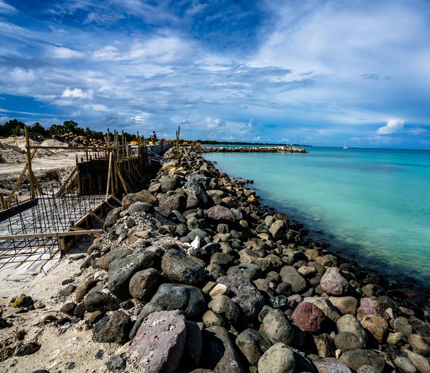
strategies to reinforce the coastal edges of urban atolls to withstand moderate sea level rise and the elevated
risk of coastal flooding. The measures under Protect, such as seawalls and revetments, are only effective for low
to intermediate levels of sea level rise. With 0.5m sea level rise, around 80km of Majuro shoreline need to be
protected. As sea levels continue to rise, and coastal inundation increases, it is likely that more transformational
resilience measures will be needed in the medium to long term. Protect is a considered a short-term adaptation
strategy that buys time to plan for and invest in pathways like Raise, Reclaim, or Relocate. These are expensive
but robust pathways that can withstand sea level rise of 1–2m, or more.
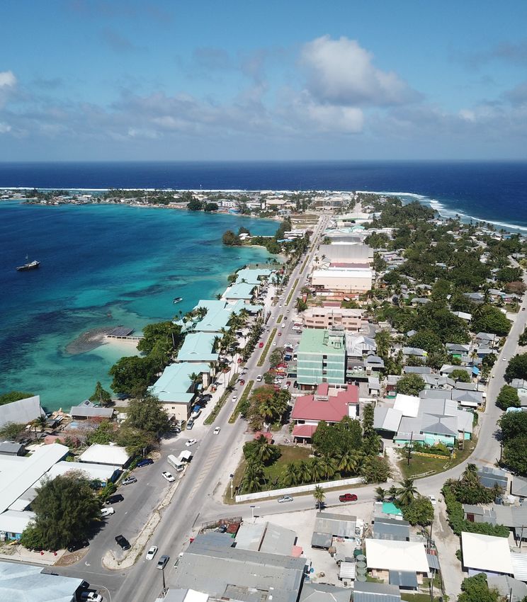
Photo: Majuro atoll and Majuro town in Marshall islands. Source: Getty Images.
Guidance for Managing Sea Level Rise Infrastructure Risk in Pacific Island Countries | Page 21You can also read