HIGHWAY MAINTENANCE MANAGEMENT PLAN - VOLUME 4 WINTER SERVICE 2021/22 - October 2021 - Wokingham ...
←
→
Page content transcription
If your browser does not render page correctly, please read the page content below
HIGHWAY MAINTENANCE

                    MANAGEMENT PLAN

                             VOLUME 4

                          WINTER SERVICE

                              2021/22

Place and Growth,
Wokingham Borough Council,
PO Box 153,
Council Offices,
Shute End,
Wokingham, Berkshire.
RG40 1WL

Tel No.   0118 974 6000

                                           October 2021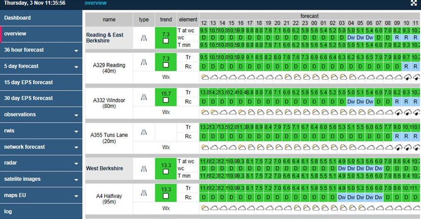
HIGHWAY MAINTENANCE MANAGEMENT PLAN

Volume 1:   Introduction & Overview

Volume 2:   Highway Network Maintenance

Volume 3:   Highway Drainage

Volume 4:   Winter Service

Volume 5:   Severe Weather and other Emergencies

Volume 6:   Highway Structures

Volume 7:   Traffic & Transport (incl Traffic Management & Road Safety)

Volume 8:   Street Lighting and Illuminated Signs

Volume 9:   Other Miscellaneous Functions
            Including:
            Sweeping and Street Cleansing
            Weed Control
            Verges and Open Spaces
            Trees
            Grass Cutting
            Public Rights of Way

Volume 10: Highway Development Control
HIGHWAY MAINTENANCE MANAGEMENT PLAN
VOLUME 4 – WINTER SERVICE
CONTENTS
SECTION PAGE
1. POLICY STATEMENT ........................................................................................1
2. INTRODUCTION.................................................................................................1
3. ROAD HIERARCHY AND THE NETWORK .......................................................4
4. CLIENT/CONTRACTOR RELATIONSHIP .........................................................8
5. ROSTERING OF SUPERVISORY AND OPERATIONAL STAFF ......................9
6. PLANT AND VEHICLES...................................................................................10
Snow Clearance ................................................................................................10
Operational Communications ............................................................................10
7. WEATHER FORECASTS .................................................................................11
8. DECISION MAKING .........................................................................................13
9. SALT AND SALT BINS ....................................................................................14
Salt Cell and Mutual Aid to neighbouring highway authorities ...........................15
10. SNOW CLEARING ...........................................................................................16
11. MEDIA COMMUNICATIONS ............................................................................17
12. WINTER SERVICE CROSS BOUNDARY ARRANGEMENTS ........................17
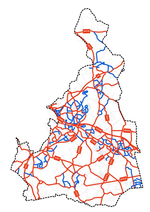
Appendix A – Salting Networks ..............................................................................18
Appendix B – Plan showing primary and secondary salting networks ..............39
Appendix C - Location of structures (bridges, viaducts etc.) on primary network ..40
Appendix D - Salt Bin Locations ............................................................................41
Appendix E - Snow Clearing ...................................................................................42
Appendix F - Guidance Notes for Winter Duty Officers .......................................47
Appendix G - Winter Service Call Out Guidelines ................................................48

Appendix H - Example of a Typical Weather Forecast .........................................49

Appendix I - Sample Decision Sheet ......................................................................50

Appendix J - Circulation List ..................................................................................50

Appendix K - References ........................................................................................53
1.    POLICY STATEMENT

1.1   Wokingham Borough Council aims to provide a service to reduce as far as possible
      the effects of hoar frost, ice and snow to provide travelling conditions as safe as
      reasonably practicable having regard to financial constraints and the road hierarchy,
      and to fulfil the other functions set out in this Winter Service Plan.

2.    INTRODUCTION

2.1   Wokingham Borough Council will provide a Winter Service enabling, as far as is
      reasonably practical, the safe movement of traffic on all maintenance category 1
      and 2 roads, the majority of category 3a roads and other well trafficked roads
      throughout the borough. Wokingham Borough Council currently has a duty to
      maintain highways maintainable at public expense under Section 41 of the
      Highways Act. Section 41 was amended in October 2003 to place a duty upon local
      authorities in England and Wales to ensure that safe passage along the highway is
      not endangered by snow or ice. This amendment will be conditional to those
      measures which are reasonably practicable for Wokingham Borough Council.

2.2   This Winter Service Plan forms part of Wokingham Borough Council’s Highway
      Maintenance Management Plan.

2.3   It is reviewed annually in order to address any issues raised as a result of
      operational problems, changes in working methods, changes in best practice
      guidance, new legislation etc. The review includes examination of the following:

      • Skidding accidents, where freezing conditions have been cited in Thames Valley
        Police personal injury (PI) accident reports
      • The location of on-road, shared or dedicated cycle routes
      • Bus routes
      • Known wet spots
      • Bridge-decks/viaducts etc.
      • Partnership working with the Highway Maintenance Term Contractor
        (VolkerHighways), other departments of the council and other contractors etc.
      • Previous snow events and their impact on the borough and its residents.
      • Comments from the Parish and Town Councils, members and residents.
      • Requests for additional salt bins from the Parish and Town Councils, members
        and residents.
      • Car parks
      • Coronavirus

2.4   Roads forming a “Primary” pre-salting and “Secondary” salting network have been
      defined and are shown in Appendix A. These routes are the most heavily used in
      the borough and include the majority of bus routes.

2.5   Pre-salting and snow clearance of the Primary routes will be carried out based on
      information received from the weather forecasting service. Secondary routes will
      only be salted and/or cleared of snow during particularly severe and prolonged
      hazardous weather conditions. In certain circumstances it may be necessary to

                                            1
apply salt after the formation of icy patches due to unforeseen circumstances such
as burst water mains for example.
2.6 For precautionary salting, the response and treatment times for roads within
Wokingham Borough are 1 hour to commence salt run and 3 hours to complete the
salt run. For clarification, precautionary salting of the primary network will be
completed within 4 hours of initial notification to the contractor. Consideration will be
given to the need to apply salt to footways and cycleways during prolonged periods
of severe weather.
2.7 The Council’s Contractor, VolkerHighways will provide a standby and basic facility
for a period of twenty weeks. This will commence from the third week in November
2021 and finish the last week of March in 2022.
2.8 The Council has a duty under section 150 of the Highways Act 1980 and Section
111 of the Railways and Transport Safety Act 2003 to remove accumulations of
snow if causing a highway to become obstructed. Roads will, therefore, be cleared
of snow in descending order of priority until such time as all the Primary routes are
cleared. This will be followed by clearance of the secondary routes. Then, if other
roads are physically blocked or particularly hazardous further action will be taken as
resources permit.
2.9 In order to rationalise the approach made to salting other roads in the borough a
‘Third Tier’ Salting Network has been created. This will enable roads not on the
Primary or Secondary networks to be treated in a more focused way rather than
responding to ad-hoc requests from residents and other road users. The ‘Third Tier’
Salting Network comprises roads that will only be salted following extreme snow
events (refer to Section - 10 Snow Clearing).
2.10 Footways in town centres and outside schools (as detailed in Appendix E) will also
be cleared of snow as soon as resources allow. These works will generally be
carried out by hand. Salt will be hand-applied when surfaces are sufficiently clear of
snow.
2.11 The Council does not recommend the use of bicycles during periods of prolonged
hazardous conditions. Cyclists should exercise caution and only cycle in freezing
conditions if they feel safe to do so. With the exception of shared
carriageway/cycleway routes on a primary or secondary salting route, shared
footway/cycleway and remote cycleway networks are not salted when hoar frost, ice
or prolonged hazardous conditions are forecast. Being part of the carriageway,
shared carriageway/cycleway routes on the primary and secondary salting route
networks will be salted by default as part of these routes in accordance with the
Winter Service Plan. The low volume of use and nature of cycle routes in the
borough mean that salting dedicated routes would not be effective and re-freezing
would likely occur shortly after application. We continue to monitor cycling levels
and if routes are identified that would benefit from salting, they will be added to the
secondary salting network.
2.12 Salt bins are provided at various locations on the highway throughout the borough.
These are listed in Appendix D. The council’s salt bins are yellow which will be
replenished during the winter season. There are also green grit bits on the networks
which are privately owned and are not the responsibility of Wokingham Borough
Council.
2.13 The Council will not routinely pre-salt any of its open-air public car parks, where
frost/ice is expected to thaw within a reasonable time. However, during prolonged
2hazardous weather or following a forecast of heavy snow or hoar frost where
conditions are not expected to improve naturally, a salt/grit mix will be applied to
areas around ticket machines and main pedestrian access points but vehicle
running areas and parking bays will not be routinely treated.
2.14 Car parks may not be cleared of snow if conditions are expected to improve
naturally with 24 hours. Clearance rotas will be prioritised and therefore not all car
parks will be cleared at the same time. At times of heavy snow, where conditions
are not expected to improve naturally within 24 hours, accumulations of snow will be
cleared from car parks at the earliest opportunity, once snow stops falling. Cleared
snow will be stockpiled at appropriate positions within the car park and areas which
have been cleared will be treated with a salt/grit mix.
2.15 In exceptional circumstances, subject to a risk assessment and taking into account
the safety of users, the Parking Operations Manager may take the decision to
temporarily suspend parking in any of the council’s car parks without advance
notice.
2.16 The Park and Ride sites situated at Mereoak Lane, Shinfield, Wharfdale Road,
Winnersh and Thames Valley Park and Ride, Earley. will be pre-salted as per the
requirements of the Primary Road network, each time an instruction is issued the
set down areas will be salted. The areas allocated for the parking of cars will only
be salted when an instruction is given by the Parking Manager.
2.17 For emergency requests relating to snow clearance or winter service activities will
be managed by a call centre and will follow Table 8: CRM Service Request
Assessment, Action and Customer Response (HMMP Volume 2).
32.18 ROAD HIERARCHY AND THE NETWORK
2.19 The road hierarchy within the borough is defined in the “Highway Maintenance
Management Plan”. The maintenance categories are listed in the following table.
Category Hierarchy Type of Road Detailed Description
Description General Description
1 Motorway Limited access Routes for fast moving long distance traffic.
(A329M and motorway regulations Fully grade separated and restrictions on
A3290 only) apply use
2 Strategic Trunk and some Routes for fast moving long distance traffic
Route Principal “A” roads with little frontage access or pedestrian
between Primary traffic. Speed limits are usually in excess of
Destinations 40 mph and there are few junctions.
Pedestrian crossings are either segregated
or controlled and parked vehicles are
generally prohibited
3a Main Major Urban Network Routes between Strategic Routes and
Distributor and Inter–Primary linking urban centres to the strategic
Links. Short – network with limited frontage access. In
medium distance urban areas speed limits are usually 40
Traffic mph or less, parking is restricted at peak
times and there are positive measures for
pedestrian safety
3b Secondary Classified Road (B In rural areas these roads link the larger
Distributor and C class) and villages and HGV generators to the
unclassified urban Strategic and Main Distributor Network. In
bus routes carrying built up areas these roads have 30 mph
local traffic with speed limits and very high levels of
frontage access and pedestrian activity with some crossing
frequent junctions facilities including zebra crossings. On
street parking is generally unrestricted
except for safety reasons
4a Link Road Roads linking In rural areas these roads link the smaller
between the Main villages to the distributor roads. They are of
and Secondary varying width and not always capable of
Distributor Network carrying two way traffic. In urban areas they
with frontage access are residential or industrial inter–
and frequent connecting roads with 30 mph speed limits
junctions random pedestrian movements and
uncontrolled parking
4b Local Access Roads serving In rural areas these roads serve small
Road limited numbers of settlements and provide access to
properties carrying individual properties and land. They are
only access traffic often only single lane width and unsuitable
for HGV. In urban areas they are often
residential loop roads or culs de sac
2.20 The Primary precautionary salting network comprises all maintenance category 1
and 2 roads, the majority of category 3a roads and other well trafficked roads. The
total length of the Primary salting network is approximately 272Km (169 miles) and
represents 38% of all the boroughs publicly maintained highways (excludes the
M4).
2.21 Bridge deck surfaces can be colder than the approach roads. The treatment of large
viaducts/overbridges within the borough will be increased to a double pre-salt, e.g.
4a 8g/m2 spread rate will be 16g/m2 on Winnersh Viaduct. A list of structures that
will be double-salted is shown in Appendix C. Consideration will also be given to
apply salt to bridge-decks only, on occasions when the decision to not salt the rest
of the network is borderline.
2.22 The primary pre-salting network is broken down into salting routes. These routes
are designed by the contractor to give a maximum treatment time of three hours. It
should be noted that the response time at any time of night or day is one hour.
2.23 The Secondary salting network comprises the main routes leading to schools, bus
routes, some residential roads and lightly trafficked rural roads which become
hazardous if left untreated during prolonged periods of particularly severe weather
conditions. The decision to treat the Secondary network (including timings and
sequencing) will be made by the contractor and may follow discussions with the
client. The total length of the Secondary salting network is 96Km (60 miles) and
represents a further 14% of all the boroughs publicly maintained highways.
2.24 The pedestrian area in Woodley (known as Woodley Precinct) is an area separated
from any carriageways. Unlike pedestrian areas in other town centres in the
borough it does not therefore benefit from any residual salt that might tend to ‘spill’
on to adjacent footways from ordinary carriageway salting operations. Whilst there
are salt bins in and around Woodley Precinct it is recognised that these cannot
always be close to where slips and falls might occur. The precinct will therefore be
salted on an ad-hoc basis when deemed necessary based on a joint decision
between the contractor and client. The method of salt-spreading will be determined
by the contractor.
2.25 The salting of any new infrastructure including carriageways, footways/footpaths,
cycleways etc will be considered as they come ‘on-line’
2.26 Arrangements previously made with adjoining counties and unitary authorities to
treat lengths of road beyond the borough’s boundaries and vice versa have been
reviewed to take into account changes in legislation (see section 12 for details).
2.27 Footways maintenance categories are listed in the following table.
Category Category Name Brief Description
1 Primary Walking Route Busy urban shopping and business areas, and main
pedestrian routes linking interchanges between different
modes of transport, such as railways and underground
stations, and bus stops etc.
2 Secondary Walking Route Medium usage routes through local areas feeding into
primary routes, local shopping centres, large schools
and industrial centres etc.
3 Link Footway Linking local access footways through urban areas and
busy rural footways
4 Local Access Footway Footways associated with low usage, short estate roads
to the main routes and cul de sacs
Whilst footways/cycleways are not normally pre-salted, they will be cleared of snow
in town centres and outside schools when the need arises. Consideration will be
given to the need to pre-salt additional footways and cycleways during prolonged
periods of severe weather. A list of town centre footways/cycleways to be routinely
cleared of snow is included as Appendix E.
52.28 Details of the salting network/gritting routes and salt bin locations are provided in
Appendices A and D respectively.
6M4 Motorway
2.29 The treatment of the M4 motorway is to be completed by contractors instructed by
Highways England Area 3’s managing agent.
73. CLIENT/CONTRACTOR RELATIONSHIP
3.1 Wokingham Borough Council, the Highway Term Maintenance Contractor
VolkerHighways are members of the party that forms the ‘Wokingham Highway
Alliance’. The Highway Term Maintenance contract includes the provision of winter
services.
3.2 Innovative ideas proposed by the client or contractor that provide improvements in
quality of service and/or cost benefits will be adopted during the course of the
Highway Term Maintenance contract. An example would be the examination of the
direction of travel during a pre-salting run to ensure maximum desired coverage is
achieved.
3.3 The following table indicates how the principal Winter Service responsibilities
between the Council and contractor are split:
Preparation of Winter Service Plan VolkerHighways
Road hierarchy priorities Wokingham Borough Council
Salt purchase VolkerHighways
Routing (salting and snow VolkerHighways
clearance
Vehicles/plant Owned/hired and routinely maintained by
VolkerHighways
Winter Service Delivery VolkerHighways
Manager/Decision making
Day-to-day operations VolkerHighways
Manning levels As defined in term maintenance contract
Performance monitoring VolkerHighways / Wokingham Borough
Council
Opening of Emergency Operations Wokingham Borough Council
Centre and Emergency Planning
Room
Approval to commence operations VolkerHighways with support from
in extreme snow conditions Wokingham Borough Council Officers
3.4 The contractor will, following each salt run, provide a report confirming receipt of the
salting decision and action taken. Also it should detail the location of any wet spots
and other observations on the Network e.g. are there any problems on the network
– fallen trees, leaks, blocked gullies, significant potholes, damaged safety
fencing/guardrail, damaged structures, damaged lighting columns or street furniture.
Any information received that could affect the safety of the highway will then be
entered into a log and on marginal forecasts where a full pre-salt run is not
instructed the forecaster may instruct these areas to be treated to prevent ice
formation.
84. ROSTERING OF SUPERVISORY AND OPERATIONAL STAFF
4.1 The Contractor’s team of Winter Duty Officers is rostered to be on standby for the
winter period, which is generally November to March inclusive. The roster is held by
the contractor.
4.2 Each duty officer is available 24 hours a day, during their week on duty. During
normal office hours all Winter Service enquiries from members of the public will be
received by Wokingham Customer Services, and where the policy applies,
information forwarded onto the contractor VolkerHighways.
4.3 Outside office hours, enquiries will be directed to the council’s call-out facility
‘Beyond Housing’ and if necessary forwarded to the contractor. (Officers’ home
telephone numbers will not be released to members of the public.)
4.4 When on duty, the Winter Duty Officer will make decisions regarding winter service
action required. Should the duty officer be in any doubt about a decision he will
contact the Winter Service Delivery Manager. Further information concerning
weather forecasts and decision making is provided in sections 7 and 8.
4.5 Rosters of all of the contractor’s staff involved in winter service operations are
requested during September in preparation for commencement of operations in
November.
4.6 All of the contractor’s salt spreading vehicle operators are in possession of The City
and Guilds Institute (scheme 6159) ‘Winter Maintenance Operators Qualification’.
4.7 Prior to the commencement of the winter period, each Winter Duty Officer will be
provided with an information pack, which includes details of all appropriate
telephone contacts, together with a copy of this document and any other additional
information that may be appropriate.
95. PLANT AND VEHICLES
5.1 The Council’s contractor VolkerHighways owns/hires and maintains all the
equipment used for Winter Service operations.
5.2 Prior to the operational winter service period the contractor will carry out a ‘dry’ run
of each precautionary salting route and fit and remove snow ploughs to every
vehicle prior to the end of September.
5.3 To be effective, salt must be spread evenly and at rates to suit prevailing weather
conditions. Excessive salt spreading is undesirable on both environmental and
economic grounds. To this end, it is essential that the spreading equipment is
calibrated annually in accordance with BS 1622 and the controls marked
accordingly for spreads of 8g/m2 for normal pre-salting and 16g/m2, 30g/m2 and
40g/m2 for more severe conditions.
Snow Clearance
5.4 The Highway Network Term Contract (2019-2026) requires the contractor to provide
all necessary equipment for the clearance of snow.
Operational Communications
5.5 All contractors’ vehicles are equipped with a mobile telephone.
5.6 All salting vehicles are fitted with a Global Positioning System (GPS) to record
operational efficiency. Routes can then be reviewed using Masternaut software to
ensure that the designated route is treated. The software can be used to provide
details of vehicle speed, location, salt-spread rate, time/date, vehicle and driver
identity.
X`
106. WEATHER FORECASTS
6.1 During the winter period, VolkerHighways uses the Roadcast forecasting service
provided by DTN (Meteogroup). The regional office providing this service is the DTN
(Meteogroup) Weather Centre. The forecast provided by DTN (Meteogroup) is
tailored for Berkshire. The information received each day includes the following:
(i) Detailed 36-hour forecast
(ii) Evening update forecast
(iii) Early morning summary
(iv) 2 - 10 day forecast
(v) forecasts specific to sensor sites
(vi) live data from sensors
In addition, radar pictures can be provided when appropriate.
6.2 The 36-hour forecast is received between 11:00 and 12:00 hours each day. The
main features of this forecast are as follows:
(i) Readiness colour
This is based on the traffic light colours, green, amber or red. The definitions
are:
Green: no snow or ice expected
Amber: risk of snow or ice
Red: snow, ice or drifting snow expected
(ii) Hazards
This section includes the hazards causing the red or amber readiness colours
as well as other weather hazards such as heavy rain, high winds or fog, which
could accompany a green readiness colour. Where possible a qualifying time
is given, for example, icy patches expected after 23:00 hours.
(iii) Minimum temperatures
Minimum air and road temperatures for urban, semi-urban and rural areas are
provided.
(iv) Confidence statement
This consists of high, moderate or low confidence for each of the hazards
described above, together with a qualifying statement, for example: low
confidence regarding extent of showers this evening but high regarding road
temperatures falling below zero.
(v) 36 hour weather summary
This is a general summary of the forecast. This forecast constantly updates,
giving data for the next 36hr period.
An example of a typical forecast is shown in Appendix H.
116.3 At approximately 17:00 hours a forecast update is issued by the DTN (Meteogroup)
Weather Centre if there is any significant change from the afternoon forecast and
can be viewed by the Winter Duty Officer at home on their portable laptop
computer. If further information is required, the Winter Duty Officer can make use of
the 24 hour consultancy service provided by DTN (Meteogroup) Weather Centre
when a discussion can be held with the duty forecaster (see section 8 for further
information on decision making).
6.4 In the event that there is a change to the weather forecast issued by DTN
(Meteogroup) Weather Centre then they will contact the Winter Duty Officer,
informing them of the change, which could lead to a revision to the action required.
WEATHER MONITORING STATIONS
6.5 There are five dedicated weather monitoring stations in Berkshire. These comprise
road surface and atmospheric condition sensors. Every hour, information from these
stations is processed automatically by “Vaisala TMI Ltd” whose offices are based in
Birmingham. The resulting information from selected weather monitoring stations is
then made available to the contractor’s Winter Duty Officer via a laptop computer.
This, together with information provided by DTN (Meteogroup) Weather Centre is
used to determine what action, if any, should be taken.
6.6 A technique known as “thermal mapping” was used to optimise the location of the
stations. Annual calibration checks on all sensors are undertaken by the appropriate
equipment supplier this is jointly funded by the six Berkshire Unitary Authorities.
6.7 The parameters recorded by the sensors include air temperature, humidity,
precipitation, wind speed and direction, road surface temperature, surface condition
(wet or dry), depth temperature and residual salt levels.
127. DECISION MAKING
7.1 Decision making is the responsibility of VolkerHighways appropriate Winter Duty
Officer. Each day during the winter season the Winter Duty Officer will be on
standby.
7.2 The Winter Duty Officer also has a specific responsibility for liaising directly with the
DTN (Meteogroup) Roadcast forecaster and for disseminating information as
described in Section 7.
7.3 Using the forecast data provided, the Winter Duty Officer will make their decision
regarding pre-salting as appropriate. To assist with this process, guidance notes are
provided together with call out guidelines as shown in Appendices F and G
respectively. The Winter Duty Officer also has the responsibility for receiving
information relative to the conditions prevailing in the borough and taking the
appropriate action. Forecasters will keep a record of all decisions made, whether
salting is instructed or not, the reason for that decision and any conversations
regarding that decision. Once the Winter Duty Officer has reached their decision the
Winter Duty Officer is to confirm the action required.
7.4 The Winter Duty Officer’s decision is recorded on a decision sheet as shown in
Appendix I. Also to be recorded on the decision sheet are any important
conversations with the DTN (Meteogroup), this sheet will then be disseminated and
filed for future reference.
7.5 When snow is forecast the clearing/ploughing strategy is to be controlled by
VolkerHighways. In times of prolonged severe weather staff from Wokingham
Borough Council may temporarily relocate to the contractor’s depot at Toutley in
order to direct operations in the most effective way possible.
7.6 The winter service contractor is contacted via their nominated winter service
supervisor by telephone; this is manned 24 hours per day. A decision sheet is e-
mailed to confirm the instruction.
7.7 Appropriate training is provided regularly for all Winter Duty Officers, particularly
with regard to technological improvements in forecasting techniques and the ice
prediction system.
138. SALT AND SALT BINS
8.1 Rock salt complying with BS3247 is supplied by the Contractor responsible for
Winter Service operations on the network and is stored at Toutley Depot.
8.2 It is the responsibility of the contractor to maintain adequate salt stocks.
8.3 The maximum salt stock level is 1,500 tonnes with re-ordering triggered when
stocks fall to minimum quantities as per Table 1 Salt Stockpiles (Appendix L)
8.4 Salt bins, for use on the highway, are provided at various locations throughout the
borough and are maintained and replenished on a regular basis throughout the
winter period as necessary. At the end of the winter, all salt bins are collected and
the bins cleaned and stored away during the summer months.
The criteria for provision of salt bins are as follows:
(i) The bin should not be sited on a primary salting route unless it is intended for
use on an adjoining road that is not on the route.
(ii) Only sited where there is a steep and/or hazardous gradient and where there
are occupied buildings nearby.
(iii) If it is possible for a lorry to gain access in order to install the bin and fill with
salt, then location near subway or footbridge is acceptable.
(iv) In cases of special needs.
8.5 Should it be necessary, the budget-holder for Winter Maintenance may give
approval for the provision of additional salt bins. A decision will be based on need
and available budget.
8.6 A list of current salt bin locations is attached as appendix D.
8.7 Assistance to other Wokingham Borough Council stakeholders (e.g. schools,
sheltered housing establishments, libraries, Parish and Town Councils and even
residents associations) will be provided where requests are made sufficiently in
advance of the commencement of the 20-week winter service period (which starts
on the third week in November) and will be limited to the initial supply of salt bins
and salt. However, this provision will be fully funded by the stakeholder who will also
be required to make arrangements for any spreading of the salt provided. It is the
responsibility of all council departments (for business continuity purposes) and other
parties to make their own arrangements in preparation of severe weather events.
Where new salt bins are provided to others they will be coloured green to
differentiate them from the yellow ones used by the Highway Alliance.
14Salt Cell and Mutual Aid to neighbouring highway authorities
8.8 In early 2009 representatives from the DfT, the Local Government Association, the
Highways Agency and the Cabinet Office came together to form a so-called 'Salt
Cell', whose purpose was to direct the salt-supplying companies to the areas most
in need, regardless of existing contracts they may have with local authorities.
Following the severe snow falls in December 2009 and January 2010 a Thames
Valley Salt Cell was also established. Meetings hosted by Thames Valley Police
with representatives from the relevant local highway authorities (including
Wokingham Borough Council) included discussions relating to;
• Rationalising cross-boundary salting routes (where one highway authority shares
a boundary with another);
• Salt stock levels, including any mutual aid that one authority might offer another
in the event of salt supply shortages;
• Improving communications between (a) authorities and (b) members of the public
8.9 Wokingham Borough Council and its neighbouring authorities have agreed that a
general spirit of ‘mutual aid’ should exist. Assistance sought by neighbouring
councils covering a range of functions should be made available if requested and
wherever possible and appropriate. It is expected, therefore, that if a neighbouring
highway authority becomes critically low on salt stock levels due, for example, to a
national shortage, then support should be offered by those with adequate supplies.
Wokingham Borough Council will offer such support to neighbouring highway
authorities if and wherever possible. Support will not be offered, however, if the
Council’s salt stock levels fall below those sufficient to treat the Primary and
Secondary Salting Network at the Code of Practice for Highway Maintenance
Management’s recommended contingency rate (currently 6 successive treatments
at 16g/m2 on 6 successive days).
159. SNOW CLEARING
9.1 When conditions are such that snow clearing becomes necessary, an instruction
will be made by VolkerHighways Winter Duty Officer (confirmed by e-mail) to
commence snow-clearing operations. The Contractor is required to provide the
necessary equipment for the clearance of snow.
9.2 Instructions to clear snow will come from VolkerHighways Winter Duty Officer. If
Council officers receive requests for roads to be salted, they are to pass the
information to the Winter Duty Officer. The highway network will be cleared in
descending order of priority, concentrating firstly on the clearance of the primary
salting network followed by the secondary network and the footways shown in
Appendix E.
9.3 Once the contractor has confirmed that these routes are cleared all available
resources will then diverted to the clearance of other roads on the network.
9.4 If large-scale snow clearing becomes necessary an Emergency Control Centre
(ECC), located at the council’s Shute End offices or the contractors depot, may be
opened and manned until conditions abate. During this time, all operational calls
relating to winter services will be directed to the ECC. VolkerHighways will be
responsible for giving all instructions to the workforce.
9.5 In order to rationalise the approach made to salting other roads in the borough a
‘Third Tier’ Salting Network has been created. This will enable roads not on the
Primary or Secondary networks to be treated in a more focused way rather than
responding to ad-hoc requests from residents and other road users. The ‘Third Tier’
Salting Network comprises roads that will only be salted following extreme snow
events and is shown in Appendix A.
The roads on the list are generally the larger estate roads (not each minor road, cul-
de-sac etc.), roads that may help the movement of traffic in difficult locations, roads
with difficult gradients or roads that are considered to lead to significant numbers of
vulnerable residents.
The decision to commence salting the ‘Third Tier’ Salting Network will only be taken
once the Primary and Secondary routes are clear and if sufficient resources (labour,
plant, salt stocks etc.) are available. The total length of the ‘Third Tier’ Salting
Network is 151km (94 miles).
9.6 In accordance with the recommendations of the ’Lessons Learned from the Severe
Weather February 2009’ report, the Council has developed a ‘Contingency Salting
Network’ to cover prolonged periods and heavy accumulations of snow and national
salt shortages. The network consists of all principal roads (‘A’ roads) and other
roads servicing important sites and locations (e.g. emergency services, major food
depots etc.) and is designed to ensure the most critical infrastructure and services
are maintained. The roads form a sub-set of the Primary Salting network and are
highlighted in Appendix A.
9.7 Central government has issued a ‘Snow Code’ which includes advice to residents
with regard to ‘self-help’ (clearance of snow from roads and footways outside their
own house). Further information will be made available on the council’s website.
1610. MEDIA COMMUNICATIONS
10.1 Liaison with the news media, particularly the local radio stations, BBC Radio
Berkshire and Heart FM is of the utmost importance and will be maintained during
periods of severe snowfall.
10.2 It is also desirable that communications with the local police force is maintained. To
this end, whenever an instruction to salt is issued a copy of the decision sheet will
be e-mailed to the Thames Valley Police Headquarters at Kidlington. Additional
information will also be provided as appropriate to the motoring organisations during
periods of snow clearance when it is essential that the travelling public are advised
of current road conditions and cleared routes.
10.3 Information on the current policy and pre-salting plans will be circulated to libraries.
11. WINTER SERVICE CROSS BOUNDARY ARRANGEMENTS
11.1 Due to changes in legislation previous cross boundary arrangements have been
examined and legal advice sought.
11.2 The Borough council will now salt up to and including its boundaries with
neighbouring councils.
11.3 Where it is necessary for the salting vehicles to pre-salt a road divided by the
borough boundary Wokingham Borough Council will salt up to the point at which the
vehicle turns around (the cost for this is negligible). This does not constitute any
form of agreement or responsibility for the treatment of highways outside the
borough boundary it is merely to ensure full coverage of Wokingham Borough
Council’s salting network.
17Appendix A – Salting Networks
The Primary Salting Network
The roads shown followed by ‘(CSN)’ form the ‘Contingency Salting Network’ (see Section 10 –
Snow Clearing, for further information).
Salting will not generally be carried out on any spur roads, cul-de-sacs etc. off the main through-
routes listed (even if they bear the same name as those roads).
PRIMARY SALTING NETWORK
A3290 (A4 Slip Roads), Earley (CSN)
A3290, Earley (CSN)
A3290, Woodley (CSN)
A329M (Coppid Beech Slip Roads), Wokingham (CSN)
A329M (Winnersh Triangle Slip Roads), Winnersh (CSN)
A329M, Winnersh (CSN)
A329M, Wokingham (CSN)
A33 Basingstoke Road Link (A33), Shinfield
A33 Bus Link to M4, Shinfield
A33 Mereoak Lane Link (A33), Shinfield
A33 Swallowfield Bypass (A33), Shinfield (CSN)
A33 Swallowfield Bypass (A33), Swallowfield (CSN)
Access from Old Forest Road to Depot, Wokingham (CSN)
Arborfield Road (A327), Shinfield (CSN)
Barkham Ride, Barkham
Barkham Ride, Finchampstead
Barkham Road (B3349), Barkham (CSN)
Barkham Road (B3349), Wokingham (CSN)
Barkham Street, Barkham
Basingstoke Road (B3349), Shinfield
Basingstoke Road (B3349), Swallowfield
Basingstoke Road, Shinfield
Bath Road (A4), Charvil (CSN)
Bath Road (A4), Sonning (CSN)
Bath Road (A4), Wargrave (CSN)
Bearwood Road, Barkham (CSN)
Bearwood Road, Winnersh (CSN)
Beech Hill Road, Shinfield
Beech Lane, Earley
Beechwood Avenue (Reading Road to Lytham Road), Woodley
Beeston Way, Earley (CSN)
Bellfoundry Lane, Wokingham
Berkshire Way (A329) (Coppid Beech Slip Roads), Wokingham (CSN)
Berkshire Way (A329), Wokingham (CSN)
Betchworth Avenue, Earley
Biggs Lane, Barkham
18PRIMARY SALTING NETWORK
Binfield Road, Wokingham
Binfield Road, Hurst
Black Boy roundabout (A327), Shinfield (CSN)
Bloomfieldhatch Lane (Grazeley Green Road to Lambwood Hill), Shinfield
Broad Street (A329), Wokingham (CSN)
Broadwater Lane (A321), Hurst (CSN)
Broadwater Lane (A321), Twyford (CSN)
Brookers Hill, Shinfield
Bunglers Hill, Swallowfield
Butts Hill Road, Sonning
Butts Hill Road, Woodley
Chalfont Way, Earley
Charvil Lane (B478), Sonning
Church Lane, Shinfield
Church Road (B3350), Earley
Church Road (A327 Reading Road to Bunglers Hill), Finchampstead
Church Road (A327 Reading Road to Bunglers Hill), Swallowfield
Church Road (Swallowfield Road to Swallowfield Street), Swallowfield
Church Street (A321), Twyford (CSN)
Coppid Beech Rbt (A329), Wokingham (CSN)
Crockhamwell Road, Woodley
Davis Street (B3030), Hurst
Denmark Street (A321), Wokingham (CSN)
Diamond Jubilee Way, Wokingham
Doles Hill (B3349), Wokingham (CSN)
Dukes Ride (B3348), Finchampstead
Easthampstead Road, Wokingham
Easthampstead Road, Wokingham Without
Elm Lane, Earley
Elm Road (B3350), Earley
Eversley Road (A327), Arborfield (CSN)
Finchampstead Road (A321), Wokingham (CSN)
Finchampstead Road (B3016), Finchampstead
Fleet Hill (B3348), Finchampstead
Forest Road (B3034), Hurst
Gipsy Lane, Earley
Glebelands Road (A321), Wokingham (CSN)
Goring Lane (Grazeley Green Road to borough boundary), Shinfield
Grazeley Green Road (Bloomfield Hatch Lane to Goring Lane), Shinfield
Great Lea, Shinfield
Hartley Court Road, Shinfield
Hatch Farm Way, Winnersh (CSN)
Headley Road East (Loddon Bridge Road to Spitfire Way), Woodley
Headley Road, Woodley
19PRIMARY SALTING NETWORK
Heathlands Road, Wokingham Without
Henley Road (A4130), Remenham (CSN)
High Street (A3032), Twyford (CSN)
High Street (A321), Wargrave (CSN)
Hollow Lane (A327), Shinfield (CSN)
Holt Lane, Wokingham
Hurst Road (A321), Twyford (CSN)
Hyde End Road (B3349), Shinfield
Jubilee Avenue (Holt Lane to A321 Milton Road), Wokingham
Jubilee Road (B3016), Finchampstead
Keephatch Road, Wokingham
Kilnsea Drive, Earley
King Street Lane (B3030), Winnersh (CSN)
Kirtons Farm Road, Shinfield
Lambwood Hill, Shinfield
Langley Common Road, Arborfield (CSN)
Langley Common Road, Barkham (CSN)
Loddon Bridge Interchange - Bader Way (A329), Winnersh (CSN)
Loddon Bridge Road, Earley
Loddon Bridge Road, Woodley
Loddon Hall Road, Twyford
Lodge Road (B3030), Hurst
London Road (A3032), Ruscombe (CSN)
London Road (A3032), Twyford (CSN)
London Road (A3032), Wargrave (CSN)
London Road (A329), Wokingham (CSN)
London Road (A4), Earley (CSN)
London Road (B3408), Wokingham (CSN)
Longdon Road, Winnersh (CSN)
Longwater Road (B3016), Finchampstead
Lower Earley Way (B3270), Earley (CSN)
Lower Earley Way North (B3270), Winnersh (CSN)
Lower Earley Way West (B3270), Earley (CSN)
Lower Earley Way West (B3270), Shinfield (CSN)
Lower Wokingham Road (A321), Finchampstead (CSN)
Luckley Path, Wokingham
Lytham Road, Woodley
Maidenhead Road, Hurst
Market Place (A321), Wokingham (CSN)
Matthewsgreen Road, Wokingham
Mereoak Lane, Shinfield
Mereoak Park Access Slope, Shinfield
Miles Way, Woodley
Mill Lane (Gipsy Lane to Toseland Way), Earley
20PRIMARY SALTING NETWORK
Milton Road (A321), Wokingham (CSN)
Mole Road (B3030), Arborfield
Mole Road (B3030), Winnersh
Molly Millars Lane, Wokingham (CSN)
Mumbery Hill (B477), Wargrave
Murdoch Road (Easthampstead Road to Sturges Road), Wokingham
New Bath Road (A4), Charvil (CSN)
New Bath Road (A4), Twyford (CSN)
New Bath Road (A4), Wargrave (CSN)
New Wokingham Road, Wokingham Without
Nine Mile Ride (B3430), Finchampstead
Nine Mile Ride (B3430), Wokingham Without
Oak Avenue, Wokingham
Observer Way, Arborfield
Odiham Road (B3349), Swallowfield
Old Bath Road (A3032), Charvil (CSN)
Old Bath Road (A3032), Twyford (CSN)
Old Forest Road, Wokingham (CSN) (including New section to Toutley road)
Oxford Road, Wokingham
Park Lane (Biggs Lane to Nine Mile Ride), Finchampstead
Peach Street (A329), Wokingham (CSN)
Pearson Road (B4446), Sonning
Pepper Lane, Earley
Pingewood Road South, Shinfield
Pitts Lane (B3350), Earley
Pound Lane, Sonning
Queens Road, Wokingham
Reading Road (A327), Arborfield (CSN)
Reading Road (A327), Finchampstead (CSN)
Reading Road (A327), Swallowfield (CSN)
Reading Road (A329), Winnersh (CSN)
Reading Road (A329), Wokingham (CSN)
Reading Road, Woodley
Rectory Road (A329), Wokingham (CSN)
Remenham Hill (A4130), Remenham (CSN)
Robin Hood Lane (B3030), Winnersh
Rose Street, Wokingham
Ruscombe Lane (B3024), Ruscombe
Ruscombe Road (B3024), Twyford
Rushey Way, Earley (CSN)
Sandhurst Road (A321), Finchampstead (CSN)
School Green (B3349), Shinfield
School Hill (B477), Wargrave
School Lane (B477), Wargrave
21PRIMARY SALTING NETWORK
School Road (B3349), Arborfield
School Road (B3349), Barkham
Shepherds Hill (A4), Sonning (CSN)
Shepherds Hill Rbt (A4), Woodley (CSN)
Shinfield Eastern Relief Road (new link to Black Boy R/A), Shinfield (CSN)
Shinfield Road (A327), Shinfield (CSN)
Shute End (A329), Wokingham (CSN)
Silverdale Road, Earley
Sindlesham Road (B3030), Arborfield
South Wokingham Distributor Road Eastern Gateway (between Waterloo Road &
Montague Park) (On-line December 2021)
Sonning Lane (B4446), Sonning
Spitfire Way, Woodley
Suttons Park Avenue, Earley
Station Road (A321), Wokingham (CSN)
Station Link Road, Wokingham (CSN)
Sturges Road, Wokingham
Swallowfield Road, Arborfield
Swallowfield Road, Swallowfield
Swallowfield Street, Swallowfield
Thames Street (B478), Sonning
Thames Valley Park Drive, Earley
The Bader Way, Woodley
The Ridges (B3348), Finchampstead
The Straight Mile, Hurst
The Street, Swallowfield
The Village (B3348), Finchampstead
Toseland Way (Mill Lane to Rushey Way), Earley
Toutley Road, Wokingham
Twyford Road (A321), Hurst (CSN)
Twyford Road (A321), Wokingham (CSN)
Waltham Road (A321), Twyford (CSN)
Waltham Road (B3018), Hurst
Waltham Road (B3018), Twyford
Waltham Road (B3024), Ruscombe
Wargrave Road (A321), Remenham (CSN)
Wargrave Road (A321), Twyford (CSN)
Wargrave Road (A321), Wargrave (CSN)
Warren House Road, Hurst
Warren House Road, Wokingham
Wellington Road (A321), Wokingham (CSN)
Wellingtonia Avenue (B3348), Finchampstead
Wharfdale Road (A329M slip to Loddon Bridge Interchange), Winnersh (CSN)
White Hill (A4130), Remenham (CSN)
22PRIMARY SALTING NETWORK
Whitley Wood Lane (B3270 to borough boundary (approx 70m only)), Shinfield
Whitley Wood Lane (B3270), Shinfield
Whitley Wood Lane Mini RA and access to B3270, Shinfield
Wilderness Road (B3350), Earley
Wiltshire Road (A329), Wokingham (CSN)
Wiltshire Road, Wokingham
Winnersh Park & Ride (Access Road), Winnersh
Wokingham Road (A321), Hurst (CSN)
Wokingham Road (A329), Earley (CSN)
Woodlands Avenue, Woodley
Woosehill, Wokingham
The following locations are also treated when the primary routes are salted:
1. Nightingale Road Woodley to Station Road Earley footbridge
2. Areas at the bottom of each side of the A4 Carlisle Corner footbridge
23The Secondary Salting Network
Secondary routes will only be salted and/or cleared of snow during particularly severe and
prolonged hazardous weather conditions. If the decision to treat the secondary network is made
then treatment will only commence on full completion of the primary routes.
Salting will not generally be carried out on any spur roads, cul-de-sacs etc. off the main through-
routes listed (even if they bear the same name as those roads).
SECONDARY SALTING NETWORK
Amberley Drive, Twyford
Appleton Way, Shinfield
Arbor Lane, Winnersh
Ashridge Road, Wokingham
Back Lane, Swallowfield
Baird Road (Biggs Lane to Valon Road (approx)), Barkham
Baird Road (Princess Marina Drive to Sheerlands Road), Arborfield
Baird Road (Princess Marina Drive to Sheerlands Road), Barkham
Baird Road (Valon Road (approx) to Howell Close), Arborfield
Barrett Crescent, Wokingham
Baslow Road, Winnersh
Bean Oak Road, Wokingham
Beechwood Avenue (Howth Drive to Lytham Road), Woodley
Belmont Road, Wokingham Without
Biscoe way, Wokingham
Blakes Lane, Wargrave
Blakes Road, Wargrave
Bloomfieldhatch Lane (Lambwood Hill to Borough Boundary), Shinfield
Bolton Drive, Shinfield
Borrowdale Road, Winnersh
Broad Hinton, Twyford
Budges Road, Wokingham
Bunces Shaw Road, Swallowfield
Butler Road, Wokingham Without
Carshalton Way, Earley
Castle Hill, Arborfield
Castle Hill, Swallowfield
Castle Road, Swallowfield
Charwood Road, Wokingham
Chatsworth Avenue (Churchill Drive to Baslow Road), Winnersh
Chatteris Way, Earley
Chestnut Avenue (Old Woosehill Lane to Walter Road), Wokingham
Church Hill, Hurst
Church Lane (Church Road to Bunces Shaw Road), Swallowfield
Church Road, Woodley
Churchill Drive, Winnersh
24SECONDARY SALTING NETWORK
Clares Green Road, Shinfield
Clifton Rise, Wargrave
Clifton Road, Wokingham
Clivedale Road, Woodley
Colemans Moor Lane, Woodley
Colemans Moor Road, Woodley
Colleton Drive, Twyford
Comet Way, Woodley
Commons Road, Wokingham
Coppice Road, Woodley
Crazies Hill, Wargrave
Cross Street, Wokingham
Crutchley Road, Wokingham
Culham Lane, Wargrave
Culver Lane, Earley
Cutbush Lane, Shinfield
Cutbush Lane, Earley
Danywern Drive, Winnersh
Denmark Avenue, Woodley
Denton Road, Wokingham
Drovers Way, Woodley
Duffield Road, Woodley
East Park Farm Drive, Charvil
Eastcourt Avenue, Earley
Edgcumbe Park Drive, Wokingham Without
Elizabeth Court, Wargrave
Ellis Road, Wokingham Without
Emmbrook Road, Wokingham
Erleigh Court Drive, Earley
Erleigh Court Gardens, Earley
Eskdale Road (Adopted section only), Winnersh
Everest Road, Wokingham Without
Fairwater Drive, Woodley
Fishponds Road, Wokingham
Fosters Lane, Woodley
Frensham Road, Wokingham Without
Fullbrook Avenue, Shinfield
Glendevon Road, Woodley
Greenwood Road, Wokingham Without
Grovelands Road, Shinfield
Hatch Ride, Wokingham Without
Hazel Drive, Woodley
Headley Road East (Spitfire Way Roundabout to Tippings Lane), Woodley
Hermitage Drive, Twyford
25SECONDARY SALTING NETWORK
Highfield Park, Wargrave
Hillside Road, Earley
Hilltop Road (Erleigh Court Drive to London Road Service Road), Earley
Hilltop Road (Pennfields to Amberley Drive), Twyford
Hinton Road, Hurst
Honey Hill, Wokingham Without
Howth Drive, Woodley
Hurricane Way, Woodley
Hyde End Lane, Shinfield
Jubilee Avenue, Wokingham
Kenton Road, Earley
Lambs Lane (From Back Lane to White House Lane), Swallowfield
Lambs Lane (From White House Lane to A33), Shinfield
Langborough Road, Wokingham
London Road (The Drive to A4 (at bus-gate)), Earley
London Road Service Road (Pitts Lane to Hilltop Road), Earley
Meadow Road (Sutcliffe Avenue to Wokingham Road), Earley
Meldreth Way, Earley
Mill Lane (Wokingham Road to Gipsy Lane), Earley
Mill Lane [Sindlesham Mill Lane], Earley
Mill Lane [Sindlesham Mill Lane], Winnersh
Milley Lane, Wargrave
Milton Road, Earley
Milton Road, Wokingham
Mohawk Way, Woodley
Murdoch Road (Langborough Road to Sturges Road), Wokingham
New Road, Ruscombe
Nightingale Road, Woodley
Norreys Avenue, Wokingham
Northbury Avenue, Ruscombe
Northway (Woosehill to Chestnut Avenue), Wokingham
Oaklands Park, Wokingham
Old Woosehill Lane (Reading Road to Chestnut Avenue), Wokingham
Palmerstone Road, Earley
Park Lane, Charvil
Pennfields, Ruscombe
Pennfields, Twyford
Pinewood Avenue (Ellis Road south to Borough boundary), Wokingham Without
Plough Lane, Wokingham
Priest Avenue, Wokingham
Princess Marina Drive (Biggs Lane to Baird Road), Barkham
Radstock Lane (Redhatch Drive to Community Centre), Earley
Rances Lane, Wokingham
26SECONDARY SALTING NETWORK
Redhatch Drive, Earley
Remount Drive (Nine Mile Ride Extension), Barkham
Robin Hood Way (Robinhood Lane to Watmore Lane), Winnersh
Rowan Drive, Wokingham Without
Ryeish Lane, Shinfield
Ryhill Way, Earley
Ryhill Way, Shinfield
Sawpit Lane, Hurst
School Road, Hurst
Sheerlands Road, Arborfield
Sheerlands Road, Finchampstead
Silverdale Road, Wargrave
Simons Lane (A329 Reading Road to Walter Road), Wokingham
Stanlake Lane, Ruscombe
Station Road (Adopted section (A321 to station car park)), Wargrave
Station Road, Earley
Station Road, Twyford
Sutcliffe Avenue, Earley
Sycamore Drive, Twyford
Tag Lane, Wargrave
The Avenue, Wokingham Without
The Brackens, Wokingham Without
The Drive, Earley
The Hawthorns, Charvil
The Straight Mile (B3018), Hurst
Tippings Lane, Woodley
Toseland Way (Mill Lane to Northern End), Earley
Vauxhall Drive, Woodley
Victoria Road, Wargrave
Waingels Road, Charvil
Waingels Road, Woodley
Walter Road, Wokingham
Wargrave Hill, Wargrave
Warren Road, Woodley
Waterloo Road, Wokingham
Waterloo Road, Wokingham Without
Watmore Lane, Winnersh
Western Avenue, Woodley
Wharfdale Road (Adopted section only (up to Borrowdale Road), Winnersh
Wheeler Avenue, Wokingham
White House Lane, Shinfield
Whitegates Lane, Earley
Whiteknights Road, Earley
William Heelas Way, Wokingham
Winchcombe Road, Twyford
27SECONDARY SALTING NETWORK
Winnersh Triangle Station Access Road, Winnersh
28The ‘Third Tier’ Salting Network
The Third Tier Salting Network comprises roads that will only be salted following extreme snow
events.
The roads on the list are generally the larger estate roads (not each minor road, cul-de-sac etc.),
roads that may help the movement of traffic in difficult locations, roads with difficult gradients,
roads that are considered to lead to significant numbers of vulnerable residents etc.
Inclusion of a road on the list does not necessarily mean that the entire length of the road will be
salted. In some instances, for example, the road will form only part of a route leading through an
estate. Salting will not generally therefore, be carried out on any spur roads, cul-de-sacs etc. off
the main through-routes listed (even if they bear the same name as those roads).
The decision to commence salting the ‘Third Tier’ Salting Network will only be taken once the
Primary and Secondary routes are clear and if sufficient resources (labour, plant, salt stocks etc.)
are available.
‘THIRD TIER’ SALTING NETWORK
Access from Woosehill to Superstore, Wokingham
Acorn Drive, Wokingham
Adwell Drive, Earley
Aldbourne Avenue, Earley
Alderman Willey Close, Wokingham
Allendale Road, Earley
Almond Close, Barkham
Ambleside Close, Woodley
Anderson Avenue, Earley
Andrews Road, Earley
Antrim Road, Woodley
Aphelion Way (Perigree to Cirrus Drive), Shinfield
Arbery Way, Arborfield
Ardwell Close, Finchampstead
Armstrong Way, Woodley
Arnett Avenue, Finchampstead
Arthur Road, Wokingham
Arundel Road, Woodley
Ash Way, Barkham
Ashdale Park, Finchampstead
Ashton Road, Wokingham
Aston Lane, Remenham
Attwood Drive, Arborfield
Austin Road, Woodley
Autumn Walk, Wargrave
Avalon Road, Earley
Barge Lane, Swallowfield
Barkhart Drive, Wokingham
Barkhart Gardens, Wokingham
29‘THIRD TIER’ SALTING NETWORK
Bathurst Road, Winnersh
Beaconsfield Way, Earley
Beauchief Close, Earley
Bedford Gardens, Wokingham
Bedfordshire Way, Wokingham
Bentley Drive, Arborfield
Bingley Grove, Woodley
Bishops Drive, Wokingham
Blagrove Lane, Wokingham
Bradmore Way, Earley
Bramley Grove, Finchampstead
Bramshill Close, Arborfield
Braybrooke Road, Wargrave
Bredon Road, Wokingham
Bridport Close, Earley
Broadwater Road, Twyford
Brook Street, Twyford
Brookside, Wokingham
Bruce Road, Woodley
Brunel Drive, Woodley
Budges Gardens, Wokingham
Bull Lane (Basingstoke Road to Yeosfield), Swallowfield
Bushell Way, Arborfield
Byron Road, Twyford
Camellia Way (Simons Lane to Foxglove), Wokingham
Campbell Road, Woodley
Campion Way, Wokingham
Cannock Way, Earley
Carolina Place, Finchampstead
Caroline Drive, Wokingham
Carters Hill, Hurst
Cartmel Drive, Woodley
Castle End Road, Ruscombe
Catcliffe Way, Earley
Chamberlains Gardens, Arborfield
Charvil House Road, Charvil
Charvil Meadow Road, Charvil
Chatsworth Avenue (Baslow Road to Lockyer Close), Winnersh
Chatton Close, Earley
Chelwood Road, Earley
Chestnut Avenue (Walter Road to dead end), Wokingham
Chestnut Crescent, Shinfield
Cheviot Drive, Charvil
30‘THIRD TIER’ SALTING NETWORK
Chilcombe Way, Earley
Chiltern Crescent, Earley
Chiltern Drive, Charvil
Church Hams, Finchampstead
Church Lane (Bunces Shaw Road to Castle Hill), Swallowfield
Church Lane, Arborfield
Church Lane, Finchampstead
Cirrus Drive, Shinfield
Clare Avenue, Wokingham
Clevedon Drive, Earley
Commonfield Lane, Barkham
Concorde Way, Woodley
Cornfield Road, Woodley
Cottesmore Road, Woodley
Croft Road, Shinfield
Culloden Way, Wokingham
Cumberland Way, Wokingham
Cutbush Lane, Earley
Cypress Road, Woodley
Dark Lane, Wargrave
Defford Close, Wokingham
Delamere Road, Earley
Dell Road, Finchampstead
Ditchfield Lane, Finchampstead
Dorset Way, Wokingham
Dowels Green, Wokingham
Dukes Wood, Wokingham Without
Duncan Drive, Wokingham
Durand Road, Earley
Easby Way, Earley
Easington Drive, Earley
East View Road, Wargrave
Eastheath Avenue, Wokingham
Edneys Hill, Wokingham
Elgar Avenue, Wokingham Without
Elgarth Drive, Finchampstead
Elm Lane (to Larks Meade), Earley
Elms Road, Wokingham
Emmview Close, Wokingham
Evendons Lane, Wokingham
Evergreen Way, Wokingham
Fair Lawn Green, Shinfield
Fairview Avenue, Earley
31You can also read