Historical earthquakes in Victoria - Australian Earthquake ...
←
→
Page content transcription
If your browser does not render page correctly, please read the page content below
Historical earthquakes in Victoria
                                          Kevin McCue
                                  CQU Rockhampton, Queensland

Abstract Several hundred earthquakes felt in Australia have been documented in three volumes of
the Isoseismal Atlas of Australia but sources have not yet been exhausted as we demonstrate with
new information on 15 interesting earthquakes in Victoria. This new information has come about
thanks to a courageous initiative of the Australian National Library, making scanned, searchable
newspapers publicly available via the internet. The new data and their interpretation are important
for better hazard assessments by improving early earthquake details or extending the earthquake
database backwards, to better define source zones and to lower the magnitude threshold of
completeness intervals.
This article focuses on 15 earthquakes reported in local and interstate newspapers including two
poorly studied, moderate-sized earthquakes that shook Melbourne in 1922, one not in the national
earthquake database, the other poorly located. More damage was caused by these moderate
earthquakes than is generally acknowledged.
VICTORIAN SEISMICITY
No large (magnitude 6 or above) earthquakes have occurred in Victoria since European settlement
in the early 1800s but geographers such as Hills (1963), Bowler and Harford (1966) and Twidale
and Stehbens (1978) identified Recent fault scarps in the state left by large earthquakes in
prehistoric times, some of which have subsequently been dated (McPherson and others, 2012).
The most destructive Victorian earthquakes to date were the two near Warrnambool in April and
July 1903 (McCue, 1978 & 1996). By good fortune no lives were lost, as there was significant
damage to unreinforced masonry buildings. Foundation failure (lateral spreading) and liquefaction
led to the disturbance of tombstones in the local cemetery. The two earthquakes were obviously
shallow and close to the city but relatively small at magnitudes 4.9 and 5.3. These events were a
classic doublet with few if any foreshocks or aftershocks.
There is little doubt that the July earthquake was the larger of the two. Mr Baracchiʼs opinion
(Warrnambool Portland Guardian, 20 July 1903) is: that the earthquake originated a short distance
south of the Merri River, two or three miles out to sea, at about 38deg. west of the Warrnambool
town-hall, and about the same place as the earthquake on April 7. This present shock was more
intense and deeper than the former one, and extended over a larger area .……. The recent
earthquake shock made a crack in the front wall of the Colonial Bank, a free stone building of two
stories. The crack extends from the top of the front window of the public office to the roof, and
though it is small outside, in the drawing-room, above the banking chamber, the wallpaper has
been torn apart. At the residence of the railway station-master a chimney has been split.
The Warrnambool area is distinctive for its lack of earthquakes in the intervening 108 years; there
was just one. The Argus of 11 December 1922 stated that a slight earthquake rattled doors and
windows in and around Warrnambool on Saturday 9th December at about 3:20 pm local time.
During this study we did learn of a possible foreshock to the April 1903 earthquake, the Argus
newspaper of Wednesday 14 March 1900 page 8, reports: On Monday morning between half-past
3 and 4 o'clock, a slight earthquake was felt in Warrnambool.
The Warrnambool Standard says it caused the windows to rattle loudly and it was felt by a great
number of residents and woke many others. A check showed that it was not an aftershock of the
1897 Beachport SA and that it wasnʼt felt elsewhere in Victoria so, the 1903 doublet is not an
isolated occurrence in the region as previously thought.
Other known similar-sized earthquakes in Victoria to the larger of the 1903 Warrnambool doublet
(magnitude 5.3) were at Mt Hotham in 1966 magnitude 5.5, Cape Otway 1960 and 1965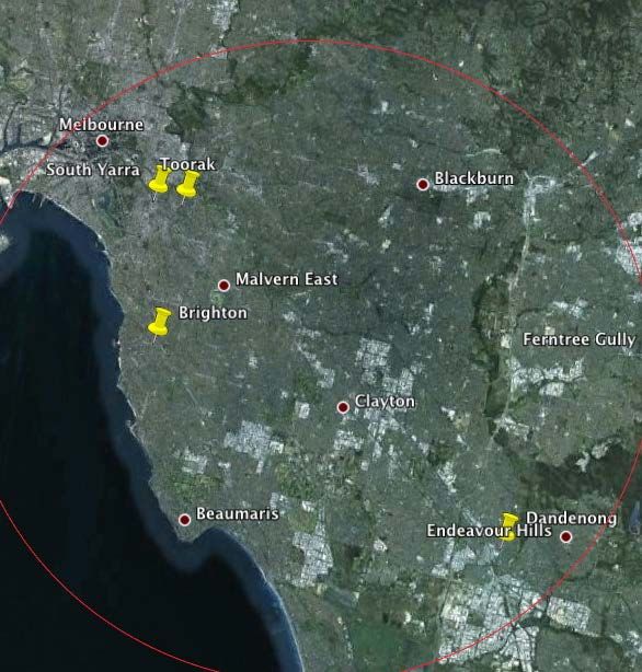
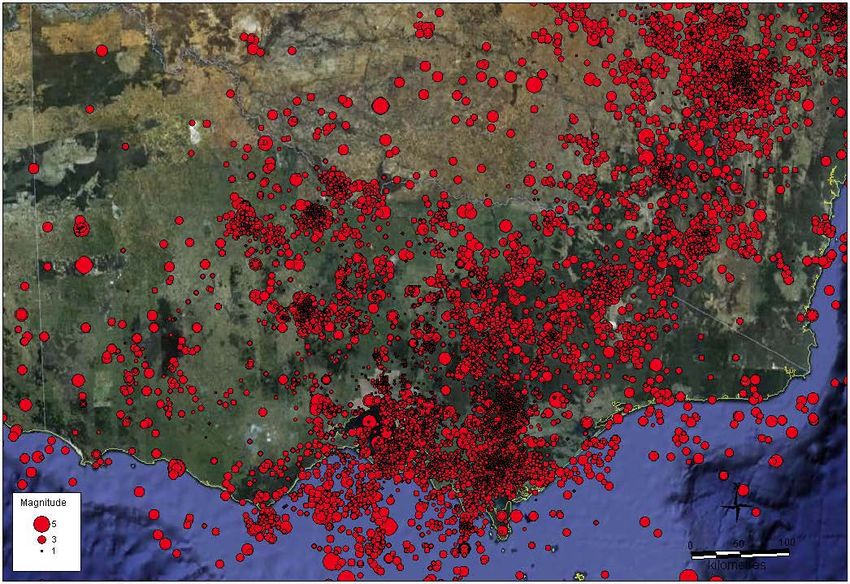
magnitude 5.3, and Gippsland in 1969 magnitude 5.3.
It should be noted that a remarkable belt of approximately 500 volcanoes of Quaternary age
extends across central Victoria from east of Melbourne to southeastern South Australia. Some of
these such as Tower Hill near Warrnambool, or Mt Eccles further west, may have erupted as
recently as 25,000 years or 8,000 years ago respectively. These volcanoes and the independent
large prehistoric earthquakes are symptomatic of currently active tectonism in the local crust. The
Monaro Volcanics near Cooma NSW are an ancient analogue of Victoriaʼs Newer Volcanics.
Victoria boasts the highest density of seismographs of any state or territory in Australia and
Environmental Systems & Services locates about one hundred small earthquakes per year,
excluding aftershocks (~200 aftershocks were recorded in 2009 - see Payne and others, 2010).

Figure 1 Seismicity of Victoria to 2009 (Payne and others, 2010).
Seismicity and seismic hazard in Victoria have been studied by Underwood (1972 & 1973), McCue
(1978), Gibson and others (1981), Wilkie and others (1993, 1994), Gibson (1995), Brown and
Gibson (1998) and Brown and Gibson (2004).
Damage, felt reports, isoseismal maps and hazard
Isoseismal maps for Australian earthquakes are compiled in three atlases by Everingham and
others (1982), Rynn and others (1987) and McCue (1997). Included are maps of 10,1 and 8
Victorian earthquakes respectively.
Brown and Gibson (2004) and the current hazard map of Victoria (in AS1170.4 - 2007) suggest
that the state has moderate levels of seismicity and earthquake hazard, sufficient for earthquake
loading, like wind loading, to be taken into account in normal structural design.
This paper was possible because of the recent publishing on-line by the Australian National Library
of their scanned collection of early Australian newspapers. The site TROVE allows users to correct
the OCR of the scanned images which makes the collection even more valuable as this corrected
text can be searched on-line by all. Examples of the scanned newspapers are documented below.
Lighthouse reports
Victorian lighthouse keepersʼ logbooks containing meteorological and other observations such as
earthquakes were used to draw up the isoseismal maps of the 1903 earthquakes at Warrnambool
(McCue, 1978). These records are kept in Melbourne and researchers must visit Melbourne to
view them which limits their usefulness.
Individual earthquakes
1838 No date, time or location
An article in the South Australian (Tuesday 1st June 1847) about the 1847 earthquake in
Melbourne (listed below), states that this is not the first instance of such an occurrence in this
Province, a shock, heavier than the one now recorded, having been felt in 1838.
1841 04 28 No time or location
The Sydney Monitor and Commercial Advertiser newspaper (Monday 10 May 1841 p2) selectively
extracted stories from Port Phillip papers to 30th April including:

  PORT PHILLIP
  EARTHQUAKE.-Early in the morning of Wednesday last, a smart shock of an earthquake
  was felt in Melbourne and its neighbourhood, being the third similar irritation which has been
  experienced since the formation of the settlement. It is matter of congratulation, that these
  mysterious phenomena have hitherto been so slight as not to occasion the least danger or
  alarm to the inhabitants. Considering the evidently igneous formation of the province, it is
  singular that such convulsions do not more frequently occur.
The Adelaide newspaper The Southern Australian dated 22 June 1841 reports:
   EARTHQUAKE.-The shock of an earthquake was generally felt in New Town and
  various parts of Melbourne, early yesterday morning. This is the second visitation of the
  same description which has been felt since the settlement of the province.
The first of these earlier events (two or three) was that in 1838. There may have been a
subsequent one in 1841, the same source on Wednesday 23 June page 2 quoting from Port Phillip
papers to 13th June 1841 says with no other details: an earthquake caused a disagreeable
sensation in the Church during Divine services.
1847 April 28 at 06:00 UTC No location
  All the papers agree in stating that a shock of an earthquake was experienced at Melbourne,
  of which we extract the following account: At half-past four o'clock, Melbourne was visited
  with one of those singular and at times dreadful phenomena. The shock was rather stiff and
  felt all over the town. In many of the streets some of the houses were severely shaken, and
  the inhabitants became very much alarmed, and ran into the streets. His Honor the resident
  Judge was presiding in the Supreme Court, in the cause of Boyd v. Wilson, when a noise like
  the rumbling of a carriage was heard, and the buildings appeared to rock. The proceedings
  were immediately suspended for a time, when the court was ultimately adjourned. The Flag-
  staff Hill was shaken to its centre, and also the other eminences in and about the town.
   (Burnie Advocate Saturday 3rd May 1947, P4) ABOUT 4 p.m. on Wednesday, April 28, 1847,
  the 13,000 citizens of early Melbourne were conducting their ordinary daily business,
  attending to the wants of up-country pastoralists, loading and unloading the sailing vessels
  from "home" in the Yarra and at Sandridge, and engaging in the numerous other pursuits of a
  thriving colonial town.
  SHORTLY after 4 p.m. the ground began to shake. People stopped in the street; those in
  buildings looked out of the windows, and then there was a mild panic. Someone shouted,
  "It's an earthquake," and those in the streets made for the buildings, while those inside
  started for the open air.
Actually it was not an earthquake; it was an earth tremor, of which Melbourne has had many,
   and of which, one, and perhaps two, had already occurred in the town on the Yarra in the
   time between its settlement in 1834 and 1847. But this was the most severe up to that time,
   and possibly there has not been a more severe one since.
   Naturally such an event could not be ignored by the papers of the day, and on the following
   Saturday, May 1, the Port Phillip "Gazette" devoted three-quarters of a column to the
   occurrence.
   "On Wednesday, between 4 and 5 p.m.," the "Gazette" recorded, "Melbourne was visited by
   an earthquake, which fortunately did no injury to the town. The sensation to those inside was
   that of a heavy body falling on the upper part of their houses. The panic was considerable in
   the Supreme Court, where the case of Taylor and M'Pherson versus Sutherland was being
   tried, and it was at once adjourned.
   "The shock was felt most heavily in Elizabeth street, but it was also quite apparent to persons
   living some miles out of Melbourne.
   "This is the second or third time that earthquakes have been felt in this town, the last having
   occurred in April or May, 1841, at 4 a.m. "
16 September 1855 at 14:50 UTC unknown location
The next Victorian earthquake mentioned in the newspapers retrieved was discussed in a letter
dated Monday 17th September 1855, to the Editor of the Argus by one Ludwig Becker. The
earthquake occurred at 2:50 a.m. that morning and reportedly lasted between 1 and 2.5 minutes.
He reported that in the Union Hotel the shaking was sufficiently intense to awaken nearly all
sleepers. Strong shaking creakings, clatterings and grindings of objects on the surface of the earth
was observed at Collingwood, St Kilda and Windsor. This shaking was preceeded by a
subterranean noise (P wave?) with the same pitch or tone as a heavy omnibus or artillery wagon
passing rapidly.
Interestingly, Becker notes that all the earthquakes recently observed in Melbourne have been
nearly to these points of the compass (horizontal north and south). We may find out more about
these earlier felt earthquakes when additional
newspapers are scanned.
Further information is needed to get a
magnitude and location for this earthquake
but it must have been relatively close to
Melbourne, judging by the descriptions of
shaking and the lack of reports from
Tasmania.
1867 August 09 19:30 UTC W of Melbourne
The Melbourne Argus, 12 August 1867 (from
the Empire of Thursday August 15, 1867, p5)
reported that an earthquake was experienced
in Melbourne at 5:30a.m. on Saturday 10th
August 1867 EST. It lasted about 6 seconds
in Melbourne and shaking extended from
Queenscliffe to Gisborne.
Figure 2 Felt area of the earthquake of 10 August
1867 west of Melbourne. The radius of
perceptibility is at the very least 55km (ML 4.2).

According to the article, the shaking was stronger in Melbourne than earlier ones including that of
September 1855, mentioned above, perhaps because it was closer.
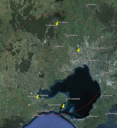
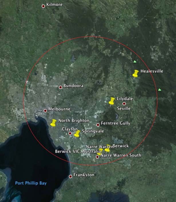
At South Geelong, the ceiling of one house is reported to have fallen down. At Corio Bay, the
shock was felt aboard the barque India, awakening the Captain who thought another boat had run
into them. Windows rattled in Hawthorn and St Kilda whilst at Keilor everyone was awakened.
The felt area delineated in Figure 2 gives an approximate epicentre and magnitude, the earliest
locatable earthquake in Victoria.
07 August 1972 at 19:10 UTC Maldon
Thursday A distinct shock of earthquake was felt here at 10 minutes past 5 this morning (The
Argus, Friday 9th August 1872, P5).
22 July 1893 Bendigo
Bendigo was the supposed epicentre of an earthquake-like shock on Sunday morning according to
the Victorian Barrier Miner. The story was headed The Victorian Earthquake, but subtitled The
effect on the mines. A fall of earth. The newspaper reports that the area over which it was felt was
nearly 2000 square miles (a circle of radius
roughly 40 km corresponding to a magnitude of
3.9). The newspaper then highlights the damage
underground in the Bendigo mines, particularly in
the Confidence Mine.
We infer this was a mine-induced seismic event.
09 July 1904 at 09:27 UTC W of Lilydale
North Brighton was the only place to report minor
damage following the earthquake at 7:27 pm on
Saturday 9th July 1904. According to the
Observatory, it lasted about 20 seconds.
Figure 3 Felt area of the earthquake of 9 July 1904
east of Melbourne (above). The radius of perceptibility
is at the very least 36 km.
The earthquake was felt widely throughout the
eastern portion of the metropolitan area and at
Lilydale, Narre Warren and Springvale according
to the Argus, Monday 11 July 1904. Clocks were
stopped at Berwick. The Healesville and Yarra
Glen Guardian of 16 July 1904 mention that Healesville and Lilydale were thrown into a state of
consternation.
22 September 1904 at 12:00 UTC Korumburra
Korumburra was the likely epicentre of a small earthquake felt by town residents just before 10pm
on Thursday night (The Argus, Saturday 24 September 1904, P16).
This earthquake heralded later shakes for the residents of Korumburra. On 20 June 1969 the
whole of Gippsland was strongly shaken by a magnitude ML 5.3 earthquake. Again on several
occasions in 2011, earthquakes shook Korumburra, one of them felt by thousands of delegates
attending the IUGG meeting in Melbourne in early July.
06 January 1911 at 17:55 UTC SE Melbourne
SMH 7 January 2011, P14: Melbourne, Friday. A
slight earthquake shock was experienced in
Melbourne at 5 minutes to 4 o'clock this morning
and alarmed a great many people in the
southern suburbs. In some cases nervous folk
were awakened by the disturbance which lasted
only a few seconds. They rushed out of doors in
their night clothes but by a great majority the
shock was not noticed. Along the bay front from
Port Melbourne to Brighton the effect seems to
have been most pronounced. The shocks were
said to have been accompanied by a muffled
rumbling noise resembling a distant explosion.
Figure 4 Felt area of the small earthquake near
               th
Melbourne on 7 January 1911 at 3:55a.m. EST. The
distance from Melbourne to Dandenong is ~30 km.
The Argus, Saturday 7 January 1911, P19 noted
that there was a distinct vibration of buildings and rattling of windows in East Melbourne, South
Yarra and Toorak. A following article in the same paper noted that a distinct earthquake was felt at
Dandenong at 5 minutes past 4 a.m., (clocks then were not set using GPS!).
This information is consistent with an earthquake of about magnitude 3.5 located some 10km
southeast of the city of Melbourne.
28 February 1922 at 15:00 UTC Ocean Grove
The year 1922 was quite an active one, felt earthquakes are headlined in newspaper articles right
across southern Australia. One of these earthquakes early on 1st March (EST) shook the city of
Melbourne frightening many of the residents.
Interest in this event seems to have been
Figure 5 Extract from The Argus, 2 March 1922.

Figure 6 Isoseismal Map          Ocean    Grove
earthquake, 28 February 1922.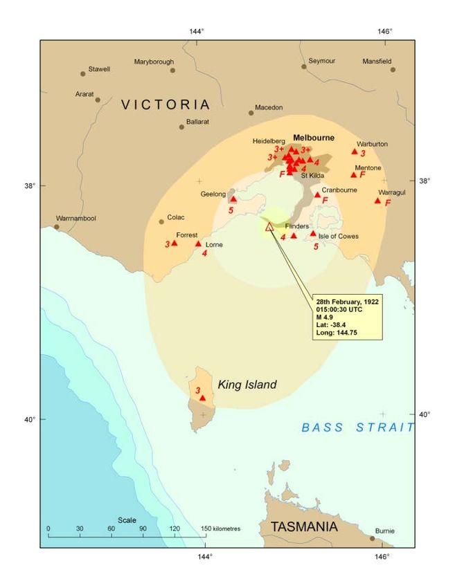
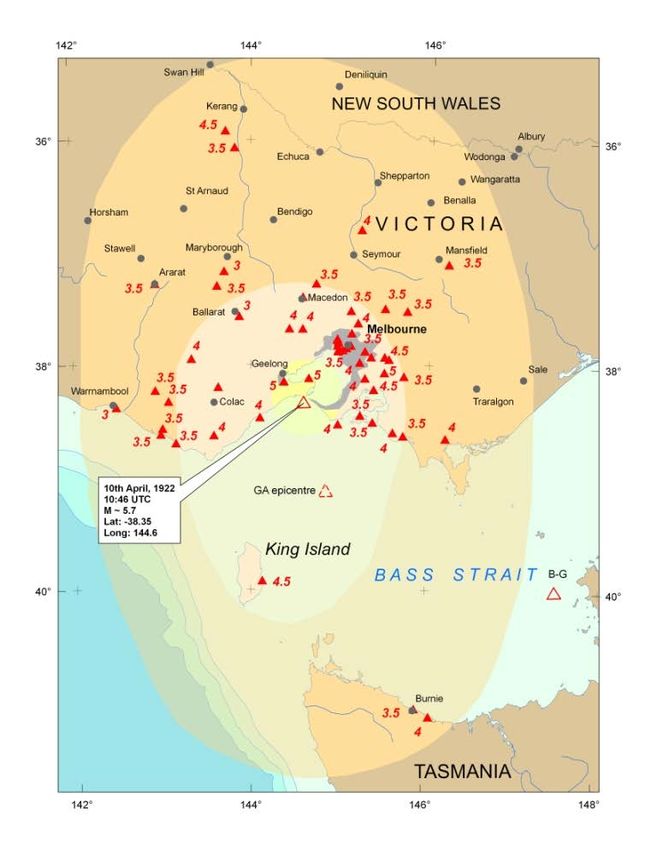
eclipsed by a magnitude Ms 5.2 earthquake in Bass Strait (Everingham and others, 1987) five
weeks later on 10th April which also shook the city, but more strongly. In neither case was damage
substantiated.
Surprisingly no isoseismal map had ever been prepared for either earthquake; the March
earthquake is not in the Geoscience Australia database though it is in Underwoodʼs (1972)
extensive listing of Victorian earthquakes. The epicentre of the April event in Table 1 below (e.g.
Underwood, 1972; Everingham and others, 1987) is quite uncertain – which one to choose for
hazard studies?
The Victorian earthquake at 1am on the 1st March 1922 local time was felt throughout Melbourne
and widely reported from southern Victoria, despite the early hour. Most reports were that the
tremor was short and sharp, mainly the vibration of furniture and rattling of doors and windows. At
Cowes some picture frames propped against a wall fell down, breaking the glass – the only
reported damage. It was recounted during the April earthquake that this March event had also
been felt on King Island (as mentioned by Underwood, 1972) the only point south of the interpreted
epicentre off Cape Otway.
The Argus says it wasnʼt ʻrecordedʼ at the Mt Pleasant
Observatory at Ballarat, an astronomical, not a
seismological, observatory and the logbook of the day
makes no mention that it was felt. The later
earthquake on 10th April was however noted by the
astronomer John Brittain in the logbook: 9pm Earth
tremor.
This earthquake was recorded at Melbourne Observatory, the P wave at 15:00:42, the duration
about one minute, the maximum amplitude only 0.3mm. The epicentre was interpreted by staff
(correctly!) to have been within 100 miles of the observatory.

10 April 1922 at 10:46 UTC Ocean Grove
It was hard to ignore the 10th April
earthquake, so many reports were extracted
by TROVE in a search of 1922 newspapers
and many of them were at odds with an
epicentre in eastern Bass Strait (Everingham
and others, 1987). Ground shaking was felt
at Burnie on the northwest coast of
Tasmania, strongly on King Island, and as far
west as Warrnambool and north to Ivanhoe
in Victoria.
There were more reports of damage than in
the earlier earthquake, both of which were
felt throughout Melbourne; a chimney
reportedly collapsed in Glen Iris and several
places reported that crockery had vibrated off
shelves     and   broken: in      Pakenham,
Portarlington, Cranbourne and East Malvern.
Figure 6 Isoseismal Map        Ocean    Grove
earthquake, 10 April 1922
The isoseismal map shown here supports an epicentre off Ocean Grove in Victoria, not far from
the earlier earthquake discussed above.
Table 1 Earthquake details reported by different sources
Date
Time
UTC
Lat
°S
Long
°E
Mag
Approx
Location
Source
28
02
1922
15:00
39
145
NE
King
Is
Tas
Melbourne
Observatory
15:00:30
38.4
144.75
4.9
Off
Lorne
Vic
This
paper
10
04
1922
10:45
39.3
144.3
N
King
Is
Tas
Melbourne
Observatory
10:47:39
40
147.5
4.8
ML
Flinders
Is
Tas
B-‐G
40
147.5
5.2
Ms
Flinders
Is
Tas
EDG
38.35
144.60
5.7
ML
Off
Lorne
Vic
This
paper
The year was not finished with earthquakes, a slight but very distinct earthquake was experienced
along the Tallangatta Valley on Friday 17th November at 8:30pm local time (The Argus, Monday 20
November 1922, P7). There was also a very local earthquake near Warrnambool on 9th December
mentioned in the introduction above.
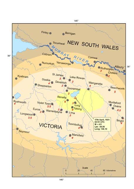
17 April 1931 at 03:51 UTC Benalla
Benalla Victoria seems to have been close to the epicentre of this earthquake that was reported
felt from Rutherglen in the north to Mansfield in the south.
The Argus (18 April 1931) reports that a chimney collapsed in Mr McLeanʼs house in Benalla.
The North Eastern Ensign (Benalla, VIC.) Friday 24 April 1931 Page 3:
EARTH TREMOR AT BENALLA CONSTERNATION AMONG RESIDENTS. SHORTLY before 2 o'clock
on Friday last Benalla suffered from a severe earth tremor which caused much consternation among the
residents. The tremor was accompanied by a rumbling
like thunder, and business people rushed from their
shops while residents left their homes to ascertain the
cause. The earth shook, and in many instances some
weird experiences were felt.
The Governor, Lord Somers, was being entertained by
local returned soldiers at the Benalla Hotel at the time
and those in the dining room felt the tremor. Members
of the staff of the State Electricity Commission who
were busy at their work got a rude awakening when
the desks began to move and Mr. Bob Rennle was
hurled to the floor. They apparently thought that they
would be safer downstairs, and lost no time in gaining
the ground floor.
Several cracks were noticed in the building, particularly
on the ground floor. A large crack was also noticed in
the wall of one of the rooms at the High School, and
several openings were also observed at the Convent.
A rack of furs at the shop of T. J. Davis and Co. were
hurled to the ground and goods in other shops in the
town left the racks.
Figure 7 Isoseismal Map, Benalla earthquake, 17 April
1931.
Mr T. Murrihy of the State Electricity Commission was effecting repairs at the top of an electric light pole
when he felt the shocks and quickly returned to the ground. The feeling was uncanny, and his
experience was an unenviable one. In the private houses crockery rattled on the shelves, furniture
shook and generally everything moved. A stack of motor tyres at the store of the State Electricity
Commission in Bridge Street was knocked down.
The shock was felt around Warrenbayne, Lima, Lurg, St. James, Devenish, Lake Rowan, Goorambat
and other parts. It was severely felt at Tatong and Toombullup where the tremor was preceded by a
heavy rumbling noise that resounded through the gullies. Residents were terrified at the experience
which 'they' declare they do not hope to feel again. An old prospector who was sitting on a box on the
bed of a creek was terrified when the box swayed backwards, and forwards and he narrowly missed
being hurled into the creek. Mr Ern Dickson who is also prospecting in that locality had an unenviable
experience. He was down a 17 foot shaft, when the earth began to sway and he declared he never got
out of anything quicker in his life. A table at the home of Mr Sims moved about six inches and the
crockery in the kitchen of all the houses clinked on the shelves.
The Melbourne Observatory seismograph recorded a small earthquake disturbance from a
comparatively near source on Friday. The first signs on the record occurred at 1h. 51m. 7s. p.m. This
corresponds closely with the time of the tremor in the Benalla district. Close
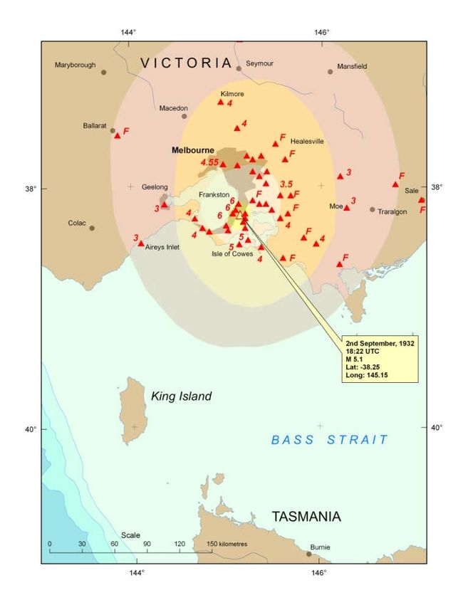
2 September 1932 at 18:22 UTC Mornington
Holmes (1933) was acting government astronomer at the time of this earthquake and he must
have been thrilled receiving hundreds of phone calls from excited residents of southern Victoria
reporting an earthquake. A good physicist, he sent out a questionnaire via The Argus newspaper
and more than 200 people sent responses from which he compiled an isoseismal map.
Unfortunately Holmes did not plot his assigned intensities nor did he bother to include the MM3
isoseismal contour and the questionnaire responses have not been unearthed, so I decided to redo
a map just from the 46 newspaper reports I found, partly to check our method.
The two maps are published below. The epicentres agree very well. The magnitude computed
from the radius of perceptibility is ML 5.1 which is rather larger than the 4.6 quoted in Everingham
and others, 1982. The larger magnitude may be warranted considering the earthquake was
recorded on the Sydney Observatory seismograph (and on the Riverview station as expected). The
value of ML 5.1 is commensurate with Ms 4.6 from Riverview (Everingham and others, 1982).
Figure 8 Comparison of isoseismal maps of the
Mornington earthquake of 2 September 1932 by
McCue (this report) from Newspaper reports alone,
left, and the original by Holmes (1933), right, from
newspaper reports and questionnaires. Holmes did
not plot individual point assessments or an
isoseismal delineating intensity 3, the felt area. The
epicentres are virtually identical, as much as the
intensities allow.Many reports claim there was little or no damage but then, like the Frankston & Somerville Standard of Saturday 10 September 1932 they itemise the damage. EARTHQUAKE. Mt. Eliza was severely shaken by the earthquake last Saturday. Little serious damage was done. At Mt. Eliza store several bottles, tins and other goods were thrown from the shelves. At the public hall a large crack has appeared in the north wall, but as this is only a temporary wall the damage will not cause the committee serious concern. At the Church of St. James the Less the tremor cracked one of the arches. The damage is so serious that repairs will have to be effected. A public appeal was mounted for funds to carry out the repairs on the church, one of the oldest in the State and this work was completed in December the same year. The same paper reported that the earthquake was felt elsewhere: SOMERVILLE - THE EARTH TREMOR. Although no serious damage was done at Somerville by the earth tremor which disturbed a large number of people of southern Victoria on Saturday morning last, a number of minor damage was reported. Walls of several brick buildings were cracked, plaster fell from walls and ceilings, pictures and mirrors fell from the walls and bottles and other articles were thrown from shelves. In one case a washhouse chimney was shattered. It is interesting to note that in quite a number of cases the first impression was that a large motor car or truck had crashed into the house, and in several cases it was thought that horses were either in the house or rubbing against or kicking at the walls. One man on springing out of bed grabbed a gun and cartridges in preparation for a supposed burglar. In comparing impressions most people admitted being more or less alarmed and even terrified. Young children were the least affected, some of them sleeping soundly throughout the disturbance. at Tyabb: Many residents felt the severe earth tremor at 4.20 a.m. last Saturday. Old-time residents state that 40 years ago a similar tremor occurred. (Ed. this might refer to the1892 earthquake off NE Tasmania). 1932 September 19 15:00 UTC Benalla During this search for earthquakes in Victoria in 1932 I came across many reports of a series of earthquake near Benalla in September. The Argus of Wednesday 21 September 1932 reports: EARTH TREMORS AT BENALLA. SLIGHT DAMAGE TO BUILDINGS, BENALLA Tuesday. Benalla residents were startled shortly after 1 o'clock this morning by an earth tremor which shook the town. Most residents had retired and when the shock was felt many left their homes. Those living in Bridge street rushed into the street in their nightclothes to ascertain the cause of the disturbance. In some of the buildings crockery was displaced and articles fell from mantelpieces. The shock ….. resembled a sharp gun report, and numbers of residents thought that a safe was being blown open. Two railway detectives were on duty, believing that a robbery was being perpetrated at the Broken River butter factory, hurried to the factory. The principal buildings affected were the State Savings Bank and Noonan's Commercial Hotel, where large pieces of plaster were broken from the walls. At the Bank of Australasia the blinds in the banking chamber fell. A second tremor was felt at about 3 o'clock, but it was much milder. It was felt also at Tatong, Devenish and Thoona. This is the second tremor which has occurred in Benalla in the last 18 months (see April 1931 earthquake above). 1932 September 21 05:30 UTC Benalla The Argus of Thursday 22 September followed up with:
BENALLA SHAKEN AGAIN. RESIDENTS TERRIFIED. MUCH DAMAGE TO BUILDINGS.
  BENALLA Wednesday - Residents of Benalla were terrified this afternoon by another earth
  tremor following a slight tremor which was felt this morning at half-past 3 o'clock. This was
  followed by a rumbling which lasted about five minutes.
  At half past 3 o'clock this afternoon the second tremor came with terrific force, and it
  resulted in much damage to buildings while many persons were thrown with great force
  from their seats. Probably the worst damage was done at the offices of Mr. R. P. Lewers,
  solicitor. He was seated at his table and narrowly escaped being struck by falling plaster.
  Large bundles of files which were stacked away on racks were scattered about the room. A
  large crack occurred in the walls at the Bank of Australasia where some damage was done
  by the tremor on Monday morning. Pictures were scattered over the floor, and much plaster
  was broken from the walls. Large cracks were observed at the fire brigade station. Most
  damage occurred at the residential quarters where part of the wall shifted for at least two
  inches.
  Plaster was broken in many places at the post-office and a large crack was noticed at the
  Lands office, which adjoins the offices of the Country Roads Board. A chimney fell at the
  residence of Mr. W Say, and a valuable chandelier was broken. Mr. J. Burns who was in a
  cafe at the time of the tremor fainted and was removed outside. Three of the main clocks in
  the town stopped at the moment of the tremor. They were the clocks outside the post-office,
  at the goods shed and at the railway station. The National Bank chambers were strewn with
  broken plaster. In private homes large cracks were noticed in the walls and a considerable
  amount of crockery was broken. At some homes many valuable ornaments fell and were
  broken to pieces.
  The tremor came with more force than the one felt early on Monday morning. Occupants of
  shops in Bridge, Carrier and Nunn streets left the buildings hurriedly and rushed into the
  streets in an excited state.
These September 1932 events are probably part of a nested mainshock/aftershock sequence
within the 1931 earthquake sequence and not an independent set of events. There were
insufficient reports from other towns to compile an isoseismal map so the magnitude is estimated
at ML 4.0 ± 0.3; it did damage so it was bigger than ML 3.5, on the other hand it was not widely felt
like the April 1931 earthquake so was less than ML 4.5.
Discussion
This study has focused only on earthquakes discovered by a search of early scanned newspapers,
there are many more in Underwoodʼs (1972) list to be more carefully analysed at some future time
when the relevant newspapers have been digitised. The relocation of the 1922 Bass Strait events
should improve a re-assessment of earthquake risk in the Melbourne region, especially to the
southwest of the city where there are special structures like the Animal Health Laboratory and oil
and gas storage facilities; this ought to be done as new information comes to hand, or at least at 5
yearly intervals. Improvements in the epicentres of historical earthquakes may be made when
more local newspapers are scanned by the Australian National Library, or other sources such as
diaries are made available to improve the isoseismal maps. There is always scope for
improvement as Underwood (1972) pointed out 40 years ago.
Small earthquakes near the cities are as important as larger rural earthquakes to improve risk
assessments to those cities, especially if the events can be associated with mapped faults.
Human activities are increasingly leading to earthquakes, whether pumping fluids underground for
waste disposal or geothermal reservoir production, filling large reservoirs or mining. Historically,
mining has shown a capacity to induce earthquakes, the hard rock mines of Victoria are no
exception as the event near Bendigo in 1893 shows clearly. More recently fracking operations in
coal rich areas will no doubt provide many more examples. Such operations should be monitored
closely with dense networks of seismographs, and the data made publicly available.
Appendix 1 List of earthquakes discussed in this paper. The small earthquakes for which
isoseismal maps were not produced have been assigned a magnitude of ML 3.5 being a
reasonable balance between being felt only locally, but strongly enough to be noted in a
newspaper, without causing damage.
Date UTC        Time UTC       Latitude      Longitude     Approx.    Comments
                               °S            °E            Mag.
1867 08 10*     19:10          37.8          144.6         4.2        One ceiling is reported to have
                                                                      collapsed at South Geelong
1872 08 07 *    18:50          37.0          144.05        3.5        Maldon, small close local event
1900 03 11      15:45          38.38         142.48        3.5        Warrnambool small close local
1904 07 09      09:27          37.8          145.3         3.8        Clocks were stopped at Berwick
1904 09 22      11:58          38.43         145.83        3.5        Korumburra
1911 01 06      17:55          37.9          145.1         3.5        Near Clayton
1922 02 28      15:00          38.40         144.75        4.9        SE of Ocean Grove
1922 04 10      10:46          38.35         144.60        5.7        South of Ocean Grove
1922 11 17      10:30          36.2          147.2         3.5        Tallangatta      Valley     (Hume
                                                                      Reservoir)
1922 12 09      05:20          38.38         142.48        3.5        Warrnambool
1931 04 17      03:51          36.5          146.1         4.5        Benalla
1932 09 19      15:00          36.5          146.1         4.0        Benalla
1932 09 21      17:00          36.5          146.1         3.5        Benalla
1932 09 02      18:22:32       38.25         145.15        5.1        Mornington
1932 09 21      05:30          36.5          146.1         4.0        Benalla, the largest of         five
                                                                      earthquakes mentioned.

* Prior to the introduction of Eastern Standard Time when time was based on actual longitude. In Melbourne,
at longitude 145°, this would have been 9h 40m ahead of Greenwich (not 10 hours).
Acknowledgments The TROVE resource developed by the Australian National Library is a
treasure indeed for researchers who used to make long trips to the cities to dig out old newspapers
but can now do it all from their office. Rob Underwood searched Victorian newspapers and used
the old Melbourne Observatory logbook to publish a comprehensive list of early earthquakes, the
places where they were felt, and the intensity, but not the magnitude. Cartographer Gayle Young
drew the maps from rough sketches provided by the author.
The manager of Bendigo Observatory, Judith Bailey, searched out the daily logbook of two of the
Benalla earthquakes at the request of the author. My late father Bill and brother David helped
search out data for the 1903 Warrnambool earthquakes. There are too many others who provided
information and help for this study to mention, except for the irrepressible Gary Gibson who was
always ready to discuss and debate the physics of earthquakes in Victoria. Sonja Lenz reviewed
the manuscript but is not responsible for the seismological conclusions.
Appendix 2 Earthquake Poetry
"BASS STRAIT QUAKE."
by A. EVELYN LYNCH. Bonbeach. Published in the Frankston & Somerville Standard Saturday 24
September 1932, page 5 following the Mornington earthquake.
There's a dawn I shall remember,
August had just said "How do to September”.
Suddenly a loud rumbling like heavy thunder,
Startled Peninsula folk from their slumber.
Houses were quaking on their foundations,
And quivering beds gave queasy sensations.
Astronomers are seeking the cause of commotion,
Deeming the tremor began in the ocean.
Maybe Earth developed a pain in her "tummy,"
Her quivering and groaning made us all feel rummy.
If attacked there again and not stand the strain,
She may pop with a terrific explosion.
Then we'll be drying our tears in a new strathasphere,
Or fleeing from sharks in the ocean.
References
AS1170.4-2007. Minimum Design Loads on Structures Part 4: Earthquake Loads. Standards
Australia. 64pp.
Brown, A., and Gibson, G., 1998. Earthquake Hazard in Victoria. Proc. Australian Earthquake
Engineering Society, Perth. (abstract only).
Brown, A., and Gibson, G., 2004. A multi-tiered earthquake hazard model for Australia.
Tectonophysics, 390, pp. 25-43.
Burke-Gaffney, T.N., 1951. Seismicity of Australia. J and Proc. Roy. Soc., NSW, Vol LXXXV, pp.
47-52.
Everingham, I B, and Tilbury, L, 1972. Information on Western Australian earthquakes 1849-1960.
Royal Society of Western Australia. Journal, v. 55(3), November, pp. 90-96.
Everingham, I.B., McEwin, A.J., and Denham, D., 1982. Atlas of isoseismal maps of Australian
earthquakes. Bureau of Mineral Resources, Australia, Bulletin 214.
Everingham, I. B., Denham, D., and Greenhalgh, S.A., 1987. Surface-wave magnitudes of some
early Australian earthquakes. BMR Journal of Australian Geology and Geophysics 10(3), pp.
253-259.
Gibson, G., 1995. Earthquakes, Geological Hazards in Introducing Victorian Geology Ed.
Cochrane, Quick and Spencer-Jones. Geol. Soc. Aust. (Victorian Division), pp. 266-270.
Gibson, G., Wesson, V., and Cuthbertson, R., 1981. Seismicity of Victoria to 1980, J Geol. Soc.
Aust., 28, pp. 341-356.
Hills, E.S., 1963. Elements of Structural Geology. Chapman and Hall, 502pp. Great Britain.
Holmes, W.M. 1933. The Mornington earth tremor of 3rd September 1932. Transactions of the
Royal Society of Victoria, 45 (2), pp. 150-151.
McCue, K.F., 1978. The value of historical records - the Warrnambool earthquake of July 1903.
Journal Royal Society of Victoria, 90 (2), pp. 245-250.
McCue, K.F., 1980. Magnitudes of some early earthquakes in south-eastern Australia. Search,
11(3), pp. 78-80.McCue, K.F., 1978. Seismic Risk in Eastern Australia. University of South Australia, Report ADP
153 (unpubl.)
McCue, K.F., 1996 (compiler) Atlas of Isoseismal Maps of Australian Earthquakes Part 3. AGSO
Record 1996/19.
McEwin, A.J., Underwood, R., Denham, D 1976. Earthquake risk in Australia. BMR Journal of
Australian Geology and Geophysics 1(1), pp. 15-21.
McPherson, A., Clark, D., Cupper, M., Collins, C.D.N., and Nelson, G., 2012. The Cadell Fault: a
record of long-term fault behaviour in south-eastern Australia. Australian Regolith and Clays
Conference Mildura, 7-10 February 2012.
Payne, C., Pascale, A., Peck, W., and Lowe, C., 2010 – ES&S Seismic Network Report, 2009.
http://www.aees.org.au/Articles/Payne_ESS-SNR_2009.pdf.
Rynn, J.M.W., Denham, D., Grenhalgh, S., Jones, T., Gregson, P.J., McCue, K. and Smith, R.S.,
1987. Atlas of isoseismal maps of Australian earthquakes. Bureau of Mineral Resources,
Australia, Bulletin 222.
Shirley, J.E., 1980. Tasmanian Seismicity – Natural and Reservoir-Induced. Bull. Seism. Soc.
Amer., 70, 6, pp. 2203-2220.
Twidale, C.R., and Stehbens, R., 1978. The Changing Surface of the Earth. Thomas Nelson (Aust).
120pp. Hong Kong.
Underwood, R., 1972. Studies of Victorian Seismicity, Proc. Royal Soc. Vic, 85, 27-48.
Underwood, R., 1973. Progress Report on Seismic Zoning in Australia. BMR Bulletin 164, pp. 61-
66.
Wilkie, J., G. Gibson and V. Wesson, 1993: Application and extension of the ML earthquake
magnitude scale in the Victoria region, AGSO Journal Aust. Geol. and Geoph., 14, 1, pp. 35-
46.
Wilkie, J., G. Gibson and V. Wesson, 1994. Richter magnitudes and site corrections using vertical
component seismographs, Australian Journal of Earth Sciences, 41, 3, pp. 221-228.
Wilkie, J., G. Gibson and V. Wesson, 1994. Earthquake duration magnitudes in southeast
Australia, accounting for site, seismograph and source, AGSO Journal, 15, 4, pp. 469-474.
Wilkie, J., and G. Gibson, 1994. Estimation of seismic quality factor Q for Victoria, Australia, AGSO
Journal, 15, 4, pp. 511-517.
You can also read