The Kashmir Earthquake of October 8, 2005: Impacts in Pakistan
←
→
Page content transcription
If your browser does not render page correctly, please read the page content below
EERI Special Earthquake Report — February 2006
Learning from Earthquakes
The Kashmir Earthquake of October 8, 2005: Impacts in Pakistan
An EERI reconnaissance team House. This report summarizes the at 87,350, although it is estimated
comprising Saif Hussain, Coffman salient portions of the information that the death toll could reach over
Engineers, Inc., Encino, California; gathered during the visit. 100,000. Approximately 138,000
Ahmed Nisar, MMI Engineering, were injured and over 3.5 million
The publication of this report is fund-
Oakland, California; Bijan Khazai, rendered homeless. According to
ed by EERI’s Learning from Earth-
Columbia University, Earth Institute; government figures, 19,000 children
quakes Program, under National
and Grant Dellow, Institute of Nu- died in the earthquake, most of
Science Foundation Grant #CMS-
clear and Geological Sciences, them in widespread collapses of
0131895. (Note: Additional photos
New Zealand, visited Pakistan school buildings. The earthquake
from the reconnaissance team can be
November 13-20, 2005. During the affected more than 500,000 families.
viewed at www.eeri.org/google.)
visit, the team was hosted by the In addition, approximately 250,000
North West Frontier Province farm animals died due to collapse of
(NWFP) University of Engineering Introduction stone barns, and more than 500,000
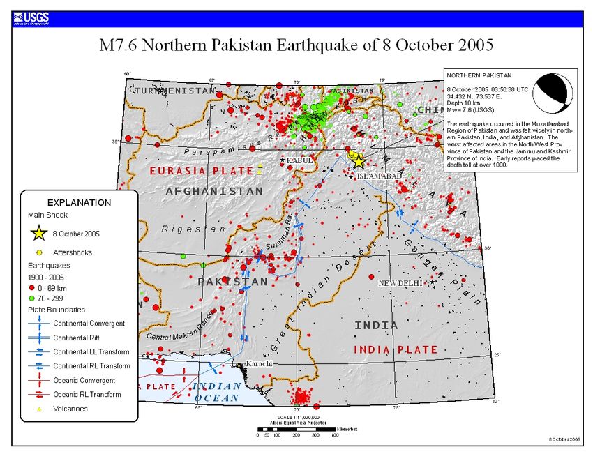
and Technology (UET) and spent On October 8, 2005, at 8:50 a.m. lo- large animals required immediate
four days in the earthquake-affected cal time, a magnitude Mw = 7.6 earth- shelter from the harsh winter.
areas of northern Pakistan. NWFP quake struck the Himalayan region of
UET staff included Dr. Qaisar Ali, northern Pakistan and Kashmir. The It is estimated that more than
Syed M. Ali, and Mr. Mansoor earthquake epicenter was located ap- 780,000 buildings were either de-
Khan. The trip included a helicop- proximately 19 km north northeast of stroyed or damaged beyond repair,
ter survey of the area courtesy of the city of Muzaffarabad, the capital and many more were rendered
the Pakistan Army. The team also of the Pakistani-administered part unusable for extended periods of
attended a two-day international of Kashmir, known as Azad Jammu time. Out of these, approximately
conference on the earthquake Kashmir (AJK). 17,000 school buildings and most
organized by the NWFP UET in major hospitals close to the epicen-
Islamabad and met with the Prime The Pakistani government’s official ter were destroyed or severely dam-
Minister of Pakistan at the PM death toll as of November 2005 stood aged. Lifelines were adversely af-
fected, especially the numerous
vital roads and highways that were
closed by landslides and bridge
failures. Several areas remained cut
off via land routes even three
months after the main event. Power,
water supply, and telecommunica-
tion services were down for varying
lengths of time, although in most
areas services were restored within
a few weeks.
Massive landsliding was a particular
feature of this event. A very dense,
high-frequency band of landslides
was triggered along the fault rup-
ture trace in the midslope areas;
however, it quickly dissipated with
distance away from the fault rupture
zone. Almost all landslides were
shallow, disaggregated slides, with
two of them larger than 0.1 km2.
Due to the generally arid landscape,
liquefaction was not observed or
Figure 1. General location map, Mw = 7.6 Kashmir Earthquake reported by others.
EERI Special Earthquake Report — February 2006
Muzaffarabad suffered great dam-
age (IX-X on MMI scale), and the
city of Balakot was almost totally
destroyed (X on MMI scale). The
distribution of subsequent after-
shocks, in the Balakot, Batagram,
Allai, and Beshram Qila areas,
suggests that the fault rupture
extended in the NW direction.
The surface trace of the causative
fault can be interpreted from the
map of ground displacements from
radar amplitude measurements
(COMET 2005). The surface ex-
pression of the fault can also be
clearly detected in images of lithol-
ogy change from Landsat data. A
3-D relief projection shows the ex-
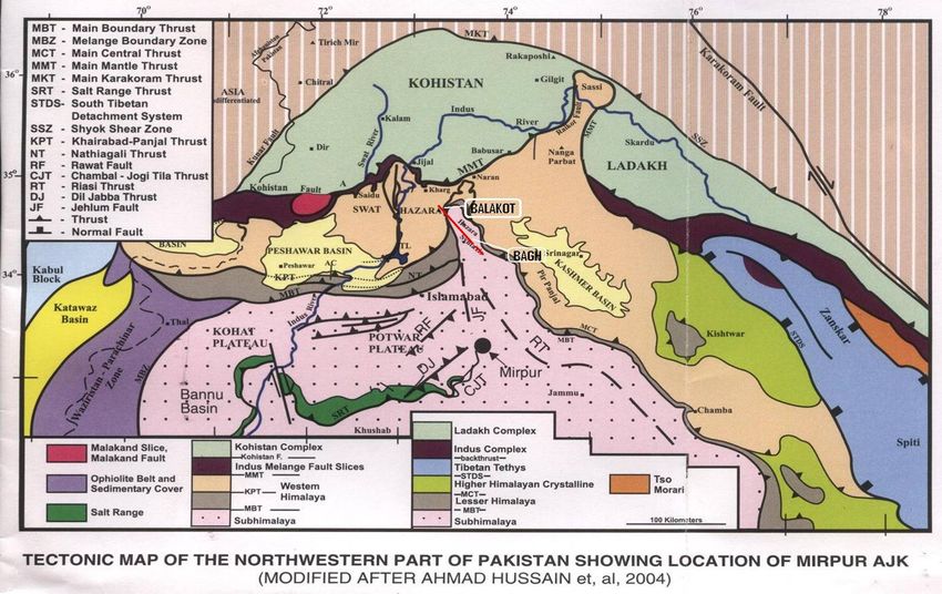
Figure 2. Tectonic map of northwestern Pakistan (Hussain et al. 2004). pression of this fault not only in the
surface geology, but also in the
Seismotectonics with the rupture zone. Outside the surface geomorphology. Figure 3
narrow (5-10 km) width of the rupture shows ground deformation that ap-
Seismic activity in South Asia is a zone, the signs of damage appeared
direct result of the collision of the pears to be tectonic in nature, pos-
to be fairly minor. While there was sibly but not necessarily associated
Indian and the Eurasian plates, which damage in more distant locations
results from the northwestern motion with the main rupture trace.
such as Abbotabad (35 km from
of the Indian Plate at the rate of rupture zone), Islamabad (64 km),
4-5 cm per year (Figure 1). The re- Because of the lack of instrumen-
and Lahore (> 250 km distant), it can tation, there are no strong motion
sulting collision has fractured the In- be attributed to local site effects or
dian plate into several slices beneath records within the zone of intense
poor construction rather than direct shaking. Observational data and
the Kashmir Basin and is known as intense shaking from the earthquake.
the Indus-Kohistan seismic zone reports from locals suggest a
Within the rupture zone, the city of
(Seeber and Armbruster 1979).
The earthquake occurred within the
Hazara-Kashmir syntaxis of the Him-
alayan fold belt. The main identified
feature in this zone is the Balakot-
Bagh fault (Hussain 2005), which is
the likely source of the earthquake
(Figure 2). The fault plane solution
shows a strike of 338 degrees, dip-
ping about 50 degrees in the N-NE
direction near the surface with a
more gentle dip at depth. Net slip for
this event, estimated by field survey
and radar range changes, is 4.2 ±
0.5m, with a maximum slip of ap-
proximately 5m. The reported focal
depth for this event ranges from
13km (MSSP), to 20km (USGS), to
26km (IGS).
The intensity distribution estimated
and interpreted by the Pakistan Geo-
logical Survey is closely associated Figure 3. Localized zone of uplift.
EERI Special Earthquake Report — February 2006

                                                                                       Shallow, Disrupted Landslides:
                                                                                       Ubiquitous shallow landslides and
                                                                                       rock falls on steep natural slopes
                                                                                       and in steep road cuts were initiated
                                                                                       during the earthquake. They posed
                                                                                       the largest threat to mountain roads
    Figure 4.
                                                                                       and structures at slope bases.
    Landslide
                                                                                       Even though relatively small in
concentration
                                                                                       scale, the shallow landslides had a
   along mid-
                                                                                       pervasive nature that significantly
      slopes.
                                                                                       contributed to damage caused by
                                                                                       the earthquake, particularly in the
                                                                                       lower slopes inhabited by large
                                                                                       human populations. Many of these
                                                                                       slopes, such as along the river
                                                                                       terrace in Muzaffarabad, continue
                                                                                       to pose a major hazard due to the
                                                                                       presence of large tension cracks as
                                                                                       far back as 10 m, especially since
strong vertical component and            with aspects in the fault-normal              emergency shelters have been set
30-45 seconds of strong shaking.         direction, showing strong indication          up in such areas.
Strong motion records in Abbota-         of rupture directivity effects. Other
bad (35 km from rupture zone),           effects such as topographic ridge top         The shallow landslides were not
Murree (34 km), and Nilore (54 km)       amplification were widely observed,           associated with specific geologic
show maximum horizontal peak             especially in the case of elongated           units and/or type of slopes. They
ground accelerations (PGA) of            ridges with steep slopes. In some             were as deep as the root zone of
0.231g, 0.078g and 0.026g, re-           cases, where the ground motion                the vegetative cover, anywhere
spectively; and vertical PGAs of         was perpendicular to the ridge axis,          from several decimeters to a meter
0.087g, 0.069g and 0.03g, re-            damage was noted on one side of the           deep, and consisted of dry, highly
spectively (MAEC, 2005). Maxi-           ridge slope, but not on the other. This       disaggregated and fractured
mum horizontal PGA was 0.16g at          variability may be due to active road-        material that cascaded downslope
the crest and 0.1g at the base of        building that created a weakness              to flatter areas at or near the base
Tarbela Dam (located approximate-        in the direction of total collapse, in        of steep slopes.
ly 78 km distant), and 0.1g at the       addition to the structural/geologic
downstream toe of the Mangla Dam         component, thereby adding to the              Deep-Seated Landslides: Deep-
(approximately 90 km distant) were       greater susceptibility of one of these
                                                                                       seated landslides were far less
also reported (Ilyas 2005).              slopes.
                                                                                       numerous than shallow slides. The

Landslides
Landslide concentrations along the
rupture zone were very high, but
quickly dissipated within as little as                                                                           Figure 5.
2 km of the surface projection of                                                                                Note mas-
the fault. During the aerial recon-                                                                              sive land-
naissance of the affected area,                                                                                  slide in the
landslide damage appeared to be                                                                                  background,
most severe on the hanging wall,                                                                                 completely
with relatively low concentrations                                                                               collapsed
on the footwall side. A very high                                                                                structures
concentration of large and small                                                                                 in the fore-
landslides was observed in the                                                                                   ground with
mid-slope area along the surface                                                                                 only roofs
projection of the fault (Figure 4).                                                                              intact.

The number of slope failures also
increased significantly along slopes
EERI Special Earthquake Report — February 2006
two most significant ones (larger
than 0.1 square km) were noted in
Muzaffarabad and in the Jhelum
Valley. The former, located north of
Muzaffarabad, occurred in a dolo-
mitic limestone unit that had pre-
viously failed and dammed the
Neelum River for a day. There was
evidence of a pre-existing landslide
in this formation that had also
dammed the river. The enormous,
deep-seated failure in the Jhelum
Valley was 36 km southeast of the
epicenter and within 3 km of the
surface projection of the fault in a
jointed sandstone unit. The land-
slide was over 1 km wide and the
distance between the top of the slip
surface and the toe of the debris
was more than 2 km. (See the spe-
cial earthquake report insert in the
December 2005 EERI Newsletter
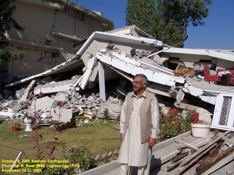
for further discussion of this slide.) Figure 6. Man in front of his sister’s house in Muzaffarabad that collapsed and
The landslide debris created a dam killed her. Masonry bearing wall construction.
that blocked the convergence of two
small rivers at the bottom of the
valley. vial deposits along the Neelum and Bearing Wall Construction: Most
Jhelum rivers. Damage in Balakot of the buildings in the affected area
Rock Falls: Rock falls involving was directly related to fault rupture. are of nonengineered unreinforced
large rocks or boulders were com- In Abbotabad, damage was due to masonry (URM) wall construction.
mon and resulted in considerable local site response in the Canton- The typical structure consists of
damage and disruption to road- ment area that was reportedly de- one or two stories of unreinforced
ways, structures, and communities. veloped on former marshland. Sev- stone, solid brick or solid concrete
Many such slides, triggered by eral other towns located along the block masonry-bearing walls with
frequent aftershocks, resulted in rupture zone (Bagh to Batagram) reinforced concrete floors. Roof
significant fatalities. also suffered significant damage to structures are flat or pitched. Flat
their building stock. The widely roofs in smaller towns and villages
photographed collapse of the high- consist of wood (non-machined)
Structures rise Margala Towers in Islamabad, beams and straw-reinforced mud
Most building damage resulted from located over 80 km from the epi- slabs and occasionally lightly rein-
ground shaking, though a large center, may have been due to con- forced concrete slabs (“Tayyar
number of buildings located mostly struction-related issues. Chath”) or GI (galvanized iron)
on or near slopes were destroyed sheets. Larger towns have build-
by ground failure due to landsliding A helicopter survey revealed that ings built of reinforced concrete
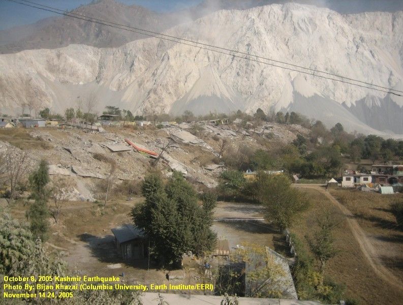
or subsidence (Figure 5). The larg- a large number of buildings in the slab roofs. Pitched roof construc-
est concentration of destroyed or more rural, mountainous areas— tion, gabled, with or without hips,
damaged buildings was in Muzaf- perhaps as much as 50% in areas is framed with wood or light steel
farabad and Balakot. Other cities proximate to the fault rupture— trusses with corrugated sheet metal
such as Bagh and Rawlakot also were destroyed or severely dam- roofing. Tiled roofs can also be
had significant damage, but were aged. These were mostly farm- found in this region. The smaller
not visited by the EERI team due to houses belonging to migratory and villages also contain adobe struc-
limited time. It is estimated that in non-migratory mountain slope farm- tures that, as expected, performed
Muzaffarabad, 30-50% of the build- ers. The government of Pakistan poorly in the earthquake.
ings were either destroyed or badly estimates that more than 80% of
damaged in the main event. Major the total destroyed buildings were Foundations are constructed mostly
damage concentrations in Muzaffar- located in rural regions. of stones or bricks bearing on na-
abad were in areas of deeper allu- tive soils about two to three feet
EERI Special Earthquake Report — February 2006
strength, weak mortar, and lack of rely on emergency medical aid from
seismic detailing. In general, fired- the military and NGOs like the Red
clay brick masonry wall buildings Crescent/Red Cross as they mobil-
appear to have performed better than ized for the rescue effort 24 hours
the other types of wall construction. after the earthquake.
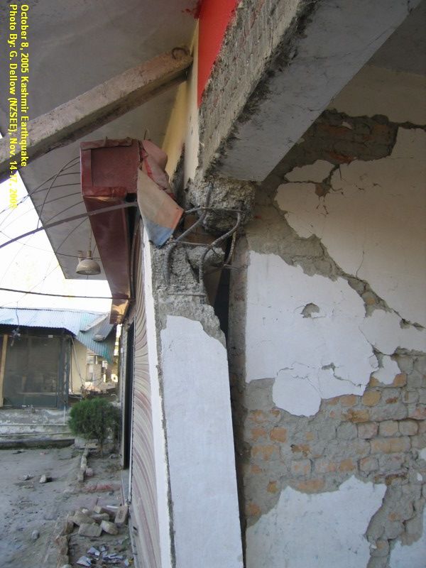
Framed Construction: A small A major hospital in Abbotabad, the
percentage of buildings in the area, Ayub Medical College, was a criti-
mostly larger multistory buildings cal care facility lost due to lack
in the larger towns, are nonductile of a proper post-earthquake
reinforced concrete stick frame assessment process. The hospital
construction with nonstructural in- was evacuated and patients re-
fill block or brick walls with plaster located to the front yard of the facili-
finish (Figure 7). The floors are ty due to mistaken categorization
mostly of beam and slab construc- of nonstructural damage as major
tion supported by columns resting on structural damage. This resulted
pad foundations. There is no lateral in significant disruption of hospital
force-resisting system, and it is operations. A similar problem oc-
mostly infill walls that provide some curred with the Abbas Medical Insti-
amount of lateral strength and stiff- tute in Muzaffarabad.
Figure 7. Failed column at a store-
ness. A number of buildings, some of
front showing three aspects of dam-
them three or four stories tall, were The issue of post-earthquake safety
age: (1) column failure; (2) soft/
seen resting entirely on “nonstruc- assessment is a significant one
weak story at storefront; (3) infill
tural” infill walls while the columns even for ordinary buildings. Due to
walls preventing total collapse of
had failed just below the first ele- lack of qualified personnel, a num-
building.
vated floor. Many soft/weak story ber of homeowners uncertain
failures were observed in mixed use about the safety of their homes
below grade and 18 to 24 inches
multistory buildings with open store- temporarily relocated to distant
wide. The only steel reinforcing
fronts at the first/ground floor level towns or tents, even though their
found in most of the bearing wall
and walled office/residential space in homes did not appear to have any
construction is in lintels (window or
the upper stories. significant damage.
door headers), and normally con-
sists of four #4 bars in a 9 x 9 con-
Schools and Hospitals: Virtually all Lifelines
crete beam with stirrups or ties at 9-
school buildings are government-built
12 inch spacing. Typically, no bond Transportation: Road closures
and owned, and every community
beams are part of the wall and no completely cut off land access to
has an elementary school, even the
positive ties exist between the walls the Jhelum, Neelum, and Kaghan
remote villages. Anecdotal evidence
and the floors/roofs. The perfor- valleys. Landslides were the pre-
suggests catastrophic damage to a
mance of the URM wall buildings dominant cause of the closures.
much higher proportion of public
in the earthquake was varied and The problem of slope failures along
schools than nongovernmental build-
seems to have depended on factors road cuts was exacerbated by a
ings in the same areas. Poor quality
such as redundancy in structural road-building process that uses ex-
of construction and lack of seismic
walls and quality of materials and plosives in weak structures and
design has been faulted in these
construction (Figure 6). cuts into toes of pre-existing land-
building collapses. Although most
school buildings collapsed totally or slides. Many road closures were
In areas of strong shaking, most due to shallow disaggregated slides
partially, many schools were open
stone masonry-bearing wall struc- and rock falls that rarely caused the
and functioning with the classes be-
tures collapsed or suffered severe complete loss of the roadway
ing held in the adjacent school yard.
damage. A majority of these struc- bench. However, the unstable na-
tures were constructed of non- ture of the debris and the presence
Many hospitals in the region also
dressed round stones with mud or of disrupted rock masses along the
suffered severe damage or collapsed.
weak cement mortar. The weak- slopes above the roadway created
Of the two main hospitals in Muzaffar-
ness of the mortar was clearly evi- ongoing challenges in clearing and
abad, the main Combined Military
dent; the mortar would crumble opening the roads.
Hospital (CMH) totally collapsed, kill-
even when manipulated with bare
ing or injuring many patients and
hands. Issues with concrete block The problem of road closures was
workers. Residents of the city had to
construction were poor block so significant that the army dedi-
EERI Special Earthquake Report — February 2006
There was no damage to cables or
cable anchorage, except in one
bridge where the cables were frac-
tured after the collapse of the tow-
ers due to a fire in an adjacent
store containing gas cylinders.
Figure 8.
Shearing fail-
Reinforced concrete bridges in the
ure of bridge
area typically consisted of single or
tower foun-
multiple span reinforced concrete
dation, Bala-
decks supported on reinforced con-
kot.
crete columns or pier walls. Dam-
age to reinforced concrete bridges
ranged from sliding of deck or sig-
nificant movement of wing walls.
Water Supply: Private water stor-
age in the form of roof-mounted
storage tanks is prevalent in the
area. In the earthquake zones,
cated 12 engineer battalions to bridges. The former consist of a wood many overhead water tanks shifted
open roads. Due to the army’s ex- deck supported on steel girders sus- or collapsed. Municipal water sup-
tensive experience with road build- pended by steel cables on either side ply to Muzaffarabad comes from
ing, and the availability of skilled of the deck. The cables are supported the River Neelum. River water
builders in the mountain communi- by a tower at each end and anchored is lifted from six intake lines and
ties after many years of building the in a concrete anchor block. In addi- treated in a series of rapid sand
Karakoram Highway, the opening tion, the deck is prevented against filters and clarifiers. Damage to
and reconstruction of roads was sway by cables attached to a longitu- this water system ranged from
handled efficiently. At the time of the dinal cable on each side below the damage to clarifier baffles, motor
reconnaissance, the Jhelum Valley deck elevation and anchored in con- control units, and distribution piping
Road, the Kaghan Valley Road, and crete anchor blocks. The suspension in some areas. With help from
the Karakuram Highway had been bridges are typically for pedestrian UNICEF, the system was repaired
cleared and opened. The Neelum use, with some allowing vehicular fairly quickly—untreated water
Valley Road, the only other major traffic. Damage to suspension bridges was returned within five days, and
road in the affected area, had ranged from shearing of the tower treated water was available ten
only a 5-km stretch remaining to be foundation (Figure 8) to complete days following the earthquake.
cleared. While most major roads collapse of the towers (Figure 9).
have been reopened, there is a
vast network of tertiary roads serv-
ing the mountain community in the
higher elevations. Many of these
roads remain closed, cutting off
populations that did not even ex-
perience the direct effects of the
earthquake and hampering relief
efforts.
Several bridges were damaged, es-
pecially within the Jhelum Valley
and in Balakot. However, a number
of bridges did not suffer much dam-
age and were open to traffic. Within
the earthquake-affected zone, the
most prevalent bridge type was
either suspension bridges or rein-
forced concrete multiple span
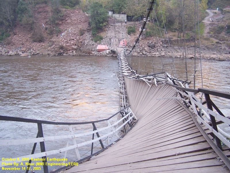
Figure 9. Collapsed suspension bridge, Jhelum Valley.
EERI Special Earthquake Report — February 2006
In smaller villages and hamlets, given a great deal of attention in ur- ease, and severe malnutrition. The
water comes from private ground ban planning and policy decisions, early days of the disaster response
water wells or natural streams. and seismic design does not appear were marked by uncoordinated ef-
In one case, a hamlet located be- to be high priority, except for major or forts among a whole host of organi-
tween Mansehra and Ghari Habib- high profile projects. zations involved in relief work.
ullah experienced a significant drop There was little information on who
in water elevation in its wells two In meetings with public officials, it be- was doing what and little oversight.
weeks after the earthquake, and came apparent that there was no A coordinating structure was later
the locals reported high turbidity. code enforcement in the region. It created by the government under
appears that most practicing engi- the Federal Relief Commission
Other Lifelines: While land tele- neers in major urban areas use the (FRC) and the ERRA (Earthquake
phone service was not operational, UBC for building design. The use of Relief and Rehabilitation Authority)
new wireless telecommunication ACI codes and British Standards is to coordinate activities with other
towers were erected within days of also common. In a meeting of the international agencies and NGOs.
the earthquake, and communica- EERI team with the Prime Minister According to the World Bank, the
tions were fully restored relatively of Pakistan, it was mentioned that relief work will cost $2 billion. Ac-
rapidly after that. the development of a proper national cording to another estimate, approx-
building code with appropriate seis- imately 0.5 million tents, 3.5 million
Electricity to the Muzaffarabad area mic design provisions had been out- blankets, 60,000 tons of food, and
is supplied from Mangla Dam and sourced to local consultants, and 3,000 tons of medicine have been
from a local 30 megawatt Jhangra they had been given one month to required.
hydroelectric power plant. Power produce such a document. A draft of
loss in Muzaffarabad was due to this code document was not available Shelter strategy was organized
fallen transformers and broken for review at the time this report was around three populations: people
lines. Electricity was fully restored written. Many people have already who lived in houses in the lower
to most of the city in five to six started reconstruction without building elevations, people living in higher
days. Main transmission towers codes or enforcement. elevations who could come to the
fared very well, with no damage to lower elevations, and people living
the towers even in the area of in- Response and Recovery in inaccessible snowline areas
tense shaking. In one case, how- (5,000-7,000 feet). People in the
ever, a landslide damaged the The earthquake affected a population former two categories were pro-
transmission line near Balakot. of approximately 3.5 million people vided with tented villages man-
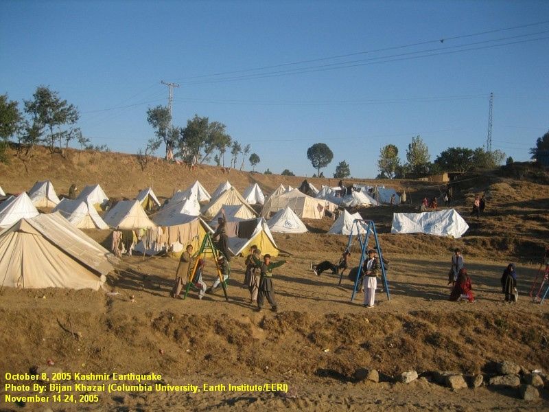
either directly or indirectly, and the aged by some agency (Figure 10).
Heating is provided from either logistics of administering aid and re- People in the last category were
electricity or LPG. There are no lief efforts have been extremely not compelled to descend to the
natural gas supply lines to Muzaf- daunting. In addition to the stagger- tented villages. Survivors are being
farabad. ing numbers of deaths, the human taught to build transitional shelter
cost includes amputees, orphans, un- using material from retrieved debris,
hygienic conditions resulting in dis-
Seismic Planning Provi-
sions and Building Codes
Even though Pakistan has desig-
nated seismic zones, the area that
Figure 10.
suffered in the earthquake was
Children in
either not classified or was deemed
makeshift play-
to be Zone 2 (equivalent to UBC
ground in front
Zone 2: low to moderate risk). The
of their tent
major cities of Peshawar (Zone 2),
camp. White
Islamabad (Zone 2), Karachi (Zone
plastic sheets
2) and Quetta (Zone 4) had been
have been add-
classified, but not in a way that
ed to the tents
agrees with those given in Appen-
to protect
dix III of Chapter 16 of the 1997
against rain.
UBC, where Islamabad, Peshawar,
and Karachi are all classified as
Zone 4. Seismic hazard is not
EERI Special Earthquake Report — February 2006

  reinforced with locally available              far away as Islamabad. Students,            ing the disaster). It is estimated that
  materials such as timber and hay               parents, and teachers want the              approximately 400,000 houses will
  in addition to the corrugated gal-             schools to reopen, but few schools          be reconstructed by the govern-
  vanized iron (CGI) sheets provided             in affected areas are functional.           ment. Numerous groups and indiv-
  to them.                                       Some tent schools have been                 iduals are presenting ideas on
                                                 opened, and gradually life is return-       earthquake-resistant construction,
  Recycling CGI sheet roofs from de-             ing to normal. Trauma counseling            but they are apparently not being
  stroyed homes has been problem-                for the students will be necessary for      coordinated properly at the pres-
  atic because of people’s preference            quite some time.                            ent time. Organizations interested in
  for using the retrieved material for                                                       constructing houses will have to
  their permanent structures later on            The earthquake destroyed 782 health         follow the standards and proce-
  and not for temporary structures.              institutions, so the area was nearly        dures set forth and coordinated by
  Outlets for provision of construction          devoid of any type of health facility       the Earthquake Reconstruction and
  material are being devised. The                after the earthquake. Despite the           Rehabilitation Authority (ERRA),
  government has created an incen-               base and field hospitals that worked        when those become available.
  tive for people to use their own               around the clock, it was difficult to get
  materials by giving free CGI sheets            the right kind of medical teams and         According to a World Bank esti-
  to people who use half of their own            equipment to the affected areas due         mate, $3.5 billion will be needed for
  material. NGOs working in Neelum               to the difficult terrain. The earthquake    reconstruction and rehabilitation.
  Valley noted the problem of people             also badly affected maternal health
  carrying heavy GI sheets, weighing             because most traditional birth              References
  8-9 kg each, to higher altitudes. Al-          attendants either died or moved to
  ternative lightweight materials such           safer places. Pregnant women will           Center for the Observation and
  as plastic sheets have been sug-               not get needed pre- and post-natal          Modeling of Earthquakes and
  gested, but their inability to carry           care. Mental health programs are            Tectonics (COMET), 2005. ���������
                                                                                                                         Locating
  the weight of the snow does not                being administered by both the gov-         the Kashmir Fault, http://comet.
  make them a viable alternative.                ernment and international agencies.         nerc.ac. uk/news_kashmir.html
  Debris clearance has been slow be-             A task force of psychiatrists has been
  cause much of the heavy equip-                 formed by the government that is            Durrani, A.J., Elnashai, A.S., Hash-
  ment has been tied up in road                  funded at $5 million to administer          ash, Y.M.A., and Masud, A., 2005.
  clearance and repair. Other sensi-             treatment for post-traumatic stress.        The Kashmir Earthquake of October
  tivities regarding debris removal in-                                                      8, 2005, A Quick Look Report, Mid-
  clude bodies and people’s posses-              Managing the displaced populations          America Earthquake Center, Univer-
  sions still buried under the rubble            in the shelter camps has proved to be       sity of Illinois at Urbana-Champaign.
  and an unwillingness to part with              a major challenge, and some people
  potentially useful scrap. Dumping of           had not relocated to camps as of            Hussain, A., 2005. Geology and
  rubble collected from the city into            this writing. Prevention of disease in      tectonics of northern Pakistan with
  valleys and gorges has also been a             camps has government officials con-         respect to October 8, 2005, earth-
  problem, as people are putting their           cerned. Diseases such as diarrhea,          quake, presented at Earthquake
  lives at risk by attempting to re-             respiratory infection, and scabies in       Rehabilitation Conference, Seismol-
  trieve rebars with sledge hammers              crowded tent settlements have               ogy, Structures and Codes, Novem-
  and bare hands. Debris from chem-              sprung up in the weeks following the        ber 18-19, 2005, Islamabad.
  ical warehouses, hospitals, and                earthquake. Instructions on hygiene
  pesticide storage areas is a signifi-          are being published to create aware-        Ilyas, M., 2005. E-mail communica-
  cant cause of environmental con-               ness among the people in relief             tion with M. Wieland, Chairman of
  cern. Currently, the Pakistan Gov-             camps. Because the population is            the International Commission on
  ernment estimates 20-30% of de-                not used to living in such an environ-      Large Dams (ICOLD) Committee on
  bris is yet to be removed.                     ment, social and cultural issues are        Seismic Aspects of Dam Design.
                                                 creating difficulties. According to one
  About 67% of the educational insti-            relief worker, issues of modesty com-       Seeber, L., and Armbruster, J.G.,
  tutions in the affected area were              pel many women to wait until dark to        1979. Seismicity of the Hazara arc
  destroyed. The cost of rebuilding              use the communal toilet facilities.         in northern Pakistan: Decollement
  schools in the affected areas is esti-                                                     vs. basement faulting, in A. Farah
  mated at about $614 million. Many              A long-term project for reconstruction      and K. A. DeJong, eds., Geodynam-
  students and teachers have been                and rehabilitation is set to begin by       ics of Pakistan, Geological Survey
  displaced, and some migrated as                mid-February (the 18th week follow-         of Pakistan, 131-142.
You can also read