Implementation Status re- port on the Route planner for bicycles
←
→
Page content transcription
If your browser does not render page correctly, please read the page content below
Implementation Status re-
port on the Route planner
for bicycles

ELAN Deliverable No. 8.10 -
D1

Project acronym:      ELAN
Project full title:   Mobilising citizens for vital cities

Grant Agreement No.: ELAN TREN/FP7TR/218954/”ELAN”

Workpackage:          WP8: Transport Telematics
Measure:              8.10-GEN Route planner for bicycles
Author(s):            Begga Van Cauwenberge
Co-author(s):         -

Final, version 1

15/03/2011
CIVITAS-ELAN Deliverable 8.10 – D1

    ELAN deliverable no.                       8.10 – D1

    Date / Version                             15/03/2011 Final, version 2

    Dissemination level

    Work Package                               8

    Author(s)                                  Begga Van Cauwenberge

    Co-author(s)

    File Name                                  8.10 - D1 - Implementation Status report on the Route plan-
                                               ner for bicycles.doc

Keywords

        General                                                Work package links

                                                               WP1 Alternative fuels          WP7 Energy-efficient
    x   CIVITAS
                                                               & clean vehicles               freight logistics

                                                               WP2 Collective trans-          WP8 Transport telemat-
    x   ELAN Project                                           port & intermodal          X   ics
                                                               integration

                                                               WP3 Demand man-                WP9 Project coordination
                                                               agement

                                                               WP4 Influencing travel         WP10 Project manage-
                                                               behaviour                      ment

                                                               WP5 Safety, security &         WP11 Research and
                                                               health                         Technological Develop-
                                                                                              ment

                                                               WP6 Innovative mobil-          WP12 Impact and proc-
                                                               ity services                   ess evaluation

                                                                                              WP13 Dissemination,
                                                                                              citizens’ engagement,
                                                                                              training and knowledge
                                                                                              transfer

Document history

Date            Person                       Action                                       Status 1      Circulation 2

20/08/2010 Begga Van Cauwenberge Writing                                                  Draft         ML, SC

20/09/2010 Begga Van Cauwenberge Writing                                                  Final         ML, SC, PC

15/03/2011 Begga Van Cauwenberge Update                                                   Final         ML, SC, PC

1
  Status: Draft, Final, Approved, Submitted
2
  Circulation: PC = Project Coordinator; PM = Project Manager; SC = Site Coordinators; EM = Evaluation Manager; DM = Dis-
semination Manager; SEM = Site Evaluation Managers; SDM = Site Dissemination Managers; SCo = Scientific Coordinator, P =
partners, ML = Measure Leaders

                                                                                                                        2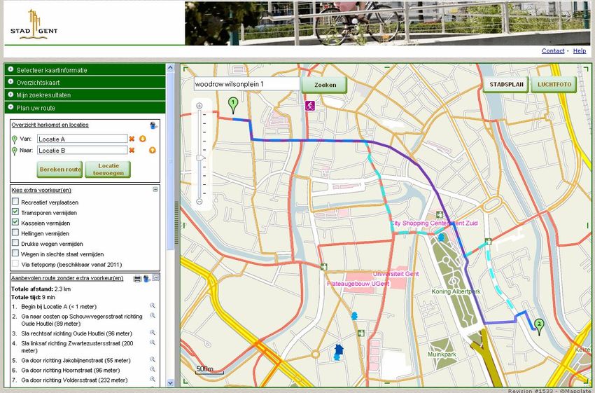
CONTENT

1. Summary ............................................................................................ 4
2. Timetable............................................................................................ 4
3. Route planner for bicycles ............................................................... 5
 3.1.     OBJECTIVES AND INNOVATIVE ASPECTS .................................................... 5
 3.2.     SITUATION BEFORE.................................................................................. 5
 3.3.     IMPLEMENTATION STATUS ........................................................................ 6
     3.3.1.   Research and development............................................................................... 6
              3.3.1.1.    Actors............................................................................................................6
              3.3.1.2.    Geographical area .........................................................................................7
              3.3.1.3.    Data input......................................................................................................7
              3.3.1.4.    Technical Conditions .....................................................................................8
              3.3.1.5.    Interface ......................................................................................................11
              3.3.1.6.    Searching....................................................................................................12
              3.3.1.7.    Routing .......................................................................................................14
              3.3.1.8.    Maintenance geodata and tool.....................................................................15
     3.3.2.   Test and implementation ................................................................................. 15
 3.4.     ROUTE PLANNER FOR BICYCLES IN THE NEAR FUTURE ............................. 15
4. Dissemination .................................................................................. 16
     4.1.1.   Participation and Communication.................................................................... 16
     4.1.2.   Participation and Communication in near future .............................................. 18
5. Data Collection for evaluation ....................................................... 18

                                                                                                                                           3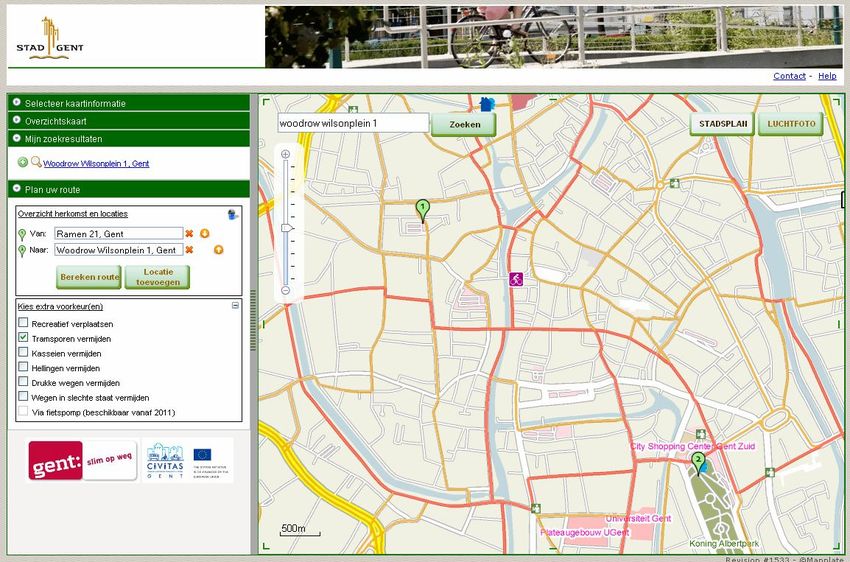
1. Summary
The route planner for bicycles is a tool for commuters, inhabitants and tourists to plan a trip along rec-
ommended and safe cycle routes in Gent. Next to providing safe and comfortable cycle routes, the tool
allows cyclists to plan their own personal routes. Cyclists can select their own preferences such as
cycling along green and relaxing axes, avoiding tram tracks, cobblestones, hills, heavy traffic and
roads in poor condition.
The aims of this tool are improving the safety for cyclists and increasing the number of bike trips.
As the City of Gent wants to improve the communication towards the large public by providing more
geographical information with a minimum effort, the development of this tool is part of the GentIS WEB
project of Digipolis and the City of Gent.
The route planner for bicycles www.gentfietst.be was launched at a press conference on 3 September
2010 and demonstrated at the CIVITAS square during the Car Free Day (19 September 2010).
In the near future (January 2011), the website www.gentfietst.be will be expanded with information of
all Gent cycle services. The route planner for bicycles will then be part of this website. (Expansion is
part of the measure 4.5-GEN ‘The House of the Bike’.) From January 2011 onwards the route planner
for bicycles will be accessible for foreigners (in 3 languages) and disabled and visually impaired citi-
zens. To keep the route planner for bicycles up to date, the visitors will have the possibility to give their
remarks or suggestions (tool integrated in route planner for bicycles). This will be communicated dur-
ing the large communication campaign of the website www.gentfietst.be in spring 2011. Demonstration
of the route planner for bicycles (e.g. loaning bike GPS systems) will also be done during sensitization
campaigns of other CIVITAS measures: mobility management for companies, schools, holistic event
management, mobility dialogue…

For evaluation the following data is being collected continuously: number of visits, unique visitors,
requested routes, remarks/suggestions and overview of requested routes. Also acceptance and
awareness surveys are planned.

2. Timetable
The timetable for the implementation of this measure is presented in Table 1 and indicates the main
deliverables and the accomplishment of Milestones and Working Documents related to the measure.
No. of M/       Name of M/ WD/ D                            Delivery      Achieved/      Actual/ Forecast
WD/ D                                                       date from     Delivered      achievement/
                                                            DoW           (Yes/No)       delivery date

                Decide on safest, shortest, most com-
8.10 – M1       fortable cycling routes and link attrib-     15.01.10           Y             31.01.10
                utes to the existing model

8.10 – M2       Test the internet based route planner        15.05.10           Y             12.07.10
8.10 – M3       Technical design completed                   15.07.10           Y             12.08.10
8.10 – WD1      System specification                         15.08.10           Y             15.08.10
8.10 – M4       Test the PDA                                 15.11.10           Y              15.11.10

                Implementation of the internet based
8.10 – M5                                                    15.09.10           Y             03.09.10
                route planner

                Implementation of the PDA bicycle
8.10 – M6                                                    15.01.11           Y              15.01.11
                route guidance system

8.10 – M7       Interviews to the target groups              15.03.11           Y              15.03.11

                                                                                                            4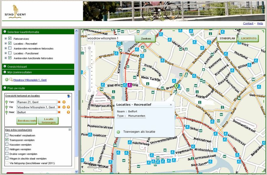
No. of M/ Name of M/ WD/ D Delivery Achieved/ Actual/ Forecast
WD/ D date from Delivered achievement/
DoW (Yes/No) delivery date
8.10 – M8 Gathering number of users and hits 15.03.11 Y 03.09.10
Evaluate interviews and number of
8.10 – WD2 15.09.11 N 15.09.11
users and hits
8.10 – M9 Website with specific information 15.09.10 Y 03.09.10
8.10 – M10 Promotion of the tool finished 15.08.11 N 15.08.11
Table 1: Timetable
3. Route planner for bicycles
3.1. Objectives and innovative aspects
The route planner for bicycles is a tool for commuters, inhabitants and tourists to plan a trip along rec-
ommended and safe cycle routes in Gent, even when it leads to small detours. The bike route planner
will show the safest cycling routes or alternative routes with cycling paths and little traffic. Additionally,
the system will show the availability of safe crossings by means of cycling tunnels or bridges.
At the same time, Digipolis starts with the GentIS WEB project. The aim of this project is setting up an
integrated and generated tool for publishing geographical information to the larger public. The devel-
opment of this route planner for bicycles is also part of the GentIS WEB project.
CIVITAS
The City of Gent wants to improve the safety for cyclist by increasing the awareness
of attractive and safe routes in Gent.
The City of Gent wants to stimulate the use of bicycles by commuters, inhabitants and
tourists.
The City of Gent wants to distribute information of the recommended bicycle routes,
which are now only available on paper maps, via the internet and new media.
GIS (Geographical Information System)
The City of Gent wants to improve the communication towards the large public by
providing more geographical information with a minimum effort. This will be reached
by setting up an integrated and generic technical solution.
3.2. Situation before
CIVITAS
Today cyclists often ride along roads in poor condition (cobblestones, tram tracks) and pressure traffic.
As a result there is a great feeling of insecurity among cyclists. To decrease this feeling of insecurity,
currently the city of Gent provides a route map for cyclists to help in planning routes throughout the
city. More and more cars are using navigation systems. Commuters are increasingly using a wide
range of planners via the internet. Tools like these allow planning quick, short and safe routes. For
cyclists, there are such systems available, but they rarely give information on safe routes.
GIS and WEBSITES GENT
5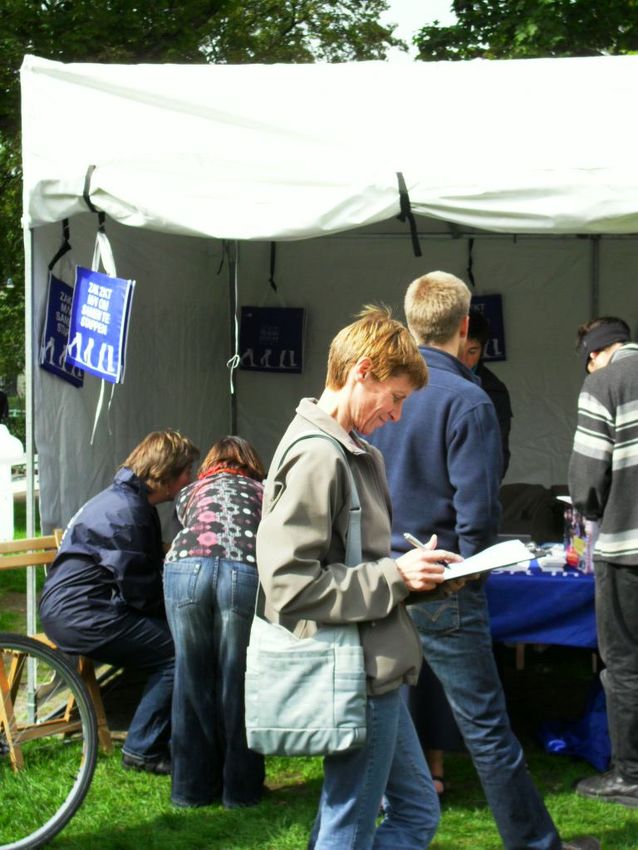
Currently more and more cars have route guidance systems. Via the Internet, car drivers and public
transport users can also simulate their trip with all kinds of models. They are able to look for the fastest
or shortest way. For cyclists, systems like this are available but they are not giving information about
the safest cycling route.
3.3. Implementation status
Within the City of Gent the idea to develop a Gent Route planner for bicycles has been present for a
long time, but no budget or personnel were found. Thanks to the CIVITAS project, the route planner
for bicycles is now a fact.
3.3.1. Research and development
3.3.1.1. Approach
After discussion with the actors involved in the project, we decided to develop an own system for the
on-line route planner rather than use, e.g., Google Maps.
The reasons are as follows:
- Basic routing data is the same as google maps but specific data for Gent is added (cycling net-
work Gent, one-way streets open for cyclists, prohibited roads for cyclists, condition of roads, tram
tracks, slopes, cobble stones, etc.)
- DIGIPOLIS wants to incorporate this knowledge in its organisation because more route planners
are to be developed in the future. Gaining the knowledge in-house and creating an own tool is
more cost-effective on the long term since no hosting and maintenance costs need to be paid.
- Better guarantee for exploitation after ELAN
3.3.1.2. Actors
Provincie
Province of Pendelaar
Commutor Inwoner
Inhabitant Recreatief
Recreational
OostEast
-Vlaanderen
Flanders Gent
of Gent cyclist
fietser
Road
Dienst
Department
wegen
Coordination
Coordination Coordination Beheerder
Mobility
Beheerder Beheerder mobiliteit
Geodata
geodata IT
toepassing
Mobility
Dienst
DAG Digipolis Department
mobiliteit
GIS -TEAM Dienst
Civil
bevolking
Department
Fig 1: Overview of actors in the project CityGent
Stad of Gent
Fig 1: Actors involved in the development of the Route planner for bicycles
In this project the following actors are involved:
Target groups: commuters, inhabitants, recreational cyclists
Mobility Department: project leader of Route planner for bicycles
6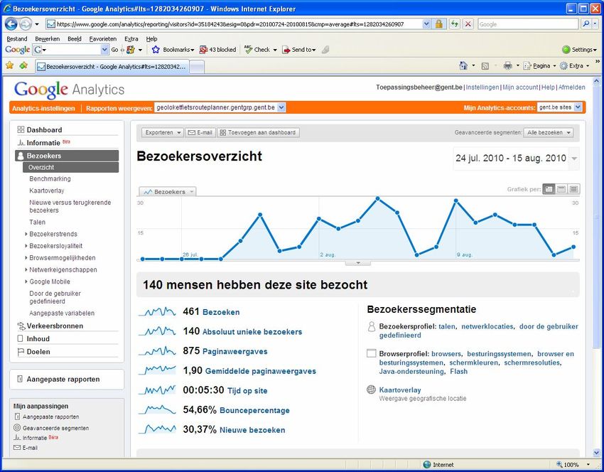
Data providers: City of Gent (road department, civil department, mobility depart-
ment,…) and the Province of East Flanders (information on the surroundings of Gent)
GIS team: DAG (coordination cel ‘Data, Analysis and GIS’ of City of Gent - coordina-
tion geodata) and Digipolis (coordination IT affairs).
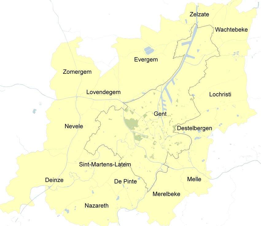
3.3.1.3. Geographical area
As the mobility department of the City of Gent wants to stimulate the commuters to travel by bike to
Gent, the bike route planner will provide cycle routes in Gent and suburbs. To get information of the
recommended and safe cycle network in the suburbs, a close cooperation with several departments of
the province of East Flanders has been established.
The municipalities of the suburbs are Zelzate, Wachtebeke, Lochristi, Destelbergen, Melle, Merelbeke,
De Pinte, Nazareth, Sint-Martens-Latem, Deinze, Nevele, Zomergem, Lovendegem and Evergem.
Fig 2: Geographical area which is covered by the route planner for bicycles
3.3.1.4. Data input
Reference map
As reference map, Tele Atlas network (2009) is used. As the Tele Atlas network is set up for car navi-
gation, the network needs to be extended with additional cycle paths, cycling tunnels and bridges. The
mobility department of the City of Gent is responsible for the input of these extra links. The source of
these extra links is the ‘Wegen Informatie Systeem’ (WIS) or road information system, set up and
maintained by the road department of the City of Gent.
Within the City of Gent, an aerial map can be shown as well.
7
Cycling network
There are two different networks: the functional cycling route network and the recreational cycling
route network.

The functional cycling route network connects the important attraction poles relating to ‘functional’ trips
(work, school, shopping…). The functional cycling route network, with their hierarchy, is worked out in
a well thought-out mobility plan of the City of Gent and in the ‘bovenlokaal functioneel
fietsroutenetwork’, the provincial functional cycling route network of the province of East Flanders.

The recreational cycling route network is the result of the ‘fietsknooppunten netwerk’ of Tourism East
Flanders added with extra recreational links within the City of Gent. The latest links are defined by the
mobility department and the tourism department of the City of Gent.

Points of Interest
The input of cycling services such as the location of cycle sheds, cycle shops and cycle service offices
will be maintained by the mobility department of the City of Gent.
The input of recreational points of interest such as museums, park, monuments, churches… is the
responsibility of the tourism department.
The functional points of interest such as hospitals, campus… is to be gathered and distributed by the
Data Analyse en GIS (DAG)-cel of the City of Gent.

Barriers
Barriers such as tram tracks and hills are put on the map by the mobility department of the City of
Gent (input from aerial maps).
Barriers such as cobblestones, roads in bad condition are gathered from the ‘Wegen Informatie Sys-
teem’ (WIS) or road information system, set up and maintained by the road department of the City of
Gent.
The barrier heavy traffic is derived from the traffic model of the City of Gent (status 2007).

3.3.1.5.        Technical Conditions
The route planner for bicycles is available for all users of different operating systems and browsers
(PC, Apple, Linux – Internet Explorer, Firefox, Safari, and Chrome). The development of the site is
based on the A-grade browser support chart of Yahoo (http://developer.yahoo.com/yui/articles/gbs).

The data are put in the Microsoft SQL server of Digipolis; the geodata are put in the ArcSDE environ-
ment of Digipolis.

                                                                                                            8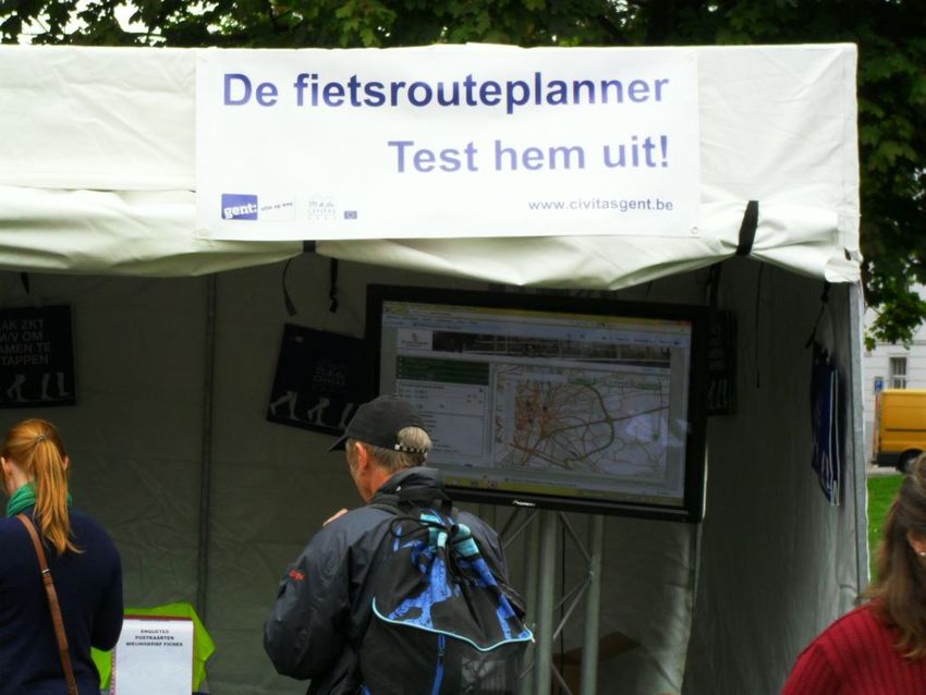
GIS-architecture
Beschikbaar Verplicht te
Legende voor gebruik gebruiken
Te bouwen
ArcGIS GentIS
Desktop intranet
Geoloket
Fietsrouteplanner
GentIS
DE
Laadmodule
GentIS GentIS
Dataservice GentIS Data
Stadsplan Geolocator Routing
service service
Fiets-
Thema data Adrespunten Referentie routenetwerk
Fiets- Gent
Gent straten routenetwerk
Straatassen OVL
Referentie Referentie
Gent adressen routenetwerk
Fig 3: GIS architecture of City of Gent
The route planner for bicycles tool is integrated into existing GIS architecture of the City of Gent. The
chart above shows the existing architecture.
All components are classified into three categories.
Parts available for use in building route planner tool: these GIS components are al-
ready used and can be part of the route planner tool, when necessary. (see fig 3 -
green)
Parts obliged to use in the route planner tool: these components are strategic ‘build-
ing blocs’ of the GIS architecture. As the route planner tool needs to be integrated in
the existing GIS architecture, these parts need to be used. (see fig 3 - orange)
Parts built during this project. (see fig 3 - blue)
9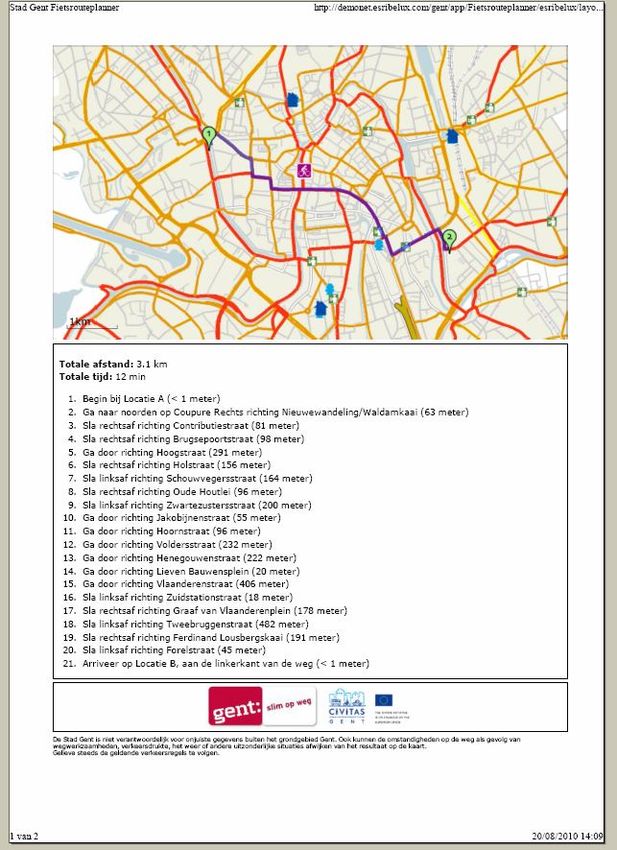
Analysis of the context model
Fig 4: Context model
The figure above contains the context model for this analysis. The circle contains all elements that
have an impact when setting up a route planner tool. The arrows leaving and going to the circle show
the interactions with the tool and are called processes.
All interactions from the context model are divided into five processes:
Interface of the route planner for bicycles
Searching
Routing
Maintenance geodata
Maintenance tool
103.3.1.6. Interface
The interface of the route planner for bicycles uses the ArcGIS Server image services.
Extra Search engine for addresses
information or locations Standard Aerial
map map
Overview map
Results of
search engine
Calculate
routes
Pick location
on map
Overview of
the (avoiding)
barriers
Fig 5: Interface of route planner for bicycles in City of Gent
The following information can be shown:
By selecting boxes in the window ‘Selecteer kaartinformatie (Select map information)’, the follow-
ing information will be viewed on the map:
Bicycle services: offices of bicycle services, bike pumps, (secured) bicycle sheds, bike
traders.
Recreational Point of Interest: churches, museums, monu-
ments, parks, markets, authentic places.
Recreational bike routes network.
Functional Point of Interest: schools, campuses, restaurants
for students, hospitals, railway stations.
Functional bike routes network.
By moving the cursor over the map.
Fig 6: Overview of the extra
information which can be shown
on the route planner for bicycles
11The route description(s) can be exported to print format.
Fig 7: Printable bicycle route description
3.3.1.7. Searching
The route planner for bicycles provides door-to-door routes, using either address points or points of
interest, with the option to personalise the routes by selecting criteria as cycling along green and at-
tractive roads or avoiding tram tracks, cobblestones, hills, heavy traffic or roads in bad condition. The
requested routes are given in a textual or a graphical form.
The users can select the start, end and via locations in 3 different ways:
12 Searching on address information.
Fig 8: Selecting locations by searching streetnames, adresses or locations through the search engines.
Selecting locations on the map.
Fig 9: Selecting locations by ‘picking’ locations on the map.
13 Selecting Point of Interest through information chart.
Fig 10: Selecting locations through the identification information on the map.
3.3.1.8. Routing
The route planner for bicycles automatically plans a trip along recommended and safe cycle routes in
Gent. To personalise the route planner for bicycles, the user can select one or more criteria as cycling
along green and attractive roads or avoiding tram tracks, cobblestones, hills, heavy traffic or roads in
bad condition.
Sometimes the personalised route leads to a large detour, for this reason both routes (with or without
personalised preferences) will be shown on the route planner. The user himself can decide which
route he or she wants to take.
Fig 11: 2 different routes after selecting personal criteria (here: avoiding tram tracks and cobblestones)
143.3.1.9. Maintenance geodata and tool
The data providers of the City of Gent (road department, civil department, mobility department…) and
the Province of East Flanders (responsible of the information on the surroundings of Gent) will update
their geodata on a yearly basis. This guarantees that the route planner for bicycles will be kept up-to-
date.
Digipolis is the owner of the bike route planner tool. When required, extension with extra functionalities
is possible.
3.3.2. Test and implementation
The stakeholders, namely the mobility department, the cyclist union, friends and families of col-
leagues, were invited to test this route planner tool after each (beta) release.
140 persons have tested the tool, especially the members of the cyclist union ands some colleagues
of the mobility department have given a lot of constructive feedback.
Although improvement is always necessary, generally all involved actors and stakeholders are
pleased with the route planner for bicycles.
Release
Server Date
version
Demo 0.1 12.07.10
Demo 0.2 5.08.10
Demo 0.3 11.08.10
Demo 0.4 18.08.10
Production 1.0 23.08.10
Table 2: Implementation time table
The route planner for bicycles went online on 23 August 2010 at www.gentfietst.be.
3.4. Route planner for bicycles in the near future
Following topics will be implemented in January 2011:
Expansion of the website www.gentfietst.be.
The City of Gent wants to increase the number of cyclists through various sensitiza-
tion activities and offer better information. Therefore, the information of all Gent cycle
services will be centralized and distributed through the website www.gentfietst.be.
The expansion is described in the measure 4.5-GEN ‘The House of the Bike’. The
route planner for bicycles will then be part of this website.
Accessibility of the route planner for foreign cyclists (foreign students or tourists):
it will be possible to consult the route planner in 3 languages: Dutch, French and Eng-
lish.
Accessibility of the bicycle route planner for the disabled, visually impaired and col-
our-blind citizens: to improve the accessibility of the route planner for bicycles the de-
veloper needs to reach an Anysurfer label by adjustments after an Anysurfer audit.
The Anysurfer is a Belgian quality label for accessibility of websites. Websites with the
label are accessible for everybody - also for visually impaired, blind, colour-blind, old
people and people who have an aural or physical handicap. In addition, accessible
15sites are generally better suited for small screens like that of a cell phone or PDA, and
can be used with any web browser. Finally, they score better in search engine results.
Stimulate use of bike GPS systems:
By exporting the planned routes to GPX format.
By loaning 4 bike GPS systems to several target groups. A closed coopera-
tion with the other measure leaders is required.
Citizens’ participation: a GIS-environment will be developed where visitors can insert
their feedback. This environment will be integrated in the route planner for bicycles.
(Research on this issue is still ongoing.)
4. Dissemination
4.1.1. Participation and Communication
The following activities were conducted/are planned during the period of September 2010 – January
2011:
Stakeholder participation during the test phase of the route planner for bicycles (mo-
bility department, cyclist union, friends or families of colleagues). They gave remarks
and suggestions to improve the quality of the route planner for bicycles.
Launch of route planner for bicycles at a press conference by the alderman for mobil-
ity, Karin Temmerman, 3 September 2010. The launch was successful, the rout plan-
ner for bicycles is shown on local television AVS, newspapers, …
Demonstration of Route planner for bicycles at the CIVITAS square on the Car Free
Day, 19 September 2010.
Design of flyer finished (10,000 flyers ordered) on 16 August 2010.
Distribution of flyers in Baudelopark (CIVITAS square) and Sint-Pietersplein (start bi-
cycle tour on ring road) during the Car Free Day, 19 September 2010.
Distribution of flyers at the university and at high schools planned in October 2010.
The result of the Integrated Package ‘Stimulating Cycling and Walking’-survey to-
wards students (Nov 2009), indicates that the students are an important target group
for the Route planner campaign: 83.6% of the 65,000 students do have a bike in Gent
and ± 67% agreed that the development of a route planner for bicycles is a positive
initiative of the City of Gent.
Mailings
Fig 12: Flyer Route planner for bicycles (postcard format)
16th
Fig 13: Demonstration Route planner for bicycles at CIVITAS place during Car Free Day (19 of September)
174.1.2. Participation and Communication in near future
The following activities are planned from March 2011 onwards:
During the second test phase, stakeholders (mobility departments, cyclists union,
friends or families of colleagues) will be invited again to give remarks or suggestions
to improve the quality of the route planner for bicycles.
Stimulate citizens’ engagement by setting up an integrated tool where anyone can
give any remarks or suggestions on the route planner for bicycles.
The promotion campaign for the route planner for bicycles will be an integrated part of
the communication campaign of the website ‘House of the Bike’: www.gentfietst.be
The Tourist Office of the City of Gent wants to promote Gent as a Bike Town, for this
reason it is agreed that they will promote our route planner for bicycles through their
communication channels as well.
Distributing flyers, demonstrating route planner for bicycles or loaning bike GPS sys-
tems during sensitization campaigns of other CIVITAS measures: mobility manage-
ment for companies, schools, holistic event management, mobility dialogue…
Presentation on regional television (AVS).
Mailings.
…
When the route planner for bicycles will be available in English, the tool will be presented within CIVI-
TAS-ELAN, especially to Measure Leaders of the measures involved with improving cycling conditions
and facilitating cycling in other ELAN cities. It is also considered to present the tool to a larger audi-
ence, e.g. at a CIVITAS Forum or other sustainable urban transport related conferences.
5. Data Collection for evaluation
On Integrated Package ‘Stimulating Cycling and Walking’ level, it is planned to conduct some surveys
towards several target groups, namely students, inhabitants of Gent living in the surroundings of the
main train station area and cyclists/pedestrians.
The before surveys were done in November 2009 and March 2010.
1. Students: through mailings – sample size: all students.
2. Inhabitants of Gent living in the surroundings of the main train station
area: mail survey – sample size: 360 (95% confidence interval).
3. Cyclists/pedestrians: on-street survey – sample size: 400.
The after surveys are planned in 2011 and/or 2012.
With use of Google Analytics following figures will be collected continuously:
Number of visitors.
Number of unique visitors.
Number of requested routes.
Number and kind of remarks/suggestions.
User acceptance of the Route planner for bicycles.
18Fig 14: Data collection with use of Google Analytics
19You can also read


