International GNSS Service (IGS) - TUM
←
→
Page content transcription
If your browser does not render page correctly, please read the page content below
International GNSS Service (IGS) 1
International GNSS Service (IGS)
http://www.igs.org/
Chair of the GB: Gary Johnston (Australia)
Director of the Central Bureau: Allison Craddock (USA)
July 2015 - June 2019
Overview
For twenty-five years, the International GNSS Service (IGS, where GNSS stands for Global
Navigation Satellite Systems) has carried out its mission to advocate for and provide freely and
openly available high-precision GNSS data and products. The IGS was first approved by its
parent organization, the International Association of Geodesy (IAG), at a scientific meeting in
Beijing, China, in August of 1993. A quarter century later, the IGS community gathered for a
workshop in Wuhan, China to blaze a path to Multi-GNSS through global collaboration. An
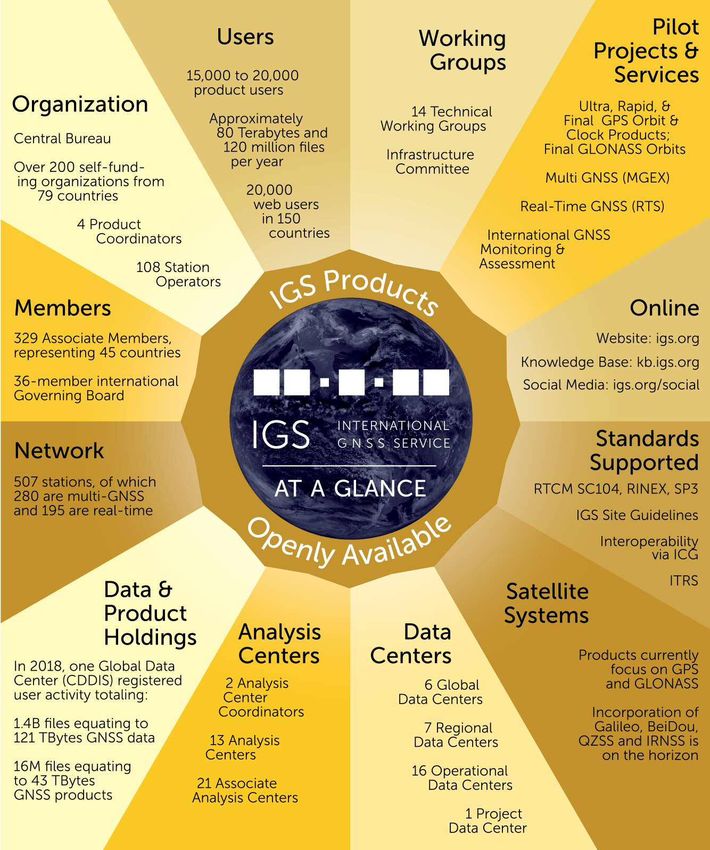
overview of the current state of the organization is depicted on Fig. 1.
The IGS is a central component of the IAG’s Global Geodetic Observing System (GGOS), where
it facilitates cost-effective geometrical linkages with and among other precise geodetic observing
techniques, including: Satellite Laser Ranging (SLR), Very Long Baseline Interferometry
(VLBI), and Doppler Orbitography and Radio Positioning Integrated by Satellite (DORIS). These
linkages are fundamental to generating and accessing the ITRF. As it enters its second quarter-
century, the IGS is evolving into a truly multi-GNSS service, and at its heart is a strong culture
of sharing expertise, infrastructure, and other resources for the purpose of encouraging global best
practices for developing and delivering GNSS data and products all over the world.
In 2015, the IGS Governing Board (GB) started the process of reviewing its Strategic Plan. Issues
under consideration include the scope of products and services, appropriate acknowledgement of
participants and contributors, interface with IAG and GGOS, data and product licensing,
continued Global Positioning System (GPS) to GNSS transition, and new activities around GNSS
system monitoring and assessment. A follow-on 2017 Strategic Plan was published in early 2018;
and preliminary discussions regarding a 2020 strategic plan have commenced. This plan
recognizes the extensive contribution of the IGS participants, and encourages further engagement
with a broader stakeholder set, that now relies implicitly on IGS products and services.
From 2015-2019, the IGS continued to evolve its work program to meet user and community
needs. While delivery of the IGS core reference frame, orbit, clock and atmospheric products
continues to drive the core activities, the IGS transformation to a multi-GNSS service continued
with the harmonization of the Multi GNSS Experiment (MGEX) network sites into the existing
IGS network. The IGS has also engaged with the International Committee on Global Navigation
Systems (ICG) in the ICG-IGS Joint Trial Project (IGMA), which aims to provide monitoring
and assessment products for all GNSS constellations.
In 2018, there was a change within the IGS Central Bureau (CB), with the long-standing
Director of the CB, Ruth Neilan, moving on to other ventures after serving the IGS community
since before its inception. The contribution Neilan has made to science and society through the
IGS cannot be underestimated, and the IGS wishes her well in her future endeavors. We also
recognize the contributions of Steve Fisher, who departed the CB in 2017, after many years of
service.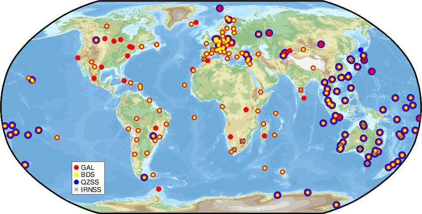
Report of the IAG Vol. 41   Travaux de l’AIG 2015-2019              2

                             Figure 1: IGS “at glance”, as of May 2019

The IGS continues to function as a service of the IAG, and a contributor to GGOS. Accordingly,
a number of the GB members continue to participate in IAG and GGOS governance, bureaus,
commissions and WG, ensuring the IGS retains its strong level of relevance, and therefore
sustainability. Importantly, GB members also participate in the United Nations Global
Geospatial Information Management (UN-GGIM) Subcommittee on Geodesy, which aims to
enhance the sustainability of the GGRF through intergovernmental advocacy for geodesy. GB
members also routinely invited to present and provide valuable input at the National Space-
Based Positioning, Navigation, and Timing (PNT) Advisory Board, exerting an influence at
high levels in the United States government.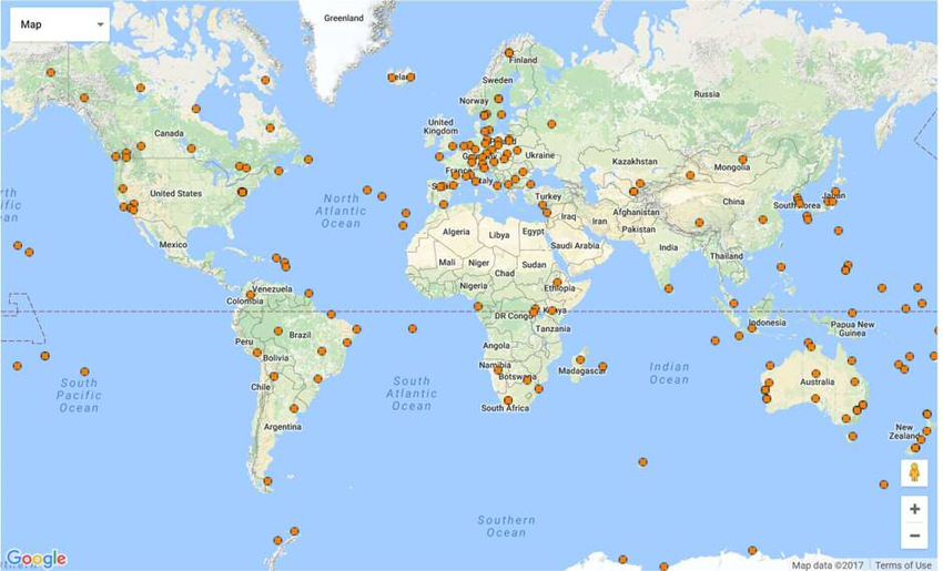
International GNSS Service (IGS)                                3

IGS Structure, Membership Growth, and Internal Engagement

In 2019, IGS membership reached 329 Associate Members (AM), representing 45 countries.
The 36-member IGS GB guides the coordination of over 200 contributing organizations
participating within IGS, including 108 operators of GNSS network tracking stations, 6 global
Data Centers (DCs), 13 Analysis Centers (ACs), and 4 product coordinators, 21 associate ACs,
23 regional/project DCs, 14 technical Working Groups (WG), two active pilot projects (i.e.,
Multi-GNSS and Real-time), and the CB. The IGS structure is depicted on Fig.2.

In order to best understand who among the listed members are still active, the CB and Elections
Committee Members conducted an online campaign asking all AM to verify their continued
interest in participating in the IGS, and to update their contact information. Further engagement
with AMs included removing the 10 person per organization cap in favor of a case-by-case
review of AM applications.

A comprehensive overhaul of AM engagement documents, including GB elections and other
mentions in the IGS Terms of Reference, will take place in 2019.

Governing Board

The IGS is led by an international GB (Table 1) that is comprised of seats elected by AMs who
represent the principal IGS participants, as well as chairs of IGS WGs, members appointed by
the Board to fill competence or geographical representation gaps, and representatives of
stakeholder organizations. The GB discusses the activities of the various IGS components, sets
policies and monitors the progress with respect to the agreed strategic plan and GB directives.

IGS Central Bureau

Executive management of the IGS (Table 2) is carried out by the CB, whose office is hosted at
the National Aeronautics and Space Administration (NASA) Jet Propulsion Laboratory (JPL),
California Institute of Technology, in Pasadena, California, USA. It is funded principally by NASA,
which generously contributes significant staff, resources, and coordination to advance the IGS.

The mission of the IGS CB is to provide continuous management and technological resources in
order to sustain the multifaceted efforts of the IGS in perpetuity. It functions as the executive office
of the Service and responds to the directives and decisions of the IGS GB. The CB coordinates the
IGS tracking network and operates the CB Information System (CBIS), the principal information
portal where the IGS web, ftp (https) and mail services are hosted. The CB also represents the
outward face of IGS to a diverse global user community, as well as the general public.

Staff of the CB, as part of its work program carrying out the business needs of the IGS,
implements actions defined by the GB. This include a thorough analysis and refresh of the IGS
Terms of Reference, supporting the ongoing update of the AMs list, prepare and support the
GB elections, and plays an active role in supporting the organization of regular IGS Workshops
and GB meetings. Additionally, CB works closely with members of the GB Executive
Committee (EC) in developing and addressing feedback pertaining the Strategic Plan.

The CB continued to develop communications, advocacy, and public information initiatives on behalf
of the GB. CB members also led a communications interest and development session at all IGS
Workshops. The CB actively works with other IAG components to promote communications and
outreach, including the IAG Communications and Outreach Branch and GGOS Coordinating Office.
Report of the IAG Vol. 41   Travaux de l’AIG 2015-2019   4

       Figure 2: IGS Structure as of 2019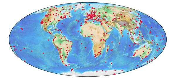
International GNSS Service (IGS)                                   5

Table 1: Governing Board (as of May 2019)

 Status                  Affiliation                            Country       Role
          G. Petit       Bureau International des Poids et      France        BIPM/CCTF
                         Mesures                                              Representative
                                                                              (Appointed)
  EC-V    G. Johnston    Geoscience Australia                   Australia     Board Chair
          M. Moore       Geoscience Australia                   Australia     AC Co-Coordinators
  EC-V    C. Rizos       University of New South Wales          Australia     IAG Representative
          S. Banville    Natural Resources Canada /             Canada        PPP-AR WG Chair
                         Ressources naturelles Canada
          VACANT         VACANT                                 VACANT        RINEX/RTCM Group
                                                                              Chair
     V    Q. Zhao        Wuhan University                       China         Appointed (IGS)
          F. Perosanz    Centre National d'Etudes               France        Vice Board Chair
                         Spatiales
     V    Z. Altamimi    Institut National de l'Information     France        IAG Representative
                         Géographique et Forestière
     V    P.             Institut National de l'Information     France        IGS Reference Frame
          Rebischung     Géographique et Forestière                           Coordinator
     V    L. Sánchez     DGFI-TUM                               Germany       Network
                                                                              Representative
          O.             Deutsches Zentrum für Luft- und        Germany       Multi-GNSS WG Chair
          Montenbruck    Raumfahrt
          T. Schöne      Deutsches                              Germany       TIGA WG Chair
                         GeoForschungsZentrum Potsdam
          T. Springer    ESA/European Space Operations          Germany       IGMA-IGS Joint GNSS
                         Center                                               Monitoring and
                                                                              Assessment Trial
                                                                              Project Chair
     V    L. Agrotis     ESA/European Space Operations          Germany       Real-time Analysis
                         Centre                                               Coordinator
     V    W. Enderle     ESA/European Space Operations          Germany       Appointed (IGS)
                         Centre
          I. Romero      ESA/European Space Operations          Germany       Infrastructure
                         Centre                                               Committee Chair
          A. Hauschild   Deutsches Zentrum für Luft- und        Germany       Real-time WG, Chair
                         Raumfahrt
          W. Söhne       Federal Agency for Cartography         Germany       Network
                         and Geodesy (BKG)                                    Representative
     V    S. Kogure      National Space Policy Secretariat      Japan         Appointed (IGS)
                         (NSPS), Cabinet Office
          A.             University of Warmia and Mazury        Poland        Ionosphere WG Chair
          Krankowski     in Olsztyn
  EC-V,   R. Dach        Astronomical Institute, University     Switzerland   AC Representative
     IR                  of Bern
          A. Villiger    Astronomical Institute, University     Switzerland   Antenna WG Chair
                         of Bern
          S. Schaer      Federal Office of Topography -         Switzerland   Calibration & Bias WG
                         swisstopo                                            Chair
          M. Ziebart     University College London              UK            Satellite Vehicle Orbit
                                                                              Dynamics WG Chair
     V    S. Desai       NASA Jet Propulsion Laboratory         USA           AC Representative
     V    R. Gross       NASA Jet Propulsion Laboratory         USA           Representative to the
                                                                              IERS
Report of the IAG Vol. 41 Travaux de l’AIG 2015-2019 6
V T. Herring Massachusetts Institute of USA AC Coordinator
Technology (MIT)
C. Noll NASA Goddard Space Flight USA DC WG Chair
Center
EC-V A. Craddock NASA Jet Propulsion Laboratory USA Director of IGS CB
V D. Stowers NASA Jet Propulsion Laboratory USA DC Representative
VACANT VACANT VACANT AC Representative
V M. Coleman U.S Naval Research Laboratory USA IGS Clock Products
Coordinator
D. Maggert UNAVCO USA Network Coordinator
EC-V, C. Meertens UNAVCO USA Appointed (IGS)
IR
S. Byram United States Naval Observatory USA Troposphere WG,
Chair
EC-V = Executive Committee Voting Member • V = Voting Member • • RI = Representative to the IERS
Table 2: IGS Central Bureau Staff (2019)
Name Affiliation Role
Allison Craddock NASA Jet Propulsion Laboratory Director
Mayra I. Oyola NASA Jet Propulsion Laboratory (Acting) Deputy Director and
GB Executive Secretary
David Maggert UNAVCO Network Coordinator
Robert Khachikyan Raytheon Corporation CBIS Engineer
David Stowers NASA Jet Propulsion Laboratory CBIS Advisor
Michael Connally NASA Jet Propulsion Laboratory Accounts Manager
United Nations GGIM Subcommittee on Geodesy
Members of the IGS GB actively participated in the fifth session of the UN–GGIM at UN
Headquarters in New York. IGS GB members involved in the UN-GGIM Global Geodetic
Reference Frame (GGRF) WG played an active role in drafting a resolution for “A Global
Geodetic Reference Frame for Sustainable Development” – the first resolution recognizing the
importance of a globally–coordinated approach to geodesy. This resolution was adopted in
February 2015 by the UN General Assembly. IGS remains active in engaging with diverse
organizations that have an interest in geodetic applications of GNSS. IGS Associate and GB
members continue to participate in contributing to five WGs developed to draft the
implementation plan for the GGIM GGRF Roadmap. Details and updates may be viewed on
the UN-GGIM website: http://ggim.un.org.
United Nations International Committee on GNSS
IGS GB members also served in leadership roles in the United Nations International Committee
on GNSS (ICG), including the WG D on Reference Frames, Timing, and Applications, and
other components.
IGS Working Groups
The IGS technical WGs work on topics of particular interest to the IGS, such as improving the
IGS products and infrastructure. Within the WGs, a Pilot Project structure has been defined
whereby new capabilities or products are envisioned, developed, tested, and prepared for
production. Policy for the Establishment of IGS WGs, Pilot Projects, and New Operational
Products. The currently active WGs, and their corresponding Chairs are included on Table 3.International GNSS Service (IGS) 7
Table 3: IGS Working Groups
Working Group Chair WG Established
Antenna Arturo Villiger (2016-Present) 2008
Ralf Schmid (2008-2016)
Bias and Stefan Schaer 2008
Calibration
Clock Products Michael Coleman 2003
Data Center Carey Noll 2002
GNSS Tim Springer (2018-Present) 2017
Monitoring Urs Hugentobler (2017-2018)
(IGMA)
Ionosphere Andrzej Krankowski 1998
Multi-GNSS Oliver Montenbruck 2003
Precise Point Simon Banville 2018
Positioning
with Ambiguity
Resolution
Real Time André Hauschild (2018-Present) 2001
Axel Rülke (2016-2018)
Reference Paul Rebischung (2017-Present) 1999
Frames Bruno Garayt (2010-2017)
RINEX VACANT 2011
Ken MacLeod (2011-2019)
Space Vehicles Tim Springer (2018-Present) 2011
Orbit Dynamics Marek Ziebart (2011-2018)
Tide Gauge Tilo Schöne 2001
(TIGA)
Troposphere Sharyl Byram (2015-Present) 1998
Christine Hackman (2011-2015)
IGS Operational Activities
Daily operations are the heart of the IGS. Various components of the service ensure that
tracking data and products are made publicly available every day. Over 500 IGS Network
tracking stations (Fig. 3) are maintained and operated globally by many institutions and station
operators, making tracking data available at latencies ranging from daily Receiver INdependent
EXchange (RINEX) files to real-time streams available for free public use.
The transition of the IGS network to multi-GNSS capability was highlighted in the 2018
Workshop, with all WG chairs introducing multi-GNSS topics in their splinter sessions.
Significant effort on behalf of the MGEX Pilot Project and WG has also continued, with
approximately 55% of IGS network stations being capable of tracking multiple GNSS
constellations (GPS + Globalnaya Navigazionnaya Sputnikovaya Sistema (GLONASS) + at
least one other) as of December, 2018 (Fig. 4).
The amount of IGS tracking data and products hosted by each of the four global DCs on
permanently accessible servers increased significantly over the last four years, supported by
significant additional storage capabilities provided by Regional DCs.Report of the IAG Vol. 41 Travaux de l’AIG 2015-2019 8
Figure 3: Global Distribution of IGS Stations as of May 17, 2019.
Twelve ACs and a number of Associate ACs utilize tracking data from between 70 to more
than 350 stations to generate precision products up to four times per day. Product coordinators
combine these products on a continuous basis and assure the quality of the products made
available to the users.
The collective effort of the IGS produces 700 IGS final, rapid, ultra–rapid and GLONASS-only
product files, as well as 126 ionosphere files weekly. A total of 1.4 billion tracking data files
(121 TB) and 16 million product files (43 TB) were downloaded in 2018 from the NASA
CDDIS, one of four IGS global DCs, by more than 10,000 unique hosts – demonstrating the
intense interest of users in IGS data and products. Troposphere files for more than 300 stations
are produced on a daily basis. For Tropospheric downloads, CDDIS reports over 46M files
totaling over 125 GB in 2016 from 500K unique hosts each month.
Delivery of core reference frame, orbit, clock and atmospheric products continues strongly. The
IGS has also seen further refinement of the Real-Time Service with considerable efforts being
targeted towards development of Standards. The transition to multi GNSS also continues apace
within the IGS, with additional Galileo and BeiDou satellite launches bringing those
constellations closer to operational status. By the beginning of 2019, the deployment of the
Galileo constellation was completed with 24 active satellites.
With the assistance of the CB Network Coordinator, the IGS network added 14 stations and
decommissioned 12 stations in 2018, bringing the total to 507 stations. In early 2018, the CB
Network Coordinator updated the Site Log Manager database and website to accommodate the
9-character station codes. All internal CB operational scripts were also updated to accommodate
the 9-character station codes. Later in 2018, the CB real-time caster was updated to use the 9-
character station code as recommended by the Real Time WG. Throughout the year, the CB
Network Coordinator worked with station operators on various topics including recommended
firmware upgrades, antenna alignment, receiver constellation tracking, and missing station photos.
The CB Network Coordinator supported the IGS user community by reviewing and accepting
487 IGS site log updates, and worked in collaboration with the Antenna WG Chair and
equipment manufacturers to provide 54 changes to the rcvr_ant.tab and antenna.gra equipment files.International GNSS Service (IGS) 9
Figure 4: IGS Multi-GNSS Tracking Network map (P. Steigenberger)
With the assistance of the CB Network Coordinator, the IGS network added 14 stations and
decommissioned 12 stations in 2018, bringing the total to 507 stations. In early 2018, the CB
Network Coordinator updated the Site Log Manager database and website to accommodate the
9-character station codes. All internal CB operational scripts were also updated to accommodate
the 9-character station codes. Later in 2018, the CB real-time caster was updated to use the 9-
character station code as recommended by the Real Time WG. Throughout the year, the CB
Network Coordinator worked with station operators on various topics including recommended
firmware upgrades, antenna alignment, receiver constellation tracking, and missing station photos.
The CB Network Coordinator supported the IGS user community by reviewing and accepting
487 IGS site log updates, and worked in collaboration with the Antenna WG Chair and
equipment manufacturers to provide 54 changes to the rcvr_ant.tab and antenna.gra equipment files.
IGS Highlights (2015-2019)
The following is a brief summary of key highlights between 2015-2019 (Fig. 1):
Membership growth and engagement
Increased outreach and engagement with the IGS AM has taken place, particularly after the
second open AM meeting in December 2017. IGS has also foster increased interactions with
AMs via IGS social media platforms.
Analysis Center Coordinator
At the end of 2015, the Analyses Center Coordinator (ACC) role was transferred from Kevin
Choi (US National Geodetic Survey (NGS)) to a joint management by Geoscience Australia
(GA) and Massachusetts Institute of Technology (MIT). The proposal for this joint ventured,
identified Dr. Thomas Herring (MIT) as the lead ACC, with operational support from Dr.
Michael Moore (GA). This proposal utilizes Amazon Web Services (AWS) for the computing
platform, and a collaborative operational model where the monitoring of combination systems
is undertaken by MIT during their working day, and GA at other times. This reduced the need
for 24hour /day monitoring by one individual. This proposal was subsequently accepted and
endorsed by the GB. Joint management of the IGS ACC continues to this date, with operations
based at GA in Canberra, Australia. The ACC combination software is housed on cloud-basedReport of the IAG Vol. 41 Travaux de l’AIG 2015-2019 10 servers (located in Australia and Europe), and coordination of the IGS product generation continues to be carried out by personnel distributed between GA and MIT. The IGS continues to maintain a very high level of product availability. MGEX experiment and ICG Monitoring and Assessment Joint Pilot Project The success of the MGEX (Multi-GNSS Experiment) demonstrated the inevitability of a transition of the IGS to a full multi–GNSS Service. Accordingly, the GB decided to acknowledge this by terminating the “experiment” status and move MGEX to the status of a Pilot Project. In 2015 discussions occurred between the IGS GB and representatives from the ICG concerning the establishment of joint pilot to undertake monitoring and assessment of the GNSS constellations. The IGMA Project has experienced growth, and idea of using the existing monitoring infrastructure of IGS MGEX was introduced in 2017. The Trial Project established a Terms of Reference document, and has distributed Calls for Participation both geared toward ICG providers as well as the IGS community. The IGMA WG was formed as a complement to the ICG-IGS Joint Trial Project. Continued efforts are required to negotiate access to satellite specific information for new satellites from system providers, allowing for more realistic models of satellite behavior to be developed and utilized by the IGS ACs. New Global Data Centers in China and Spain Wuhan University was added as an IGS Global DC in 2017, and the GB officially endorsed fully-weighted adoption of Wuhan Rapid products. The Wuhan DC offers access to the full collection of IGS data and products to any user globally, especially those within the Asia Pacific Region. Importantly the DC gives direct access to the IGS data holdings to the very large research sector within China. The European Space Agency’s European Space Astronomy Centre (ESA/ESAC) also became an IGS Global DC in 2017, and is based in Madrid, Spain. Reprocessing campaign: repro2 Following the first reprocessing campaign performed by the IGS in 2008, a second reprocessing campaign (repro2) was finalized in 2015. Nine different ACs reanalyzed the history of GNSS data collected by a global tracking network back to 1994 using the latest available models and methodology. Besides supplying an improved consistent set of GNSS geodetic products, one major goal of the repro2 campaign was to provide the IGS input to the latest release of the International Terrestrial Reference Frame (ITRF2014). The individual AC products were combined into official IGS repro2 products called "ig2". Results from the repro2 terrestrial frame combinations are described in Rebischung et al. (2016; https://doi.org/10.1007/s00190- 016-0897-6), while results from the repro2 orbit and clock combinations are summarized in IGSMAIL-7411 (https://igscb.jpl.nasa.gov/pipermail/igsmail/2017/008601.html). Troposphere repro2 results are currently being processed and evaluated. Adoption of IGS14 Reference Frame The IGS adopted a new reference frame, called IGS14, on 29 January 2017 (GPS Week 1934). At the same time, an updated set of satellite and ground antenna calibrations, igs14.atx, was implemented. IGS14 is the latest in a series of GNSS reference frames adopted by the IGS. These reference frames form the basis of the IGS products, and are derived from each new version of the ITRF. Updating to IGS14 aligned IGS products to ITRF2014, and increased precision of that alignment by integrating additional available reference frame stations with more precise and up-to-date coordinates.
International GNSS Service (IGS)                             11

Antenna calibration updates
Coincident with the IGS14 Reference Frame release, IGS adopted antenna calibration updates in
igs14.atx. These updates included robot calibrations for additional ground antenna types, increasing
the percentage of ground stations in the IGS network with absolute calibrations to over 90%.
This resulted in increased coordinate accuracy for stations equipped with these antennas. Data
for the second reprocessing campaign can be found at: http://acc.igs.org/reprocess2.html

Standards development support
The IGS continues to contribute to the development of international standards related to GNSS,
principally through participation within the RTCM (Radio Technical Commission for Maritime
Service), where IGS leads the RINEX WG, as well as participating within the standards activities
related to real time systems. RINEX is an internationally recognized GNSS observation and
navigation data format. The first version of RINEX was developed in 1989, to support a
European GPS data collection campaign. The key objective was to develop an open and human
readable (ASCII) GNSS data format that removed the need of specialized decoders/interpreters
for each GNSS receiver type. Under the leadership of Werner Gurtner (Astronomical Institute,
University of Bern, Switzerland) and Lou Estey (UNAVCO, Boulder, Colorado, USA), RINEX
evolved from version 1 to 2 and then to 3. Since 2013 (RINEX Version 3.02) the RINEX GNSS
format has been maintained by the RINEX WG, which consists of members from the IGS, the
RTCM Special Committee 104 (RTCM-SC104) and the GNSS industry.

Adoption of RINEX V3.04 and 9-character identification format
The GB agreed to adopt the official RINEX V3.04 format. It contains a new convention for file
naming including the ability for 9-character ID and fixing the definition of GNSS reference
time scales. The RINEX WG has assumed leadership in maintenance and further development
of the RINEX data exchange standard, in cooperation with RTCM-SC104, and has led the
recent release of RINEX 3.03. The RINEX WG has worked in cooperation with the
Infrastructure Committee (IC) to prepare a plan to transition from RINEX 2.x to RINEX 3.x.
The IGS network map was enhanced to provide information about stations providing data in
RINEX 2 and RINEX 3 formats, which may be viewed in real time at:
http://www.igs.org/network. The current RINEX 3.04 release supports all publicly available
signals, including the United States’ GPS, Russia’s GLONASS, Europe’s Galileo, China’s
BeiDou, Japan’s Quasi Zenith Satellite System (QZSS) and the Indian Regional Navigation
Satellite System (IRNSS) constellations. RINEX 3.04 contains updates to support planned
GLONASS CDMA signals, as well as new BeiDou III and QZSS II signals.

In addition to the new signals, the RINEX 3.04 text has been edited to improve the description
of messages, fields and overall readability. The RINEX 3.04 data standard documentation is
available from the following addresses: ftp://igs.org/pub/data/format/rinex304.pdf,
ftp://igs.org/pub/data/format/rinex304-release-notes.pdf and http://www.rtcm.org/differential-
global-navigation-satellite—dgnss—standards.html.

The IC and DC Coordinator are working on integrating long filenames, RINEX3 data into
operational archives. The Troposphere WG is also incorporating long names in its SINEX
output files.

IGS web-based assets (IGS.org)
The IGS CB has moved IT services to external cloud hosted servers, in order to allow global
access. IGS product access was redirected from IGS CB mirrors to the Crustal Dynamics Data
Information System (CDDIS, ftp://cddis.gsfc.nasa.gov/gnss/products/), Institut National de
Report of the IAG Vol. 41   Travaux de l’AIG 2015-2019                        12

l’Information Géographique et Forestière (IGN, ftp://igs.ensg.ign. fr/pub/igs/products/) and the
Scripps Institution of Oceanography (SIO, ftp://garner. ucsd.edu/pub/products/) to ensure
global access to over 20 years of analysis products, as well as enabling access to data. The IGS
also moved its Real-Time Service (RTS) caster to a supercomputing center to ensure
performance, availability, and service monitoring.

Content and resources in the IGS Knowledge Base, http://kb.igs.org, continue to be enhanced
and expanded. Workshop resources, including images, posters, presentation slides, and videos,
also continue to be made available on the website. The next generation of the website is
currently under development by the IGS CB and will be released during Fall 2019.

IGS GB Meetings

Table 4 summarizes the numerous meetings that have taken place over the period between
2015-2019.
Table 4: IGS Governing board Meetings 2015-2019

                            Date Place                                     Comments
                  12 April, 2015 Vienna, Austria                           Prior European Geophysical
                                                                           Union Meeting
                  23 June, 2015 Prague, Czech Republic                     During 26th IUGG/IAG General
                                                                           Assembly
            13 December, 2015 California, USA                              Prior American Geophysical
                                                                           Union Meeting
               7 February, 2016 Sydney, Australia                          Session 1 out 2: Prior IGS
                                                                           Workshop
              12 February, 2016 Sydney, Australia                          Session 2 out 2: After IGS
                                                                           Workshop
                  17 April, 2016 Vienna, Austria                           Prior European Geophysical
                                                                           Union Meeting
            11 December, 2016 California, USA                              Prior American Geophysical
                                                                           Union Meeting
                  23 April, 2017 Vienna, Austria                           Prior European Geophysical
                                                                           Union Meeting
                   02 July, 2017 Paris, France                             Session 1 out 2: Prior IGS
                                                                           Workshop
                   07 July, 2017 Paris, France                             Session 2 out 2: After IGS
                                                                           Workshop
            11 December, 2017 Louisiana, USA                               Prior American Geophysical
                                                                           Union Meeting
                  08 April, 2018 Vienna, Austria                           Prior European Geophysical
                                                                           Union Meeting
               28 October, 2018 Wuhan, China                               Session 1 out 2: Prior IGS
                                                                           Workshop
            02 November, 2019 Wuhan, China                                 Session 2 out 2: After IGS
                                                                           Workshop
            09 December, 2018 Washington, DC, USA                          Prior American Geophysical
                                                                           Union Meeting
                  07 April, 2019 Vienna, Austria                           Prior American Geophysical
                                                                           Union Meeting
       15 July, 2019 (upcoming) Montreal, Canada                           During IUGG Meeting
International GNSS Service (IGS) 13
IGS Workshops
In 2016, it was decided to move the workshops to an 18-month cycle, due to the wealth of topics
and quickening pace of technological development impacting the IGS.
IGS Workshop on GNSS Biases 2015
This workshop was held at the University of Bern on 5–6 November 2015. All related
information, including all presentations, may be found at: http://www.biasws2015.unibe.ch.
The main focus of this workshop was on:
Characteristics and handling of GNSS biases: Most of the presentations ad-dressed
related topics and provided corresponding updates.
Bias-SINEX Format Version 1.00: A first draft format document was prepared and
presented at the workshop. Essential format aspects and issues were discussed in the
plenum. An accordingly updated format document will be prepared for the upcoming
IGS Workshop in Sydney.
2016 Sydney Community Workshop
In 2016, the IGS had its first workshop to be held outside of North America or Europe, with the
Sydney Workshop being held in February 2016 at the University of New South Wales, Sydney,
Australia. This workshop, the first in South East Asia, signaled the stronger involvement of
BeiDou and QZSS into the IGS’s GNSS futures.
2017 Paris Community Workshop
The 2017 IGS Workshop, with the theme of “Pathways to Improved Precision” took place 3-7
July, 2017. This workshop was hosted locally by IGN and the Centre National d’Études
Spatiales (CNES) at the University of Paris-Diderot in Paris, France. Almost 300 individuals
from over 30 countries around the world participated in the sessions.
The workshop also featured a special keynote lecture on the Galileo system, given by Marco
Falcone of ESA.
2018 Wuhan Community Workshop
The latest IGS Workshop, with the theme of “Multi-GNSS through Global Collaboration” took
place 29 October to 2 November, 2018. The workshop was hosted locally by Wuhan University
at the East Lake Conference Center in Wuhan, China, and was the first IGS Workshop to be
held on the Asian continent. Over 300 individuals participated in the sessions.
The workshop featured two keynote presentations:
“Introduction to BeiDou-3 Navigation Satellite System” presented by Yuanxi Yang of
the State Key Laboratory of Geo-Information Engineering, based in Xi’an, China.
“BeiDou Augmentation and its Future” presented by Liu Jingnan, an Academician of
the Chinese Academy of Engineering, based at Wuhan University in Wuhan, China.
Videos, posters, and plenary presentation slides of community workshops are available on the
IGS website, IGS.org.
2019 Potsdam Analysis Center Technical Workshop
At the Wuhan Workshop, it was decided to return to a biennial community workshop plan, and
to hold smaller, more focused workshops in the years in between workshops.Report of the IAG Vol. 41 Travaux de l’AIG 2015-2019 14
Communications, Advocacy, and Outreach
The IGS is represented in a variety of roles throughout the geodetic community. IGS GB and AMs
served on the Coordinating Board, EC, Consortium, and Science Panel of the IAG’s GGOS.
GB members continue to be actively involved in communications, advocacy, and outreach
through presentations at international meetings and articles in geospatial magazines.
Social media has been actively maintained by CB staff and has grown significantly since 2017,
due in part by increasing and maintaining mutually beneficial links to IGS Contributing
Organization communications representatives and increased frequency of posting, as well as
enhanced content. Increased cross-linking with IGS website and knowledge base content, as
well as promoting video resources available at IGS/presents, will continue.
New Official IGS Citation
The IGS chapter in the 2017 Springer Handbook of Global Navigation Satellite Systems was
recently deemed the official citation paper for those acknowledging the IGS in scholarly
research and other work:
Johnston, G., Riddell, A., Hausler, G. (2017). The International GNSS Service. In
Teunissen, Peter J.G., & Montenbruck, O. (Eds.), Springer Handbook of Global
Navigation Satellite Systems (1st ed., pp. 967-982). Cham, Switzerland: Springer
International Publishing. DOI: 10.1007/978-3-319-42928-1
The book is currently available for purchase and download on the Springer website:
https://www.springer.com/us/book/9783319429267.
IGS Components and Working Groups
A.1 Analysis Center Coordinator
Analysis Center Coordinator: Loukis Agrotis (Germany)
Overview
The Real Time Service (RTS) was formally launched in April 2013. This consists of global
GNSS data and products that are streamed from IGS DCs and are openly available to subscribed
users with latencies of a few seconds.
The RTS expands the capacity of the IGS to support applications requiring real-time access.
Analysis products include individual ACs as well as combination solutions. There is a large
variety of potential applications for the service with a strong focus on scientific and educational
applications.
Activities during the period 2015-2019
The RTS data network is shown in the Figure below. It originally provided only GPS or
GPS+GLONASS data but it is rapidly transitioning to a truly multi-GNSS network,
disseminating observation and broadcast ephemeris messages using the RTCM 3 standard and
the Networked Transport of RTCM via Internet Protocol (NTRIP).International GNSS Service (IGS) 15
Figure A1.1 GNSS tracking stations in the IGS real-time network
The analysis infrastructure includes a number of individual ACs, which process the Real Time
observations and compute epoch-wise orbit and clock products. These are formatted using
RTCM SSR encoding software and transmitted to the NTRIP casters at the IGS DCs. Orbit
products are available either with respect to the satellite center of mass (CoM) or the Antenna
Phase Center (APC). The clock products are transmitted with an update interval of 5 seconds.
The AC streams and NTRIP mountpoint designations are listed below.
Table A1.1 RTS AC Products
Center Description NTRIP
Mountpoint
BKG GPS and GPS+GLONASS orbits and clocks using IGU orbits (CoM/APC) CLK00/10
CLK01/11
CNES GPS+GLONASS orbits and clocks based on IGU orbits (CoM/APC) CLK90/91
GPS+GLONASS+GAL+BEI orbits and clocks (CoM/APC) CLK92/93
DLR GPS orbits and clocks based on IGU orbits (CoM/APC) CLKC0/A0
GPS+GLONASS orbits and clocks CLKC1/A1
ESOC GPS orbits and clocks using NRT batch orbits every hour which are based on CLK50/51
IGS batch hourly files (CoM /APC)
GPS orbits and clocks using NRT batch orbits every hour which are based on CLK52/53
RINEX files generated from the RT streams (CoM /APC)
GFZ GPS orbits and clocks and IGU orbits (CoM/APC) CLK70/71
GMV GPS+GLONASS orbits and clocks based on NRT orbit solution (CoM/APC) CLK81/80
NRCan GPS orbits and clocks using NRT batch orbits every hour (APC) CLK22
WUHAN GPS orbits and clocks based on IGU orbits (CoM/APC) CLK15/16
The coordination of the AC activities is the responsibility of the RTACC. This role has been
fulfilled by the European Space Operations Center of ESA, (ESOC) since the start of the Pilot
Project in 2008. The RTACC is responsible for monitoring the individual AC streams and for
generating and assessing the quality of combined real-time orbit and clock products. The
currently available combination products are listed in the following table.Report of the IAG Vol. 41 Travaux de l’AIG 2015-2019 16
Table A1.2 RTS Combination Products
Center Description NTRIP Mountpoint
ESOC RT GPS epoch combination from NRCan, BKG, CNES, DLR, ESOC, GMV IGS01 (APC)
and GFZ streams IGC01 (CoM)
BKG RT GPS Kalman-generated combination from NRCan, BKG, CNES, DLR, IGS02 (APC)
ESOC, GMV, GFZ and WUHAN streams IGC02 (CoM)
BKG RT GPS+GLONASS Kalman-generated combination from BKG, CNES, IGS03 (APC)
DLR and GMV streams IGC03 (CoM)
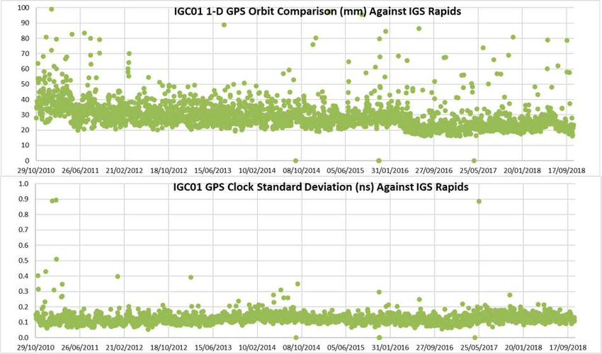
Fig. A.2 shows the orbit and clock performance of the IGC01 combination between 2010 and
2018. The plotted points represent single overall daily RMS values obtained from daily
comparisons of the decoded orbit and clock products against the IGS Rapid solution. Outliers
are generally due to a single poorly performing satellite, typically during the eclipse season.
Publications during the period 2015-2019
Rülke, A., Agrotis, L., Caissy, M., Söhne, W., Stürze, A., Weber, G., (2015), IGS Real-Time
Service: An Open Service for Positioning, Navigation and Timing, 26th IUGG General
Assembly, June 2015, Prague.
Rülke, A., Agrotis, L., (2017), The Real Time Service of the International GNSS Service:
Products, Performance and Challenges, China Satellite Navigation Conference 2017, Shanghai,
China.
Agrotis, L., Schoenemann, E., Enderle, W., Caissy, M., Rülke, A., (2017), The IGS Real Time
Service, GNSS 2017 – Kompetenz für die Zukunft, Schriftenreihe des DVW Band 87/2017.
Figure A1.2 orbit and clock performance of the IGC01 combination between 2010 and 2018.International GNSS Service (IGS) 17 A.2 Antenna Working Group Chair: Arturo Villiger (Switzerland) Overview The IGS Antenna WG establishes a contact point to users of IGS products, providing guidance for antenna calibration issues and for a consistent use of IGS products. It maintains the IGS files related to receiver and antenna information, namely the IGSANTEX file, including satellite antenna and receiver type-mean calibrations. Antenna phase center issues are related to topics such as reference frame, clock products, calibration and monumentation. The Antenna WG therefore closely cooperates with the respective WGs (Reference Frame WG, Clock Product WG, Bias and Calibration WG, Reanalysis WG), with antenna calibration groups, with the AC Coordinator and the ACs for analysis related issues, and with the Network Coordinator concerning maintenance of relevant files. Activities and publications during the period 2015-2019 IGS adopted antenna calibration updates in igs14.atx, in alignment with the IGS14 Reference Frame release. As previously mentioned, these updates include robot calibrations for additional ground antenna types, increasing the percentage of ground stations in the IGS network with absolute calibrations to over 90%, which have translated in increased coordinate accuracy for stations equipped with these antennas. A.3 Bias and Calibration Working Group Chair: Stefan Schaer (Switzerland) Overview The IGS Bias and Calibration WG (BCWG) coordinates research in the field of GNSS bias retrieval and monitoring. It defines rules for appropriate, consistent handling of biases which are crucial for a “model-mixed” GNSS receiver network and satellite constellation, respectively. At present, we consider: P1-C1, P2-C2, and P1-P2 differential code biases (DCB). Potential quarter-cycle biases between different phase observables (specifically L2P and L2C) are another issue to be dealt with. In the face of GPS and GLONASS modernization programs and upcoming GNSS, like the European Galileo and the Chinese Compass, an increasing number of types of biases is expected. Activities and publications during the period 2015-2019 The Bias and Calibration WG continues coordinating research activities related to bias retrieval, analysis, and monitoring. Presently, the group is considering C1W–C1C, C2W–C2C, and C1W–C2W differential code biases (DCB). Potential quarter-cycle biases between different phase observables (specifically between GPS L2W and L2C) are another issue to be dealt with. In the face of GPS and GLONASS modernization programs and upcoming GNSS, such as the European Galileo and the Chinese BeiDou, careful treatment of measurement biases in legacy and new signals becomes more and more crucial for combined analysis of multiple GNSS. In 2016 and 2017, a GNSS bias reprocessing (for GPS/GLONASS) using the recently implemented observable-specific signal bias (OSB) parameterization was carried out at the Center for Orbit Determination in Europe (CODE) for 1994-2016 RINEX data. The outcomes of this reprocessing effort are daily normal-equation (NEQ) files for GPS and GLONASS code bias parameters that are conform to both global ionosphere and clock analysis.
Report of the IAG Vol. 41   Travaux de l’AIG 2015-2019                18

The combination of these daily bias results into a coherent long-term (1994-present)
GPS/GLONASS bias product is another key achievement. Such a bias product is particularly
useful for applications where calibration in the absolute sense are crucial (e.g., for GPS timing,
or atomic clock comparisons). Additionally, CODE’s classic GPS DCB product and the most
resent GNSS bias results are made available using the Bias-SINEX Format Version 1.00.

A.4 Clock Products Working Group
Chair:         Michael Coleman (USA)

Overview

The IGS Clock Product Coordinator forms the IGS timescales based on the clock solutions of
IGS ACs. IGS Rapid and Final products are aligned to these timescales. The Clock Products
WG is the result of a transition from the earlier IGS/BIPM Time Transfer Pilot Project to a
more operational status. Principal products of this WG are the IGS Rapid and Final timescales
as described on the project website.

A.5 Data Center Working Group
Chair:         Carey Noll (USA)

Overview

The IGS DC WG (DCWG) was established in 2002. The DCWG tackles many of the problems
facing the IGS DCs as well as develops new ideas to aid users both internal and external to the
IGS. The direction of the IGS has changed since its start in 1992 and many new WGs, projects,
data sets, and products have been created and incorporated into the service since that time. The
DCWG was formed to revisit the requirements of DCs within the IGS and to address issues
relevant to effective operation of all IGS DCs, operational, regional, and global.

Activities and publications during the period 2015-2019

The DCWG continued to work closely with the IGS IC on several topics, primarily the
implementation of the RINEX Version 3 Transition Plan and the goal of “one network one
archive”. Starting with data from January 01, 2016, the IGS GDCs integrated RINEX V3 data
following the V3 naming conventions into their main, operational directories; this data structure
is now routine at the IGS DCs and the number of stations submitting data in RINEX V3 format
continues to increase. The IGS ACs are now capable of utilizing data in RINEX V3 format and
the IC continues to work with stations to submit their data in this format.

During the 2016-2018 timeframe, significant work was accomplished on this XML site log
metadata activity, particularly work with colleagues implementing GeodesyML. IGS participants
provided feedback on its use and incorporating existing site log metadata into the schema.

Many of the topics addressed by the IGS DCWG have synergies with the IC and thus recent
DCWG splinter meetings during IGS workshops have been held in conjunction with the IC
splinter meeting. Because of the overlap in responsibilities and actions, updates to the IGS
Terms of Reference will move DCWG activities into the IC. A newly identified position, the
IGS DC Coordinator, will work within the IC, and with other IGS WG, to address DC related
items and recommendations.
International GNSS Service (IGS)                          19

A.6 GNSS Monitoring Group (IGMA)
Chair:         Tim Springer (Germany)

Overview

The GNSS landscape is undergoing a fundamental transition with the development of new
satellite navigation systems. Furthermore, existing systems are being modernized and new
signals and frequencies becoming available. To optimally exploit the benefits of multi-GNSS,
users require homogeneous common monitoring of the performance of individual constellation
and signals, to verify service commitments are met and to ensure public confidence in GNSS
service provision and interoperability. Based on this, the ICG recommended at the ICG-10
meeting in Boulder 2015 that the IGMA Task Force and IGS initiate a joint Trial Project to
demonstrate a global GNSS monitoring and assessment capability, utilizing existing resources
and infrastructure and avoiding duplications.

The Joint GNSS Monitoring WG was formed by the IGS GB at its meeting in December 2016
in San Francisco in order to install, operate and further develop the IGS GNSS Monitoring and
Assessment Pilot Project jointly with the International GNSS Monitoring and Assessment
(IGMA) Task Force of the United Nations Office of Outer Space Affairs, International
Committee on GNSS (UNOOSA-ICG).

A.7 Ionosphere
Chair:         Andrzej Krankowski (Poland)

Overview

The Ionosphere WG started the routine generation of the combine Ionosphere Vertical Total
Electron Content (TEC) maps in June 1998. This has been the main activity so far performed
by the four IGS Ionosphere Associate ACs (IAACs): CODE, ESOC, JPL, and UPC (Technical
University of Catalonia, Barcelona, Spain). Independent computation of rapid and final TEC
maps is used by each ACs: Each IAACs compute the rapid and final TEC maps independently and
with different approaches including the additional usage of GLONASS data in the case of CODE.

A.8 Multi-GNSS

Chair:         Oliver Montenbruck (Germany)

Overview

The main activity of the Multi-GNSS WG (MGWG) is MGEX; which aims at the integration of
the evolving global and regional satellite navigation systems Galileo, BeiDou, QZSS, and NavIC
into the IGS data archives and operational products. Multi-GNSS observation data are provided
by a global tracking network that is fully integrated into the IGS network since 2016. The MGEX
ACs use these observations to generate multi-GNSS products, in particular orbits and clocks.

Activities and publications during the period 2015-2019

MGEX started as the multi-GNSS experiment in 2011 and its status was changed to a pilot
project in the beginning of 2016. A comprehensive overview of the organizations contributing
Report of the IAG Vol. 41   Travaux de l’AIG 2015-2019           20

to MGEX as well as the various products and their quality is given in Montenbruck et al. (2017).
The MGEX ACs generating orbit and clock products are given in the table below.

 Table A8.1 RTS Combination Products

   Institution                                                   Constellations
   Centre National d’Etudes Spatiales, Collecte Localisation     GPS+GLO+GAL
   Satellites (CNES/CLS)
   Center for Orbit Determination in Europe (CODE)               GPS+GLO+GAL+BDS2+QZS
   Deutsches GeoForschungsZentrum (GFZ)                          GPS+GLO+GAL+BDS2+QZS
   Japan Aerospace Exploration Agency (JAXA)                     GPS+GLO+QZS
   Shanghai Observatory (SHAO)                                   GPS+GLO+GAL+BDS2
   Technische Universität München (TUM)                          GAL+BDS2+QZS
   Wuhan University                                              GPS+GLO+GAL+BDS2+BDS3+QZS

Solar radiation pressure is the largest error source for orbit determination of GNSS satellites.
Early analysis of Galileo orbits generated by the MGEX ACs revealed systematic orbit-periodic
effects (Steigenberger et al. 2015). These errors could be significantly reduced by introducing
an a priori model considering the elongated shape of the Galileo satellites (Montenbruck et al.
2015) or more sophisticated empirical orbit models (Prange et al. 2017).

Metadata like satellite mass, center-of-mass coordinates, and surface properties are important
the generation of accurate GNSS products (Montenbruck 2017). Subsets of satellite metadata
were recently released by the European GNSS Agency for Galileo (https://www.gsc-
europa.eu/support-to-developers/galileo-satellite-metadata) and Cabinet Office for QZSS
(http://qzss.go.jp/en/technical/qzssinfo/index.html). The MGWG developed an extension of the
SINEX format for satellite metadata and maintains a draft version of the IGS satellite metadata
file (http://mgex.igs.org/IGS_MGEX_Metadata.php).

References

Prange L, Orliac E, Dach R, Arnold D, Beutler G, Schaer S, Jäggi A (2017) CODE’s five-
   system orbit and clock solution – the challenges of multi-GNSS data analysis, J Geod
   91(4):345–360, DOI: 10.1007/s00190-016-0968-8
Steigenberger P, Hugentobler U, Loyer S, Perosanz F, Prange L, Dach R, Uhlemann M, Gendt
   G, Montenbruck O, (2015) Galileo Orbit and Clock Quality of the IGS Multi-GNSS
   Experiment, Adv Space Res 55(1):269–281, DOI: 10.1016/j.asr.2014.06.030
Montenbruck O, Steigenberger P, Hugentobler U (2015) Enhanced Solar Radiation Pressure
   Modeling for Galileo Satellites, J Geod 89(3):283–297, DOI: 10.1007/s00190-014-0774-0
Montenbruck O, Steigenberger P, Prange L, Deng Z, Zhao Q, Perosanz F, Romero I, Noll C,
   Stürze A, Weber G, Schmid R, MacLeod K, Schaer S. (2017) The Multi-GNSS Experiment
   (MGEX) of the International GNSS Service (IGS) – Achievements, Prospects and
   Challenges, Adv Space Res 59(7):1671-1697, DOI: 10.1016/j.asr.2017.01.011
Montenbruck O (2017) IGS White Paper on Satellite and Operations Information for
   Generation of Precise GNSS Orbit and Clock Products

A.9 Precise Point Positioning with Ambiguity Resolution
Chair:          Simon Banville (Canada)

Overview

Precise satellite orbit and clock corrections produced by the IGS are used by many for the
purpose of computing precise point positioning (PPP) solutions. For 24-hour solutions in static
International GNSS Service (IGS)                            21

mode, PPP can provide millimeter-level accuracies for all components (latitude, longitude and
height). Since PPP processes undifferenced observations, it also provides useful information on
other error sources affecting GNSS observations such as receiver clocks, tropospheric delays
and slant ionospheric delays.

For about a decade now, techniques were developed to fix undifferenced ambiguities in PPP.
Similar to a network solution, ambiguity resolution provides improved estimates for user
parameters. Studies have demonstrated a 30% improvement in the longitude component,
enhanced receiver clock stability estimates, and reduced errors in PPP-derived atmospheric
delays. PPP with ambiguity resolution (PPP-AR) can also significantly improve the accuracy
of short observation sessions, which is especially beneficial for fieldwork in many industries.

With PPP-AR having matured sufficiently since its inception, and with more IGS ACs
producing products enabling PPP-AR (currently: CNES, NRCan, Wuhan and CODE), the
timing is right for the IGS to start investigating a combined version of these products. Different
from standard clock products produced by the IGS, PPP-AR products only retain their
consistency when considering simultaneously both the satellite clock and bias (code and phase)
corrections. There is, however, no impact on the combined orbit products.

The PPP-AR WG will investigate the development of a modernized combination process taking
into consideration both satellite clocks and biases. Improvements to the current clock
combination process shall also be considered, such as: satellite attitude during eclipse periods,
day boundary discontinuities, and the inclusion of multiple GNSS constellations. It should also
be noted that all ACs can contribute to such a clock/bias combination, although the combined
phase-bias products would be determined solely from ACs contributing PPP-AR products. The
goal of the PPP-AR WG is, therefore, to analyze the feasibility and benefits of having the IGS
adopt a modernized clock/bias combination process.

A.10 Real Time Service
Chair:         André Hauschild (Germany)

Overview

The Real Time Service (RTS) expands the capacity of the IGS to support applications requiring
real-time access. It utilizes a global receiver network and provides infrastructure for data and
product dissemination. Analysis products include individual ACs as well as combination
solutions. There is a large variety of potential applications for the service with a strong focus
on scientific and educational applications.

A.11 Reference Frame
Chair:         Paul Rebischung (France)

Overview

The collective effort of the WG participants is to generate the official IGS station coordinates
and velocities, Earth Rotation Parameters (ERPs), geocenter estimates and other terrestrial
frame-related parameters along with the appropriate covariance information. The estimated
parameters are aligned to the ITRF. The group strives for consistency, reliability, accuracy and
timeliness of the above products.
Report of the IAG Vol. 41 Travaux de l’AIG 2015-2019 22
The WG also specifies and selects globally distributed sets of GNSS stations from the ITRF
solutions to realize the successive IGS Reference Frames (RF). New RF realizations are issued
at irregular intervals, usually synchronized to new ITRF releases. The reliability and
consistency of individual RF stations are continuously monitored and occasional updates
announced to users.
Activities and publications during the period 2015-2019
Besides a continuous quality monitoring of the operational IGS terrestrial frame combination
products, the main achievements of the WG during the period 2015-2019 were the following:
IGS contribution to ITRF2014. The IGS contribution to ITRF2014 is based on the products
from the second IGS reprocessing campaign (repro2). A total of 9 ACs contributed to the repro2
campaign and provided daily terrestrial frame (SINEX) solutions among other products. The
individual AC contributions were combined into official IGS repro2 SINEX solutions, named
“ig2”, which constitute the IGS contribution to ITRF2014. A complete description of the repro2
SINEX combination methodology and results can be found in Rebischung et al. (2016;
https://doi.org/10.1007/s00190-016-0897-6).
IGS14/igs14.atx framework. After the latest release of ITRF2014 (Altamimi et al., 2016;
https://doi.org/10.1002/2016JB013098) was published in January 2016, the Reference Frame
WG and the Antenna WG prepared the IGS realization of ITRF2014, IGS14, and the associated
set of satellite and ground antenna calibrations, igs14.atx. This preparation included:
the selection of the most suitable reference frame (RF) stations from the complete set of
GNSS stations in ITRF2014, and the design of a well-distributed core network of RF
stations for the purpose of aligning global GNSS solutions,
updates of the ground antenna calibrations of various antenna types and assessment of
the impact of these updates on station coordinates,
the re-evaluation of the radial components of all GPS and GLONASS satellite antenna
phase center offsets.
The operational IGS products were switched from the previous IGb08/igs08.atx to the new
IGS14/igs14.atx framework on GPS week 1934 (29 January 2017). The switch was announced
to the community in [IGSMAIL-7399], together with details about the elaboration of IGS14
and igs14.atx and their impact on user results.
Further details on the WG activities during the period 2015-2019 can be found in the yearly
IGS technical reports.
A.12 RINEX
Chair: Ken MacLeod (Canada) through May 2019. Vacant as of May 2019
Overview
The IGS RINEX-WG was established in December of 2011 to update and maintain the RINEX
format to meet the needs of the IGS and the GNSS Industry. Since the RINEX format is widely
used by the GNSS industry it was decided that it should be jointly managed by the IGS and
RTCM-SC104. As a result, the working group consists of both IGS and RTCM-SC104 industry
members. Document approval will follow the IGS/RTCM-SC104 consensus-based approach and
majority voting will be used if a consensus cannot be reached in a reasonable amount of time.
RINEX documents will continue to be freely distributed both by the IGS and RTCM-SC104.International GNSS Service (IGS) 23 RINEX 2.1X is currently the primary archival format used within the IGS and the GNSS industry. However, since RINEX 2.1X was designed in the mid 1990s, primarily to support GPS, it has proven difficult to extend RINEX 2.1X to support new GNSS constellations and signals. As a result of the shortcomings of RINEX 2.1X, RINEX 3.0x was designed to provide generic and systematic support for GNSS constellations, signals and observations. Given the needs of both the IGS and GNSS communities and the strengths of RINEX 3.0X, the IGS plans to support RINEX 3.0X. It is understood by the IGS that the transition from RINEX 2.1X to 3.0x has to be done in partnership with the GNSS community. One of the first steps in this transition occurred in 2009 when the IGS joined the RTCM-SC104. Since joining RTCM-SC104 the IGS has contributed to the development of an open, generic, high precision and multi-GNSS binary observation format called RTCM-Multiple Signal Messages (RTCM-MSM). The RTCM-MSM format supports the creation of fully defined, phase aligned RINEX 3.0x observations files. To support the transition to RINEX 3.0X the IGS/RTCM-SC104 RINEX WG is encouraging and supporting the development of open source software tools that will convert RTCM-MSM to RINEX 2.1X and 3.0X formats and provide data quality control measures. A.13 Space Vehicle Orbit Dynamics Chair: Tim Springer (Germany) Overview Several groups and individuals within the IGS community are working on topics related to spacecraft orbit dynamics and attitude modelling. Recent progress in these areas show there is scope to improve the accuracy of the orbits and observable modelling through these studies that will be of direct benefit to IGS products and users. Moreover, given the emergence of new constellations the IGS will need spacecraft specific force and attitude models in order to fully exploit the availability of the new signals. The Space Vehicle Orbit Dynamics WG formalizes and coordinates the efforts of the individual groups in this area. A.14 Tide Gauge (TIGA) Chair: Tilo Schöne (Germany) Overview The Tide Gauge Benchmark Monitoring WG (TIGA) of the IGS continues its support for climate and sea level related studies and organizations concerned herewith (e.g., GGOS, OSTST, UNESCO/IOC). The TIGA WG provides vertical geocentric positions, vertical motion and displacements of GNSS stations at or near a global network of tide gauges and works towards establishing local geodetic ties between the GNSS stations and tide gauges. To a large extend the TIGA WG uses the infrastructure and expertise of the IGS. The main aims of the TIGA WG are: 1. Maintain a global virtual continuous GNSS Tide Gauge network 2. Compute precise coordinates and velocities of GNSS stations at or near tide gauges. Provide a combined solution as the IGS-TIGA official product. 3. Study the impacts of corrections and new models on the GNSS processing of the vertical coordinate. Encourage other groups to establish complementary sensors to improve the GNSS results, e.g., absolute gravity sites or DORIS. 4. Provide advice to new applications and installations.
You can also read