Issue Paper An inventory of new technologies in fisheries - OECD.org
←
→
Page content transcription
If your browser does not render page correctly, please read the page content below
2017                      Greening
                          the         21 & 22 November
#GGSD
                          Ocean          OECD, Paris
Forum                     Economy
Part of OECD Ocean Economy Week

Issue Paper
                             An inventory of
                           new technologies
                                 in fisheries

                                        Pierre Girard
                                       Maritime Survey
                                            and
                                      Thomas Du Payrat
                                     Odyssée Development
Challenges and opportunities in using new technologies to monitor

                                     Sustainable fisheries

        OECD GREEN GROWTH AND SUSTAINABLE DEVELOPMENT FORUM

The Green Growth and Sustainable Development (GGSD) Forum is an OECD initiative aimed at
providing a dedicated space for multi-disciplinary dialogue on green growth and sustainable
development. It brings together experts from different policy fields and disciplines and provides
them with an interactive platform to encourage discussion, facilitate the exchange of knowledge and
ease the exploitation of potential synergies. By specifically addressing the horizontal, multi-
disciplinary aspects of green growth and sustainable development, the GGSD Forum constitutes a
valuable supplement to the work undertaken in individual government ministries. The GGSD Forum
also enables knowledge gaps to be identified and facilitates the design of new work streams in order
to address them.

                             Authorship & Acknowledgements

This issue note was prepared for the 2017 GGSD Forum to steer discussion around the theme “An
inventory of new technologies in fisheries: challenges and opportunities in using new technologies to
monitor sustainable fisheries”. This issue note was prepared by Pierre GIRARD, Consultant for
Maritime Survey (France) and Thomas DU PAYRAT, Odyssée Development (France). This issue note
benefited from comments of several OECD staff members including Antonia LEROY, Dulika
RATHNAYAKE, Jaco TAVENIER, Franck JESUS, Roger MARTINI, Claire JOLLY, Ron STEENBLIK as well as
Kumi KITAMORI. The authors are grateful to Antonia LEROY and Dulika RATHNAYAKE for their
editorial guidance. The note was produced with financial support of Norway. The opinions expressed
and arguments employed herein do not necessarily reflect the official views of the OECD or of its
member countries.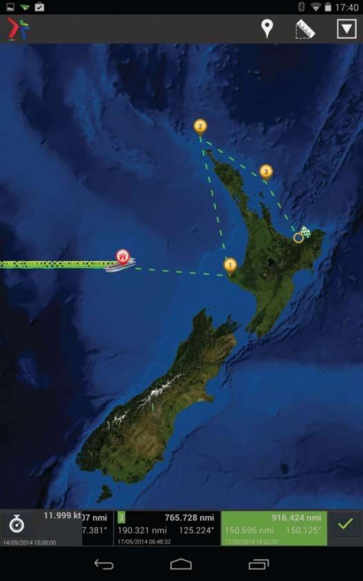
Table of contents

List of Abbreviations & Glossary ............................................................................................................. 3
Executive Summary ................................................................................................................................. 4
1.Setting the scene.................................................................................................................................. 5
Figure 1: International organisations involved in IUU and related fish crimes issues ........................... 6
2.Inventory of innovative monitoring technologies ............................................................................... 7
   2.1 Current use of new technologies in fisheries................................................................................ 7
       2.1.1. Collaborative tools ................................................................................................................ 7
       2.1.2. Non-collaborative tools....................................................................................................... 12
   2.2 Other technological development in fisheries ............................................................................ 12
       2.2.1. Big data technologies for monitoring of fisheries............................................................... 13
       2.2.2. Blockchain technologies...................................................................................................... 14
       2.2.3 Smart weighing system at sea ............................................................................................. 14
       2.2.4 Drones (also named as Un-Manned Vehicle) ...................................................................... 14
   2.3 Gathering and interpreting data from new technologies: the Fisheries Monitoring Centre ..... 16
   Figure 2: Fisheries Monitoring Centre and monitoring tools ........................................................... 16
3.Implications for governments policies: The pros and cons ............................................................... 18
   Figure 3 Use of innovative monitoring technologies at various policy stages.................................. 19
   3.1 Encouraging use of product certification, e.g. eco-labelling ...................................................... 19
   3.2 Strengthening fishing gear standards for selectivity and ecosystem preservation .................... 19
   3.3 Monitoring Marine Protected Areas ........................................................................................... 20
   3.4 Modelling the environmental impact of the fishing activity ...................................................... 20
   3.5 Improving market based instrument for fisheries ...................................................................... 21
   3.6 Support traceability in a well-functioning markets .................................................................... 21
   3.7 Enhance capacity to make the best use of new technologies .................................................... 21
4.Recommendations for future research ............................................................................................. 23
5.References ......................................................................................................................................... 25
Appendix ............................................................................................................................................... 26

                                                                            2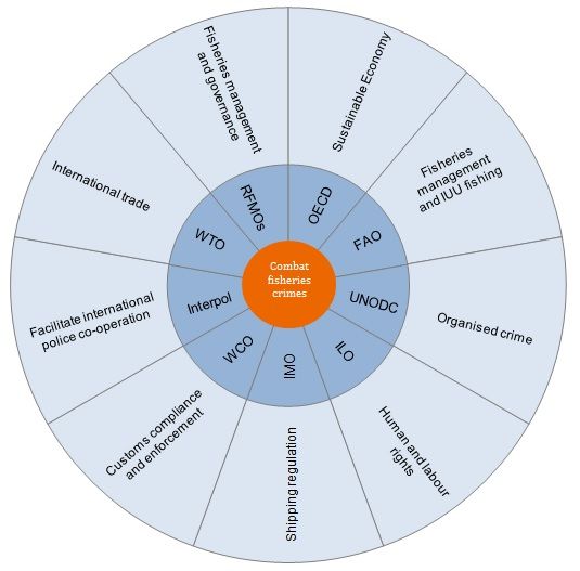
List of Abbreviations & Glossary

AFMA           Australian Fisheries Management Authority
AIS            Automatic Identification System
CFP            Common Fisheries Policy
DG MARE        Directorate General for Maritime Affairs and Fisheries (EU)
EEZ            Exclusive Economic Zone
EMSA           European Maritime Safety Agency
ERS            Electronic recording and reporting system
FLUX           Fisheries Language for Universal eXchange
FMC            Fishery monitoring centre
FOCUS          Fisheries Open Source Community Software
GNSS           Global Navigation Satellites Systems (including via GPS)
GPRS           Global Packet Radio System (GSM data support)
GPS            Global Positioning System
GSM            Global System for Mobile communication
IMO            International Maritime Organization
IOT            Internet of Things
IUU            Illegal, unreported and unregulated (fishing)
JRC            Joint Research Centre
MCS            Monitoring, Control & Surveillance
MPA            Marine Protected Area
NM             Nautical mile
RFID           Radio-frequency identification Device
RFMO           Regional Fisheries Management Organisation
UN/CEFACT      United Nations Centre for Trade Facilitation and Electronic Business Union
UNCLOS         United Nations Convention on the Law of the Sea
VHF            very high frequency
VMS            Vessel Monitoring System
VTS            Vessel Traffic Services

Term        Definition
Hacking     gaining of access (wanted or unwanted) to a computer and viewing, copying, or creating data
            without the intention of destroying data or maliciously harming the computer
Spoofing    hacking that imitates another person software program, hardware device, or computer, with
            the intentions of bypassing security measures
Deception   Deception technology is a category of security tools and techniques that is designed to
            prevent an attacker who has already entered the network from doing damage.

                                                    3
Executive Summary

The 1982 UN Convention on the Law of the Sea (UNCLOS) sets out new responsibilities for coastal
States regarding the use of resources in their exclusive economic zones (EEZs). Those responsibilities,
in many cases, establish the need for both economic development and effective control of a
country's marine resources, including fisheries. States are committed to the sustainable exploitation
of fish stocks, through better management and conservation of fisheries, ecosystem-based
approaches such as marine protected areas (MPA), and reducing illegal, unreported and
unregulated (IUU) fishing.
New information and monitoring technologies are potential game-changers for fisheries
management and can be of help in achieving green growth of the sector. Application of new
technologies has allowed governments to collect more data on fish stocks, better monitor, enforce
and evaluate the environmental impacts of fisheries activities and improve the effectiveness of
policies to sustainably manage fisheries.
To this end, there are many recent technological developments. Such technologies can be
collaborative, i.e. involving more than one stakeholder groups along the value chain or non-
collaborative which are set up by governments to monitor the fisheries sector. These include the
increased computing power of handheld devices; the proliferation of user-friendly Global Positioning
System (GPS) and Global Navigation Satellites Systems (GNSS) applications; increased capacity for
“big data” storage, sharing, and analysis; variety and improved durability of drones and low-
maintenance radar stations; accessibility and accuracy of satellite imagery; continuous
improvements in on-board digital cameras and recorders; expanded use of Automatic Identification
Systems (AIS) and Vessel Monitoring Systems (VMS), and the internet at sea.
This paper examines some of these technologies used in maritime fisheries management, both
current and emerging, so as to better understand how policies can influence their development and
use and vice-versa. It will help governments to consider how they can adapt and improve their
policies, regulations, their enforcement and compliances.
The future of fisheries management will not depend on any single technological innovation. A whole
ecosystem of new technologies that complement and communicate with each other will help in
shaping the toolbox used by policy makers for fish stock management, MPA implementation and
fight against IUU fishing.

                                                  4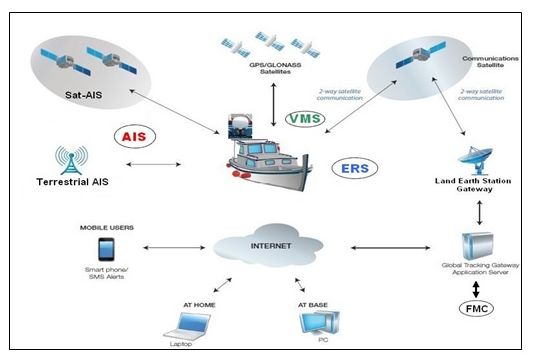
1. Setting the scene
SUMMARY
Technological and digital advances now allow innovative monitoring equipment to
better manage fish stocks, which are used in all stages of the value chain.
New technologies, including Big Data, the internet of things (IoT), sensors, robotics,
data storage and transmission will become more compact and cheaper thus
encouraging their use.
However, the wider use of these technologies is still limited by their cost,
increasingly complex data requirements, challenges in sharing such data among
fisheries management authorities and the limited numbers of individuals trained to
use these tools.
Fisheries represent an important source of food and livelihood for millions of people around
the world. However, based on Food and Agriculture Organization (FAO) analysis of assessed
commercial fish stocks, the share of fish stocks within biologically sustainable levels has
decreased since the 1970s and is only starting to recover now. 1 IUU fishing is estimated at
15% of total catches, representing a value of EUR 24 billion annually. 2
Globalisation has provided opportunities for criminal networks to expand the scope and
scale of IUU fishing operations, sometimes in combination with other crimes such as drug
trafficking, forced labour, tax crimes and even financing of terrorist activities (UNODC, 2011;
OECD, 2016).
International organisations support governments in their fight against IUU fishing (Figure 1)
but this activity persists partly due to the difficulty in monitoring all seas in real time. As fish
stocks become scarcer, fish quotas tend to decline further for law-abiding vessels thereby
creating unfair competition from vessels fishing illegally.
1
In its latest report of The State of World Fisheries and Aquaculture 2016, the FAO notes that “good progress is being made
in reducing fishing rates and restoring overfished stocks and marine ecosystems through effective management actions in
some areas”. According to the FAO, 64% of the previously overfished stocks in United States waters had been rebuilt or
were showing significant success by 2013. Government-managed Australian fisheries ended overfishing in 2014. Namibia
rebuilt its iconic hake fishery, and Mexico restored abalone stocks.
2
For a detailed definition, please see the United Nations Food and Agriculture Organization (FAO) International Plan of
Action Against illegal, unreported and unregulated fishing.
5Figure 1: International organisations involved in IUU and related fish crimes issues
Source: Leroy A. and R. Akam (2016)
Technological and digital advances these days allow innovative monitoring equipment to be
attached to traditional sampling gear and collect more data such as ecosystem information,
in order to better manage fish stocks and tackle IUU fishing. For instance, visual inspections
in complex habitats using imaging systems installed on robotic and autonomous underwater
vehicles (AUVs) can contribute to the advancement of marine science and better knowledge
of fish stocks. In addition, advanced analytics, AIS and high-resolution imagery coming from
satellite systems have made a significant change in how countries monitor vessel movements
outside of their 12-nm territorial waters. Governments, businesses and individuals are
increasingly moving towards these new tools.
As the diffusion and use of new technologies increase the cost of monitoring, surveillance
and control at sea, data collection, storage and processing on activities and marine
ecosystems continues to decline drastically. However, the wider use of these new
technologies is still often limited by the cost of satellite imagery and equipment for smaller
vessels, gaps in the interoperability of data-sharing software and hardware, and limited by
the number of individuals adequately trained to use these tools. In addition, as fisheries
management becomes more holistic, data requirements and analyses become increasingly
complex.
This paper gives an overview of new and promising technologies while discussing the
potential of innovative monitoring technologies to better manage fish stocks, MPA and IUU
fishing. Then, the paper discusses public policy implications for their adoption for green
growth.
62. Inventory of innovative monitoring technologies
SUMMARY
Collaborative monitoring, control and surveillance (MCS) tools rely on the willingness of a
given vessel’s captain; non-collaborative tools rely on the decisions taken by the authorities
in control (on when and where the vessel is monitored).
Collaborative tools include Vessel Monitoring System (VMS) and Automatic Identification
System (AIS).
Non-collaborative tools include optical or radar satellites.
New data processing technologies in fisheries include: big data, block chain, smart weighing
at sea, Radio-frequency identification (RFID), smartphones for monitoring, artificial
intelligence, drones, and on-board cameras.
New technologies can provide data that are reliable and useful to policy makers. This chapter
provides an inventory of the current use and development of these technologies along with a
description of how a fisheries monitoring centre (FMC) works in order to process and gather
various data from all these new tools.
2.1 Current use of new technologies in fisheries
MCS is now a standard part of fishing operations and fisheries management. 3 To understand
the incentives and actions motivated by MCS, a distinction will be drawn between
collaborative and non-collaborative tools. The main difference is that collaborative tools rely
on the willingness of the vessel’s captain to participate in the system. For example, a captain
can switch off their VMS or AIS devices, though they risk a penalty. Non-collaborative MCS
tools rely on solutions like satellite imagery, where captains are not in control of reporting
the time and place of fishing activities, as this is observed by satellites.
2.1.1. Collaborative tools
The main collaborative tools are VMS and AIS, which were first built on existing satellite and
radio frequency technologies and electronic recording and reporting systems commonly
referred to as E-Logbooks, in order to distinguish them from paper-based logbooks. 4
a. Vessel Monitoring Systems (VMS)
VMS was originally a satellite-based system that provided data on the time-stamped
location, course and speed of vessels to fisheries authorities at regular intervals (every two
hours or 12 times per day). 5
Prior to the 1980s, the only way to communicate with vessels beyond the horizon was by
using satellites. In 1978, the members of the International Maritime Organization (IMO)
3
As defined by [FAO 1981]: “Monitoring refers to the collection, measurement and analysis of fishing activity including, but
not limited to, catch, species composition, fishing effort, bycatch, discards and area of operation. Control involves the
specification of the terms and conditions under which resources can be harvested. Surveillance involves the regulation and
supervision of fishing activity to ensure that national legislation and terms, conditions of access and management
measures are observed.”
4
Operators of commercial fishing vessel and some recreational charter fishing vessel maintain on board the vessel an
accurate and complete record of catch, effort, and other data on a form, called a logbook.
5
https://ec.europa.eu/fisheries/cfp/control/technologies/vms_en.
7created the International Mobile Satellite Organization (later re-named as Inmarsat) to
improve safety at sea and provide the maritime community with satellite telecommunication
services. It launched the first satellite constellation to provide VMS services, Inmarsat. 6 In
the 1990s, the Argos constellation provided a solution to environmental monitoring and later
for VMS. In 2000, Iridium entered the VMS market. Table 2 in Annex provides a comparison
of these systems.
In the early 2000s, Eastern Adriatic riparian countries sought an alternative to satellite-based
VMS required by the Common Fisheries Policy (CFP). 7 The Global Packet Radio System
(GPRS) 8 network was identified as an alternative and adopted by other European countries
such as Greece and the United Kingdom. A new generation of hybrid transceivers using both
satellite modems (first Iridium, then Inmarsat) was introduced coupled with a GPRS modem.
This enabled fishing vessels to communicate cheaply at a distance of six to eight nautical
miles from the coastline, before switching to satellite coverage over this virtual limit. By
doing so, fishing vessels could take advantage of cheaper global systems for mobile
communication (GSM).
VMS are implemented nearly worldwide with various ranges of transceivers. Some countries
(e.g. Algeria) only equipped tuna-seiner vessels or specific vessels for fishing in the high seas
in order to comply with recommendations by regional fisheries management organisations
(RFMO). Hybrid technology allowed some coastal states (e.g. Albania and Croatia) to install
VMS transceivers at lower costs than satellite-only technology.
Collecting data on vessel movements can improve management and compliance with
fisheries policies by allowing governments to collect near real-time observations of fishing
vessel positions. VMS map the spatial distribution of fishing vessels and calculate fishing
intensity. For instance, when fishing is prohibited in MPA, VMS information can help steer
fishers away from the designated areas. In addition, VMS can be a cost-effective tool for
establishing zoning for marine spatial planning (MSP). For instance, spatial fishing data can
be incorporated in conservation planning processes to meet the conservation goals of MPAs
while minimising loss of revenues for fishers. 9
However, the scale of VMS remains a challenge as the data collection on vessel movements
currently only applies to vessels over 15m in length or 300 Gt in weight. Some 80% of fishing
vessels worldwide are currently not fitted with VMS. Since only small-scale vessels measuring
less than 15m are allowed to fish in MPAs, they therefore remain unmonitored. In addition,
as for all collaborative tools, vessel captains may decide to turn off their VMS transponder
risking penalties if caught.
Open-source sharing may be the future of VMS. The United Nations Centre for Trade
Facilitation and Electronic Business (UN/CEFACT) Standards Framework and the Fisheries
6
This used standard C VMS data in 56-bit (7 bytes) packets.
7
The EU has accepted this policy with regard to some call of offer without any modification to the CFP. (cf.
EuropAid/129568/C/Sup/AL).
8
GPRS – Global Packet Radio Service is the GSM network counterpart for data transmission only (not voice).
9
Gonzalez-Mirelis G, M. Lindegarth and M. Sköld (2014), “Using Vessel Monitoring System Data to Improve Systematic
Conservation Planning of a Multiple-Use Marine Protected Area, the Kosterhavet National Park (Sweden)”, Ambio,
Vol.43/2, pp. 162-174, http://dx.doi.org/10.1007/s13280-013-0413-7.
8Open Source Community Software (FOCUS) recently established a community whose
purpose is to create and maintain free software for the management and preservation of
fisheries resources.
In April 2015, the Union Vessel Monitoring System (Union VMS) was created as an open-
source project funded by the Swedish Agency for Water Management and the European
Commission’s Directorate General for Maritime Affairs and Fisheries and Fisheries (DG
MARE). The objective of Union VMS is to reduce the cost of developing, implementing and
promoting collaboration among EU Member States. 10 Reports can be viewed, exported and
printed in Union VMS to ensure responsible and legitimate fishing. A small number of EU
member states such as Greece, Italy, Malta, and Sweden are currently testing this open-
source software.
The Union VMS is currently an European initiative, but is anticipated to be more widely
adopted. DG MARE expects that EU Member states, as well as third-party states, will not be
reluctant to equip their fishing vessels with MCS collaborative tools (i.e. VMS transceivers, AI
systems, FMCs and ERS). 11
When it comes to lowering costs of VMS for small-scale fishing vessels, the dual or hybrid
options should be considered, such as for GSM coastal coverage.
b. Automatic Identification System (AIS)
AIS is a ship-reporting system based on messages broadcasted by vessels carrying
transponders. It was developed primarily as a tool for maritime safety to avoid vessel
collision by Vessel Traffic Services (VTS) and as a means for coastal states to receive
information on vessels operating near their coasts. AIS transponders send and receive
signals, using a very high-frequency (VHF) transmitter, broadcast to receiver devices on other
ships or to land-based systems. By sending and receiving regular communications about their
identity and course, vessels can avoid collisions and navigate safely in low visibility.
AIS provide an opportunity for fisheries management and enforcement as many countries
now require AIS for safety and to reduce costs. An AIS message primarily delivers security
and safety data (e.g. a vessel’s position relative to other vessels near or in relation to the
nearest ground station) as well as information about the crew. Associated with a VMS and
radar, these technologies can identity a vessel (if it is fishing in a forbidden zone) without
giving away its position. VMS delivers 4 major data: latitude, longitude, Speed and direction
as the AIS. Additionally, the AIS provides speed in relation to the bottom of the sea. When
used together, they can detect whether the vessel is fishing (slowing down to 1 or 2 nautical
miles per hour) in a specific area or in transit (moving at 7 to 8 nautical miles per hour). In
addition, Radar-Sat monitoring can be used to retrace the trajectory of a ship and look for
evidence of illegal trans-shipment, which may be confirmed by AIS or VMS data.
10 https://www.havochvatten.se/en/swam/eu--international/international-cooperation/union-vms/about-
union-vms.html
11
See https://ec.europa.eu/info/european-commissions-open-source-strategy_en#softwarestrategy Open-
Source Software Strategy 2014-2017: “For the internal development of new information systems, in particular
where deployment is foreseen by third parties outside the EC infrastructure, OSS shall be the preferred choice
and used whenever possible”.
9AIS information is a critical tool for coast guards to enhance Maritime Domain Awareness
(MDA) in support of all Coast Guard missions. Since May 2014, countries have authorised the
use of AIS data and in the EU, AIS applies to all vessels above 15 metres in length.
The drawback of AIS is its limited range. AIS signal transmission is limited by the curvature
of the Earth to approximately 40 nautical miles depending on the ground station height,
approximately the visual horizon line. Beyond 40 nautical miles, AIS satellites take over, but
these can be saturated depending on the area and the traffic intensity causing loss of
messages. The European Space Agency (ESA) is promoting a European-based SAT-AIS system
in partnership with the European Maritime Safety Agency (EMSA). 12 Two main stakeholders
(exactEarth Ltd. and ORBCOMM) share this market today.
Since 2004, the IMO requires AIS transponders to be installed on-board most vessels,
according to the SOLAS (Safety of Life at Sea) convention, but as for VMS this only applies to
ships of 300 gross tonnes or more.
As AIS is a self-reporting system, the main drawbacks are its unreliability and vulnerability
to manipulation. In this context, the main issues to be addressed are the following: (i) AIS
messages can be erroneous, because a part of the information is entered manually by the
crew, both at the initialisation of the system for permanent data (e.g. the name of the
vessel) and with data related to each journey (e.g. vessel’s destination); (ii) AIS reports can
be falsified (or spoofed) as a deceptive behaviour since AIS is a broadcast system that
sends information, it can be easily intercepted by anyone not only by coastal authorities;
(iii) a vessel can turn off its AIS transponder so as to engage in illegal activities.
Despite its current weaknesses in term of data security, further consideration should be
given to AIS (both satellite and terrestrial) functions in order to: (a) improve defences against
spoofing 13 (hardware and software based); (b) grant major development to improve anomaly
detection algorithms to identify AIS on-off switching; and (c) promote VHF Data Exchange
System (VDES) for a secured future AIS. 14
c. Electronic Logbook or ERS
Electronic Recording and Reporting System (ERS) is commonly referred to as E-Logbook, in
comparison with former paper-based logbooks. E-logbook data (logs records) contribute to
better management of fish stocks by keeping track of catches (origin and volume) and gear
used. 15
ERS collects information on species, volume and areas of catches, important data for
fisheries. On-board logbooks are mandatory requirements for high sea fishing vessels in
some RFMOs such as the Indian Ocean Tuna Commission. ERS can demonstrate when
catches haven’t been reported correctly and can revolutionise the entire process of data
12
SAT-AIS bonus is that can be implemented without additional hardware upgrades – vessels and terrestrial
stations are already outfitted with AIS technology.
13
see Glossary.
14
Major AIS-related threats are “spoofing” either due to software or RF (Radio Frequency) interference. See
Trend Micro Research paper “A security evaluation of AIS” ©2014 by Marco Balduzzi, Kyle Wilhoit and
Alessandro Pasta.
15
NOAA (US National Oceanic and Atmospheric Administration) currently uses the term Record Keeping and
Reporting (R&R).
10collection and reporting during fishing operations. When properly deployed and used, ERS
could transform the entire commercial fleet into a provider of good quality data and change
the way fish resources are managed.
ERS will make it possible to trace catches back to the individual fishing operation, improve
knowledge of fisheries and thus the efficiency of the sector as well as improving control of
fishing operations and enforcement (MPA-regulated or otherwise). 16 Collecting data from
VMS and AIS in addition to e-logbooks gives a more complete view of fishing activities that
can help assess the impact of fishing activity on the ecosystem.
Australian fishers have been using an electronic logbook since 2011 to report catch and
effort data to Australian Fisheries Management Authority (AFMA) and this is proving to have
real benefits for both AFMA and the industry. 17 Canada is developing electronic logbook
client applications (ELOGS), enabling fish harvesters to enter and transmit fishing catch and
effort information to the Department of Fisheries and Oceans using electronic files. Phase 1
of this initiative is expected to start in summer 2018. E-Logbook development in China is in
progress, relying on local systems, either on Chinese satellites constellation (i.e. Beidou,
which also plans to begin serving global customers upon its completion in 2020) or coastal
network coverage.
Remaining challenges lie in verifying and harmonising ERS data. The coupling of logbook
and VMS data has already proven powerful for describing the spatial distribution of the
marine biota habitat at a much finer spatial and temporal resolutions. The VMS and logbook
data analysis involves extracting VMS pings from cruise track records that match fishing
activities. More than 40% of logbook records were found with correct geographical locations
with 0.3-degree precision in 2015. However, 9% of the log data were considered as "cannot
be verified” under the data verification programme for catch certification for fish and fishery
product export. Such cases of no-verification were mostly observed due to incorrect location
data. 18 Diversity of ERS file formats can impede global sharing of pertinent data for fisheries
management. DG MARE addressed this by calling for ways to harmonise data file formats.
This resulted in the development of FLUX (Fisheries Language for Universal eXchange) format
of data exchange designed in 2015.
d. Smartphone for monitoring VMS or AIS data
A fourth category of collaborative tools is using GSM smartphones with VMS transceivers to
collect data from fishing vessels and transmit this data to satellite operator to feed
customers’ database. Such data is then available to be used for monitoring information. The
owner of a fishing vessel can now monitor it without even being aboard (see Annex). Some
satellite operators provide software which shows vessel location, Estimated Time of Arrival
or the course over the last 24 hours. This is done without a direct connection to the satellite
16
Amos Barkai, Guy Meredith, Fatima Felaar, Zahrah Dantie, Dave de B (2012), “The Advent of Electronic
Logbook Technology - Reducing Cost and Risk to Both Marine Resources and the Fishing Industry”, World
Academy of Science, Engineering and Technology, Vol:6, No:7, pp. ??.
17
Australian Fisheries Management Authority Electronic Monitoring Program: Program Overview” September
2015 AFMA
18
On the other hand, recording precise data in paper log book at sea is a challenging practice, especially
onboard artisanal fishing vessels
11network, using GSM (3G or 4G) with a specific subscription and transceiver with the satellite
operator. Similarly, AIS data can be visualised on smartphones and tablets, along with
weather data.
This tool provides economic benefit as most of people are already equipped with
smartphones. This tool can be easily available and used by stakeholders. GSM smartphones
are already used for search and rescue systems. However, the coverage of GSM networks
can be very uncertain because this technology is land-based and not sea-based. This tool is
therefore limited by its coverage at sea and cannot replace a VHF system at sea.
Paradoxically, some countries have set up a distress call number to make calls at sea with cell
phones.
2.1.2. Non-collaborative tools
Non-collaborative surveillance systems are increasingly used by national and regional
fisheries management authorities to monitor fishing activities in their costal zones and wider
EEZ. These non-collaborative tools to monitor fishing activities include a portfolio of systems:
from improved coastal ocean radars that are often an integral component of national VTS
systems (e.g. ground-based radar and aerial patrol), to new geospatial applications
integrating complementary optical and radar satellite data (Annex, Table 2).
Spotting operators that do not play by the rules. IUU perpetrators regularly spoof or disable
VMS or AIS messages to inhibit the identification and traffic of vessels operating illegally (in
other words by terminating all communication links) they disappear from control screens.
However, they can still be detected by coastal radars and satellites. The range available for
ship detection varies greatly depending on types of coastal radar systems in place, from a
few kilometres to more than 300 kilometres depending on weather conditions. In order to
monitor large zones beyond coastal areas, a combination of both optical and radar satellite
imagery allows improved detection and ship recognition. Satellite radar sensors allow day
and night identification and small vessels down to 15 metres can be monitored, although the
detection capabilities of ship targets are greatly influenced by the wind speed and direction
(i.e. very small ships can be hidden by waves). Furthermore, although radar satellite
surveillance provides wide area coverage, it is often limited by revisit times 19 and by the time
necessary to process the imagery, analyse it and exploit it.
New technologies to fight IUU fishing have become more reliable but results tend to be
hampered by financial and legal considerations. Satellite imagery technology provides
evidence for a potential legal case, but the offended country often fails to make a complaint.
Moreover, developing countries often do not have the means to fight IUU fishing.
2.2 Other technological development in fisheries
Section 2.1 showed how collaborative and non-collaborative tools can both greatly
contribute to better manage fish stocks and tackle IUU fishing. Additionally, several new
technologies, such as intelligent labelling or innovative equipment are increasingly used in
19
The satellite revisit time is the time elapsed between observations of the same point on earth by a satellite,
e.g. satellite imaging data with revisit time of 1.4 days. It depends on the satellite's orbit, target location, and
swath of the sensor.
12fisheries management or by marketing channels. Some new developments are presented
below
2.2.1. Big data technologies for monitoring of fisheries
Facing tremendous increase of data for fisheries monitoring, control and surveillance, the Big
Data can help in sorting out data coming from new technological tools. It offers an
alternative to traditional database and requests tools. Today, data is created and processed
on the cloud and displayed in near real-time on mobile devices. Big Data comprises customer
transaction records, production databases, web traffic logs, automation, satellites, sensors
and IoT. 20 One of the major problems with Big Data implementation is the lack of common
language. For instance, there is no kind of “Big Data SQL” shared by various databases and
comparisons between systems are far from simple.
Big data can help in sorting the information especially in case of vessel traffic intensity. For
example, new web-based technology platform e.g. Global Fishing Watch was launched by
Oceana, SkyTruth, Google in 2015 combining data from AIS sources (terrestrial and
satellite) with powerful algorithms to isolate suspect vessel behaviours. In addition, The
Eyes on the Seas Project was developed by Pew in partnership with Satellite Applications
Catapult, which unites satellite monitoring and imagery data with fishing vessel databases
and oceanographic data to help authorities detect suspect fishing activity in MPAs or
globally. Other national initiatives are under way.
Box 1: An example of collaborative data analyses, the case of “hackathons”
A new and interesting concept, “hackathon”, is proposed worldwide. Hackathons are time-
bound design events in which people involved in software development such as computer
programmers, graphic designers, interface designers, project managers and others often also
including subject-matter-experts, collaborate intensively to develop new software for certain
purposes.
This concept has recently been applied to fisheries management, MPAs and IUU fishing issues.
Community of software developers propose together and for free new applications for the
Ocean environment.
The French Ocean Hackathon relies on the presence in Brittany, France for many and varied
digital data related to the ocean. These data are processed and made available for free during
a week-end (last edition mid-October 2017), by well-known data providers and challenges
offered by stakeholders including the national MPA agency. In 2016, FishHackathon winners
used Internet-of-Things technology to help Fisheries and Oceans Canada solve Asian carps
spawning problems in the Great Lake. In 2004, the WWF ran a Smart Gear Competition
hackathon aimed at increasing selectivity for target fish species and reducing bycatch.
20
The Internet of things (IoT) is the network of physical devices, vehicles, and other items embedded with
electronics, software, sensors, actuators, and network connectivity which enable these objects to collect and
exchange data. Each thing is uniquely identifiable through its embedded computing system but is able to
interoperate within the existing Internet infrastructure.
132.2.2. Blockchain technologies
A blockchain is a continuously growing list of records, called blocks, which are linked and
secured using cryptography. Each block typically contains a hash pointer as a link to a
previous block, a timestamp and transaction data.
By design blockchains are inherently resistant to modification of the data. The first
distributed blockchain was conceptualised by Satoshi Nakamoto in 2008 and implemented
the following year as a core component of the digital currency bitcoin, where it serves as the
public ledger for all transactions.
The first implementation of blockchain technology for the seafood industry was initiated in
2017. Three companies partnered in order to create the first dedicated blockchain system for
origin data and tracking for the international seafood industry –the Earth Twine-Stratis
Platform. This platform combines collaborative technologies (Earth Twine, SPARKL, Stratis),
and will provide the means to increase traceability for fish products, directly targeting IUU
fishing products mixed within the value chain of legal products.
Nevertheless, this option is still hypothetical as a competitor will probably not freely share
commercial data. Therefore, a critical mass of interest group needs to be fostered for further
application and implementation.
2.2.3 Smart weighing system at sea
Large fishing vessels currently use motion-compensated weighing system at sea in order to
directly measure and store raw weight of the catch. The boats’ movement at sea does not
allow determining the exact weight of the catch. Thus, the smart weighing system at sea
calculates the weight of catches while taking into account boats’ movement. Data is then
regularly sent to fish market and ports by satellite support to update landing forecast.
Some of these weighing systems integrate RFID 21 tags stuck on fish boxes in order to add
traceability features. New RFID tags allow reading and writing of information such as vessel
ID, voyage, specie, weight, size, date of capture and presentation. This technology makes it
possible to better respect quotas and control fishing bans for biological rest periods.
Correlations can be drawn between fish catches and landing, limiting the risk of fraud.
However, again, the question of the cost of such technology limits the use of the smart
weighing system, as it is 6 to 8 times more expensive than a weighing system on the ground.
In addition, the “non-legal” aspect of the dynamic-weight is still present for some
administrations, e.g. France, whereas Belgium, Norway or Denmark accept these
measurements.
2.2.4 Drones (also named as Un-Manned Vehicle)
The growing use of fully or partly unmanned vehicles, or drones, is one of the prominent
fields of application of new technology for sustainable fisheries.
21
RFID (Radio Frequency Identification Device) uses two types of tags, readable by specific UHF reader and
smartphone as well (NFC Near Field Contact technology). Use of RFID tags allow fish products to be fully
traced, from net to fork, provided each stakeholder has the proper reading/writing device.
14Three main type of drone may be distinguished:
• UAV: Unmanned Aerial Vehicle
• USV: Unmanned Surface Vehicle
• UUV: Unmanned Underwater Vehicle (where distinction is made between ROV
(Remotely Operated Vehicle) & AUV (Autonomous Underwater Vehicle).
Drones can be used for fish stock assessments, therefore providing cheaper services than
oceanographic vessels. MPAs can be monitored and controlled using drones, providing
flexible and cheaper means to MPA authorities. Drone surveillance can assist in securing
prosecution because it can provide sufficient information for a fishery officer to believe that
an illegal act has taken place. As an example, the European Maritime Safety Agency (EMSA)
associated with French private company CLS will launch a multi-purposes UAV mission in
order to track Illegal Fishing vessels and smugglers (illegally transporting drugs and human).
Paradoxically, drones have also been used by tuna fishing vessels for illegally locating tuna
aggregations in the Pacific Ocean.
One challenge for the development of drones is that autonomous (unmanned)
vehicles/vessels (flying or floating object) are not mentioned in maritime international codes
and conventions (such as SOLAS, UNCLOS, COLREGS, STCW, ISM, IMO etc.). The topic is
consequently subject to interpretations and uncertainties. For example, UNCLOS uses both
the terms “ship” and “vessel” but neither is defined.
Efforts were made to present the concept and way forward for legislation/liability
concerning autonomous vessels at the IMO meeting in May 2016. Even though IMO has not
delivered a world-wide ratification, national initiatives allow drones on their domestic
waters.
2.2.5 On-board survey camera and electronic monitoring
Electronic Monitoring loosely consists of a "closed" video or photographic system, integrated
with a sensor system that can be used to view changes in fishing activity and to trigger or
coordinate detailed viewing. Both (the recording and viewing) are "closed systems". The
camera and sensor systems do not allow external or manual inputs or manipulation of data.
On-board survey cameras may identify interactions with bycatch species and are especially
useful when recording bycatches of protected species. The viewed data can also provide a
secondary source of data, for example, to validate catch and bycatch log sheets. Cameras can
substitute for the observer’s requirements, largely where it may be impractical to deploy
observers, or where there may be a threat to the security of on-board observers.
An EM can provide views of critical vessel areas, e.g. gear deployment and retrieval, catch on
-board, sorting, processing, storage and can potentially be used to replace or complement
the use of human observers (who are expensive, logistically complex and possibly open to
bribery).Video records are also requested by the International Commission for the
Conservation of Atlantic Tunas for Bluefin tuna catch and transfer from boat to farm.
This technology is not yet mandatory even if it starts to become so for some species in some
regions such as Bluefin tuna. It limits the risk of corruption when observers are replaced by
cameras.
152.3 Gathering and interpreting data from new technologies: the Fisheries Monitoring Centre
A full fishing vessel monitoring system relies on a well-functioning Fisheries Monitoring
Centre (FMC), hosted locally or remotely. Manned by a few experts, the Centre collects
fishing vessels’ data, validates and stores them, and makes the information available for
analysis, either for monitoring in real time of for historical analyses.
1) It relies on four main pillars to collect data:
• Database (a collection of data items organised as a set of formally described tables
from which data can be accessed),
• Application software (to manage data),
• GIS (Geographic Information System) mapping,
• Communication software (to send and receive various data from various sources).
2) Various data sources can be parsed and merged (figure 2), including;
• VMS (Argos, Iridium, Inmarsat),
• AIS (satellite or terrestrial),
• Satellite optical or Radar data (imaging),
Oceanographic/meteorological data,
Figure 2: Fisheries Monitoring Centre and monitoring tools
Source: Maritime Survey
16Figure 2 illustrates a central ship, receiving data from various sources: AIS data, either from
terrestrial and satellite; VMS data, from satellite and GPRS (mobile) and ERS data, from
satellite and GPRS (mobile). All data are received (via Land Earth Station and Gateway),
analysed, saved and monitored in FMC. Access is granted to internet or mobile users.
3) The main functions of FMS are to:
• Provide alerts features on configurable criteria (areas, reports on the vessel's
positions, speed, etc.) when spotting suspicious vessels. This allows inspection or
interception of a vessel to ordered.
• Display electronic marine charts with options of different layers (i.e. combine several
data sources to get a more accurate information),
• Be scalable to integrate any other relevant source of marine data,
• Provide secure remote access (Web).
New technology offers cheaper new assets, e.g. by offering Web-based systems and open-
source development features, rather than investing in expensive servers and hosting
structures locally. Private owners are renting hosting capacity and highly skilled human
resources on a monthly basis. Cost of doing so is reasonable compared to large investment
budgets for owing a national FMC. New Zealand and Papua New Guinea use web-based
FMCs.
A specific issue in this field is AIS where European consortium JRC (Joint Research Center) is
trying to determine whether or not a shortage of AIS message represents an alerting
situation. In other words, whether it is due to cheating or accidental technical events. In this
context, artificial intelligence could be used by a FMC system trying to learn from multiple
past examples to draw a pattern, technically backed on Received Signal Strength available at
the AIS Base Station. Some FMCs already use artificial intelligence for cross-checking data
received on the vessels’ course and their coherence seen with respect to the declared
activity.
173. Implications for government policies: The pros and cons
SUMMARY
Promising future technologies and their link to policy instruments are categorised in eight
key policy concerns.
Innovative monitoring technologies are used at the various stages of fisheries policies. They
enhance the design, implementation and evaluation of fisheries policy instruments.
The use of many innovative monitoring technologies carries more advantages for the policy
makers and the industry alike – in terms of proper stock management, MPA implementation
and fighting IUU fishing – than drawbacks when these tools are used adversely, or when their
positive market outcome can yield a negative impact on fish stocks.
New monitoring technologies are commonly used at all stages of fisheries management
policy (Figure 3), from development, assessment, implementation, to evaluation.
Figure 3 Use of innovative monitoring technologies at various policy stages
Policy developement
and data requirements
e.g. satellite data on
primary production
Evaluation and Initial policy
adoption measures assessment
e.g. ex post policy e.g. ex ante policy
impact assessment impact assessment via
via quantitative quantitative modelling
modelling
Implementing Implementing
programmes of monitoring
measures programmes
e.g. MPA survey and e.g. selection of
collaborative tools Developing technology and
programmes of tools (VMS, AIS…)
measures
e.g. e-training and
e-learning
Source: Author compilation
18Management tools have more often been successful when used in combination, particularly
pairing tools that controlled fishing mortality or efforts with the use of marine spatial
management. Examples of successful combinations were the use of catch limits with quotas
and limited entry and MPA with effort restrictions. 22
Fisheries policy instruments are based on the OECD green growth policy toolkit. 23 Examples
of specific use of innovative monitoring technologies are suggested for each category, for
promoting sound fisheries management, MPA implementation and the fight against IUU
fishing.
3.1 Encouraging use of product certification, e.g. eco-labelling
Today, around 13% of fish products are marketed in association with some type of
environmental claim (OECD, 2015). Labels that address consumers’ concerns regarding
sustainability are an effective means to transfer market signals from the consumer
backwards through the production chain (OECD, 2016). In this context, a first step in using
new technologies would be to better assess fish stock status in general and for certification
purposes. This can be done by using satellite, big data and computing power to collect and
cross-check data on the ecosystem and thus stock status. The second step, along the chain of
custody could be to use smart tags (RFID on boxes or individual fish), or block chain
technology available to all stakeholders.
Lastly, social networks can be given an easier and faster access to existing ecolabels
information for professional buyers and end-consumers, using smart tags from vessels to
markets (via RFID). Social networks will also increase public awareness for more sustainable
patterns of consumption via eco-labelling and certification. However, social networks are not
always a reliable source of information. Misinformation or “alternative facts” are sometimes
broadcast on purpose by stakeholders, acting on public emotion. Another remaining
challenge is the willingness of stakeholders to cooperate as they may want to protect their
commercial and trade interest. .
3.2 Strengthening fishing gear standards for selectivity and ecosystem preservation
Nowadays, selectivity is an important component of fisheries policies in order to sustainably
manage fish stocks. As an illustration, the new CFP regulation, started in 2016, seeks to make
fishing fleets more selective in what they catch. By 1st January 2019, all catches of species
which are subjected to catch limits will be covered by the landing obligation, prohibiting the
practice of discarding unwanted catches back into the sea, unless specific exemptions are in
place.
Connected remote cameras provide live feed on on-board practices to fisheries authorities
(experimental measures are carried out in some Latin American countries). A risk remains in
spoofed or tampered video feeds, deceiving fisheries authorities.
22
Elizabeth R Selig, Kristin M Kleisner, Oren Ahoobim, Freddy Arocha, Annabelle Cruz-Trinidad, Rod Fujita,
Mafaniso Hara, Laure Katz, Patrick McConney, Blake D Ratner, Lina M Saavedra-Díaz, Anne-Maree Schwarz,
Djiga Thiao, Elin Torell, Sebastian Troëng, and Sebastian Villasante (2017) “A typology of fisheries management
tools: using experience to catalyse greater success” Fish and Fisheries. 18 (3): 543–570
23
OECD (2015) Green Growth in Fisheries and Aquaculture, OECD Green Growth Studies. OECD Publishing,
Paris
19Quantitative modelling can contribute to adjusting mesh size and light emitting trawls
(SafetyNet Technology) also increase the selectivity of commercial fishing practices. Internet
of things could be used to monitor fishing gears, e.g. net and trap locations or status (empty
or full), hence increasing efficiency and reducing fuel consumption. Simultaneously, with the
increased use of fish aggregation devices 24 outside regulations, drones and information
communication technologies can be used to monitor such technology.
Raising awareness on best practices related to fishing gears can be done more easily and cost
effectively through social media to help speed the adoption of environmental innovations in
fishing gear, e.g. trawl panels’ innovations for fuel consumption and reduced environmental
impact (less bottom dragging). In addition, collaborative funding is made available for green
technologies applied to fisheries, with public financing, e.g. there are several regional
sustainable fishing funds in France. However, some technical “innovations” are subject to
discussion, e.g. electric fishing by Dutch fishing vessels is condemned by NGOs and other
neighbouring countries of having a strong negative impact. However, commercial (short-
term reduced revenues for fishers) and financial (cost of equipment) considerations can
postpone or cancel implementation of stricter standards.
3.3 Monitoring Marine Protected Areas
While global coverage of MPAs has been increasing over the past two decades (reaching 11
million square kilometres worldwide), further efforts are required to meet the target under
the Sustainable Development Goals and to ensure they are effectively monitored.
AIS and VMS allow for the implementation of strict sailing areas inside MPAs and artificial
intelligence can help track suspicious behaviour in sailing patterns, as discussed above.
Operating costs of surveillance is often an issue when monitoring MPA. Operating costs can
be reduced by using drone surveillance in some selected marine areas.
All these data can be centralised throughout the FMC that connects and analyses data
collected via the above technologies. The use of new technologies to monitor MPAs has been
considered in correlation to traditional use of vessels like in Mauritania for the Arguin Bank.
Nevertheless, the error or the spoofing of AIS messages can have a negative impact on the
implementation and lead to false signals to fisheries management authorities when
monitoring MPA.
3.4 Modelling the environmental impact of the fishing activity
Intense exploitation of our oceans and seas is degrading marine biodiversity and ecosystems
at an alarming rate. Targeting environmental outcomes, when feasible, or operations of
fishing activities could help to reduce the environment footprint.
The analysis of sonar and video data can enhance the capacity for modelling environmental
impacts. AIS and VMS could help implement and monitor “ecological footprint freeze” 25 or
agreements not to develop new fishing zones, e.g. the agreement reached between NGOs,
24
Fish aggregating devices (FAD) are rafts used in tuna fisheries, whose shadow attracts fish like artificial reefs.
Their use (number per vessel) is strictly regulated.
25
As fishing activities have already been under way, for decades in some cases, fishers agree not to develop
new fishing zones
20industry and government in Western Canada trawl fishery. However AIS or VMS messages
can also be spoofed (see Glossary) or erroneous, misleading fisheries authorities
3.5 Improving market based instruments for fisheries
Established secure and tradable property rights in the fishery could benefit from new
technologies, e.g. Individual Transferable Quota in the Canadian halibut fishery. Monitoring
technology allows for real time management of individual or collective transferable quota.
For several species and landing points, AIS and VMS system help preserving the stock levels
through property rights-based management. FMC connects and analyse the above
technologies, and helps policy implementation. However, ITQ databases can be hacked and
AIS or VMS messages can be spoofed or erroneous.
3.6 Support traceability in a well-functioning markets
Electronic auctions and real time security deposit follow-up, e.g. in Belgian, French and Dutch
fish auctions markets allow remote web-based access to electronic auctions (2/3 of sales at
French auctions are web-based).
RFID-based smart boxes/crates allow for complete traceability. For example, French fishing
ports are fitting such devices along the value chain from boat to market. Following landings,
blockchain technology could secure remote payments in the future and better connect
stakeholders along the value chain. USAID Oceans promotes a transparent and financially
sustainable electronic Catch Documentation and Traceability system to help ensure that
fisheries resources from Southeast Asia are legally caught and properly labelled. The risks
remain in illegal transactions, i.e. marketing of IUU products.
Having a better overview of what is happening in the value chain could also contribute to
monitor subsidies in fisheries with the contribution of electronic data interchange for
international trade operations. This facilitates exports by directly obtaining information on
legislation and import restrictions imposed by a third State.
3.7 Enhance capacity to make the best use of new technologies
There is a growing need to contribute to technological capacity building of developing
economies that do not have the tools to monitor their EEZ properly. Initiatives for small scale
fisheries have been made possible with new technologies by reducing the cost of a new
tracking system. For instance smart vessel identification plates in small scale fisheries have
been developed, e.g. Western Africa. In addition, new technologies allow for community-
based management and co-management. For instance, in remote areas such as in
Madagascar, shrimp fishery industry/government co-management relies on new monitoring
technologies.
New technologies also raise profile of fisheries in poverty reduction strategies especially in
remote fishing communities. It can provide information and communication technologies
infrastructures and services such as mobile phone payment. Donor agency could have a
better access to market information and target the allocation of funding for fisheries in Aid
for Trade projects. Nevertheless, there is also a risk of further impoverishment of poorest
individuals or communities, which cannot afford the new technology. They find themselves
21You can also read