Junior Cycle Final Examination - 360 marks Examination Number Day and Month of Birth - Examinations
←
→
Page content transcription
If your browser does not render page correctly, please read the page content below
2021J005C1ES

                          Coimisiún na Scrúduithe Stáit
                         State Examinations Commission

                Junior Cycle Final Examination
                        Sample Paper

                              Geography
                             Common Level
                                  2 hours
                                  360 marks

Examination Number

                                                   For example, 3rd February
Day and Month of Birth
                                                   is entered as 0302

Centre Stamp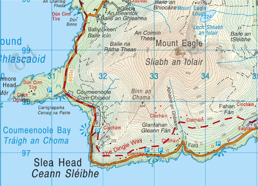
Instructions
There are ten questions in this paper.

Answer all questions.

The questions do not all carry equal marks.

Write your answers in blue or black pen. You may use pencil and colouring pencils for sketches,
graphs and diagrams only.

Write your answers in the spaces provided in this booklet. There is space for extra work at the
end of the booklet. Label any such extra work clearly with the question number and part.

This examination booklet will be scanned and your work will be presented to an examiner on
screen. Anything that you write outside of the answer areas may not be seen by the examiner.

The 1:10 000 Ordnance Survey map and legend supplied separately to this paper are for use in
questions 2 and 10.

The legend for the 1:50 000 Ordnance Survey map extracts in questions 3 and 6 is on page 30.

Junior Cycle Sample Paper                        2
Geography – Common level
Question 1

(a)   Read the article below and answer each of the following questions.

               Landslide in Indian village of Malin leaves 17 dead and 200 missing

                                                      At least 17 people were killed and 200
                                                      people were trapped as 44 houses in Malin
                                                      village were flattened by a landslide that hit
                                                      after heavy rain.

                                                      Environmentalists said large-scale
                                                      deforestation had made the place
                                                      vulnerable. An expert on landslides said “the
                                                      cause of the landslide appears to be the
                                                      clearing of land on the hill for farming and
                                                      the removal of trees”.

      (i)    In what country did this landslide take place?

      (ii)   Name one effect of the landslide mentioned in the article.

      (iii) The article states that one cause of this landslide was the “removal of trees”.
            Briefly explain how the removal of trees can lead to a landslide.

Junior Cycle Sample Paper                         3
Geography – Common level
(iv)   If this land was reforested (replanted with trees) it would help protect against future
             landslides. Describe another benefit of planting trees.

(b)   Natural disasters require immediate responses in the short-term but can also lead to longer-
      term responses.
      (i)    Other than the natural disaster named in part (a), name an example of a natural
             disaster you have studied and state where it happened.
      (ii)   Explain examples of the long-term response to the natural disaster that you studied.

 Example of natural disaster:

 Where it happened:

 Long-term responses:

Junior Cycle Sample Paper                          4
Geography – Common level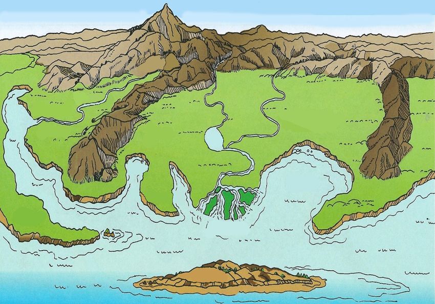
Question 2

Examine the 1:10 000 Ordnance Survey map and legend supplied separately with this paper and
answer each of the following questions.

(a)   The table below lists evidence of four functions in the town of Lusk. Use the Ordnance
      Survey map of Lusk to complete the table by answering each of the following:
      (i)    Name the function most associated with each piece of evidence.
      (ii)   State the grid square where each piece of evidence can be found on the map.
      One has been completed for you.

             (i) Function            Evidence of function            (ii) Grid square on map

             Residential           The Forge housing estate                    B3

                                   Lusk Community College

                                     St Maccullins Church

                                      Lusk Town Centre

(b)   Measure the length of Rathmore Road, in kilometres, from the Raheny Roundabout to the
      Dublin Road Roundabout.

Junior Cycle Sample Paper                        5
Geography – Common level
(c)   Complete the sketch map of Lusk below by showing and naming each of the following:
        •   The full route of Rathmore Road
        •   A post office
        •   Lusk Heritage Centre
        •   One named recreational area.

                   Sketch Map of Lusk, 2020

             N

                            Skerries Road
                                                                   Legend
                            Roundabout
                                                                   = Roundabout

                                                                   = Regional Road

                                                                   = Main Road
        Minister’s Road

                                                                   = Lusk Community Home

                     Dublin Road
                     Roundabout

Junior Cycle Sample Paper                     6
Geography – Common level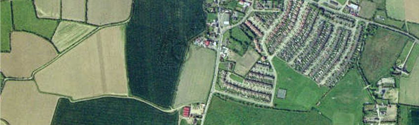
Question 3
(a) Examine the 1:50 000 Ordnance Survey map extract below of Slea Head in Co. Kerry and the
accompanying legend which is available on page 30. The road shown on the extract is a
popular tourist route.
(i) Which of the following coastal processes had the most impact on shaping the land on
the map extract above? Tick () the correct box.
Coastal deposition
Coastal erosion
(ii) What type of road is the R559?
Junior Cycle Sample Paper 7
Geography – Common level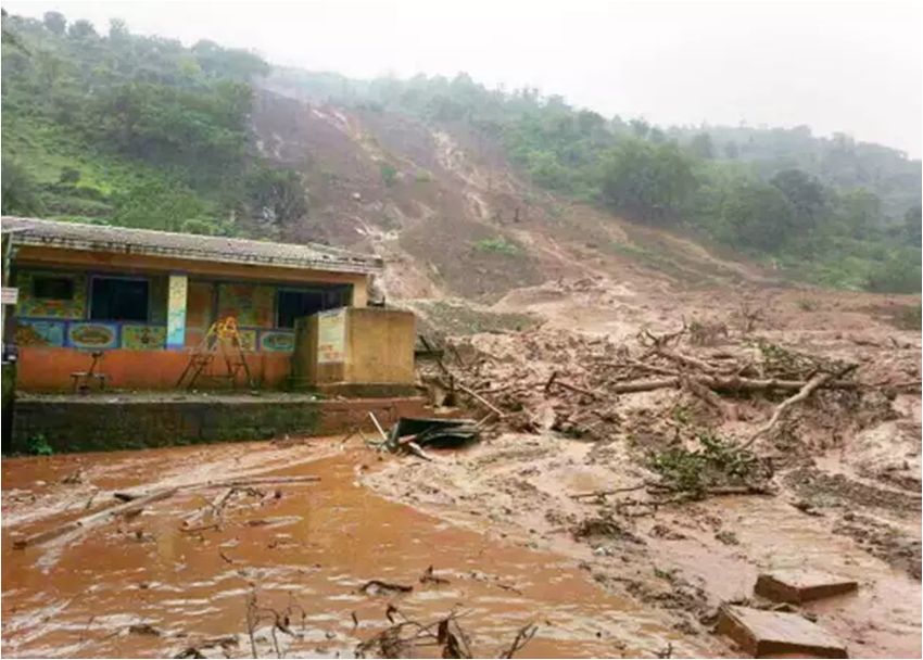
(iii) Name two different pieces of evidence from the map extract above that show how this
            area has developed to support tourism and state how each can be used by tourists.

       Evidence 1:

       How it can be used by tourists:

       Evidence 2:

       How it can be used by tourists:

(b)   The photograph below shows an area at risk of damage due to coastal erosion.

      You are concerned about the future of this area and that there may be a collapse. On the
      next page write a letter to your local councillor suggesting how the coast could be protected
      from further erosion. Your letter must include each of the following:
      (i)    An example of a coastal defence measure that would be suitable to protect the area
             from future erosion.
      (ii)   An explanation of how the coastal defence measure you named will protect the area
             from the processes of coastal erosion.
      You may also draw diagrams if you wish.

Junior Cycle Sample Paper                        8
Geography – Common level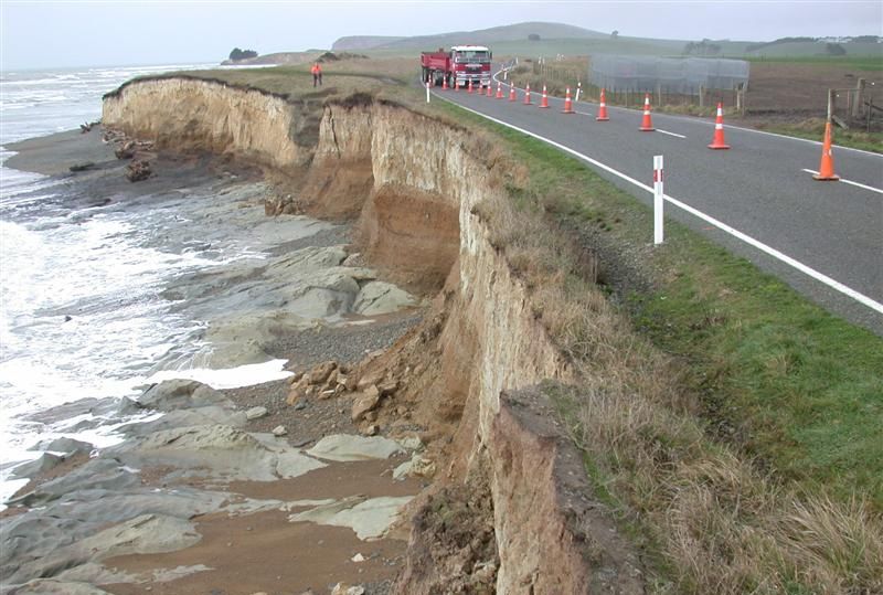
Dear Councillor,

 Space for diagrams

Junior Cycle Sample Paper   9
Geography – Common level
Question 4

Examine Figure 1 which shows a landscape that has been shaped by different physical processes
including erosion, transportation and deposition by rivers and the sea. Answer each of the
following questions.

       Figure 1
                                A

                                                           1
                   B                                                     C

                                                                     2
                                               3
                                                                              4

                                      5

(a)   In the table below, match each of the features labelled 1 to 5 on Figure 1 with the correct
      term from the box. One has been completed for you.

                            Bay               Meander                     Source

                       Headland                    Delta                 Sea stack

                       Number                           Feature

                            1

                            2

                            3

                            4                        Headland

                            5

Junior Cycle Sample Paper                          10
Geography – Common level
(b) Figure 1 shows an area along the coast similar to the area that Ireland’s first settlers arrived
at long ago. If you were one of the first settlers in the area shown in Figure 1, would you
choose to settle at site A or B or C?
Explain in detail why you would choose to settle at this site.
Chosen site:
Explanation:
Junior Cycle Sample Paper 11
Geography – Common levelQuestion 5
Each of the questions below relate to climates and how climate can affect people’s lives.
(a) Study the climate zones shown on the map below and answer each of the following
questions.
Map of the world showing climate zones
Zones
Polar/subpolar
Temperate
Subtropical
Tropical
A
(i) What is the climate zone for the area labelled A?
Tick () the correct box.
Polar/subpolar
Temperate
Subtropical
Tropical
(ii) What climate zone is Ireland in?
Tick () the correct box.
Polar/subpolar
Temperate
Subtropical
Tropical
(iii) Name one example of a climate that can be found in the Polar/subpolar zone.
Junior Cycle Sample Paper 12
Geography – Common level(b) Examine the table below showing monthly rainfall at Malin Head in the first six months of
2019 and answer each of the following questions.
Monthly rainfall at Malin Head in the first six months of 2019
Jan Feb Mar Apr May June
Rainfall
83 60 139 50 80 68
(mm)
(i) Complete the bar chart below using the information from the table for February, April
and May.
Monthly rainfall at Malin Head in the first six months of 2019
140
130
120
110
100
90
Rainfall (mm)
80
70
60
50
40
30
20
10
0
Jan Feb Mar Apr May June
(ii) How much rain fell in March 2019 at Malin Head? Use the correct unit in your answer.
(iii) In which month did the lowest amount of rain fall at Malin Head?
(iv) Calculate the mean monthly rainfall at Malin Head for the first six months of 2019.
Use the correct unit in your answer.
Optional rough work:
Answer:
Junior Cycle Sample Paper 13
Geography – Common level(c) Read the article below and answer each of the following questions.
Humanitarian Crisis in Somalia Driven by Climate Change
Somalia has a hot desert climate with high
temperatures and little rainfall. This makes any
rain that falls very important. Climate change is
leading to less rainfall in certain parts of the
world, including Somalia. Between 2016 and
2018 Somalia experienced below average
rainfall. This led to many problems for farmers
including crop failure, widespread livestock
deaths and loss of assets.
As well as farmers, the wider population of Somalia was affected as there was large scale
population displacement, hunger and malnutrition. By 2018 the number of people in
need of urgent humanitarian assistance was estimated at 4.2 million.
(i) Between what years did Somalia experience below average rainfall?
(ii) Name two effects of this below average rainfall on Somalia.
1:
2:
(iii) Study the two climate graphs below which show the monthly precipitation and
average monthly temperature for two different locations.
Which climate graph shows the monthly precipitation and average monthly
temperature for Somalia? Tick () the correct box.
Climate graph A Climate graph B
°C
Climate graph A mm °C Climate graph B
40 80 40
35
30 60
30
20 40
25
10 20 20
15
0 0
10 mm
-10
5 5
-20 0 0
J F M A M J J A S O N D J F M A M J J A S O N D
= Temperature = Precipitation
Junior Cycle Sample Paper 14
Geography – Common level(iv) The article states that 4.2 million people are in need of urgent humanitarian
assistance.
Which type of assistance do you think is most appropriate to help the people of
Somalia? Tick () the box beside your choice.
Tied aid
Emergency aid
Development aid
Justify your choice in space below.
Junior Cycle Sample Paper 15
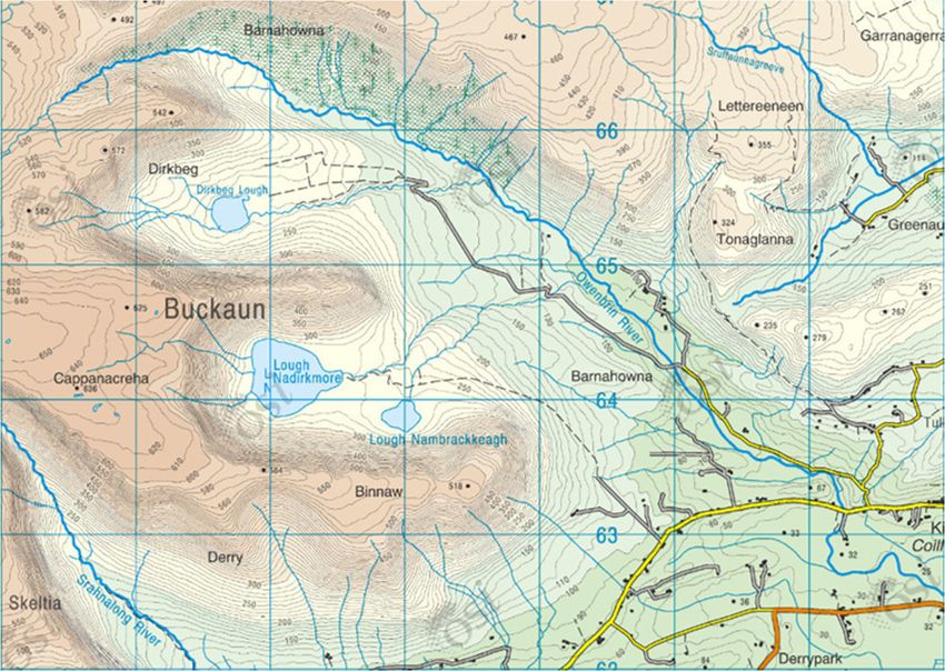
Geography – Common levelQuestion 6
Examine the 1:50 000 Ordnance Survey map extract below and the accompanying legend which is
available on page 30 and answer each of the following questions. The landscape shown on this
map extract has been shaped by different physical processes including river erosion, glacial
erosion and weathering.
98 99 00 01 02 03 04 05
67
67
N
66 66
65 A 65
64 64
B
63 63
62 62
98 99 00 01 02 03 04 05
(a) (i) At which site on the map extract above, A or B, is freeze thaw action most likely to
occur? Tick () the correct box.
A B
(ii) State one reason why freeze thaw action is most likely to occur at the site you chose.
(b) Circle the two processes of glacial erosion listed in the box below.
Plucking Solution Longshore drift
Saltation Abrasion Compression
Junior Cycle Sample Paper 16
Geography – Common level(c) On a hike through the area shown on the map extract above your friend asks you how this
landscape was formed. Write the answer you would give to explain how the processes of
glacial erosion or the processes of river erosion shaped the landscape shown on the map
extract. Refer to the map extract in your answer.
Chosen processes:
Explanation:
Junior Cycle Sample Paper 17
Geography – Common levelQuestion 7
(a) Name one example of a significant weather event that you have studied.
(b) When did this weather event happen?
(c) Name a location that was affected by this weather event.
(d) Name a weather instrument that was used to gather data during this weather event and say
what it measures.
Weather instrument:
What it measures:
(e) Explain how the weather event you named in part (a) was formed. Use at least one diagram
in your answer. There is space for diagrams on the next page.
Junior Cycle Sample Paper 18
Geography – Common levelSpace for diagram(s) (f) Why do you consider this to be a significant weather event? Junior Cycle Sample Paper 19 Geography – Common level
Question 8
(a) (i) Use the space below to draw a diagram of an active volcano.
Show and label each of the following on your diagram:
• Magma chamber
• Cone
• Vent
• Crater
• Ash cloud.
Labelled diagram
(ii) Name one example of a rock that forms when molten rock cools.
(iii) Indicate whether the following statement is true or false by ticking () the correct box.
Metamorphic rocks were once igneous or sedimentary rocks that were changed by
heat and/or pressure.
True (
False
Junior Cycle Sample Paper 20
Geography – Common level(b) Imagine you are a journalist sent to the site of a recent volcanic eruption.
Write a report describing some of the negative impacts of the volcanic eruption.
Junior Cycle Sample Paper 21
Geography – Common levelQuestion 9
Globalisation is a process that is leading to the world becoming more connected due to the
exchange of goods, people, ideas and information. Read the article below about a rural Irish town
becoming more connected to the rest of the world and answer each of the following questions.
High-speed internet puts Skibbereen at the centre of the world for connectivity
In 2016 Skibbereen became Ireland’s first one gigabit town. Before
this, Skibbereen was like many rural towns, with very low levels of
broadband internet. The access to high speed broadband has
attracted businesses to the town who can now have a global
presence.
Fifteen families have moved or relocated to Skibbereen since May
2018, attracted by the high-quality jobs as well as the quality of life.
They tell of escaping the daily commuting nightmare, lower housing costs and lower childcare
costs.
High-speed broadband is clearly having a positive effect on economic development in the town
and is contributing to a sustainable future for Skibbereen.
(a) How many families have moved or relocated to Skibbereen since May 2018?
(b) Name two pull factors mentioned in the article that attract families to live in the area.
1:
2:
(c) Imagine you are a setting up a business in Skibbereen. How will having access to high-speed
broadband be of benefit to your business?
Junior Cycle Sample Paper 22
Geography – Common level(d) Ships, like those in Figure 2 below, transport goods, people and information all over the
world.
Figure 2
A
B
(i) Which ship in Figure 2 is used by tourists to travel around the world?
Tick () the correct box.
A
B
(ii) The number of ships like the one labelled B in Figure 2 entering Irish ports has
increased.
Explain how globalisation has contributed to this increase in ships entering Irish ports.
(iii) Other than shipping, name one form of transport that connects Ireland with the rest of
the world.
Junior Cycle Sample Paper 23
Geography – Common levelQuestion 10
Between 1996 and 2016 Ireland’s population increased by more than one million people. The
questions below relate to this population growth and how it affected Ireland.
(a) The table below shows the population of Ireland in 1996 and in 2016. Study the table and
answer each of the following questions.
Year Population
1996 3,626,000
2016 4,762,000
(i) Calculate the change in population between 1996 and 2016.
Optional rough work:
Answer:
(ii) One reason for the population growth in Ireland between 1996 and 2016 was a natural
increase.
Explain what is meant by a natural increase in population.
(iii) The number of people aged 65 or older is expected to increase in the future.
Name two services that the government must invest in.
1:
2:
Junior Cycle Sample Paper 24
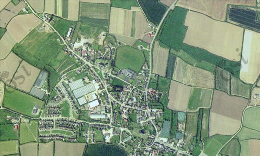
Geography – Common level(b) Lusk is one town in Ireland where the population increased between 1996 and 2016. Study
each of the following:
• The aerial photograph below showing Lusk in 2000
• The 1:10 000 Ordnance Survey map supplied separately with this paper showing Lusk
in 2019.
Lusk, 2000
A
(i) What was the area labelled A on the photograph being used for in 2000?
Tick () the correct box.
Industry
Agriculture
Quarrying
(
Junior Cycle Sample Paper 25
Geography – Common level(ii) The area labelled A on the photograph is now being used for housing estates, as can be
seen on the Ordnance Survey map of Lusk from 2019 supplied with this paper.
Explain why this area was a good location to build housing estates. Use evidence from
the aerial photograph or the Ordnance Survey map to support your answer.
(iii) Examine the aerial photograph from 2000 above and the Ordnance Survey map from
2019 accompanying this paper. Other than housing, describe one change in land-use
between 2000 and 2019.
Junior Cycle Sample Paper 26
Geography – Common level(c) In the years that Ireland’s population has been increasing, Ireland’s greenhouse gas
emissions have also increased. Study the pie chart below showing the percentage of
Ireland’s greenhouse gas emissions generated by different sectors of the economy and
answer each of the following questions.
Ireland’s Greenhouse Gas Emissions,
Percentage Share by Sector of the Economy
17
Agriculture
34 Transport
Residential
17 Waste
Energy Industries
Other
2
10
X
(i) Calculate X, the percentage share of Ireland’s greenhouse gas emissions that was
generated by transport.
Optional rough work:
Answer:
(ii) Which sector of the economy had the greatest share of greenhouse gas emissions?
(iii) Indicate whether methane is an example of a greenhouse gas by ticking () the correct
box.
True
(
False
Junior Cycle Sample Paper 27
Geography – Common level(iv) Indicate whether each of the following energy sources are renewable or
non-renewable by ticking () the correct box.
One has been completed for you.
Energy Source Renewable Non-renewable
Oil
Tidal
Peat
Biomass
(v) The Irish government has said that 550,000 new houses are needed by 2040. Builders
are considering different ways to ensure that energy use in these houses is sustainable
so that greenhouse gas emissions are as low as possible.
Name and describe one way to reduce greenhouse gas emissions from new houses.
Junior Cycle Sample Paper 28
Geography – Common levelAdditional answer space.
Label all work clearly with the question number and part.
Space for diagram(s)
Junior Cycle Sample Paper 29
Geography – Common levelJunior Cycle Sample Paper 30 Geography – Common level
Acknowledgements
Images
Image on page 3: https://timesofindia.indiatimes.com/india/8-dead-over-150-feared-trapped-after-landslide-near-
Pune/articleshow/39294619.cms (Accessed: 24/08/2020)
Image on page 7: https://maps.scoilnet.ie/OSiMaps/EsriVer17/index.html (Accessed: 24/08/2020)
Image on page 8: https://www.odt.co.nz/regions/north-otago/north-otago-erosion-could-cost-millions (Accessed:
24/08/2020)
Images on page 10: https://www.thinglink.com/scene/969025048201396227; https://pluspng.com/png-77190.html
(Both accessed: 24/08/2020)
Image on page 12: https://content.meteoblue.com/nl/meteoscool/general-climate-zones (Accessed: 24/08/2020)
Images on page 14: https://www.concern.net/where-we-work/somalia (Accessed: 24/08/2020); https://en.climate-
data.org (Accessed: 14/05/2020)
Image on page 16: https://maps.scoilnet.ie/OSiMaps/EsriVer17/index.html (Accessed: 24/08/2020)
Image on page 21: https://www.theguardian.com/us-news/2018/jun/20/hawaii-volcano-eruption-kilauea-natural-
wonders-destroyed-kapoho-bay (Accessed: 24/08/2020)
Image on page 22: https//cjgdigitalmarketing.com/the-ultimate-basics-of-online-business-promotion (Accessed:
26/08/2020)
Image on page 23: https://www.linkedin.com/company/port-of-cork-company (Accessed: 24/08/2020)
Image on page 25: http://map.geohive.ie/ (Accessed: 19/06/2020)
Image on page 27: Data in pie chart http://www.epa.ie/ghg/currentsituation/ (Accessed: 24/08/2020)
Image on page 30: Ordnance Survey Ireland
Texts
Article on page 3: Times of India, https://timesofindia.indiatimes.com/india/Landslide-in-Maharashtra-kills-17-200-
feared-trapped/articleshow/39317452.cms (Accessed: 24/08/2020)
Data on page 13: Met Éireann, https://www.met.ie/climate/available-data/monthly-data (Accessed: 24/08/2020)
Article on page 14: Concern, https://www.concern.net/where-we-work/somalia (Accessed: 24/08/2020)
Article on page 22: The Irish Examiner, https://www.irishexaminer.com/business/arid-30962947.html (Accessed:
24/08/2020)
Data on page 24: Central Statistics Office,
https://www.cso.ie/en/media/csoie/releasespublications/documents/population/2017/Chapter_1_Population_chang
e_and_historical_perspective.pdf (Accessed: 14/07/2020)

Material may have been adapted, for the purpose of assessment, without the authors’ prior consent.

Junior Cycle Sample Paper                                31
Geography – Common level
Do not write on this page

Copyright notice
This examination paper may contain text or images for which the State Examinations Commission is not the
copyright owner, and which may have been adapted, for the purpose of assessment, without the authors’ prior
consent. This examination paper has been prepared in accordance with Section 53(5) of the Copyright and
Related Rights Act, 2000. Any subsequent use for a purpose other than the intended purpose is not authorised.
The Commission does not accept liability for any infringement of third-party rights arising from unauthorised
distribution or use of this examination paper.

Junior Cycle Final Examination Sample Paper – Common Level

Geography
2 hours
You can also read