Land Records Department #13 - Real Property Lister, UAS/UAV Land Records Specialist, Surveying, Geographic Information Systems - Real Property ...
←
→
Page content transcription
If your browser does not render page correctly, please read the page content below
Land Records Department #13
                                  Real Property Lister, UAS/UAV
                                 Land Records Specialist, Surveying,
                                  Geographic Information Systems
BUDGET SUMMARY:

2022 budgeted expenditures are projected in the amount of $668,645 up 7.5% from 2021.
Revenues are projected $276,000 with a projected levy of 392,645 up 1.2%. The plat book is
planned for 2022.

The budget includes a half time address specialist, an increase of hours. Addressing fees will pay
for the position.

A few factors have impacted our office this past year and we will continue to see the increase of
the use of our department and the use of the information we provide. COVID-19, private property
sale increases, highway projects, more people moving to and building within Bayfield County.
Our records that we make available to the public and within our locale are needed for every
property sale within the county. This has put a substantial demand to our records we hold and a
need to have the most up-to-date information available to the government, public and private
entities. Almost all our data and resources have been put in a digital format and offered online. All
of the land departments rely on the information we provide to make accurate decisions. Our
funding comes from four main sources, Tax Levy, Land Sales, Sale of Maps & Services, and
Grants.

The capital budget in this section includes participation in the seven-year LIDAR flight and
derivative products. We have recently become eligible though a 3-DEP grant program to fund 75%
of the flight.

We are also asking for and increase in staff for a Rural Addressing Specialist.

FUNCTIONS:

The Land Records Department was established to perform those duties, functions, and services
defined by Wisconsin Statutes 19.967, Land Information 59.72, Land Records Modernization

Perpetuation of section corners and landmarks as defined by Wisconsin Statutes 59.74, is the
responsibility of Bayfield County in the Land Records Department. This has been the
responsibility of the county since the late 1800’s when they were originally set by the Bureau of
Land Management to split and measure property for the public use in the form of farming and
logging.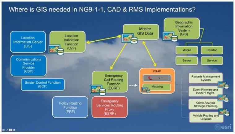
The Real Property Lister serves, as per State Statute 70.09, as the coordinator between the County
and the 28 taxation districts in Bayfield County for assessment and taxation purposes. The Property
Lister is also responsible for maintaining the tax assessment database.

Land Records Specialist is responsible for the administration of the IN-REM procedure, as per
State Statute 75.521 (the Land Records Specialist clerk assists the County Treasurer with the IN
REM process), and assists the Real Property Lister with daily duties, maintaining the GASB 34
land inventory, and ancillary tasks such as dispensing and reporting of dog licenses sold in the
County.

Most recently we have taken on the responsibilities for Rural Addressing and maintenance of
MSAG and ALI data for 911 call that come into the dispatch center. We have been doing the
mapping for the Sheriff’s department for 2009. We also are assisting with “addressing” for silent
sports using the US National Grid.

MAIN RESPONSIBILITIES:

The Land Records Department’s two guiding goals are to “Modernize Bayfield County’s Land
Records” and to “Access Land Record Data in a Timely Manner to Make Accurate Decisions”.
The task of land records modernization is accomplished by the development, implementation, and
maintenance of an enterprise Geographical Information System (GIS) that strives to provide
detailed, quality, timely, and accurate data to citizens, government agencies, and businesses in an
equitable and efficient manner. The data is important to the health, safety, and investments of the
public.

Specific goals, objectives, accomplishments, on-going activities, and future initiatives are
articulated in detail in the Bayfield County Land Records Modernization Plan that is updated
every three years. The Executive Committee serves as the oversight committee for the Land
Records Department. A Land Records Council was created to review Land Records Modernization
Funds and Policies so we could continue to retain Land Records funds. The 8-member Land
Council consists of Register of Deeds, County Treasurer, Real Property Lister or designee, County
Board member, Representative of the Land Information Office, Realtor employed within the
County, Emergency/Dispatch representative, and County Surveyor.

GIS is responsible for maintaining system infrastructure for our geospatial data and applications.
We develop plans, organize reviews, analyze, integrate, implement strategic and operational plans
to provide GIS technology applications to support the County's and department's business goals.
The GIS sector of land records oversees and provides consultation in the development of
technology solutions to achieve business goals in the areas of geographic information services.
The Sector identifies new and emerging technologies for use in County government; determine
appropriate times for pilot projects and direct implementation as necessary to test concepts, set or
modify standards and architectures, and establish plans for future implementation. We oversee and
direct the development and ongoing operation of a County Enterprise Geospatial and Open Data
Systems Architecture. Also ensure GIS and open data systems compliance with County security
standards and policies, industry backup and recovery strategies, and appropriate business
continuity planning.
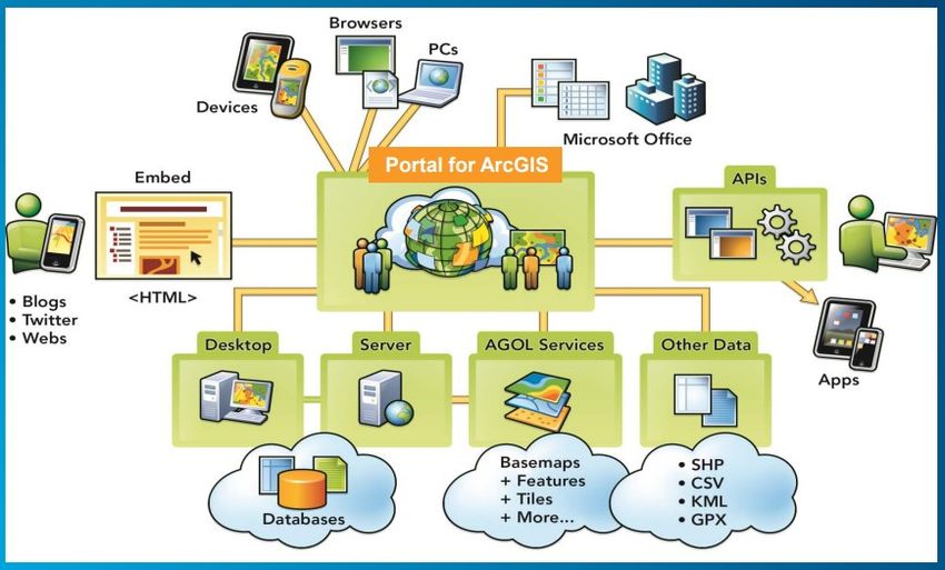
Below is a basic system infrastructure for our GIS system:

The Real Property Lister prepares and maintains accurate ownership and description information
for all parcels of real and personal property in the County for the use by taxation district assessors,
municipal clerks and treasurers, county officers, and any other persons requiring that information.
This office also provides support related to assessment and taxation for the parties mentioned
above. They also work with the WI Department of Revenue, Committee of the County Board, and
the public. Duties include data entry for the assessment rolls, notices of assessment, summary
reports, tax rolls, tax bills, and various reports and labels for over 35,000 parcels.

Land Records Specialist is responsible for indexing and returning foreclosed parcels to the tax
roll. Each year parcels delinquent for 5 years must be abstracted, published, and either have back
taxes collected or be foreclosed on. Land Records Specialist additionally assists the Real Property
Lister with recording new or altered parcels, recording database ownership changes, and assisting
taxpayers and assessors with questions regarding property ownership issues.

The County Surveyor is responsible for approving CSM’s and Subdivision Plats and survey work
done in the county to make sure it meets Bayfield County Ordinances and State Statutes. The also
review Tie Sheets to ensure proper placement of the Public Land Survey System corners. The
County Surveyor also consults the Highway, Forestry and Zoning departments on a regular basis
to provide survey related advice and field work about property boundaries.
ArcGIS Services 2020-2021
The coronavirus (COVID-19) is causing many government agencies to virtualize their GIS
environment. Government agencies that have not considered a decision to virtualize their GIS
workflow using ArcGIS Pro and ArcMap are revaluating options. Those that have experimented
with virtualizing ArcGIS Pro are expanding virtualized offering. Virtualization is the act of
creating a virtual version of a computing resource. Virtualization can move workloads from
individual PCs to a powerful server that is on premise or in the cloud. This allows multiple users
to share powerful compute resources. In this case, multiple people can use ArcGIS Pro (or
ArcMap) running in virtual machines on a server even if their own laptops are not capable of
running ArcGIS Pro (i.e., they have insufficient RAM, or they have Macs). The individual laptops
act as thin clients that interact with virtual machines running ArcGIS on the server (or in the cloud).

Bayfield County Land Records Modernization Plan 2021-2024
Every three years the Land Records department updates our Land Record Modernization Plan to
meet the State Statutes. Department of Administration will put out updated instructions in the first
half of 2021 for any new requirements for the Counties to place in the plan. Some of the updates
the Land Records department should be implementing in the plan are to create additional online
applications. The addressing and zoning applications online has made our data quality much better.
Recent use of the UAV has been beneficial to Conservation, Emergency Management, Sherriff,
and Zoning departments; expanding on this technology will be incorporated.

2020 Census
Our department will play a large role in making supervisory district maps in 2021 based on the
new population estimates.

Interactive Mapping
The flagship to the Bayfield County Land Records Department, some of the most used webpages
on the County website are our interactive mapping sites. Staff have been using project-specific
maps and will continue to create these as we have major events. Land Records Department
continued to upgrade our interactive mapping to include a 3D perspective to our maps to get an
easier to interpret oblique view. We have completed an update to the Zoning Interactive map and
will continue to make small upgrades. The interactive map for they Hydrogeologic Atlas has been
completed and we will continue to make improvements. We have moved to universal program
language (HTML5) for our interactive maps. This will also allow our users to view the application
on multiple devices and Apple products without having to install separate applications on the
desktop.

County Surveyor
Recently Bayfield County has hired a field surveyor in early March 2020. They have been doing
a great job in the last year and half working for Bayfield County. We continue to contract with
Pine Ridge Surveying to review and sign off on the field surveyor’s work. The Land Records
Department continues to contract to Lakes Area Land Surveying. Lakes Area Land Surveying
reviews Pine Ridge Surveying’s maps that are completed in Bayfield County so the County does
not have a conflict of interest.

Rural Addressing
We have taken rural addressing on from Emergency Management since March of this year. They
have continued to help though the transition and it has been very helpful to our department. Along
with Rural Addressing we have been part of a team to “address” remote silent sports areas using
the US National Grid.

FY2020-2021 ACCOMPLISHMENTS:
Land Records/GIS/Public Land Survey System
   o Completed the Domain name change and upgrades for our interactive maps that IT
      Department requested.
   o Created tentative plan for local redistricting there will be a lot of changes in district
      boundaries as to meet the 10% overall plan deviation.
   o The goals and objectives expressed in the Bayfield County Land Records Modernization
      Plan for 2016-2019.
   o Land Records Department is in the process of selling $150,000 worth of real estate the
      county acquired though the INREM process.
   o Completed aerial imagery from the UAS/Drone for the Conservation, Land Records,
      Planning & Zoning and Sherriff’s departments. Projects included search and rescue along
      with mapping pit construction, invasive species spread and flooding documentation.
   o Maintained and upgraded the Tourism interactive mapping page that includes all the
      Tourism data called EAT, PLAY, STAY.
   o Continue to add functionality to the zoning application, added new UAV imagery to the
      base maps.
   o Continued the Pictometry tool in our interactive mapping applications.
   o Completed the online addressing application form and have been getting more people
      using the application after it has been available for some time now. We are looking to
      continually include additional enhancements
      http://maps.bayfieldcounty.org/AddressApp/.
   o Made additional changes of our parcels to ESRI’s parcel fabric. Capability to see the
      change in parcels since 2003 was added. We can use ArcPro to update the parcels and will
need to continue with the training and
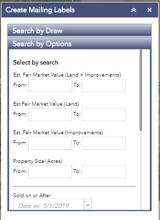
load the parcel data to our servers soon. New Mailing Label Tool Widget:
Continued to maintain functionality to
the mailing label.
o Ongoing with an addition of a Land
Surveyor we continued to grow our
repository of maps of survey, Public
Land Survey System (PLSS) records,
geodetic data, survey data, and cadastral
information.
o Ongoing initiative innovative and relied
on web program has been developed for
the Bayfield County Land Records
website that permits viewers to
interactively view these documents in a
way that a database search may not find
the results.
o Training room has most recently being
used to isolate other staff to create social
distancing for the Forestry office, we will
be starting up with training soon.
o Continued to improve NOVUS
functionality and information within the
database
o Continued, for a nominal fee as per Open
Records Law, to share 2005, 2009, 2015
aerial imagery with other agencies, as well as the general public.
o Continued maintenance of countywide road database and maps.
o Assisted supplying our maps in the new software dispatch center so we can use Next
Generation 911 calls, using our GIS data that we maintain in the dispatch center.
o Continued to cooperate with Emergency Government, Sheriff’s Department to maintain
the address, road, trail, parcel, public land and supporting data for the E-911 Dispatch
Center to ensure proper locations for wireless and land line calls.Diagram the roll of GIS in Next Generation 9-1-1.
o Maintained and updated Property Ownership Maps and assured their accessibility to all
interested parties via both traditional hardcopy maps and the web site.
o Continued monitoring of lake elevations of Pigeon Lake and sending data to Wisconsin
Geological and Natural History Survey.
o Assisted County, Towns, Cities, & Tribe with many land use, economic development, and
infrastructure improvement planning projects.
Real Property Lister/Land Records Specialist
o Completed 15th year using the NOVUS assessment and taxation program.
o The key addition to the Real Property Lister position has been adding the duty of GIS parcel
mapping and data entry. Also, entry of bearing and distance annotation into GIS.
o Every year a compilation of splits and merges, CSMs, and other important documents and
corrections are sent to the assessors. This year scanning of all files as they are completed
is being done. Files can now be sent electronically, or if the assessor still prefers to get this
mailed, there is a backup and back reference for all.
o The RPL printed all assessment roll binders this year.o More time has been spent working with title companies and attorneys correcting bad legal
Lake Water Elevations Pigeon Lake, WI
descriptions (Bayfield County does not have a deed review ordinance).
o Produce GIS customer maps
FY 2021-22 GOALS:
Land Records/GIS/Public Land Survey System
o Write updated plan for the goals and objectives expressed in the Bayfield County Land
Records Modernization Plan for 2019-2022.
o Continue to help other land departments improve workflow using GIS.
o Continue to grow our mobile mapping applications to include additional trails.
o Continue to make enhancements to the on-line addressing application, such as more
accurate parcel information and include better workflow.
o Continue to create 3D and ArcScene data online for the Sherriff and Land Related
Departments.
o Continue to work on hydrology and hydrogeology tools in ArcGIS. Pigeon Lake for
example.
o Continue to use the UAV for capturing aerial imagery.
o Invasive species monitoring, evidence preservation, tree regeneration, gravel pit
monitoring
o Maintain the addresses for the automated address locator in dispatch.
o Maintain 200-400 new splits in-house and 4,000 ownership changes a year.
o At the end of 2020 start to build Bayfield County Plat Book, looking at a much smaller
quantity printing (1000), smaller size book and less pages. Printing will begin 2021.o Continue to preserve, protect, and enhance our investment by making a concerted effort to
update, maintain, and improve property ownership maps of our county.
o Continue to make our parcel maps positionally more accurate through collecting GPS
coordinates on section corners.
o site, and other effective methods of providing citizens and policy makers with access to
meaningful and needed information.
o Continue to help with training in a virtual environment.
o Continue to provide online access to our Land Record system (NOVUS) and improve
functionality.
o Continue to check and review Certified Survey Maps (CSMs) and Plats in the Land
Records Department.
o Continue to collect PLSS corners and make them available for the public.
o Continue to “Link” our Geographic Information System by updating existing and creating
new spatial datasets to help make decisions across departments.
o Continue the process of updating our many countywide datasets by utilizing the new
orthophotography.
o Continue to innovate, to improve and hone technical skills, to work cooperatively with the
public and other governmental agencies, and to creatively leverage limited funding to
maximize resulting products and projects.
o Hold Land Resource Meetings to help the land related departments fine-tune workflow
across departments.
o Continue to fund extra help or grants in the ROD office for indexing of deeds.
Real Property/Land Records Specialist
o Added mapping parcels in a digital format.
o Continue to edit the data imported into the new tax assessment database. Establish, and
rigorously use, new standards and protocols to make listing real and personal property
consistent in the future. Combine and correct owner codes that currently exist; clean up
differences in valuation and assessment acreages.
o Continue to add volume and page numbers in the history field so the deeds can be linked
to the image for purchase.
o Continue to identify issues and “debug” the assessment database.
o Improve and add additional content to Real Property Lister web page on the Bayfield
County website. Promote the establishment of a portal to display property assessment and
taxation records.
o Continue to document changes in parcel configuration.
o Continue training/educational endeavors to promote professional growth.
o Create and update the master list of parcels owned by Bayfield County.
PERFORMANCE INDICATORS:
o Amount of people helped at the counter and online. Online services continue to grow and
are available 24 hours a day, seven days a week.
o Increased availability of access to staff by supplying a public kiosk.
o Kiosk is available to complete addressing forms also
o Number of parcels placed on the Land auction
o Number of maps printed
o Number of PLSS corners GPSed
o Degree of how current the data is maintainedo Number of requests for data
o Number of parcel splits mapped
o Addresses GPSed and mapped
o Number of roads GPSed and mapped and maintained
o Percent of exact address matches in the dispatch center from land line E-911 calls
o Survey corners recovered
o Survey maps filed
o Number of changes in the tax database/NOVUS system
o Number of new parcels in the parcel database/NOVUS system
o Amount of dollars acquired through grant funding
o Number of updates to the zoning maps
o Ability to stay informed with latest legislative issues that may impact Bayfield County
Land Records.
o Two documents which do a very good comprehensive job of highlighting past
accomplishments and future aspirations of this department can be found in the 2010-2015-
2019 Bayfield County Land Records Modernization Plan and the 2006 Bayfield County
Land Records Department Strategic Plan. We are currently in the process of updating
our Land Records Modernization Plan this year.
o These documents are available on-line at:
▪ ftp://doaftp1380.wi.gov/doadocs/WLIP/CountyLandInfoPlans/Bayfield_C
o_Land_Info_Plan_2016_Final.pdf
▪ https://www.bayfieldcounty.org/DocumentCenter/View/1040
▪ https://www.bayfieldcounty.org/DocumentCenter/View/1039LAND RECORDS DEPARTMENT
Real Property/Land Records Specialist /Surveyor/GIS/UAS
Staff Directory
Scott Galetka *
Administrator
Full Time
Claire Glafke * Pat McKuen ***
Carmen Novak * Pam Ledin *
Land Records County Surveyor
GIS Tech. I Real Property Lister
Specialist Part Time
Full Time Full Time
Full Time
Sofia Kozidis **
ROD Staff * Vacant ** Rob Turnquist*
GIS/UAS
Image Rural Addressing Surveyor
Projects
Specialist Specialist Full Time
Technician
Half Time Half Time
Full Time
*County Employee John Zmyslony*
**Contract with Premier Workforce Solutions LTE
*** Independent Contractor Part TimeYou can also read