LUCAS Soil Component: proposal for analysing new physical, chemical and biological soil parameters - JRC Publications Repository
←
→
Page content transcription
If your browser does not render page correctly, please read the page content below
LUCAS Soil Component: proposal for
   analysing new physical, chemical and
   biological soil parameters

                       Fernández-Ugalde O., Jones A., Tóth G.,
                       Orgiazzi A., Panagos P., Eiselt B.

                       2016

© European Union                                      EUR 28038 EN
LUCAS 2015
This publication is a Technical report by the Joint Research Centre (JRC), the European Commission’s science and
knowledge service. It aims to provide evidence-based scientific support to the European policy-making process.
The scientific output expressed does not imply a policy position of the European Commission. Neither the
European Commission nor any person acting on behalf of the Commission is responsible for the use which might
be made of this publication.

Contact information
Name: Oihane Fernández-Ugalde
Address: European Commission, Joint Research Centre (JRC), Directorate for Sustainable Resources, Land
          Resources Unit, Via E. Fermi 2749, I-21027 Ispra (VA), Italy
E-mail: oihane.fernandez-ugalde@jrc.ec.europa.eu
Tel.: +39 0332 783791

JRC Science Hub
https://ec.europa.eu/jrc

JRC102485

EUR 28038 EN

 PDF         ISBN 978-92-79-60683-0       ISSN 1831-9424       doi:10.2788/884940

Luxembourg: Publications Office of the European Union, 2016

© European Union, 2016

Reproduction is authorised provided the source is acknowledged.

How to cite: Fernández-Ugalde O., Jones A., Tóth G., Orgiazzi A., Panagos P., Eiselt B.; LUCAS Soil Component:
proposal for analysing new physical, chemical and biological soil parametes; EUR 28038 EN; doi:10.2788/884940

All images © European Union 2016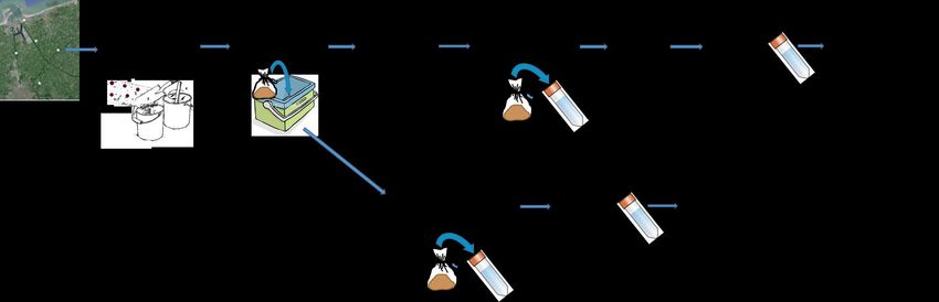
Table of contents

Acknowledgements ................................................................................................ 1
Abstract ............................................................................................................... 2
1    Introduction .................................................................................................... 3
2    Interest of broadening LUCAS Soil Component .................................................... 4
3    Sampling methods for proposed Modules ............................................................ 7
    3.1   Air-dried and field-moist samples (Modules 1 and 2) ...................................... 7
    3.2   Field measurements (Module 3) ................................................................... 8
    3.3   Undisturbed soil samples (Module 4) ............................................................ 8
    3.4   Frozen soil samples (Module 5) .................................................................... 9
    3.5   Soil profiles (Module 6) ............................................................................... 9
4    Laboratory analyses for new soil parameters ..................................................... 14
5    Impact of proposed Modules on the organization of LUCAS Soil Component .......... 15
    5.1   Surveyors’ expertise and training ............................................................... 15
    5.2   Arrangement of transport of samples .......................................................... 15
    5.3   The data management tool ........................................................................ 15
    5.4   Quality assurance of the data .................................................................... 15
    5.5   Dissemination strategy for LUCAS soil data ................................................. 16
6    Cost estimation of LUCAS Soil component ......................................................... 17
7    Conclusion: evaluation of priorities for LUCAS 2018 ........................................... 18
References ......................................................................................................... 20
List of figures...................................................................................................... 21
List of tables ....................................................................................................... 22
Annex 1: Soil properties analysed in LUCAS 2009/2012 and LUCAS 2015 ................... 23
Annex 2: Proposal for analysing new soil parameters in the LUCAS ........................... 25
Acknowledgements

Sincere thanks are due to the past and present colleagues of SOIL Team of the Land
Resources Unit in the Directorate for Sustainable Resources (DG JRC), especially
Pasquale Borrelli, Luca Montanarella, Emanuele Lugato, Marc Van Liedekerke, Ana Paya
Perez, Yusuf Yigini.
Our colleagues from DG ESTAT (Alessandra Palmieri), DG ENV (Josiane Masson and
Jacques Delsalle), DG JRC (Javier Gallego), DG AGRI (Antonio De Angelis) and EEA
(Geertrui Louwagie) also contribute to develop this proposal for LUCAS Soil Component.
Thanks are due to all of them.

                                          1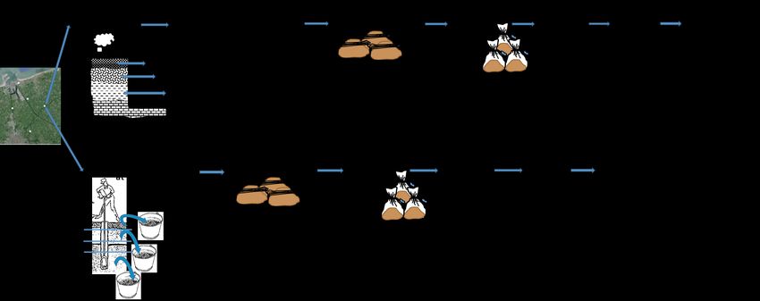
Abstract

The European Commission launched a soil assessment component to the periodic LUCAS
Land Use/Land Cover Area Frame Survey in 2009. Physical and chemical parameters in
topsoil (0-20 cm) were assessed in 23 Member States (EU-27 except Bulgaria, Romania,
Malta and Cyprus). The aim of LUCAS Soil Component was to create a harmonised and
comparable dataset of physical and chemical parameters of topsoil at the EU. The LUCAS
Topsoil Survey was extended to Bulgaria and Romania in 2012. Overall, ca. 22,000 soil
samples were collected and analysed. All samples were analysed for percentage of
coarse fragments, particle-size distribution, pH, organic carbon, carbonates,
phosphorous, total nitrogen, extractable potassium, cation exchange capacity,
multispectral properties and heavy metals. In 2015, the Topsoil Survey was repeated in
the same set of points of LUCAS 2009/2012 for monitoring changes in topsoil physical
and chemical parameters across the EU. Furthermore, the topsoil survey was extended
to Albania, Bosnia-Herzegovina, Croatia, Macedonia, Montenegro, Serbia and
Switzerland. Approximately 27,000 samples we collected in 2015 and will be analysed
over 2016 and 2017.
Currently, the European Commission is working on the organization of the upcoming
LUCAS Soil Surveys. This technical report is a proposal for analysing new physical,
chemical and biological soil parameters within the forthcoming LUCAS Soil Surveys. Soil
biodiversity is a key parameter that needs to be added to LUCAS Soil Surveys, due to
the contribution of the soil biological community to soil functions such as food and
biomass production, genetic pool for developing novel pharmaceuticals, and climate
regulation. Among physical properties, bulk density is necessary to assess soil
compaction and to estimate soil organic carbon stock in the EU. Field measurements
such as signs of soil erosion and thickness of organic layer in Histosols is also important
to assess two critical soil degradation processes in the EU: soil erosion and organic
carbon decline due to land use changes and land take of Histosols. Finally, it could be
interesting to organize a survey of soil profiles to collect information that will help to
understand soil-forming processes and to evaluate soil ability for carbon sequestration,
nutrient cycling, water storage, and contaminant filtering.

                                            2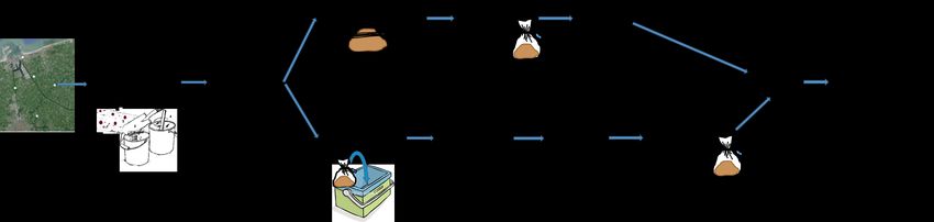
1 Introduction

Soil has a role as a habitat and gene pool, serves as a platform for human activities,
landscape and heritage and acts as a provider of raw materials. The Soil Thematic
Strategy (COM(2006)231) showed that soil degradation is a serious problem in Europe
[1]. This results in loss of soil fertility, carbon and biodiversity, lower water-retention
capacity, disruption of gas and nutrient cycles and reduced degradation of contaminants.
Soil degradation has negative impacts on natural ecosystems and climate, human
health, as well as on our economy. It is difficult to extrapolate current trends into the
future based on the limited existing data. However, the human-induced driving forces
causing soil degradation are showing an upward trend. For instance, land use/land cover
changes and climate change (in the form of global warming and extreme weather
events) are exacerbating degradation processes such as erosion and landslides, organic
carbon and biodiversity decline, compaction, and salinization. Currently, the Roadmap to
a Resource Efficient Europe (COM(2011)571) provides a long-term framework for actions
in many policy areas related to climate change, energy, raw materials, agriculture,
biodiversity and regional development [2]. In all of them soil plays a key role. At this
point, LUCAS Soil Component supplies the necessary soil data to develop future actions
towards a sustainable growth in Europe.
Since 2006, Eurostat carries out a LUCAS survey on the land use/land cover situation
and changes in the European Union [3]. The survey is conducted every three years for
around 270,000 georeferenced points extracted from a regular 2 × 2 km grid across the
EU. In 2009, a soil assessment component was added to the general LUCAS survey to
evaluate physical and chemical parameters of topsoil in the EU. The aim of the LUCAS
Soil Component was to create a harmonised and comparable dataset on topsoil at the EU
level for supporting policymaking. Approximately 20,000 points across the EU 1 were
selected from the LUCAS general survey for the LUCAS Soil Component. Selection of
points was done according to the land use/land cover heterogeneity and topography of
each country. Samples were collected from the topsoil (0-20 cm) following a
standardized sampling procedure and analysed for several physical and chemical
parameters in a central laboratory with standard methods. The same methodology was
extended to Bulgaria and Romania in 2012, where topsoil samples were collected and
analysed. See reference [4] for more details on the selection of points and the soil
sampling methodology.
The Topsoil Survey was repeated in 2015 on the same set of points of LUCAS 2009/2012
for monitoring changes in topsoil physical and chemical parameters across the EU. This
allows for controlling any variation in soil functions such as nutrient cycling, carbon
sequestration and climate regulation, water retention capacity, and soil contaminant.
Furthermore, the topsoil survey was extended to Albania, Bosnia-Herzegovina, Croatia,
Macedonia, Montenegro, Serbia and Switzerland in 2015 following the same procedure of
LUCAS 2009/2012. Overall, circa 27,000 topsoil samples were collected. The whole set
of samples will be analysed in a central laboratory with standard methods in 2016.

1
 Twenty-three Member States (EU-27 except Bulgaria, Romania, Malta and Cyprus) participated in
LUCAS Topsoil Survey 2009.

                                              3
2 Interest of broadening LUCAS Soil Component

In LUCAS 2009/2012 and 2015 Topsoil Surveys, basic physical and chemical parameters
of soil are measured. These parameters affect the ability of soil to perform its functions
and they can be used as indicators of various soil degradation processes (Annex A). For
coming LUCAS Soil Surveys, we propose to measure additional physical,
chemical and biological parameters that are also relevant to evaluate soil
functioning (Annex B): bulk density and soil moisture, electrical conductivity, organic
pollutants, contents of (NO2-NO3)-N, (SO4)-S and Na, soil biodiversity, specific
measurements for Histosols, and soil erosion. The incorporation of these soil parameters
to the current LUCAS soil analyses will improve our capacity for supporting policy-
making towards a resource efficient, low-carbon economy to achieve sustainable growth
in the EU (Roadmap to a Resource Efficient Europe, COM(2011)571).
Briefly, bulk density is a good indicator of soil compaction that can easily reduce crop
yields due to restriction of root growth, available water capacity, plant nutrient
availability, and microorganisms’ activity. It can also lead to a diminution of soil quality
due to increased runoff and degradation of soil structure. In addition, bulk density is
necessary to calculate the stock of soil organic carbon in soils. When determining bulk
density, soil moisture must also be determined to better assess hydropedological
conditions. Electrical conductivity is a good indicator of salinity and fertility problems
in soil. This is a critical problem in soils from southern EU. Analysis of organic
pollutants, together with heavy metals, will give us a full picture of the status and risk
of contamination of soils in the EU. Soil contamination can have a critical impact on the
productivity of agricultural soils. Nitrogen and sulphur are essential elements for plant
growth. However, an excessive accumulation of (NO2-NO3)-N and (SO4)-S in soil, due
to soil management practices, can result in gaseous emissions and leaching of N and S.
This can negatively affect air and water qualities. Similarly, excess of Na can cause
toxicity to plants, a breakdown of soil physical structure, and dispersion, which limits
root growth, aeration, and water infiltration through the soil. Soil biodiversity is more
and more under pressure because of the several potential threats (soil erosion, intensive
human exploitation of soil, land degradation) acting on it. It has been estimated that soil
biodiversity is under potential threats in more than half of EU-27 countries [5]. Decline
of biodiversity can negatively influence soil functioning because soil organisms support
soil functions such as food and biomass productivity, climate regulation, storage and
filtering and preservation of pharmaceutical and genetic resources. Histosols are a key
soil type for C sequestration; specifically cultivated Histosols are important because the
continued reduction of their organic layers represents a significant decline of soil organic
carbon stock. Finally, a visual assessment of soil conditions that can favour or hinder soil
erosion will provide valuable information for improving erosion risk models in Europe.
LUCAS 2009/2012 and 2015 Topsoil Surveys only include information on the 0-20 cm
depth, however characteristics of topsoil may be very different to those deeper in the
soil profile. Many soil functions cannot be explained by topsoil properties alone and
information of soil properties at various depth in the soil profile is needed to understand
them; for instance, carbon sequestration, nutrient cycling, water storage, contaminant
filtering (see Annex B). Conservation of these soil functions are crucial for developing a
European model of sustainable agriculture. Soil management should begin with
knowledge of the soil properties in the whole profile, not just in the topsoil. Thus, we
propose to establish a soil profile survey in the coming LUCAS Soil Surveys to
collect information on physico-chemical parameters at different depths and
evaluate the physico-chemical quality of soil in the EU. The addition of a soil
profile survey to LUCAS Soil Component would provide key data to support the Common
Agricultural Policy in the EU.
Table 1 shows a proposal of a work-plan for LUCAS Soil Surveys in the coming years.
According to the type of soil sample that shall be collected, soil parameters are grouped

                                             4
in six modules. Physico-chemical parameters in Module 1 shall be analysed in air-dried
samples: coarse fragments, particle-size distribution, pH, electrical conductivity, organic
carbon, carbonates, NPK, cation exchange capacity, (SO4)-S, Na, heavy metals, and
multispectral properties. All these parameters (except electrical conductivity, (SO 4)-S
and Na) have already been analysed in LUCAS 2009/2012 Topsoil Survey. They will be
analysed again, together with electrical conductivity, in soil samples collected in LUCAS
2015 Topsoil Survey. Heavy metals, (SO4)-S and Na will not be measured in samples
from LUCAS 2015 because of the cost of the analyses. Module 2 contains soil parameters
that shall be analysed in samples were soil moisture is preserved (field-moist samples):
(NO2-NO3)-N and organic pollutants. Nitrates and nitrites are primarily present in the soil
solution because they are very soluble. Thus, moisture has to be preserved in soil
samples. Organic pollutants have to be analysed in field-moist samples because this
reduces the loss of the most volatile pollutants. In Module 3, field measurements such as
soil erosion signs and thickness of organic layer in Histosols are grouped. There is no
need to collect soil samples for these parameters. We recommend monitoring soil
parameters from Modules 1, 2 and 3 every 6 years. This frequency of monitoring is
based on likelihood of soil changes due to climate and land management changes. For
instance, the interval of time needed to detect changes on soil organic carbon is of 5 to
10 years, depending on changes on vegetation, land use/land cover, and soil and
climatic conditions [6-8]. Module 4 encloses collection of undisturbed soil samples for
measuring bulk density. Soil moisture is closely related to bulk density. It can also be
measured together with bulk density in undisturbed soil samples. Bulk density varies
slowly over time, except for land use changes, thus its measuring frequency can be low
(for instance, every 20 years). Module 5 refers to frozen soil samples for assessing soil
biodiversity. Soil biodiversity is assessed by analysis of soil DNA in field-moist samples.
If analysis of DNA cannot be done closely after sampling, field-moist samples must be
frozen (at -20 ˚C) in order to avoid damages of the genetic material before analysis. For
assessing the variability over time linked to the climate and management sensitivity,
initially soil biodiversity shall be analysed every 3 years. Depending on the results, the
frequency of monitoring of soil biodiversity could be more spread afterwards. Finally,
Module 6 is for evaluation of soil profiles. Air-dried samples are required at different
depths for the evaluation of most common physico-chemical properties in soil profile
(coarse fragments, particle-size distribution, pH, electrical conductivity, organic carbon,
carbonates, NPK, cation exchange capacity, (SO4)-S, Na, and heavy metals) and
establishment of baseline values for monitoring of soil profiles. Soil profile survey shall
be done every 6 years for the monitoring of changes due to climate and land use/land
cover variations.
We propose to analyse bulk density (Module 4) and assess soil biodiversity (Module 5) in
LUCAS 2018 Soil Survey. Performing a survey of soil profiles (Module 6) is costly and
time consuming, and requires a great organization effort. Consequently, we propose to
carry out a pilot exercise to study soil profiles in a reduced number of points in 2018.
This will give us practical information to organize an extended survey of soil profiles in
the future. Furthermore, we recommend analysing critical heavy metals (i.e. those
showing great concentration in LUCAS 2009/2012 Topsoil Survey, Module 1) in 2018.
Analysis of physico-chemical parameters in Module 1 (except heavy metals) and
pollutants in Module 2, and field measurements in Module 3 shall be carried out together
in LUCAS 2021 Soil Survey because sampling methodologies for these Modules are
complementary and easy to carry out together.

                                            5
Table 1. Work-plan for LUCAS Soil Surveys in the coming years.
MODULE/ Year of survey
Soil parameters
Type of sample 2009 2010-2014 2015 2016 2017 2018 2019 2020 2021 2022 2023 2024
MODULE 1/ Coarse fragments 1 (2 mm)
Air-dried samples PSD 1 : clay, silt, sand
pH (CaCl 2 , H 2 O)
Organic C
Carbonate content
NPK
Cation exchange capacity
Electrical conductivity
(SO 4 )-S, Na
Heavy metals 2
Multisprectal properties
MODULE 2/ (NO 2 - NO 3 ) -N
Field-moist samples Organic pollutants
MODULE 3/ Thickness of peat in Histosols
Field measurements Soil erosion 3 by water / wind
MODULE 4/ Bulk density
Undisturbed samples Soil moisture
MODULE 5/ Frozen samples Soil biodiversity 4
MODULE 6/ Soil profiles5 Physico-chemical properties 6
1
Percentage of coarse fragments and particle-size distribution (PSD) in LUCAS 2015 shall be determined only
in new sampling points that were not sampled in LUCAS 2009/2012.
2
Heavy metals: As, Cd, Co, Cr, Cu, Fe, Mg, Mn, Ni, Pb, Sb, V, and Zn.
3
Depending on the variability of soil biodiversity observed between LUCAS 2018 and 2021, the frequency of
monitoring of soil biodiversity over time could be 3 or 6 years.
4
Coarse fragments, particle-size distribution, pH, electrical conductivity, organic carbon, carbonates, NPK,
cation exchange capacity, (SO4)-S, Na, and heavy metals.
This proposal has been prepared for the LUCAS Soil workshop held in Brussels on the
11th of November 2015. DGs ESTAT, ENV, AGRI, and JRC, and EEA participated in the
workshop. Priority soil information needs for supporting policy-making were established
and a work-plan for the coming LUCAS Soil Surveys was discussed. In this proposal,
we describe technical aspects of soil sampling and laboratory analyses for each
Module proposed for coming LUCAS Soil Surveys. We also present a cost
estimation of each activity in coming LUCAS Soil Surveys. Finally, the priorities
for LUCAS 2018 are presented based on the users’ needs, as discussed on the
meeting.
63 Sampling methods for proposed Modules
3.1 Air-dried and field-moist samples (Modules 1 and 2)
Soil sampling for air-dried and field-moist samples can be carried out together (Fig. 1).
At each sampling point, five sub-samples from 0-20-cm depth shall be collected and
mixed in a composite sample. Part of the composite sample (ca. 500 g) shall be air-
dried, packed in plastic bags and sent to JRC following the procedure in LUCAS
2009/2012 and 2015 Topsoil Surveys [4]. Samples shall be controlled at JRC and sent to
a central laboratory for analysis. After analyses, remaining material of air-dried samples
shall be re-sent to JRC for storing at JRC Soil Archive.
A small part of the composite sample (ca. 100 g) shall be directly packed in a plastic bag
and kept fresh in cool boxes. Field-moist samples shall be sent to JRC, where they shall
be stored at 4 ˚C in a refrigerator. Sampling and delivery of field-moist samples from
surveyors to JRC can be arranged on a weekly basis, according to characteristics of
standard cool boxes in the market 2 and transport solutions offered by shipment
companies3. Samples collected within a week can be kept fresh in cool boxes and sent to
JRC at the end of each week using an appropriate packing solution. Overall, samples
shall reach JRC within 8-9 days from sampling.
Surveyors will need the following material for sampling of air-dried and field-moist
samples: a spade, a measuring type and a bucket to collect soil samples, and plastic
bags and barcode labels to pack and identify samples at each point. In addition, for field-
moist samples, cool boxes are needed to keep samples fresh during sampling and cold
boxes are needed to transport samples at a suitable temperature. JRC shall provide a
refrigerator to store samples before sending samples to laboratory (see cost estimation
in Table 2).
We propose to carry out the sampling for air-dried and field-moist samples in the ca.
27,000 LUCAS points in LUCAS 2021 Soil Survey (Table 1), following the 6 years
monitoring frequency established for LUCAS 2009 and 2015 Topsoil Surveys. If
necessary, sampling for field-moist samples can be reduced to 50% of LUCAS points (ca.
13,500 points) in LUCAS 2021 because it will be the first time this sampling is done and
its organization requires an extra effort. Sampling can be extended to more points in
coming LUCAS surveys based on the experience gained and the results obtained in
LUCAS 2021 Soil Survey.
Due to potentially negative effects of organic pollutants on soil biodiversity, it can be
interesting to analysis organic pollutants (field-moist samples, Module 2) also in points
where soil biodiversity will be analysed in LUCAS 2018 Soil Survey (see below for
sampling method for soil biodiversity assessment (Table 1). Regarding threatening
heavy metals (i.e. those that show notably high concentrations in LUCAS 2009/2012 4),
2
For instance, Maxcold Igloo coolers are able to keep ice during 5 days
(http://www.igloo-store.com/products/fullsize/maxcoldseries).
3
Many shipment companies have specific packing solutions for cold transport of goods.
For instance, TNT offers Medpack Thermo packing solution: samples can be transported
at 2 ˚C to 8 ˚C in 72 h to 96 h
(http://www.tnt.com/content/dam/tnt_express_media/en_gb/site/services/IndustrySolutions/4374_Healthca
re_Inserts.pdf).
4
The Land Resources Unit of the Directorate for Sustainable Resources (DG JRC) is
preparing a report with the results of heavy metals from LUCAS 2009/2012.
7we recommend collecting air-dried samples in LUCAS 2018 Soil Survey. Threatening
heavy metals shall be identified and the density of sampling points shall be established
for LUCAS 2018, based on the results of the analysis of heavy metals in samples from
LUCAS 2009/2012 Topsoil Survey. This will allow us to check the repeatability and
reliability of the applied analytical method and to identify potential threats of soil
contamination in the EU.
3.2 Field measurements (Module 3)
Surveyors shall assess, based on visual field observations, soil conditions that can favour
or hinder soil erosion by water and wind (Fig. 2, Annex B). The equipment needed for
the visual assessment is simple and inexpensive: a camera to take pictures of the
sampling site, a field guide to perform the visual assessment, and a field-form to record
the visual observations (see cost estimation in Table 2). The field-form shall be prepared
by the JRC and shall contain questions such as presence and percentage of stones,
presence of plant residues in surface, signs of tillage (i.e. tillage type, direction, depth),
and signs of erosion (for instance, soil accumulation along fence-lines and drifted
appearance of the soil surface for wind erosion, and small rills and channels on the soil
surface, soil deposited at the base of slopes for water erosion).
Histosols and organic-rich soils already account for circa 5% of the sampling points in
LUCAS 2009/2012 and circa 7% of the points in LUCAS 2015 (Fig. 2, Annex B). These
soils have a key role on carbon sequestration due to their high organic carbon content.
Thus, we propose that surveyors measure the thickness of organic layer of Histosols and
organic-rich soils and record whether these soils are cultivated or not. The thickness of
organic layer is a necessary parameter to estimate the stock of organic C and it can be
an indicator of the degradation of these soils.
Field measurements are easy to perform and shall be done in the whole set of LUCAS
points (ca. 27,000 points) in LUCAS 2021 Soil Survey (Table 1).
3.3 Undisturbed soil samples (Module 4)
Undisturbed soil samples are collected in metallic rings of a known volume pressed into
soil with a mallet. At each sampling point, 3-5 undisturbed samples shall be collected
from 0-20 cm and used to calculate an average value of bulk density and soil moisture.
Once samples are collected, they have to be weighed before dried (i.e. at field water
content) and after dried. Bulk density and soil moisture can be calculated from these
data (Fig. 3). Bulk density is the weight of dry soil in a given soil volume. Soil moisture
is the mass of water compared to the mass of solid materials per unit volume of soil.
Surveyors will need the following material for collecting undisturbed soil samples: 3 to 5
numerated metallic rings with plastic caps per point, a mallet to press rings into the soil,
plastic bags, barcode labels, and a portable scale to weight samples (see cost estimation
in Table 2).
We recommend measuring bulk density in 1/3 of the LUCAS points (ca. 9,000 points) in
LUCAS 2018 Soil Survey (Table 1). Based on this data of bulk density and other physico-
chemical parameters such as particle-size distribution and organic carbon, pedotransfer
functions can be developed to predict bulk density where missing. Selected LUCAS points
for measuring bulk density shall be representative for the heterogeneity of soil texture
and organic carbon content, land use/land cover, topography and soil type within each
country. Depending on the accuracy of developed pedotransfer functions, the density of
sampling points can be extended in LUCAS 2021 (Table 1) in order to get an overview of
8soil compaction status in the EU as real and complete as possible (Annex B). The data of
bulk density and organic carbon concentration will also be used for estimating organic
carbon stock in topsoil in the EU.
3.4 Frozen soil samples (Module 5)
Soil sampling can be carried out as for air-dried and field-moist samples. Briefly, at each
sampling point, five sub-samples from 0-20-cm depth shall be collected and mixed in a
composite sample (50-100 g). Field-moist samples shall be directly packed in a plastic
bag and kept fresh (at 4 ˚C) in cool boxes until shipment to JRC. Note that field-moist
samples can be kept at 4 ˚C for max. 10 days before freezing. As for field-moist
samples, delivery of samples for soil biodiversity from surveyors to JRC can be arranged
on a weekly basis, so that samples collected within a week can be kept fresh in cool
boxes and sent to JRC using an appropriate packing solution5. At JRC, samples shall be
placed in falcon tubes and stored at -20 ˚C in a freezer. Finally, frozen samples shall be
sent to a central laboratory for analysis (Fig. 4).
Alternatively, a network of universities and laboratories that allow us using their freezers
can be created in Europe thanks to networks of EcoFINDERS project and the Global Atlas
of Soil Biodiversity. Surveyors can bring their field-moist samples to these centres,
where samples can be stored in falcon tubes at -20 ˚C in freezers. Once all samples
from a country are collected, they shall be sent to JRC for a control or directly to a
central laboratory for analysis (Fig. 4).
During the sampling, contamination of samples (from one sample to another or from
surveyors to samples) must be avoided. Thus, sampling material has to be cleaned from
one sample to another and surveyors have to use gloves. The following material is
required for the sampling: a spade, a measuring type, a bucket and gloves to collect soil
samples, plastic bags and barcode labels to pack and identify samples in the field, and
labelled falcon tubes to freeze soil samples. In addition, cool boxes are needed to keep
samples fresh during sampling and cold boxes are needed to transport samples at a
suitable temperature (see cost estimation in Table 2).
We propose to assess soil biodiversity in LUCAS 2018 Soil Survey in a selected set of
points (500-1,000 points) due to the laborious and costly organization of the sampling
(Table 1). This will be the first attempt to create a harmonized database of DNA
sequence information about soil microbial community composition in the EU. In addition,
soil biodiversity information can be linked to soil data and land use/land cover
information in the database to enhance the understanding of the impact of soil physico-
chemical conditions and characteristics of the landscape on soil biodiversity (Annex B).
3.5 Soil profiles (Module 6)
A soil profile is a historic record of all the soil forming processes and it forms the unit of
study in pedological investigation. Many soil functions cannot be explained by topsoil
properties alone, and information of soil properties at various depth in the soil profile is
needed to understand them (Annex B). The analysis of physical and chemical properties,
inspection of heavy metals and pollutants, and measurement of bulk density in topsoil
5
Many shipment companies have specific packing solutions for cold transport of goods.
For instance, TNT offers Medpack Frozen packing solution: samples can be transported
at less than -20 ˚C in 72 h to 96 h
(http://www.tnt.com/content/dam/tnt_express_media/en_gb/site/services/IndustrySolutions/4374_Healthca
re_Inserts.pdf).
9and subsoil are valuable to assess conditions that affect soil functions such as carbon
sequestration, nutrient cycling, water storage, contaminant filtering, and food and
biomass productivity throughout the soil profile.
Two sampling approaches are possible for studying soil profiles. On one hand, sampling
can be done by horizons (Fig. 5). Horizons are defined on the basis of observable
features such as texture and colour which often are directly related to important
measurable properties such as cation exchange capacity, organic carbon, nutrient status
or water holding capacity. Furthermore, the presence or absence, thickness, depth and
morphological characteristics of different soil horizons in a soil profile give important
information about soil processes that are happening or not. Preparation of a detailed soil
profile description requires the digging of a soil pit so that soil features can be observed
laterally as well as vertically. We recommend digging a pit of 60-80 cm depth.
Description and sampling of soil horizons present at the profile shall be done by an
expert soil scientist. At each soil pit, expert surveyors shall identify and describe
horizons, and take necessary samples. This approach is costly and time consuming,
because it entails costs of excavation and hiring a qualified personnel.
On the other hand, samples can be taken within fixed-depth intervals without
digging a soil pit (Fig. 5). Surveyors can take samples at least within three depth
intervals, for instance 0-20, 20-40, and 40-80 cm. Besides the material detailed in
Modules 1 and 4, surveyors will need an auger and a soil core sampler for collecting air-
dried samples and undisturbed soil samples for bulk density, respectively (see cost
estimation in Table 2). This approach is easier to apply: normal surveyors can carry it
out and organization does not require a big effort as in the soil profile sampling by
horizons. The soil profile sampling by fixed-depth intervals has advantages when
conducting studies over time and across sites for detecting changes on soil properties,
such as soil organic carbon [9]; however, it can give skew results, particularly in sites
where erosion, deposition or compaction has occurred [10,11].
Points for the soil profile survey should be selected among those that have already been
sampled in LUCAS 2009/2012 and 2015 Topsoil Surveys. The points shall be
representative, as far as possible, for the heterogeneity of land use/land cover, soil
heterogeneity and topography within each country. We can also focus the selection of
points only within agricultural soils, since a soil profile survey for forest soil in the EU
already exists (BioSoil project). It has to be noted that the selection of sampling points
for soil profile survey using LUCAS grid (regular 2 × 2 km grid across the EU) might be
problematic due to difficulties to select representative profiles as a result of the sampling
design. Therefore, as alternative, we could extend LUCAS soil survey on supplementary
sampling points, not on LUCAS grid, for the soil profile survey. Points can be selected
among representative sites proposed by soil survey organizations of the Member States
and sites of the International Network for Long-term Experiments. Soil survey
organisations and managing institutions of long-term field experiments can be involved
in the sampling and maintenance of the surveyed profiles. Sampling points should be
selected based on pedological characteristics, land use/land cover heterogeneity and
topography of each participating country.
In LUCAS 2018 Soil Survey, we propose to carry out a pilot exercise with a few number
of points, for instance 1-2 profiles per Member State, to gain experience on organizing a
soil profile survey (Table 1). In later LUCAS Soil Surveys, based on the experience
gained in LUCAS 2018, a set of approximately 2,000 representative points could be
selected from LUCAS points or from the International Network for Long-term
Experiments for studying soil profiles in the EU.
10Fig. 1. Sampling plan for air-dried (Module 1) and field-moist samples (Module 2).
Fig. 2. Field measurements in Module 3.
11Fig. 3. Sampling plan for undisturbed soil samples (Module 4).
Fig. 4. Sampling plan for frozen samples (Module 5).
12Fig. 5. Sampling plan for soil profiles (Module 6).
134 Laboratory analyses for new soil parameters
For coming LUCAS Soil Surveys, we propose to analyse additional soil parameters that
affect the ability of soil to perform its functions and can be used as indicators of various
soil degradation processes.
Electrical conductivity (Module 1, air-dried samples) can be measured in a 1:5 soil-to-
water extract (EC1:5), which it is also used to measure the pH. The EC1:5 is a variant of
the saturation paste extract method. The 1:5 soil-to-water extraction ratio generates a
large volume of solution for analysis; but this produce a great dilution of salts, much
greater than would occur in the field. Despite this drawback, for routine soil
measurements the EC1:5 is a convenient approach to assess salinity and it has the
advantage of simplicity, reduced time and low cost. The saturation-paste extraction
method reflects better the field moisture contents and it is well related to plant response
to soil salinity and leaching of soil. However, it is a tedious method and it has the
difficulty of determining the appropriate water saturation point when preparing a
saturated paste extract.
Determination of (SO4)-S and Na (Module 1, air-dried samples), and (NO2-NO3)-N
and organic pollutants (Module 1, field-moist samples) can be done following
standardized methods. (NO2-NO3)-N can be analysed by extraction with potassium
chloride solution. (SO4)-S can be analysed in water and acid extracts of soil by a
gravimetric method in which barium chloride is use to precipitate sulphate.
Determination of Na can be done together with heavy metals using techniques such as
inductively coupled plasma mass spectrometry (ICP-MS) and X-ray fluorescence. These
analyses will entail additional laboratory costs.
Soil biodiversity (Module 2, frozen samples) can be assessed by means of DNA tools
(also known as metabarcoding approach, [13]). This methodology consists of the
extraction of DNA from soil for the identification of the main groups of soil organisms:
bacteria, protists, fungi, nematodes, insects and earthworms. The DNA analysis will
allow to (i) get an overview of the species present in each soil sample, and (ii) to have
an approximate idea of the relative abundance of the considered soil organisms. Field-
moist samples are needed for soil DNA analysis. Since samples cannot be analysed
immediately after sampling, they have to be frozen to avoid damages of genetic
material. In addition to the specific conditions of storage, DNA analysis requires a great
laboratory work. Consequently, we propose to conduct DNA analysis in a reduced
number of samples, for instance around 1,000 soil samples. Soil biodiversity has to be
assessed during the Spring-Summer active period for most soil organisms, in particular
meso- and micro-fauna, to obtain an accurate community structure of the soil
biodiversity.
145 Impact of proposed Modules on the organization of LUCAS
Soil Component
Module 1 contains physico-chemical parameters already analysed in LUCAS 2009/2012
and 2015 Topsoil Surveys. The sampling method in Module 1 follows the procedure in
LUCAS 2009/2012 and 2015 [4], thus its performance has no implications on the
organizational aspects of coming LUCAS Soil Surveys. However, analysis and
measurement of soil parameters in Modules 2, 3, 4, 5, and 6 require to carry out new
sampling methods in LUCAS Soil Surveys (see section 3). Consequently, the organization
of coming LUCAS Soil Surveys has to be adapted to take on these Modules. Below we
detail some of the organizational aspects that have to be readjusted.
5.1 Surveyors’ expertise and training
Normal surveyors can conduct soil sampling for all Modules following an appropriate
training. If the horizon approach is used for studying soil profiles (Module 6), it is
mandatory to hire expert surveyors, for instance soil scientists.
5.2 Arrangement of transport of samples
Transport of samples to JRC and/or a central laboratory for analysis have to be
readjusted for field-moist samples in Module 2 and frozen samples in Module 5. The
transport of these samples requires special conditions of temperature. Field-moist
samples in Module 2 have to be transported at maximum 4 ˚C to ensure that their
humidity is preserved. Frozen samples in Module 5 shall be transported at -20 ˚C to
maintain the cold chain and avoid damages of biological material of samples. Specific
cold boxes and refrigerator trucks will be needed for the transportation of these samples,
as described in the above sections.
5.3 The data management tool
The existing schema of data management tool (DMT) can be used for coming LUCAS Soil
Surveys. Analysis of additional soil parameters in LUCAS Soil Surveys will not have big
implications on the DMT. For the soil profile survey, the schema of the existing DMT shall
be adapted to deal with horizons or fixed-depth layers within soil profiles.
5.4 Quality assurance of the data
Following the LUCAS 2009/2012 and 2015 Topsoil Surveys, we recommend applying a
uniform sampling design, standardized methodologies and nomenclature to secure the
internal coherence of the data. The surveyors shall follow precisely described quality
procedures during field measurements and collection of samples. Furthermore, samples
shall be analysed in an accredited central laboratory using standard methods to provide
coherent and comparable data.
15If necessary, quality controls of laboratory analyses and data storage can be conducted
according to the procedures established in the LUCAS 2009/2012 Topsoil Survey [4]. For
instance, internal control and external peer review process of the DMT, control of
laboratory analyses by repeated analyses of randomly selected samples and control of
registration of samples, and assessment of data against pedological criteria by soil
experts.
5.5 Dissemination strategy for LUCAS soil data
The analytical data of the Soil Profile Survey in 2018 will be available for the public
through the European Soil Data Centre. The data from LUCAS 2009/2012 Topsoil Survey
is already available in the European Soil Data Centre. For LUCAS 2015 Topsoil Survey,
the analyses are in progress and the data will be available in the future.
The samples of all LUCAS Soil Surveys will be stored in the JRC’s European Soil
Repository for future research purposes. Currently, the repository contains soil samples
from LUCAS 2009/2012 Topsoil Survey.
166 Cost estimation of LUCAS Soil component
Table 2. Cost estimation of each Module proposed in this proposal, based on data from LUCAS 2015 Soil Survey and market research.
Cost per hour
transport (€)
surveyor (€)
Total cost of
point (min)
Recurrence
Number of
Surveyors'
surveyors
Time per
of points
Number
per day
(years)
profile
Points
Special Total cost of analysis
Module Equipement Unit cost of equipement (€) Training needs
needs (€)
Module 1: Air-dried samples
Spade, measuring tape, bucket 80
Sampling 6 ca. 27,000 normal 700 normal 10 10 n.a. n.a. n.a. 3 h (2 theory + 1 practice)
Plastic bags 4,390 (cost for 27,000 samples)
Transport of samples 6 ca. 27,000 n.a. n.a. n.a. n.a. n.a. n.a. n.a. n.a. 15,000 n.a. n.a.
Analysis (all except heavy metals) 700,000
6 ca. 27,000 n.a. n.a. n.a. n.a. n.a. n.a. n.a. n.a. n.a. n.a.
Analysis of heavy metals 1,000,000
Storage of samples at JRC Soil Archive n.a. ca. 27,000 n.a. n.a. n.a. n.a. n.a. n.a. n.a. n.a. n.a. n.a. n.a.
Module 2: Field-moist samples
Spade, measuring tape, bucket Equipment for air-dried samples is used
No additional training
Sampling 6 ca. 27,000 normal 700 normal 5 10 cooling Plastic bags 4,390 (cost for 27,000 samples) n.a. n.a.
needed
Cool boxes, reusable cool packs 300
Transport of samples at 4 ˚C 6 ca. 27,000 n.a. n.a. n.a. n.a. n.a. cooling Positive cold boxes 583 15,000 n.a. n.a.
Storage of samples at 4 ˚C, before
6 ca. 27,000 n.a. n.a. n.a. n.a. n.a. cooling Refrigerator 10,474 n.a. n.a. n.a.
sending samples to laboratory
Analysis 6 ca. 27,000 n.a. n.a. n.a. n.a. n.a. n.a. n.a. n.a. n.a. n.d. n.a.
Module 3: Field measurements
Thickness of peat in Histosols 6 ca. 2,000 normal 700 normal 3 10 n.a. Spade, measuring tape Equipment for air-dried samples is used n.a. n.a.
20-30 min. theory
Evaluation of soil erosion 6 ca. 27,000 normal 700 normal 5 10 n.a. Camera 100 n.a. n.a.
Module 4: Undisturbed samples
Metallic ring 17
Sampling n.a. ca. 9,000 normal 200 normal 15 6 n.a. Mallet 15 n.a. n.a.
10 min. practice
Plastic bags 4390
Weighing n.a. ca. 9,000 normal 200 normal n.a. n.a. n.a. Scale 80-300 n.a. n.a.
Module 5: Frozen samples
Spade, measuring tape, bucket 80
2 per Plastic bags 150
Sampling 3 500-1,000 normal normal 10 4 cooling n.a. n.a. 3 h (2 theory + 1 practice)
country Gloves 274
Cool boxes, reusable cool packs 300
cooling Positive cold boxes (surveyors to JRC) 58
Transport of samples 3 500-1,000 n.a. n.a. n.a. n.a. n.a. 75,000 n.a. n.a.
freezing Negative cold boxes (JRC to laboratory) 44
Storage of samples at -20 ˚C at JRC, Ultra Low Freezer 10,000-15,000
3 500-1,000 n.a. n.a. n.a. n.a. n.a. freezing n.a. n.a. n.a.
before sending samples to laboratory Falcon tubes 26
Analysis 3 500-1,000 n.a. n.a. n.a. n.a. n.a. n.a. n.a. n.a. n.a. 90 n.a.
Module 6: Soil profiles
Spade, measuring tape, bucket 80
normal/ 5 per normal/ Plastic bags 1,500
Sampling 6 ca. 2,000 20/45 5/2 n.a. n.a. n.a. 2 h (1 theory + 1 practice)
expert country n.d. Auger 70
Soil core sampler, metallic rings 2,000
Transport of samples 6 ca. 2,000 n.a. n.a. n.a. n.a. n.a. n.a. n.a. n.a. 15,000 n.a. n.a.
Analysis 6 ca. 2,000 n.a. n.a. n.a. n.a. n.a. n.a. n.a. n.a. n.a. 700,000 n.a.
Storage of samples at JRC Soil Archive n.a. ca. 2,000 n.a. n.a. n.a. n.a. n.a. n.a. n.a. n.a. n.a. n.a. n.a.
177 Conclusion: evaluation of priorities for LUCAS 2018
Based on the users’ needs collected, the following priorities have been set for LUCAS
2018 Soil Component:
Assessing soil biodiversity is critical due to its influence on soil quality. Soil organisms
support soil functions such as food and biomass productivity, climate regulation,
transport and storage of substances, and preservation of pharmaceutical and genetic
resources. Thus, a decline of soil biodiversity can negatively influence soil functioning
and quality. However, currently there is no detailed survey of soil biodiversity in the EU.
EcoFINDERS project (ended in December 2014) is the most recent project assessing soil
biodiversity in the EU soil, with about 80 points of control [14]. We propose to launch a
soil biodiversity survey with 1,000 points of control in LUCAS 2018 Soil Survey. This will
allow assessing the status of biodiversity regarding land use/land cover and physico-
chemical properties of soil in the EU. This information will help the European Commission
to develop and implement strategies for a sustainable use of the soils. Such an
assessment will be of key relevance to the achievement of the EU2020 Biodiversity
Strategy.
Measuring bulk density is also a top priority for assessing soil compaction and
estimating organic carbon stock. Soil compaction negatively affects soil functions such as
food and biomass production, storage and transport of water and habitat and gene pool.
Since it is inversely related to porosity, bulk density is a key indicator of soil compaction
(i.e. soil compaction increases bulk density as decreases porosity). Bulk density is also
necessary to calculate organic carbon stock in soil, which is key data for developing
future actions towards a sustainable growth in the EU and it will be very useful
information for supporting the Roadmap to a Resource Efficient Europe (COM(2011)571).
We propose to measure bulk density at least in 1/3 of the points in LUCAS 2018 Soil
Survey in order to assess soil compaction and carry out estimations of soil organic
carbon stocks. Since soil compaction can negatively affect soil biodiversity, we
recommend including the points where soil biodiversity will be assessed on the set of 1/3
points for bulk density.
Heavy metals have only been analysed in soil samples collected in LUCAS 2009/2012
Topsoil Survey. Based on this data, the Land Resource Management Unit of JRC is
currently preparing a report of results of heavy metals in topsoil in the EU. The goal of
the report is to show regional and land use/land cover specific trends on the distribution
of heavy metals and to identify potential threats of soil contamination by heavy metals in
topsoil in the EU. This report will allow us to identify critical heavy metals that shall be
analysed in coming LUCAS Soil Surveys. We recommend repeating soil sampling to
analyse critical heavy metals in LUCAS 2018, in order to check the repeatability and
reliability of the applied analytical method. Density of sampling points for this purpose
can be adapted, i.e. focused in specific regions of the EU and specific land uses/land
covers, based on the results of heavy metals in LUCAS 2009/2012 Topsoil Survey.
For EU policies on agriculture, climate and environment, 2018 is an important reference
year. As a result, there is an increasing demand for up-to-date information on soils for
2018. This information will be used to support EU policies in the following years. Thus, a
topsoil sampling will have to be included in the LUCAS 2018 Survey in order to
analyse physical and chemical parameters already examined in the LUCAS
2009/2012 and the LUCAS 2015. Field measurements such as signs of soil
erosion and thickness of organic layer in Histosols will be also analysed in LUCAS
2018 to assess two critical soil degradation processes in the EU: soil erosion and organic
carbon decline due to land use changes and land take of Histosols.
Studying soil profiles provides extremely rich information on the soil system for
environmental and agricultural applications. Thus, a soil profile survey is important for
implementing a sustainable soil management plan in the EU. However, organizing such a
18survey has several difficulties as explained before: selection of representative (land
use/land cover and soil heterogeneity) sampling points using LUCAS grid might be
problematic, and expert surveyors might be also needed for the profile description.
Consequently, a survey of soil profiles might be costly and time-consuming. We consider
that a survey of soil profiles is not feasible with the available budget and technical
resources for the LUCAS 2018. The capacity of performing a soil profile survey within
LUCAS Soil Component might be studied for coming LUCAS Surveys.
19References
[1] European Commission, 2006, The Soil Thematic Strategy. Available online:
http://eur-lex.europa.eu/legal-content/EN/TXT/?uri=CELEX:52006DC0231
[2] European Commission, 2011, The Roadmap to a Resource Efficient Europe. Available
online:
http://ec.europa.eu/environment/resource_efficiency/about/roadmap/index_en.htm
[3] European Commission, LUCAS – Land use and land cover survey. Available online:
http://ec.europa.eu/eurostat/statistics-explained/index.php/LUCAS_-
_Land_use_and_land_cover_survey
[4] Tóth G., Jones A., Montanarella L., 2013. LUCAS Topsoil Survey. Methodology, data
and results. EUR – JRC Technical Reports; EUR 26102 EN; doi:10.2788/97922.
[5] Orgiazzi A., Panagos P., Yigini Y., Dunbar M.B., Gardi C., Montanarella L., Ballabio C.,
2016. A knowledge-based approach to estimating the magnitude and spatial patterns of
potential threats to soil biodiversity. Science of The Total Environment 545–546, 11–20.
[6] Post W.M., Izaurralde R.C., Mann L.K., Bliss N., 2001. Monitoring and verifying
changes of organic carbon in soil. Climatic Change 51, 73–99.
[7] Smith P., 2004. How long before a change in soil organic carbon can be detected?
Global Change Biology 10, 1878–1883.
[8] Mäkipää R., Häkkinen M., Muukkonen P., Peltoniemi M., 2008. The costs of
monitoring changes in forest soil carbon stocks. Boreal Environment Research 13, 120–
130.
[9] Grüneberg E., Schöning I., Kalko E.K.V., Weisser W.W., 2010. Regional organic
carbon stock variability: A comparison between depth increments and soil horizons.
Geoderma 155, 426–433.
[10] Davidson E.A., Ackerman I.L., 1993. Changes in soil carbon inventories following
cultivation of previously untilled soils. Biogeochemistry 20, 161-193.
[11] Robertson G.P., Coleman D.C., Bledsoe C.S., Sollins P., 1999. Standard Soil
Methods for Long-Term Ecological Research. Oxford University Press, Inc.
[12] European Commission, 2010, BioSoil. Available online:
http://ec.europa.eu/environment/forests/pdf/biosoil_brochure2010.pdf
[13] Orgiazzi A., Dunbar M.B., Panagos P., de Groot G.A., Lemanceau P., 2015. Soil
biodiversity and DNA barcodes: opportunities and challenges. Soil Biology and
Biochemistry 80, 244–250.
[14] EcoFINDERS, FP7 project reference in CORDIS:
http://cordis.europa.eu/result/rcn/54810_en.html
20List of figures
Fig. 1. Sampling plan for air-dried (Module 1) and field-moist samples (Module 2).
Fig. 2. Field measurements in Module 3.
Fig. 3. Sampling plan for undisturbed soil samples (Module 4).
Fig. 4. Sampling plan for frozen samples (Module 5).
Fig. 5. Sampling plan for soil profiles (Module 6).
21List of tables
Table 1. Work-plan for LUCAS Soil Surveys in the coming years.
Table 2. Cost estimation of each Module proposed in this proposal, based on data from
LUCAS 2015 Soil Survey and market research.
22Annex 1: Soil properties analysed in LUCAS 2009/2012 and LUCAS 2015
Soil information
Related soil functions Related soil degradation processes Related legislations
/Potentially interested DGs, Agencies
Organic carbon Food and other biomass production Organic C and other nutrients decline Agricultural Policies
/ AGRI, ENV, CLIMA, JRC, EEA Storage, filtration, transformation Biodiversity decline Common Agricultural Policy
- ca rbon s eques tra tion Erosion Nitrates Directive
- nutri ent cycl i ng Sustainable Pesticide Use Directive
- wa ter s tora ge, fi l tra ti on Use of Sewage in Agriculture
Climate regulation Environmental and Climate Policies
Other soil properties related to OC: Environmental Impact Assessment Directive
- Buffering ability Water Framework Directive
- Hydraulic conductivity Floods Directive
Coarse fragments, Storage, filtration, transformation Erosion Air Quality Framework Directive
Clay, silt, and sand - wa ter s tora ge, fi l tra tion Landslides Habitat Directive
/ AGRI, ENV, JRC - fi l teri ng: conta mi na nts , exces s nutri ents Compaction LULUCF Decision
- nutri ent cycl i ng Contamination EU Strategy on Adaptation to Climate Change
- ca rbon s eques tra ti on Industrial Policies
Food and other biomass production Landfill of Waste Directive
Source of raw material Waste Framework Directive
Habitat and gene pool Others
pH Storage, filtration, transformation Salinization Roadmap to a Resource Efficient Europe
/ AGRI, ENV, JRC - nutri ent cycl i ng Contamination EU2020 Biodiversity Strategy
- fi l teri ng: conta mi na nts , exces s nutri ents Other problems : Nutrient imbalance Horizon 2020: Research and Innovation
Cation exchange capacity Storage, filtration, transformation Other problems : Nutrient imbalance 7th Environmental Action Programme
/ AGRI, ENV, JRC - nutri ent cycl i ng
- fi l teri ng: conta mi na nts , exces s nutri ents
Other soil properties related to CEC:
- Buffering ability
NPK Food and other biomass production Other problems: Nutrient depletion
/ AGRI, ENV, JRC, EEA Nutrient imbalance
Electrical conductivity Storage, filtration, transformation Salinization
/ AGRI, ENV, JRC - nutri ent cycl i ng Contamination
- fi l teri ng: conta mi na nts , exces s nutri ents Other problems: Nutrient imbalance
23Annex 1 (continuation)
Soil information
Related soil functions Related soil degradation processes Related legislations
/Potentially interested DGs, Agencies
Calcium carbonate Lithogenic and/or secondary carbonates are important components of the mineral Agricultural Policies
/ AGRI, ENV, JRC fraction in many semi-arid and arid soils, such as Calcisols. Calcium carbonate is: Common Agricultural Policy
▪ key agent of cementation (affects formation of stable aggregates) Sustainable Pesticide Use Directive
▪ part of the C cyle (formation of pedogenic carbonates can result in the incorporation of Use of Sewage in Agriculture
C of biological origin into the soil mineral fraction, participating in the long-term C Environmental and Climate Policies
sequestration) Environmental Impact Assessment Directive
▪ regulating soil pH Water Framework Directive
Habitat Directive
LULUCF Decision
Heavy metals —— Contamination
Industrial Policies
/ AGRI, ENV, SANTE, REGIO, JRC, EEA
Landfill of Waste Directive
Waste Framework Directive
Others
Roadmap to a Resource Efficient Europe
EU2020 Biodiversity Strategy
Horizon 2020: Research and Innovation
7th Environmental Action Programme
Multispectral properties The near-infrared reflectance spectroscopy (NIRS) is a rapid, non-destructive, reproducible and cost-effective analytical technique for
/ AGRI, ENV, CLIMA, JRC, EEA characterization and quantification of properties of materials.
The NIRS can be a good tool of assessment and monitoring of soil quality. Its potential use has been widely recognized for soil science.
Indeed, it has been use to predict chemical, physical and biological properties of soil (such as C and N content, CEC and clay content).
However, these studies are limited to a small number of samples analysed, lack of diversity of soil types and/or a small number of soil
properties tested. The LUCAS Soil Survey provides the opportunity to apply this technology in a wide variety of soil types and conditions
to (i) validate the ability of the NIRS to measure a wide variety of soil properties, and (ii) collect a large amount of NIRS soil data across
EU required for monitoring and assessing soil quality.
24You can also read


