Material and social relations in a coastal community garden assemblage
←
→
Page content transcription
If your browser does not render page correctly, please read the page content below
SOCIAL & CULTURAL GEOGRAPHY
https://doi.org/10.1080/14649365.2019.1658800

Material and social relations in a coastal community garden
assemblage
                                   a
Lindsay K. Campbell                    , Erika S. Svendsena, Renae Reynoldsb and Victoria Marshallc
a
 USDA Forest Service, New York City Urban Field Station, New York, USA; bNew York City Urban Field
Station, New York, USA; cTill Design, Newark, USA

    ABSTRACT                                                                              ARTICLE HISTORY
    This paper draws upon Actor Network Theory (ANT) to explore                           Received 8 January 2018
    material and social dynamics of a coastal community garden site on                    Accepted 10 July 2019
    public housing grounds in Rockaway, NY after Hurricane Sandy.                         KEYWORDS
    Through a participatory design-research project, we examine shifting                  Actor network theory;
    associations between humans and non-humans as a way of inter-                         contact zone; design;
    rogating agency, power dynamics, and governance. Acknowledging                        participatory research;
    our own outsider status, we draw upon the frame of ‘contact zones’                    power; stewardship
    for thinking through encounters in conditions of power differentials.
                                                                                          PALABRAS CLAVE
    In describing our encounter with the Beach 41st Street Community
                                                                                          teoría del actor – red; zona
    Garden as a contact zone, we identify three assemblages with differ-                   de contacto;
    ent governance arrangements – tidal shore, garden plots, and treed                    diseñoinvestigación
    lawn. These assemblages are networked through material flows and                       participativa; poder;
    include nonhuman actants such as freshwater, soil, plants, and wood.                  administración
    Unruly actors and actants – people, saltwater, poison ivy, dogs, and
    trash – can spark controversy and resist governing. We reflect upon                    MOTS-CLEFS
                                                                                          théorie de l’acteur-réseau;
    the role of design, research, and community organizing as interven-
                                                                                          zone de contact; conception;
    tions that can cause rearrangements of the assemblages, shedding                      recherche participative;
    new light on power dynamics and potential apertures for change in                     pouvoir; gérance
    a dynamic site. In so doing, we mobilize contact zones and ANT to
    better understand and act within shifting associations between
    humans and non-humans.

    Relaciones sociales y materiales en el ensamblaje
    de un jardín comunitario costero
    RESUMEN
    Este artículo se basa en la teoría del actor-red (ANT, por sus siglas
    en inglés) para explorar la dinámica material y social de un jardín
    comunitario costero en el terreno de viviendas públicas en
    Rockaway, Nueva York, después del huracán Sandy. Mediante un
    proyecto de investigación-acción participativa, examinamos las
    asociaciones cambiantes entre humanos y no humanos como
    una forma de interrogar la agencia, las dinámicas de poder y la
    gobernanza. Reconociendo nuestro propio estatus como agentes

CONTACT Lindsay K. Campbell           lindsay.campbell@usda.gov     USDA Forest Service, New York City Urban Field
Station, New York, USA
Renae Reynolds’ current affiliation is the New York City Environmental Justice Alliance, New York, NY.Victoria Marshall’s
current affiliation is the National University of Singapore, Department of Geography and ETH Future Cities Lab,
Singapore.
© 2019 Informa UK Limited, trading as Taylor & Francis Group
2 L. K. CAMPBELL ET AL.
externos, recurrimos al marco de ‘zonas de contacto’ para pensar
a través de encuentros en condiciones diferenciales de poder. Al
describir nuestro encuentro con el Jardín Comunitario de Beach
41st Street como una zona de contacto, identificamos tres ensam-
blajes con diferentes acuerdos de gobierno: la orilla, las parcelas
de jardines y el césped arbolado. Estos ensamblajes están conec-
tados en red a través de flujos de materiales e incluyen agentes no
humanos como el agua dulce, el suelo, las plantas y la madera. Los
actores indisciplinados y los actantes (gente, agua salada, hiedra
venenosa, perros y basura) pueden provocar controversia
y resistirse al gobierno. Reflexionamos sobre el papel del diseño,
la investigación y la organización de la comunidad como interven-
ciones que pueden causar reordenamientos de estos ensamblajes,
arrojando nueva luz sobre la dinámica de poder y posibles aper-
turas para el cambio en un sitio dinámico. Al hacerlo, empleamos
las zonas de contacto y ANT para comprender mejor y actuar
dentro de asociaciones cambiantes entre humanos y no humanos.
Les relations matérielles et sociales dans un jardin
communautaire littoral en tant qu’assemblage
RÉSUMÉ
Cet article puise dans la théorie de l’acteur-réseau pour explorer les
dynamiques matérielles et sociales d’un jardin communautaire litto-
ral situé sur un terrain de logements sociaux dans la péninsule de
Rockaway, à New York, après l’ouragan Sandy. À partir d’un projet
participatif de conception-recherche, nous examinons les associa-
tions changeantes entre les humains et non-humains afin d’interro-
ger actions, dynamiques de pouvoirs et gouvernance. Reconnaissant
notre propre statut d’étranger, nous empruntons le concept de «
zones de contact » afin de penser les rencontres à travers les
déséquilibres de pouvoir. En décrivant notre rencontre avec le jardin
communautaire Beach 41st Street comme une zone de contact, nous
identifions trois assemblages aux modalités de gouvernance diver-
ses – rivage à marée, parcelles de jardin et pelouses boisées. Ces
assemblages sont organisés en réseau par des flux matériels qui
contiennent aussi des non-humains tels que de l’eau douce, de la
terre, des plantes et du bois. Des acteurs et actants indisciplinés –
individus, eau de mer, sumac grimpant, chiens et déchets – peuvent
créer des controverses et résister au pouvoir. Nous réfléchissons au
rôle de la conception, de la recherche et du community organising
comme interventions qui provoquent le réarrangement de ces
assemblages, éclairant ainsi d’une lumière nouvelle les dynamiques
de pouvoir et les possibilités de changement dans un site dyna-
mique. Ce faisant, nous mobilisons les zones de contact et la
théorie de l’acteur-réseau pour mieux agir et mieux comprendre les
associations changeantes entre les humains et non-humains.
Introduction
This paper draws upon Actor Network Theory (ANT) as an assemblage approach that reworks
our understanding of human and non-human relations to explore the material and social
dynamics of a coastal community garden site after a storm (Latour, 2005; Power, 2005). TheseSOCIAL & CULTURAL GEOGRAPHY 3 material and social dynamics can be considered power dynamics from an ANT perspective. As Stone-Jovicich (2015, p. 25) summarizes, ‘actor-network theory looks at power from a different angle: how it emerges as a result of processes of networking among human and nonhuman actors. Rather than looking at capitalist structures and knowledge systems as ways to explain power, social injustices and inequities, and environmental degradation, ANT investigates how these structures and systems “come into being.”’ In other words, for ANT, power is the phenomenon to be explained, rather than the explanation (Alcadipani & Hassard, 2010). Thus, we examine the everyday and shifting associations between people and things as a way of interrogating the agency, power, and governance of the site. ANT provides a framework for describing how this dynamic system came together and continues to be reassembled around a changing set of concerns, including coastal flooding, community stewardship, public safety, and maintenance. As part of a coupled, participatory research- design project from 2013–2017, we worked with the residents of the Beach 41st Street Community Garden (B41 Garden), a coastal community garden on public housing grounds on the Rockaway Peninsula in Queens, NY that was heavily impacted by Hurricane Sandy. The case study focuses on a period of major reorganization of the use of space and changes in material flows throughout the network; providing an opportunity to understand both dyna- mism – the ways in which assemblages are rearranged – and obduracy – the things that are resistant to change within the system (Gunderson & Holling, 2002; Hommels, 2005). Recognizing our own status as outsiders engaged with a historically marginalized com- munity, we draw upon the notion of the ‘contact zone’ (Pratt, 1992) – as filled with encounters of both friction and exchange between actors (and actants) with differential access to power and resources. While ANT’s flat ontology has been critiqued for not dealing well with structural power and social inequality (Rudy, 2005), it has also been celebrated for opening up new spaces for critical environmental justice research (Holifield, 2009). Participatory research and contact zone theory provide an approach to thinking through the limits of ANT. That is, they offer a way to think through the politics of entanglements between groups with multiple forms of difference. Thus, in this article, we join up assemblage theory with the frame of the contact zone. These two strands of theory are rarely used in tandem (but see Harrison, 2013). By combining these perspectives, we think of contact zones anew. We seem them as power- laden moments and spaces of encounter between humans and non-humans and as relational actor-networks that touch down in particular sites, but are not bound by Cartesian space. Accordingly, we propose a diminishing of the theoretical distance between contact zones and ANT and argue that this case offers empirical evidence of that convergence. We identify three assemblages at B41 Garden with different governance arrangements and material configura- tions: tidal shore, garden plots, and treed lawn. Throughout this paper, we reflect upon the role of design, research, and community organizing as active interventions – in which we partici- pate – that can rearrange assemblages, while also attending to the limits, failures, and inabilities to create or perpetuate those changes. Finally, we conclude with a discussion of what we learnt through our design-research encounter in three assemblages that shape and are shaped by power, which is something both structural and emergent. Tracing assemblages of humans and non-humans ANT is a theoretical approach with a non-dual, flat ontology that radically departs from other modes of analysis. In this approach, non-humans are considered ‘actants’ or active agents,
4      L. K. CAMPBELL ET AL.

rather than being solely the material substrate upon which humans actors work (Latour,
2005). Assemblage thinking has been applied to a wide range of sites and materials as a way
to tease out human and non-human relations in different social-ecological systems, includ-
ing urban environments (see, e.g. Braun, 2005). From a relational ontology perspective, no
two assemblages are ever comparable. Instead, it is important to offer a ‘micro-level focus
on . . . the relations between them that constitute our world’ (Castree, 2005, p. 229). For
example, water has been particularly well studied because the infrastructure can be traced
from tap to watershed as a social-biophysical-technological network (Linton, 2010). In so
doing, we see the way that different technologies and ways of thinking about both water
and the city manifest in diverse spatial forms and institutional arrangements over time
(Kaika, 2005). Turning to a coastal example from Sri Lanka, Lehman (2014) analyses the
ocean as an actor that plays a role in shaping daily practices of fisher folk, armed conflicts in
the region, and tsunami.
   Vegetation – such as trees, grass, and wetland plants – can also be considered as actants
with which humans interact in forming assemblages that vary in their physical form and
management approaches, including gardens (Power, 2005; Taylor & Lovell, 2014), lawns
(Robbins, 2007), and tree-lined streets (Perkins, 2007). In all of these cases, the authors draw
attention to the way in which non-human actants have inherent capacities and needs, with
Perkins (2007) arguing that trees actively ‘labour’ while Robbins (2007) shows that the lawn
‘enrols’ humans in its care. Similarly, Power (2005) demonstrates how planted species, pests,
and weeds operate as subjects, ‘drawing people and plants into a relation of care’ (p48).
However, these vegetative actants are not always compliant with our human desires; they
can be ‘unruly’ (Dean, 2015). We see this particularly in the case of species categorized as
‘weeds’ that managers often seek to remove, such as Dog Strangling Vine (Sandilands, 2013)
and the Ailanthus tree (Patrick, 2015).
   We can consider environmental governance as power-laden acts of negotiation or
transformation, not only between various sectors (state, civil society, business), but also
between humans and non-humans. Few (2002, p. 31) describes how, using ANT, ‘ . . .
power is composed by enrolling others actors in political and social schemes, and the
ability to generate such associations hinges on both material and non-material resources
(Latour, 1986).’ Braverman (2015) describes urban forest governance via a Latourian lens,
honing in on ‘spatial technologies’ – the grid, the grate, and the Dig-Safe Procedure –
that influence governance dynamics and operate on different strata–aboveground,
underground, and ground level. McCrea (2016, p. 307), drawing upon assemblage
approaches and Foucault’s dispositif, finds a wetland to be a site of co-governance
and co-production between beavers and humans – with the former influencing ‘the
parameters, implementation, and management of the wetland restoration project.’
Yates, Harris, and Wilson (2017) explore the governance implications of recognizing
multiple water ontologies – acknowledging that there are multiple ways of being-with-
water, not just of perceiving it, which can open up possibilities for challenging hege-
monic views. Overall, assemblage thinking shares an interest in distributed, relational,
and networked agency as well as an openness to processes of emergence and becoming
(Marcus & Saka, 2006).
   The literature presents a lively debate over ANT’s approach to theorizing power and
whether and how it is compatible with other critical theories (Castree, 2002; Holifield,
2009; Lave, 2015). ANT has been critiqued as insufficiently attuned to issues of social and
SOCIAL & CULTURAL GEOGRAPHY        5

political inequality (Lave, 2015), including a particular lack of attention to issues of
gender, race, class, and colonialism (Haraway, 1992). However, Holifield (2009) contents
that ANT provides an alternative, and potentially more productive, approach to advan-
cing environmental justice than Marxism – because it ‘opens up space’ for alternative
explanations of processes. It also brings attention to ‘controversies and uncertainties
about how agency is distributed’ as well as the ways in which those controversies
become stabilized, thereby ‘structuring unequal and potentially unjust configurations
of society and nature’ (Holifield, 2009, p. 645, 647). More recent scholarship has worked
to address prior critiques – calling for ‘extra-sectionality’ that takes into account both
intersectional, structural (raced, classed, gendered) inequalities and the embodied, socio-
material experiences that co-constitute them (Horton & Kraftl, 2018). Finally, while ANT
may miss some of the power inequalities that shape the ‘contours of networks associa-
tions,’ Routledge (2008, p. 201) calls for acts of critical engagement or ‘acting in the
network’. In taking up this call, we argue that bringing the concept of contact zones into
the analytical approach can work to address some of these concerns about ANT.

Contact zones and spaces of encounter
Considering acts of critical engagement in contexts of power inequality, contact zones,
contact theory, and spaces of encounter provide lenses for understanding spaces and
moments in which diverse groups interact, exchange, and reciprocally reshape each
other. Contact theory originated in post-World War II social psychology, advanced by
Gordon Allport’s (1954) contact hypothesis. This work explored ways in which more
frequent intercultural contact could potentially help improve conditions of inequality,
prejudice, and discrimination (Allport, 1954). In particular, that contact needed to be
mutually meaningful, engaged, and participatory in order to be transformative. As such,
this early theory has been taken up by scholars who are interested in engaged research
methods (Torre, 2010).
    More recent scholarship, including postcolonial and borderland theory, has focused
on power asymmetries, inequalities, and hybrid identities in contact zones. Coming from
a focus on comparative languages in intercultural settings, Pratt (1992, p.4) coined the
term contact zones to mean ‘social spaces where cultures meet, clash, and grapple with
each other, often in contexts of highly asymmetrical relations of power, such as coloni-
alism, slavery, or their aftermaths as they are lived out in many parts of the world today.’
Pratt’s framing has been applied in a wide range of settings, including examining the
classroom as a contact zone between ‘various competing languages and perspectives,’
but also a space for intercultural learning (Harris, 1995, p. 31). Anzaldúa (1999) theorized
the notion of nos-otras, which are mixed identities of self (colonized) and other (coloni-
zer) that begin to blur and dissolve in border spaces. Torre (2010, p. 6) notes that these
‘hybridized’ selves [are] selves with contrasting, conflicting roots, selves from commu-
nities, people, now responsible for one another.’ Building on Clifford’s (1997) notion of
the ethnographic museum as a contact zone, Harrison (2013) theorizes these places as
‘meshwork’ assemblages that are full of friction, encounter, and distributed agency.
    Socio-natural dynamics and multispecies encounters are also theorized through the
lens of contact zones; not as two interacting sets of wholes, but as a relational mesh-
work. In these dynamic moments and sites of exchange, multiple sets of actors and
6 L. K. CAMPBELL ET AL. actants come together and are altered through the process. Tsing (2005) theorizes these as ‘interspecies interdependence’ – in which human nature and culture is bound up and constantly changing. Haraway (2008) considers these entangled relationships of ‘reci- procal induction, through which organisms are structured by the mutual coshaping of the fates of cells. The point is that contact zones are where the action is, and current interactions change interactions to follow.’ (219). Following this line of scholarship, the concept of contact zones is compatible with assemblage thinking. Indeed, scholars have advanced both Haraway and Latour, calling for ‘common worlding’ through multi- species ethnographies and other post-human research approaches that de-centre humans from our accounts (Pacini-Ketchabaw, Taylor, & Blaise, 2016). Contact zones and spaces of encounter are manifold in the conduct of research. Turning her eye reflexively toward the process of conservation field research in Bolivia as an American academic, Toomey (2016) identifies multiple ‘spaces of encounter and misencounter’ over the course of the research process. Toomey surfaces the potential for (and obstacles against) greater power-sharing and inclusion in scientific processes throughout spaces of arriving and gaining permission; spaces in the field; spaces of relevance; spaces of knowledge exchange; spaces of friendship; and spaces of analysis and acknowledgement. The notion is not limited to foreign, rural research sites; Amin (2002) has examined the spatiality of inter-ethnic urban encounter. Building upon these traditions, Askins and Pain (2011) argue that contact zones can be used as theory and method, and can productively be combined with Participatory Action Research in order to better understand what fosters transformative spaces. Overall, these contributions encourage a sensitization to (and potential transformation of) power dynamics at play in knowledge production and community engagement–lessons that we attempted to take forth in our coupled, participatory research-design project described herein. Context, methods, and approach The Beach 41st Street Houses is a New York City Housing Authority (NYCHA) public housing development consisting of four mid-rise apartment buildings that house approximately 1,700 residents, situated on the shoreline of Jamaica Bay in the Edgemere neighbourhood of the Rockaways (see Figure 1). In thinking about our encounter with this this area as a contact zone, it is important to understand that NYCHA is the largest administrator of public housing in the United States – providing shelter and services to residents who are low income and predominantly people of colour. There are 334 NYCHA developments across New York City, covering more than 1,100 hectares, housing officially half a million people and unofficially many more. Many of these developments were built in the middle of the 20th century and have decades of deferred capital maintenance. As of 2014, NYCHA’s capital shortfall was projected to reach $14 billion over the next five years (Center for an Urban Future, 2014). The Beach 41st Street Houses also face physical vulnerabilities due to their location on the Rockaway Peninsula, which is a narrow, sandy land mass abutting the Atlantic Ocean. During Hurricane Sandy, the entire peninsula was inundated with floodwater, and was one of the most heavily impacted areas in New York City. B41 Garden is a linear community garden comprised of 30 individually-managed plots (roughly 10 × 15 feet each) located on the grounds of Beach 41st Street Houses and adjacent to Jamaica Bay. The gardens were developed in the 1990s through the
SOCIAL & CULTURAL GEOGRAPHY          7

Figure 1. Map of beach 41st street garden and houses located on the rockaway Peninsula in Queens,
NY. Map created by Michelle Johnson, USDA Forest Service.

NYCHA Garden and Greening Program, which supports public housing residents’
involvement in green space stewardship (see also Bennaton, 2009). In
October 2012, Hurricane Sandy flooded the grounds and NYCHA closed B41 Garden
for a year. Starting in 2013, the site became part of a coupled, participatory research-
design project supported in part by the TKF NatureSacred program, entitled
‘Landscapes of Resilience.’1 At the invitation of the NYCHA Garden and Greening
Program, this project supported the process of returning to gardening after the
hurricane and examined how people’s participation in greening activities can support
resilience to future threats (see also McMillen, Campbell, Svendsen, & Reynolds, 2016).
Social science researchers (LC and ES) and a landscape architect/urban design pro-
fessor (VM) served as co-leads of the project. We intentionally worked to diversify our
team by hiring two Rockaway residents – one community organizer who provided
horticultural assistance to gardeners and one participatory research practitioner (RR)
who led the ethnographic research. While one of these women was a person of
colour, neither was a public housing resident and we recognize that many intersec-
tional sources of difference (such as race, class, educational status, employment
status) divide our team from the NYCHA residents. Acknowledging these differences,
we worked in collaboration with NYCHA gardeners, staff, and residents throughout
the process to share resources and knowledge and to support residents’ desires for
using and re-envisioning the space.
    We documented B41 Garden from 2013–2017 through ethnographic methods including
participant observation, photographs, and unstructured and semi-structured interviews. Our
approach included weekly and sometimes daily visits to the garden to participate in project
development, socialize with gardeners, talk with staff, and be a consistent, embedded
presence on site. We wrote field notes after each visit (187 pages) and participated in weekly
research team debriefs to discuss observations, processes, and patterns. Following procedures
of informed consent, 22 interviews lasting one to two hours in duration were conducted with
community gardeners and local community greening organization representatives. Because
8 L. K. CAMPBELL ET AL.
our research question did not focus on differences in stewardship practices among gardeners
at the individual plot level, we did not collect detailed demographic data of our interviewees.
Overall, we observed that the composition of the garden group was entirely public housing
residents and people of colour, predominantly women, and predominantly seniors. We
organized a series of community workshops as opportunities for reciprocal learning and
exchange – with researchers learning about garden practices and gardeners exploring how
their NYCHA grounds might be transformed in novel ways. We worked with illustrative and
technical drawing sets that communicated proposed design elements. We engaged with the
material construction of designed garden elements as an ongoing process of negotiation.
Photographs and short vignettes were shared via a public website to share progress and
solicit feedback and reflections (see https://b41communitygarden.tumblr.com/).
We strengthened the rigor of the research by using four types of triangulation: ‘multiple
sources, methods, investigators, and theories’ (Bradshaw & Stratford, 2005, p. 74). Interviews
were recorded, transcribed, and analysed for their themes, using an inductive approach
guided by assemblage theory. We iteratively wrote narratives, verifying these against field
notes, and seeking consensus among team members. As a qualitative case study, these
findings cannot be generalized to any broader population. However, our aim is not to
generate predictive theory or to claim that these assemblages resemble any others; but
rather, to show as Timothy Mitchell (2002, p. 8) notes that ‘theory lies in the complexity of
the cases.’ Toward that end, next we present three narratives of the assemblages that we
identified and worked with, moving from the bay inland: tidal shore, garden plots, and treed
lawn (Figure 2). We did not approach the contact zone as three distinct assemblages at the
outset – but rather came to observe the ways in which relations were arranged and
governed very differently across space over the course of working with the site and the
residents. We also acknowledge that boundaries are not rigid, and we explore the many
ways in which border-crossings occurred on their own and were encouraged by the design-
research team, the landscape contractor team, and the gardeners. To see detailed images of
the assemblages, see supplemental online materials.
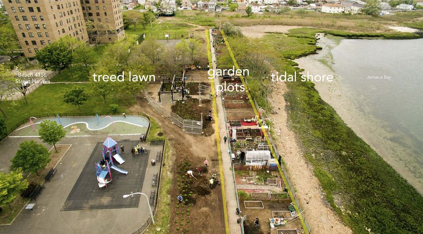
Figure 2. Photo of Beach 41st Street Houses with tidal shore, garden plots, and treed lawn identified.
Photo by Mehdi Salehi, New School Tishman Environment and Design Center.SOCIAL & CULTURAL GEOGRAPHY 9
Tidal shore
Because the Rockaways were historically a barrier island, flood events are common and
becoming increasingly so with the changing sediment balance in the bay, the rise of sea
levels, and the increase in intense storm events in a context of climate change. Situated
adjacent to the Norton Basin of Jamaica Bay, the shore, the plots, and the lawn of Beach
41st Street Houses all regularly flood at high tide and in storms, and flooded with
particular severity after Hurricane Sandy. Water is a powerful, boundary-crossing actant,
with waves lapping into garden plots and soggy lawn patches hydraulically connected
to the bay. Additionally, other non-human actants, including avian and aquatic life, are
a visible presence at the shoreline. New York City is located on the East Coast flyway,
which is a transcontinental corridor for bird migration; and Jamaica Bay is an important
site for Atlantic Ocean fish breeding.
Our team worked with NYCHA to identify B41 Garden as a site for adaptation through
design and research. Following Hurricane Sandy, NYCHA told gardeners at B41 to stop
gardening, because the plots had flooded and they were not sure of the safety of the
soil. NYCHA staff suggested to our team that perhaps the garden should be re-located
away from the water’s edge, and we began by assessing alternate sites. But, in talking
with the gardeners, many had a strong attachment to their coastal site – despite its
vulnerabilities. Only one intrepid family continued to garden in the year after Sandy, in
spite of the gardening ban. But others were eager to return. The waterfront views,
breezes, and birds exerted a powerful influence on the gardeners, who told us they
connected deeply to these aspects of the site as part of their attachment to that place.
At the same time, among residents and staff, there was some confusion over who
‘owns’ the shoreline, with numerous interviewees telling us that it ‘belonged to the NYC
Parks Department’ rather than NYCHA. In the eyes of residents, the wetland exists as
a liminal, ‘wilder’ space that is perceived quite differently from the regularly maintained
lawns, playgrounds, and pathways that are operated by NYCHA staff. The ownership was
not initially clear to us either, but our inquiries with NYC Parks and the Mayor’s Office
revealed that the land is part of NYCHA’s holdings. It is possible the shoreline may be
reshaped in the future, as the NYC Office of Recovery and Resiliency has examined the
Edgemere neighbourhood for potential construction of ‘Raised Shorelines’ (slightly
elevated edges). Paralleling the ambiguity over who owns the shorefront in the eyes
of the residents, the garden does not appear on any municipal map. City officials
conducted site visits to assess the potential for raised shorelines and some were
surprised to find an active community garden at the site. At the same time, NYC
Department of Housing Preservation and Development (HPD) is implementing selected
waterfront home relocation to parcels further inland. HPD initiated a neighbourhood-
scale planning process entitled the Resilient Edgemere Community Planning Initiative
(NYC HPD, 2017). Our embedded researcher attended public meetings in the neighbour-
hood, drawing attention to the presence of the B41 Garden and its constituents. While
various government agencies consider how to manage the shoreline in the future, large-
scale forces of the bay’s bathymetry, the size and frequency of the tides, storm events,
and climate change continue to exert their own pressures.
Through our process of examining the jurisdiction of the site, we learned that any
transformation of the Beach 41st St shoreline triggers a host of regulatory frameworks.10 L. K. CAMPBELL ET AL. Any disposition, demolition, or under-utilization of NYCHA property triggers a Section 18 easement of the 1937 Federal Housing Law (HUD, 2017). Any earth moving or construc- tion beneath the 3 meter elevation line next to tidal wetland is subject to state tidal regulation laws, according to Article 25, Environmental Conservation Law 6NYCRR part 66 (New York State Department of Environmental Conservation [NYSDEC], 2017). Finally, the entire Rockaway Peninsula and Jamaica Bay region is under study by the US Army Corps of Engineers and New York State Department of Environmental Conservation for potential coastal protection measures (U.S. Army Corps of Engineers, 2017). At one point we made design proposals for moveable planter boxes or plantable berms along the waterfront. But given this regulatory context, the ongoing challenges of both bureau- cratic control as well as flooding, and the size of our design budget, we did not do any construction in the tidal shore. Instead, we followed the lead of gardeners, stewards, and fisherman who engage with the shore in its current state (described below) – and organized shorefront clean-up and native plant identification workshops – to reinforce and shape further attachments. Despite the jurisdictional complexity and ambiguous future, the coast offers numer- ous human-nonhuman encounters in its present state, particularly because of unruly actants that penetrate the different areas – often in response to the currents and tides as actants. Some of the gardeners engage in shorefront clean-up – removing plastic debris that washes up in the reedy wetland area, or paying neighbours to cut back poison ivy that persistently returns along the fence line. A robust saltwater marsh forms the narrow, curved shoreline. On the western side of the site, these marsh grasses demonstrate their capacity to move inland toward the garden plots and the lawn, forming a meadow. We took cues from these fast-growing marsh grasses in developing our design approach for the lawn space, described below. One group of gardeners purchased a lawnmower, cutting back the grasses when they perceive them as getting ‘too high’ or coming ‘too close’ to the garden plots. Other local residents have embraced the shoreline as a place to interact with bay, fish, plants, and sky. A group of men who call themselves the ‘Bay Rats’ fish, barbeque, and socialize in a makeshift structure at the end of a dead-end street, just past the bulk trash dumpster and parking area, adjacent to the garden. The tidal beach next to the club- house is largely comprised of rocks and broken glass – evidence of years of accumulated detritus from human use. Despite being in close proximity and having convivial relations with the gardeners, there is little material exchange between the gardeners and the Bay Rats. The Bay Rats discussed the idea of using fish gut as compost and soil amendment for the garden, but to our knowledge this remains a proposal. However, at least one of the Bay Rats was a former gardener. Other residents consider themselves stewards of the wetlands, including a nearby neighbour who founded the Norton Basin Edgemere Stewardship Group. A self-reported ‘guardian of the bay,’ she described removing 35 bags of garbage per week since moving to the area in 2002 as well as removing invasive plants like mugwort and phragmites. Our initial design impetus was to create more boundary-crossings between shore and plots; we proposed a small pier with floating gardens that was anchored to a concrete pad, coupled with access to the shoreline via a lockable gate between one garden plot and the bay. This steward claimed that the fragile saltmarsh would be damaged by foot traffic, and noted that the existing fence was an important protective barrier to keep humans away from the shoreline; some
SOCIAL & CULTURAL GEOGRAPHY        11

gardeners were concerned about loss of a plot to create access to the bay; and NYCHA
staff raised safety concerns about accessing the shore. All of this feedback led to us
eliminating these features from our design.
   Finally, stretching beyond B41 Houses and the Bay Rats’ clubhouse lies a network of
desire lines and informal trails that wrap around the edge of Norton Basin. NYC Parks has
a proposal in the planning stage for a Jamaica Bayfront Trail that would connect existing
public greenspaces along this shoreline. We sent emails and had phone calls with
agency representatives to let them know about the garden and to suggest potential
connections with Beach 41st Street Houses. One proposed trail route goes inland, around
the NYCHA grounds, losing contact with the shoreline and missing these spaces of
coastal encounter, whereas another proposed route shows a dotted line that traverses
the NYCHA grounds. We appreciate the power of this dotted line in acknowledging the
potential connections to a community that is often ignored in planning processes. Given
the shifting nature of the coastline due to climactic, biophysical, and political pressures –
the location and physical form of these trails and connections remains to be determined
at the time of this writing.

Garden plots
Although we are use the term ‘community garden’ as a shorthand to refer to B41
Garden, it is important to note that these 30 individual plots more closely resemble an
allotment garden governance structure. An individual or family gets their own dedi-
cated, fenced area to manage; the overall space is not managed collectively as
a commons. These plots are assigned via a request system that is managed by NYCHA
and gardeners must reapply every year, which can generate uncertainty mixed with
territoriality. Our designer and community organizer attempted to work with gardeners
to subdivide plots that were too large to be maintained by an individual with temporary
snow fencing. But the memory of plots as individual spaces was persistent and difficult
to shift. Even when plots lay fallow, they were considered ‘claimed,’ which can create
tension with more productive growers who would like additional space. Reassigning or
subdividing plots remains a highly delicate act. Recognizing that many of the gardeners
were senior citizens, our community organizer aimed to recruit more youth to work with
the garden. Despite a community centre with youth programming being just one block
away, that centre was not engaged with the garden. The organizer recruited youth from
the centre to participate in a demonstration garden. During the course of the design-
research project, the gardeners also created a NYCHA Resident Green Committee to
strengthen their organizational capacity. They have a president and secretary, keep
meeting notes, and apply for grants to support programming on the site. This
Resident Green Committee is an attempt by local residents to align with the organiza-
tional structure at NYCHA in order to build more lasting group institutional knowledge
and continuity, given that plots are reallocated every year.
   Gardeners are the primary land managers of their plots – so they largely determine
the material inputs and structural configurations within their space – but they do so in
the context of a broader assemblage that shapes their actions, including NYCHA rules,
unruly actants, and access to material resources. In the past, NYCHA rules required
residents to plant only annuals, so that grounds staff could consider gardens as
12      L. K. CAMPBELL ET AL.

‘temporary’ uses on the land; but these rules were renegotiated in 2002 to allow the
planting of perennials and shrubs (Bennaton, 2009). B41 Garden was established in the
1990s; the perennial plants at the site form multi-year attachments with the gardeners
as they return anew each spring, grow throughout summer, are cut back in fall, and go
dormant in winter. So, while gardeners must re-apply for plots each year, both plant
structures and human memories demonstrate abiding relations. Many gardeners save
seeds, share plants, and select plants that have edible or medicinal uses, cultural, or
personal significance. Planting practices range from agricultural-style row cropping (e.g.
beans, garlic, peppers, collards), to raised beds (e.g. tomatoes, basil, other herbs), to
decorative borders of flowers (e.g. daffodils, lilies, marigolds). Gardeners adaptively
source and reuse materials (such as used furniture or pallets from the nearby bulk
trash area) in creating benches, shade structures, and trellises. One novice gardener
created, entirely from found objects, a self-designed greenhouse. Although enclosed
structures are technically against NYCHA rules, this gardener’s creativity was honoured
with an award at the 2016 NYCHA Garden and Greening Awards Ceremony.
    Some actants can be unruly and unwanted. The ongoing human labour required to keep
plots from becoming overrun with weeds presents a substantial and strongly voiced
challenge to gardeners – especially those who may be elderly, ill, or disabled. Particularly
troublesome to the gardeners is the poison ivy that grows on the fence. Some gardeners put
down fabric or carpet as a weed barrier; others pay a group of men to remove plants on the
fence. The porous boundary between the tidal shore and the garden plots is penetrated by
the unruly actant of brackish water. Several gardeners have developed adaptations for
‘living with water,’ including building raised beds and creating trenches between beds.
Many gardeners store their tools in lightweight boxes and shopping carts so that they can
be brought up to their apartments before storms. We used low-cost strategies to support
gardeners, while also recognizing that plots and lawn will continue to flood. These design
strategies included: working with NYCHA to secure lumber for raised beds, developing new
systems to access soil on an ongoing basis, and offering free sandbags for gardeners to
shore up their plots in a temporary way.
    Fresh water is a crucial material input required for creating a successful garden. In the
past, NYCHA provided one spigot for freshwater access near the centre of the plots on
the sidewalk. Over time, this system had broken. It took the work of the community
organizer and B41 residents to draw attention to the need to repair this system. NYCHA
made repairs to the central spigot and redesigned the system to run hoses along the 30
plots with individual spigots for each gardener. This system was highly successful in the
2015 growing season. In the spring of 2016, however, the water was not turned on for
several hot weeks. We learned that only one worker on staff had the knowhow and
correct tool to turn the water system on – and he was on vacation in Puerto Rico. This
one key node in the water assemblage could enable or constrain the ability for the
system to function. Gardeners made do, bringing water in buckets from their homes
until the system was reinstated. To build more redundancy, our designer created a free-
standing, individual drip-irrigation system that uses contractor buckets, suspended from
bamboo tripod poles. If the water system breaks again, buckets can be filled off-site and
installed to slowly drip water on the plots.
    Receiving sufficient, clean organic soil is another consistent challenge for urban
gardeners, particularly for gardeners on public housing grounds that are not able to
SOCIAL & CULTURAL GEOGRAPHY 13 easily access or direct the material flows of such a resource. Concerns over potential soil contaminants after Sandy led NYCHA to enact the gardening ban at B41 Garden for over a year. Once the soil was tested and deemed safe for gardening, and funding was secured to support a community organizer and material resources, the gardeners were able to begin again. Our team helped support the gardeners’ 2014–2017 growing seasons with a mix of privately-funded soils purchased from a regional nursery, publicly- offered compost sourced via NYCHA, wood for raised bed box-building sourced via NYCHA, and plants sourced from private funds and NYCHA supplies. The approximately 650 community gardens in New York City that are part of the NYC Parks GreenThumb program can register to receive free soil, compost, clean fill, or mulch by attending a workshop and filling out a simple, one page online form. However, gardens on NYCHA grounds are not part of the GreenThumb system. The NYCHA Garden and Greening Program aims to provide shipments of soil, compost, lumber, and plants to these numerous sites (Bennaton, 2009), however the support staff for this program is signifi- cantly smaller than that which is available for GreenThumb gardeners. Over the last decade and due to budget constraints, the NYCHA program went from having two citywide coordinators, to one single coordinator, to no coordinator. These coordinators’ work had been supplemented by paid seasonal consultants (like our community orga- nizer), but those consultancies ended in 2015. The Gardening and Greening Program is mentioned in the Next Generation NYCHA 10-year plan as the sort of ‘direct service’ provision that does not have sufficient funding and requires a partnership model, although the specific model for that program area is not named (New York City Housing Authority [NYCHA], 2015, pp. 93–96). Thus, we are mindful that beyond the duration of our project, there will be a substantial need to identify a consistent source of soil to support the ongoing needs of the gardeners. Ultimately, our design and organizing approach consisted of supporting gardeners to remain in situ, while helping to strengthen and re-shape their attachment to this site and to each other. In so doing, we hoped that these social ties would sustain gardeners through the next wet event. Going beyond the traditional design charrette, we held interactive workshops with gardeners – focusing on creating custom signage and lighting for the garden. By encouraging gardeners to adorn their plots with expressions of identity and love, we sought to reinforce place attachment, to commu- nicate the intent of the garden to all residents of B41st Street Houses, and to collect statements to put on flags that are the signage in the lawn. We also worked to strengthen social and material networks that extend beyond the site. Our embedded researcher was instrumental in catalysing the East Rockaway Growing Coalition that brought together members from B41 Garden with other greening groups on the peninsula, including Rockaway Waterfront Alliance, Rockaway Youth Task Force, and Edgemere Farm. The coalition applied for and received a grant to hire two urban agriculture summer interns to work across sites, sharing knowledge and labour in tending land at multiple locations. These sorts of organizational and material ties are crucial to sustaining B41 Garden in the long term, particularly in the context of ongoing resource constraints and changes to the NYCHA Garden and Greening pro- gram and the only temporary presence of our team at the site.
14      L. K. CAMPBELL ET AL.

Treed lawn
While considering the Beach 41st Street site, it is important to briefly situate these grounds in
the context of public housing landscape design, which has evolved over time. In the mid-
20th century, public housing often took the form of modernist, Le Corbusier-style ‘Tower in
the Park’ – i.e. high-rise buildings surrounded by lawns – as this was believed to maximize
open space and exposure to sunlight and fresh air (NYCHA, 2015). However, the late 20th
century saw a return to a desire for low- to mid-rise housing integrated with the streetscape.
From the 1970s to the 1990s, there was a turn toward the creation of ‘defensible space’ in
public housing, which focuses on the need to create a sense of territory and ownership in
a shared public space in order to deter negligence and crime. This approach to landscape
management intersected with concepts from criminology in the creation of the subfield
‘Crime Prevention through Environmental Design’ or CPTED (Newman, 1972, 1996). In 2015
the NextGeneration NYCHA plan recommitted to integrating CPTED principles into all
capital projects, shaping ‘everything from the small-scale, such as the use of shrubbery
and vegetation, to the large scale, promoting an increased use of public space and presence’
(NYCHA, 2015, p. 78). The Beach 41st Street Houses was constructed in 1973, consisting of
four mid-rise buildings containing 712 apartment units and one community centre situated
on 5.39 hectares of land. Institutional rules and aesthetics inform the form, function, and
plant selection in the NYCHA grounds. The Beach 41st Street grounds contain mown lawns
with large, landscape trees, occasional planting beds, and separate functional areas for
walking (sidewalks), children (playground), and sitting (benches), often divided by low
fences.
    The physical design, rules, and maintenance routines of Beach 41st Street Houses
emphasize cleanliness and security of the space. The lawn is a regulated space that is
demarcated with posted signs and rules, including ‘No BBQs or Picnics on NYCHA
Property’ and ‘Keep Dogs off Grass – It’s the Law; Minimum Fine $100-$250.’ Certain
lawn areas include generator-powered flood lights, installed through the New York City
Police Department Omnipresence program, meant to enhance night-time visibility and
deter crime. The primary management activities that we observed occurring in the lawn
were ongoing trash removal by maintenance workers and regular mowing of the grass
with ride-along mowers. NYCHA regulates the presence of pets in apartments as well as
on the grounds. For example, residents told us that there are certain size and breed
restrictions written into their apartment leases. There is no official dog run or off-leash
area on the grounds for dogs to use; though some residents unofficially allow their dogs
on the lawn, in spite of the posted rules.
    The process of gaining permission to intervene in the NYCHA lawn was lengthy due
to the need to build trust and shared understanding about project scope, while also
addressing concerns over risk and liability in a capital project. A license agreement was
secured for Till Design, the landscape architecture practice, and our contractor, Natural
Garden Landscapes (NGL), that allowed our team to work within a designated project
area for a specified period of time. In order for NGL to work in that area, they had to
demonstrate having sufficient insurance and ensure the health and safety of all workers
on site. Unlike many private construction contractors, NGL sought to work with paid
apprentices in order to provide training in woodworking and to work with residents in
the implementation of the landscape design. This different approach to labour was
SOCIAL & CULTURAL GEOGRAPHY 15
challenging within the safety and training protocols, and so the apprenticeship program
was adjusted to meet these requirements. In addition to NGL, our team partnered with
Green City Force, a non-profit youth development and greening organization with prior
experience working on NYCHA grounds.
With permission to work on the grounds secured, we sought to be responsive to
gardener interests and needs, including concerns around dog faeces and unleashed
dogs. In one of our design workshops a gardener sat in a chair along the concrete path,
rather than sit on the picnic blanket we had laid out. ‘She had a phobia of the grass,’
another garden explained, due to the fear of stepping into dog waste. In response, our
community organizer purchased a dog waste system, consisting of a bag dispenser and
waste basket that was installed at the entry of the lawn area. At the same time, residents’
fears have been realized as, on various occasions, both people and smaller animals have
been attacked by unleashed dogs. Yet, fear of reprisal for reporting dog owners
responsible for these encounters, coupled with persistent frustration that nothing will
ever change, leads to inaction. An earlier design proposal to create a dog run that was
initially met with great enthusiasm did not develop due to lack of sufficient budget and
lack of precedent for this type of intervention on NYCHA grounds.
Our design strategy worked with the lawn assemblage, recognizing the entrenched
routines around maintenance and aesthetics – but searching for apertures for change.
The design balanced permanent elements, such as a pergola; with other elements that
are easier to rebuild, such as bamboo fences that enclose garden plots; with temporary
gestures that were meant to claim space, but not necessarily meant to last. Our first
landscape intervention was directed by our community organizer and supported by
NYCHA Garden and Greening – the fall planting of annual, ornamental chrysanthemums
and cabbages at key entry points to buildings. Albeit ephemeral, the act of stewardship
was a symbol of our shared commitment to the site. Our approach to lighting similarly
made claims on the space – with gardeners deciding to spell out ‘Beach 41st Street’ in
flexible lighting arrayed on the garden fence. Over many periods of iterative design,
community input, approval from NYCHA and our funder, we proposed creating
a gathering space that would be a focal point for the grounds. We heard from gardeners
that they wanted a multi-use space for meetings, birthday parties, church group gather-
ings, and socializing in the shade. Our new design consisted of a hand-built pergola –
a shade structure made of a wooden frame and slate roof assembled by NGL and their
apprentices; planting beds with salt-tolerant ornamental plants planted with and for
community residents and volunteers; and newly seeded lawns areas with two wooden
benches and several tripods adorned with messages of love crafted through our
workshops.
The particular arrangement of the design elements was finalized through an iterative
process working with NYCHA residents and staff. Over time, we became attuned to the
capacities and needs of the actors and actants through our ongoing physical presence at
the site. The salt-water floodplain forms a part of this assemblage that affects and is
affected by the people, plants, and built features that we worked with on the site. In
response to the frequent flooding issues on low lying areas in the lawn, the design
proposal included new planting beds with species that can tolerate inundation. These
planting beds are meant to hold extra water and allow it to be slowly absorbed by the
soil. To prepare the grounds for successful planting, massive inputs of human labour and16 L. K. CAMPBELL ET AL.
soil were required. Fifteen members of Green City Force provided labour, hand tools,
and use of a backhoe. They spent two weeks excavating the ground – a low-quality fill –
and amending it with soil, compost, and sand. Following this bed preparation stage, as
well as weeks of community outreach, we engaged more than 100 residents, neigh-
bours, and friends on a large-scale volunteer planting day on 21 May 2016 in which
more than 700 plants were installed, mulched, and watered.
Through both the landscape design elements and the volunteer planting day we sought to
amplify boundary-crossings between the garden plots and the lawn. Without direction from
our team, the gardeners planted a row of daffodil bulbs along the central sidewalk, helping to
beautify that pathway as a key axis. Daffodils were selected because they are planted in the
fall, but emerge as an early sign of spring with a burst of yellow colour that signifies that
someone is tending the site. During one site visit, we observed that resident gardeners were
‘jumping the fence’ to plant hostas and other ornamental plants on the other side of the
sidewalk in the lawn. Responsive to this impulse, our design proposed 6 new hexagonal
garden plots inside the lawn surrounded by handmade bamboo fences created by NGL and
Green City Force. During the community planting day, volunteers also ‘jumped the fence’ to
work with some of the resident gardeners on maintenance of their plots. At a summer potluck,
we observed that one gardener had created a new vegetable garden across the path, and
another had rigged up a shade structure next to their garden. We take these boundary
crossings as subtle, ephemeral signs of transformation in the interaction with the lawn space.
Discussion
We have interrogated and traced the structural and emergent power relations in the
actor-network/contact zone of the B41st Street Houses across three assemblages. While
we acknowledge that the areas are not neat and distinct, but blurry and porous, we can
nonetheless detect that the assemblages are arranged differently in the shore, the
garden, and the lawn. Each assemblage area has a different governance arrangement
and set of stewardship practices and is discussed in turn.
The tidal shore, with its multiple, overlapping jurisdictions, appears as an ambiguous or
liminal space. In alignment with Lehman (2014)’s findings that coastal networks are permeated
with uncertainty, we found ourselves with limited ability to create changes in the shoreline
assemblage. The shore’s ownership was unclear; its boundary at the edge of the bay is shifting
in the face of storms and climate change, and its future remains indeterminate as various
capital-intensive proposals for shoreline retrofits and bayfront trails circulate through policy
arenas. Nonhuman actants include tides that vary in rhythmic, but sometimes extreme ways;
birds, fish, and breezes that invite curious humans to the shore; and coastal debris that returns
recalcitrantly along the edge. We experimented with (and abandoned) creating more access
points between the garden plots and the tidal shore in the form of a lockable gate–until we
realized concerns about coastal fragility, public safety, and garden territory. Meanwhile, some
human users – particularly fisherman, ecological stewards, and trail explorers – already seek
out engagement with the shore. We took our cues from these entanglements, documenting
the informal trails, engaging in temporary acts of debris removal, and drawing attention to the
potential linkages between Beach 41st Street Houses and other bayfront open spaces. By
creating visibility through social media, meetings, and field tours, we hope that the stake of
Beach 41st residents is made more prominent in these ongoing negotiations.You can also read