Medieval long-wall construction on the Mongolian Steppe during the eleventh to thirteenth centuries AD
←
→
Page content transcription
If your browser does not render page correctly, please read the page content below
Antiquity 2020 Vol. 0 (0): 1–18
https://doi.org/10.15184/aqy.2020.51

Research Article

Medieval long-wall construction on the Mongolian
Steppe during the eleventh to thirteenth centuries AD
Gideon Shelach-Lavi1, *, Ido Wachtel2, Dan Golan3, Otgonjargal Batzorig4,
Chunag Amartuvshin5, Ronnie Ellenblum6 & William Honeychurch7
1
  Department of Asian Studies, Hebrew University of Jerusalem, Israel
2
  Institute of Archaeology, Hebrew University of Jerusalem, Israel
3
  Independent Researcher
4
  Oyu Tolgoi Mines, Inc., Ulaanbaatar, Mongolia
5
  Institute of History and Archaeology, Mongolian Academy of Sciences, Ulaanbaatar, Mongolia
6
  Department of Geography, Hebrew University of Jerusalem, Israel
7
  Department of Anthropology, Yale University, New Haven, USA
* Author for correspondence: ✉ gideon.shelach@mail.huji.ac.il

                                                           The long walls of China and the Eurasian Steppe are
                                                           considered to have functioned as either defensive
                                                           structures against aggressive nomadic tribes, or as ele-
                                                           ments to control the movement of local nomadic
                                                           groups following imperialist expansion. This article
                                                           focuses on a hitherto understudied 737km-long
                                                           medieval wall running from northern China into
                                                           north-eastern Mongolia. Built by either the Liao or
                                                           Jin Dynasties, the wall features numerous auxiliary
                                                           structures that hint at its function. In research rele-
                                                           vant to interpreting other Eurasian and global wall-
                                                           building episodes, the authors employ extensive arch-
                                                           aeological survey and GIS analysis to understand bet-
                                                           ter the reasons behind the wall’s construction, as well
                                                           as its various possible functions.

    Keywords: China, Mongolia, Liao, Jin, long walls, pastoralism

Introduction
Periodic construction and use of long (or ‘great’) walls occurred in China from the last cen-
turies BC to the seventeenth century AD (Waldron 1990; Jing 2006; Pines 2018). These
walls are often considered to demarcate an ecological boundary between agriculture and pas-
toralism—the classic ‘steppe vs sown’ division (Lattimore 1937). The wall that forms the
focus of this article (the ‘northern line’ in Figure 1), however, is located deep inside the east-
ern Steppe zone, and could not have represented a border between ecological zones. This wall
forms one part of a complex wall system that was built sometime between the eleventh to the

Received: 13 June 2019; Revised: 15 August 2019; Accepted: 11 September 2019
© Antiquity Publications Ltd, 2020

                                                       1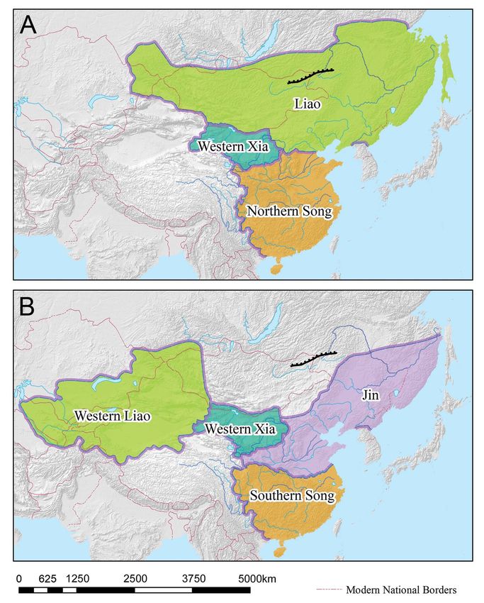
Fig. 1 - Colour online, Colour in print                                             Gideon Shelach‐Lavi et al.

                                          Figure 1. General locations of the medieval wall systems mentioned in the text (after Tan 1996).

                                          thirteenth centuries AD (Figure 1), and spanned over 3500km (Jing & Miao 2008: 22). If all
                                          of the parallel wall lines are taken into account, however, the accumulated length exceeds
                                          6500km (Ping 2008: 101), making it one of the longest wall complexes, and largest monu-
                                          ments, ever constructed. Despite its massive size, little research has been done on this
                                          medieval wall system, and it is barely mentioned in the most authoritative historical
                                          works. Waldron’s (1990) The Great Wall of China: from history to myth, for example, never
                                          mentions medieval wall-building episodes. Similarly, the Cambridge history of China (Franke
                                          & Twitchett 2008) dedicates only one short paragraph to a schematic description of the walls
                                          (Franke 2008: 250).
                                             Beyond basic questions of when the northern wall was built and by whom, its unique
                                          characteristics raise the more pressing issue of why it was constructed. Was it, for example,
                                          a military installation built to defend a territory against invading armies? Did it function
                                          as a symbolic demarcation of a frontier borderland? Or did deteriorating climatic and eco-
                                          logical conditions catalyse a need to control and monitor the movement of populations across
                                          the walls and into state-controlled lands? Our study offers a first step towards addressing these
                                          questions.
                                             This article presents the results of fieldwork focusing on a section of the northern wall
                                          located in Dornod Province, north-eastern Mongolia. Intensive archaeological survey, GIS
                                          analysis, drone photography and the analysis of satellite imagery allow us to explore the func-
                                          tion of the wall and the logic behind its construction.

                                          Historical background
                                          The tenth to thirteenth centuries AD were a dynamic period in the history of Central and
                                          East Asia. The zenith of nomadic power in Eurasia culminated in the early thirteenth century

                                          © Antiquity Publications Ltd, 2020
                                                                                                  2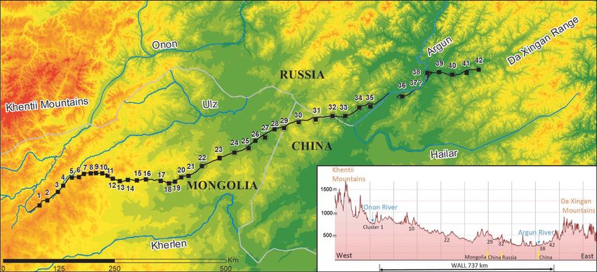
Medieval long‐wall construction on the Mongolian Steppe during the eleventh to thirteenth centuries AD

with the rise of the Mongol Empire, the largest land empire ever established (Biran 2007;
Fitzhugh et al. 2013). The two dynasties most often associated with construction of the medi-
eval wall systems in question are the Khitan-Liao (907–1125) and the Jin (1115–1234), both
of which were established by nomadic or semi-nomadic groups. By the end of the first
millennium AD, the Khitan people had conquered large parts of Manchuria, eastern
Inner Mongolia and the Mongolian Steppe to form the Khitan-Liao Empire (Figure 2A).
The Liao Dynasty combined Chinese and nomadic elements and was a formidable enemy
of the Northern Song (960–1127), the reigning Chinese dynasty to the south. During the
early twelfth century, the Jurchen tribes of Manchuria—previously vassals of the Liao—united
and quickly destroyed the Liao and pushed the Song southward. As the Jin Dynasty, they estab-
lished rule over all of north China until, by the mid thirteenth century, it was conquered by the
Mongol armies (Figure 2B).
    Although the Liao and Jin Dynasties, along with the contemporaneous Northern and
Southern Song dynasties, kept extensive historical records, none of those histories or related
documents mention the construction of these wall systems. This is perhaps surprising
given the massive undertaking that would have demanded a large workforce over a long
period of time.
    The Chinese historian Wang Guowei (1877–1927) suggested that the wall systems were
built by the Jin Dynasty over a short period of time, in their attempt to repel the invasion of
Chinggis Khan’s Mongol armies (Wang 1921). In Western scholarship, Lattimore (1963: 5)
attributed the walls’ construction to the early Jin Dynasty, associating it with a change in
administrative policy from the Liao Dynasty’s active involvement in the Mongolian Steppe
to the retreat eastwards and defensive policy adopted by the Jin. Both of these hypotheses,
however, seem to refer mainly to the southern wall lines, which resemble the known historic
borders of the Jin (compare Figures 1 & 2B). Indeed, the southern wall lines continue to be
assigned to the Jin period (Jing 2006; Franke 2008: 250; Jing & Miao 2008; Sun 2010),
although some scholars have recently challenged this, attributing at least the westernmost
parts of the southern wall lines to the Western Xia Dynasty (1038–1227) (Figure 2; Kovalev
& Erdenebaatar 2010).
    Historical analysis suggests that the northern wall line, on which our research focuses, was
located beyond the borders of the Jin Dynasty, but within the area controlled by the Liao
(compare Figures 1 and 2A) (Tan 1996; Franke 2008: 236–37; Ma 2013). Thus, our work-
ing hypothesis concerning this northernmost line (but not necessarily for other parts of the
medieval wall system) is that it was planned and built by the Liao Dynasty in order to meet
specific strategic objectives. The presence of the Liao in the region, from at least the eleventh
century, is undisputable, and some records suggest the existence of fortifications in this region
(Ma 2013), although Liao official history (Liaoshi 遼史) does not mention the construction
of a substantial wall in these northern territories.

Archaeological research on the medieval ‘Great Walls’
Surprisingly little archaeological work has concentrated on this medieval wall system, particu-
larly the northern section. A survey of the different southern sub-lines in China has been con-
ducted (Sun & Wang 2008; Sun 2010: 142–46), and the reconstructed wall line appears in

                                                                    © Antiquity Publications Ltd, 2020
                                                  3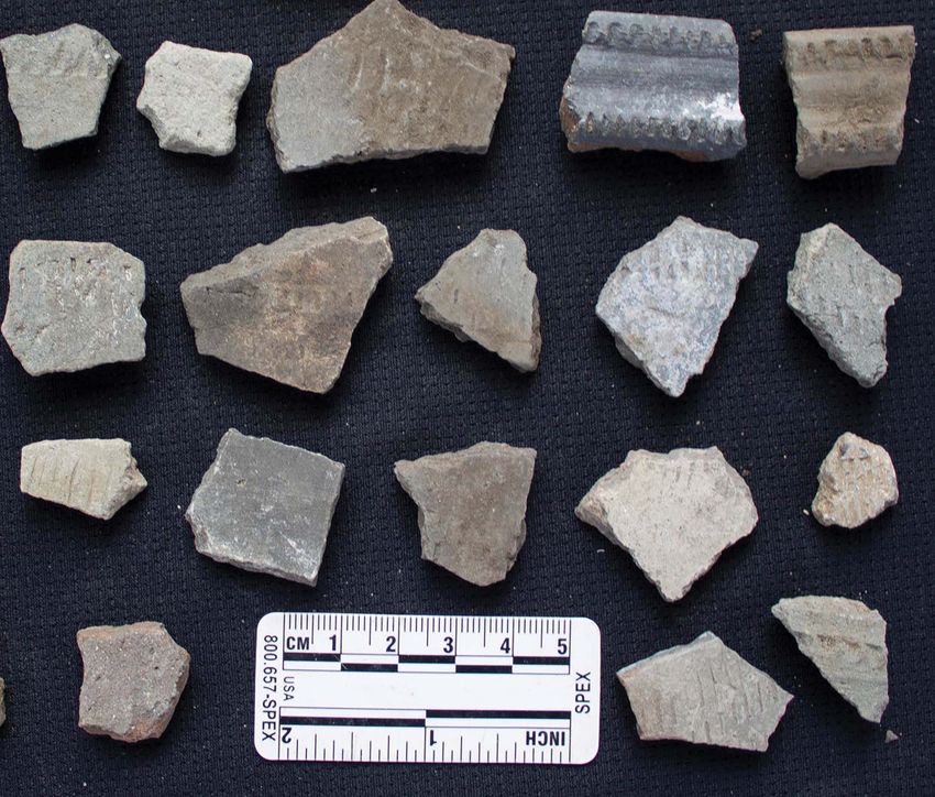
Fig. 2 - Colour online, Colour in print                                            Gideon Shelach‐Lavi et al.

                                          Figure 2. Maps of East Asia and Mongolia during the eleventh (A) and twelfth (B) centuries AD. The route of the
                                          northern wall line is marked in black on the two maps (figure by the authors).

                                          the Chinese historical atlas (Tan 1996). This survey work has documented the dimensions of
                                          the aboveground remains, tracing and mapping the visible wall lines. In some cases, the
                                          remains of auxiliary features, such as towers and camps, are also documented (e.g. Jing
                                          2006; Jing & Miao 2008).

                                          © Antiquity Publications Ltd, 2020
                                                                                                4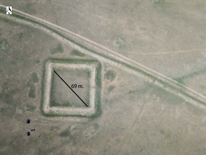
Medieval long‐wall construction on the Mongolian Steppe during the eleventh to thirteenth centuries AD

    The northern line of the wall has received far less research attention. Early descriptions of
this wall and its associated features date back to eighteenth-century European travellers (see
Lunkov et al. 2011). More recently, Chinese archaeologists have carried out sporadic docu-
mentation on parts of the northern line, while Russian archaeologists have conducted more
extensive field research on the part of the wall located in south-eastern Siberia and in
Mongolia. In the 1950s, Kiselev (1958) dated the northern wall to the eleventh to twelfth
centuries AD based on pottery collected from the surface of a circular structure located to
the south of the wall. Later work includes the Soviet-Mongolian expedition in the late
1980s, which excavated sections of the wall in north-eastern Mongolia (Chichagov et al.
1995). The Russian archaeologists Kirillov and Kovychev (2002) mapped and conducted
test excavations on Siberian sections of the wall and associated forts (for a more recent detailed
analysis of these Siberian sections, see Lunkov et al. (2011)). The consensus among Russian
and Mongolian archaeologists is that the northern wall should date to the Liao period. Its
function and its location within Liao territory, however, have so far not been addressed.

Current field research on the wall and associated structures in
north-eastern Mongolia
At the outset of our project, we used high-resolution satellite imagery to identify systematic-
ally the line of the wall and any structures associated with it. This remote-sensing approach
revealed that the structures along the wall are arranged in distinct clusters. We have traced the
entire length of the wall, which, at 737km, corresponds well with previous estimates (Lunkov
et al. 2011; Ma 2013). Along the wall line, we identified 72 individual structures arranged in
42 clusters (see Table S1 in the online supplementary material (OSM)). This is far more than
the few structures described in even the most detailed published descriptions (e.g. Baasan
2006; Lunkov et al. 2011; Ma 2013). The clusters of structures are spread more or less evenly
along the wall line, with distances between clusters varying from 8–29km (with one irregular
48km interval where the wall crosses the Argun River). We therefore suggest that travelling
between most clusters on horseback, using ox-carts or even on foot would take no more
than a few hours.
    Fieldwork conducted in 2018 focused on exploring the wall line and a selection of struc-
ture clusters, located in Dornod Province. This collaborative project involved archaeologists
from the Hebrew University, the Mongolian Academy of Sciences and Yale University, and
consisted of three components:

         1. A systematic pedestrian survey of areas around a small section of the wall
            near cluster 27.
         2. A field survey, mapping and drone photography of 16 structures (in add-
            ition to the three structures of cluster 27).
         3. Vehicular reconnaissance and observations along the wall to its western-
            most terminus.

The intensive survey was based on a well-established protocol previously used in north-east
China (Shelach-Lavi et al. 2016). Two groups were each assigned a different survey tract

                                                                    © Antiquity Publications Ltd, 2020
                                                  5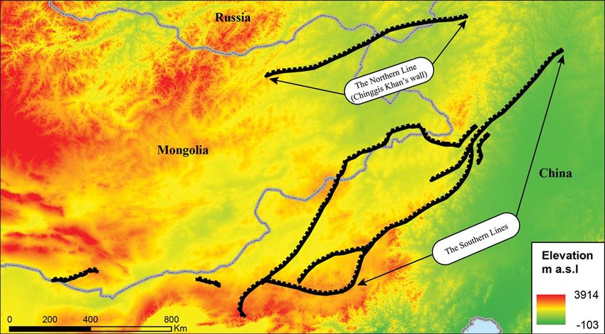
Fig. 3 - Colour online, Colour in print                                                 Gideon Shelach‐Lavi et al.

                                          Figure 3. Survey results: left) quadrants surveyed, and the location of the collections and features; right) collection units
                                          made around cluster 27. The size of each circle represents the density of artefacts found in the collection; top right)
                                          distribution of potsherds; bottom right) distribution of stone artefacts. The area of each collection unit is marked
                                          with a black line and the density of artefacts found within them is indicated by the colour (figure by the authors).

                                          marked on a high-resolution satellite image. As our predominant interest lies in non-
                                          sedentary societies and small communities in the vicinity of the wall, we anticipated that
                                          some sites under investigation would be small, with low densities of surface artefacts. During
                                          the survey, team members therefore walked slowly in a line, at 20m-interval spacing, carefully
                                          observing the ground for single artefacts. The basic unit of data recording was surface collec-
                                          tion, established when the survey line encountered a threshold of three artefacts spread no
                                          more than 50m from each other (although when only a single artefact was found it was
                                          also recorded as a ‘findspot’). When artefacts were encountered by the survey group, the
                                          line halted to allow for intensive surface inspection. The boundaries of the artefact distribu-
                                          tion (i.e. a collection unit) were marked on the printed satellite image and recorded with a
                                          GPS device. To ensure high resolution, we kept collection units small (0.67ha on average),
                                          and if artefacts continued to be found towards the periphery of an existing unit, we proceeded
                                          to open a new collection unit. This method is both efficient and accurate, as it does not
                                          depend on the subjective definition of a site, and the recording of the units is very accurate.
                                             We intensively surveyed a total area of 16.8km2 across two separate but nearby quadrants
                                          (Figure 3, left). The first quadrant consisted of a larger survey area around cluster 27, proceed-
                                          ing from that cluster towards the wall line. The second quadrant comprised a rectangular area
                                          along the wall line and farther to the east (Figure 3). In total, we made 36 collections of

                                          © Antiquity Publications Ltd, 2020
                                                                                                       6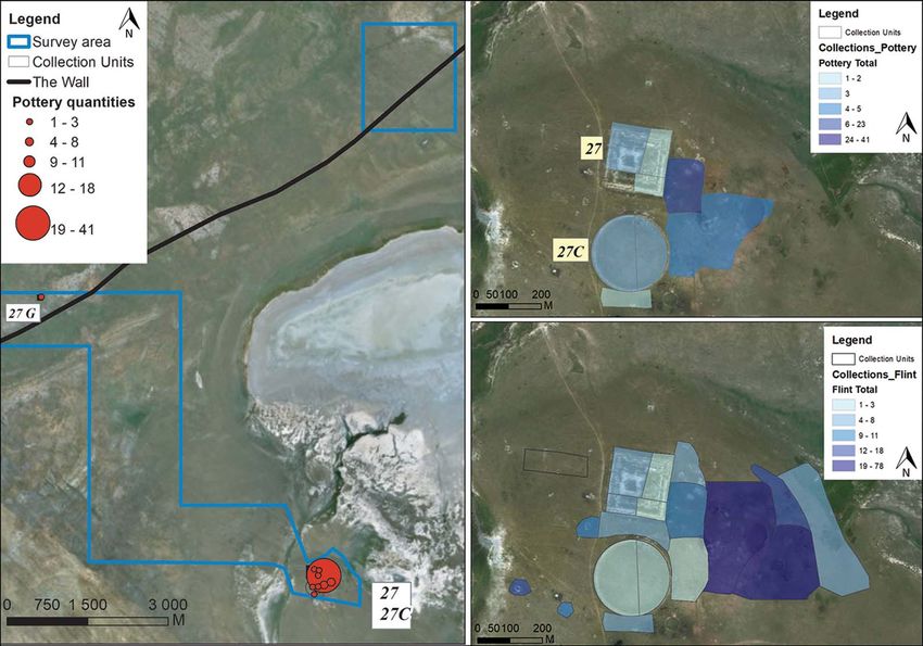
Fig. 4 - Colour online, Colour in print   Medieval long‐wall construction on the Mongolian Steppe during the eleventh to thirteenth centuries AD

                                          Figure 4. A typical collection of ceramic fragments found during our pedestrian survey from areas around cluster 27
                                          (photograph by the authors).

                                          artefacts, and the accumulated size of the collection units was 24.4ha. The distribution of
                                          collection units and artefacts clearly shows that the only major concentration of artefacts is
                                          located around the structures comprising cluster 27. Here, we recovered large quantities of
                                          pot sherds and lithic artefacts (Figure 3); other collections usually contained one or two
                                          stray objects for which we recorded the findspot.
                                              The most common finds were hard-fired greyware sherds with punctate decorations.
                                          Mongolian archaeologists and others have identified these as Liao/Khitan ceramics (Figure 4;
                                          Makino 2007). Our assemblages correspond well with those from previously published
                                          archaeological surveys and excavations along the wall in Mongolia and Russia (Kiselev
                                          1958; Baasan 2006; Lunkov et al. 2011). Flint artefacts, including tools, flakes and cores,
                                          were also commonly encountered. The concentration of stone artefacts was especially
                                          dense at some collections near cluster 27, perhaps suggesting the location of Early to Middle
                                          Holocene sites (Janz et al. 2017).
                                              In addition to the systematic survey, we also surveyed in and around the structures at clus-
                                          ters 1, 2, 7, 12, 22, 23, 24, 26 and 28. Finds at these clusters were very similar to those at

                                                                                                                       © Antiquity Publications Ltd, 2020
                                                                                                  7
Gideon Shelach‐Lavi et al.

cluster 27. It seems clear that these clusters were centres of human activity probably contem-
poraneous with the wall being in use. The rectangular structures, for instance, could have
functioned as bases for people—soldiers, perhaps—who operated the wall system, and the
circular structures may have been used as animal corrals. These hypotheses, however, require
further research. The scarcity of finds in areas away from the structures, including near the
wall line, suggests that these places were not occupied and were subject to minimal human
activity.
    A metal detector was used during our surveys to find metallic artefacts, particularly coins,
that would allow us to date more accurately the use of the wall system. Although we recovered
some small artefacts, such as nails and buttons, no coins were found. While the ceramics we
recovered during the surveys are often dated to the Liao period (907–1125), they may well be
from slightly later periods. Efforts to refine the ceramic typology using comparative techni-
ques, as well as absolute dating of contexts associated with such ceramics in other parts of
Mongolia, are underway (Makino 2007: 32–37 & 71; Shiraishi & Tsogtbaatar 2009;
Park et al. 2019a).

Remains of the wall and accompanying structures
Although the wall is poorly preserved in some places, drone photography clearly shows that it
is a continuous structure. The better-preserved sections survive to 1m above ground level.
The current width of the wall is approximately 10m, some of which may be attributed to
collapse and/or erosion of upper portions. This corresponds to Lunkov et al.’s (2011: 105)
observations of the Russian section of the wall. Drone photography suggests the presence
of a narrow ditch on the northern side of the wall, as evidenced by thicker vegetation com-
pared to the southern side (Figure 5). In some places, especially on the westernmost parts of
the wall, we identified structural openings (near cluster 35 for example) that are also visible on
the satellite images. While it is possible that some of these openings are modern, we hypothe-
sise that most represent ancient gates. This theory will be explored in future excavations.
    We identified four major types of auxiliary structures through field survey and satellite
imagery: large rectangular/square structures (n = 42) with an average enclosed area of
1625m2; small rectangular structures (n = 11) ranging between 265 and 578m2 in area;
mini rectangular structures (n = 6) with estimated areas between 10 and 50m2; and circular
structures (n = 16), ranging in size from 4185–20106m2 (Figure 6). Lunkov et al. (2011:
116) suggest that these structures usually appear in pairs. Our survey of all the structures,
including those located on satellite images, however, shows that the large rectangular struc-
tures are focal features around which other features sometimes appear to cluster. These large
rectangular structures can appear alone (n = 24) or together in a cluster with other types of
structure (n = 18) (Table S1).
    The large rectangular structures are made of earthen walls that survive to a greater height
than the linear wall, in some places preserved to a height of 2m. In most cases, the layout is
approximately square, with the corners usually oriented to the cardinal directions. The width
of the walls at the corners of the best-preserved structures are wider, suggesting that they may
have supported additional structures on top of them. Occasionally, an opening is present in a
structure’s wall that may have served as the entrance. Furthermore, we often identified

© Antiquity Publications Ltd, 2020
                                                 8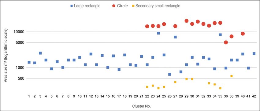
Fig. 5 - Colour online, Colour in print   Medieval long‐wall construction on the Mongolian Steppe during the eleventh to thirteenth centuries AD

                                          Figure 5. The wall line near cluster 12 (drone photograph by G. Shelach-Lavi).

                                          depressions circumscribing the walls. These most likely represent a surrounding ditch from
                                          which soil was excavated during construction of the earthen-walled features (Figures 5–6).
                                              The 11 small rectangular structures morphologically resemble their larger counterparts.
                                          Some of these small structures are located inside the larger ones, while others are located out-
                                          side, but in close proximity to the larger structures. The six mini rectangular structures were
                                          identified on satellite imagery but were not visited on the ground. They are located very close
                                          to the wall, sometimes adjacent to what may be openings in the wall. Unlike the other struc-
                                          tures that are located south of the wall line, five of the mini-structures are located on the nor-
                                          thern side of the wall. Their intimate association with the wall may suggest that these mini
                                          rectangular structures functioned as small shelters for gatekeepers, but again, this hypothesis
                                          requires archaeological investigation.
                                              Sixteen circular structures were also identified. Their walls are shorter than both those of
                                          the rectangular structures and the linear wall, in most cases rising to no more than 0.5m above
                                          ground level. Eight of the circular structures enclose a rectangular structure, with independ-
                                          ent circular structures most often located on the southern side of a rectangular structure.
                                              At some of the cluster locations, we identified the putative remains of other types of instal-
                                          lations. In cluster 27, for example, we recorded an additional small circular structure adjacent
                                          to the large circular structure. To the west of the rectangular structure, we identified shallow
                                          walls that seem to belong to elongated features. It is unclear whether these additional walls are

                                                                                                                      © Antiquity Publications Ltd, 2020
                                                                                                  9
© Antiquity Publications Ltd, 2020
10
Gideon Shelach‐Lavi et al.
Fig. 6 - Colour online, Colour in print
Figure 6. Clusters 24 (left) and 23 (right) (drone photographs by N. Doron).Medieval long‐wall construction on the Mongolian Steppe during the eleventh to thirteenth centuries AD
part of the same cluster and are contemporaneous with the rectangular and circular structures
in cluster 27.
Analysis of the wall system
Analysis of the high-resolution satellite imagery indicates the pre-planned nature of the wall
system. Not only are the clusters of structures located more or less equidistant along the wall,
but also the wall’s geographic location suggests that it was strategically placed. The wall
stretches between two mountain ranges, the Da Xingan range in the east and the Khentii
Mountains in the west, essentially blocking the wide lowland area between these two moun-
tain ranges (Figure 7).
All the clusters of structures associated with the western wall section, from 1–21 (exclud-
ing two unverified examples), comprise one large rectangular feature with no additional
structures. In contrast, almost all the clusters at the middle section of the wall, from
22–35, have both rectangular and circular structures, along with occasional additional
structures. Clusters 36–42, associated with the section of the wall to the east of the
Argun River, comprise predominantly single structures, although we documented some
cases of combined rectangular and circular features within a single structure (Figure 8 &
Table S1).
The location of the individual clusters vis-à-vis their immediate environment provides
another important aspect of our geographic analysis of the wall system. If the clusters
were part of a military defence system, we would expect them to be located in elevated
places that would allow control over their surroundings and provide clear lines of
sight towards the wall and adjacent clusters. To test this hypothesis, we created a cross
section of the topography along a line that connected all clusters. The results did not
confirm the hypothesis, but rather demonstrated a preference for locating the clusters
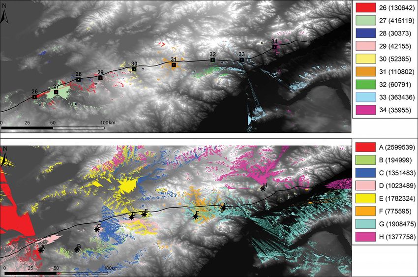
at lower elevations (Figure 9). These data are also supported by a viewshed analysis of
clusters 26–34. Using GIS tools, we compared the areas visible from clusters 26–34
to the areas visible from eight points located close to those clusters, but on higher
ground (Figure 10). The difference is very clear, with each cluster on average ‘seeing’
137 862 pixels of 30 × 30m, while each of the comparison points ‘sees’ an area almost
ten times larger (1 259 007 pixels). Raising the height of the clusters’ viewpoints
by 3m—assuming that people could have used taller buildings for observation—had a
negligible effect on the results.
While the location of clusters at lower elevations could be associated with the position of
local streams, they are more likely to have been associated with roads and paths that
connected areas to the north and south of the wall. This notion is supported by the location
of modern local pathways, many of which cross the wall at, or very near to, the location of
major clusters. Although modern, these routes were not planned or built by the Mongolian
government. Instead, they represent the natural development of travel routes taken by the
local nomadic population. Thus, we argue that they represent ‘logical’ paths probably
taken by nomadic groups since the medieval period. Similar research on the development
of informal road systems in other parts of Mongolia supports this argument (Burentogtokh
2017: 185–86).
© Antiquity Publications Ltd, 2020
11© Antiquity Publications Ltd, 2020
12
Gideon Shelach‐Lavi et al.
Fig. 7 - Colour online, Colour in print
Figure 7. Map of the wall line and a geographic cross-section of it. For a Google Maps version and additional information, see: tinyurl.com/y4hbydw3 (figure by the authors).Fig. 8 - Colour online, Colour in print Medieval long‐wall construction on the Mongolian Steppe during the eleventh to thirteenth centuries AD
Figure 8. Graph of the types and sizes of structures identified along the wall line (figure by the authors).
Fig. 9 - B/W online, B/W in print
Figure 9. Topographic cross-sections showing the location of clusters (numbers) in relation to the topography of their
immediate environment; Y-axis represents elevation above sea level (figure by the authors).
© Antiquity Publications Ltd, 2020
13© Antiquity Publications Ltd, 2020
14
Gideon Shelach‐Lavi et al.
Fig. 10 - Colour online, Colour in print
Figure 10. Viewshed analysis of: top) areas visible from clusters 26–34 (in parentheses are the number of 30 × 30m pixels visible from each cluster); bottom) areas visible from
eight comparison points.Medieval long‐wall construction on the Mongolian Steppe during the eleventh to thirteenth centuries AD
Discussion
Our analysis suggests that the northern wall line was pre-planned and systematically built. Its
location between two mountain ranges, the organised placement of its auxiliary structures
and the combination of different types of structures all suggest a carefully considered design.
We have little doubt that this massive structure facilitated an intended set of functions related
to protecting, observing, monitoring and/or in some way demarcating this northern zone.
We argue, however, that the northern wall line was probably not the fortified border that it
is sometimes considered to represent (e.g. Wang 1921; Jing & Miao 2008; Sun 2010). Both
the Liao and Jin Dynasties, for instance, probably did not conceive of their polity as bounded
by what is the very modern notion of rigid borders. Rather, their view of empire was more
concerned with the control of people, many of them nomads, rather than focused on clearly
defined land borders (Standen 2007). Moreover, while the wall line lies to the west of the
reconstructed borders of the Jin State, it was situated inside Liao territory (Tan 1996).
The construction of the wall across a relatively flat lowland area between two mountain
ranges, and the placing of structures at locations that seem to favour natural pathways through
the wall (as opposed to elevated locations with high visibility), both suggest that the wall system
was intended to control the movement of people, rather than to defend against armies. Further-
more, the detrimental socio-economic impact that frequent cold spells and droughts can have
on the fragile ecology of the Steppe may provide an additional reason for establishing such con-
trol. Known as dzud in Mongolian, their devastating effects on nomadic pastoralist communi-
ties are well documented for historic and modern periods. Between 2000 and 2002 and again in
the winter of 2009, for example, intense cold conditions killed 10.8 and 10.3 million head of
livestock, respectively. In some regions of Mongolia, between 20 and 40 per cent of all livestock
perished during these extreme events, causing the mass migration of herders who had lost their
livelihood to the capital city of Ulaanbaatar (Rao et al. 2015; Sternberg 2016).
Although local occurrences of such climatic events are common, a concentration of extreme
events over a period of 10–20 years can have severe socio-economic impacts, as documented,
for example, in the historic record of the late eleventh and early twelfth centuries (Li et al.
2019). Climatic instability in contemporaneous parts of Asia, known collectively as the Medieval
Climate Anomaly (Stocker et al. 2013), caused large-scale migration events (Ellenblum 2012).
These effects should not be understood as the result of climatic change alone; they must also
be considered in the context of contemporaneous historical and political upheaval. While
small-scale movements of people—potentially associated with sporadic climatically driven hard-
ship—were probably mitigated at the local level, the Liao may have wanted to prevent, or at least
control, larger-scale migrations into the heart of their polity. This hypothesis should be investi-
gated with access to more accurate palaeoclimatic data along with an improved knowledge of con-
temporaneous interactions and political conditions within and beyond this northern zone.
The wall was probably intended to not only control large-scale population movements,
but also movement of different types, such as those related to trade. Thus, the wall could
have functioned to control the movement of both people and commodities out of Liao
territory and into areas inhabited by unaffiliated nomadic communities beyond the polity.
The Liao history, for example, mentions prohibitions on the export of iron materials and
implements to the Huihu (回鶻) and Zubu (阻卜) tribes, which were meant to be enforced
© Antiquity Publications Ltd, 2020
15Gideon Shelach‐Lavi et al.
on the frontiers of the Liao Empire (Wittfogel & Feng 1949: 178). The technological
impacts of these restrictions on local nomadic communities have been recently documented
by archaeological fieldwork in parts of eastern Mongolia (Park et al. 2019b: 96–97).
The wall system described here, and particularly the location of camps associated with
north–south routes, were instrumental in the enforcing of such regulations and inspection
of people travelling to and from Liao territories to those beyond its control. The large rect-
angular enclosures present in all clusters probably acted as base camps for small units that
supervised the closest parts of the wall and associated crossing points. The existence of
such units and their camps are described in the histories of the Khitan-Liao and Jin Dynasties,
as well as in the Western Xia documents (Wittfogel & Feng 1949; Kovalev & Erdenebaatar
2010; Sun 2010; Ma 2013). The absence of visible structures inside most of the enclosures
detected by our fieldwork may suggest that they were not used for long-term habitation,
although this requires verification by future excavations.
The large circular features are found only in the central, flat area of the wall line. While
much larger in area than other structures, their encircling walls are much more diminutive.
These structures could have been used as corrals, perhaps for animals belonging to those who
served along the wall, or for animals either confiscated from nomadic tribes trying to cross the
wall line, or offered as tribute or taxation. Another possibility is that these enclosed areas
represent the locations of border markets described in Liao history (Wittfogel &
Feng 1949: 171). We intend to test these hypotheses in the future using excavation and
geo-archaeological methods (e.g. Shahack-Gross 2011).
Conclusions
A major debate concerning the ‘Great Wall(s)’ of China juxtaposes the traditional view,
which considers walls as defensive structures against the aggression of the nomadic tribes liv-
ing to the north (e.g. Barfield 1989), with a revisionist perspective, which argues that the wall
was part of an imperial expansion that acquired lands previously inhabited by nomadic popu-
lations (Di Cosmo 2002). The research presented here on one episode of East Asian wall-
building tends to support the revisionist model. The location of the northern wall deep inside
the Steppe region suggests that it was not a dividing line between sedentary agricultural and
nomadic pastoralist territories, but rather was located within a region long inhabited by pas-
toral nomadic groups.
Our analysis, however, also suggests a subtle twist to the ‘conquer-and-control’ model.
First, the people who built the wall—either the Liao or the Jin—were themselves part of a
political tradition of creating large-scale ‘nomadic polities’ that had been established on
the Steppe for over a thousand years. Once such polities were founded by nomadic or semi-
nomadic peoples, they tended to adopt and innovate attributes of a sedentary bureaucratic
state, while simultaneously retaining parts of their nomadic identity and legacy (Standen
2007). Thus, we argue that the function of the wall was not to defend against nomadic armies
or raids into sedentary lands, but rather to provide a method for monitoring and controlling
the movement of nomadic populations. A better way to interpret this wall may not be
through the lens of a Chinese-nomadic dichotomy, but rather through a better understand-
ing of the internal dynamics of political society among the nomads and semi-nomads of the
© Antiquity Publications Ltd, 2020
16Medieval long‐wall construction on the Mongolian Steppe during the eleventh to thirteenth centuries AD
Steppe regions. While more archaeological work is needed to test our various hypotheses, the
data and analysis presented in this article are relevant not only to facilitate a better under-
standing of medieval wall systems, but also other episodes of wall-building in Mongolia
and China, and perhaps to other places and periods around the world.
Acknowledgements
This research was supported by funding provided by the Mandel Scholion Research Center,
the Louis Frieberg Chair of East Asian Studies and by the Ring Family Foundation for
Atmospheric and Global Studies, all based at the Hebrew University of Jerusalem. In add-
ition to the authors, field research team members were: Bymbatseren Batdalai, Dashzeveg
Ganbat, Tulgaa Murdorj, Perliilkhunduv Baigalmaa, Nachem Doron, Yotam Toib, Chen
Zeigen, Mika Ullman and Talia Abulafia.
Supplementary material
To view supplementary material for this article, please visit https://doi.org/10.15184/aqy.
2020.51.
References
Baasan, T. 2006. Chingisiin Dalan gezh iuu ve? China, volume 6: alien regimes and border states,
Ulaanbaatar: Admon. 907–1368: 215–320. Cambridge: Cambridge
Barfield, T.J. 1989. The perilous frontier: nomadic University Press.
empires and China. Oxford: Oxford University https://doi.org/10.1017/CHOL9780521243315.
Press. 005
Biran, M. 2007. Chinggis Khan. Oxford: One Franke, H. & D. Twitchett (ed.). 2008. The
World. Cambridge history of China, volume 6: alien regimes
Burentogtokh, J. 2017. Pastoralists, communities and border states, 907–1368. Cambridge:
and monumentality during the Mongolian Bronze Cambridge University Press.
Age. Unpublished PhD dissertation, Yale University. https://doi.org/10.1017/CHOL9780521243315
Chichagov, V.P., O.A. Chichagova, Janz, L., D. Odsuren & D. Bukhchuluun. 2017.
A.E. Cherkinskii & B. Avirmid. 1995. Novye Transitions in palaeoecology and technology:
dannye o vozraste ‘Vala Chingiskhana’. Izvestiia hunter-gatherers and early herders in the
Rossiiskoi akademii nauk, Seriia geograficheskaia 1: Gobi Desert. Journal of World Prehistory 30:
97–106. 1–80.
Di Cosmo, N. 2002. Ancient China and its enemies. https://doi.org/10.1007/s10963-016-9100-5
Cambridge: Cambridge University Press. Jing, A. 2006. Zhongguo Changcheng Shi. Shanghai:
https://doi.org/10.1017/CBO9780511511967 Shanghai Renmin Chubanshe.
Ellenblum, R. 2012. The collapse of the Eastern Jing, A. & T. Miao. 2008. Liao Jin
Mediterranean: climate change and the decline of bianhao yu changcheng. Dongbei Shidi 6:
the East, 950–1072. Cambridge: Cambridge 18–31.
University Press. Kirillov, I. & E. Kovychev. 2002. Kidanskie
https://doi.org/10.1017/CBO9781139151054 drevnosti Priargun’ia. Arkheologiia Dalnauka:
Fitzhugh, W., M. Rossabi & W. Honeychurch 245–52.
(ed.). 2013. Genghis Khan and the Mongol Empire Kiselev, S. 1958. Drevnie goroda Zabaikal’ia.
(2nd edition). Washington, D.C.: Smithsonian Sovetskaia Arkheologiia 4: 107–19.
Institution. Kovalev, A. & D. Erdenebaatar. 2010. About
Franke, H. 2008. The Chin Dynasty, in H. Franke Chinggis Khaan’s wall in Mongolia. Nomadic
& D. Twitchett (ed.) The Cambridge history of Studies 17: 28–33.
© Antiquity Publications Ltd, 2020
17Gideon Shelach‐Lavi et al.
Lattimore, O. 1937. Origins of the Great Wall of identification, and archaeological implications.
China: a frontier concept in theory and practice. Journal of Archaeological Science 38: 205–18.
Geographical Review 27: 529–49. https://doi.org/10.1016/j.jas.2010.09.019
https://doi.org/10.2307/209853 Shelach-Lavi, G., M. Teng, Y. Goldsmith,
– 1963. The geography of Chingis Khan. The I. Wachtel, A. Ovadia, X. Wan & O. Marder.
Geographical Journal 129: 1–7. 2016. Human adaptation and socio-economic
https://doi.org/10.2307/1794892 change in northeast China: results of the Fuxin
Li, Y., G. Shelach-Lavi & R. Ellenblum. 2019. regional survey. Journal of Field Archaeology 41:
Short-term climatic catastrophes and the collapse 467–85.
of the Liao Dynasty (907–1125): the textual https://doi.org/10.1080/00934690.2016.
evidence. Journal of Interdisciplinary History 49: 1194688
591–610. Shiraishi, N. & B. Tsogtbaatar. 2009. A
https://doi.org/10.1162/jinh_a_01339 preliminary report on the Japanese-Mongolian
Lunkov, A., A.V. Kharinskii, N.N. Kradin & joint archaeological excavation at the Avraga site:
E.V. Kovychev. 2011. The frontier fortification the Great Ordu of Chinggis Khan, in
of the Liao Empire in eastern Transbaikalia. The J. Bemmann & E. Pohl (ed.) Current
Silk Road 9: 104–21. archaeological research in Mongolia (Bonn
Ma, Y. 2013. Jin jiehao beixian’ zhi yiyi. The Chinese Contributions to Asian Archaeology 4): 549–62.
Great Wall Museum Journal: 37–43. Bonn: Rheinische
Makino, K. 2007. Typological and chronological Friedrich-Wilhelms-Universität Bonn.
analysis of Khitan-type pottery in the Middle Standen, N. 2007. Unbounded loyalty: frontier
Gobi Desert, Mongolia. Unpublished MA crossings in Liao China. Honolulu: University of
dissertation, Harvard University. Hawai‘i Press.
Park, J., W. Honeychurch & A. Chunag. 2019a. Sternberg, T. 2016. Investigating the presumed
The technological and chronological implication causal links between drought and dzud in
of 14C concentrations in carbon samples extracted Mongolia. Natural Hazards: 1–17.
from Mongolian cast iron artifacts. Radiocarbon https://doi.org/10.1007/s11069-017-2848-9
61: 831–43. Stocker, T.F., D. Qin, G.-K. Plattner,
https://doi.org/10.1017/RDC.2019.4 M. Tignor, S.K. Allen, J. Boschung,
Park, J., W. Honeychurch & A. Chunag 2019b. A. Nauels, Y. Xia, V. Bex & P.M. Midgley.
Novel micro-scale steel-making from molten cast 2013. Climate change 2013: the physical science
iron practised in medieval nomadic communities basis: contribution of Working Group I to the Fifth
of east Mongolia. Archaeometry 61: 83–98. Assessment Report of the Intergovernmental Panel on
https://doi.org/10.1111/arcm.12413 Climate Change. Available at:
Pines, Y. 2018. The earliest ‘Great Wall’? The Long http://www.climatechange2013.org/report
Wall of Qi revisited. Journal of the American (accessed: 12 March 2020).
Oriental Society 138: 743–62. Sun, W. 2010. Jin Changcheng yanjiu
https://doi.org/10.7817/jameroriesoci.138.4.0743 gaishu. Zhongguo bianjiang shidi yanjiu
Ping, Y. 2008. Jin Changcheng de kaogu faxian yu 20(1):139–47.
yanjiu, in W. Sun & Y. Wang (ed.) Jin Sun, W. & Y. Wang (ed.). 2008. Jin Changcheng
Changcheng yanjiu lunji: 88–166. Changchun: yanjiu lunji. Changchun: Jilin wenshi chubanshe.
Jilin wenshi chubanshe. Tan, Q. (ed.). 1996. Zhongguo lishi dituji. Beijing:
Rao, M.P., N.K. Davi, R.D. D’Arrigo, J. Skees, Zhongguo ditu chubanshe.
B. Nachin, C. Leland, B. Lyon, S.-Y. Wang & Waldron, A. 1990. The Great Wall of China: from
O. Byambasuren. 2015. Dzuds, droughts, and history to myth. Cambridge: Cambridge
livestock mortality in Mongolia. Environmental University Press.
Research Letters 10: 074012. Wang, G. 1921. Jin jie haokao. Beijing: Zhonghua
https://doi.org/10.1088/1748-9326/10/7/074012 shuju.
Shahack-Gross, R. 2011. Herbivorous livestock Wittfogel, K.A. & C. Feng. 1949. History of
dung: formation, taphonomy, methods for Chinese society: Liao. New York: Macmillan.
© Antiquity Publications Ltd, 2020
18You can also read