APAN ArcGIS Portal Governance - APAN Community
←
→
Page content transcription
If your browser does not render page correctly, please read the page content below
A “map-centric” content management
 system enabling users to visualize their
         data geographically.

APAN
ArcGIS
Portal
Governance

06/01/2020

                                            1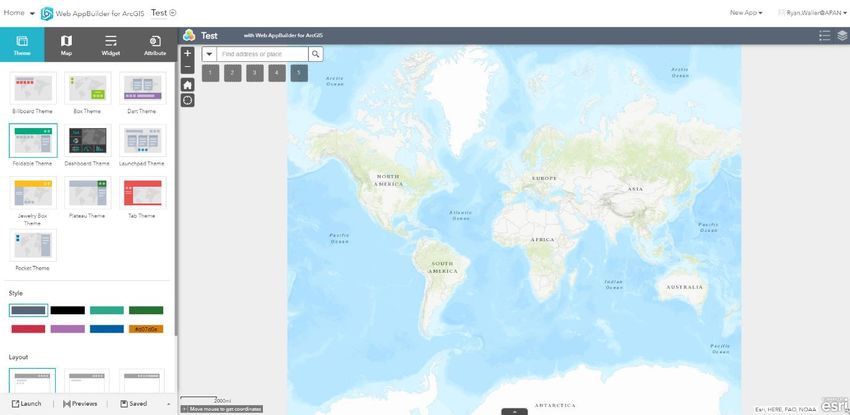
APAN ArcGIS Portal Governance

 APAN ArcGIS Portal Governance                                     Version: 2.1.1

 Author: Karen Volarich / Ryan Waller                              Date: 05/13/2020

 Approval: Tim Mehlhorn                                            Date: 06/01/2020

Document Version

         Version                        Editor              Date                      Comments

1.0                          Karen Volarich      11/13/2018

1.1                          Ryan Waller         11/27/2018

1.2                          Karen Volarich      11/28/2018                   Added graphics and
                                                                              responded regarding
                                                                              Group Manager role

1.3                          Karen Volarich      12/4/2018                    Add size limitations for
                                                                              uploads

1.4                          Ryan Waller         12/6/2018                    Added Roles and
                                                                              Privileges table and
                                                                              removed individual
                                                                              paragraphs for same.
                                                                              Added figures and table
                                                                              numbers. Formatting
                                                                              updated.

1.5                          Ryan Waller         12/12/2018                   Added further info
                                                                              regarding roles. Added
                                                                              process for suspicious
                                                                              users.
1.6                          Karen Volarich      12/13/2018                   Updated Roles &
                                                                              Privileges
1.7                          Ryan Waller         1/23/19                      Added HTML code to
                                                                              Section 7.1
2.0                          Ryan Waller         4/23/20                      Updated Screenshots
                                                                              and data for version
                                                                              10.7.1
2.1                          Karen Volarich      5/7/2020                     Updated content and
                                                                              added screenshots
2..1.1                       Arlana DeLeo        6/1/2020                     Added links to APAN
                                                                              support, Final version
                                                                              approved by Tech
                                                                              Director

                                                                                                   2
APAN ArcGIS Portal Governance

Contents

Document Version........................................................................................................................2
1. Background ...............................................................................................................................5
2. Access ......................................................................................................................................6
   2.1. Inactivity .............................................................................................................................6
   2.2. Suspicious Users ..................................................................................................................6
3. Roles\Permissions....................................................................................................................7
   3.1 Accounts..............................................................................................................................7
   3.2 Roles and Privileges ...............................................................................................................7
   3.3 Data Responsibilities .............................................................................................................9
      4. GIS Data Types & Formats ..................................................................................................9
   4.1 Data Formats – Map Interface ................................................................................................9
   4.2 Data Formats – Content Interface ...........................................................................................9
   4.3 File Size Limitations .............................................................................................................11
   5.1 Web Applications ................................................................................................................14
      5.1.1 Using a Template ..........................................................................................................14
      5.1.2 Using the Web AppBuilder (WAB) ...................................................................................15
      5.1.3 Using Operations Dashboard ..........................................................................................15
   5.2 Sites ..................................................................................................................................16
   5.3 Widgets .............................................................................................................................16
      5.3.1 Built-In Web AppBuilder Widgets ....................................................................................16
      5.3.3.1 Off-panel widgets .......................................................................................................16
      5.3.3.2 In-panel widgets ........................................................................................................17
      5.3.2 Custom Widgets ...........................................................................................................20
   5.4 Products on Demand (PoD) ..................................................................................................21
6. Groups ...................................................................................................................................21
7. Content Sharing Guidelines .....................................................................................................22
   7.1 Controlled Unclassified Information (CUI)...............................................................................22
   7.2 Content Size Limitations.......................................................................................................23

                                                                                                                                          3
APAN ArcGIS Portal Governance

8. Language Support...................................................................................................................24
9. Collaborations ........................................................................................................................25
10. Known Limitations\Issues ....................................................................................................26
   10.1 Web Interface ...................................................................................................................26
   10.2 Desktop Connectivity .........................................................................................................26
   10.3 Mobile Application(s) .........................................................................................................26
   10.4 Single Sign-On (Third party product) ....................................................................................26
11. Upgrades\Patching\Enhancements\Bug Fixes .......................................................................27
   11.1 Upgrades .........................................................................................................................27
   11.2 Patching ...........................................................................................................................27
   11.3 Enhancements ..................................................................................................................27
   11.4 Bug Fixes ..........................................................................................................................27
   Table of Figures: ...................................................................................................................28

                                                                                                                                       4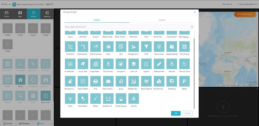
APAN ArcGIS Portal Governance

1. Background
ArcGIS Enterprise is comprised of ArcGIS Server, Portal for ArcGIS and ArcGIS Data Stores (relational, tile, and
spatiotemporal big data). Additionally the following extensions have been deployed: Image Server for processing
and uploading imagery, as well as performing raster analysis; GeoAnalytics Server so users can perform more
robust analytics within Portal, including machine learning; GeoEvent Server which allows for streaming of data in
real-time, such as Twitter feeds, sensor data, and vehicle movements; Maritime Server which gives users access to
maritime charts from within Products on Demand production mapping as well as widgets within web app builder;
LocateXT allows for unstructured data to be geolocated. ArcGIS Enterprise is a one-stop-shop for dynamic
geographic information systems data creation, editing, and spatial analysis.

There are two virtual Windows 2012 R2 web servers setup with failover and load balancing capabilities. Failover is
setup in case one of the two servers goes offline for whatever reason. Load balancing is setup to handle a high-
volume of transactions. Behind the web servers are five virtual Windows 2019 servers, two hosting Portal for
ArcGIS, ArcGIS Server base installation, ArcGIS Data Store (Relational and Tile), LocateXT, and Maritime Server.
These are also setup with failover and load balancing capabilities. The three remaining servers are Windows 2019
OS that host GeoEvent Server with a Spatiotemporal Big Data Store, GeoAnalytics Server using the Spatiotemporal
Data Store, and Image Server.

ArcGIS Data Stores are PostgreSQL databases that are automatically configured upon installation of the software.
Relational data stores are for storing feature layer data. Tile data stores are for storing tile layer data.
Spatiotemporal data stores are for storing “big data” for complex spatial analysis and streaming data. Feature
layers are transactional and are comprised of vector data for editing. Tile layers are images of maps at various
scales, these are primarily used for large, complex polygon data types, such as basemaps. ArcGIS Data Stores are
managed via ArcGIS Server.

ArcGIS Server is the workhorse behind Portal for ArcGIS. These two products are federated and setup with a
hosting server so that users can publish data via Portal that is stored in ArcGIS Server. Portal for ArcGIS has
configuration files that point to the data located within ArcGIS Server. Image Server and GeoAnalytics Server are
also federated for complete integration with Portal.

The current configuration for ArcGIS Enterprise has all software installed on each of the virtual servers, but the
content is stored across AWS S3 buckets and AWS DynamoDB. Scheduled, automated backups of the disk drives
are performed daily.

                                                                                                               5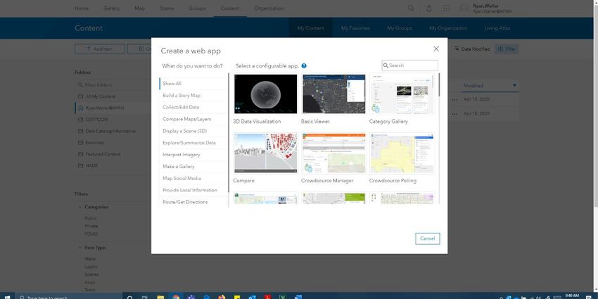
APAN ArcGIS Portal Governance

2. Access
Users can be granted access to ArcGIS Enterprise (Portal) by submitting a request via the Support desk. This will be
routed to either the Product Owner, a KM, or Senior Help Desk Technician for approval and adding the users into
Portal. If none of these people are available, the request should be routed to the System Admin who will
coordinate with the appropriate KM. In addition:

    •   Users must have an existing APAN account to be added to Portal.
    •   New users should be added as any role other than Power Publisher, GIS Product Owner or Administrator.
    •   The Sr. GIS System Administrator is the only Administrator in the system, other than the built-in
        Administrator account used to install the software.
2.1. Inactivity
User accounts will be purged from the system if there has no activity after 90 days. If a user has data, maps, or
applications associated with their account, ownership will be transferred to another user or to the KM associated
with that area of responsibility.

Users who have accounts where they have never logged in, these will be deleted from Portal after not having
logged in after 60 days after creation of user account.

If a user account has been deleted from community.apan.org, it will have been removed or disabled within Active
Directory, thereby rendering the account disabled within Portal as well, even though we may be able to still view
the account existing within Portal. Deletion from community does NOT automatically delete the account from
Portal. Deletion from Portal does NOT automatically delete an account from community.apan.org.

2.2. Suspicious Users
User accounts that appear to be conducting suspicious activities will be reported to the Help Desk for further
action.

                                                                                                                 6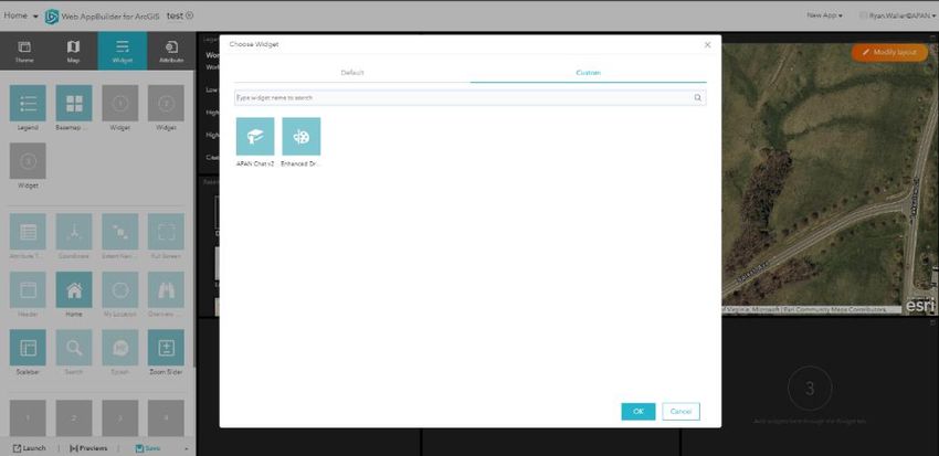
APAN ArcGIS Portal Governance

   3. Roles\Permissions
   3.1 Accounts
   There are two types of accounts within Portal, Creator and Viewer.

         •    Viewer accounts – we have unlimited seats, although it shows 3000. Members of Viewer can view
              content shared with them, but CANNOT create, own, or share content.
         •    Creator accounts – we have 322 seats.. Members can view, create and share content.

   3.2 Roles and Privileges
                                                                                                                      Roles
             Privilege                     Viewer                                                     Creator
                                           Viewer 1   Viewer    User 2   APAN User   Publisher 3     Group           Power      GIS Product   Administrator 5
                                                                          (custom)                 Manager         Publisher      Owner
                                                                                                   (custom)        (custom) 4    (custom)

                                           General Privileges
View & interact with data, maps and apps
             View Members
                                                                NOT TO BE
   Create, Update and Delete groups
       Join Organizational Groups
                                                                  USED
 View Groups Shared with Organization
    Create, update & delete content

   1
     Default role for new users who need viewing rights and for those who are assigned to CUI groups other than the
   Group Manager.
   2
     This role will not be used as the default for any new users. Privileges cannot be edited.
   3
     Prior to be the role being given to a requesting user, the user shall undergo extensive training to ensure compliance
   and understanding of all privileges within the confines of the role – on par with Site Collection Administrator (SCA)
   training in SharePoint.
   4
     This role was created specifically so that KM’s can add users, assign roles, but do not have all Administrative
   privileges. The Administrator role is a System Administrator with the ability to edit systems configurations that can
   lead to the instability of the environment
   5
     Only the Power Publisher and GIS Product Owner roles can change the roles of other users. This is limited to other
   users roles and cannot change their own role or other roles to Administrator

                                                                                                                                      7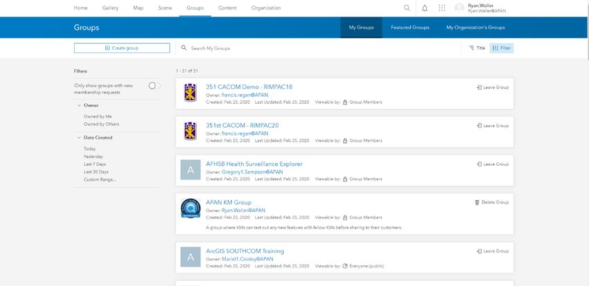
APAN ArcGIS Portal Governance

      Publish Hosted Feature Layers
        Publish hosted tile layers
       Publish hosted scene layers
       Publish server-based layers
 View Content Shared with Organization
 Create feature layers in bulk from a data
                   store
           Register data stores
           View location tracks
        Share content with groups
        Share content with Portal
        Share content with public
      Make groups visible to portal
      Make groups visible to public
           Perform Geocoding
        Perform Network Analysis
    Perform Standard Feature Analysis
     Perform GeoEnrichment Analysis
        Perform Elevation Analysis
  Perform GeoAnalytics Feature Analysis
         Perform Raster Analysis
              Edit Features
      Edit Features with full control
Administrative Privileges
            View All Members
          Update Any Members
           Delete Any Member
              Add Members
          Disable Any Member
     Change the Role of Any Member
     Change from Viewer to Creator
  Manage APAN ESRI Software Licenses
             View All Groups
            Update Any Group
            Delete Any Group
    Reassign Ownership of Any Group
       Assign Members to a Group
 Link Groups to an Enterprise Group (AD)
  Create Groups with Update Capabilities
             View All Content
           Update Any Content
           Delete Any Content
   Reassign Ownership of Any Content
           Manage Categories
            Publish Web Tools
    Security & Infrastructure Settings
          Organization Website

                                                             8
APAN ArcGIS Portal Governance

        Collaborations
        Member Roles
           Servers
        Utility Services
                                             Table 1: Roles and Privileges

3.3 Data Responsibilities
It is the responsibility of the GIS Product Owner and Power Publishers to support the GIS APAN user community
with troubleshooting issues. Many a time this will result in “test” data being created and stored within their “My
Content” section of Portal. Sometimes this data is not “test” and is used by a community member within a map or
an application.

During the last Portal upgrade, it was noted how much data was owned by the GIS Product Owner and Power
Publishers on behalf of the GIS users they support. Moving forward the following rules will be in place for dealing
with this type of data:

    •    “My Content” of the GIS Product Owner and Power Publishers will be reviewed quarterly by the Portal GIS
         Administrator.
             o Dates of review: January 1, April 1, July 1, and October 1 each year
    •    Data that is marked “test”, that is more than 15 days old, will be noted and a message sent to each person
         asking them to review the data.
             o Either the GIS PO or PP will respond that they have deleted the data, or if no response after 3
                  days, the data will be deleted by the Portal GIS Administrator
    •    Data not marked “test”, that is more than 15 days old, will be reviewed by the Portal GIS Administrator to
         gauge it’s use. If deemed it should be owned by another user, the Portal GIS Administrator will notify
         either the GIS PO or PP to change ownership of the content. If no action has been taken after 3 days, the
         Portal GIS Administrator will change the ownership of the data to an appropriate user or if it, in fact,
         appears to be “test” data it will be deleted.

Data created by the GIS Product Owner, Power Publisher or Portal Administrator that needs to be shared across
the Portal APAN Organization or with “Everybody” should be owned by the generic Portal Administrator account,
so that it isn’t tied to a specific person.

4. GIS Data Types & Formats
ArcGIS Enterprise supports a variety of data formats. Depending upon the data format, there may be additional
work performed to have the data display properly on the map or for creating web applications. There are different
data formats supported depending upon whether the data is added via the map interface or via content interface.

4.1 Data Formats – Map Interface
    •    Shapefile – native Esri data format, simple geospatial features, no topology
    •    CSV or TXT files with optional address, place or coordinate locations – must be present to view on the
         map
    •    GPX – GPS exchange format – usually created via Trimble, or other major GPS receivers
    •    GeoJSON – open standard format for simple geographical features
4.2 Data Formats – Content Interface
    •    Add items from your computer

                                                                                                               9
APAN ArcGIS Portal Governance

        o   Upload Shapefiles (zipped) →Publish Hosted Feature Layer
        o   Upload File Geodatabases (zipped) → Publish Hosted Feature Layer
        o   Upload images (png, jpg, etc.) for use as symbols, etc.
        o   Upload CSV or Excel files
        o   Upload KML\KMZ files (KMZ files can be uploaded\downloaded but not viewed in the Map
            Viewer – only KML can be viewed in the Map Viewer. KMZ can be added to map viewer ONLY if
            they are URLs hosted elsewhere).
        o Upload GeoJSON files
        o Upload Service Definition files → Publish Hosted Feature Layer or Tile Layer
•   Add items from the web
        o ArcGIS Server Web Service (must have “map service” in the URL)
        o Add Web Mapping Service (WMS) – Open Geospatial Consortium standard
        o Add Web Mapping Temporal Service (WMTS) – Open Geospatial Consortium standard
        o Add KML
        o Add Web Feature Service (WFS) – Open Geospatial Consortium standard
        o Add Document
        o Create Feature Layer from existing URL - must have “feature service” in the URL
•   Add applications
        o Web Mapping
        o Mobile
        o Desktop
        o Application
        o Application Extension (Operations Dashboard)
        o Application Extension (Web AppBuilder)

                                                                                                 10
APAN ArcGIS Portal Governance
4.3 File Size Limitations
ArcGIS Portal has varying size limitations depending on whether it’s creating new data or uploading attachments to
existing feature layers. The table below details these limits by platform and file type.
Platform File Type Size Limit
Pro\Desktop Raster or File 64 MB
• 360 VR Experience (.3vr)
• AppBuilder Extension (URL)
• AppBuilder widget package (.zip)—Only portal administrators can add this type
of item.
• Application (URL)
• ArcGIS Desktop add-in (.esriaddin)
• ArcGIS Explorer add-in (.eaz)
• ArcGIS Explorer application configuration (.ncfg)
• ArcGIS Explorer document (.nmf)
• ArcGIS Explorer layer (.nmc)
• ArcGIS for Windows Mobile package (.wmpk)
• ArcGIS Pro add-in (.esriaddinx)
• ArcGIS Pro configuration (.proconfigX)
• ArcGlobe document (.3dd)
• ArcMap document (.mxd)
• ArcPad package (.zip)
• ArcReader document (.pmf)
• ArcScene document (.sxd)
• CityEngine web scene (.3ws)
Portal→My Content • Code sample (.zip) 200 GB7
• Comma-separated values (CSV) collection (.zip)
• Comma-separated values (CSV) file (.csv)
• Computer-Aided Design (CAD) drawing (.zip)
• Deep learning package (.zip or .dlpk)
• Desktop application (.zip)
• Desktop application template (.zip)
• Desktop style (.stylx)
• Document link (URL to online document)
• Feature service (URL)
• File geodatabase (.zip)—If you publish a hosted feature layer, only feature
classes (x,y features only), tables, attachments, and relationship classes are
published.
• Geocode service (URL)
• Geodata service (URL)
• GeoJSON file (.geojson or .json)
• Geometry service (URL)
• Geoprocessing package (.gpk)
• Geoprocessing sample (.zip)
• Geoprocessing service (URL)
• Globe service (URL)
7
While Esri has increased the size of upload files from 1GB to 200GB, note that bandwidth issues may impact the
speed to which this is processed.
11APAN ArcGIS Portal Governance
• Image collection (.zip)
• Image file (.jpg, .jpeg, .png, .tif, or .tiff)
• Image service (URL)
• Insights model (JSON)
• Insights Theme (JSON)
• iWork Keys (.zip)
• iWork Numbers (.zip)
• iWork Pages (.zip)
• Keyhole markup language (KML) collection (.zip)
• Keyhole markup language (KML) file (.kml or .kmz) 6
• Layer (.lyrx)
• Layer file (.lyr)
• Layer package (.lpk or .lpkx)
• Layout (.pagx)
• Locator package (.gcpk)
• Map package (.mpk or .mpkx)
• Map service (URL)
• Map service definition (MSD) (.msd)
• Map template (.zip)
• Microsoft Excel file (.xls or .xlsx)
• Microsoft PowerPoint presentation (.ppt or .pptx)
• Microsoft Visio drawing (.vsd)
• Microsoft Word document (.doc or .docx)
• Mobile application (URL)
• Mobile basemap package (.bpk)
• Mobile map package (.mmpk)
• Mobile scene package (.mspk)
• Network analysis service (URL)
• Open Geospatial Consortium (OGC) GeoPackage (.gpkg)
• Open Geospatial Consortium (OGC) Web Feature Service (WFS) (URL)
• Open Geospatial Consortium (OGC) Web Map Service (WMS) (URL)
• Open Geospatial Consortium (OGC) Web Map Tile Service (WMTS) (URL)
• Oriented imagery catalog (.oic)
• Ortho Mapping Project (.json)
• Ortho Mapping Template (.json)
• Portable Document Format (PDF) (.pdf)
• Pro map (.mapx)
• Project package (.ppkx)
• Project template (.aptx)
• Raster function template (.rft.xml or .rft.json)
• Relational database connection (URL)
• Rule package (.rpk)
• Scene layer package (.spk or .slpk)
• Scene service (URL)
• Service definition (SD) (.sd)
• Shapefile (.zip)
6
KML layers larger than 10 MB cannot be added to maps.
12APAN ArcGIS Portal Governance
• Stream service (URL)
• Survey123 add-in (.surveyaddin)
• Tile package (.tpk or .tpkx)
• Vector tile package (.vtpk)
• Web mapping application (URL)
• Workflow Manager service (URL)
• Workflow Manager package (.wpk)
Portal→Map Viewer Web Map 1 GB
Portal→Scene Viewer Web Scene 1 GB
7Z, AIF, AVI, BMP, DOC, DOCX, DOT, ECW, EMF, EPA, GIF, GML, GTAR, GZ, IMG, J2K, JP2,
JPC, JPE, JPEG, JPF, JPG, JSON, MDB, MID, MOV, MP2, MP3, MP4, MPA, MPE, MPEG, MPG,
Attachments 8 10 MB
MPV2, PDF, PNG, PPT, PPTX, PS, PSD, QT, RA, RAM, RAW, RMI, SID, TAR, TGZ, TIF, TIFF,
TXT, VRML, WAV, WMA, WMF, WPS, XLS, XLSX, XLT, XML, and ZIP.
Table 2: File Sizes
8
Attachments can handle larger than 10MB BUT these must be done through the REST API which is only accessible
by the GIS System Administrator
13APAN ArcGIS Portal Governance
5. Web Applications\Sites\Widgets
Portal for ArcGIS provides a variety of functionality for creating applications that can be custom for each
group\community.
5.1 Web Applications
There are three web application creation options built into Portal for ArcGIS, additionally, users can create
applications on their desktop and then upload those to Portal via the “Add Item” menu option.
5.1.1 Using a Template
The templates are pre-loaded with Portal and users are given a list of selections based upon a category. The
category gives a theme and loads default widget options that would most likely be associated with the application.
For example, “Time Aware” loads a web application wizard that includes a time slider widget. The template option
is a wizard that steps the user through building a web application.
Figure 1: Using Templates
14APAN ArcGIS Portal Governance
5.1.2 Using the Web AppBuilder (WAB)
Web AppBuilder is a tool available for creating applications using a wizard builder that takes a user through the
process step-by-step. No coding is required for developing these applications. Like creating data from templates
within Portal for ArcGIS, these applications are hosted within Portal and can be shared (or not) with anyone within
or external to APAN.
Figure 2: Using Web AppBuilder
5.1.3 Using Operations Dashboard
The Operations Dashboard is a web application, derived from a specific template theme. The Operations
Dashboard is a Common Operational Picture (COP) type of application. The concept is a visual overview of the
status of a particular situation or incident used to make decisions during operations. There is usually a map and
several widgets that display gauges of information. For example, in a disaster response, the map would display
where resources were being delivered (such as water) and a widget may display the number of hospital beds
available within a certain radius of the disaster.
Figure 3: Using Web-based Operations Dashboard
15APAN ArcGIS Portal Governance
5.2 Sites
Sites allow users to create custom web sites\pages within Portal without having to do any coding. The concept is
to allow a particular group to be able to create their own site that would deliver a specific message regarding their
content. The displayed information would not necessarily have any information that would lead a user to believe
it was part of APAN. Access to the viewing and building of Sites should be requested by users along with a
justification of what the intent is for the Site.
Figure 4: ArcGIS Sites
5.3 Widgets
Widgets are tools that allow users to perform specific tasks. Portal for ArcGIS has built-in widgets that are
available for use via Templates, Web AppBuilder, or Operations Dashboard. APAN is also able to create custom
widgets and make these available to all users within Portal.
5.3.1 Built-In Web AppBuilder Widgets
Web AppBuilder includes many out-of-the-box widgets. These widgets provide fundamental functions to easily
create web apps. Most of them have parameters that allow configuration and customization. Widgets added from
the Choose Widget window can be set to open automatically when an app starts. In general, widgets are
categorized as two types: off-panel and in-panel.
5.3.3.1 Off-panel widgets
Off-panel widgets are widgets that are not in a panel. They can be turned on or off and can be added to the
controller. The off-panel widgets embedded in a theme display when the Widget tab is activated. The following is a
list of off-panel widgets:
• 3DFx—Provides you with a collection of 3D animation approaches to visualize and analyze geographic
information in an intuitive and interactive 3D environment.
• Attribute table—Displays a tabular view of operational layers' attributes. Currently, layers from a map
service, feature service, and feature collection in the map are supported.
16APAN ArcGIS Portal Governance
• Compass—Click to reorient the scene north.
• Coordinate—Displays coordinates in the current map projection when moving the pointer on the map or
in other coordinate systems by clicking the map.
• Extent Navigate— Allows you to navigate the map to its previous or next extent.
• Full Screen—Enables you to start the app in full screen mode.
• Home Button—Click to zoom to the map's initial extent.
• Incident Analysis—Defines an area of interest and notes what is happening around the area, such as
current weather, demographic information, and features close to the area.
• My Location—Detects your physical location and zooms to it on the map.
• Navigate—Allows you to rotate and pan the scene.
• Overview Map—Shows the current spatial extent of the map display as a gray rectangle relative to the
entire spatial extent of the basemap service.
• Scale bar—Displays a scale bar on the map.
• Search—Replaces the existing Geocoder widget with support for searching and suggestions on multiple
sources.
• Situation Awareness—Allows you to locate an incident on the map and analyze information from different
feature layers within a specified incident area.
• Slides—Shows different views of the scene based on the slides captured in the web scene.
• Splash—Displays content on the splash screen.
• Summary—Dynamically summarizes numeric attributes for features based on the map extent.
• Swipe—Shows a portion of a layer or layers on top of the map.
• Time Slider—Visualizes content within a map that contains time-aware layers.
• Zoom Slider—Provides interactive zoom controls in the map display.
Figure 5: To turn on or off a widget, hover over the widget and click the eye icon.
5.3.3.2 In-panel widgets
In-panel widgets are available to the widget controllers and can be added to your app. By default, they are
contained by a controller. Depending on which theme you choose, they may show in the upper right corner of the
app with the header controller in a Foldable theme or on the left side of the app with the side controller in the Tab
theme.
Each in-panel widget requires user interactions on the panel. The following is a list of in-panel widgets:
• About—Provides information about your app.
• Add Data—Enables end users to add data to the map by searching for layers in ArcGIS Online or ArcGIS
Enterprise content, entering URLs, or uploading local files.
• Analysis—Contains a number of tasks that allow you to perform common spatial analyses on your hosted
data.
• Basemap Gallery—Presents a gallery of basemaps and allows you to select one.
• Batch Attribute Editor—Allows you to select features and update common attributes at once.
17APAN ArcGIS Portal Governance
• Bookmark—Spatial bookmarks for quick navigation.
• Business Analyst—Provides a way to generate Business Analyst Infographics and Classic Reports.
• Chart—Displays charts for selected features.
• Coordinate Conversion—Helps analysts input coordinates and convert them between several common
formats including UTM, Military MGRS, DDM, DMS, DD, and USNG.
• Cost Analysis—Allows you to sketch a proposed design and get an estimated cost of the project.
• Data Aggregation—Creates geographic features from address or coordinate information stored in CSV
files and defines how field information should be correlated between the CSV file and the destination
layer.
• Daylight—Allows you to change how sunlight and shadows affect your scene during different hours and
months.
• Directions—Calculates and displays directions between two or more locations.
• Distance and Direction—Allows you to draw lines, circles, ellipses, and range rings to visualize important
information about places and objects of interest.
• District Lookup—Allows you to find a point feature related to a selected polygon, view detailed
information about the features, and get directions to the selected point feature.
• Draw—Draws basic graphics and text on the map.
• Edit—Provides tools to modify features in editable layers.
• Emergency Response Guide—Allows you to determine potential hazards based on the type of hazardous
material spill and user-selected location on the map.
• Filter— Allows you to limit the visibility of features in a layer.
• GeoLookup—Enriches a list of latitude and longitude points from a CSV file against polygon layers on the
map.
• Geoprocessing—Allows you to use any task from geoprocessing services.
• Grid Overlay—Allows you to quickly render a U.S. Military Grid Reference System (MGRS) grid using client-
side resources.
• Gridded Reference Graphic—Allows an analyst to create grids for use in partitioning geographic areas of
interest.
• Group Filter—Applies a filter on the map based on one or more layers in the map.
• Image Measurement—Allows you to perform measurements on image services with mensuration
capability.
• Info Summary—Provides a count of features contained in the current map extent for each layer specified.
• Infographic—Provides graphic templates to visualize and monitor attribute and statistic data from feature
layers in the map and additional data sources.
• Layer List—Displays a list of operational layers in the app.
• Legend—Displays a legend for the visible layers in the map or scene.
• Measurement—Allows you to measure the area of a polygon, length of a line, or find the coordinates of a
point. In 3D, you can measure horizontal, vertical, and direct distance between two points.
• Near Me—Allows you to find features within a buffer of a defined address or location, view more detailed
information about those features, and get directions to the selected feature.
• Network Trace—Uses a geoprocessing service to trace a geometric network and interact with its results.
For example, a user specifies the location of the main break to generate the outage area.
• Oblique Viewer—Displays images in a native coordinate system using an image coordinate system.
• Parcel Drafter—Enables mapping technicians to enter metes-and-bounds descriptions and check for
closure errors.
• Print—Advanced or basic printing of the current map.
• Public Notification—Allows you to identify a collection of properties and create mailing labels, or a
structured text file, for owners and occupants.
• Query—Query information from operational layers by executing a predefined query.
• Related Table Charts—Allows you to chart (bar, pie, or polar chart) values from a related table of a feature
layer.
18APAN ArcGIS Portal Governance
• Report Feature—Enables you to collect and manage data quality feedback from users.
• Reviewer Dashboard—Displays data quality result statistics as infographics to summarize data quality
issues identified in your GIS data.
• Screening—Allows you to define an area of interest and analyze specified layers for potential impacts.
• Select—Enables you to interactively select features on the map and take the actions on the selected
features.
• Share—Allows you to share an app by posting it to your social media account, sending an email with a
link, or embedding it in a website or blog. It also provides an easy way to define URL parameters for the
app.
• Smart Editor—Extends the Edit widget with more features, such as the ability to perform attribute editing
in the panel instead of in the pop-up.
• Stream—Visualizes and controls real-time data feeds from streaming feature layers.
• Suitability Modeler—Helps you find the best location for an activity and predict susceptibility to risk, or
identify where something is likely to occur.
• Threat Analysis—Supports public safety personnel and first responders to identify safe distances and
zones when planning events, should an incident occur.
• Visibility—Determines what is visible from an observer location based on a given distance, an observer
height, and a field of view.
In addition, in-panel widgets are associated with placeholders that define the position of an in-panel
widget on the screen. You can drag the in-panel widget onto the map when it opens. You can also resize
the panel of the widget by dragging its lower right corner.
Figure 6: To remove the widget, hover over the widget and click the x icon.
19APAN ArcGIS Portal Governance
Figure 7: Built-in Widgets in AppBuilder
5.3.2 Custom Widgets
APAN GIS staff have created and deployed custom widgets that are available to all users. Further custom widgets
can be developed once a requirement is received, vetted and approved for development.
• Chat – Widget that interfaces with APAN chat capabilities for instant messaging. Figure 6, APAN Chat
widget example, shows how the custom widget looks like.
• Enhanced Drawing - Widget that allows for text, points, lines, and polygons to be drawn and exported and
imported for sharing with other users of the created app. Sharing is accomplished either by attaching it to
an existing layer or through other normal file sharing methods.
• Maritime Display Properties – Widget that allows for customizing the display of the Maritime Chart Map
Service. Can only be used with Maritime Chart Services.
• Maritime Identify – Identifies features of the Maritime Chart Service map service. Can only be used with
Maritime Chart Services.
• Maritime Search – Performs a search on Maritime Chart Service features. Can only be used with Maritime
Chart Services.
Figure 9: Custom Widgets in AppBuilder
Figure 8: Custom Widgets
20APAN ArcGIS Portal Governance
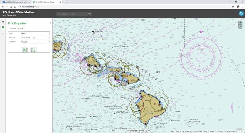
5.4 Products on Demand (PoD)
Products on Demand is an application based upon Maritime Server that comes with the software for deployment.
This product allows for users to generate their own PDF maps of the maritime chart service map service. These
maps can be taken offline for use in low-no bandwidth areas.
Figure 10: Products on Demand: Maritime Server
6. Groups
Groups are collections of items, including data, images, maps and applications that are related to a single topic,
such as an event (hurricane, earthquake, military exercise, etc.).
Groups can be created and managed by designated Group Managers (new role), Publishers, Power Publishers or
Administrators. Any role has permissions to join a group and view its content if the Group Manager permits it.
Group items can be shared publicly or privately, within the organization or within only a group. The only role that
can see everything within portal, including private groups, is the Administrator.
Groups as defined within community.apan.org do not automatically copy over to Portal for ArcGIS, nor does the
content or members within a group. Groups within Portal can be created with the same name as within
community.apan.org or wss.apan.org. The type of content that can be stored within a Group in Portal is different
than what can be stored within in a Group or site in community.apan.org or wss.apan.org. See the GIS Data Types
& Formats section for what can be stored.
For storage of CUI data see the Content Sharing Guidelines in section 7.1.
21APAN ArcGIS Portal Governance
Figure 11: Groups
7. Content Sharing Guidelines
The content permitted within Portal for ArcGIS is subject to the same Terms as the primary APAN community.
These DOs and DON’Ts can be found at https://community.apan.org/p/terms or
https://community.apan.org/p/privacy.
The APAN terms and conditions can be modified at any time without notice.
7.1 Controlled Unclassified Information (CUI)
APAN is approved for storing and sharing CUI according to the approved Authority to Operate (ATO). Further
information on the ATO can be provided by submitting a request via the support ticket process. Information that is
considered CUI includes but is not limited to those items marked as Sensitive But Unclassified (SBU), For Official
Use Only (FOUO) and Official Use Only (OUO). Guidelines for marking and handling of CUI can be found on the
Information Security Oversight Office website under the National Archives here: https://www.archives.gov/cui
Groups that are specially created to store CUI and the other similar handling caveats shall be requested via the
support ticket process. Upon approval from the APAN Technical Director, the designated Group Manager will
undergo training to ensure compliance is maintained at all times.
Groups created in support of the request will remain in a Private Status for the duration of the requested period or
end of event whichever occurs first. Created Groups and its content will be periodically reviewed for required
usage. Any items that are no longer needed to support the requirement shall be deleted by the Group Manager at
the soonest possible time.
Within any new group that is approved to contain CUI, the following line of HTML coding will be inserted in both
the Group Description within Portal and the "About" widget for any Web Applications that are built using the
WebApp Builder in Portal. Worthy of note in this is that it is not "locked for editing". Meaning that APAN staff have
to specifically mention in any training sessions that the Group Owner/Publisher not remove, alter or add to the
code. As a part of training this can be done for the Group Owner/Publisher that will be responsible for the content.
22APAN ArcGIS Portal Governance
Highest
Classification Possible UNCLASSIFIED\\FOUO
Within any web applications that are created APAN shall use the "About" widget as a header across the top of the
application renaming the widget to "NOTICE:"
Information that will not be approved for storage/use in APAN or ArcGIS Portal includes Protected Health
Information (PHI) covered under the Health Insurance Portability and Accountability Act (HIPAA) more information
on what is considered PHI can be found here: https://www.hhs.gov/hipaa/for-professionals/security/laws-
regulations/index.html.
7.2 Content Size Limitations
See Section 4.3 for information regarding size limitations for uploading content.
23APAN ArcGIS Portal Governance
8. Language Support
Portal for ArcGIS at 10.7.1 supports thirty-eight (38) languages out-of-the-box. Users have the ability to modify
their default language by editing their profile information. Once logged in, the user will see their name in the top
right of the page next to the search box. Click on the arrow next to the name and select “My Profile”. Click “EDIT
MY PROFILE”. There is a language drop-down box where the user can select the default language for their
account.
Note: This changes the language of the interface ONLY. Data that has been published in a specific language will
NOT be translated to a different language. For example, if I change my default language to French, but data that I
need to work with has been published in English, it will remain in English while the interface and descriptors of the
data (i.e. metadata) will be in French.
Note – the translate function available via community is NOT available within Portal, nor will it be made available
for the foreseeable future.
The following languages are available out-of-the-box:
• Arabic • Serbian
• Bosnian • Simplified Chinese
• Catalan • Slovenian
• Croatian • Spanish
• Czech • Swedish
• Danish • Thai
• Dutch • Traditional Chinese (Hong Kong)
• English • Traditional Chinese (Taiwan)
• Estonian • Turkish
• Finnish • Ukrainian
• French • Vietnamese
• Greek
• German
• Greek
• Hebrew
• Hindi
• Indonesian – Bahasa Indonesia
• Italian
• Japanese
• Korean
• Latvian
• Lithuanian
• Norwegian
• Polish
• Portuguese (Brazil)
• Portuguese (Portugal)
• Romanian
• Russian
24APAN ArcGIS Portal Governance
9. Collaborations
Collaborations – or Distributed Collaborations – are a mechanism for enabling sharing of content between entities.
These entities can be individuals, businesses, communities, or in APAN’s case, other governmental agencies or
NGOs.
Collaborations are established from Portal-to-Portal, between multiple Portals or from Portal-to-ArcGIS Online.
Collaborations can be structured so that only specific content can be viewed, created, edited or shared.
Only Administrators can create a collaboration through the system administration interface.
KM’s can either initiate or facilitate the establishment of collaborations through Memos of Understanding (MOU’s)
between designated Government representatives and the APAN Technical Director in accordance with APAN
policies for data sharing.
Once the Administrator has received an approved Collaboration request from the APAN Technical Director, these
will be established.
Once a Collaboration is deemed no longer viable, it will be removed.
Figure 12: Collaborations
25APAN ArcGIS Portal Governance
10. Known Limitations\Issues
This is a living document, the list of known limitations\issues will updated periodically, as new issues come to be
known.
10.1 Web Interface
Currently no known issues.
10.2 Desktop Connectivity
Unable to login to Portal for ArcGIS via ArcGIS Pro or ArcMap\ArcGIS Desktop due to the Single Sign On limitation
below, and therefore unable to published hosted map\feature services.
10.3 Mobile Application(s)
Currently no known issues.
10.4 Single Sign-On (Third party product)
Portal currently uses the APAN customized Passport\CAMS product for Single Sign On capabilities, this forces the
sign-on page within Portal to redirect to passport.apan.org prior to entry into the Portal site. This impacts mobile
and desktop applications from properly interfacing with Portal. APAN is currently researching SAML 2.0
replacements.
26APAN ArcGIS Portal Governance
11. Upgrades\Patching\Enhancements\Bug Fixes
Periodically there will be modifications to the infrastructure. These will be done within outage windows and with
proper notification to the user community.
11.1 Upgrades
Minor releases of the Esri ArcGIS Enterprise product line are released once a year, usually in July around the time
of their annual user conference.
Major releases of the Esri ArcGIS Enterprise product line are released every few years.
Upgrades to the APAN ArcGIS Enterprise infrastructure will follow a Development→Staging→Production
deployment cycle – testing all content and functionality along the way to ensure there are no major negative
impacts to the user community. New features of the product(s) will be documented, and information
disseminated to the user community.
11.2 Patching
Operating System patching occurs monthly, and usually requires a reboot of the system.
ArcGIS Enterprise product patching happens periodically through the year. Research into the impacts of these
patches are done prior to implementation. System reboots and outages can occur with these patches, and
therefore will only be deployed during authorized APAN outages.
11.3 Enhancements
New products with the ArcGIS Enterprise line of products will be integrated into the current infrastructure during
any year. As these occur, information of the features available to the user community will be disseminated.
Users who have a request for an enhancement of the Portal for ArcGIS may submit a support ticket via
https://community.apan.org/support/p/contact . These will be reviewed by the KM’s, Product Owner, GIS Systems
Administrator and Developer to gauge need, feasibility and level of effort to implement. Depending on the level of
effort for the requirement, it may require an email and/or Memorandum for Record to the APAN Technical
Director from the Requestor’s Government Point of Contact and/or an input into the CJCSI 6285.01 process for
official validation and routing.
11.4 Bug Fixes
Any user that finds an issue with Portal for ArcGIS may submit a support ticket for assistance at
https://community.apan.org/support/p/contact or email support@mpe.apan.org with screenshots/attachments.
Details of the issue and contact information are required in order to re-create the issue and either step the user
through the issue or note a bug for fixing.
Bug fixes may be out of the realm of APAN Developers and\or GIS Systems Administrators to fix, since the issue
may lie in the software product itself. Staff will submit the bug issue to Esri.
Bug fixes will be deployed during APAN outages for patching or upgrades.
27APAN ArcGIS Portal Governance
Table of Figures:
Figure 1: Using Templates.............................................................................................................14
Figure 2: Using Web AppBuilder ....................................................................................................15
Figure 3: Using Web-based Operations Dashboard ..........................................................................15
Figure 4: ArcGIS Sites ...................................................................................................................16
Figure 5: To turn on or off a widget, hover over the widget and click the eye icon. ..............................17
Figure 6: To remove the widget, hover over the widget and click the x icon........................................19
Figure 7: Built-in Widgets in AppBuilder .........................................................................................20
Figure 8: Custom Widgets .............................................................................................................20
Figure 9: Custom Widgets in AppBuilder .........................................................................................20
Figure 10: Products on Demand: Maritime Server ...........................................................................21
Figure 11: Groups ........................................................................................................................22
Figure 12: Collaborations ..............................................................................................................25
28You can also read