USGS Update Kevin T. Gallagher Associate Director, Core Science Systems April 8, 2021 - MAPPS
←
→
Page content transcription
If your browser does not render page correctly, please read the page content below
+

USGS Update

              Kevin T. Gallagher
              Associate Director, Core Science Systems
              April 8, 2021
+                                                                  2
    Agenda
    USGS activities – Kevin Gallagher
    ◼   Priorities of the new Administration
    ◼   National Land Imaging (NLI) update
    ◼   3D National Topography Model (3DNTM) overview

    3DNTM components
    ◼   3DNTM governance and planning – Vicki Lukas
    ◼   Technologies for the next generation 3DEP – Jason Stoker
    ◼   Inland bathymetry update – Cindy Thatcher
    ◼   Current and future data acquisition – Sue Buto
    ◼   Preview of the 3D Hydrography Program – Becci Anderson

    Q&A and DISCUSSION – ALL
+                                                                                                                                  3
    Department of the Interior Priorities (slide 1 of 4)
    Foundational data and science underpin DOI and Administration priorities
    ◼   Conservation - multiuse land management, wildlife and habitat management, wetlands
        inventory and mapping, water resource management, and coastal zone management, biological
        carbon stocks assessment
    ◼   Climate Science – flooding, wildfire prediction, water quality and quantity, drought, and sea level
        rise and subsidence
    ◼   Clean Energy Deployment – solar, wind and
        geothermal power; calculating range for electric
        vehicles

                                                                “The US Global Change Research Program identified
                                                                Landsat as a critical observatory for climate and
                                                                environmental change research due to the unbroken length
                                                                of the Landsat record and its ability to monitor remote
                                                                regions with surface features such as glaciers, rainforests,
                                                                permafrost, and coral reefs.”
                                                                -CRS Report on L9 and the Future of the Sustainable Land Imaging Program
+                                                                              4
    Department of the Interior Priorities (slide 2 of 4)
    Foundational data and science underpin DOI and Administration priorities
    Infrastructure
    ◼   3DEP, NHD, and geophysical data are
        foundational and directly applicable to a broad
        range of infrastructure applications
    ◼   Data acquired have a high ROI for infrastructure
        as well as a broad range of other applications
    ◼   Data are acquired by the private sector, creating
        jobs
    ◼   Data programs are “shovel ready”
    ◼   The Federal and industry capacity exist to
        execute and deliver
    ◼   Data acquisition is easily accounted for and
        auditable
    ◼   No new O&M tail is required
    ◼   We have shown success before with ARRA – a
        proven process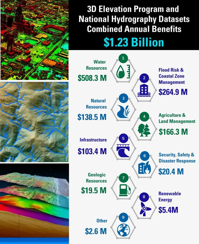
+                                                                                                      5
    Department of the Interior Priorities (slide 3 of 4)
    Foundational data and science underpin DOI and Administration priorities
    ◼   Reclamation Jobs Program:
        applications to map and transform
        orphan oil and gas well infrastructure
        and abandoned mine lands, and
        transition away from coal production
    ◼   Economy - data are acquired and
        value-added by the private sector,
        creating jobs and fueling user
        industries
    ◼   Tribal Programs – natural resources      Klamath, Kootenai, and Nisqually Tribes: using
                                                 bathymetric lidar data for fish habitat restoration
        management, infrastructure
        development and maintenance,
        cultural resource preservation,          Nez Perce Tribe: using lidar data to
        climate science                          assess hazards including post-fire
                                                 landslides, debris flows, and floods,
                                                 and to assess ecosystem restoration in
                                                 disturbed areas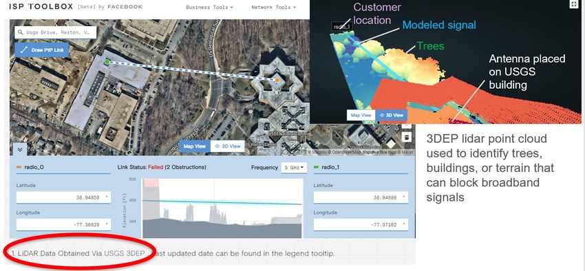
+                                                                                6
    Department of the Interior Priorities (slide 4 of 4)
    Foundational data and science underpin DOI and Administration priorities
    ◼   Racial and Economic Equity
        ◼   Applications for          Facebook Line of Sight Tool- ISP Toolbox
            flooding and other
            hazards that
            disproportionately
            affect underserved
            communities
        ◼   3DEP data can help
            improve maps of
            broadband accessibility
            to help address the
            digital divide for
            students in rural and
            underserved
            communities, even in
            urban areas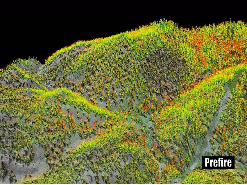
USGS National Land Imaging (NLI) Program Future Directions (Slide 1 of 3)
Leveraging the diversity of Earth Observations to meet the Diverse Needs of Science & Operational Users
NLI Program Goals
Improve Operational Capabilities
Enhance Research, Development and Innovation
2028
Expand Product and Service Usability Landsat Next
2023
Ensure Community Engagement
Cross-Calibration of Sensors
Hyperspectral Technology Investigations
International & Commercial Partnerships
2021
Landsat 9
2019
Sentinel/Landsat Ops & Data Harmonization
Investigate new science and technologies
2018
National Security Space Data & Services
Land Change Monitoring Assessment and Projection / EarthMAP
2016
Analysis Ready Data
Thoroughly understand user needs and capabilities available to meet them
2013
Landsat 8 Flight & Ground Operations
7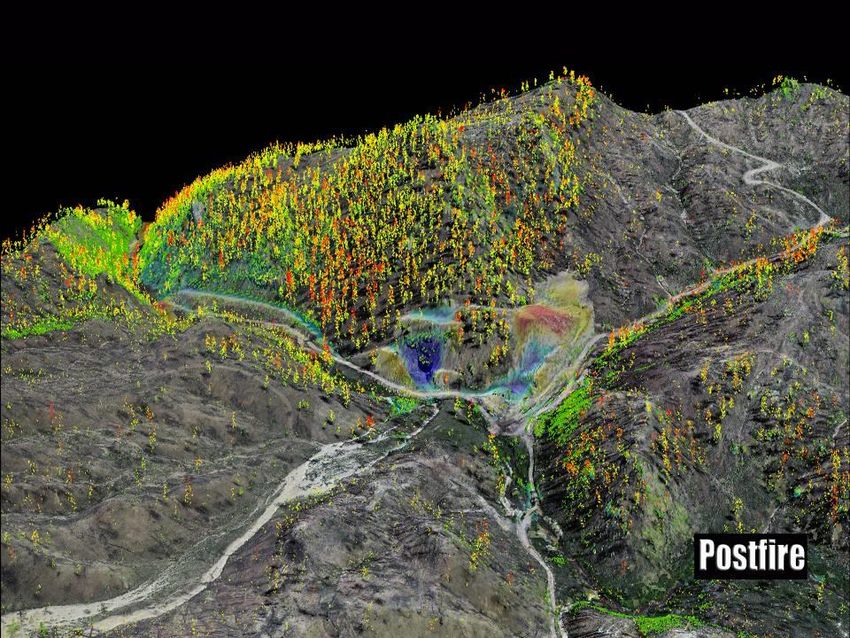
Landsat Operations and Development Status (Slide 2 of 3)
Active
In Development
Landsat 9 Landsat Next
Planned (Launch in 2021) (~ late 2020s launch)
Landsat 8 Flight Copy of Landsat 8, but with Technology and user needs
Operations important improvements for analyses led to an architecture
accuracy and resiliency (upgrade
(2013- ) to fully Risk Class B); 14-bit data.
study, which delivered post-
Landsat 9 recommendations to
Collecting up to 740 new NASA and USGS in 2020.
scenes per day; frequent night
and off-nadir imaging of volcano NASA and DOI/USGS working
and fire imaging. together to define a multi-
component architecture; details to
be announced with FY22 Budget.
Landsat 7 Flight
Operations Landsat Archive Operations
(1999- )
Over 9 million unique Landsat scenes available in the 50-
Collecting about 470 new scenes per year archive, with over 100 million downloads since
day; latest fuel estimate projects Landsat data become freely available in 2008.
operations through 2021. New “Collection 2” now available on the Amazon Cloud. 8
8
9
Landsat’s Relevance in the Era of Commercial Earth Observation Satellites
(Slide 3 of 3)
Rapidly growing commercial space industry is expanding the
number of available Earth observation satellite systems
➢ Focused on high resolution (5 meters or less) visible, near-infrared surface imaging
➢ Constellations of frequently launched CubeSats that provide near daily coverage
While these commercial capabilities fulfill an observational need, Land Remote
they do not possess the ability to replicate Landsat’s capabilities, Sensing
Satellites
due to size, weight and power considerations Launched per
➢ More limited measurement capability (no shortwave or thermal infrared capability) Year
➢ Unable to achieve reference calibration standards pioneered by Landsat for decades
The Landsat global survey mission remains unique among U.S.
federated and commercial Earth observation missions
➢ Long term, traceable calibrated science data adhering to NIST and FGDC standards
➢ Consistent highly-calibrated data covers the entire globe, regardless of commercial value
➢ Commercial satellite systems continue to rely on Landsat as a calibration reference
Commercial Government
9
(Slide 1 of 3)

3DNTM:
+      Next Generation of Integrated Data                                                                                       10
Topography is defined by elevation and hydrography; elevation shapes hydrography, and hydrography shapes
elevation. To support a broad range of applications, the 3D National Topography Model integrates USGS
elevation and hydrography datasets to model the Nation's topography in 3D.

                                                                       Next Generation NHD: 3D Hydrography Program
                                                                       (3DHP)
                                                                          ◼   Operationalize deriving hydrography from lidar/IfSAR
                                                                          ◼   Enable better accounting of the hydrologic cycle by adding
                                                                              connections to groundwater, engineered hydrologic
                                                                              systems and wetlands
                                                                          ◼   Fully implement the National Hydrography Infrastructure
                                                                              as the universal mechanism for sharing and discovering
                                                                              water information

                                                                       Next Generation 3D Elevation Program (3DEP)
                                                                          ◼   Operationalize inland bathymetry
                                                                          ◼   Collect new data based on landscape change, evolving
                                                                              user needs and technology, vegetation structure
                                                                          ◼   Enable monitoring and change detection by comparing
                                                                              baseline with new vintages of data
(Slide 2 of 3)
3DNTM:
+ Next Generation of Integrated Data 11
Topography is defined by elevation and hydrography; elevation shapes hydrography, and hydrography shapes
elevation. To support a broad range of applications, the 3D National Topography Model integrates USGS
elevation and hydrography datasets to model the Nation's topography in 3D.
Future Integration
◼ Research and develop a 3D data model to fully integrate 3D
Hydrography Program (3DHP) and 3D Elevation Program (3DEP)
◼ Integrate other data from The National Map
◼ Research activities
◼ 3D representation models and 3D volumetric mapping to include
subsurface and atmospheric components
◼ Data model organization techniques to effectively support “change
over time” analysis
◼ 3D visualization of TNM layers - 3D Topo, street view, and 3D features
like overpasses, bridges, tunnels, etc.
◼ Technologies and knowledge graphs to enable integration of TNM
layers in near real time
◼ Generalization and multi-scale mapping techniques that preserve
important terrain features attributes, such as surface water, landforms,
and infrastructure across scales
◼ High-performance computing, artificial intelligence, and machine
learning techniques to handle large data volume analysis and feature
extraction(Slide 3 of 3)
3DNTM:
+ Supports the Nation’s Critical Applications 12
z
Topography is defined by elevation and hydrography; elevation shapes hydrography, and hydrography shapes
elevation. To support a broad range of applications, the 3D National Topography Model integrates USGS
elevation and hydrography datasets to model the Nation's topography in 3D.
▪ Delivers the terrestrial component of
the 3D Nation vision of a continuous
data surface from the depths of the ▪ Provides universal discovery and sharing
oceans to the peaks of the mountains of water information as the geospatial
foundation for the Internet of Water
▪ Enables new and emerging applications
▪ Provides foundational data to critical initiatives
▪ Multiple vintages enable change
▪ FEMA Future of Flood Risk Data and Risk detection
Rating 2.0
▪ Water-related applications move
▪ The National Water Model from the neighborhood to the street-
▪ The Clean Water Act level in accuracy
▪ National Landslides Preparedness Act
▪ Underpins a broad range of applications
including flood risk management, hazards
response and mitigation, infrastructure
management, climate change science, and more+
3DNTM:
Governance and
Planning
Vicki Lukas
MAPPS Conference
April 8, 2021+ 14
3D Elevation Program (3DEP)
Governance
■ USGS and NOAA co-lead the OMB A-16 Elevation Theme Member Agencies
■ 3DEP Executive Forum Bureau of Land Management
Department of Homeland Security
■ Facilitates executive collaboration on strategies to fund and implement 3DEP
Department of Transportation
for the benefit of all its stakeholders
Environmental Protection Agency
◼ Executive Outreach to Industry Partners and Stakeholder Groups Federal Aviation Administration
Federal Communications Commission
■ Provides direction to 3DEP Working Group
Federal Emergency Management Agency
■ 3DEP Working Group - Coordinates implementation of 3DEP US Forest Service
US Fish and Wildlife Service
National Oceanic and Atmospheric Administration
National Park Service
Natural Resources Conservation Service
Office of Surface Mining Reclamation and Enforcement
US Department of Agriculture
US Army Corps of Engineers
US Geological Survey
American Association of State Geologists
National States Geographic Information Council+ 15
National Landslides Preparedness Act (P.L. 116-323)
Authorizes the 3D Elevation Program and Establishes Governance
◼ Establishes a 3DEP Federal Interagency Coordinating Committee, chaired by the Secretary of the Interior
in coordination with the Secretary of Commerce and the Secretary of Homeland Security including:
◼ Agriculture
◼ Commerce
◼ Homeland Security
◼ National Science Foundation
◼ Office of Science and Technology Policy
◼ Office of Management and Budget
◼ The head of any other Federal department or agency, at the request of the Secretary
◼ Within a year, the coordinating committee will develop a strategic plan and a management plan to implement the
strategic plan
◼ Creates a subcommittee of the National Geospatial Advisory Committee, an entity authorized under the National
Geospatial Data Act of 2018 (P.L. 115-307), to advise the 3D elevation program interagency coordinating
committee
◼ Not later than 1 year after the date of enactment, and every 2 years thereafter, the advisory committee will provide a report
to the coordinating committee with recommendations for implementing and advancing 3DEP+ 16
National Landslides Preparedness Act (P.L. 116-323)
Goals for 3DEP FICC and NGAC Subcommittee
◼ Merge/evolve 3DEP Executive Forum with/to the FICC so there is only one executive committee; ensure that the 3DEP
Working Group is linked to the FICC
◼ Evolve towards broader coordination for the future direction of the 3D National Topography Model (3DNTM), and
eventually including both elevation and hydrography (Waters Inland and the National Hydrography Infrastructure
Working Group)
◼ Encourage engagement at highest levels of DOI, DHS and DOC and listed agencies; invite new agencies to participate
◼ Potential topics for both groups
◼ Funding
◼ What creative funding options should we be looking at to complete nationwide coverage?
◼ How can we complete Federal lands where the agencies do not have 3DEP funding?
◼ Delivery/distribution
◼ How can we improve our delivery/distribution?
◼ What new products or pre-processed information should we be offering?
◼ Future directions
◼ Input on the 3D National Topography Model
◼ Recommendations on research and future implementation of the 3D data model
◼ Best practices for 3DNTM partnerships and governance+ 17
3DNTM Development
Lessons Learned from 3DEP+ 18
3DNTM Development = COMPLETE = IN PROGRESS
3D Hydrography Program - Status+ 19
3DNTM Development = EXISTING SYSTEMS
as a starting point
= IN PROGRESS
Next Generation of 3DEP - Status+ 20
Combined benefits
of current programs+ 21
3DNTM:
Technologies for the next
generation 3DEP
Jason Stoker
USGS National Geospatial ProgramThe future of 3DEP after baseline completion ■ After a once over baseline using lidar, the question becomes: What’s next? ■ 3D National Topography Model helps chart future course for our mission ■ 3D Nation Study helps define future requirements ■ Focus can now shift to targeting updates and going from mapping to monitoring ■ Not limited by first goal- seamless, consistent national dataset
The future of 3DEP is
               Changing
+ 25
Different Sensors, different changes
■ Using different types of sensors
allow for detecting different levels
of change
■ Extend historical records of 3D
Change
■ Cost-effective solutions for
tipping/cueing
■ We will begin investigating optimal
solutions based on 3D Nation
requirements and (hopefully) an
interdisciplinary USGS WG
Courtesy of Dean Gesch, USGSThe future of 3DEP is
Uncertain(ty)+ 27
Our future is Uncertain(ty)
■ Uncertainty will become a
key component in future
3DEP data management
scheme
■ Instead of ‘best available’
equating with simply the newest
project, we want to offer the
ability to include uncertainty as
an attribute in decision makingOur future is Uncertain(ty)
■ Every sensor, dataset, or
project has some level of
uncertainty
■ Knowing per point or per pixel
uncertainties will allow for
appropriate data integration
■ Uncertainty knowledge will be
critical for doing correct
change detection
Points scaled by UncertaintyThe future of 3DEP is
Multi-modal+ 30
Our future is multi-modal
Higher Lower
Satellite-based
Density and Accuracy
Areal Coverage
Airborne-based
UAS-based
Lower Higher
Ground-based surveys+ 31
Our future is multi-modalOur future is multi-modal
■ Needed transparent, repeatable
methodology to assess new
modalities can be used for 3DEP
■ Defined “Operational Readiness
Levels (ORLs)” to foster incubation
and development for operational
use
■ Specifications will
continue to
adapt to changing technologies
https://pubs.usgs.gov/of/2020/1015/ofr20201015.pdfOur future is multi-modal Investigating utility of other sensor types via several mechanisms: ➢ 3D Nation Study- requirements ➢ NASA Surface Topography and Vegetation Study Team ➢ Commercial technology assessment (Aerospace Corp)
Our future is multi-modal
Investigating utility of other sensor types
via several mechanisms:
 ➢ Cooperative Research and
  Development Agreement with Sceye for
  stratospheric lidar incubation
 ➢ Researching utility of mobile lidar (e.g.
  HERE Technologies)
 ➢ Working with NGA on DSMs from
  satellite stereo imagery using Rosetta
  Platform
 ➢ Investigation of dual NAIP-3DEP sensor
The future of 3DEP is
            Complicated
Everything in its right place
Satellite
altimetry
SfM
Radar
Acoustic
Sonar
Bathymetric
UAS lidar
lidar
Mobile
lidarWhat we want to avoid
https://jalopnik.com/worst-car-on-craigslist-gallery-5920488Piecing together can be cool!
https://madmax.fandom.com/wiki/The_Gigahorse+
3DNTM:
Inland Bathymetry Update
Cindy Thatcher3DNTM
+ Development Tracks 40
Topography is defined by elevation and hydrography; elevation shapes hydrography, and hydrography shapes
elevation. To support a broad range of applications, the 3D National Topography Model integrates USGS
elevation and hydrography datasets to model the Nation's topography in 3D.
Next Generation 3D Elevation Program (3DEP) Klamath River, CA
◼ Operationalize inland bathymetry
◼ Collect new data based on landscape change, evolving user
needs and technology, vegetation structure
◼ Enable monitoring and change detection by comparing baseline
with new vintages of data
Goal: Extend the 3DEP elevation surface under
Klamath
waterbodies with inland bathymetry to replace
River, CA
estimated flow volume with volume calculated
Potomac River, VA/MD/WV
from the mapped surface41
+ 41
Inland Bathymetry Pilot Projects
Strategy to use pilot projects to
inform
▪ Topo-bathy lidar collection criteria
▪ Development of specifications
▪ Collaborating on an effort led by USACE
JALBTCX and NOAA to develop
bathymetric lidar specifications
▪ Process to operationalize inland bathy
▪ Data validation and publishing methods Klamath River, CA/OR
▪ Research on accuracy, influence of
water clarity on bottom detection, and
lidar processing techniques at EROS
Klamath River Kootenai River, ID: bathymetry lidar shown in blue/purple, and topo lidar shown
in grayscale.+ 42
Inland Bathymetry for 3DEP
Growing interest in bathymetric lidar for:
▪ Fish habitat restoration ▪ Dam removal science
▪ Flood modeling ▪ Sediment transport modeling
▪ Drinking water protection
Kootenai River, ID Klamath River, CA/OR Potomac River, MD/VA
Klamath River, CA
Niobrara
River, NE
Image: Quantum Spatial Inc.43
+ 43
Bathymetry Data Integration
Integrated topobathy models combine topo lidar, bathy lidar, and
sonar into a single digital elevation model.
Klamath
River,
CA/OR
Bathymetric lidar point cloud (topo Multibeam echosounder sonar Sonar data fills data gaps in areas
and bathy points) data with deep pools or riffles River
PotomacBathymetric lidar
44
+ 44
Inland Bathymetry
3D Nation Study PRELIMINARY Information
Source of approx. 500 mission critical activities that
identified the need for inland bathymetry
State or U.S. Territorial government 43%
Federal Agencies and Commissions 31%
Regional, County, City, or other local government 11%
Academic or Not-for-Profit 10% The National Map Advanced Viewer
Private or Commercial 5%
Tribal government 1%
Klamath River, CA/OR
CoNED integrated
topobathy models.
Bathymetric lidar
Potomac River
CoNED topobathy models+ 45
Klamath Science Applications
■ USGS Water Mission Area: Currently using the Figure from Jenny Curtis, USGS
data to map the topography of small side
channels for shallow water juvenile fish habitat
■ Yurok Tribe: Restoring salmon habitat and
understanding the effects of planned dam
removal on fisheries
■ NOAA Marine Fisheries: Salmon habitat
restoration and recovery; estuarine habitat
monitoringBathymetric lidar
+ Bathymetric Data on TNM 46
Completed & Planned Surveys
The National Map Advanced Viewer
Bathymetric lidar
CoNED topobathy models
Integrated topobathy model+
3DNTM: Current and
Future Data Acquisition
Susan Buto
National Hydrography Data Acquisition Lead
Acting 3DEP Data Acquisition Lead+ 48
+ 3DEP Goal 50
Data available or in progress for ~78% of the Nation at the end of FY20
*includes lidar and AK IfSAR
◼ Provide the first-ever national baseline of
consistent high-resolution topographic
elevation data – both bare earth and 3D point
clouds – collected in a timeframe of less than
a decade
◼ Goal to complete by 2023
◼ At the end of FY20 78% of the Nation had
3DEP-quality data available or in progress
Data acquisition investments by all partners, by fiscal year+
Over 300 3DEP partners including 18 Federal agencies and >250 state and local governments
Bureau of Indian Affairs CA Geological Survey Marion County GIS, IN Sarpy County, NE AIken County, SC Mohave County, UT
51
Bureau of Land Management CA Natural Resource Agency Hamilton County, IN NH Department of Environmental Services Anderson County, SC Bear Lake Watch
DOD - AZ National Guard CalFire Wayne County, IN NH Department of Transportation Beaufort County, SC City of Tremonton, UT
Department of Energy City of San Diego OHS, CA KS Department of Agriculture NJ Department of Environmental Charleston County, SC City of Logan, UT
Federal Emergency Management Los Angeles Regional Imagery KS GIS Policy Board Protection City of Aiken, SC City of Brigham, UT
Agency Consortium, CA KY Commonwealth Office of DE Valley Regional Planning City of Greenville, SC Fairfax County, VA
Fish and Wildlife Service San Diego County, CA Technology Commission City of North Augusta, SC Henrico County, VA
National Geospatial-Intelligence San Diego Association of KY Division of Water City of Henderson, NV Dorchester County, SC University of Virginia
Agency Governments, CA LA Coastal Protection and City of Las Vegas, NV Jasper County, SC VA Dept of Environmental Quality
National Oceanic and Atmospheric Southwest Wetlands Interpretive Association Restoration Authority Clark County Regional Flood, NV Lexington County, SC VA Information Technologies
Agency City of Montrose, CO LA Department of Transportation Clark County Water Reclamation Newberry County, SC Agency
National Park Service CO Division of Rec and Mining and Development District, NV Pickens County, SC City of Williamsburg, VA
Natural Resources Conservation CO Governor's Office of Arlington, MA Clark County, NV Richland County, SC VT Agency of Commerce and
Service Information Technology State of MA Lyon County, NV SCANA Public Utility, SC Community Development
Tennessee Valley Authority CO Water Conservation Board MassGIS Southern NV Water Authority South Carolina Lidar Consortium Columbia County
U.S. Navy Denver International Airport Baxter State Park, ME Storey County, NV 911, TN WA Dept of Natural Resources
US Army Corps of Engineers Garfield County, CO Bureau of Parks and Lands, ME University of Nevada Reno Appalachian Electric Co-op, TN Adams County, WI
US Bureau of Reclamation Gunnison County, CO Clayton Lake Woodland Holdings, LLC Washoe County, NV Arlington, TN Bayfield County, WI
USDA-ARS Town of Castle Rock, CO Cooperative Forestry Research City of Buffalo, NY City of Bartlett, TN Calumet County, WI
US Forest Service FL Division of Emergency Unit. ME International Joint Commission (IJC) City of Bristol, TN Clark County, WI
USGS Management Drinking Water Commission, ME NY State Information Technology City of Kingsport, TN Dane County, WI
AK Dept. of Natural Res. State of FL King Pine Win, ME Services City of Germantown, TN Dodge County, WI
AK North Slope Borough Martin County Engineering Dept., FL ME Bureau of Parks and Lands NY State Office of Information Hamilton County, TN Fond du Lac County, WI
City of Gustavus Northwest Florida Water ME Department of Transportation Technology Services Johnson City Metro Transportation Forest County, WI
Fairbanks North Star Borough Management District ME Office of Information City of Columbus OH Planning Organization, TN Green Lake County, WI
Golden Valley Electric Authority Osceola County, FL Office of Technology Clinton County OH City of Lakeland, TN Jefferson County, WI
Matanuska Emergency Management Seven Islands Land Company Delaware County OH Memphis Chamber of Commerce La Crosse County, WI
Metlakatla Palm Beach County, FL Washington County, ME Lucas County, OH Memphis Light, Gas and Water Lafayette County, WI
Municipality of Anchorage Seminole Tribe of Florida Charlevoix County, MI Muskingum Watershed Conservancy City of Memphis, TN Langlade County, WI
Organized Village of Kake St. Johns River Water Gratiot County, MI Drain District Metropolitan Planning Department Lincoln County, WI
Sealaska Management District Commission OH Department of Administrative Nashville Davidson County Monroe County, WI
The Nature Conservancy Suwannee River Water Little Traverse Bay Band Odawa Services City of Millington, TN Oneida County WI Land
AL Department of Economic Management District Indians Sandusky County, OH Morristown-Hamblen GIS Group Information
and Community Affairs City of Roswell, GA The Southeast Michigan Council Wood County, OH Rutherford County, TN Pepin County, WI
AL Department of Transportation GA Coastal Regional Commission of Governments City of Hillsboro, OR Shelby County, TN Portage County, WI
Chilton County, AL GA Environmental Protection State of MI City of Portland, OR Sullivan County, TN Price County, WI
Cullman County, AL Division Boone County MO Coquille Indian Tribe TN Department of Finance and Sawyer County, WI
Franklin County, AL GA Mountains Regional Metropolitan St Louis Sewer District Metro Regional Gov, OR Administration Southeastern Wisconsin Regional
Huntsville, City of Commission MS Environmental Quality OR Department of Geology and Mineral Town of Collierville, TN Planning Commission
Russell County, AL IA Department of Agriculture Department Industries Houston-Galveston Area Council Taylor County, WI
Town of Thorsby, AL and Land Stewardship NC Department of Transportation OR Water Enhancement Board Grant San Antonio River Authority City of Washburn
Tuscaloosa County, AL Nez Perce County, ID NC Department of Public Safety OR Department of Forestry TX Commission on Environmental Waupaca County, WI
Walker County, AL Cook County, IL NC Floodplain Mapping Program Umatilla Indian Reservation Quality Winnebago County, WI
AR Game and Fish Commission IL Champaign County GIS City of Blair, NE City of Allentown, PA TX Water Development Board Wisconsin Coastal Management
Northwest AR Regional Consortium City of Fremont, NE PA Turnpike Commission Williamson County Program
Planning Commission IL Department of Natural Resources City of Lincoln-Lancaster County, NE PA Department of Environmental UT Division of Emergency Illinois Height Modernization
Pulaski County Area GIS, AR IL State Geological Survey City of Omaha, NE Protection Management Program
Coconino County, AZ Kane County, IL Douglas County, NE PA Department of Transportation UT Geological Survey MI Dept of Environmental Quality
Pima Association of Governments, AZ Lake County, IL NE Office of the Chief PA Dept of Conservation and Natural UT Forestry, Fire, and State Lands MI Department of Technology,
C A Department of Water Resources McHenry County, IL Information Officer Resources Moab City, UT Management and Budget
Papio Missouri River Natural PA Emergency Management Agency Wasatch Ski Resorts Natrona County, WY
Resources District Susquehanna River Basin Commission Tooele Army Depot Capitol Region Council of
Tri-County Regional Planning Bryce Canyon History Governments
Commission, PA Riverdale City, UT County of Hawaii
Puerto Rico Planning Board Park City, UT Waushara County, WI+ 52
3D Elevation Program (3DEP) Data Acquisition
Built on Partnerships
Federal Federal Interagency
Partners = Agreements (IA)
3DEP Working
Group
Broad Agency
Announcement (BAA)
▪ Fair and equitable
process for non-Feds to
Non-Federal partner with Federal
Agencies
▪ Publicly announced
▪ Competitive, clear criteria
▪ Can include Federal Together determine
Agencies
▪ Partners can propose to acquisition plan for
use USGS contract the year
(GPSC) or their own
contract+ 3DEP Acquisition Goals 53
2023
FY21 to date 155.1K square miles planned or in progress to date+ 54
Hydrography Derived from Elevation Offers a Solution!
Build national consistency while meeting local needs
National
Hydrography
◼ Hydrography Requirements and Benefits Study (2016) Dataset
◼ Current annual benefits - $538M, total potential annual benefits - $1.14B
◼ Strong need for integration of hydrography and elevation
◼ Standardizing the NHD to align vertically, horizontally, and
temporally with 3DEP data: Watershed
◼ Supports national and regional-level issues like flooding, contaminant Boundary
spills, water quality and quantity, drought, climate change, etc. Dataset
◼ Supports integration for surface water modeling and analysis
◼ Provides the basis for updating WBD and NHDPlus HR
NHDPlus
High
Resolution+ 55
Hydrography Data Management
Collaborating to maintain existing datasets
◼ Local user knowledge and expertise is crucial to accurate
hydrography mapping
◼ NHD maps 8.4 million miles stream of network,
including 7.8 million waterbodies
◼ WBD contains over 130,000 nested hydrologic unit
◼ NHD and WBD gain this local knowledge through a
stewardship program with participants from 41 states and
District of Columbia
◼ However, updates aren’t uniform and NHD and WBD has
been updated in some areas by stewards and USGS – other
areas untouched and based dated information – sometimes
40+ years old
◼ National consistency has decreased over time
◼ Issues with connectivity in the NHD network and with
lingering delineation blunders in the WBD
◼ Don’t align well with current elevation data
Concept courtesy of Dr. Jason Stoker+ 56
Hydrography Data Acquisition
Learning from the success of 3DEP
◼ Work already in progress
◼ NHD from IfSAR in Alaska in progress
◼ Production and contracting capacity
◼ Pilot CONUS NHD from lidar
◼ Develop methods and partnerships
◼ Engage with Partners
◼ State partners through National States Geographic Information
Council (NSGIC) and existing network of stewards
◼ Federal partners through NHI Working Group
Nationally
◼ Next steps consistent
◼ Develop an acquisition plan, including a BAA, for acquiring
hydrography derived from elevation 3DHP Data
◼ Complete the first Call for Action and set a goal!+ 57
3D National Topography Model
Data acquisition
3DEP 3DHP+
3DNTM: Preview of
the 3D Hydrography
Program
Becci Anderson
National Hydrography Datasets
Management and Planning Lead
USGS National Geospatial Program+ 59
Modernizing the National Hydrography Datasets
Why modernize?
Hydrography data are essential to a broad range of critical applications
and the current program provides $538M annual benefits.*
What are the benefits?
A modernized 3D-enabled hydrography program could provide up to
$1.14 billion annually in benefits if all user requirements are met.*+ 60
3DNTM Call for Action: 3D Hydrography Program
◼ Currently in draft, plan to publish by end of 2021
◼ Includes an overview of the 3DNTM vision
◼ 3DHP Overview
◼ Building on two decades of national hydrography 3DNTM Call for Action:
mapping experience and contributions 3D Hydrography Program
◼ Executive and working group level governance
◼ Program components: 3DHP Data and National
Hydrography Infrastructure
◼ Data acquisition strategy, including a process similar
to the 3DEP BAA+ 61
Governance and Partnerships
◼ NHI Working Group, led by USGS and including 11
Federal agencies, would likely become the 3DHP
Working Group
◼ 3DHP Executive governance may fall under 3DEP
Executive Committee or Landslides Act Governance
◼ 3DHP data would likely become OMB A-16 National
Geospatial Data Assets in place of current
hydrography datasets
◼ USGS hydrography mapping includes a defined
stewardship role for the states (and sometimes
Federal partners) that would continue+ 62
3DHP Data
A stack of interoperable hydrography data that are aligned by
virtue of being derived from a common elevation source
Yao Li et al, 2019
■ Stream network, including waterbodies
■ Derived from 3DEP 1-m QL2 (or better) lidar DEMs
with elevation z-values (IfSAR in AK)
■ Hydrologic units, including catchments
PAST: PRESENT: FUTURE:
■ Nested drainage areas created using the DEM and NHD NHD High Hydrography
3D stream network Medium Resolution Derived from
Resolution Lidar
■ Hydrography raster surfaces Elevation source 30 meter 10 meter 1 meter
(5 meter in AK)
■ Hydroenforced DEMs and processing rasters (flow
direction and accumulation, etc.) Hydrography 1:100,000-scale 1:24,000-scale
1:5,000-scale or
better derived
source NHD or better NHD
from lidar
■ Analysis and routing attributes Number of
features 2.7 million 26 million 200-300 million
■ Additional attributes make the data invaluable to nationally
engineering and modeling applications+ 63
3DHP Data
Enhancements to enable better accounting of the hydrologic cycle
■ Adding connections to groundwater
■ Align with and National Wetlands Inventory
■ Working with FWS to understand how to
improve mapping across these data
■ Including engineered hydrologic systems
■ In particular, storm water systems in midsized
to larger cities
■ Need more research into the "Goldilocks"
level of storm system mapping+ 64
National Hydrography Infrastructure
■ While there is an abundance of water-related data
collected, the Nation lacks a systematic way to
organize, search, and discover it
■ NHI will provide a data infrastructure for federated
sharing and discovering of water information in the
context of the stream network
■ Includes tools to reference data to the stream
network, and to search and discover the data of
others
■ Search and discover tools are available as Web
APIs that can be implemented as portals to find ▪ Sharing and integrating water data that
information on specific topics of interest are used to inform decision-making and
improve outcomes for sustainability
▪ NHI can provide a data infrastructure
engine for the Internet of Water+ 65
3DHP Data Acquisition
■ Specifications
■ Specs for updating the stream network using
elevation data released in July 2020
■ Hydrologic unit and hydroenforced DEM
specifications in the future
■ All 3DHP will have to meet spec
■ Work to create a 3DHP BAA process
underway
■ Partnership coordination
■ Project with NSGIC to coordinate with states
■ Federal partnership coordination through
NHI Working Group
Image by Quantum Spatial+ 66
Next Steps
◼ Complete and publish the 3DNTM Call for Action:
3D Hydrography Program
◼ Educate and build support with partners and
users, including through the NSGIC hydrography
project
◼ Continue pilot projects deriving hydrography
features from elevation and perform other critical
research
◼ Continue to build out prototypes of the NHI tools
and APIs
◼ Develop an acquisition plan, including a BAA, for
acquiring hydrography derived from elevation+ THANK YOU! 67
Bismarck, NDYou can also read