Mobileye REM, an innovation map for autonomous driving Lior Sethon - UN-GGIM
←
→
Page content transcription
If your browser does not render page correctly, please read the page content below
Mobileye
REM, an innovation map for
autonomous driving
Lior Sethon
Human Error         94% of road accidents are
Is The Cause        caused by human error.
Of Most
Collisions          In China, 260,000 people die in
                    road accidents each year.

                    That is 700 people per day.

               Source: NHTSA, WHO “Global Status Report on Road Safety”, 2015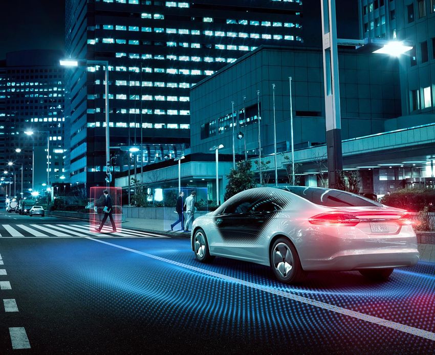
Fully autonomous vehicles could reduce accidents,
What if we     cutting them by an estimated 90% once AVs become the
took human     primary means of transport
error out of
the "driving
equation”?

               Source:
               Boston Consulting Group, “A Roadmap to Safer Driving Through
               Advanced Driver Assistance Systems”, 2015. https://goo.gl/QiupQn
The ADAS Road to AD Reality

                                                                    AUTOMATED
                 ADAS                                          Vehicle system monitors environment
      Human driver monitors environment

             UP TO LEVEL       02
                                                          LEVEL
                                                                  03        LEVEL
                                                                                    04          LEVEL
                                                                                                        05
                           L E V E L          L E V E L

                                                          CONDITIONAL          HIGH                FULL
    NO           DRIVER                  PARTIAL                            AUTOMATION          AUTOMATION
AUTOMATION     ASSISTANCE              AUTOMATION         AUTOMATION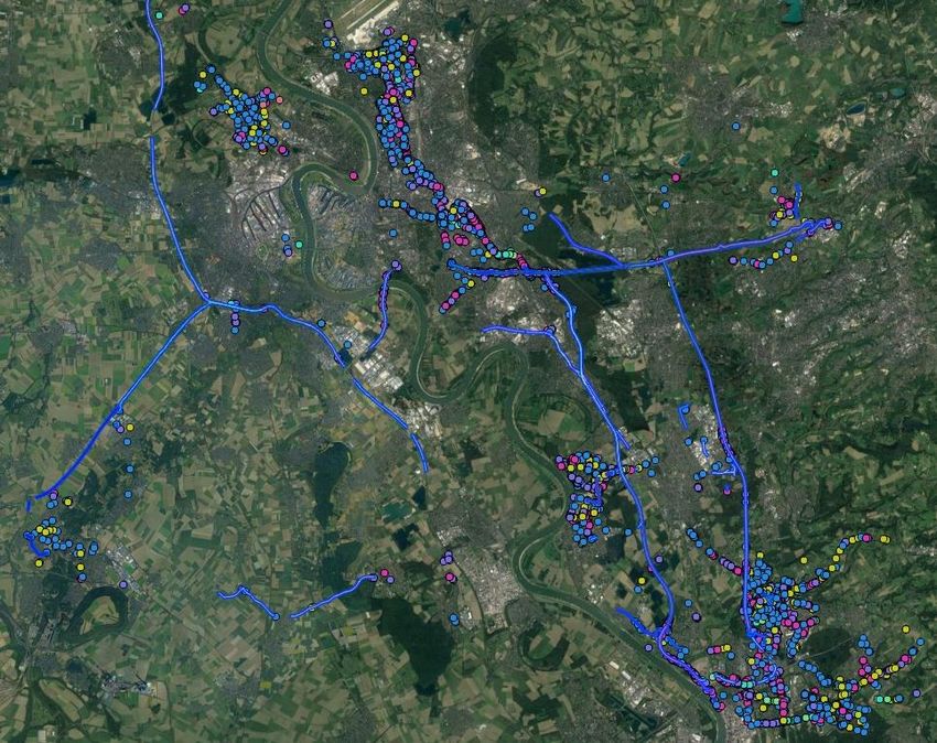
Early Warning Saves Lives

Why are collision avoidance systems effective?

• 80% of crashes involve driver inattention within 3
  seconds before the event.

• 2 second warning can prevent nearly
  all collisions.

Improves Driver Behavior – Recent IIHS Study
                                                       Collision Avoidance Systems
                                                       warn the driver in the critical
• 30% - 70% drop in FCW, LDW, and HMW for
  drivers with a Mobileye-equipped vehicle (IIHS,      seconds needed to avoid or
  2018)                                                mitigate a collision.
• 62% of drivers said they felt their
  driving improved
Safety Today
For
The   Autonomous
Tomorrow
The Three Pillars of Autonomous Driving

 Camera-Centric   Crowd-Sourced        Semantic
    Sensing          Mapping         Driving Policy

                  Responsibility-
                  Sensitive Safety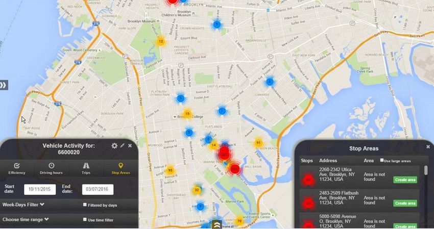
Sensing 360° awareness
Why HD maps are important for autonomous driving

 Redundancy          ‘Memory’ of            Crucial for
 for sensors          the vehicle   localization and planning
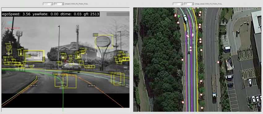
Road Experience Managment: REM™

                                    3. AGGREGATING
                                    Generating HD crowdsourced road-
            2. Anonymizing          book for the autonomous vehicle
            & encrypting
            roadscape data
                                               4. Map tiles
                                               distributed to AVs

     1.HARVESTING                             5. LOCALIZATION
     Collecting Road Segment Data             Localizing the car within 5cm
     crowed-sourced via vehicles              accuracy in the road book.
     equipped with Mobileye
REM™ Harvesting
REM™ Aggregation

Roadscape data is
aggregated to create HD
roadbooks distributed to
autonomous vehicles in
map tiles
REM™ LOCALIZATION
Redundancy for sensors
What’s   Narrow Bandwidth
         Harvested RSD compressed to 10KB/km Roadbook data size
Unique   similar to SD map, with HD quality

About
REM™?    Implementation Today
         Light data means using a 3G link.
Rem      No need for 5G.

         Local accuracy, in real time
         within the driving lane, accurate up to 5cm

         Privacy
         No user identification information passed (complies with
         GDPR)

         Leveraging the collective “memory” of the crowd
         Accurate real-time data
Data for the Road Ahead
What Advanced Road Data Will Bring

  SAFER
  Making the roads safer for everyone with collision avoidance and accident
  hotspot mapping

  SMARTER
  Support infrastructure changes in your city with actionable data

  AUTONOMOUS READY™
  Paving the way to autonomous driving with crowd-sourced RoadBooks
As vehicles equipped with Mobileye (EyeQ4) drive around a city, they can collect
SAFER -   data helping to make it safer and smarter
Hotspot   • Identification of hotspots and potentially dangerous areas
          • Traffic light and sign surveying,
Mapping   • Detection of infrastructure deficiencies
Smarter – Data Insights for Cities
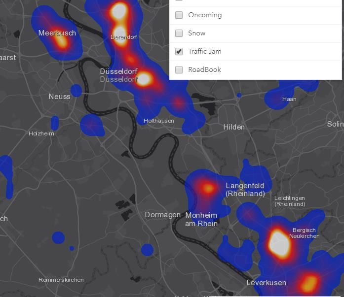
First Deployment Snapshots – Dusseldorf Komod Project
RSD streams of data received (August 2018)
Partnered
Construction Area Heat Map Traffic Jam Heat Map WithRoad Segment Data (RSD) Applications
Static Layer
✓ Traffic Signs
✓ Directional Signs
✓ Traffic Lights Position
✓ Road Markings
✓ Road Edge
✓ Lane Marks
Dynamic Data
✓ Pedestrians, Cyclists, Hazardous
Geolocations – Hotspots
✓ Driving Speed
✓ Red Light time per Traffic Light
✓ Standing vehicles, Pedestrians –
Side of the Road – HW Scenarios
✓ Construction areas
Partnered
WithMake Your City Autonomous Ready A highly accurate map, with an ultra-high refresh rate, is a critical pillar of autonomous driving. Critical REM™ data will enable AVs to eventually move safely and efficiently in your city.
Mobility-as-a-service

• Volkswagen Group and Mobileye announced plans to
  commercialize Mobility-as-a-Service (MaaS) with self-driving
  vehicles in Israel.
    Stat / Quote / Details about deal
• Development to begin early 2019 and roll out in phases in 2022

      Logo goes here
Thank You. Drive Safely!
You can also read