Multi-scalar Geo-landscape Models: Interfacing Geological Models with Landscape Surface Data - gis.Point
←
→
Page content transcription
If your browser does not render page correctly, please read the page content below
Full Paper                                                                                                  59

Multi-scalar Geo-landscape Models: Interfacing
Geological Models with Landscape Surface Data
James Melsom
University of Technology Sydney/Australia ꞏ james.melsom@uts.edu.au

Abstract: Large scale geological processes inform many of the fundamental landscape characteristics
shaping our landscapes, yet their form and nature remain abstracted from most aspects of Landscape
Architectural practice. This is due to both the scale and nature of these processes, which do not fit
within the frameworks of landscape architectural descriptive techniques, which tend to describe surface
characteristics, and often resist translation into territorial scales. Despite the dominance of geology in
many of our built environments, the geological scale remains abstract in modern literature and thought,
whether in size, materiality or timescale, from its solid strata to its eroded form (MONTGOMERY 2007).
This research develops a workflow to import three dimensional models from proprietary mining and
geological software into Landscape Architectural packages, facilitating the integration of surface con-
ditions with the underlying geological terrain. The selection, cropping, interrogation and integration of
geological data offers new possibilities for fundamental Landscape Architecture education, and the
fields of environmental design and planning, including prioritisation of land use for resource extraction,
underground water management, and earthworks in terrains with shallow bedrock geologies.
Keywords: Geological data, subterranean models, volumetric modelling, surface modelling, territorial
modelling

1      Introduction
This research examines the technical and representational potential of multi-scalar geological
models for use in landscape architecture. While the expanded potential of interaction between
the fields of geology and landscape architecture has been demonstrated previously in land-
scape research into surface geology processes (MELSOM 2015, HURKXKENS et al. 2019
among others), the geological datasets available are often fragmented, or limited to a shallow
depth, restricting the scope of such research. As a result, research and practical work is often
restricted to shallow geologies and soil science rather than engaging with the larger geologi-
cal scale. The best examples of these geological mappings are promising, yet piecemeal, of-
ten focussed on small, discreet landscape features (BOOTH et al 2011).
While Landscape Architects and other spatial disciplines are often familiar with geological
data, these give only an impression of the geology directly adjacent to the surface, while
geological sections are often sporadically spaced across the territory, rarely coinciding with
the actual site in question, making their application limited. The paper develops upon the
concept of the research “Multi-scalar Geological Models of Shelters” (MELSOM 2019), pre-
sented at the Annual Design Research Conference at Monash University in Melbourne, Aus-
tralia. The research demonstrated the analysis of surface geological features known for their
use as human habitation, with case study sites in Switzerland and Australia and their potential
to bridge the scales of comprehension between the anthropic and geological scales. The paper
contrasted detailed photogrammetric scans in Switzerland and Australia and laser scanning
of aboriginal sites in the Northern Territory, Australia (DAVID et al 2013), with local geolog-
ical datasets and morphologies. This comparison demonstrated that geological features are

Journal of Digital Landscape Architecture, 5-2020, pp. 59-69. © Wichmann Verlag, VDE VERLAG GMBH ꞏ
Berlin ꞏ Offenbach. ISBN 978-3-87907-690-1, ISSN 2367-4253, e-ISSN 2511-624X, doi:10.14627/537690007.
This article is an open access article distributed under the terms and conditions of the Creative Commons
Attribution license (http://creativecommons.org/licenses/by-nd/4.0/).
60 Journal of Digital Landscape Architecture ꞏ 5-2020
best understood at both the detailed surface characteristic and territorial scale level simulta-
neously, and commented on the challenge of bridging these conceptual scales. The LIDAR
data available for such sites showed great promise in describing surface geology phenomena
(Figure 1), however this research highlighted the shortcomings and lack of interface between
both the datasets and representational techniques of the disparate disciplines of Landscape
Architecture and the Geological Sciences.
Fundamental to this research are a series of base datasets that can be used to demonstrate the
potential for interfacing between spatial and ‘non-spatial’ geological data. As the terms im-
ply, geological data is not spatial in the design sense, but material; volumetric rather than
surface based. Conceptually it is described using both terminologies, or a hybrid of the two,
whether in language, traditional drawings or digital sources.
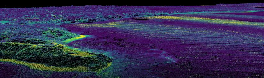
Fig. 1: Coastal Elevation and Depth LIDAR data, including headland and beach, south of
Byron Bay, NSW showing contrasting geological material. The visualisation of
purely surface-based geology types limits the understanding of the broader surface
interaction of the consolidated and unconsolidated layers, their formation and state
of erosion. Source: Data – Geoscience Australia 2015, visualisation by Author.
This research integrates a particular geological dataset, the ‘Seamless Geology Project of
New South Wales’ (PHILLIPS 2015), as a potential source of these subterranean geological
datasets for integration into Landscape Architectural models of the territory. While the de-
tailed characteristics of this dataset are expanded in section 3.1, the reason for its existence
should be acknowledged: in the introduction of the particular NSW geological source dataset
visualised in this research, the author makes clear that this data has been created primarily
for the discovery and procurement of underground resources and extractive industries
(ROBINSON 2017).
While this paper does not touch in depth on the ethical implications of using such datasets
ostensibly generated for use in mining exploration, such data could equally form part of an
argumentation to protect certain landscape features. Such mappings, when combined directly
with design and planning approaches, could support particular extractive techniques, influ-
ence their approach or sustainability, or in contrast be combined with regional strategies that
argue the non-extraction of strategic underground resources in specific cases, contrasting
with the implied original use of the documents. Such data could also be characterised to high-
light and specifically demonstrate the fundamental relationship between specific geological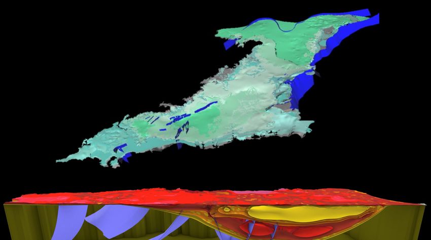
J. Melsom: Multi-scalar Geo-landscape Models                                                   61

features and the surface conditions they contribute to generate, and our ability to link geologi-
cal processes directly to their influence on our surface habitation and environments.
While geological layers are often thought of as inert and immutable, environmental processes
are constantly negotiating these layers as water, gasses and slower geological shifts take
place. The anthropic incursions into these zones in the form of water and resource extraction,
and exchange techniques such as fracking are just some of the active ways in which these
subterranean layers are being transformed, especially in Australia. Specific local geograph-
ical phenomena such as the suspected link between historical flooding events and the re-
charge of the water table in the Sydney geological basin is an example of the potential for
geological models which directly influence the design and planning decisions applied to their
surfaces. Underground aquifers are a further example of the need for a 3 dimensional under-
standing of the underground; often forming separate horizontal layers, separated by ‘aqui-
tard’ layers, they maintain different water characteristics and this separation often impedes
their replenishment (ACWORTH 2015). The overly simplistic visualisation and understanding
of such systems is clearly problematic for sustainable development.
The implications of integrating geological data more deeply into landscape architectural
models has clear applications for education, design, spatial planning and interdisciplinary
collaboration. Continuing upon this premise, this research project in contrast seeks to develop
the specific interaction with digital geological datasets, and their interface with specific sur-
face geologies. To this end, a characteristic site has been chosen in order to interface with the
unique publicly available geological dataset in New South Wales, Australia its data rich en-
vironment and characteristic local surface geology. While there is not an existing demand for
geological data in landscape architecture, there has also been to viable means of supply. An
increased awareness, supply and accessibility to such data could feasibly result in an in-
creased demand and viability of 3d geological data, and further increase its diversity beyond
interests for mining and extraction.

2     Research Case Study
The chosen case study site of investigation is the coastal area of Tallows Creek, south of
Byron Bay, NSW, which features a dune landscape or ‘unconsolidated’ geological layer of
coastline currently in a phase of accelerated coastal erosion, combined with a ‘consolidated’
exposed geological headland, which accelerates processes of erosion and deposition, depend-
ing on the direction of storm fronts (BSC 2016). While this collaboration between the local
shire and the University of Technology Sydney has not yet been published, the first results
were presented at the January 2020 Byron Shire Meeting and public consultation, and con-
firmed both the relevance of Landscape Architecture in discussions of coastal erosion pro-
cesses, and the significance of the visualisation of the entire system, including territorial geo-
logical and hydrological processes.
The local study began through an institutional appeal to communicate the scale and nature of
the processes of coastal erosion, in a long term state of retreat, in public discussions including
private stakeholders. While increased climate variability has accelerated these processes, it
has also distracted from the fact that this tendency is a fundamental characteristic of this area
of coastline. The visualisation of this interaction of the local unconsolidated and consolidated
geology with local hydrological systems, undertaken by the university, is seen as a key aspect
of the public awareness, planning and design of the area.
62                                             Journal of Digital Landscape Architecture ꞏ 5-2020

Fig. 2: Coastal Elevation and Depth LIDAR data, including headland and beach, south of
        Byron Bay, NSW showing contrasting geological material. The visualisation of
        purely surface-based geology types limits the understanding of the broader surface
        interaction of the consolidated and unconsolidated layers, their formation and state
        of erosion. Source: Data – Geoscience Australia 2015, visualisation by Author.

To understand, map and communicate the longer geological timescale of local coastal evo-
lution, it is essential to be able to visualise and incorporate the geological layers composing
the site. In this project, landscape architecture facilitates the combination of the geological
scale with various datasets, including coastal engineering data, bathymetry, water table depth,
depth-based bore water quality, and the habitation of the evolving coastal dune system. Such
visualisation work can directly influence and interact with planning and design decision mak-
ing in these complex systems. This research paper focusses on the integration of the geolog-
ical foundation of this research.

3     Synthesising Geo and Surface Datasets, Scales and Workflows
3.1   Sourcing and Datasets and Identifying their Potential for Interface
In order to demonstrate a useful interoperability of geological data with visualisation and
design data, various datasets are interfaced to bring this research together. The goals of the
ongoing research topics of the case study site include both LIDAR (Publicly available da-
tasets from 2015) and small-scale co-incident seasonal photogrammetry datasets (UTS case
study data, 2019); these have been chosen as the key landscape surface datasets for integra-
tion with the geological models of the region. The choice of a complex case-study site in
J. Melsom: Multi-scalar Geo-landscape Models                                                  63

continuous flux means that a large number of data sources and formats are relevant to this
particular research project. A software solution, interface and workflow that enabled the mix-
ture of design-based outcomes, physical modelling, parametric analysis tools as well as the
specific ability to easily manipulate meshes and point clouds within the same model shaped
these decisions.
These software and workflow criteria were resulted with the choice of Rhinoceros, Grass-
hopper, and QGIS as the focus of this research, and reflecting the workflow used within the
case study. They were chosen for this purpose for practical research and teaching reasons,
being accessible to both architects and landscape architects, and allowing easy development
of scripting and plugin development for the researcher.

Geological Data and Sources
The ‘Seamless Geology Project of New South Wales’ (PHILLIPS 2015), developed in Aus-
tralia by the state government of New South Wales demonstrates the large scale potential of
combining various datasets from across the state into one digital archive. (Figure 2) The data
forms three dimensional meshes that describe the seams and interfaces between distinct geo-
logical types, as well as key fissures and fold lines.
As specified by the authors of the dataset, the aim of the NSW Seamless Geology Project is
to create a geodatabase that organises all available geological data into layers (or time slices)
that represent the major tectonic cycles of evolution of the Tasmanides or geological for-
mation of NSW. The data is organised into main layers or ‘time slices’ as the authors name
them, which organise the underlying data: Quaternary, Cainozoic, Basins and Basement lay-
ers. This is also to ensure that inevitable gaps in certain layers (and data) are supported by
the other layers; certain areas of the basement layer are relatively un-mapped in many areas.
The data was compiled from the interpolated data from geological drilling sites, 150,000
statewide water bore drilling datasets, and other exploratory material (ROBINSON 2017).
For this reason, overlaid with this is a three dimensional mapping of the accuracy of the
mapped data, representing the varied accuracy of the interpolation involved. The included
confidence layers can be used to help identify the accuracy of these zones, and areas of high-
est detail.
Geological mapping is an exercise in abstraction, with the density of data and level of detail
often correlation with the exploration for specific resources. For this reason, the resulting
data is not neutral in its focus and consistency, and it is important to acknowledge areas that
are less detailed or should be understood in a specific context.
Since the early 2000s, geological modelling software has made various advances in the de-
scription of ‘non spatial’ (subterranean) data, combining manipulation of geological data
with attribute management, visualization and inquiry tools (APEL 2006). With characteristics
similar to GIS, this allows the same data to represent both the geological seams as distinct
‘surfaces’ as well as use them to define separate volumetric regions, a fundamental difference
to spatial modelling, but one which is familiar to Landscape Architectural design (Figure 3).
To this date, these data sources have remained restricted to geological CAD softwares and
mining operations planning solutions.
64 Journal of Digital Landscape Architecture ꞏ 5-2020
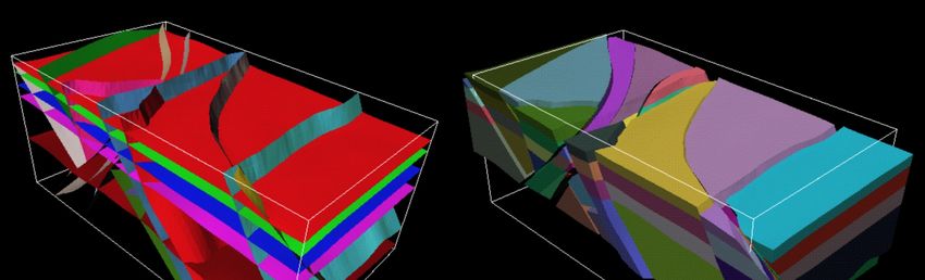
Fig. 3: Simultaneous geological models – Fault Horizon Structural Framework Model and
‘Exploded’ Layer Model. This differentiation shows the volumetric characteristics
and conceptualization required understand and visualize complex geologies. Source:
Schlumberger software visualization.
The geological data is available for open download, though while the dataset is in a format
that is visually familiar to designers, this accessibility is deceptive. The data remains some-
what proprietary insofar as the references, labelling and metadata are lost on typical import;
it is only accessible via software used primarily in the mining industry with specific charac-
teristics to non-spatial data. This software distinction is important, however, as it reveals the
specificity of the datasets and their application in transcribing this ‘non-spatial’ data, a key
requirement of the datasets. In the case of the ‘Seamless Geology project’ these also exist as
separate entities; computationally they are often not efficient to generate in realtime. Con-
ceptually, the ‘model’ for terrain holds other potentials for landscape architecture, which will
be mentioned later in this paper.
3.2 Integration of Datasets
It is essential for these datasets to be simultaneously displayed, manipulated and interfaced
for analysis, while allowing the use of three dimensional tools from a CAD and parametric
toolset where critical in the choice of Rhino and Grasshopper. This flexibility of visualisation
and specificity of database management has been replicated in the first instance in this re-
search through scripts for conversion, placement, and cropping, visualisation, analysis, live
linking to QGIS and export using the visual interface of Grasshopper for Rhino.
In this case study, the sectional lines have been animated through the project site to illustrate
the shifting sectional geology, as well as detailed anthropic change to the site; sand mining
operations from the 1930-1950s substantially altered the morphology of the dune lines and
subsequent revegetation. The implied dune morphology can also be added to the model. Five
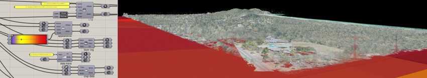
main aspects were scripted in Grasshopper to facilitate full integration of the datasets: (a)
projection compensation, (b) asset import, (c) attribute linking, (d) dataset cropping, and (e)
simple analysis features (Figure 4, analysis specifically elaborated in Section 3.3).
J. Melsom: Multi-scalar Geo-landscape Models 65
Fig. 4: Grasshopper tools developed for applications of data geological data import, manip-
ulation, visualization and (optional) custom colour distribution. Unconsolidated lay-
ers (foreground) can be seen in context to the consolidated headland (background),
and emergent surface geology (in red, top-left). Source: Author.
An Australian projection system common to the local area (Australia has many due to its
size) GDA94:56 was chosen (a) to allow all datasets to be placed accurately. Scripting al-
lowed for offsets between the data types, to maximise accuracy of data at such scales, and to
allow shifts to the NSW state-wide projection. This also allows design elements and local
reference markers to be correctly displayed in metres and displayed accurately, allowing di-
rect interface with GIS software. The scripted elements worked relatively well to streamline
import of different datasets, allowing for the fragmentation of the statewide model which is
organised into various configurations, as is common in such geological datasets, whether
according to individual features (often sourced from a separate .TS (GOCAD) file) or com-
posing new relational sets.
Automation of the import (b) of point clouds and of the geological DXF meshes involved the
distribution of layers, and linking of attributes (c) provided separately. The otherwise anon-
ymous mesh features were coloured and attributed to named layers on import, based on a
colour scale that can be adjusted easily by the user. The ‘time scales’ or four key organisa-
tional layers, as well as interpolation accuracy data is also distributed at this point. The at-
tribute data is partially maintained in an XML style format for which a custom interpreter
was written. In addition, the increasing use of point cloud modelling, visualisation and data
structures in geological and mining applications demonstrates a further area of possible in-
terfaces with spatial planning practices (LYONS-BARAL 2016). The various attributes of
the point clouds are maintained and can be further subsampled or manipulated within grass-
hopper.
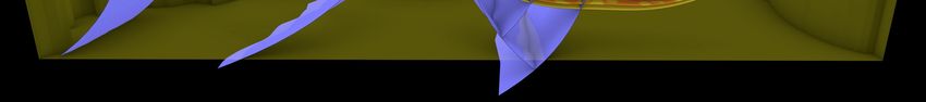
The cropping of the data (d) is simplified within Rhino with a script that can implement
multiple cropping planes. The flexibility of placing sectional planes to reveal the geological
section and transverse relationships provides a descriptive sequence of sectional data; lever-
aging the potential of the fully three dimensional geological dataset. The investigation with
sectional (vertical) cropping as a standard approach works well for primary interrogation of
the datasets, revealing essential sectional relationships, especially where other complex da-
tasets are available, such as bore depths and water table interaction. Dynamic sectional inputs
revealed further potential, with horizontal planar sectional cropping showing depth based
transverse relationships, or even angular cropping sections that can rotate in three dimensions
and be oriented to the sloped fault lines and specific geological planar geometries.66 Journal of Digital Landscape Architecture ꞏ 5-2020 3.3 Data Interaction and Analysis In the development of this toolset, interaction and flexibility of manipulation of the various data sources is the key aim. Within the case study, the requirement to integrate scientific coastal study data, incidental stakeholder observations, coastal retreat guidelines, and weather data (among other datasets) with the various types of conventional landscape data required a flexible set of tools and visualization methods that could evolve over the course of the research. While grasshopper and associated plugins provide a wide array of approaches to analysis, specific tasks and methods of interfacing with the data have been facilitated as part of this research. These tools form scripted simple analysis of features (e) and allow common and essential feedback to be simplified and customized to the data sources, and maintain links to reference data. This workflow was also necessary to facilitate active links and export of the data in compatible formats with the source data for interoperability with QGIS and other GIS solutions. The availability of detailed data and underground datasets such as bore depths, salinity, and water quality also be integrated into the research model. This geo-located data can only be understood and characterized in the context of the unconsolidated geology and soil profiles of the site, and the hydrostatic interaction of the water table and the Pacific Ocean. The ongoing case study research involves the addition of dynamic surface water quality data to the model to further understand the interaction of the water table with the surface water condi- tions. The ability of Grasshopper to source data directly from online .XML and website data sources facilitates this process. Additional tools developed included dynamic depth calculations which annotate surface depths automatically, and the generation of 2D sections with layers to match the reference geo-data and maintain relevant attributes, and bore data density mapping, to understand the local demands on the underground water supply. The use of Grasshopper allows access to extensive parameter based tools to then be leveraged for various approaches to data analysis, and importantly, visualization. Access to various render approaches is especially useful where multiple data types are being integrated, with point clouds, curves, meshes and surface geometries interacting. This enables a flexible and ani- mated approach to rendering and data visualization, yet still allows interoperability for GIS platforms and geophysical software applications, allowing the landscape architect to anno- tate, query and otherwise augment datasets in collaborative projects with engineers, geolo- gists and stakeholders. 4 Discussion The general aims of the research were dictated by a parallel case study, which required the integration of terrestrial with subterranean data. The resulting development of a series of tools to allow this integration was successful, allowing a high level of enquiry, visualisation and design potential for landscape architectural applications. In the process, it was also identified that interfacing with other platforms such as QGIS and more database oriented approaches are absolutely preferable and necessary, in order to leverage the strengths of those platforms. The integration of tools into this toolset to this point has been streamlined to the needs of the particular research case study. The toolset is currently limited in general use by its connection
J. Melsom: Multi-scalar Geo-landscape Models                                                  67

to specific software, however this specificity has been found to accelerate the application and
integration of these applications. In order to be practically useful for other users and for gen-
eral applications it will need improvement in scope and a more general toolset, as well as
integration into other software packages.
Currently UTS landscape architecture students working on the case study have access to the
tools, and the growing requirements of the project are informing their development. As a
working set of research tools, there is much potential in its current state or for improvement
for broader applications, and integration of the datasets into other design softwares. The cur-
rent toolset requires development for general use and global applicability, and could certainly
be released as a stand-alone set of tools for general use by landscape architects and related
fields. The coastline of Sydney, NSW and its distinctive exposed sandstone geological for-
mations are a direct example of the connection of the consolidated geological base and the
surface terrain. While a particular case study, the approach demonstrates applications for
varied site typologies, each with their specific geology, topography, bathymetry and land-
scape morphologies.

5     Conclusion and Outlook
This research demonstrates the possibility to render accessible immense geological data
sources that have implications far beyond the mining and resource extraction industries. In
many cases, better understanding of the underlying geology can have direct implications to
land-use, temperature, and surface water characteristics including flooding, water filtration
and storage. The research has potential to engage directly with geological modelling, or cre-
ating a truly ‘volumetric’ approach to geological sections, using voxels, or point clouds.
While some compelling tests were made in this direction, the technique requires more work
to become useful, and was beyond the scope of the chosen case study.
As mentioned earlier in this paper, the potential for the geological approach to ‘non-spatial’,
volumetric modelling has other implications. The detailed layering of soil, including top-soil,
sedimentary layers and underlying sands, silts, clays or detailed rock surfaces could all prac-
tically and usefully be represented by such a technique. Volumetric models can yield direct
volume, depth, and perhaps also lead to understanding of permeability, infiltration, structural
integrity, as well as locate services and root systems of plants.
In the current time of the anthropocene and post-anthropocene, associated discussions have
been accompanied by awakening of awareness of geology especially in our extractive prac-
tices, and resource worth. This gaze has exposed the uneasy relationship with the territory
under our feet, and put into question assumptions as to its resilience to our interventions,
whether cultural, engineered or extractive (YUSOFF 2013). The further expansion of re-
search has the potential to render visible the interface between the surface geologies that
interact with the human scale, and the slow geological processes below of the surface, open-
ing new avenues for understanding and the sharing of interdisciplinary scientific knowledge.
It is clear that spatial sustainable spatial design and planning can benefit from a further un-
derstanding of subterranean data and its interaction with the surface. The impact of our hab-
itation on the environment has never been clearer in history, and these investigations and
potential mitigation strategies are crucial in the design and planning disciplines.
68                                            Journal of Digital Landscape Architecture ꞏ 5-2020

Initial feedback from the local government on this case study suggests that this approach has
the potential to allow designers to allow direct engagement with the realms of environment,
economy and policy. While primarily focused on access to data and its enquiry, as has been
mentioned there are many potential applications for an expanded field of tools and subterra-
nean methods. A renewed interest in geology and the environment belies a new relevance for
the voice of Landscape Architecture, as a discipline that stands between the arts and the sci-
ences; working both with and forming the terrain through its practice. Methods that success-
fully marry the scales of our surface models and the geological have the potential to define
new interfaces for landscape dialogue, practice and agency.

References
ACWORTH, R., TIMMS, W., KELLY. B, MCGEENEY. D., RALPH, T., LARKIN, Z. & RAU, G.
   (2015), Late Cenozoic paleovalley fill sequence from the Southern Liverpool Plains, New
   South Wales – implications for groundwater resource evaluation. Australian Journal of
   Earth Sciences, 62 (6), 657-680.
   http://dx.doi.org/10.1080/08120099.2015.1086815
APEL, M. (2006), From 3d geomodelling systems towards 3d geoscience information sys-
   tems: Data model, query functionality, and data management. Computers & Geosciences
   32, 222-229.
BOOTH, K. A. & BRAYSON, J. (2011), Geology, landscape and human interactions: examples
   from the Isle of Wight. In: Proceedings of the Geologists’ Association 122, 938-948.
BSC – Byron Shire Council (2016), Coastal Zone Management Plan Byron Bay Embayment,
   Byron Shire Council, Byron Bay, NSW, Australia.
DAVID, B., DELANNOY, J. J., GUNN, R., CHALMIN, E., CASTETS, G., PETCHEY, F., APLIN, K.,
   O’FARRELL, M., MOFFAT, I., MIALANES, J., GENESTE, J. M., BARKER, B., SADIER, B.,
   KATHERINE, M., MANATAKI, M. & PIETRZAK, U. (2017), Dating Painted Panel E1 at
   Nawarla Gabarnmang, Central-western Arnhem Land Plateau. In: DAVID B., TAÇON P.,
   DELANNOY J. & GENESTE J. (Eds.), The Archaeology of Rock Art in Western Arnhem
   Land, Australia, ANU Press, Australia, 245-302.
DAVID, B., TAÇON, P., GUNN, R., DELANNOY, J. & GENESTE, J. (2017), The archaeology of
   western Arnhem Land’s rock art. In: DAVID B., TAÇON P., DELANNOY J. & GENESTE J.
   (Eds.), The Archaeology of Rock Art in Western Arnhem Land, Australia. ANU Press,
   Australia, 1-18.
HURKXKENS, I., MIRJAN, A., GRAMAZIO, F., KOHLER, M. & GIROT, C. (2019), Robotic Land-
   scapes: Designing Formation Processes for Large Scale Autonomous Earth Moving. In:
   GENGNAGEL, C., BAVEREL, O., BURRY, J., RAMSGAARD THOMSEN, M. & WEINZIERL, S.
   (Eds.), Impact: Design With All Senses. DMSB 2019. Springer, Cham.
LYONS-BARAL, J. (2016), Applications of point cloud technology in geomechanical charact-
   erization, analysis and predictive modeling. Mining Engineering, 68 (5), 18.
MELSOM, J., HURKXKENS, I. & GIROT, C. (2015), Directed Deposition: Exploring the Roles
   of Simulation and Design in Erosion and Landslide Processes. In: Peer-Reviewed
   Proceedings ACADIA 2015: Designing the Anthropocene, Cincinnati, OH.
MELSOM, J. (2019), Multi-scalar Geological Models of Shelters, Annual Design Research
   Conference: Real Material Ethereal. Monash University, Melbourne, Australia (Pro-
   ceedings not yet published).
J. Melsom: Multi-scalar Geo-landscape Models                                             69

MONTGOMERY, D. (2007), Dirt: The Erosion of Civilizations. University of California Press,
   Berkeley.
PHILLIPS G., COLQUHOUN, G. G., HUGHES, K. S. & DEYSSING, L. (2015), Seamless geology
   of New South Wales: approach, methodology and application. Quarterly Notes of the
   Geological Survey of New South Wales, 145, 1-28.
ROBINSON, J. A. (2017), Statewide post-carboniferous cover thickness model for New South
   Wales. Geological Survey Report No: GS2017/0126, NSW Department of Industry
   Resources & Energy, 7-43.
YUSOFF, K. (2013), Geologic life: prehistory, climate, futures in the Anthropocene, Environ-
   ment and Planning. Society and Space 2013, 31, 779-795.
You can also read