National Infrastructure Access Programme (NIAP) - Research and Innovation Projects - SmartBay
←
→
Page content transcription
If your browser does not render page correctly, please read the page content below
Ollscoil Chathair Bhaile Átha Cliath
Dublin City University

                            SMARTBAY – IRELAND’S NATIONAL RESEARCH,
                                 TEST AND DEMONSTRATION PLATFORM

          National Infrastructure Access
                      Programme (NIAP)
                         Research and Innovation Projects
                                                  Dublin City University
Projects
      Background                                                  1

      Support by SmartBay Ireland for NIAP projects               2

1.    Proof-of-concept flood warning decision support –
      Visualisation                                               3

2.    Deployment and Analysis of Smart Inertial Measurement
      Units (IMU) in Marine Environment (MIMU)                    5

3.    Real-time Remote Monitoring of Surface Currents
      and Waves off the Irish West Coast                          6

4.    Developing a Primary Node in the National MSFD
      Underwater Noise Monitoring Network                         7

5.    Location of submarine and intertidal groundwater
      discharge to Kinvara Bay Galway, Ireland                    9

6.    New Infrastructure: Galway Bay Underwater Cable            10

7.    Investigation of Juvenile Salmon Migration Route and Sea
      Trout Habitat Use in Galway Bay using Acoustic Telemetry   12

8.    Galway Bay Biogeochemical Time Series (GALBAY):
      Seasonal cycles of CDOM and Synechococcus Abundance
      in Galway Bay                                              13

9.    Antifouling Strategies for Marine Deployed Structures      15

10.   Monitoring the Impact of renewable energy devices
      on small coastal cetaceans through coastal monitoring      17

11.   RAFTS (RAinFall aT Sea)                                    19

      Contact Details                                            21
Background
The SmartBay NIAP fund was made available in 2012 by Dublin City University to enable

                                                                                                      NATIONAL INFRASTRUCTURE ACCESS PROGRAMME (NIAP)
researchers to access the SmartBay Ireland National Test and Demonstration Facility in Galway
Bay. Research proposals were invited for funding under a number of activity types that are in
line with the objectives of the SmartBay PRTLI Cycle 5 programme. This fund provided small
awards (typically €2-25K) to research teams through a national competitive process, which was
open to all higher education institutions on the island of Ireland.

Proposals to access the infrastructure were brief and required information on the researcher(s),
a description of the proposed research and its potential impact to the research team arising
from the access to SmartBay Ireland.

A key aspect of the NIAP was to establish a modest fund to support researchers wishing
to access the infrastructure through a contribution to additional costs associated with
deployments. The call for proposals to access the infastructure was open to all Irish Higher
Education Institutions. We regarded this as essential to ensure that the facility is national,
rather than regional in character, acting as a catalyst to test and validate innovative technology
platforms and services under real conditions through field deployments, and therefore assisting
the transfer of knowledge into products. Our goal was therefore to rapidly grow the user base
to encompass academic research teams, SMEs, and MNCs, nationally and internationally,                      1
and demonstrate significant socio-economic impact through the growth of an associated
industry base that commercialises the research outputs, or uses the technologies to enhance

                                                                                                      RESEARCH AND INNOVATION PROJECTS
productivity.

Since the launch of the NIAP in 2012, greater than 20 projects have been supported and by some
groups that had not tested technology in the marine environment. Therefore SmartBay plays a
critical role in connecting existing research capacity with commercial opportunity, consistent
with national policy, as articulated in the ‘Smart Economy’ strategy. In addition, SmartBay
offers a unique resource for training and education of graduate and postgraduate students in
the challenges of bringing research out of the laboratory, into real scenarios, as part of a larger
multidisciplinary effort, wherein they can clearly appreciate the contribution of their work to
knowledge generation and economic development. Without this fund the research teams would
not have been able to test their technologies in the marine environment with such ease, and
therefore drive their research forward successfully. The projects and teams utilising SmartBay
are funded through a wide range of mechanisms and the NIAP facilitates the translation of that
research into the marine environment.

A number of technologies tested in SmartBay have since received additional funding or have
progressed toward commercialisation. In summer 2015 a final call for proposals under the DCU
funded NIAP took place for groups interested in using the cabled observatory. The cable was
successfully deployed in 2015 and many projects will develop through accessing this marine
observatory.

Fiona Regan
DCU Water Institute, Marine Environmental Sensing Technology Hub (MESTECH)
NIAP Co-ordinator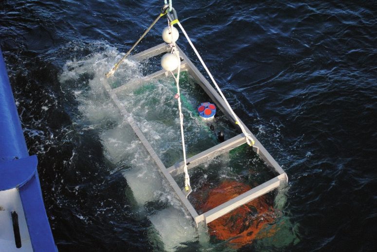
Support by SmartBay Ireland for NIAP projects
                                                  As managers and operators of the National Test and Demonstration Site in Galway Bay,
                                                  supporting the Marine Institute, SmartBay Ireland developed a set of operational capacities
                                                  that are fully available to support every NIAP project. These capacities include marine
                                                  operations, hardware and software components integration, remote marine data acquisition and
                                                  transmission to shore, data management and storage including local supply chain engagement.
                                                  Each successful NIAP funded project involves a pre-proposal consultation with SmartBay
                                                  staff to scope and assess project specific requirements. A kick-off meeting is held with the
                                                  applicant’s project team, during which the project is reviewed, next steps determined and
                                                  project management commences. Below are some examples of how this happens:

                                                  For Dr. Joanne O’Brien’s project (GMIT) to “assess the effect of wave energy devices on the
                                                  presence of harbour porpoises”, self-logging hydrophones must be deployed in the test site.
                                                  Dr. O’Brien prepared and delivered the hydrophones and SmartBay’s technical team: personnel
                                                  manages the deployment; configured and setup a mooring line and buoy; arranged for a
                                                  vessel to carry out the deployment and executed the installation of the hydrophones in the test
                                                  site. A few months later the SmartBay team recovered and delivered the hydrophones to the
                                                  researcher.

                                                  For Dr. Sheena Fennel’s project (NUIG) to “measure rain fall properties in the ocean”, it was
RESEARCH AND INNOVATION PROJECTS

                                                  necessary to install a rain collector in the test site. SmartBay made a platform available (the
                                                  Galway Bay SmartBuoy) and discussed with the team how to install the rain collector in the
                                                  buoy whilst meeting sampling requirements. After installation and deployment, on every visit
                                                  to the buoy the “recipient” with the rain sample was collected and retrieved from the buoy by
                                                  SmartBay personnel and a new, empty “recipient” left in place.

                                                  In the case of a more complex project such as Dr. Gerry Sutton’s (UCC) “development of a
                                                  primary node in the National MSFD underwater noise monitoring network”, a suite of project
                                                  specific skills had to be put in place to: design and manufacture an underwater platform and
                                                  restraining mechanism for a hydrophone and its cable; design, manufacture and install a
                                                  cable restraining mechanism in the surface buoy; provide advice and suggestions for power

2                                                 and data connectivity to the hydrophone and its control box; prepare the buoy to provide power
                                                  and data links to the hydrophone; integrate in the buoy’s data flow to shore the data acquired
                                                  by the hydrophone; develop routines to process this new dataset and make it available to the
                                                  researcher and the scientific community and prepare and deploy the hydrophone and the control
NATIONAL INFRASTRUCTURE ACCESS PROGRAMME (NIAP)

                                                  box in Cork’s Smartbuoy located off Roches Point. All of this work was carried out in accordance
                                                  with SmartBay’s Health, Safety, Environment and Quality (HSEQ) system.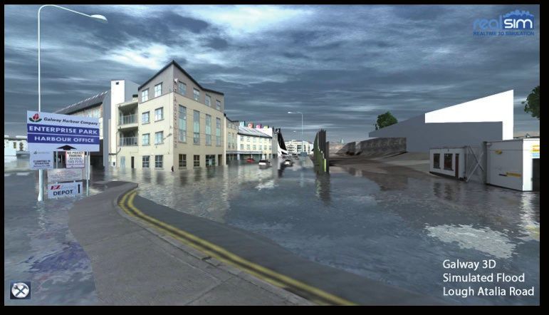
Proof-of-concept flood warning decision support –
Visualisation

                                                                                                    NATIONAL INFRASTRUCTURE ACCESS PROGRAMME (NIAP)
Lead PI: Michael Hartnett
Stephen Nash – National University of Ireland, Galway
Ivor Marsh – Monterrey Software Solutions
Gavin Duffy – RealSim Ltd.

                                                                                                    3

                                                                                                    RESEARCH AND INNOVATION PROJECTS
Figure: 3D flood simulation at Lough Atalia, Galway. Image courtesy of Real Sim.

This project was the result of academic/industry collaboration between the National University
of Ireland, Galway, SmartBay Ireland, Monterrey Software Solutions and RealSim. The NIAP
funding allowed the project to focus on the visualisation and validation of 2-dimensional
hydrodynamic model outputs for Galway Bay. The project took a novel and innovative approach
in terms of developing software components that provide dynamic content visualisation i.e.
environmental data from sensors with near real time feeds using GIS and the RealSim 3D
visualisation engine. This project provided a proof of concept regarding the potential to develop
a high resolution coastal flood prediction system within a high quality GIS and visualisation
environment.

The primary objectives of this research were to 1) Validate the Galway Bay hydrodynamic model
outputs using SmartBay data and other relevant auxiliary data and 2) Integrate the model
outputs into GIS and then visualise this data through a 3D game engine.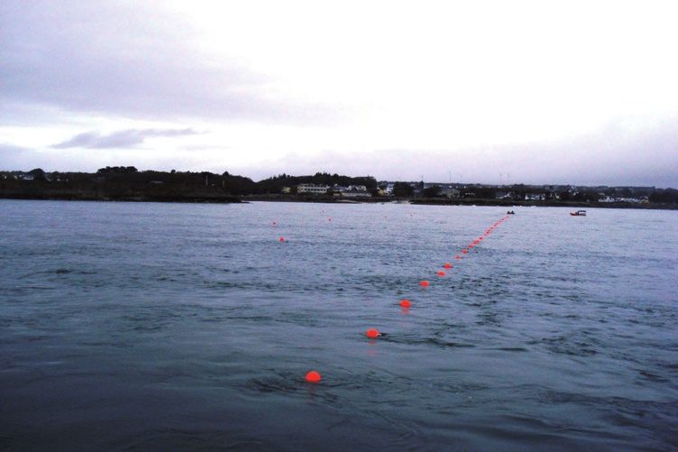
Figure: Showing Bathymetry of Galway Bay. Image courtesy of NUI Galway.

                                                  The area of interest for visualisation of model outputs was the Inner Bay area. The model
RESEARCH AND INNOVATION PROJECTS

                                                  was calibrated and validated by comparing modelled and measured water levels and current
                                                  velocities at the instrument locations. Computer code was developed which facilitates a two-
                                                  way communication between the spatial data warehouse and the 3D Visualisation engine. A
                                                  prototype system was developed to visualise the output from the 2-dimensional hydrodynamic
                                                  model for Galway Bay. The 3-dimensional model of Galway Bay, which was developed during
                                                  the course of this research is utilised in the visualisation engine and provides the terrain for the
                                                  simulations. The system prototype has an embedded visualisation engine and several interface
                                                  tools that allow the user to select a model simulation and visualise the water surface elevation
                                                  for any time during the tidal cycle of that model simulation. The figures illustrate the rising
                                                  water surface elevation throughout two specific time periods during the model simulation.

4
NATIONAL INFRASTRUCTURE ACCESS PROGRAMME (NIAP)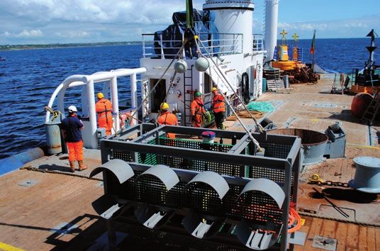
Deployment and Analysis of Smart Inertial Measurement
           Units (IMU) in Marine Environment (MIMU)

                                                                                                                NATIONAL INFRASTRUCTURE ACCESS PROGRAMME (NIAP)
           Lead PI: Brendan O’Flynn, Tyndall

                                               Objectives
                                               The objectives of this project are: to establish the needs and
                                               specification requirements for Inertial Measurement Units
                                               (IMU) applied to ocean waves through consultation with end
                                               users and commercial partners in this area; to confer with
                                               SmartBay personnel and stakeholders and define the exact
                                               motion information that is most important to measure; to
                                               re-design, adapt, marinise and ruggedise Tyndall’s IMU to be
                                               suitable for deployment in harsh environments such as those
                                               experienced in the marine world for numerous application
                                               in the space; to deploy and maintain the IMU’s on SmartBay
                                               buoys with SmartBay assistance in a real life scenario; to
                                               analyse and contextualise the data gathered and disseminate      5
                                               to SmartBay stakeholders and to integrate next generation
                                               technology into existing infrastructure available.

                                                                                                                RESEARCH AND INNOVATION PROJECTS
Figure: the main board of the WIMU device inTwo WIMUs (Wireless IMU) were deployed in two locations
comparison to a two Euro coin.
                                            managed by SmartBay (the Smartbuoy off Roches Point,
                                            Cork, and the Galway Buoy in the test site, in Galway Bay).
           Data from each WIMU was delivered in near real time to SmartBay’s data platform on shore
           and made available to researchers in Tyndall and at TFI (Technology From Ideas).

           Relevance
           For the Tyndall National Institute, transfer to existing Irish electronics manufacturing and
           design companies is the targeted method of direct economic benefit. It is anticipated that the
           take up of this technology by such companies will also produce benefits to the Irish economy
           through improved efficiencies, greater product quality and the enhanced commercial advantage
           gained by the end users of the technology in the area of intelligent environments. It is envisaged
           that transfer would be by means of licence of IP. The viability of a new spin-off company to
           commercialise the technology is being considered.

           With the level of intellectual property generation through both patents and know-how there
           may be an opportunity for the establishment of a high-technology startup company. Tyndall has
           established start-ups in the recent past based on technology developed in-house. There are
           clear financial incentives in place to motivate Tyndall staff to undertake work leading to such
           start-ups.

           Tyndall will also incorporate the research work completed in the project (as appropriate) into its
           training and postgraduate lecture courses, as well as actively disseminating within the research
           departments in UCC, and Irish and European Universities. The results of this project have been
           published internationally.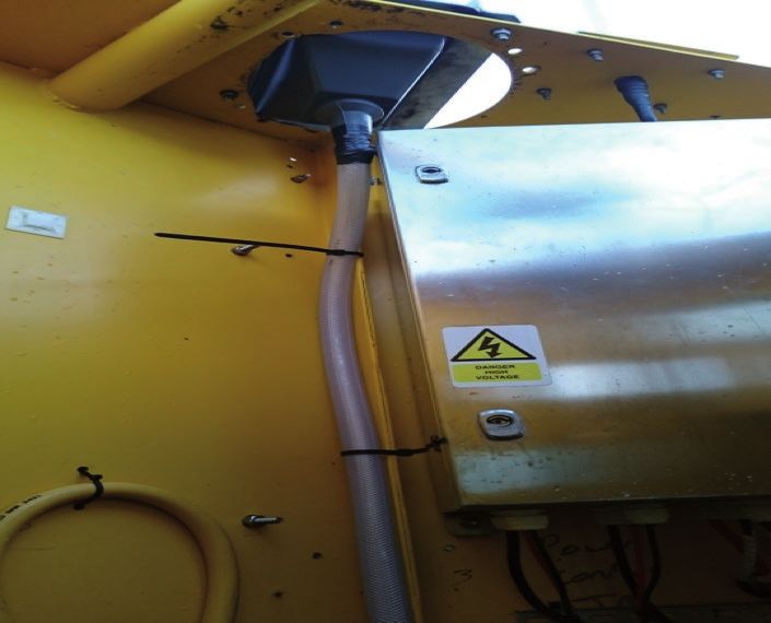
Real-time Remote Monitoring of Surface Currents
                                                  and Waves off the Irish West Coast
                                                  Lead PI: Stephen Nash. National University of Ireland, Galway

                                                  The primary aim of this project was the validation of NUI Galway’s West Coast Radar System,
                                                  using current velocity data collected from an ADCP deployment. It was proposed to deploy an
                                                  Acoustic Doppler Current Profiler (ADCP) off the County Clare coast for a 3-month deployment
                                                  period. The Integration Grant was required to cover the cost of fabricating a support frame for
                                                  the ADCP during its deployment and vessel hire for deployment and retrieval. The deployment
                                                  was conducted by SmartBay Ireland.
RESEARCH AND INNOVATION PROJECTS

6                                                 Figure: Surface current data for Galway Bay.                    Figure: High Frequency Radar deployed
                                                                                                                  in Spiddal, Co. Galway.
NATIONAL INFRASTRUCTURE ACCESS PROGRAMME (NIAP)

                                                  A suitable support frame for the ADCP was fabricated and the ADCP was successfully deployed
                                                  by SmartBay Ireland in April 2015 in the South Sound (between Inisheer and the Clare coast),
                                                  at a depth of approximately 60m; the ADCP was retrieved in October of the same year. The
                                                  data collected during this deployment was successfully downloaded from the instrument
                                                  and controlled for quality. The instrument seems to have worked in near perfect operational
                                                  conditions and the frame was recovered without any significant biological growth on it and no
                                                  damage, thus being fir for re-use in future deployments. The data is currently being processed
                                                  by researchers in the Marine Modelling Group at NUI Galway for use in validating the surface
                                                  current measurements of the West Coast radar system.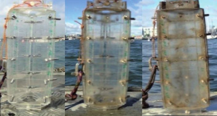
Developing a Primary Node in the National MSFD
Underwater Noise Monitoring Network

                                                                                                      NATIONAL INFRASTRUCTURE ACCESS PROGRAMME (NIAP)
Lead PI: Gerry Sutton, MaREI (formerly Coastal & Marine Research Centre),
University College Cork; Quiet Oceans and Smart Bay

Underwater noise is an important aspect of the Marine Strategy Framework Directive (MSFD),
which aims to achieve good environmental status (GES) of the European marine environment
by 2020. Noise is defined here as sound that causes negative effects. GES is defined according
to a set of 11 broad indicators or ‘descriptors’, including those focusing on biological diversity,
fish populations and marine litter. Descriptor 11 focuses on energy inputs, including underwater
noise. In February 2012, the MSFD Technical Subgroup on Underwater Noise delivered a report
to the European Commission, providing guidance on implementing aspects of the MSFD under
descriptor 11 (Van Der Graaf et al, 2012).

This project aimed to develop the first node in a proposed network of acoustic monitoring
stations that would (in conjunction with an associated package of advanced acoustic
modelling and sound scape mapping) substantially support Ireland’s national MSFD reporting
requirements for Descriptor 11.2 (continuous low frequency sound).
                                                                                                      7
The project kicked-off in May 2014 and was led by Gerry Sutton at UCC. It involved a French
company (Quiet Oceans) working with UCC in the specification and procurement, calibration,

                                                                                                      RESEARCH AND INNOVATION PROJECTS
power requirements and operational pre-testing of a high performance hydrophone for
deployment in Cork. The three parties (CMRC, Quiet Oceans and SmartBay) have been working
on the design of the integration of the selected Ocean Sonics IC-Listen hydrophone into
SmartBay’s data buoy off Cork. An innovative cabling solution has solved the issue of differential
movement, as the hydrophone is fixed at the seabed, and the Smart buoy itself is highly mobile
within the range of it’s moorings (+/- 20-30m approx). A custom built Quiet Oceans acoustic
signal processing unit mounted in the smart buoy extracts the key values relevant to Descriptor
11.2 from the large volume of incoming data arriving by Ethernet from the hydrophone, and
transmits these in compressed form to the buoy’s communication system where they are
re-transmitted ashore via 3-G and archived for subsequent use and dissemination.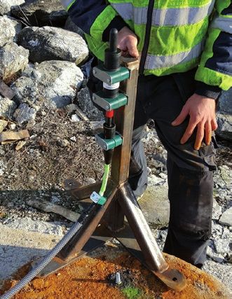
RESEARCH AND INNOVATION PROJECTS

                                                  A mounted hydrophone is fixed into a mounting            Figure: Cork Buoy being deployed off Roches Point,
                                                  frame which is bolted onto one of the two concrete       Co. Cork.
                                                  sinkers that anchor the Smartbuoy in position.
                                                  At 100m in length the Ethernet cable is operating
                                                  close to maximum limits the limit for effective
                                                  transmission of high volume acoustic data.

8
NATIONAL INFRASTRUCTURE ACCESS PROGRAMME (NIAP)
Location of submarine and intertidal groundwater
discharge to Kinvara Bay Galway, Ireland
NATIONAL INFRASTRUCTURE ACCESS PROGRAMME (NIAP)
Lead PI: Dermot Diamond, Tim McCarthy and John Cleary, Insight Centre for Data Analytics,
National Centre for Sensor Research, Dublin City University, Dublin 9, Ireland Carlow Institute of
Technology, Carlow, Ireland and National Centre for Geocomputation Ireland, Maynooth Ireland
Researchers: Margaret McCaul, Jack Barland and Conor Cahalane
Submarine and intertidal groundwater discharge (SIGD) is of increasing global significance
due to its role in transporting freshwater to the ocean as well as contaminants or nutrients.
The Western River Basin District (WRBD) and specifically the Kinvara-Gort groundwater body
(GWB) have been classified as a high risk for contamination1. The Kinvara-Gort GWB is primarily
underlain by limestone that includes large fissures, cracks, and conduits that act as preferential
flow paths for groundwater2. This project aimed to locate SIGD occurrences in Kinvara Bay using
a fusion of data collected via the Earth Observation satellite, small aircraft and in-situ sensors.
Over the course of a four day field campaign in August 2015, ~65,000 in-situ temperature and
salinity measurements were collected along with a simultaneous fly-over measuring sea
surface temperature measurements via IR thermal imaging. The processed in-situ data shown
in the figure illustrate clear gradients in temperature and salinity at the southern end of Kinvara
Bay where freshwater springs can be identified at low tide. This is supported by groundwater
9
dye tracing experiments, which identify Kinvara as the main discharge point for much of the
RESEARCH AND INNOVATION PROJECTS
Kinvara-Gort GWB3. Salinity values range from 1-2 ppt near the southern end of the bay all the
way up to 30 ppt near the mouth of the bay, indicating the presence of a freshwater wedge.
Figure: Temperature and salinity maps of Kinva.
1 Drew, D. & Chance, H. 2007. The hydrology of karst springs in the Republic of Ireland. Geological Survey of Ireland Groundwater
Newsletter, 46, 13–14. 2.Smith, A. & Cave, R. 2012.
2 Influence of fresh water, nutrients and DOC in two submarine-groundwater-fed estuaries on the west of Ireland. Science of the
Total Environment, 438, 260-270.
3 Wilson, J. & Rocha, C. 2012. Regional scale assessment of submarine groundwater discharge in Ireland combining medium
resolution satellite imagery and geochemical tracing techniques. Remote Sensing of Environment, 119, 21-34.New Infrastructure: Galway Bay Underwater Cable
The subsea observatory deployed from the ILV Granuaile.
RESEARCH AND INNOVATION PROJECTS
The Galway Bay Underwater Cabled Observatory is a project funded by Science Foundation
Ireland and represents a collaboration between the Sustainable Energy Authority of Ireland, the
Marine Institute, SmartBay Ireland, the Hydraulics and Maritime Research Centre (UCC), Dublin
City University and NUI Galway.
10
NATIONAL INFRASTRUCTURE ACCESS PROGRAMME (NIAP)
The subsea power and data cable being deployed (Spiddal pier in background) from the aft deck of the RV Celtic Explorer.The observatory consists of an underwater power and optical data cable running from a Shore
Station in Spiddal, through Spiddal pier to the National Marine Test and Demonstration Site
in Galway Bay. This cable is terminated at the test site by un underwater node that distributes
NATIONAL INFRASTRUCTURE ACCESS PROGRAMME (NIAP)
power and data links to up to 20 different consumers ranging from ocean energy conversion
devices to scientific instrumentation, underwater or at the surface, in a variety of power and
data bandwidth and protocol options that constitute an unique platform for testing technologies
or ideas, perform research or simply observe the ocean, the first of the kind in Ireland.
The project had two major milestones in April 2015, with the installation of the underwater cable
by the RV Celtic Explorer, and in August 2015, with the installation of the underwater node by the
ILV Granuaile; the expected date for entry into normal operation mode will happen before end
of 2015. Before all this an intensive and successful body of work was undertaken by the different
parties to manufacture, organise, assemble and fully test all components before deployment.
The observatory includes a set of permanent instruments that will be acquiring long time series
of multiple parameter ocean data (physical descriptors of sea water, wave and currents). In
addition to the surface based observations of meteorological conditions, this observatory will
provide researchers with a synoptic state of the ocean in the Test Site, historical data and access
to new research facilities and opportunities.
11
RESEARCH AND INNOVATION PROJECTS
The Cable End Equipment (CEE) is installed within a frame which acts as the subsea observatory.Investigation of Juvenile Salmon Migration Route and Sea
Trout Habitat Use in Galway Bay using Acoustic Telemetry
Lead PI: Jonathan Houghton, Queens University Belfast
Objectives
To investigate migration patterns of wild juvenile salmon smolts in Galway Bay using a passive
acoustic tagging array sited on the sea-bed and linked (at one node) to the Galway Bay cabled
observatory. To utilise real-time data from the tagging array to trigger an active tracking survey
using a boat mounted portable hydrophone to identify migration route preferences/habitat usage.
To provide ‘control’ data for wild juvenile salmon, and juvenile and older sea trout movement in
Galway Bay prior to the installation of the proposed finfish open cage farm. To analyse data in a
modelling framework incorporating tagged fish movement and environmental data (QUB).
Spatiotemporal statistical (Bayesian MCMC and INLA) and process-based models will be applied
to these data in order to understand drivers of fish movement at the onset of migration. Specific
reference will be made to the concept ‘energy landscapes’ within the bay, linking patterns of
residency/migration to their underlying energetic costs (derived from acoustic transmitters).
Relevance
RESEARCH AND INNOVATION PROJECTS
Atlantic salmon (Salmo salar) populations are in decline across their distribution in the North
Atlantic (ICES, 2014). Substantially reduced marine survival from the post-smolt (initial marine
stage following freshwater residency period) to the returning adult stage has been observed
over the past decade (SSCS, 2014). Juvenile stages (i.e. post-smolt) are the most vulnerable
with up to 75% mortality observed in the first few weeks at sea in North American waters
(IASRB, 2015). Identifying the presence, timing and location of survival bottlenecks for salmon
at sea is a research priority (IASRB, 2015) and monitoring salmon in their early migration as
they progress through their migration routes to (and from) their distant marine feeding areas
(Faroes or Greenland), and, ultimately, to estimate stage/area-specific mortality, will provide an
understanding of the factors affecting marine mortality in particular areas and at specific times.
12 Little is known about the distribution, movement and feeding migrations of sea trout, the
migratory form of Salmo trutta, in marine waters around the west coast of Ireland where,
since the late 1980s, severe stock declines have been observed in Irish rod fisheries (Gargan
et al, 2003). Increased sea-lice mediated mortality in coastal waters is a feature of sea trout
NATIONAL INFRASTRUCTURE ACCESS PROGRAMME (NIAP)
populations where intensive salmonid marine fish farming is carried out (Thorstad et al, 2014)
and the potential impact of a large salmon production unit in Galway Bay has identified a
shortfall in information about marine habitat usage by sea trout within the bay.
Improved knowledge of the distribution and migration patterns of juvenile salmon and sea
trout in Galway Bay will contribute towards refining understanding of natural, environmental
or anthropogenic risk factors to distant (salmon) and local (sea trout) migrants in the marine
phase of their anadromous life cycles.
The project connects QUB’s modelling and biotelemetry skills and Inland Fisheries Ireland’s
research goals with advanced in-situ technology, in a challenging sampling environment,
addressing identified international, national and local research needs for both species and is
a good fit with NIAP Fisheries Research theme particularly fish stock monitoring and methods
development for observing fish stocks.Galway Bay Biogeochemical Time Series (GALBAY):
Seasonal cycles of CDOM and Synechococcus
NATIONAL INFRASTRUCTURE ACCESS PROGRAMME (NIAP)
Abundance in Galway Bay
Lead PI: Peter Croot, National University of Ireland Galway
Objectives
The proposed project seeks to establish NUIG’s research into marine biogeochemical
cycles as an ‘anchor’ tenant of the SmartBay test facility located near Spiddal in Galway
Bay. Thus ongoing and future research would be built around the continuation of the time
series established at this location and it would be used as a crossover station for all work
performed along the west coast of Ireland for which ships transit into or out of Galway Bay.
The sensor package chosen for this initial stage are designed to look at two key parameters
for understanding microbial and carbon cycling with Galway Bay over daily, seasonal and annual
cycles. This project has a number of short term and long term goals that it will address during
both the initial stage of this project and into the future.
13
RESEARCH AND INNOVATION PROJECTSShort term goals
1) To obtain data over diel periods and the seasonal cycle for the abundance of
Synechococcus in Galway Bay as determined by the in situ phycoerythrin fluorescence
signal.
2) Determine the contribution of picoplankton (Synechococcus) to the overall chlorophyll
signal in Galway Bay over a seasonal cycle.
3) To obtain data over tidal and seasonal cycles for CDOM fluorescence and relate the
observed signals to fluvial or phytoplankton inputs by comparison to other hydrological and
biogeochemical parameters measured at the same time at the Spiddal site.
Long term goal
1) To monitor changes in the abundance of Synechococcus and the intensity of CDOM
fluorescence over inter-annual and decadal scales to examine the influence of natural
(e.g. NAO) and anthropogenic induced climate change on these biogeochemical parameters.
Relevance
The proposed project is an excellent fit within the ongoing vision of SmartBay as it will allow the
further development and application of sensors for biogeochemical monitoring and research
RESEARCH AND INNOVATION PROJECTS
within the existing setup of the Spiddal test facility. In obtaining a set of baseline data using
a combination of existing sensor technologies and conventional discrete sampling methods
it will allow new sensors to be calibrated and validated in the same environment. Finally by
embedding the collection of biogeochemical time series data within the functions of the test
facility it will ensure that there are strong research questions driving aspects of the research
undertaken there.
14
NATIONAL INFRASTRUCTURE ACCESS PROGRAMME (NIAP)Antifouling Strategies for Marine Deployed Structures
Dublin City University
NATIONAL INFRASTRUCTURE ACCESS PROGRAMME (NIAP)
Lead PI: Fiona Regan
Researchers: Alan Barrett, Sandra Kwiatkowska
Objectives
The project starting in 2015 aims to deploy and test a number of developed nanotechnology-
based antifouling (AF) materials for prevention and reduction of the impacts of biofouling. The
AF materials including copper-based superhydrophobic coatings, nanoparticle-doped solgel
coatings and functionalised materials are being deployed on commercial marine water quality
sensors, solar panels or mooring tethers. The performance of a self-cleaning coating on solar
panels and its ability to reduce the impact fouling has on energy production will be assessed.
This aim will be achieved by a strong focus upon industry-specific application requirements –
for example through collaboration with Technology from Ideas (TFI). Both novel and existing
technology will be integrated into complete AF solutions compatible and complementary to
existing components such as anticorrosion material.
Relevance 15
Any object that is immersed within a water environment will undergo biofilm formation within
minutes. In the case of sensors, biofilm formation can have an immediate deleterious effect
RESEARCH AND INNOVATION PROJECTS
on data quality and therefore the sensors will require improved maintenance to restore and
improve data integrity. This project addresses the need for effective antifouling (AF) materials
to combat biofouling on infrastructure or sensors in the marine environment. This is a
multidisciplinary and collaborative project; SmartBay will utilise the AF strategies proposed in
this work. Initially materials are tested in Dublin Bay for up to 2 months. (figure 1) Results of
deployments in Dublin Bay are used to select suitable materials for deployment in SmartBay.
Figure 2 illustrates the deployment panels used for initial testing in the aquatic environment.
Figure 1: Deployment site, Poolbeg marina in Dublin city Ireland.Figure 2: Fouling assessment on coated glass substrates in an estuarine environment for 3 weeks in Dublin Bay
(Summer 2015).
RESEARCH AND INNOVATION PROJECTS
It is in the interest of SmartBay to have up to date knowledge of antifouling technologies,
particularly while they are developing out the ocean observation test bed in Galway Bay. The
knowledge will benefit all future users of the infrastructure also. There is plenty of opportunity
to apply successful antifouling materials identified in this project in other novel devices and
technology. There are very few areas of marine research not limited by fouling and so the
development of effective antifouling would be of great benefit. The project will focus on the real
world functionality of antifouling material in the marine environment, including adaption to
sensors, deployments, dissemination of findings and exploitation of intellectual property.
In particular for sensor-based applications, by combining expertise on non-toxic AF material
16 development, industrial participation, commercialisation and nanotechnology, this project
will develop next-generation AF solutions that are environmentally friendly, effective, and
commercially available through mass production. Figure 3 illustrates a self cleaning coating
NATIONAL INFRASTRUCTURE ACCESS PROGRAMME (NIAP)
that will be applied to solar panels on the Galway Bay buoy.
Figure 3: The flexible coating on a PET sheet suitable for application to solar panels.Monitoring the Impact of renewable energy devices on
small coastal cetaceans through coastal monitoring
NATIONAL INFRASTRUCTURE ACCESS PROGRAMME (NIAP)
Lead PI: Joanne O’Brien, Galway/Mayo IT
Objectives
The proposed project aims to use the SmartBay infrastructure (OceanSonics icListen high
frequency hydrophone) to collect acoustic information on small coastal cetaceans occurring at
the SmartBay site off Spiddal, Co. Galway. This hydrophone unit was deployed and is currently
maintained by the Marine Institute; data collected by the hydrophone will be tested and analysed
to assess its capacity of detection of coastal cetaceans (most likely harbor porpoise and dolphin
species).
Additional acoustic data will be acquired at this time through the use of C-PODs (similar to
what is carried out under a smaller NIAP1 project). C-PODs are static acoustic monitoring
instruments that detect toothed whales, dolphins and porpoises by identifying the trains of
echo-location sounds they produce. This additional method of data collection will help to identify
time of occurrence and will serve as a comparison to the hydrophone method of collection.
17
Relevance
There is little research carried out across Europe to test the effect of renewable energy devices
RESEARCH AND INNOVATION PROJECTS
on cetacean presence as few sites are accessible. This research will serve to inform future
development of renewable energy around the Irish coast but also on an international level.
Another element to this project will be to undertake noise measurements when prototype
devices are operational but also in their absence. This noise acquisition and analyses will be
carried out in collaboration with Marshall Day Acoustics, who already have an established
partnership with GMIT through the FUSION programme. Marshall Day will use their newly
designed software dBSea to generate these noise measurements and provide empirical data on
the operational noise levels of prototype devices, something which will be extremely important
over the planning stages and deployment of these devices. This approach will allow for an
assessment of the soundscape of the site to be carried out both during and in the absence of
operational devices, and therefore assessing their impact on the overall environment.The impact of marine renewable energy devices on marine mammals is not known. There
has been considerable interest recently on the potential effects with a number of useful and
extensive reviews published (e.g. Inger et al 2009; Boehlert and Gill 2010). However with a lack
of working devices deployed in the marine environment with which to test these hypotheses,
inevitably there is much speculation, with very little empirical data to inform these debates.
This proposed work will serve to use SmartBay infrastructure but will also allow for the buildup
knowledge of the potential positives and negatives of these devices in the marine environment
and will serve to generate noise measurements associated operational units.
RESEARCH AND INNOVATION PROJECTS
Figure: Galway Buoy deployed within the test site (looking South with the Burren in the background).
This project commenced in October 2015, and aims to use the SmartBay infrastructure
18 (OceanSonics icListen hydrophone) to collect acoustic information on small coastal cetaceans
occurring at the SmartBay site but also to monitor noise levels at the site prior to the
deployment of OE devices for testing. Additional acoustic data will be acquired through the use
of C-PODs (similar to what is carried out under a NIAP1 project). This additional method of data
NATIONAL INFRASTRUCTURE ACCESS PROGRAMME (NIAP)
collection will help to identify time of occurrence of harbour porpoises and dolphin species,
and will serve as a comparison to the hydrophone method of data collection for cetaceans. Data
analyses of raw acoustic files (wav.files) is very labour intensive so having indicators of times of
occurrence from the C-PODs will help with data analyses. Noise modelling will be carried out by
Marshall Day Acoustics in Northern Ireland who are partners on this project. Additionally, noise
data collected under this programme will be used by Marshall Day to help verify a new software
programme they have developed called dBSea. This approach will allow for an assessment
of the soundscape of the site to be carried out both during and in the absence of operational
devices, and therefore assessing their impact on the overall environment. The impact of marine
renewable energy devices on marine mammals is not known, and hence the growing interest
recently resulting in published reviews (e.g. Inger et al 2009; Boehlert and Gill, 2010). However
due to a lack of working devices deployed in the marine environment, there is unsurprisingly
much speculation, and very little empirical data to inform these considerations.RAFTS (RAinFall aT Sea)
Lead PI: Sheena Fennell, National University of Ireland Galway
NATIONAL INFRASTRUCTURE ACCESS PROGRAMME (NIAP)
RAFTS is a pilot project using SmartBay infrastructure which aims to provide better estimates
of the quantity of rain falling at sea by collecting simultaneous data at sea and from land based
stations. The project has three objectives: to look at the effects on stratification, to examine the
influence rain water has on bringing nutrients into the upper ocean, and to investigate whether
it would be viable or possible to harvest rainwater at sea for the aquaculture industry on site to
use for lice infestations.
19
RESEARCH AND INNOVATION PROJECTS
A simple rain collector was constructed for the RAFTS project and tested on the SmartBay buoy
off Spiddal in March 2015. The first aim was to collect rainwater uncontaminated by sea spray.
Conductivity measurements from the first deployment proved this to be the case. Following this
successful test, an identical collector was installed at the NUIG weather station on the roof of
one of the NUIG campus buildings. Between June and October 2015 the RAFTS rain collector
was calibrated against the NUIG IRUSE tipping bucket rain gauge. This involved emptying the
RAFTS rain gauge weekly and measuring the volume collected, and comparing this to the
volume over same period recorded by the IRUSE system. Very good agreement was observed,
with the RAFTS system collecting slightly more rain (~5%) than was recorded by the IRUSE
system.On 7th August 2015 the SmartBay buoy was redeployed off Spiddal with the RAFTS rain collector.
Two further RAFTS rain collectors were installed on Inisheer lighthouse on the same day, with
the permission of the Commissioners of Irish Lights, and the RAFTS collector at NUIG was
emptied. On 15th September, the rain collectors from the SmartBay buoy, Inisheer lighthouse
and NUIG were simultaneously emptied and measured. Conductivity again showed no sea spray
contamination. The SmartBay collector and the collector on the SW side of Inisheer lighthouse
collected almost identical volumes of rain (1225ml and 1255ml respectively), while the collector
on the NW side collected higher rain (1785ml), and the NUIG systems almost twice as much
(3795ml).
Averaging the three marine based rain collectors and taking that value to be representative
of rain falling on a bay area of 552km2 (inner bay to a line just west of Inisheer) yielded a total
rainfall volume over Galway Bay of 18.5 x 10⁶ m3 during the period. This represents 14% of the
estimated average flow of the R Corrib for the same period, indicating that direct rainfall is
significant source of fresh water to Galway bay. Further, the difference in rainfall collected by
the marine based collectors and the NUIG land-based station indicates that land-based stations
are not representative of rainfall over coastal waters.
RESEARCH AND INNOVATION PROJECTS
20
NATIONAL INFRASTRUCTURE ACCESS PROGRAMME (NIAP)NATIONAL INFRASTRUCTURE ACCESS PROGRAMME (NIAP)
Ollscoil Chathair Bhaile Átha Cliath
Dublin City University
Contact Details
Prof. Fiona Regan
NIAP Co-ordinator
Director, Marine and Environmental Sensing Technology Hub (MESTECH)
Dublin City University, Glasnevin, Dublin 9 21
Fiona.regan@dcu.ie
+ 353 1 7005765
RESEARCH AND INNOVATION PROJECTS
www.smartbay.ie
Joan Kelly
SmartBay Administrator
Dublin City University, Glasnevin, Dublin 9
joan.kelly@dcu.ie
+353 7007856SmartBay Ireland is funded under the Programme for Research in Third-Level
Institutions (PRTLI) Cycle 5 with collaborating partners including:
An Roinn Post, Fiontar agus Nuálaíochta
Department of Jobs, Enterprise and InnovationYou can also read