NEWLYN HARBOUR: Historical Developments from Favoured Landing Beach to Premier Fishing Harbour - Maritime Archaeology Trust
←
→
Page content transcription
If your browser does not render page correctly, please read the page content below
Newlyn Harbour: Historical Developments
___________________________________________________________________________________________________________

                   NEWLYN HARBOUR:
     Historical Developments from Favoured Landing
             Beach to Premier Fishing Harbour

                            August 1932 – Newlyn Harbour and Town Looking North West
                                        The Old Quay, South and North Piers
                               (Source: https://www.britainfromabove.org.uk/en/image/EPW039842 )

Researched and compiled by Maritime Archaeology Trust Volunteer Roger Burns                           1 of 19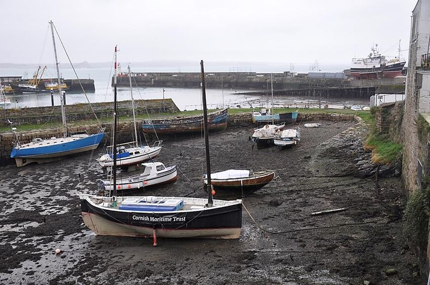
Newlyn Harbour: Historical Developments
___________________________________________________________________________________________________________

                                                             NEWLYN HARBOUR
           Historical Developments from Favoured Landing Beach to Premier Fishing Harbour

Contents
   Acknowledgments .................................................................................................................................... 2
   Introduction ............................................................................................................................................. 3
   Location ................................................................................................................................................... 3
   Geology and related characteristics .......................................................................................................... 4
   Storms and Surges .................................................................................................................................... 4
   Newlyn Harbour – The Old Quay and Fishing ............................................................................................ 5
   Newlyn Harbour – The South Pier – the 1st & 4th Contracts ....................................................................... 6
   Newlyn Harbour – The North Pier – the 2nd & 3rd Contracts ...................................................................... 7
   Newlyn Harbour – Mid 1900’s .................................................................................................................. 8
   Newlyn Harbour – The Slipway and Cradle ............................................................................................... 9
   Newlyn Harbour – The Trawl Pier and the Mary Williams Pier ................................................................ 10
   Newlyn Harbour – The War Years ........................................................................................................... 10
   Newlyn Harbour – Dredging, RNLI, Industry and Infrastructure ............................................................... 11
   The Tidal Observatory ............................................................................................................................ 12
   Conclusions and Summary ...................................................................................................................... 13
   Bibliography ........................................................................................................................................... 13
   Appendix A – Newlyn Storm 7 March 1962 ............................................................................................. 14
   Appendix B – Proposed New Harbour at Newlyn, 1865 ........................................................................... 15
   Appendix C – Completion of the South Pier ............................................................................................ 15
   Appendix D – Completion of the North Pier ............................................................................................ 17
   Appendix E – Completion of South Pier Extensions ................................................................................. 19

Figure 1: Newlyn Location Plan.................................................................................................................... 3
Figure 2: The Old Quay at Low Water - 2020 ............................................................................................... 6
Figure 3: South Pier - Cross Section ............................................................................................................. 7
Figure 4: North Pier – Cross Sections ........................................................................................................... 8
Figure 5: Newlyn Harbour in 1907 ............................................................................................................... 9
Figure 6: The Old Quay with Slipway and Cradle Beyond - Low Water 2020 South Pier with Lighthouse in
  Background ............................................................................................................................................. 10
Figure 7: Steam Locomotive with Tipper Wagons 1906 ............................................................................. 12
Figure 8: Stone Boat Loading by Conveyor - 1975 ...................................................................................... 12

Acknowledgments

The help of the Newlyn Archive is gratefully acknowledged in providing background material for this
narrative. Permission to use construction and survey extracts from the library of the Institution of Civil
Engineers is also duly acknowledged.

Researched and compiled by Maritime Archaeology Trust Volunteer Roger Burns                                                                              2 of 19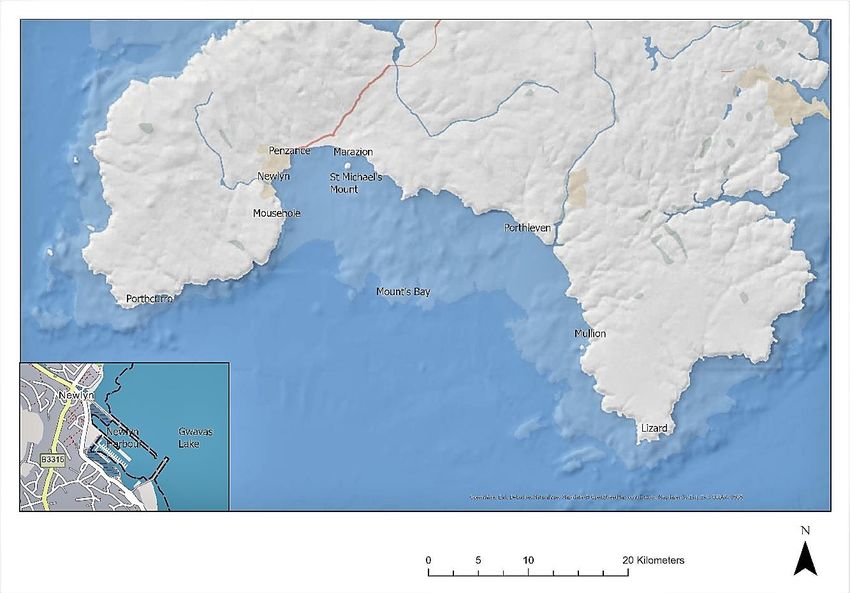
Newlyn Harbour: Historical Developments
___________________________________________________________________________________________________________

Introduction
The MAT are partners in the EU Funded Sustainable and Resilient Coastal Cities project SARCC which includes
a Pilot Study area at Newlyn where the design and construction of an eco-reef aims to create a nature-based
solution to minimise coastline damage against surges and rising sea levels. The MAT’s involvement includes
examining how evidence from archaeology, art, historic photographs, maps and charts can provide a long-
term understanding of changes to the coast to help with planning for the future. The Newlyn Pilot area is
located immediately to the west of the river Coombe outfall, adjacent to the harbour’s North Pier. Find out
more about the Newlyn Pilot project here.

Consequently, MAT volunteer Roger Burns has been inspired to look in more detail at the history and
development of Newlyn Harbour. A selection of significant storm and tsunami events which predate and
postdate the modern harbour development is listed, as is the importance of the Newlyn Tidal Observatory
incorporated into the South Pier and which is fundamental to the survey levelling of mainland Britain. The
construction and use of the modern harbour piers are highlighted which together have contributed to
Newlyn’s premier position as a fishing harbour of importance. Mention is also made of boat building carried
on at Newlyn. Newlyn Harbour dates back to before 1337 but it was late in the 19th century before
construction of the harbour as we know it today started. This article looks at the setting of Newlyn’s location,
the history including fishing and construction of the present harbour with associated infrastructure.

Location
Newlyn nestles on the eastern coast of the Penwith peninsula, within Mount’s Bay which embraces the
western extremity of the English Channel north of a line between Porthcurno and the Lizard, depicted in
Figure 1.

                                                Figure 1: Newlyn Location Plan

Penzance is a conurbation just to the north-east of Newlyn, in the commercial centre of the area and its civil
parish includes Newlyn. Immediately adjacent to the modern Newlyn harbour is Gwavas Lake, an area of
relatively calm water within Mount’s Bay which originally led to Newlyn fishermen landing their catches
there.

Researched and compiled by Maritime Archaeology Trust Volunteer Roger Burns                               3 of 19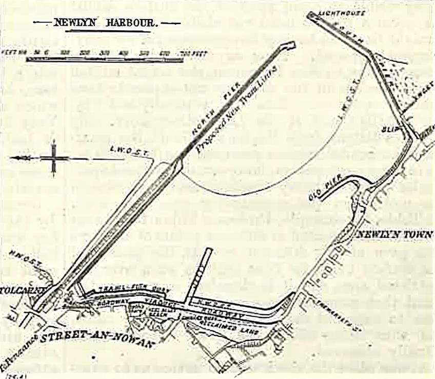
Newlyn Harbour: Historical Developments
___________________________________________________________________________________________________________

Geology and related characteristics
The British Geological Society 1:50,000 scale mapping shows superficial marine deposits of sand and gravel
especially along the north shore of the Bay, overlying the Mylor Slate formation, Hornfelsed slate and
Hornfelsed siltstone. Just to the south of the harbour, there is an igneous intrusion of Devonian Gabbro and
Microgabbro. The north-east and eastern coastlines of Mount’s Bay display a wide variety of deposits. The
Penwith peninsula is Land’s End granite bedrock detailed as Carboniferous to Permian - Felsic-Rock .

Just to the south of Newlyn is Penlee Quarry which is now a Site of Special Scientific Interest and which
utilised Newlyn harbour to export arisings, as described below. Granite was used in Newlyn harbour
construction. Removal of overburden during workings were used with other quarry output in construction of
the First World War Royal Naval Air Station adjacent to the quarry.

Storms and Surges
Newlyn’s location, as seen above, is sheltered except when prevailing winds from the south and particularly
the south-east prevail, and this led to the construction of a harbour at Newlyn, initially in the 14th century
and later ‘Old Quay’, and then in the 19th century the ‘Modern Harbour’. But first, it is pertinent to catalogue
a brief selection of significant storms and surges. (Those events with a BGS reference are considered by the
BGS to be Tsunami events. Other events are storms). Key dates for the modern harbour construction time
line within the following selection are noted.
   • 25 November 1738 – “Severe storm when the weather was hard, stormy, and thick and a very great
       sea broke down a great part of the Newlyn Quay” [NA: 1]. The original quay was built prior to 1337
       [NA: 2].
   • 1 November 1755 – The Mount’s Bay Tsunami, arising from the “Lisbon Earthquake” which together
       with the resulting tsunami killed between 60,000 and 100,000 [BGS Report CR/07/077: A].
   • 31 March 1761 – Resulting from a tsunami, widely observed including a detailed account in Mount’s
       Bay, with references at St. Michael’s Mount, Penzance pier, Newlyn, Mousehole pier, and Scilly [BGS
       Report CR/07/077: B].
   • 10 October 1809 and 8 November 1809 – Loss of 11 vessels near Newlyn [NA: 3].
   • 23 May 1847 – rises and falls of sea level between 0.9 and 1.5m in Mount’s Bay [BGS Report CR/07/077:
       C].
   • 4 October 1859 – Reported in the Royal Cornwall Gazette of 7 October 1859. “An Extraordinary Tidal
       Wave, or series of waves, swept into the Mount's Bay on Tuesday about half-past six in the morning,
       and the alternate rise and fall of the sea was watched by many spectators until noon. The first wave
       must have swept into Penzance harbour at least five feet deep, much to the discomfiture of various
       craft. Several vessels broke adrift; the large buoys at the entrance of the harbour were submerged, a
       raft of timber and a barge were carried out by the receding wave, and altogether the unexpected visitor
       caused much commotion. On the Western shore of the Bay this tide was felt in full force at Newlyn and
       Mousehole, but we have received no account from the Eastern side”.
   • 29 September 1869 – Reported in the Hampshire Independent of 2 October 1869. “A remarkable tidal
       phenomenon was witnessed on the western coasts on Wednesday, when in several of the small
       harbours the tide rushed at the rate of five or six miles an hour, and then receded again as rapidly. The
       rise and fall amounted to five or six feet. Fortunately, it was a neap tide, or serious results might have
       followed. The run of the sea on the beach at Newlyn was from 90 to 100 feet”. (c.27.4m to 30.5m). The
       BGS dismissed this as tsunami event.
   • 7 October 1880 – Reported in the Western Morning News of 8 October 1880. “A fearful storm occurred
       during Wednesday night and yesterday morning on the south-west coasts. Penzance suffered most
       severely, seven lives being lost by the foundering of a fishing boat, and the casualties among shipping
       being many and serious. At Salcombe, the master of a ship was washed overboard, and at Newlyn no
       less than eight fishing boats have been sunk. Plymouth also experienced the gale, though to less
       extent”. The storm, with resultant liabilities bankrupted the Mount’s Bay Insurance Club [NA: 4] and

Researched and compiled by Maritime Archaeology Trust Volunteer Roger Burns                                4 of 19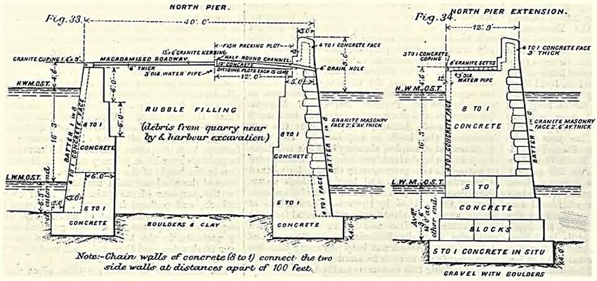
Newlyn Harbour: Historical Developments
___________________________________________________________________________________________________________
this led to a Storm Relief Fund for the fishermen of Mount’s Bay who sustained losses in October. The
fund totalled £1,754 and 5d (circa £ 216k in 2020) and the accounts, contributors and beneficiaries
were extensively reported over 4½ columns in the Cornish Telegraph of 6 January 1881.
• The South then North Piers of the Modern Harbour were constructed between 1885 and 1894.
• 26 January 1917 – The Cornishman of 1 February 1917 included the following report. “THE GALE.
HEAVY SEAS IN MOUNT'S BAY. A heavy gale from the south-east has been blowing since Thursday, and
tremendous seas have been running in Mount's Bay. On Friday, at one period, there seemed have been
some diminution, but the wind rose again on Friday night, and on Saturday, the gale was raging with
even greater intensity. No great material damage, however, has been reported, though that portion of
the inhabitants who reside in the Wherrytown district have suffered considerable personal
inconvenience. With each tide, the sea has come up and flooded their premises. People going to and
from Newlyn have had to take the path through the fields, the water in the road between the eastern
end of the Baths and Laregan river being several inches deep. The Tolcarne Inn at Newlyn also has felt
the full effects of the gale, being flooded a considerable depth. Probably never since the houses were
built, have the inhabitants of Lanoweth terrace had such an experience, the sea, it is said, coming up
against their front door. The work at the railway station was retarded at certain states of the tides”.
Wherrytown and Lanoweth are in Penzance, and the river Laregan (contemporaneous spelling)
discharges at Wherrytown 500m east of Coombe river, Newlyn. This storm also resulted in the loss of
Hallsands village (https://maritimearchaeologytrust.org/3407-2/) .
• 25 November 1941 – An earthquake west of Portugal resulted in an observation at Newlyn of “seven
waves with a maximum amplitude of about 20cm and lasted about four hours” [BGS Report CR/07/077:
D].
• 23 May 1960 – 9.6 earthquake at Chile on 22 May 1960 with sea level influence recorded at Newlyn
the next day [BGS Report CR/07/077: E].
• 7 March 1962 – This storm was reported by several newspapers as the worst storm in living memory
which affected particularly Newlyn and Penzance, one such report is included in Appendix A. At
Newlyn, the Harbour offices were almost breached. The storm unleashed itself on top of a flood tide
[NA:4] followed by flooding from heavy rain.
• 28 February 1969 – Recorded at Newlyn from an earthquake west of Portugal evidenced by seiching
sea levels on an otherwise calm day [BGS Report CR/07/077: F].
• 26 May 1975 – Yet another earthquake west of Portugal with tsunami consisting at Newlyn of “eight
waves with a maximum amplitude of about 6cm lasting nearly four hours” [BGS Report CR/07/077: G].
• 27 October 2004 – a YouTube of the storm mostly outside the harbour.
• A YouTube dated 11 March 2008, storm breaking over the South Pier.
Newlyn Harbour – The Old Quay and Fishing
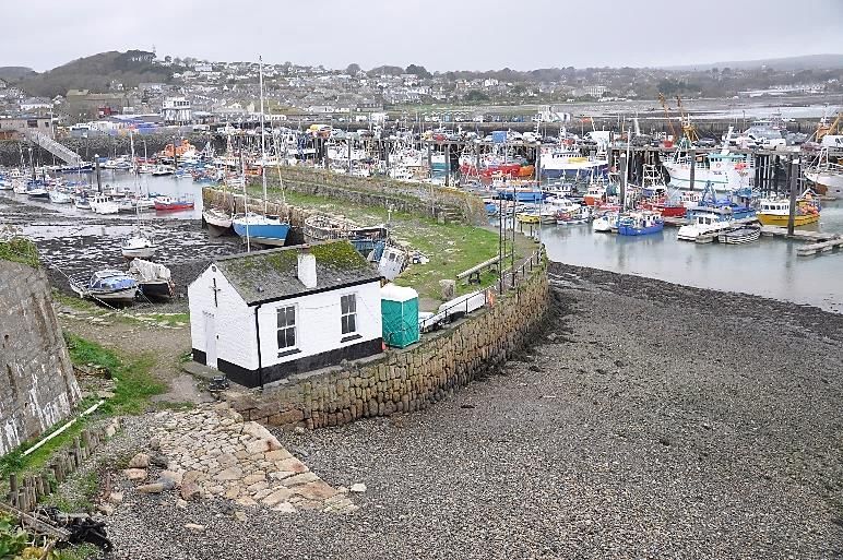
The Old Quay dates back to 1337 or earlier and consists as shown in its modern setting, Figure 2, of an
unjointed granite block curved wall with parapet some 300 ft. (c. 91m) long. The old Medieval Quay was
rebuilt and extended in 1732 and much of the structure shown in Figure 2 is likely to be 18th century, but is
thought to include the older structure within in. The Newlyn Old Quay gave protection to some 40 small
vessels, other vessels needing to shelter would have used the headlands or made for Penzance whose
harbour dates from 1512 [NA: 5]. The Newlyn Old Quay was 5yds (c.4.6m) wide and water depth at High
Water OS was average 6ft (c.1.82m). [I.C.E.:1] Both Penzance and Newlyn were “places to land fish” which
originally would have been the respective beaches. Newlyn was well established with fishing back in 1814,
with road connections as described by “From Penzance, a carriage-road (not turnpike) proceeds to the Land's-
end (eleven miles); leaving the church-towns of Maddern and Sancreet, with the populous village and church
of St. Just, to the right; the great fishing-coves of Newlyn and Mousehole, the church of St. Paul, and the
church-town of Burian, to the left” [BHO]. The harbour was always dry at low water.
Researched and compiled by Maritime Archaeology Trust Volunteer Roger Burns 5 of 19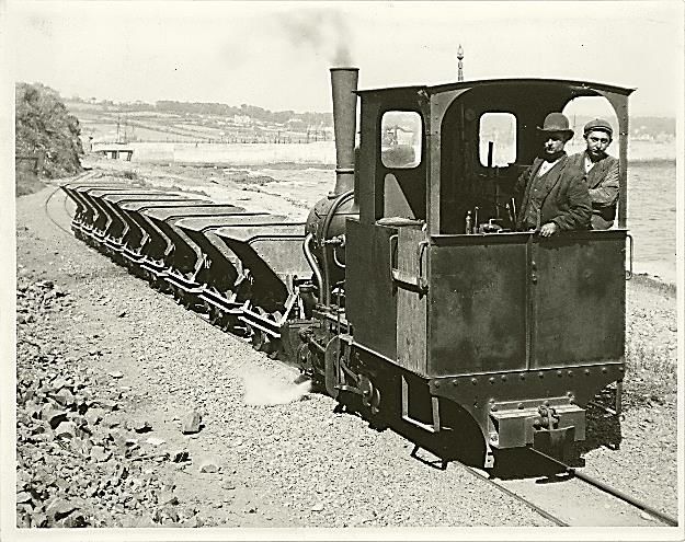
Newlyn Harbour: Historical Developments
___________________________________________________________________________________________________________

                                                                              Pilchard fishing was a mainstay for
                                                                              Newlyn and Cornwall generally since
                                                                              1555 when exports were first
                                                                              recorded but overfishing and
                                                                              reduced market opportunities saw a
                                                                              decline by the 1960’s. Pilchard fishing
                                                                              had a vibrant export market to Italy
                                                                              which endured between 1555 and
                                                                              2005. In 1905, the Pilchard Works
                                                                              started, more information can be
                                                                              read here.

                                                                        Prior to the nineteenth century, only
                                                                        the area around the Old Quay was
                                                                        known as 'Newlyn' whereas the area
                                                                        of the town where the fish market is
                                                                        situated was known as 'Street-An-
                  Figure 2: The Old Quay at Low Water - 2020            Nowan'. At high tide 'Street-An-
                                                                        Nowan' was separated from 'Newlyn
Town'. The lower part of the area around the modern harbour is built on land that was a beach and reclaimed
from the sea, involving overburden from Penlee Quarry in substantial quantity intermixed with large lumps
of granite, and finished with a viaduct on piles connecting the two localities by road, completed in late 1908
[NA: 6].

The rail infrastructure was extended to Penzance in 1852 which helped to boost the fish trade at Newlyn as
landings could be more quickly transported via Penzance to markets with large demand. Initially, Penzance
in 1846 was a terminus for the West Cornwall Redruth line and shortly afterwards with Truro, and to London
by changing trains as gauges were different. The link to Plymouth was opened in May 1859.

Newlyn Harbour – The South Pier – the 1st & 4th Contracts
By 1883, it was clear that the Old Quay was too small for the then fishing fleet, especially during low water
[NA: 7]. But similar sentiments had started well before this, in 1865 (see Appendix B). Up until 1873 a number
of petitions for building the harbour were presented to the relevant authorities but Penzance, feeling
threatened by such a close-by competitor, successfully objected. One proposal gained Board of Trade
approval as reported in the Cornish Telegraph of 30 July 1873 but was allowed to expire. Matters came to a
head as the fishing boats gradually grew larger, and the storm of October 1880 was persuasive in resolving
that a harbour be built. Accordingly, plans were resubmitted and on 14 December 1884, the Engineer for the
new harbour, Mr. James C. Inglis M. Inst. C.E. of Plymouth attended a meeting of the Newlyn Harbour
Commissioners, as reported in the Cornishman of 18 December 1884, noting that 11 tenders had been
received, most within estimate and from “mostly well-known and responsible firms”. By this time, the
fisherman had a staunch ally in Mr Thomas Bedford Bolitho who in 1884 was appointed High Sherriff of
Cornwall and was elected President of the West Cornwall Fisheries Exhibition and Bazaar for the Newlyn Pier.
His cousin, Thomas Simon Bolitho loaned £12,000 and the local bank loaned £15,000 towards the cost [NA:
8].

Mr Charles Campbell Ross the MP for St Ives on 29 June 1885 laid the foundation stone of the new South Pier
at Newlyn, signalling the start of building work. The contractor was Messrs Hill and Lester of London and
Plymouth who completed the work early in 1887. The South Pier was essentially a breakwater, 707 ft
(c.215.5m) long, 25 ft (c.7.62m) wide with 20 ft. (c.6.1m) paved access, commencing just above low water
mark and at its head running into 14 ft (c.4.27m) at low water as shown in Figure 3. Construction was in-situ

Researched and compiled by Maritime Archaeology Trust Volunteer Roger Burns                                    6 of 19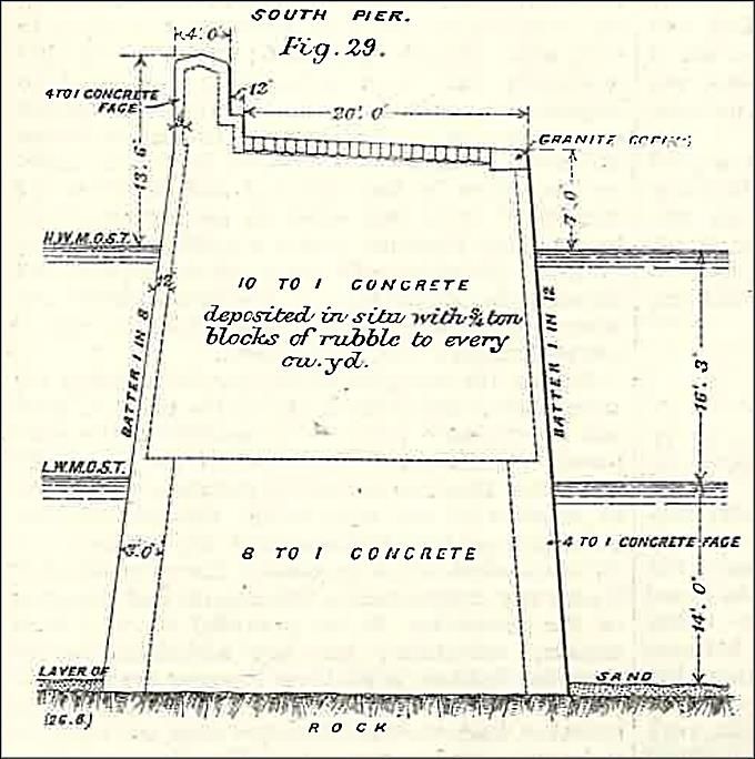
Newlyn Harbour: Historical Developments
___________________________________________________________________________________________________________

concrete with heavy granite “plums” within the concrete hearting, all founded on rock shelved out to receive
the concrete. Facings and steps were granite, and completed with a parapet on the seaward side [I.C.E.: 2].

                                                                              Reference to the first lighthouse on the
                                                                              South Pier is included in Appendix C
                                                                              which      details    the     substantial
                                                                              completion of this phase of the harbour
                                                                              construction in January 1887. Shortly
                                                                              after, the Cornishman of 17 March 1887
                                                                              reported that very low tides presented
                                                                              the opportunity to remove some of the
                                                                              rocky or rough bed of the harbour. The
                                                                              public opening of the lighthouse was
                                                                              held on 20 March 1887 when the
                                                                              occulting light was commissioned.

                                                                      The Newlyn Pier and Harbour Order
                                                                      1884 for the South Pier had authorised
                                                                      a pier 760 ft. (c.231.6m) long. After the
                                                                      North Pier had been built, the South
                                                                      Pier was extended but this required
                                                                      significant funding and plans took time
                      Figure 3: South Pier - Cross Section            to crystalise, which was the 4th harbour
                Source: Courtesy I.C.E.: 2. See Bibliography
                                                                      contract. This followed from a
realisation that better protection within the harbour against south-east storms was needed as the then width
of the harbour entrance between South and North Piers was considered excessive. Construction commenced
in early 1913 but was phased partly due to adverse weather but also to accommodate by agreement between
the Newlyn Harbour Commissioners and the Ordnance Survey a Tidal Observatory with stilling well within
the pier. The South Pier extension was 100 ft (c.30.5m) and was completed in 1915, as reported in Appendix
E and resulted in the harbour entrance being 150 ft (c.45.7m) wide. The Tidal Observatory is a Listed Building,
Grade II as of 11 December 2018. A replacement lighthouse was erected at the end of the pier extension,
with two lighthouses until 1918 when the first which had served as a lookout tower for the pilots was
dismantled, as mentioned in Appendix E. The light was electrified in 1935, and the iron structure requires
maintenance against environmental effects. The South Pier was allocated for stone and similar cargoes,
whereas the North Pier was used exclusively for fishing vessels. Note that the overall South Pier length in
records is quoted both by including the quay from the original slipway and is also quoted from the change of
direction in the quay to the extremity.

Newlyn Harbour – The North Pier – the 2nd & 3rd Contracts
Before the South Pier was extended, the need for a North Pier was readily apparent for protection against
storms in Mount’s Bay. Construction commenced on 8 March 1888 and was completed within one year. This
contract, the 2nd for the harbour, provided for a pier 1025ft (c. 312.4m) long and 10ft (c.3.05m) wide. During
construction, as reported by the Cornubian and Redruth Times of 28 September 1888, a vein of tin was struck
and a quantity of tinstone was included in the pier structure. Some realignment was needed of the Coombe
river at its discharge and armour stone was placed to divert river water away from the toe of the new pier. A
3rd contract was necessary to afford more shelter against southerly and south-easterly storms, because the
harbour entrance after the first two contracts was too wide, and it commenced in 1891, being finished in
1893. Contract detail was 890 ft (c.271.3m) with a roadway of 9ft (c.2.74m). Funding pressure had
necessitated a slimmer section, and the 3rd harbour contract, to widen the first part of the North Pier and
extend the pier towards the South Pier was undertaken. The resultant pier was 40ft (c.12.2m) wide at the

Researched and compiled by Maritime Archaeology Trust Volunteer Roger Burns                                      7 of 19
Newlyn Harbour: Historical Developments
___________________________________________________________________________________________________________
shore end, narrowing to 12 ft (c.3.66m) overall at the far end. Armour stone was placed along the whole
seaward side to protect against scour. During construction of the 3rd contract, “……the presence of a bog
patch of great depth about two-thirds of the way along the extension. In bridging this patch a slight
settlement took place in the wall, and in order to counterbalance the weight of the latter, the Engineer had
several thousand tons of rubble tipped on the seaward side, which had the desired effect of preventing further
movement”. [I.C.E.:3] Note that there are differences as reported in the length of the North Pier, and this is
thought to be from the extension contract including both the widened section of the original and the actual
extension. The completion of the North Pier was occasioned by speeches and children singing (Appendix D).
The finished pier is 1,450 ft (c.442m) long and the indicative cross-sections are shown in Figure 4.
Figure 4: North Pier – Cross Sections
Source: Courtesy I.C. E.: 2 See Bibliography
Not everyone welcomed the harbour. Under a heading The ‘Health of the County’, the Royal Cornwall Gazette
of 23 November 1893 included the views of the ‘County Sanitary Committee’ reporting for the village of Paul,
just to the south of Newlyn: “There has been no less than 37 fresh cases of scarlet fever here during the
month, with 2 deaths; and 6 cases of typhoid fever, with one death, it is attributed to inadequate scavenging,
and the conversion of Newlyn Harbour into an unscoured cess-pool by the completion of the northern arm of
the pier”. During the harbour development, in 1896, the so-called Newlyn riots took place, occasioned by
some fishermen landing their catches on a Sunday, further information is available in a video here: YouTube.
Newlyn Harbour – Mid 1900’s
Characteristics of the harbour upon completion of the South and North Piers are summarised in a
Government survey, Return from the Authorities of the Harbours of the United Kingdom, “Giving a Description
of Works within the Last twenty Years” published by HMSO on 10 August 1903 [I.C.E.: 4]. For Newlyn, this
included:
• South Pier built in 1885. 300ft (c.91m), depth 13 ft (c.3.96m) at low water. {Note – the length as
quoted is from the change of direction of the quay side. Later extended by 100ft (c.30.5m)}
• North Pier built in 1888 extended 1894. 1,450ft (c.442m), depth not itemised, comprising the first
700ft (c. 213.4m) 40ft (c.12.2m) wide, remaining 750 ft (c.228.6m) 9ft (c.2.74m) wide.
• Excavations at sundry times to deepen harbour and to provide additional accommodation. Cost of
the foregoing including purchasing the Old Quay, the lighthouse, buoys and moorings, weighbridge
and fish-packing stands £52,875 (approx. £7m in 2020)
Researched and compiled by Maritime Archaeology Trust Volunteer Roger Burns 8 of 19Newlyn Harbour: Historical Developments
___________________________________________________________________________________________________________
• Area 33 acres (c.133,546m2) at HWOS, 15 acres (c.60,703m2) at LWOS. {Note that later figures quote
40 acres (c.161,874m2)}
• Ordinary draught visiting harbour 13 ft. 6 ins to 7 ft (c.4.1m to 2.13m)
• The time of high water at Full and Change of the Moon, also the rise of the tide at Ordinary Springs
and Neaps above Low Water Mean spring tide – F. and C. 4.5 hours. Ordinary Springs rise 16¼ ft (c.
4.95m). Ordinary Neaps rise 12½ ft (c. 3.81m)
• Works under Newlyn Harbour Orders 1884, 1886 and 1892.
In 1906 the harbour was established by an Act of Parliament as a Trust Port run by an Independent Board of
Commissioners for the benefit of the fishing industry and the harbour layout in 1907 is shown in Figure 5.
Figure 5: Newlyn Harbour in 1907
Source: I.C.E.: 5 – See Bibliography
Figure 5 also shows the reclaimed land between Newlyn Town and Street-An-Nowan referred to under the
Old Quay above.
Newlyn Harbour – The Slipway and Cradle
A “Patent Slipway and Cradle” was built in 1959, near the South Pier, to accommodate vessels up to 100ft
(c.30.5m) and up to 24ft (c.7.3m) beam for repairs, seen in the background of Figure 6. A winch pulls the
vessel up an inclined slipway above water for maintenance [NA: 9].
Researched and compiled by Maritime Archaeology Trust Volunteer Roger Burns 9 of 19Newlyn Harbour: Historical Developments
___________________________________________________________________________________________________________
Figure 6: The Old Quay with Slipway and Cradle Beyond - Low Water 2020 South Pier with Lighthouse in Background
Newlyn Harbour – The Trawl Pier and the Mary Williams Pier
The Trawl pier dates from c.1899 and was built as shown in Figure 5 southwards from the North Pier so that
trawlers of the day could land their fish directly on to the pier. Constructed as a timber platform, outwards
from the road viaduct, it was “supported on substantial columns formed by sections of cast iron pipes recycled
from abandoned mines” [NA: 10]. By some 70 years later, additional quays were needed to accommodate
the increase in size and numbers of fishing boats which led to another investment, the Mary Williams Pier.
But it was not until 1979 that work started, opened by Queen Elizabeth on 28 November 1980. After
completion, “the quantity of fish passing through doubled, making Newlyn second only to Grimsby in the
annual value of fish landed in England……..the Mary Williams Pier was extended by 90m to provide additional
deep water berthing for the larger vessels” [NA: 11]. A pontoon pier for small craft has been established just
to the south of the Mary Williams Pier.
Newlyn Harbour – The War Years
First World War From early 1917, the RNAS operated anti-submarine and convoy patrols from a base near
the South Pier and is described in detail here. Brief accounts of action are included here. The Newlyn Archive’s
The Story of Newlyn Harbour, covers the background of the Admiralty presence at Newlyn harbour which,
operationally, consisted of Motor Launches from 1915 for patrol vessel duties. There were several vessels
lost due to enemy action within Mount’s Bay and the surrounding waters as shown here.
Second World War. Also covered by the Newlyn Archive in the same booklet, there was a clear adverse
effect on Newlyn’s fishing, some boats being requisitioned and others subject to regulations imposed by the
Admiralty who used the harbour from mid-summer 1940, basing a fleet of fast patrol Motor Launches. An
influx of Belgian and Free French trawlers arrived in May 1940 and used Newlyn as their wartime base.
Bombing raids in November 1940 and May 1941 caused damage including a Belgian trawler and a direct hit
on Cretehill, a coal hulk in the harbour owned at the time by Sherwood Hunter of Newlyn from 1928. The
Researched and compiled by Maritime Archaeology Trust Volunteer Roger Burns 10 of 19Newlyn Harbour: Historical Developments
___________________________________________________________________________________________________________
Cretehill, ON143037, was launched by the Scottish Concrete Ship Co. Ltd in Greenock [Scottish Ships] on 27
November 1918 at the order of the War Office for the Shipping Controller in London as a barge, without
motive propulsion. It was 54.86m long with 9.6m beam and capable of a transporting 1,000-ton cargo.
Newspapers reported it at Swansea in June 1919, Sunderland in September 1919, and the Western Mail of 3
October 1919 reported that when loaded and under tow from the Tyne to Newlyn, its steering gear was
carried away in a gale but was being repaired at Bridlington. The Western Mail of 21 November 1933 reported
that laden with coal within Newlyn harbour it caught fire in the after hold, presumably from spontaneous
combustion. The Cornishman of 7 November 1946 reported that Cretehill, a coal hulk of 18 years in the
harbour was an eyesore in the harbour, no longer needed as diesel engined ships had replaced steam, and
the Western Morning News of 16 March 1949 confirmed that holed, it was towed to be sunk about five miles
from the Runnelstone buoy, having been filled with air flotation bags for the tow.
In the period 1942-1943, four Air Sea Rescue pinnaces were stationed at Newlyn [NA: 12].
Newlyn Harbour – Dredging, RNLI, Industry and Infrastructure
Dredging
The Cornishman of 21 May 1908 reported that the widening of the North Pier during the 3rd contract had
“proved of immense benefit to the large fleet of east coast boats” removing the previous congested access.
The newspaper continued with a report that the Harbour Commissioners were inviting tenders for the
dredging and deepening the harbour so as to provide berths at the widened part of the North quay to allow
“craft, such as East coast steam drifters” to discharge their catches “at low water spring tides”. The
prospective contract would also improve berthing accommodation at the South Pier.
RNLI
Penlee Lifeboat Station is located in Newlyn Harbour, and is descendent from the first Lifeboat Station in
Cornwall (Penzance Branch) and it was the thirteenth Lifeboat station in the UK. The All-Weather Severn
Class, Ivan Ellen, is moored within the harbour with access at all states of the tide. There is also an Inshore B-
Class Atlantic 85, Mollie and Ivor Dent. The history of the station is here.
Industry
• Fishing Pilchards were a mainstay of the west Cornwall fishing industry from a very early stage. Now,
Newlyn is considered the heart of the fishing industry, having long overtaken Penzance which was
more reliant on the tin industry. Present day types of vessels include Beam Trawlers, Side Trawlers,
Gill Netters, Long Liners, Crabbers, and Hand-line Fishing Boats. Other species such as mackerel
supplanted pilchards as the main catch but rebranded as sardines has seen a revival. The harbour
extensions, along with subsequent developments, contributed to Newlyn becoming the premier
fishing port in Mount’s Bay and by the early 21st century “the largest deep sea fishing port in England
in terms of the value of fish landed.”
• Boat building Henry Peake, boatbuilder, was based at Tolcarne, adjacent to Coombe River, from
1835 and built mainly luggers up to the First World War. After the Second World War, the firm was
involved with conversion of Admiralty MFV’s to Fishing Vessels. Early vessels used in Mount’s Bay
included Mackerel Seine boats, Mackerel Drivers, Pilchard Drivers, and Pilot Gigs – builders included
James R. Wills, Richard Warren, William Warren who all predated the Newlyn Harbour, subsequently
with J & T Blewett, Joe and Henry Peake, and Triggs Bros through well into the 20th century. Details
including plans of some of these boats are available. [Inshore Craft]
• Penlee Quarry Formerly called Gwavas Quarry from 1882, newspaper records from the 1890’s
mention problems with public footpath safety on a nearby footpath associated with blasting but this
was eventually resolved. There are also 1899 newspaper records of schooners Golden Light
ON47287, Penzance owned and Flower O’Portsoy ON69898, St. Ives owned loading stone from the
quarry at the South Pier, and other vessels in later years. The quarry was renamed Penlee Quarry in
Researched and compiled by Maritime Archaeology Trust Volunteer Roger Burns 11 of 19Newlyn Harbour: Historical Developments
___________________________________________________________________________________________________________
1890 and on 27 November 1902 a Light Railway between the quarry and South Pier was opened,
preceded by a trial run the previous week with a reporter on board, according to the Cornishman of
4 December 1902. The rail gauge was 2 ft (c.0.61m), originally single track over one mile but later
twinned, using steam locomotives then from c.1930 diesel locomotives. Tipper waggons were used,
and the trains reversed to the quarry after discharging stone into the cargo ships. In 1973, the rail
link was replaced by an electrical conveyor system, and by 1994 the quarry had ceased operations.
Shipments were predominantly aggregate, but also rock armour stone, to the Bristol Channel and
south coast ports. Penlee Quarry was in 1997 designated a Site of Special Scientific Interest.
Figure 7: Steam Locomotive with Tipper Wagons 1906 Figure 8: Stone Boat Loading by Conveyor - 1975
Source: Wikimedia Commons Source: Morrab Library
https://wikivisually.com/wiki/File:Steam_locomotive_with_dump_wagons.jpg http://photoarchive.morrablibrary.org.uk/items/show/8790
• Coal Construction of the Harbour also boosted Newlyn’s fortunes as it meant commodities such as
coal could be imported before the road connecting the two parts of Newlyn was built, thus improving
coal supplies to the village of St. Just as noted in Appendix B, and for steamers. From about 1905 for
about fifty years, coal was taken during the mackerel season from hulks in the harbour to the visiting
east coast fishing steamers, in so-called Newlyn coal barges. These barges can be seen in some period
photographs of the Old Quay, hauled above high-water level – they were sturdy craft, about 30 ft
(c.9m) long and some 6 ft (c.1.82m) deep driven by oar and could carry up to 10 tons of “bagged
steam coal” [Inshore Craft]. These craft were thought to be specific to Newlyn.
• Infrastructure In 1988 a new fish market was built and in 2013 it underwent a major refurbishment
which included full-refrigeration and solar panels. It is the largest fish market in England. Other
investments can be viewed on the panoramic fly-around. And there is a drive through view in 2014
on YouTube. In 2018, Ultrabeam Hydrographic conducted a multibeam sonar and laser survey of the
harbour which can be viewed here.
The Tidal Observatory
The Tidal Observatory was located near the end of the extended South Pier, its location chosen due to
sufficiently deep water but protected by the harbour from storms, reflective of conditions in the Atlantic
Ocean being near the Continental Shelf, and importantly, being on a large stable rock base. The Ordnance
Survey specified the dimensions of a concrete block stilling chamber within the pier and its connection to the
sea and these was incorporated within the Pier and a small building above was built to accommodate
instrumentation. The Observatory was commissioned in 1915 and is central to mainland Britain’s survey
levelling infrastructure. It has also contributed to records of rising sea levels, which together with the
Observatory can be found here (https://maritimearchaeologytrust.org/newlyn-ordnance-and-other-
datums/).
Researched and compiled by Maritime Archaeology Trust Volunteer Roger Burns 12 of 19Newlyn Harbour: Historical Developments
___________________________________________________________________________________________________________
Conclusions and Summary
The foresight of the fishermen of Newlyn, driven by their need, has to be complimented as well as the
endeavour of the Harbour Commissioners over the years in conjunction with local politicians in the reward
of a functional harbour placing Newlyn as a premier fishing port. Initially, Penzance authorities successfully
objected to Newlyn developing its harbour, fearing loss of trade but this, with Newlyn’s endeavour, was
overcome and Penzance, which also boasts fishing from 1322 with its harbour extensions up to c. 1890 is
now primarily a commercial port with a dry dock.
The history of Newlyn harbour is not dissimilar to other fishing ports where demand for fish created by an
expanding population and arrival of the railways at or near established fishing areas led to the need for
appropriate infrastructure and harbour development, phased to suit available finance and specific needs.
Other examples in the south-west, with approximate contemporary dates, include Brixham 1000-1916 with
substantial fishing, Torquay 1800-1895 with limited fishing, and Exmouth 1214-1999 with fishing as one of
the commercial uses. Harbour development obviously suited local conditions and requirements and on the
Atlantic facing coast, with a once vibrant pilchard fishing industry, is St. Ives 500-1890’s but fishing here has
reduced. Newlyn and Brixham remain as established fishing ports and play key roles in their respective local
economies.
Bibliography
NA: 1. Newlyn Archive. The Story of Newlyn Harbour. Page 7.
NA: 2. Newlyn Archive. The Story of Newlyn Harbour. Page 8.
BGS Report CR/07/077: A. A catalogue of tsunamis in the UK. Accessed March 2021. Available at
https://www.researchgate.net/publication/280039203_A_catalogue_of_tsunamis_in_the_UK Paragraph 3.6.
BGS Report CR/07/077: B. A catalogue of tsunamis in the UK. Accessed March 2021. Available at
https://www.researchgate.net/publication/280039203_A_catalogue_of_tsunamis_in_the_UK Paragraph 3.8.
NA: 3. Newlyn Archive. The Story of Newlyn Harbour. Page 8.
BGS Report CR/07/077: C. A catalogue of tsunamis in the UK. Accessed March 2021. Available at
https://www.researchgate.net/publication/280039203_A_catalogue_of_tsunamis_in_the_UK Paragraph 3.12.
BGS Report CR/07/077: D. A catalogue of tsunamis in the UK. Accessed March 2021. Available at
https://www.researchgate.net/publication/280039203_A_catalogue_of_tsunamis_in_the_UK Paragraph 3.16.
BGS Report CR/07/077: E. A catalogue of tsunamis in the UK. Accessed March 2021. Available at
https://www.researchgate.net/publication/280039203_A_catalogue_of_tsunamis_in_the_UK Paragraph 3.17.
NA: 4. Newlyn Archive. The story of Newlyn Harbour. Page 42.
BGS Report CR/07/077: F. Accessed March 2021. A catalogue of tsunamis in the UK. Available at
https://www.researchgate.net/publication/280039203_A_catalogue_of_tsunamis_in_the_UK Paragraph 3.18.
BGS Report CR/07/077: G. Accessed March 2021. A catalogue of tsunamis in the UK. Available at
https://www.researchgate.net/publication/280039203_A_catalogue_of_tsunamis_in_the_UK Paragraph 3.19.
NA: 5. Newlyn Archive. The story of Newlyn Harbour. Page 7.
I.C.E.: 1. Institution of Civil Engineers. Harbour Authorities, Newlyn Harbour, 1903. HMSO. Page 72. Accessed March 2021.
BHO. Daniel Lysons and Samuel Lysons, 'Geography and geology', in Magna Britannia: Volume 3, Cornwall (London, 1814), pp.
clxxxi-cxciii. British History Online http://www.british-history.ac.uk/magna-britannia/vol3/clxxxi-cxciii Accessed 17 March 2021.
NA: 6. Newlyn Archive. The Story of Newlyn Harbour. Page 28.
NA: 7. Newlyn Archive. The Story of Newlyn Harbour. Page 13.
NA: 8. Newlyn Archive. The Story of Newlyn Harbour. Page 14.
I.C.E.: 2. Institution of Civil Engineers. HCM Austen; M Inst CE, Modern Development of British Fisheries Harbours, Engineering
Journal No V 12/07/1907. Page 39. Accessed March 2021.
Inshore Craft. Traditional Working Vessels of the British Isles. Basil Greenhill & Julian Mannering. 2013. ISBN 978-1-84832-167-0.
Pages 162, 165-6,170,172. Accessed March 2021.
I.C.E.: 3. Institution of Civil Engineers. HCM Austen; M Inst CE, Modern Development of British Fisheries Harbours, Engineering
Journal No V 12/07/1907. Page 40 Accessed March 2021.
I.C.E.: 4. Institution of Civil Engineers. Harbour Authorities; Newlyn Harbour, 1903.
I.C.E.: 5. Institution of Civil Engineers. HCM Austen; M Inst CE, Modern Development of British Fisheries Harbours, Engineering
Journal No V 12/07/1907. Page 38 Accessed March 2021.
NA: 9. Newlyn Archive. The Story of Newlyn Harbour. Page 41.
NA: 10. Newlyn Archive. The Story of Newlyn Harbour. Page 24.
NA: 11. Newlyn Archive. The Story of Newlyn Harbour. Page 45.
NA: 12. Newlyn Archive. The Story of Newlyn Harbour. Pages 29-38.
Researched and compiled by Maritime Archaeology Trust Volunteer Roger Burns 13 of 19Newlyn Harbour: Historical Developments
___________________________________________________________________________________________________________
Appendix A – Newlyn Storm 7 March 1962
Transcribed from the Liverpool Echo – 7 March 1962
“Freak Storm Lashes Cornish Coast
300 FAMILIES ARE ADVISED TO QUIT THEIR HOMES
More than 300 families living on the promenade at Penzance and Newlyn were advised to leave their homes
between 4 p.m. and 8 p.m. to-day to avoid being trapped at high tide.
This action was taken by police after sea walls at the Cornish coast towns had been smashed by a freak tide,
lashed by 60 to 70 m.p.h. gales this morning.
The swirling water lifted fishing smacks bodily from their moorings – one was thrown broadside across the
coast road at Newlyn – then swirled inland, flooding homes to a depth of four feet and tearing up roads.
Police with loudspeaker vans toured the danger area warning sleeping householders and some who refused
to leave were later evacuated.
At one time spray and waves reaching 30 to 40 feet (c. 9.1m to 12.2m) battered holes in the roofs of cottages
near the sea wall.
Fire brigades from all over Cornwall were called as soon as the tide receded to begin pumping water from the
houses.
The Automobile Association sent patrols to help police and local authorities with the re-routing of traffic and
the erection of diversion and warning signs.
A reporter, telephoning from Penzance, said: ‘Driven by gale force south-westerly winds and a high tide,
Newlyn, near Penzance. Is having its worst flooding in memory. Seas started to smash into the village at about
6 a.m. and before an hour was passed the sea wall there and at places along Penzance promenade were
breached.
TAKING IT GREEN
On the landward side of the sea wall Newlyn ‘took it green' as spray and waves reaching 30 to 40 feet
displaced tiles and finally forced large holes in the roofs of cottages.
The windows of the historic Tolcarne Inn, formerly the home of smugglers, was severely damaged and flooded
out, while in that neighbourhood many people who stayed in their houses despite warnings to move had to
be evacuated.'
Police said that tides of 21 feet (c.6.4m) were recorded at Penzance without any danger of flooding. It was
the combination of a high tide and strong south-westerly wind blowing inland that caused this morning's
build-up of water.
A resident said. ‘The sea is so high this morning that fishing boats appear to be floating above the level of the
harbour. I have never seen anything like it before. In fact, I believe the last time there was anything like this
at Penzance was in 1891.’
W.V.S. IN ACTION
Voluntary organisations went into action to help people in flooded homes. The W.V.S. provided food and hot
drinks.
For a short time, there were fears for the safety of two Newlyn trawlers which left Newlyn last night and from
which nothing had been heard. Then they were reported in Padstow harbour.
There was a danger of fresh flooding on to-night's high tide at 6.30 p.m. and Penzance Town Council called
an emergency meeting to discuss action.
Workmen raced to plug the gaps in the sea defences with sand and concrete.
DEVON, TOO
A fierce south-easterly gale which battered the South Devon coast flooded promenades in the holiday towns
and stopped road traffic.
At Torquay the sea front road was under five feet of water at times as waves broke over the parapets. About
a dozen cars were trapped and abandoned.
Researched and compiled by Maritime Archaeology Trust Volunteer Roger Burns 14 of 19Newlyn Harbour: Historical Developments
___________________________________________________________________________________________________________
A policeman waded waist deep into a torrent of water to carry a motorist from his vehicle. A scooter rider
was knocked from his machine.
Gales and a high tide also caused flooding at St. Peter Port, Guernsey, and traffic had to be diverted from the
coast road. Similar conditions caused four-feet floods in Cork”.
Appendix B – Proposed New Harbour at Newlyn, 1865
Transcribed from the Western Morning News – 25 October 1865
“For many years a growing feeling has been expressed in favour of a harbour in that most sheltered part of
Mount’s Bay, Gwavas Lake, on the shore of which lies the populous village of Newlyn. The necessity has also
been greatly felt for increased protection for the very large number of fishing boats, in which a capital of
£60,000 is now embarked, and which lie at open moorings in Gwavas lake, or in the Penzance tidal harbour.
In the former case there is of course very great danger of damage to the boats, in the latter very great trouble
and expense are entailed on the fishermen, who often have to travel and take their fishing gear backwards
and forwards between Newlyn and Penzance. It is also considered probable that Newlyn being more than a
mile nearer St. Just than Penzance, a great deal of important coal traffic between these places could be
brought to Newlyn harbour with advantage. With these ideas a number of influential gentlemen have met
together for some time to consider the formation of a company, and a provisional committee having been
appointed, they have secured the services of a competent civil engineer, who has got out plans and estimates
as abasis on which a limited liability company may be formed, with a capital of £50,000 in 10,000 shares of
£5 each. It is proposed that one arm of the harbour shall start from the Green rocks at Newlyn and run out
1,250 feet (c. 381m) in a direction E.N.E ½ E. with a projecting arm of 250 feet (c.76m) bearing N.E., which
will divert the power of the sea from the other arm, and where there will be a depth of 16 feet to 18 feet
(c.4.88 to 5.49m) of water at the lowest spring tide. The top will be 30 feet (c.9.1m) wide, and have a pier
guard to the south of 4 feet (c.1.22m) high. The other arm will be projected from Tolcarne Rocks to the extent
of 1,583 feet (c.482m) bearing S.E. and 30 feet (c.9.1m) wide. This will leave an entrance in to the harbour of
375 feet (c.114m). The whole extent of the harbour thus formed will be about *182½ acres (c.738,550m2). It
is considered that this will make a very fine harbour; and lying, as it does, at the entrance of the Channel, it
will cause new trade to develop itself, so that it is anticipated that that a good dividend will be realised. For
some days past the promoters of this company have been working quietly, and already have a large number
of shares subscribed for. During the present week a large meeting of Newlyn fishermen was held on the sands
and addressed, after which a great number of shares were taken up.; and it is considered that the gentlemen
interested will receive encouragement sufficient to warrant them in publishing the prospectus next week, and
drawing the attention of the public to it; and it is hoped that a bill will be passed in the next section of
Parliament, so as to enable the harbour to be built within three years of obtaining the Act”.
£50,000 in 1865 is approx. £6.5m in 2020.
*The area of 182.5 acres was also reported in the Royal Cornwall Gazette but the Cornish Telegraph reported
that the area would be about 80 acres (c. 323,750m2) when the tide was in which is far more aligned with
the given pier dimensions.
Appendix C – Completion of the South Pier
Transcribed from the Royal Cornwall Gazette – 28 January 1887
“NEWLYN HARBOUR. COMPLETION OF THE SOUTH PIER.
On the 9th of June, 1885, with great rejoicings, the foundation stone of the south pier of Newlyn harbour was
laid by Mr. C. C. Ross. From that date to the present the work of constructing this pier has been steadily
progressing, and the undertaking is now virtually completed, only the "finishing touches" remaining to be
made. The pier forms an impressive object, its massive proportions giving the idea of great protective powers
as it offers resistance to the Atlantic billows.
Researched and compiled by Maritime Archaeology Trust Volunteer Roger Burns 15 of 19Newlyn Harbour: Historical Developments ___________________________________________________________________________________________________________ It juts out into the sea 720 feet, leaving the main land from Green street, directly opposite the old Navy Inn. The pier is approached from the roadway by a slip of considerable length and gradient, which is supported on the north side by a substantial and carefully built wall. From the bottom slip the pier runs out in a straight line for 360 feet in an easterly direction on what are locally known as the Garrick Semmens rocks. Afterwards an E.N.E. direction is taken for a similar distance, so that an obtuse angle is formed. The pier has a working way (or breadth available for traffic) of 20 feet from the parapet to the coping, the latter being seven feet above high water. The parapet, which is on the south side, has a variable height of from five to eight feet, and at the end there is an alcove, opposite which will be placed a capstan. There are two flights of steps leading down to the water's edge, one at the angle, and the other at the point, and at the land end there is a cart road and slipway leading to the beach. The pier is mainly built of concrete, the coping and pitching, and also the steps, being of granite, supplied by Messrs. Freeman and Son. There is some rubble-work in the first section, which is quite out of the sea at low water, but the second half is solid concrete. The manner in which the concrete was deposited was highly interesting. The necessary framework for confining the concrete within the prescribed limits having been constructed it was conveyed to its allotted place in a large box containing about two tons at a time. On arriving at the proper spot, the bottom of the box was suddenly removed and the semi-liquid concrete thus thrown out. This process went on until the whole of the framework by sections became filled, and on the concrete hardening the boarding was removed. By this means a splendid piece of masonry was gradually reared. No blasting was required for preparing foundations, as the concrete was simply deposited on the solid rocks which throughout the whole length form the bed of the pier. At the point of the pier there is being erected a large wrought-iron lighthouse tower, with lantern, lens, and reflector. It is 27 feet high to the focus, and will be supplied with Lindberg's patent occulting apparatus, as it will shew a white flashing light. The contractors for the lighthouse are Messrs. Jukes, Coulson, Stokes, and Co., London, at £461. r. J. C. Inglis, C.E., of Plymouth, is the engineer of the harbour works, and the pier has been constructed by Messrs. Hill and Co., under the supervision of Mr. Lester, one of the firms. Their contract amounts to £16,925. They have carried out their obligations in a most creditable and satisfactory manner and Newlyn Pier will long be a memorial to their efficient services. The first clerk of the works, Mr. Trevan, met with a fatal accident some time ago, and the office has since been held by Mr. Lee, Mr. R. Toman, clerk to the Commissioners, bas taken an active interest in the undertaking. Although the pier now finished, affords much-needed shelter and accommodation for the Newlyn boats, much yet remains to be accomplished before the entire harbour scheme can be called completed. A northern pier has now to be built and tenders have already been invited for the undertaking, so that no time may be lost in fully executing the entire plan. The northern pier that is to be— and which has been christened. before it is born the " Victoria " in honour of the Queen in her jubilee year — will be a much more extensive piece of work than that now concluded. There will be about 1,400 feet. of pier- work, pure and simple, in addition to a quay and strand of about 300 feet in length. This quay will start from the bridge spanning the Tolcarne river, and will afford ample accommodation for selling and conveniently packing the fish. After leaving the quay the north pier will keep a straight line towards the point of the new south pier for about 150 feet, it will then turn in slightly for 400 feet, so that it may be lapped by the southern arm of the harbour, the terminating section of about 63 feet in length, turning somewhat more abruptly inwards towards Newlyn. This will leave a clear space of 450 feet between the points of the piers. When all this is done— and such extensive operations will require much time for development— Newlyn will possess a very fine tidal harbour, enclosing a water area at high water ordinary spring tides of thirty acres, and at low water ordinary spring tides of twelve acres, the depth of water at the end of the piers at low water being about nine feet. Already a large part of what are known as the Green Rocks, lying to the north of the new south pier, have been removed by blasting, and before the entire harbour scheme is absolutely completed a good deal of work of this description must be done. These harbour works at Newlyn are no speculative undertaking. They are being carried out by a properly constituted Board of Commissioners, which owes its existence to the Newlyn Pier and Harbour Orders, 1884 Researched and compiled by Maritime Archaeology Trust Volunteer Roger Burns 16 of 19
You can also read