Oases to Oblivion: The Rapid Demise of Springs in the South-Eastern Great Artesian Basin, Australia
←
→
Page content transcription
If your browser does not render page correctly, please read the page content below
Historical Note/

Oases to Oblivion: The Rapid Demise of Springs
in the South-Eastern Great Artesian Basin,
Australia
by Owen Powell1 , Jennifer Silcock2 , and Rod Fensham2,3

Introduction                                                          Cook 2006) however, these studies pay limited attention
     Since the advent of powerful rock boring equipment               to springs. The position and status of lost springs have
in the late nineteenth century, ground water extraction               been reconstructed in some regions (Fairfax and Fensham
for towns, mining, and agriculture has had significant                2002; Fensham and Fairfax 2003; Pickard 1992) but these
impacts on aquifers across the globe. In areas where                  studies do not reveal their cultural significance prior to
surface water is scarce, human demands on artesian                    when many of them became extinct. A study of the South
supplies have been particularly acute, demonstrated by                Australian mound springs highlighted their biological
declines in the pressure surface of aquifers and subsequent           values, significance to indigenous people as well as their
loss of artesian springs. The springs and the wetlands                critical role in European exploration, pastoralism, and
they support have important natural values, providing                 the establishment of the trans-continental telegraph line
habitat for specialized plants and animals, many of which             (Harris 1981), but there was little systematic analysis
are endemic to their idiosyncratic habitat (Ponder 1986;              of how the springs were affected by the exploitation of
                                                                      groundwater.
Patten et al. 2008). Springs are also significant cultural
                                                                           This article identifies both the cultural significance
places, embodying traditional folk-lore, and mythology
                                                                      of the springs under European management as well as
(Idris 1996; Park and Ha 2012) and supporting settlements
                                                                      the processes that brought about their demise. In charting
along ancient trade routes (Aldumairy 2005). While the
                                                                      transformation of springs from “oases to oblivion” this
exploitation of groundwater and loss of springs, together
                                                                      article illustrates the critical role the springs played, not
with their natural resource and cultural values, has been
                                                                      only in supporting human occupation of the semi-arid
repeated across the continents from Australia (Fairfax and
                                                                      zone, but in facilitating nascent understanding of the GAB
Fensham 2002), the United States (Keleher and Rader
                                                                      and groundwater processes, which finds parallels in other
2008; Brune 1981), China (Jiao 2010) and North Africa
                                                                      colonial settings (Davis and Davis 1997). The largely
(Roberts and Mitchell 1987; Idris 1996) there have been
                                                                      forgotten cultural and economic significance of the springs
few comprehensive historical studies which piece together
                                                                      is resurrected and, in so doing, illuminates a watershed
the details of their decline.
                                                                      period in Australian environmental history concerning the
     In recent decades there have been attempts to
                                                                      development of one of the world’s largest artesian basins.
resurrect the forgotten cultural history of the Australian
Great Artesian Basin (GAB) springs. There are broad                   Hydrogeology and Springs
cultural and historical examinations of the GAB, its folk-                 The GAB underlies approximately 22% of the
lore and its significance to the historical geography of              Australian land mass (Figure 1). Comprised of quartzose
central Australia (Powell 2012; Powell 1991; Blake and                sandstone of late Triassic to early Cretaceous age, aquifers
                                                                      are confined by alternating layers of marine mudstone
     1
       Corresponding author: School of Biological Sci-                and siltstone (Herczeg et al. 1991). Water enters the
ences, University of Queensland, St. Lucia 4072, Australia;           basin along uplifted sandstone intake beds located mainly
owen.powell@uq.edu.au                                                 along the eastern margin. Water percolates slowly through
     2 School of Biological Sciences, University of Queensland, St.
                                                                      the sandstone aquifer and groundwater in the furthest
Lucia 4072, Australia.                                                extremities from the intake beds have been dated from
     3 Queensland Herbarium, Mount Coot-tha Road, Toowong

4066, Queensland, Australia.                                          200,000 to more than 1 million years (Bentley et al.
     © 2013, National Ground Water Association.                       1986; Torgersen et al. 1991; Collon et al. 2000; Lehmann
     doi: 10.1111/gwat.12147                                          et al. 2003). Prior to the development of the Basin

NGWA.org                                       Vol. 53, No. 1–Groundwater–January-February 2015 (pages 171–178)                171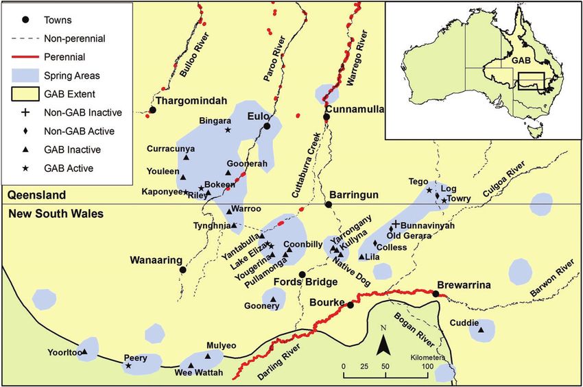
River, while Cuttaburra Creek and the Paroo River
                                                              terminate in extensive floodplains and ephemeral lakes.

                                                              Groundwater History
                                                              Indigenous History
                                                                   Throughout the study area, Aboriginal hunting, gath-
                                                              ering, and ceremonial activities were concentrated along
                                                              watercourses and pathways linking permanent water
                                                              (Humphries 2007; McKellar 1984) while dispersal was
                                                              facilitated by intermittent rainfall, shallow native wells,
                                                              and a sparse networks of springs. Archeological inves-
                                                              tigations at Youleen Springs (Robins 1995) and Cuddie
                                                              Springs (Field 2006; Trueman et al. 2005) revealed uti-
                                                              lization extending back to the Pleistocene.
                                                                   Many springs and waterholes throughout the study
                                                              area have retained their Aboriginal names, or at least
                                                              anglicized versions, although their precise meaning and
                                                              stories seem to be lost. Aboriginal people considered
                                                              springs to be the creation of powerful spirits and ancestral
                                                              beings and thus possessed potent spiritual and cultural
                                                              meaning. One Aboriginal narrative asserts that the “Yanta”
                                                              spirits saw people dying during drought and sought
                                                              to protect mankind by excavating springs across the
                                                              landscape (Langloh 1905). The spirits began at Yantabulla
                                                              springs which are purportedly named after them (Langloh
Figure 1. Great Artesian Basin, showing spring supergroups
                                                              1905), though some accounts suggest that Yantabulla
and recharge areas along elevated outcrops. The supergroups
discussed in this paper include Bogan River, Bourke, and      means “stones around a spring” (Geographical Names
Eulo.                                                         Board NSW 2013). The “Yanta” then went out to the
                                                              “Kinggle” Plain to create a permanent lake, however
                                                              gradually died of exhaustion. “Kinggle” is an obscure,
and proliferation of bores, springs provided a natural        unknown place name which does not appear on any maps.
outlet for the GAB. Clustered in so-called “supergroups”      According to Langloh (1905) Aboriginal people would no
(Habermehl 1982), GAB springs emerge along the edges          longer cross this plain for fear of disturbing their graves
of the basin, near Palaeozoic intrusions and through fault    “resting above the springs” (Langloh 1905).
lines which breach the confining layers (Rade 1954).               According to one account the Aboriginal etymology
     This study area comprises the south-eastern portion      of Cuddie Spring meant “bad water” though it was also
of the GAB including the Eulo, Bourke, and Bogan River        conceded that this word may have been applied to a
supergroups (Figures 1 and 2). Since European settlement      number of locations in the Brewarrina district (Abbott
in the mid-19th century, economic activity has focused        1881). During an archeological investigation at Cuddie
mainly on the grazing of sheep, cattle and, more recently,    Springs in the 1930s (Anderson and Fletcher 1934), an
goats. The region is semi-arid with mean rainfall ranging     Aboriginal legend was recounted which explained the
from 300 to 500 mm per annum. There are also aquifers         fossilized bones of extinct giant marsupials found in
in the Tertiary sandstone overlying the GAB, and some of      the spring (Field 2006; Trueman et al. 2005) as well as
these outcrops have perennial springs.                        perhaps the connotation of “bad water”:
     Apart from the springs, natural permanent surface
water is restricted to the south, east, and northern              Long ago there was an immense gum tree, miles
extremes of the study area. The Darling River is a perma-         in height, which grew on the bank of the Geerah
nent downstream from Brewarrina. The Warrego River                waterhole on the Barwon River, eleven miles north of
supports numerous permanent waterholes (here defined as           Cuddie Springs. Near it was an aboriginal camp, and
those which have not gone dry since pastoral settlement;          in its branches a pair of huge eagles had built their
                                                                  nest, wither they used to carry the little black babies
see Fensham et al. 2011) although the stream dissipates
                                                                  to feed their young. At last the blacks decided to get
into anabranches south of Cunnamulla. Cuttaburra Creek            rid of these troublesome neighbours by cutting down
diverts flood waters from the Warrego River and forms             the tree. When it was done the trunk was found to be
just two permanent waterholes in New South Wales                  hollow, and, in defiance of the laws of hydrostatics,
(NSW). The Paroo River contains just three permanent              the water ran along this huge pipe, emerging from the
waterholes between Eulo and Hungerford. During floods,            top end, where it fell at Cuddie Springs, the escaping
the Warrego and Culgoa may flow and join the Darling              water making a deep hollow in which were deposited

172       O. Powell et al. Groundwater 53, no. 1: 171–178                                                         NGWA.org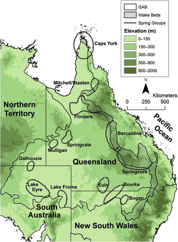
Figure 2. The study area showing the extent of the GAB, non perennial streams, surface water and spring areas and springs
mentioned in the text.

    the bones of the animals which had formed the food         country to the north (Mitchell 1839). In 1847, Edmund
    of the eaglets. So, according to the legend, did Cuddie    Kennedy traced the Warrego River south until it ran
    Springs come into being, and this is the origin of the     dry below Cunnamulla, forcing him to make a desperate
    bones found there.                                         march without water to the Culgoa River (Beale 1983).
     As places of intense economic and cultural activity,      European pastoralists followed the eastern tributaries of
it is not surprising that springs are rich sites of indige-    the Darling River and began selecting land in the 1850s,
nous material culture. Artifact scatters consisting of stone   concentrating their runs along the reaches of permanent
flakes, cores, grindstones, axes, and hearths are typically    and semi-permanent water (Heathcote 1965) (Figure 2).
associated with scalded areas and claypans adjacent to               The artesian springs provided the only perennial
springs, which partly reflects their obvious visibility in     water source between the Darling River and the enduring
these landscapes (Robins 1993). The field records of the       waterholes on the ephemeral streams in southern Queens-
authors reveal especially rich and dense surface arche-        land (Figure 2) and were important stepping stones for
ology on the groundwater scalds surrounding Coonbilly,         the pioneering squatters. Thomas Dangar was one of the
Goonery, Kullyna, Lake Eliza, Warroo, Peery Lakes, and         first who established a station on a waterhole of the War-
Native Dog Springs in New South Wales and at 30 spring         rego River to the north of Cunnamulla in 1859. Kullyna
groups in Queensland, including Bokeen, Kaponyee, Riley        Spring was a “perfect oasis in the desert” (Anon 1868)
and Youleen as documented by Robins (1993).                    and, during one dry period, a local Bourke correspondent
                                                               commented that “were it not for the springs on this route
Exploration and Early Settlement                               [Native Dog, Yarrongany, and Kullyna], all communica-
     In 1828, Charles Sturt explored the Darling River         tion with the north must stop” (Anon 1865).
along its permanent reaches during a severe drought                  While conducting explorations into Queensland’s
whereby its diminished level enabled him to observe            Paroo and Bulloo River country in 1861, Vincent Dowling
brackish seepage discharging into the river (Sturt 1982).      discovered several springs including Yantabulla where
Sturt’s record of the parched landscape and unpotable          he later established a station (Dowling 1861). In the
waters created an unfavorable impression which discour-        early 1860s, while prospecting west of the Darling River,
aged immediate settlement of the area. Thomas Mitchell         Bloxham (1885), found Goonery Springs, which would
explored the Darling River Region in 1835 and 1836,            later form a link to the lower Paroo River. In 1865, John
however, his instructions were to establish its southern       Costelloe and his family drove 200 cattle and 15 horses
outlet to the ocean and he therefore ignored the dry           through the dry country north-west of Bourke relying on

NGWA.org                                                       O. Powell et al. Groundwater 53, no. 1: 171–178       173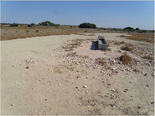
a depot at “Warroo Springs” (O’Neill 1969). This later
became a launch pad for his family’s expansion into
Queensland’s channel country and the foundation of a vast
pastoral empire (Durack 1959).
Artesian springs became sites of towns and isolated
“bush shanties,” as well as the basis for early stock routes
which later became main roads. The Bourke-Hungerford
road traces a line of springs once followed by historical
luminaries including Dowling, Costelloe, the celebrated
“bush poet” Henry Lawson, as well as countless unknown
shearers and swaggies. The Bourke-Wanaaring road leads
directly to Goonery Springs before turning north-west to
the Paroo River. The Bourke-Barringun-Cunnamulla route
leads directly to Native Dog Springs and passes within
2 km of Kullyna Spring. Queensland’s 4 mile map series
from 1913 shows the original Brewarrina-Cunnamulla
road following Towry, Log, and Tego Springs. This road
no longer exists, but old wagon tracks are still visible in
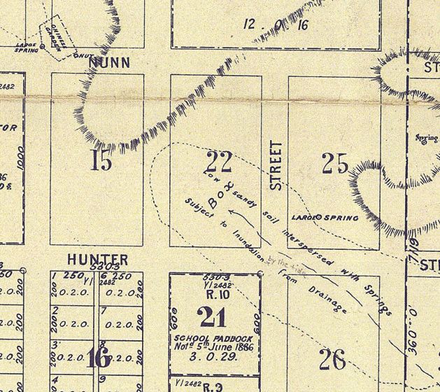
places. Figure 3. Town plan of Yantabulla depicting numerous
Vincent Dowling’s homestead at Yantabulla became springs including ‘Chinese Garden’ near a ‘large’ spring
(source: Yantabulla Town Plan, 1887, Land and Properties
a hotel and by 1887 a town plan depicted neatly gridded Information, NSW Government).
streets based around numerous springs (Figure 3). The
“Whip Spring” with a wetland of roughly 2023 m2 (Gilliat
1885) was probably the most important source of water, 1934). The water rose to the surface at the rate of
but another spring, yielding a supply estimated to be 600 11,365 L/day and was channeled to stock on firmer ground
to 700 buckets per day, watered a Chinese market garden (Abbott 1881).
(Gilliat 1885). In the early 1880s, the Youngerina Hotel, Youngerina was one of the largest springs along the
named after the local spring, was established along the Bourke-Hungerford route comprising an area of 80.5 m2
side of the Bourke-Hungerford road (Anon 1932). Lake and rising in a 0.9-m mound. After installing shafts
Eliza is thought to contain several muddy soaks supported and trenches the estimated flow was between 6819 and
by artesian water (Pickard 1992). There was a hotel at one 8183 L/day (Gilliat 1885). After discovering Goonery
point (Anon 1961) and while not mentioning the springs Springs, E.J. Bloxham excavated detritus from a hole he
this “lonely pub in mulga scrub” featured in Henry Law- found in a mound of reeds. Although it was “a splendid
son’s poem “Lake Eliza” (Lawson 1893). In search of the looking spring” supporting a lush wetland, it could only
lost explorer Ludwig Leichhardt, in 1865 Duncan McIn- fill a 200 gallon (909 L) cask in 24 h (Bloxham 1885).
tyre followed the Paroo River and camped at Curracunya Later “improvements” to Goonery and Lila Springs meant
Spring (Anon 1866) which became a mail stop and later a that both were capable of watering around 8000 sheep in
small township with an inn. An inn and small settlement any season (Kelly 1882). Evidence of European attempts
also existed at Tego Springs. A well was sunk adjacent to increase spring flow is still evident in the excavated
to the main spring (Ogilvie 1911) and this water supplied Tertiary sandstone around Old Gerara and Bunnavinya
a Cobb & Co station, post office, and numerous houses. Springs.
Financial investment in fledgling pastoral operations
in the 1860s and 1870s accelerated pastoral development Signposts to the Aquifer
(Cain and Com 1962). Artesian springs were immune to Aboriginal people had strong prescriptions for the
the ravages of drought and were critical assets within the sustainable exploitation of resources as well as profound
burgeoning enterprise of tanks, dams, wells, stockyards, reverence of watering places. Under European manage-
buildings, and roads, as well as hundreds of miles ment, focus shifted from the sacred to the utilitarian, but
of new fencing. The soupy substrates of springs were the Europeans created their own secular story with the
a death trap for stock and their supplies were often “discovery” of the artesian water source (Powell 2012).
limited. Excavations, trenches, and shafts were necessary The exploitation of artesian springs by pastoralists, in con-
to redirect and increase their flows. junction with sinking shallow wells, identified the extent
Cuddie Spring was described as a “bog hole” which of groundwater supplies as well as highlighting the influ-
never dried up “even in the greatest of droughts” (Abbott ence of local geology on both water quality and quantity.
1881), however, during one dry period in the late 1870s, Throughout the study area, shallow groundwater asso-
the area dried sufficiently to enable the local manager to ciated with unconsolidated Cainozoic stratum is often
fence the spring and sink a well. This first excavation brackish (Williams et al. 1994). The fresh, potable sources
revealed that numerous sheep, cattle, and horses had of water from the artesian springs indicated that another
suffered the same fate as the Australian mega-fauna more substantial source of groundwater might exist at
that preceded them (Abbott 1881; Anderson and Fletcher greater depth.
174 O. Powell et al. Groundwater 53, no. 1: 171–178 NGWA.org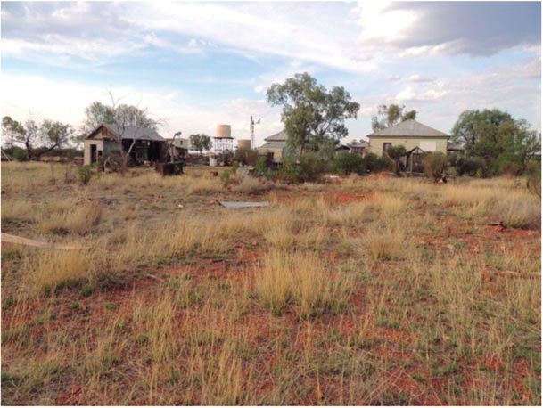
At Yantabulla, shallow wells encountered salty water          “same position geologically, the water coming from below
until a deeper well sunk to 12.2 m on the site of a                the Cretaceous marl and shale deposit which occupies so
dormant spring “bottomed out in a sandy drift,” with fresh         large a portion of the country” (Brown 1885). Wilkinson
water rising 3 m from the surface yielding approximately           (1885) recognized that the Cretaceous formation was of
682 L/day (Gilliat 1885). At Warroo Springs the manager            “great importance” and made the prescient suggestion
sank a 6-m shaft and encountered brackish water, but               that deep bores could supply the entire district in the
struck a good supply at 18 m depth (Gilliat 1885).                 future. The Bourke district surveyor, Edward MacFarlane,
Tynghynia Springs was described as yielding an excellent           noted that the springs of north-west NSW ran a general
supply sufficient for a boundary rider’s hut though a              line south-west to north east, which roughly describes
nearby well yielded salt water from a “white drift and             the general layout of the Bourke Supergroup (Figures 1
water worn boulders” (Gilliat 1885).                               and 2). Indicating the extent of the GAB, he reported that
     With the introduction of shallow boring plants in             similar artesian flows south of the Darling River were
the region (see Wood 1883), springs signposted access              unknown (MacFarlane 1885).
points to the artesian aquifer. The first deep bore came
about through a private drilling operation at Wee Wattah           Discovering the GAB
Springs (Figure 4) on Killara station south-west of Bourke              Early artesian wells and bores were only modest
in 1878 (Wilkinson 1882; Percy 1906). At a depth of                improvements on springs, due to the lack of experienced
43 m, the bore initially yielded 326,880 L/day until the           bore contractors and technological limitations, as well as
shaft became choked with sand and flows diminished. At             the prohibitive costs of deep drilling beyond the upper
Mulyeo Spring, also on the Killara holding, four bores             Cretaceous layers (Powell 2012). Powerful machines had
were put down though three were later abandoned due to             been developed in North America (Darley 1884), but
their low supply (Wilkinson 1882). On Dunlop station, a            conservative public servants were skeptical of the value
government bore contractor described his intention to sink         and highlighted the risks of introducing cumbersome
a shaft at Goonery Springs along the Bourke-Wanaaring              and expensive plants to the remote districts (Henderson
Track in which he felt “not the slightest doubt that we will       1885). Severe drought and ambitious private investment,
get the artesian water at 100 feet [30.5 m]” (Anon 1883).          however, eventually provided the catalyst for discovering
     During the NSW Royal Commission of Water,                     “secure” artesian supplies. This was a high risk enterprise
considerable evidence was collected on springs and                 because bore drilling operations had not ventured from the
bores, contributing to a fledgling understanding of the            immediate vicinity of the springs where reliable supplies
artesian system in north-west NSW. The Superintendent              at relatively shallow depths seemed almost guaranteed.
of Diamond Drills, reported that the artesian water from                In 1886, the year after the Queensland Government’s
the bore at Goonery Springs came from three different              failed attempt to establish a deep test bore in central
levels, the last being from a “blue gray flinty-sandstone”         Queensland, a private contractor on the Thurulgoona
(Henderson 1885). The formation of the springs was                 property, north-west of Barringun, used a large North
associated with a shallow granite basement at 58.5 m               American style rig and struck a supply of 363,680 L/day
which forced water “through the weak points in the clay”           at just over 305 m (Powell 2012). The success on
(Ford 1885). The government geologist, H.L. Brown,                 Thurulgoona was quickly mirrored across the NSW
argued that all of the mud springs in the district were in the     border as the managers of the Kerribree Station sank
                                                                   the first “deep,” artesian bore in NSW at a depth of
                                                                   310 m yielding a supply of 1,636,592 L/day (Anon 1888).
                                                                   The Kerribree No. 2 bore watered a fruit orchard and a
                                                                   paddock of cereals while the fourth bore yielded a supply
                                                                   of 7,273,774 L/day (Anon 1892).
                                                                        The deep bore logs (Figure 5) generated a better
                                                                   understanding of the GAB as well as its potential for
                                                                   broad scale exploitation (David 1893; Symmonds 1912;
                                                                   Cox 1902). It was reasoned that Palaeozoic rocks probably
                                                                   formed a barrier to the southern outlet of the GAB in
                                                                   NSW and that the springs often occur along the junction
                                                                   of the Cretaceous strata and bedrock which “formed the
                                                                   margin of the Cretaceous ocean” (David 1891). A similar
                                                                   observation associating springs with the edge of the Basin
                                                                   (e.g., Wee Wattah, Mulyeo, and Peery Lakes) was made
                                                                   during the First Interstate Conference on Artesian water in
                                                                   1912 (Pittman et al. 1913). Because the springs occurred
Figure 4. A low mound and carbonate scald 70m south-               at the margins of the basin or near granite intrusions,
east of Wee Wattah bore possibly represents the site of the        bores drilled in their vicinity were generally found to
original spring. The raised area on the left horizon is the site
of the bore.
                                                                   yield modest supplies (Pittman and David 1903). The
                                                                   fossils from deep bores located further from the basin’s

NGWA.org                                                           O. Powell et al. Groundwater 53, no. 1: 171–178        175
Figure 5. Drilling rig located along the Bourke-Hungerford Figure 6. Diminution of artesian supply from select bores
road c.1895. This road once followed a line of springs which in the Warrego River and Paroo River region (source:
are now mostly inactive (source: State Library of NSW, item Queensland Artesian Water Investigation Committee 1955).
03632).
edge subsequently revealed artesian water to be derived
from sedimentary layers other than the Cretaceous leading
to speculation that the “porous strata of the Trias-Jura
formation may constitute the chief storage beds of the
artesian water supply of Australia” (Pittman 1895).
Oases to Oblivion
Through mostly private investment, artesian bores
proliferated (Powell 2012) and water was diverted into
miles of excavated bore drains which opened up vast
stretches of new grazing country. Much of the water
was wasted through seepage and evaporation. By the turn
of the 20th century, surface pressures across the south-
eastern portion of the GAB declined significantly (Pittman Figure 7. Abandoned houses in the old township of Yantab-
et al. 1913). Overshadowed by diminishing supply from ulla, once the site of numerous active springs.
bores and, in some cases, complete bore failure (Figure 6)
records for the extinction of springs are scant. Wee Wattah
Spring included a wetland of 12.2 m diameter (Wilkinson Pullamonga springs. The vestiges of a tumbled down hut
1882), and ceased immediately after the nearby bore lie beside the Tertiary Colless Spring. The stone ruins of
was established (Pittman and David 1903) while Cuddie Youldoo homestead and abandoned well sit on a barren
Springs suffered a similar fate when a local bore was rise above the inactive Yourltoo Spring, while abandoned
put down at the turn of the 20th century (Anderson and outstations mark the sites of Goonerah, Old Bingara, and
Fletcher 1934). As the bores diminished aquifer pressure, Bokeen springs in Queensland. The old shanties and road
springs flows declined or ceased throughout the district side settlements similarly faded from history as the springs
(Figure 2). A recent survey by the authors revealed that dried up and new forms of mechanized transport reduced
around 55% of spring groups across the Eulo, Bourke, and the need for stop overs when traveling across the vast
Bogan River supergroups have been rendered inactive due distances of dry country.
to groundwater extraction, while many of the remaining Under the Great Artesian Sustainability Initiative
springs have diminished in flow. Just 13 spring groups in (GABSI) and other related bore-capping programs, con-
NSW and 47 in Queensland remain active (see Table S1). siderable progress has been made in restoring aquifer
The extinction and declining relevance of springs pressure. By mid-2008, more than 1000 bores had been
is graphically illustrated by their abandonment and controlled across the GAB and close to 17,700 km of
gradual disappearance from the modern cartographic earthen drains have been replaced with pipe, resulting
record. Deserted houses (Figure 7), as well as extensive in estimated water savings of around 284 GL per year
scatterings of Aboriginal and European cultural artifacts (GABCC 2009).
indicate that Yantabulla was once nourished by numerous Previously “subartesian” bores have begun flowing
springs but they are not indicated on current maps. The again in south-west Queensland (see Powell 2011).
remains of old woolsheds can be found at Old Gerara and However, much work remains to be done to close the
176 O. Powell et al. Groundwater 53, no. 1: 171–178 NGWA.orgremaining network of open bores. As this important Bentley, H.W., F.M. Phillips, S.N. Davis, M.A. Habermehl, P.L.
project progresses it is plausible that springs may also be Airey, G.E. Calf, D. Elmore, H.E. Gove, and T. Torgersen.
1986. Chlorine 36 dating of very old groundwater: 1. The
reactivated, but there is no evidence of springs returning
Great Artesian Basin, Australia. Water Resources Research
from “oblivion to oases” yet. The rapid demise of the 22, no. 13: 1991–2001.
springs across the south-eastern GAB is a powerful illus- Blake, T., and M. Cook. 2006. Great Artesian Basin Historical
tration of the dramatic transformations that have occurred Overview . Brisbane, Australia: Queensland Government
within dry land environments over the last century. Natural resources, Mines and Water.
Bloxham, E.J. 1885. Royal Commission of Water: Evidence of
Mr. E.J. Bloxham. Votes and Proceedings of the Legislative
Council 6: 762–767.
Acknowledgments Brown, H.Y.L. 1885. Royal Commission on Water: Evidence of
The authors would like to acknowledge Bruce Gray Mr H.Y.L. Brown. Votes and Proceedings of the Legistlative
for his administration and encouragement as well as Council 6: 413.
Brune, G. 1981. Springs of Texas. Austin: Texas A&M
John Pickard for his pioneering work in NSW. The University Press.
authors would also like to acknowledge NSW Land and Cain, N., and B. Com. 1962. Companies and squatting in
Property Information for their assistance and provision the Western Division of New South Wales. In The
of historical maps. Simple Fleece Studies in the Australian Wool Industry, ed.
A. Barnard, 435–456. Melbourne, Australia: Melbourne
University Press.
Collon, P., W. Kutschera, H.H. Loosli, B.E. Lehmann, R.
Supporting Information Purtschert, A. Love, L. Sampson, D. Anthony, D. Cole,
Additional Supporting Information may be found in the B. Davids, D.J. Morrissey, B.M. Sherrill, M. Steiner, R.C.
online version of this article: Pardo, and M. Paul. 2000. 81Kr in the Great Artesian Basin,
Australia: A new method for dating very old groundwater.
Table S1. Activity and spring attributes in the Bogan, Earth and Planetary Science Letters 182, no. 1: 103–113.
Bourke, and Eulo Supergroups. Cox, W.G. 1902. The Artesian water-supply of Australia from a
geographical standpoint. The Geographical Journal 19 no.
5: 560–571.
References Darley, C.W. 1884. Notes on Drilling and Boring Artesian Wells:
As Practiced in the United States of America. Sydney,
Abbott, W.E. 1881. Notes of a journey on the Darling. Journal Australia: Thomas Richards, Government Printer.
and Proceedings of the Royal Society of NSW 15: 41–70. David, T.W. 1893. Notes on Artesian water in New South Wales
Aldumairy, A. 2005. Siwa: Past and Present. Alexandria, Egypt: and Queensland. Journal and Proceedings of the Royal
Yasso. Society of NSW 27: 408–443.
Anderson, C., and H.O. Fletcher. 1934. [title illegible] Nambour David, T.W. 1891. Artesian water in New South Wales. Journal
Chronicle and North Coast Advertiser, February 16, 1934, and Proceedings of the Royal Society of NSW 25: 286–296.
2. http://trove.nla.gov.au/ndp/del/page/7640898?zoomLevel Davis, S.N., and A.G. Davis. 1997. Saratoga Springs and early
=1 (accessed November 20, 2013). hydrogeochemistry in the United States. Ground Water 35,
Anon. 1932. The old pioneering days: In the years when no. 2: 347–356.
Bourke was young. The Land , September 30, 1932, 24. Dowling, V. 1861. Vincent J. Dowling papers, 1859–1861;
http://trove.nla.gov.au/ndp/del/page/11237115?zoomLevel Exploration and rough survey of the Paroo River in 1861.
=1 (accessed November 20, 2013). Manuscript 1643, Mitchell Library, Sydney.
Anon. 1883. Water prospecting by boring. Australian Town and Durack, M. 1959. Kings in Grass Castles. Sydney, Australia:
County Journal . http://trove.nla.gov.au/ndp/del/page/50549 Thomas C. Lothian Pty Ltd.
83?zoomLevel=1 (accessed November 20, 2013). Fairfax, R., and R. Fensham. 2002. In the footsteps of J. Alfred
Anon. 1892. Bourke. Australian Town and Country Journal , Griffiths: A cataclysmic history of Great Artesian Basin
29 October, 1892, 13. http://trove.nla.gov.au/ndp/del/page/ springs in Queensland. Australian Geographical Studies 40,
5236865?zoomLevel=1 (accessed November 20, 2013). no. 2: 210–230.
Anon. 1888. Water struck on Kerribree Run. Sydney Morning Fensham, R.J., J.L. Silcock, A. Kerezsy, and W. Ponder. 2011.
Herald , November 24, 1888, 15. http://trove.nla.gov.au/ Four desert waters: Setting arid zone wetland conservation
ndp/del/page/1388274?zoomLevel=1 (accessed November priorities through understanding patterns of endemism.
20, 2013). Biological Conservation 144: 2459–2467.
Anon. 1868. The Upper Darling and the Warrego. The Queens- Fensham, R.J., and R.J. Fairfax. 2003. Spring wetlands of
lander, 10 April, 1868, 8. http://trove.nla.gov.au/ndp/del/ the Great Artesian Basin, Queensland, Australia. Wetlands
page/2049229?zoomLevel=1 (accessed November 20, Ecology and Management 11, no. 5: 343–362.
2013). Field, J.H. 2006. Trampling through the Pleictocene: Does
Anon. 1866. The Leichhardt Expedition [from the Riverine taphonomy matter at Cuddie Springs. Australian Archae-
Herald], April 6, 1866, 3. The Sydney Morning Herald . ology 63: 9–20.
http://trove.nla.gov.au/ndp/del/page/1472014?zoomLevel=1 Ford, H.W. 1885. Royal Commission of Water: Evidence of Mr.
(accessed November 20, 2013). H.W Ford. Votes and Proceedings of the Legislative Council
Anon. 1865. Bourke. The Maitland Mercury and Hunter River 6: 771–774.
General Advertiser, March 28, 1865, 3. http://trove.nla.gov. GABCC. 2009. Great Artesian Basin Strategic Management
au/ndp/del/page/140027?zoomLevel=1 (accessed Novem- Plan: Progress and Achievements to 2008 . Canberra,
ber 20, 2013). Australia: GABCC.
Anon. 1961. All those Hotels. Western Herald , May 12, 1961, Geographical Names Board of NSW. 2013. http://www.gnb.
11. http://trove.nla.gov.au/ndp/del/page/10637501?zoomLe nsw.gov.au/
vel=1 (accessed November 20, 2013). Gilliat, H.A. 1885. Royal Commission of Water: Notes on the
Beale, E. 1983. Kennedy the Barcoo and Beyond 1847 . Hobart, mud springs and some shafts and borings of underground
Australia: Blubber Head press. supply on the road between Ford’s Bridge (on the Warrego
NGWA.org O. Powell et al. Groundwater 53, no. 1: 171–178 177River) and Hungerford (on the Paroo River). Votes and Pittman, E.F. 1895. On the occurrence of artesian water in rocks
Proceedings of the Legislative Council 6: 827–828. other than the cretaceous. Journal and Proceedings of the
Habermehl, M.A. 1982. Springs in the Great Artesian Basin, Royal Society of NSW 29: 408–415.
Australia: Their Origin and Nature. Canberra, Australia: Pittman, E.F., J.B. Henderson, A.G. Maitland, A.S. Keyon, L.K.
Bureau of Mineral Resources, Geology and Geophysics. Ward, H.H. Dare, R.F. Jenkins, and J.E. Slade. 1913. Report
Harris, C.R. 1981. Oases in the desert: The mound springs of of the Interstate Conference on Artesian Water. Sydney,
northern South Australia. Royal Geographical Society of Australia: William Applegate Gullick, Government Printer.
Australia, South Australia Branch 81: 26–39. Pittman, E.F., and T.W. David. 1903. Irrigation geologically
Heathcote, R.L. 1965. Back of Bourke: A Study of Land Appraisal considered with special reference to the artesian area of
and Settlement in Semi-arid Australia. London, England; New South Wales. Journal and Proceedings of the Royal
New York: Melbourne University press. Society of NSW 37: CIII–CLIII.
Henderson, W.B. 1885. Royal Commission of Water: Evidence Ponder, W.F. 1986. Mound springs of the Great Artesian
of Mr W.B. Henderson. Votes and Proceedings of the Basin. In Limnology in Australia, Vol. 61, ed. P. Deck-
Legislative Council 6: 631–634. ker and W.D. Williams, 403–420. Houten, Netherlands:
Herczeg, A.L., T. Torgersen, A.R. Chivas, and M.A. Habermehl. Springer. http://link.springer.com/chapter/10.1007%2F978-
1991. Geochemistry of ground waters from the Great 94-009-4820-4_25
Artesian Basin, Australia. Journal of Hydrology 126, no. Powell, O. 2012. Song of the artesian water: Aridity, drought
3–4: 225–245. and disputation along Queensland’s pastoral frontier in
Humphries, P. 2007. Historical indigenous use of aquatic Australia. The Rangeland Journal 34: 305–317.
resources in Australia’s Murray-Darling Basin, and its Powell, O. 2011. Warrego Country: Water, people, landscape.
implications for river management. Ecological Management PhD thesis, University of Queensland, Australia.
& Restoration 8, no. 2: 106–113. Powell, J.M. 1991. Plains of Promise Rivers of Destiny.
Idris, H. 1996. Springs in Egypt. Environmental Geology 27, no. Brisbane, Australia: Boolarong Publications.
2: 99–104. Queensland Artesian Water Investigation Committee. 1955.
Jiao, J.J. 2010. Crescent Moon Spring: A disappearing natural Artesian Water Supplies in Queensland . Brisbane, Aus-
wonder in the Gobi Desert, China. Ground Water 48, no. tralia: Government Printer.
1: 159–163. Rade, J. 1954. Geology and sub-surface waters of the area north
Keleher, M.J., and R. Rader. 2008. Bioassessment of artesian of the Darling River between longitudes 145◦ and 149◦ E.
springs in the Bonneville Basin, Utah, USA. Wetlands 28, Journal and Proceedings of the Royal Society of NSW 88,
no. 4: 1048–1059. no. 24–32.
Kelly, J.E. 1882. Well Sinking, water storing and irriga- Roberts, C.R., and C.W. Mitchell. 1987. Spring Mounds
tion in the interior. Sydney Morning Herald . http://trove. in southern Tunisia. Geological Society London, Special
nla.gov.au/ndp/del/page/1419174?zoomLevel=1 (accessed Publications 35: 321–334.
November 20, 2013). Robins, R. 1995. Archaeological investigations at Youlain
Langloh, K. 1905. The Euahlayi Tribe: A Study of Aboriginal Springs, Southwest Queensland. Memoirs of the Queens-
Life in Australia. London, England: Constable. land Museum 1, no. 1: 57–74.
Lawson, H. 1893. Lake Eliza. The Bulletin 13, no. 722: 20. Robins, R. 1993. Archaeology and the Currawinya Lakes:
Lehmann, B.E., A. Love, R. Purtschert, P. Collon, H.H. Loosli, Towards a prehistory of arid lands of southwest Queens-
W. Kutschera, U. Beyerle, W. Aeschbach-Hertig, R. Kipfer, land. PhD thesis, Griffith University, Australia.
S.K. Frape, A. Herczeg, J. Moran, I.N. Tolstikhin, and M. Sturt, C. 1982. Two Expeditions into the Interior of Southern
Gröning. 2003. A comparison of groundwater dating with Australia, during the Years 1828, 1829, 1830, and 1831:
81Kr, 36Cl and 4He in four wells of the Great Artesian With Observations on the Soil, Climate, and general
Basin, Australia. Earth and Planetary Science Letters 211, Resources of the Colony of New South Wales. Sydney,
no. 3–4: 237–250. Australia: Doubleday Australia.
MacFarlane, E. 1885. Royal Commission of Water: Evidence Symmonds, R.S. 1912. Our Artesian Waters: Observations in the
of Mr. Edward MacFarlane. Votes and Proceedings of the Laboratory and in the Field . Sydney, Australia: William
Legislative Council 6: 669–771. Applegate Gullick, Government Printer.
McKellar, H. 1984. Matya-Mundu. Cunnamulla, Australia: Torgersen, T., M.A. Habermehl, F.M. Phillips, D. Elmore, P.
Cunnamulla Australian Native Welfare Association. Kubik, G.B. Jones, T. Hemmick, and H.E. Gove. 1991.
Mitchell, T. 1839. Three Expeditions into the Interior of Eastern Chlorine 36 Dating of very old groundwater: 3. Further
Australia: with Descriptions of the Recently Explored studies in the Great Artesian Basin, Australia. Water
Regions of Australia Felix, and of the Present Colony of New Resources Research 27, no. 12: 3201–3213.
South Wales, 2nd ed. London, England: T. & W. Boone. Trueman, N.G., J.H. Field, J. Dortch, B. Charles, and S. Wroe.
2005. Prolonged coexistence of humans and megafauna in
Ogilvie, C. 1911. Artesian Bore Reports of Inspector: C. Ogilvie.
Pleistocene Australia. PNAS 102, no. 23: 8381–8385.
Queensland State Archives Item ID291259, Reports-
Wilkinson, C.S. 1885. Royal Commission of Water: Evidence
Inspection.
of Mr. Edward MacFarlane. Votes and Proceedings of the
O’Neill, S. 1969. Costello, John (1838–1923). In Australian
Legislative Council 6: 588–596.
Dictionary of Biography. Canberra, Australia: National
Wilkinson, C.S. 1882. Notes on the occurrence of artesian wells
Centre of Biography, Australian National University.
in the Albert District, New South Wales. Proceedings of the
Park, W.-B., and K. Ha. 2012. Spring water and water culture
Linnean Society of NSW 6: 155–157.
on Jeju Island. Ground Water 50, no. 1: 159–165.
Williams, R.M., D.R. Wooley, R.S. Abell, P. Please, and W.R.
Patten, D., L. Rouse, and J. Stromberg. 2008. Isolated spring
Evans. 1994. Darling basin hydrogeological map land and
wetlands in the Great Basin and Mojave Deserts, USA:
water management issues. In Water Down Under 94 , Vol.
Potential response of vegetation to groundwater withdrawal.
1. Adelaide, Australia: Institution of Engineers.
Environmental Management 41, no. 3: 398–413.
Wood, A.P. 1883. Tanks and wells of New South Wales, water
Percy, A. 1906. The Drought Antidote for the North-West: Or, the supply and irrigation. Journal and Proceedings of the Royal
Utilisation of the Artesian Resources of New South Wales. Society of NSW 17: 149–186.
Sydney, Australia: Government Printer.
Pickard, J. 1992. Artesian Springs in the Western Division of New
South Wales. Sydney, Australia: Maquarie University.
178 O. Powell et al. Groundwater 53, no. 1: 171–178 NGWA.orgYou can also read