Fish passage system in an irrigation dam (Pilcomayo River basin): When engineering designs do not match ecohydraulic criteria
←
→
Page content transcription
If your browser does not render page correctly, please read the page content below
Neotropical Ichthyology, 10(4):741-750, 2012
Copyright © 2012 Sociedade Brasileira de Ictiologia

          Fish passage system in an irrigation dam (Pilcomayo River basin):
            When engineering designs do not match ecohydraulic criteria

        Claudio R. M. Baigún1, John M. Nestler2, Priscilla Minotti3 and Norberto Oldani4

The Route 28 Dam has the potential to block fish movements from La Estrella marsh to the Pilcomayo River. In addition, the
many fish that concentrate immediately downstream of the dam may suffer high mortality when they are stranded during
low water periods. The goals of this study are to determine if fish are able to pass the spillway and to assess if the design
of the installed ladders (pool and weir type) effectively supports upstream migration of Prochilodus lineatus (sábalo).
Results showed that only fish longer than 39 cm should be able to ascend the spillway chute, but when water levels on the
spillway crest are over 0.4 m. Fish are also unable to jump from spillway toe to spillway crest because the downstream
dissipation pool does not meet the minimum depth criterion for fish to accelerate to sufficient velocity. Fish ladders have
insufficient number of pools and some pool dimensions and designs depart from accepted standard designs. Volumetric
dissipation power in the upper pool of each fish ladder is too low for fish to rest. Also, attraction flows relative to total
spillway discharge at the entrance to each fishway are insufficient. Fish passage failures of both the spillway and pool and
weir systems in La Estrella marsh can be traced to the “salmon-centric” concept used by the designers. We conclude that
the Route 28 Dam design including its fish passage systems, do not follow criteria to cope with the strong hydrological
variability and bioecological characteristics of fish inhabiting pulsatile systems such as La Estrella marsh.

La represa de la ruta 28 posee el potencial de bloquear el desplazamiento del sábalo (Prochilodus lineatus) desde el bañado
La Estrella hacia el río Pilcomayo. Adicionalmente los numerosos peces que se concentran aguas abajo de la represa pueden
sufrir una alta mortalidad cuando quedan atrapados durante el período de aguas bajas. Los objetivos de este estudio son
determinar si los peces son capaces de superar el vertedero y evaluar si el diseño de los pasos para peces del tipo tanque-
escalón ya instalados es adecuado para facilitar la migración hacia aguas arriba. Los resultados muestran que solo aquellos
peces mayores a 39 cm de longitud total son capaces de ascender la pendiente del vertedero, pero únicamente cuando el nivel
del agua en la cresta alcanza o supera los 40 cm. Los peces son incapaces de saltar desde el pie del vertedero hasta la cresta
debido a que la pileta de disipación no sigue los criterios de mínima profundidad requeridos para alcanzar la suficiente
velocidad y altura. Asimismo, los pasos para peces no poseen el número suficiente de tanques y algunas de sus dimensiones
y su diseño se apartan de los estándares aceptados. La potencia de disipación volumétrica en el tanque superior de cada paso
es inadecuada para que los peces puedan descansar, mientras que los flujos de atracción relativos a la descarga del vertedero
resultan insuficientes. La baja eficiencia del vertedero y de los sistemas de pasos para peces pueden ser adjudicados a un
concepto de construcción orientado a salmónidos. Concluimos que la represa de la ruta 28, incluyendo sus sistemas de pasaje
para peces, no siguen los criterios adecuados para hacer frente a alta variabilidad hidrológica y las características bioecológica
de los peces que habitan en bañados pulsátiles como La Estrella.

Key words: Dam spillway, La Estrella marsh, Pilcomayo basin, Pool and weir system.

                           Introduction                               (Marmulla, 2001) because they fragment the landscape
                                                                      (Agostinho et al., 2003, Fernández et al., 2007), modify flood
   Many dams augment water supply in South America                    pulses (Oldani et al., 2004, 2007) and block migratory
wherever topography and river flow are suitable. Dam                  movements (Larinier, 2001; Baigún et al., 2011). Unfortunately,
environmental impacts are increasingly an important issue             most dams still lack fish passage systems (Quirós, 1989;

1
  Instituto Tecnológico de Chascomús, (IIB-INTECH), Camino de Circunvalación Laguna, Km 6, 7120 Chascomús, Argentina.
cbaigun@gmail.com
2
  IIHR - Hydroscience & Engineering, University of Iowa, 100 Stanley Hydraulics Laboratory, Iowa City, IA 52242-1585 USA.
John.M.Nestler@gmail.com
3
  Universidad Nacional de San Martín, Peatonal Belgrano 3563, piso 1, (1650) Gral. San Martín, Argentina. priscilla.minotti@gmail.com
4
  Instituto de Desarrollo Tecnológico para la Industria Química (INTEC-CONICET-UNL), Güemes 3450, S3000 Santa Fe, Argentina.
gbio@ceride.gov.ar.

                                                                741
742 Fish passage system in an irrigation dam
Agostinho et al., 2002) except at hydroelectric dams. Even parts of the province and to provide water for land irrigation.
these systems have either ignored or underestimated the need Water regulation structures involve a main free over fall type
to adapt designs to meet the behavioral characteristics and spillway and two gated outlets functioning as secondary
swimming requirements of neotropical fish faunas (Agostinho controlled spillways. One of this controlled spillway is located
et al., 2007a; Oldani et al., 2007). The most common fish close to the main spillway and the other 6 km to the south on
passage systems installed in South America are of the pool the Salado River channel. The main spillway is 800 m long
and weir types (ladders) originally developed to pass and features three fish passage systems of the pool and weir
salmonids and clupeids in northern hemisphere rivers (Clay, type, located at the middle and at each end of the spillway.
1995; Larinier, 2001). Godoy (1985) mentioned that more than Like other marshes located on the Chaco plain, La Estrella
20 pool and weir systems in northern Brazilian dams were is a highly seasonal environment with substantial differences
constructed to pass different species such as Prochilodus between dry and wet seasons. Water level within the marsh is
scrofa, Leporinus copelandii, L. octofasciatus, L. elongatus, directed tied to the discharge of the inflowing Pilcomayo River
Salminus brasiliensis, S. hillari and Pimelodus clarias. (Guinzburg et al., 2005). The hydrological cycle is characterized
According to Agostinho et al. (2007b) such systems are by heavy rain falls in the upper basin (Bolivia) from November
suitable for low head dams less than 16 m and Baigún et al. to April and by local precipitation that peaks from October to
(2011) noted that they are mostly avoided by large migratory March. From middle the summer to fall La Estrella marsh is
bottom species. totally inundated by flows from the Pilcomayo River forming
In Argentina only two examples of pool and weir systems a large wetland that expands laterally as water runs from west
are known. The first is the Carcaraña Dam (Santa Fe Province) to east across the marsh. After the route was elevated forming
which historically passed Prochilodus lineatus (sábalo) and the dam, the marsh upstream of the dam became permanently
Salminus brasiliensis (Bonetto et al., 1971). The second is flooded even during the dry season.
the Route 28 Dam so called because the roadway runs across The study area was visited in March and April 2008,
a low-head dam and spillway crossing the marsh from north September 2009, and March 2010 to describe fish movements
to south. The construction of the Route 28 Dam created in the vicinity of the primary and secondary spillway areas
considerable controversy because it was thought that the and at fish ladders under different hydrological conditions.
dam could block sábalo migration between La Estrella marsh At each visit, when hydrological conditions allowed, visual
and the Pilcomayo River. There was concern that the blockage counts of fish attempting to ascend the spillways or pass
would prevent fish from completing their spawning through the pool and weir systems were recorded. Twenty
movements and result in high mortality as fish became local artisanal fishermen who permanently live and fish around
stranded downstream during low water periods impacting the marsh were interviewed to obtain information about fish
negatively on the important sábalo fisheries in the upper movements in the main spillway area. Total length
Pilcomayo basin (Motchek et al., 1995). distributions were obtained from fish collected at the tailwater
Surprisingly, the performance of the fish passage system at using gillnets. Water temperature, dissolved oxygen
the Route 28 Dam has never been assessed so that its adequacy concentration, conductivity, and pH were recorded with a
to mitigate the impacts of the dam is unknown. The lack of Lutron IK 2001on digital probe.
assessment is important because this fish passage system is
one of many low head dams that either have been recently
constructed or are planned for agricultural regions of Argentina
and neighboring countries. Information obtained by assessing
the overall performance of the fish passage system and by relating
the effects of specific design elements are important to ensure
environmentally sustainable water resources development
through effective mitigation and wise natural resource
management. Thus, the goals of this study are to determine for
the first time if fish are able to pass the spillway of the Route 28
Dam and to assess if the design of the pool and weir fishways
effectively supports upstream migration of sábalo.
Material and Methods
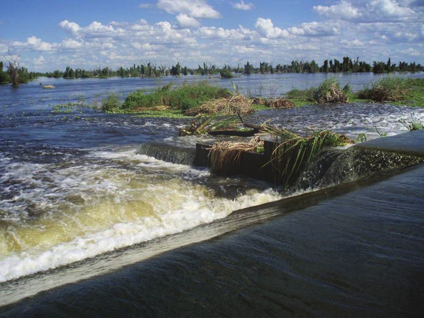
The Route 28 Dam is located in Formosa Province
(Argentina) on the east side of La Estrella marsh in the
Pilcomayo River basin (Fig. 1). The elevation of the Route 28
Dam was progressively increased from 1993 to 2003 to assure
an all-season crossing for Route 28 over the La Estrella marsh Fig.1. Location of La Estrella marsh- Route 28 Dam complex
thereby permanently connecting the northern and southern in Formosa Province, Argentina.C. R. M. Baigún, J. M. Nestler, P. Minotti & N. Oldani 743
Long term specific hydrologic data for the Route 28 Q = Cd b (2g)0.5 H11.5 (5)
Dam describing water surface elevations are unavailable. where:
Based on our periodic observations, La Estrella marsh Q = flow discharge (m3/s),
floods between February to June with the duration of Cd = discharge coefficient (0.4)
flooding dependent on regional climate patterns. We felt b =width of the notch in m, and
that measurements made during this critical period would H1 = depth of the notch in m.
provide the greatest information relating hydrologic and Flow into the upper pool of the fishway is estimated using
hydraulic conditions to fishways performance. For safety equation (5), but parameterized using information from
reasons and ease of access, morphometric measurements spillway characteristics.
of the fish ladders and main spillway were made during
the spring low water period. These measurements are used b) Volumetric dissipated power (Pv) at each pool in watts/m3
to describe important design parameters that could then is estimated (Larinier, 2002c) as:
be compared to accepted guidelines. The following Pv =g Qh (6)
formulas were employed to develop design parameters V
for an ogee crest uncontrolled flow spillway and pool where:
and weir fishway. = density of water (1000 kg/m3),
h = head differences between pools (m), and
Spillway characteristics V = volume of water in the pool (m3)
a) Discharge (Q) over the spillway in m3s-1 for a rectangular c) Optimum length of pools (L) is estimated as 12 times h
spillway with wide crest was calculated using the common (12*h) (Larinier, 2002c) with h defined as the distance from
Francis formula: the bottom of the pool to the top of the notch.
Q = CLH3/2 (1)
where: d) The number of pools (N) required for the spillway height is
L = Length of the spillway in m, determined (Larinier, 2002c) as:
C = Spillway coefficient considered as 2 and N = htot-1 (7)
H = Water height on the spillway crest (roadbed) in m h
where:
b) Water velocity (V) at spillway crest as: htot = total height computed as the difference between
V = Q/L*H (2) the spillway crest and tailwater
c) Mean water velocity (Vp) in the spillway chute in m s-1 was e) Maximum flow velocity created by the lower pool into the
estimated according to Reiser et al. (2006): tailrace is estimated (Larinier, 2002c) as:
Vp = {V2+2g [Ls sin(Sp)-dp]}3/2-V3 (3) V = (2g H)0.5 (8)
3g[Ls sin(Sp)-dp] where:
where: H = head difference between lower pool and tailrace
Ls = total chute length in meters,
Sp = chute angle = 25°, Fish swimming capabilities
g = acceleration due to gravity (9.8 m/s2), and Burst speed and endurance time are estimated for fish
dp = water depth at the tailrace in m. ranging from 25- to 45-cm in total length using the nomograms
developed by Beach (1984) assuming a water temperature of
d) Water level (Ws) in the chute in m as 25°C. Burst swimming speed represents the highest speed
Ws = H/Vp (4) that can be maintained for short periods using anaerobic
metabolism (Beamish, 1978).
Fishway characteristics
Each fishway is comprised of three rectangular pools. The a) Maximum distance that fish could swim on the spillway
upper pool is an extension of the spillway crest so that water chute against different water velocities (D) is calculated by
can overflow directly into this pool. Total discharge from upper the biocinetic equation of Katopodis (1992) as:
pool is greater than discharge of the middle and lower pool. D = (Vf-Uw) t (9)
Consequently, a different equation is needed to estimate flow where:
into the middle and lower pools versus the upper pool. Vf = fish maximum speed
Important hydraulic characteristics of the fishways are Uw = water velocity
calculated as follows. t = travel time at maximum speed
a) Flow discharge (Q) in the middle and lower pools of the b) The capacity of fish to leap from one pool to another is
ladders in m3/s is estimated (Larinier, 2002c) as: determined from the trajectory equations of Larinier (2002d)744 Fish passage system in an irrigation dam
both for maximum horizontal distance (Xmax) and maximum from 26- to 45-cm with a mode of 32-cm corresponding to a
height (Ymax) as: body depth of 10-cm (Fig. 2).
Xmax = Vo2 cossin (10)
g Structural and hydrological characteristics
Ymax = (Vosin (11) At the primary spillway water is discharged over an
2g uncontrolled 0.8-km long main spillway having a 6.7-m wide crest
where: and 1.6-m height that is typically active only during the summer
= initial leaping angle measured from the horizontal and flooding period (Fig. 3a). The spillway chute has 25° slope and
Vo = speed of the fish as it exits the water (assumed to 3.7-m length and terminates at a 0.3-m long flat apron. The apron
equal maximum burst velocity). ends at a 0.5-m deep and 4.0-m wide stilling basin. Measured
water velocities on the spillway crest ranged from 0.63 to 1.41 m/
Results s being flow supercritical, and measured water levels on the
chute vary from 0.05 to 0.15 m. Hydraulic characteristics varied
Fish movement patterns and demographic characteristics among pools in the three fishways because of small differences
Interview results from artisanal fishermen that regularly in notch height, volume, and bottom profile (Fig. 3b, c), departing
fish in the Route 28 Dam area indicated that most of them in some cases from standard guidelines (Table 1). Estimated
(83%) considered that downstream fish movements were attraction flow at the entrance of each fishway is calculated as
strongly correlated to periods of flooding. At the main spillway, 0.22 m3/s for a drop of 0.3 m, which when summed represents
they were able to catch fish by “snagging” (quickly pulling only 0.16% of the average spillway discharge (404m3/s at a crest
hooks through the water) thus confirming that fish pass over depth of 0.4 m). The maximum velocity of the flow created by the
the route during the flood season. Fishermen also suggested lower pool drop depends on the tailrace water level, which ranged
that the critical limiting period for upstream passage occurs from 1.9 m/s for (drop of 0.2 m) to 2.8 m/s (drop of 0.4 m). The
when the water level over the spillway crest drops below 0.5 upper pool Pv exceeded the threshold value of 150 watts/m3
m. During the fall and winter the senior author observed that recommended for non salmonid species (Larinier, 2002a) when
fish were attracted to the spillway as water levels decreased water depth over the spillway crest exceeded 0.2 m. To avoid
in the tailwater. Those unable to escape upstream died as such limitation the upper pool volume should be tripled. Clay
water evaporated or were eaten by alligators and birds. Results (1995) recommends minimum pool dimensions of 2.4x3x1.2 m (8.6
derived from interviews with fishermen suggest that major m3). For Brazilian ladders, Martins (2005) noted that Pv ranged
fish concentrations in the main spillway tailrace are related to between 123 to 294 W/m3 for pools longer (3-5 m), deeper (1.5 to
marsh hydrologic regime. We propose that during the flooding 2.35) and with higher volume (12 to 52 m3) than those installed in
period in summer juveniles drift downstream and adults are the Route 28 Dam.
able to cross over the roadbed and disperse into La Estrella No fish were observed using the pool and weir systems
marsh which ultimately connects downstream with the Salado under the different flow conditions occurring during field
River. However, during the fall and winter as the seasonal surveys. At the main spillway we observed 83% of the fish
flood pulse ends and water levels decrease these areas begin reaching the middle of the chute swept back to the tailrace.
to dry out stranding fish in small lagoons where they are We did not observe any fish passing the secondary spillway.
preyed upon by birds (Ardea albai, Ciconia maguari, Jabiru
mycteria and Mycteria americana) and alligators (Caiman
yacare) and also harvested by local fishermen. Fish also try
to escape upstream as they detect reduced water levels by
attempting to ascend the main spillway or the pool and weir
systems installed on the main spillway. These behaviors
observed by fishermen are in agreement with data derived
from recently completed tagging experiments in the marsh
(Baigún pers.comm.) and previous studies (Bayley, 1973;
Smolders et al., 2000). A similar pattern was noted for the
gated outlet located at the Salado River were fish were unable
to ascend and either remained in the river or migrated
downstream. All evidences indicate that adult sábalo that
entered into the marsh during flood season, even surpassing
the Route 28, attempt to leave the marsh as water recedes
during the fall and beginning of winter and migrated upstream
to the Pilcomayo River through a network of small marshes and
creeks interconnected during high flow periods.
Fish sampled in March and April of 2008 using gillnets Fig. 2. Length distribution of Prochilodus lineatus captured
and a beach seine in the Route 28 area ranged in total length in the Route 28 Dam.C. R. M. Baigún, J. M. Nestler, P. Minotti & N. Oldani 745
Fig. 3. View of spillway (a) and pools and weir systems (b, c) design.
Table 1. General characteristics of pool and weir systems at the Route 28 dam and comparison with guidelines for standard
systems. aEstimated for a water level of 20 cm over the crest.
Upper Middle Lower Total Standard
Parameter
pool pool pool system guidelines
Length (m) 2 2 2 6 1.75-3
Width (m) 3 3 3
Depth (m) 0.90 0.75 0.50 0.6-1
Volume (m3) 3.5 5.4 4.2 13.1
0.25 0.25 0.25
Pool drop 0.20-0.3
(from crest) (from upper pool) (from middle pool)
Pool depth/pool drop ratio 3 2 1.2 to 1.4
Notch width (m) 1 1 1 0.2 to 0.4
Notch surface (m2) 0.25 0.25 0.25 0.04 to 0.10
System slope 19°; 1:4 5-10;1:7 to 1:12
Number of expected pools 8
Flow discharge (m3/s) 0.23a 0.19 0.19
Attraction flow/spillway flow ratio 1 to 5%
Volumetric dissipated power
374a 79 76 150
(watt/m3)
Fish swimming capabilities water levels on the spillway crest decrease to 0.4 m. The
We calculate that fish shorter 30 cm will be unable to ascend minimum chute depth required for passage should be between
the spillway because their burst speed is lower than measured 0.5-1 times fish body depth (Reiser et al., 2006).
water velocity (4.9 m/s) of the chute (area A of Fig.4). Fish On the other hand, the fish leaping analysis indicates that a
between 30 and 39 cm total length, despite having a higher 32-cm fish cannot ascend the spillway because its maximum
burst speed, could also not ascend the spillway because they leaping height and maximum leaping distance are both less than
cannot sustain sufficient speed along the chute length (Area the height and length of the spillway chute, respectively (Fig. 5).
B, Fig. 4). Only fish longer than 39 cm matched both criteria
(Area C, Fig. 4) and thus should be able to ascend the spillway Discussion
chute at velocity of 4.88 m/s. However fish this size have a
body depth greater than the 10 cm water depth of the chute. The Route 28 Dam is typical of many low-head dams in South
Water depth in the chute decreases to less than 10 cm as America that could block the movement corridor of migratory746 Fish passage system in an irrigation dam
Fig. 5. Maximum horizontal distance (black line and squares)
and maximum height (grey line and dots) reached by a fish with
Fig. 4. Relationship between fish total length and burst speed
modal length of 32 cm, estimated for different leaping angles.
and maximum distance that fish can swim.
fishes. This study is the first description and analysis of such a water density and further reduces fish capacity for leaping.
dam in Argentina and the results should have wide application Powell & Orsborn (1985) recommended that depth of the
to the many similar dams in the region. In this study we focus on dissipation pool should be greater than the height of the
sábalo due to its socioeconomic importance although many other spillway above the dissipation pool water surface to minimize
species face similar problems of seasonal habitat fragmentation. entrained air from reaching the bottom of the dissipation pool.
Our evaluation is based on a simple quantitative analysis of the A dissipation pool depth of 0.5 m such as is at the Route 28
general hydrological and structural characteristics of installed Dam appears inappropriate to avoid entrained air in the
fish passage facilities contrasted with fish swimming capabilities. dissipation pool.
We identified several shortcoming of spillway and the pool Like almost all fish ladders the performance of the pool and
and weir fishway design related to both structural and weirs systems at the Route 28 Dam is strongly dependent on
hydrological factors. The spillway slope creates supercritical water level. During high water we noted that the fishways are
flow conditions (F>1) that are both too fast and too shallow for completely overflowed and filled with debris whereas in low
fish passage. According to Webb et al. (1991) swimming water period the systems stopped functioning as soon as water
efficiency reduces by 30-50% when water depth is less than stopped overflowing the spillway. The Route 28 Dam ladders
body depth, and based on the biocinetic equation (Katopodis, did not mitigate for the blockage created by the excessive slope
1992) only fish long and fast enough to swim up the chute of the spillway and also exhibit several structural problems.
could ascend to the crest. However they violate the body depth There are an insufficient number of pools in the ladders and
criterion and fish of the correct body depth violate the swim some pool dimensions departed from accepted standard
speed criterion. Since most of fish attempting to ascend the designs. In addition pool hydraulic conditions are barriers to
spillway are between 32 and 35 cm, such limitation explains fish passage because the most upstream pool displayed low
why such a small proportion of fish were observed to pass the capacity for energy dissipation. Volumetric dissipated power is
site. Without question, long spillways with high slope chutes an important hydraulic parameter that prevents a transfer of
are effective fish passage barriers. The dissipation pool at energy between pools. This parameter also controls turbulence
tailrace also does not meet the minimum depth criteria required and pool aeration and reflects kinetic energy pattern in the
for fish to jump to the height of the spillway. As noted by fishway (Tarrade et al., 2008). Importantly, the critical values of
Powers & Osborn (1985) if the tailrace is too shallow dissipated power used in this study were derived for salmonids,
downstream of the chute, then critical velocities will extend because appropriate information for South American fishes is
onto the dissipation pool until water velocity slows sufficiently unavailable (Oldani et al., 2007). Measured slope also exceeded
for a hydraulic jump to form. These high water velocities will standard guidelines and was almost twice that observed for
limit the distance which fish can jump. Also, the water velocity Brazilian ladders (Martins, 2005).
at the waterfall crest (the landing area of a leaping fish) must be Reduced water velocity at the entrance of the lower pools of
less than the fish’s burst speed and water depth must be greater each ladder may also limit fish entry. Ideally, attraction water
than the depth of the fish body depth for effective swimming. velocity should range between 1 and 2.4 m/s (Clay, 1995) or
A successful leap would require that a jumping sábalo would about 60% - 80% of fish critical speed (Pavlov, 1989). Such
have to emerge from the water at a longitudinal distance of 1.15 velocity is provided by the lower pool drop with different tailrace
m from the spillway crest, a physical impossibility with the water level but despite being within the range (0.5-2.5 m/s)
present spillway configuration. Additionally, turbulent flow suggested by Capeleti and Petrere (2006) for Prochilodus, it is
(Reynolds number > 500) entrains air bubbles which reduces only about half of the maximum velocity estimated at the bottomC. R. M. Baigún, J. M. Nestler, P. Minotti & N. Oldani 747
of the spillway chute. It is unlikely that fish can detect this low important differences from salmonids because almost all are
energy signal in an otherwise high energy background to find potadromous, iteroparous (make several spawning migrations
the ladder entrance. The combined discharge of the three ladders during their lifetime) and use floodplains as hatching areas
at the Route 28 Dam is likely insufficient relative to total spillway (Oldani & Baigún, 2002; Oldani et al., 2005). Previous results
discharge to be detectable by fish outside of the immediate of ladder performance showed divergent results. Agostinho
vicinity of the ladder (Fig. 6). Fish that encounter long spillways (2007b) reviewed the functioning of ladders in Brazil and
like the Route 28 may be unable to detect the entrances of the concluded that they were appropriate for dams lower than 16-
fish ladders without substantial attracting flows. The attraction m. Pioneer studies by Godoy (1957, 1975) in Cachoeira da
flows at the Route 28 Dam fish ladders are far from the 1% to 5% Emas demonstrated high efficiency for a 3-m high fish ladder.
of total discharge recommended by Larinier (2002b). Eight ladders At Itaipu Dam an experimental ladder of 27-m allowed the
of the size presently used at the Route 28 Dam would be required entry of a moderate number of species (Fernandez et al., 2004)
to reach Larinier’s 1% criterion and 40 ladders would be required finding these authors that 41% of species enter the ladder.
to meet his 5% criterion. In addition, and as noted in Figure 6 the Oldani & Baigún (2002) estimated that Prochilodus lineatus
turbulent mixing that occurs in the spillway further masks ladder represented less than 2% of passed fish at Yacyreta Dam
attraction flows, probably compounding negative effects of the (Argentina-Paraguay). On the other hand few migratory
small attracting flows. species of large size were recorded in the fish ladders at
Clay (1995) recommends for salmonids that fishway entrances Igarapava Dam (Vono et al., 2004) or Salto Moraes Dam
should be in close proximity to dam outlets such as draft tubes (Godinho et al., 1991). Godinho et al. (1991) noted that in
and spillways. However, salmonids typically inhabit high- Salto Morais Dam 83% of species entered the ladders but
gradient streams and are suited to navigate through the highly only 2% reached the exit. Alves (2007) noted that passage
turbulent flows of tailraces to find bypass entrances. La Plata efficiency for tagged fish was lower than 5% and Prochilodus
basin rivers have flatter gradients in the lower reaches and fish costatus was one of the few species that ascended the entire
that evolved in low gradient systems may be unable to locate length of the ladder. A similar pattern of poor performance
small attraction flows against a background of high powerhouse was observed by Makrakis et al. (2007) at Engenheiro Sérgio
and spillway flows (Larinier, 2001). For example, non salmonids Motta (Porto Primavera) Dam (Brazil) where only 11% of
species such as sturgeon often accumulate in eddies in tailwaters downstream species passed through the fishway and that
(Pavlov, 1989) whereas salmon typically are in the high energy Prochilodus exhibited a very low abundance in the system.
flow fields near the dam searching for upstream passage. Similar Britto & Sirol (2006) reported that Canoas I and II ladders
results for sábalo were observed by Delfino et al. (1986) in the were used by 83% of downstream species, only 16% were
tailrace of Salto Grande Dam where fish congregated in low migratory species, and Prochilodus lineatus was one of the
velocity refuges. Also inadequate attraction flows that are partially most abundant species. However in Lajeado Dam, even though
masked by turbulence near the powerhouses are thought to 62% of downstream species were detected in the ladder
account for the low efficiency of elevators installed in Yacyreta (Agostinho et al., 2007c, 2007d), Prochilodus nigricans, the
(Oldani & Baigún, 2002; Oldani et al., 2007). most important commercial species in the area, accounted for
We observed that middle and lower pools had adequate
depth at the weir to allow fish to leap into the upper pool. The
plunge pool depth was at least 1.25 times the distance of the
crest of the waterfall to the water level of the pool (Stuart, 1964 in
Bjornn & Reiser, 1991) or at least equivalent to full body length.
However, the upstream side of the upper pool is significantly
sloped which physically displaces fish making it impossible for
them to leap to the pool crest and then swim across the roadbed.
On the other hand, lack of suitable depth in the stilling basin at
the ladder entrance might also prevent fish from jumping into
the lower pool from the tailrace, particularly as the tailrace depth
falls to 25 cm. In addition, pool and weir systems are not self
regulating so that the hydraulic characteristics to the upstream
entrance change with water elevation.
Passage failures of both the pool and weir systems and
spillway in La Estrella marsh can be traced to the design
concept that salmonid systems can be used as a template to
design passages directly for neotropical species without
further modification. This generalization applies also to other Fig. 6. View of a fish ladder (pool and weir system) operating
more sophisticated passage systems that are used in South during high flow conditions showing the contrast between
America large rivers (Baigún et al., 2007; Agostinho, 2002). discharge from spillway and attraction flow derived from the
Certainly, large migratory fishes of South America exhibit fish ladder. Note the debris inside the pools.748 Fish passage system in an irrigation dam
only 2% of transferred numbers. Agostinho et al. (2007c) At the main spillway, the most effective and least costly
concluded that the system selectivity represented a option to restore passage at this site is probably a rock ramp
bottleneck for migratory species. fishway which is usually recommended for low head, wide dams
The fish passage system installed at the Route 28 Dam and seasonal hydrologic pattern. These systems are common in
does not follow the general principle advocated by Cowx & many parts of the world (but not in South America) and their
Welcomme (1998). It neither function under different design guidelines and proper applications are well known.
hydrological conditions nor does it release suitable attraction Typically, a rock ramp exhibits a range of velocities from relatively
flows. The limitations are, in part, related to the fact that ladders slow to relatively fast so that passage of many different species
were built directly on the spillway which do not follow basic is facilitated over a range of discharges. During higher flows, the
guidelines for fish passage design. Similar poor performance ramp is largely inundated, but still provides low water velocities
was noted for Canoas and Dourado dams in Brazil which have at the edges and bottom because of the roughness of the rocks.
the ladder entrances very close to spillways (Martins, 2005). The only disadvantage of a rock ramp for application to the
A major limitation for designing more efficient fishways in Route 28 Dam is the possible need to slightly deepen the roadbed
South America is the need to obtain a sound knowledge of fish immediately upstream of the rock ramp. Also rock ramps become
swimming capabilities. Most previous studies have been directed unusable as water levels in the marsh decrease to near the spillway
at salmonid swimming characteristics (e.g. Beach, 1984; Zou, 1982; crest because they dewater. These and other accommodations
Videler, 1993; Keynard, 1993). Critical velocities have been estimated or compromises would have to be determined during engineering
for non salmonid species inhabiting northern hemisphere (Pavlov, design. In addition, we recommend that a short reregulation dam
1989) but swimming capabilities for neotropical species are still (a smaller dam designed to modify the releases of a larger upstream
scant (de Castro et al., 2010; Santos et al., 2007, 2009). Most dam) be constructed at a location where fish concentrate below
neotropical fishes are smaller than salmonids but compensate by the spillway. The reregulation dam would be located far enough
displaying higher metabolic rates as they inhabit warmer rivers. downstream to prevent dewatering between the spillway and
Although values reported by Godoy (1985) are probably tailwater during the dry season. The reregulation dam would
overestimated, neotropical species may be able to display higher have its own fish entrances and provide sufficient depth for fish
burst speeds than cold water species of the same size. Santos et to jump into the lowest pool of the fish ladder.
al. (2007), for example, found higher critical speeds for Leporinus Vertical slot fishways could improve fish passage upstream
reinhardti compared with salmonids. because they do not dewater as long as the part of the most
Development of swimming speed information for upstream slot is submerged. Vertical-slot ladders are considered
neotropical species require further research to validate if the best technical type of fishway because they allow a large
Beach’s (1989) model adjusted for salmonid swimming speeds number of species to ascend including small fishes, weak
could be applied. Alternative models based solely on fish length swimmers, and both bottom dwellers and open-water fish.
not considering temperature effects such as those proposed However, installation of such systems would require first a
by Videler (1993) and Wolter & Arlinghaus (2003) and yield careful analysis of fish distribution according to tailrace water
smaller burst speeds. Hydrodynamic cues used by fish to select level variations and topography to recognize the most suitable
their swim path during upstream migrations are being recognized entrance location. In addition, such systems should be supplied
as key factors that can determine if fish use or reject a fishway with water from the marsh so we recommend installing their
(Nestler et al., 2007). As noted by Baigún et al. (2007) dams are exits as close as possible from the spillway upstream to maximize
not natural structures in rivers and may create hydrodynamic water intake. Duration of use of vertical slot fishways may vary
patterns that are unusual or non-existent in natural rivers that from one to four months according to regional rainfall patterns.
elicit avoidance behaviors by fish. The Route 28 roadbed This solution represents a tradeoff between water use for
effectively impounds flow creating a permanently flooded area productive activities and environmental requirements and fish
upstream, but a seasonally dewatered area downstream. Steps biological characteristics but is in agreement with a more
can be taken at La Estrella marsh to decrease fish mortality sustainable water use policy. In turn, the secondary controlled
downstream of the dam and improve upstream fish passage spillway need to be replaced by a regulated bypass system to
efficiency. One method of reducing downstream mortality of allow fish passage into La Estrella marsh from the Salado River.
adult fish during the dry season is to inhibit their downstream The Route 28 Dam case is a case-history of a technical
movement during the wet season. We propose that the slope fishway installed in a lowland river that did not consider standard
of the upstream embankment of the roadbed be decreased (i.e., bioecological requirements to sustain neotropical fishes. These
flattened) to gradually reduce water depth encountered by fish fish exhibit complex life histories that evolved in a highly variable
as they approximate to the dam from upstream. We believe the environment as displayed by the Pilcomayo River and associated
shallower water will cause fish to be less likely to cross the marshes. Previous studies in the La Plata basin focused primarily
roadbed, at least during low to moderate flows, but not during on hydropower dams which are by far more visible in terms of
very high flows. On the other hand, to encourage upstream size, environmental concerns, and social conflicts. However, low
fish movement, the existing slope of the spillway needs to be height dams like the Route 28 Dam are very abundant in South
flattened to reduce water velocity at the chute and lessen America and, based on this study, their impacts on fish can be
turbulence in the dissipation pool. substantial and, consequently, they should receive increasedC. R. M. Baigún, J. M. Nestler, P. Minotti & N. Oldani 749
scientific attention. For example, in Brazil, about 200 such small ral patterns and motivations to move upstream. Neotropical
dams are in operation (Martins, 2000) and those few with fishways Ichthyology, 5: 161-167.
are generally lower than 10 m in height (Agostinho et al., 2002). Agostinho, A. A., L. C. Gomes & F. M. Pelicice. 2007b. Ecologia e
manejo de recursos pesqueiros em reservatórios do Brasil. Ed.
Construction of efficient fish passes in systems like La Estrella
Universidade Estadual de Maringa, EDUEM, 512p.
marsh will require a new vision for fish passage that encompasses Agostinho, A. A., E. E. Marques, C. S. Agostinho, D. A. de Almeida,
the application of bioengineering criteria developed specifically R. J. De Oliveira & J. R. Bezerra de Melo. 2007c. Fish ladder of
for neotropical fishes even in low height dams. For instance, Lajeado Dam: migrations on one-way routes? Neotropical
location of new fish passages and their entrances should be Ichthyology, 5: 121-136.
decided only after assessing hydrological and hydrodynamic Agostinho, C. S., A. A. Agostinho, F. Pelicice, D. A. de Almeida & E. E.
conditions downstream in addition to fish bioecological Marques. 2007d. Selectivity of fish ladders: a bottleneck in
characteristics. This is critical if additional dams for irrigation or neotropical fish movement. Neotropical Ichthyology, 5: 205-213.
water diversion like the Route 28 Dam will be installed in other Alves, C. B. 2007. Evaluation of fish passage through the Igarapé
Dam fish ladder (rio Paraopeba, Brazil), using marking and
basins. Additionally, reliance on salmonid fish passage systems
recapture. Neotropical Icthyiology, 5: 233-236.
as a template for South American fishes without appropriate Baigún, C. R., J. M. Nestler, N. O. Oldani, R. A. Goodwin & L. J. Weber.
adaptations to the requirements of local species has led to poor 2007. Can North American fish passage tools work for South
passage at many South America dams (Baigún et al., 2011). This American migratory fishes? Neotropical Ichthyology, 5: 109-119.
is not surprising since the life-history patterns of neotropical Baigún, C., N. Oldani & P. Van Damme. 2011. Represas
species differ substantially from that of salmonids (Oldani et al., hidroeléctricas en América Latina y su impacto sobre la
2005, 2007). As was shown for this case-history, fish passage ictiofauna. Pp. 397-416. In: Van Damme, P. A., F. Carvajal & J.
designs based on salmonid models are typically not efficient Molina (Eds.). Peces de la Amazonía boliviana: potencialidades
when applied to South American fishes (Agostinho et al., 2002, y amenazas. Ed. Inia, Cochabamba, Bolivia, 490p.
Bayley, P. 1973. Studies on the migratory characin Prochilodus
Oldani et al., 2007) and such failures are found also for other non
platensis Holmberg 1888 (Pisces, Characoidei) in the river
salmonid species of other world areas (Mallen-Cooper & Brand, Pilcomayo, South America. Journal of Fish Biology, 5: 25-40.
2007). In any case new systems to be installed in this and other Beach, M. H. 1984. Fish passes design. Criteria for the design and
irrigation dams need to be developed based upon knowledge approval of fish passes and other structures to facilities the
about fish swimming capabilities, fish behavior, regional passage of migratory fishes in rivers. Fisheries Resource Technical
hydrology, and local flow patterns. The main lesson of this study Reports No. 78. Ministry of Agriculture, Fisheries and Food,
is that even low head dams less than 1.5-2.0 m in height can exert Lowestoft, 46p.
significant impacts on migratory fish movements and that Beamish, F. W. 1978. Swimming capacity. Pp. 101-187. In: Hoar,
construction of even simple fish passage systems without taken W. S. & J. D. Randall (Eds.). Fish Physiology, vol. 7. Academic
Press Inc., New York, 576p.
into account above considerations represent a risky and costly
Bjornn, T. C. & D. W. Reiser. 1991. Habitat requirements of
decision. We emphasize that a robust bioengineering approach salmonids in streams. Pp. 83-138. In: Meehan W. (Ed.).
that encompasses hydraulic design criteria combined with Influences of forest and rangeland management on salmonid
bioecological information of local fish fauna is required not just fishes and their habitats. American Fisheries Society Special
for large, high head hydropower dams, but also for the many Publication 19, Bethesda, Maryland, 751p.
more lower head smaller dams. Bonetto, A. A., C. Pignalberi, E. Cordiviola de Yuan & O. Oliveros,
1971. Informaciones complementarias sobre migraciones de
Acknowledgments peces en la cuenca del Plata. Physis, 30: 505-520.
Bonetto, A. A., M. Canon Verón & D. Roldán. 1981. Nuevos aportes
al conocimiento de las migraciones de peces en el río Paraná.
We want to acknowledge Pablo Bronstein for his help
Ecosur, 16: 29-40.
with hydrological data analysis. Britto, S. G. C. & R. N. Sirol. 2005. Transposição de peixes como
forma de manejo: as escadas do Complexo Canoas, médio rio
Literature Cited Paranapanema, bacia do Alto Rio Paraná. Pp. 285-304. In: No-
gueira, M. G., R. Henry & A. Jorcin (Eds.). Ecologia de Reser-
Agostinho, A. A., L., C. Gomes, D. Rodríguez Fernandez & H. I. vatórios: Impactos Potenciais, Ações de Manejo e Sistemas em
Suzuki. 2002. Efficiency of fish ladders for neotropical Cascata. São Carlos, Rima.
icthyofauna. River Research and Application, 18: 299-306. Capeleti, A. R. & M. Petrere Jr. 2006. Migration of the curimbata
Agostinho, A. A., L. C. Gomez, H. I. Susuki & H. F. Julio Jr. 2003. Prochilodus lineatus (Valenciennes, 1836) (Pisces Prochilodontidae)
Migratory fishes of the Paraguay-Paraná basin, Brazil. In: at the waterfall “Cachoeira de Emas” of the Mogi-Guaçu river, São
Carolsfeeld, J., B. Harvey, C. Ross & A. Baer (Eds.). Migratory Paulo, Brazil. Brazilian Journal of Fish Biology, 66: 651-659.
fishes of South America. Biology, fisheries and conservation Clay, C. 1995. Design of fishways and other fish facilities. CRC
status. World Fisheries Trust/World Bank/IDRC 2004: 19-99. Press Boca Raton, Florida, 247p.
Agostinho, A. A., L. C. Gomes & J. D. Latini. 2004. Fisheries Cowx, I. & R. L. Welcomme (Eds.). 1998. Rehabilitation of rivers
management in Brazilian reservoirs: lessons from South America. for fish. FAO and Fishing New Books, Blackwell Science, Ltd,
Interciencia, 29: 334-338. Oxford, UK, 204p.
Agostinho, C. S., C. R. Pereira, R. J. de Oliveira, I. S. Freitas & E. de Castro, M., H. dos Santos, F. A. Sampaio & P. Pompeu. 2010.
E. Marques. 2007a. Movements through a fish ladder: tempo- Swimming performance of the small characin Bryconamericus750 Fish passage system in an irrigation dam
stramineus (Characiformes: Characidae). Zoologia, 27: 939-944. Contrasting the Middle Paraná and Mississippi Rivers to develop
Delfino, R., C. Baigún & R. Quirós. 1986. Esclusas de peces en la a template for restoring large floodplain river ecosystems. Journal
represa de Salto Grande. Consideraciones acerca de su of River and Basin Management, 5: 305-319.
funcionamiento. Informes Técnicos del Departamento de Aguas Oldani, N. & C. Baigún. 2002. Performance of a fishway system in
Continentales No. 4, INIDEP, Mar del Plata, 55p. a major South American dam on the Parana River (Argentina-
Fernandez, D. R., A. A. Agostinho & L. M. Bini. 2004. Selection of Paraguay). River Research and Applications, 18: 171-183.
an experimental fish ladder located at the dam of the Itaipu Oldani, N.O., C. Baigún & R. Delfino. 2005. Consideraciones sobre
Binacional, Paraná River, Brazil. Brazilian Archives of Biology los sistemas de transferencia para peces en las represas de los
and Technology, 47: 579-586. grandes ríos de la cuenca del Plata en la Argentina. Pp. 360-381.
Ginzburg, R., J. Adámoli, P. Herrera & S. Torella. 2005. Los In: F. G. Aceñolaza (Coord.). Temas de la biodiversidad del
humedales del Chaco; Clasificación, inventario y mapeo a esca- litoral fluvial argentino II. INSUGEO, Misceláneas 14, 550p.
la regional. Pp. 121-138. In: Aceñolaza, F. (Ed.). Temas de la Oldani, N. O., C. R. M. Baigún, J. M. Nestler & R. A. Goodwin.
Biodiversidad del Litoral Fluvial Argentino II. INSUGEO, 2007. Is fish passage technology saving fish resources in the
Miscelánea 14, 550p. lower La Plata River basin? Neotropical Ichthyology, 5: 89-102.
Godinho, H. P., A. L. Godinho, P. S. Formagio & V. C. Torquato. Pavlov, D. S. 1989. Structures assisting the migrations of non-
1991. Fish ladder efficiency in a southeastern Brazilian river. salmonid fish. USSR, FAO Fisheries Technical Paper 308. Food
Ciência e Cultura, 43: 63-67. and Agriculture Organization of the United Nations Rome, 97p.
Godoy, M. P. 1975. Peixes do Brazil sub-ordem Characoidei - Bacia Powers , P. D. & J. F. Orsborn. 1985. Analysis of barriers to upstream
do rio Moji-Guassú. Pp 629-847. Vol IV/VIII. Ed. Franciscana, fish migration: An investigation of the physical conditions affecting
Piracicaba, S. P. fish passage success at culverts and waterfalls. Final Report 1984
Godoy, M. P. 1985. Aquicultura. Atividade multidisciplinar. Esca- (Project No. 82-14). Portland, OR: U.S. Department of Energy,
das e outras facilidades para passagens de peixes. Estações de Bonneville Power Administration, Division of Fish and Wildlife.
Piscicultura. Electrosul-Electrobras, 77p. xiii+120 pp. Available from http://www.efw.bpa.gov/Publications/
Katopodis, C. 1992. Introduction to fishway design. Working U36523-1.pdf (Date of access: June 2012)
Document, Freshwater Institute, Fisheries and Oceans Canada, Quirós, R. 1989. Structures assisting the migrations of non salmonis
Winnipeg, Manitoba, 67p. fish: Latin America. COPESCAL Technical Paper No5, FAO.
Larinier, M. 2001. Environmental issues, dams and fish migrations. Rome, 41p.
Pp. 45-90. In: G. Marmulla (Ed.). Dams, fish and fisheries. Quirós, R. 2004. The La Plata river basin: International basin
Opportunities, challenges and conflict resolution. FAO Fisheries development and riverine fisheries. Pp. 253-272. In: Welcomme,
Technical Paper Nro 419, 166p. R. & T. Petry (Eds.). FAO Regional Office for Asia and the
Larinier, M. 2002a. Fishways: general considerations. Pp. 21-27. Pacific, Bankok, Thailand, RAP Publication 2004/15.
In: Larinier, M., F. Travade & J. P. Porcher (Eds.). Fishways; Proceedings of the second international symposium on the
biological basis, design criteria and monitoring. Bulletin Français management of large rivers for fisheries. Volume I, 357p.
de la Pêche et de la Pisciulture, 364 suppl., 207p. Reiser, D. W., C. Huang, S. Beck, M. Gagner & E. Jeanes. 2006.
Larinier, M. 2002b. Location of fishways. Pp. 39-53. In: Larinier, Defining flow windows for upstream passage of adult
M., F. Travade & J. P. Porcher (Eds). Fishways; biological anadromous salmonids at cascades and falls. Transactions of
basis, design criteria and monitoring. Bulletin Français de la the American Fisheries Society, 135: 668-679.
Pêche et de la Pisciulture, 364 suppl., 207p. Smolders, A. J., G. van der Velde, G. Roelof & M. A. Guerrero Hiza.
Larinier, M. 2002c. Pool fishways, pre-barrages and natural bypass 2000. El Niño caused collapse of the sabalo fishery (Prochilodus
channels. Pp. 54-82. In: Larinier, M., F. Travade & J. P. Porcher lineatus, Pisces: Prochilodontidae) in a South American river.
(Eds.). Fishways; biological basis, design criteria and monitoring. Natürwissenschaften, 87: 30-32.
Bulletin Français de la Pêche et de la Pisciulture, 364 suppl., 207p. Santos, H., P. Pompeu & C. B. Martinez. 2007. Swimming
Larinier, M. 2002d. Biological factors to be taken into account in the performance of the migratory neotropical fish Leporinus
design of fishways, the concept of obstructions to upstream reinhardti (Characiformes: Anostomidae). Neotropical
migration. Pp. 28-38. In: Larinier, M., F. Travade & J. P. Porcher Ichthyology, 5: 139-146.
(Eds.). Fishways; biological basis, design criteria and monitoring. Santos, H., P. Pompeu, G. S. Vicentini & C. B. Martinez. 2009.
Bulletin Français de la Pêche et de la Pisciulture, 364 suppl., 207p. Swimming performance of the migratory neotropical fish
Makrakis, S., L. C. Gomes, M. C. Makrakis, D. R. Fernandez & C. Pimelodus maculatus Lacépéde 1830. Brazilian Journal of
S. Pavanelli. 2007. The canal da Piracema at Itaipu Dam as a Biology, 68: 433-439.
fish pass system. Neotropical Icthyology, 5: 185-195. Videler, J. 1993. Fish swimming. Chapman & Hall, Fish and Fisheries
Mallen-Cooper, M. & D. A. Brand. 2007. Non-salmonids in a salmonid Series 10, 260p.
fishway: what do 50 years of data tell us about past and future Webb, P. W. 1984. Form and function in fish swimming. Scientific
fish passage? Fisheries Management and Ecology 14: 319-332. American, 251: 157-165.
Martins, S. L. 2000. Sistemas para transposição de peixes. Wolter, C. & R. Arlinghaus. 2003. Navigation impacts on freshwater
Unpublished Tesis di Maestria Universidades de São Paulo, 184p. fish assemblages. The ecological relevance of swimming
Martins, S. L. 2005. Sistema para a a transposição de peixes performance. Reviews in Fish Biology and Fisheries, 13: 63-89.
neotropicais potadromos. Unpublished P.h. Dissertation, Uni- Zhou, Y. 1982. The swimming speed of fish in towed gears, a
versidade de São Paulo, São Paulo, 400p. reexamination of the principles. Department of Agriculture and
Motchek, A., K. Dzerkinskii, D. Pavlov & A. Torres. 1995. Proyecto Fisheries for Scotland, Working Paper 4, 55p.
estudio ecológico del sábalo del río Pilcomayo. Informe anual
1995. Convenio CODETAR-Academia de Ciencias de Rusia, 90p. Submitted March 21, 2012
Nestler, J. M., C. R. Baigún, N. O. Oldani & L. J. Weber. 2007. Accepted August 19, 2012You can also read