Riparian Boundaries: The State of the Uncertain Realm - The Association of Public ...
←
→
Page content transcription
If your browser does not render page correctly, please read the page content below
Proceedings of the APAS Webinar Series 2021 (AWS2021)
                                       24 March – 30 June 2021

   Riparian Boundaries: The State of the Uncertain Realm

                                       Geoff Songberg
                                      Crown Lands (Retired)
                                    geoffsongberg@gmail.com

ABSTRACT

The location of natural riparian boundaries is determined by the whim of nature. As a
consequence, they are naturally ambulatory. However, mankind places restraints on how the
natural boundaries are translated to property boundaries. Some people who deal with land
often view riparian boundaries with a degree of certainty and consistency, bordering on static,
as to their position. Even a catastrophic change in the physical location of the boundary still
might not change that static view. Many surveyors, despite knowing that riparian boundaries
are ambulatory, also show a similar certainty and consistency when deriving the riparian
boundary position for cadastral cataloguing. With examination of survey derivation techniques,
definition dictates and the natural fundamentals of an ambulatory boundary, it is not difficult
to discover that the results are far from certain. This paper brings together various components
that create such an uncertain realm. In adjusting for the future, consideration must also be
given to adjusting the way in which riparian boundaries are dealt with, otherwise the result
will be greater uncertainty and loss of integrity in the surrounding cadastre.

KEYWORDS: Riparian boundaries, uncertainties, cadastre, integrity.

1 INTRODUCTION

Riparian boundaries are, in the natural order of existence, ambulatory. The physical edge of a
river or shoreline of the coast is where it is. The location can change over time, the where and
when determined by the forces of nature. Land parcels often use these natural features to
provide a boundary to the extent of ownership. These cadastral riparian boundaries differ from
the natural boundaries in that artificial restraints are placed on them so that the ambulation is
controlled not necessarily by nature but by rules and regulations that have been put in place,
possibly to give some certainty to an ever-evolving situation.

You as a surveyor have been asked to conduct a survey of an extensive tract of land, parts of
which contain riparian boundaries beside both tidal and non-tidal waters. You are certain of
what needs to be done and how the riparian boundaries are to be conducted, but exercising due
diligence you consult the Surveying and Spatial Information Regulation 2017, which, at this
time, should provide you with the surety of your understanding.

Examining the legislation closely, conducting several readings to make certain you understand
what is written, rather than what you previously thought was the case, you come away uncertain
as what should be and what to do. You have found that from the definitions what you thought
was a boundary is instead a different entity and there is no identifier for what you considered
was one of the boundaries. What you thought was the other boundary has no identifier and from
inference could be called something else. As part of the survey is over Crown Land, you also
consult the current Crown Lands Act to see if it brings any clarity. Instead what you find creates

                                               155
Proceedings of the APAS Webinar Series 2021 (AWS2021)
                                       24 March – 30 June 2021

further uncertainty as there is conflict between the two legislations that would leave you stuck
in the middle with nowhere to go.

There is a lot of importance resting on this survey and it must be absolutely correct, so that
nothing can be brought into question or challenged. Continuing to exercise due diligence, and
despite the legislative uncertainties, you dig deeper into the mechanics of surveying the location
of what industry considers to be the boundaries. Rather than feeling more assured your feeling
of uncertainty has gone up a few levels. You have found that some boundaries are virtually
impossible to locate with a degree of certainty no greater than a guess and others with a
fundamental inaccuracy that could leave the location in a high degree of lateral variability. The
surveying standards for this survey expect at the worst centimetre-positioning, not plus or minus
a few metres. You even find one section of the river that defies any legislation as to what it
should be or how to position the boundary.

What you thought was a large but relatively straight forward survey has shifted into a realm of
uncertainties as to what things are and how things should be done. You investigate further to
see if there is any clearer path to providing an outcome. In your many readings of legislation
and any other instructional publications you find that just about at every step of the way some
form of approval must be gained for many components of the survey and the plan. You find
that if you can gain agreement to and thus approval from the various parties for whatever you
produce, then the uncertainties can be circumvented and the survey completed to some form of
acceptance.

Does this read like an implausible story? Think again. It is not. This is the current uncertain
state of the realm that exists around riparian boundaries. As surveyors adjust for the future with
new technologies and techniques to improve the certainty and accuracy of positioning where
we are in the world, the dealings of riparian boundaries have been left behind. Past errors,
discrepancies and inconsistencies have not been resolved but instead compounded upon.
Outcomes are riddled with poor judgement and erroneous assessments, leaving the cadastre
prone to integrity loss (Songberg, 2019), rippling out from inappropriately determined riparian
boundaries.

Surveyors have adjusted in the past to provide riparian boundaries that meet with industry
expectations. To do so, surveyors have adopted methodologies that are not in strict accordance
with legislative requirements (Songberg, 2020). If someone disagreed with the surveyor’s
choice of riparian boundary location, it would not be too difficult to prove that as the letter of
the law has not been adhered to the surveyor cannot be correct. Such a scenario would leave
the surveyor with an even greater level of uncertainty as to the future.

So where has it all gone haywire? What are the uncertainties that left our poor surveyor
wondering if there was any meaningful way forward other than to conduct a boundary by
agreement (Songberg, 2020)? Is there any way in which riparian boundaries can adjust for the
future and perhaps return to some degree of certainty? This paper outlines various components
that have created the state of the uncertain realm for riparian boundaries.

                                               156
Proceedings of the APAS Webinar Series 2021 (AWS2021)
                                        24 March – 30 June 2021

2 RIPARIAN BOUNDARY LEGISLATION

Riparian boundaries are split into two basic categories, tidal and non-tidal. Other riparian
boundaries such as landward reserve or road boundaries have different characteristics, but their
fundamental derivation still stems from the two basic categories. Legislation governing the
delineation of riparian boundaries is, however, not spelt out in such simple terms. The
legislative wording can be quite convoluted with some things left to uncertain interpretation.

2.1 Tidal Boundaries

For tidal waters, the industry-accepted land boundary, and identified in practice, is the Mean
High Water Mark (MHWM). But legislation describes another entity as MHWM, which is not
the land boundary (Songberg, 2020). There are, and have been, other land boundary identifiers
used with tidal waters on previous plans, e.g. boundaries such as high water mark or even low
water mark. Legislation would have these other identifiers forced to conform to the same
uniformity of MHWM, but MHWM is another entity that is not the land boundary. Then to cap
the already cyclic uncertainty, the legislation has an almost fine print foot note saying that this
condition should be used unless there is a contrary intention. So, if the naming of another
identifier is not a contrary intention, then the legislation becomes meaningless and uncertain as
to its intent. It also leaves us with the situation that the land boundary against tidal waters is not
MHWM and under the strict wording of the legislation cannot be named as such. For want of a
better name, this paper will call it the mark or line of mean high water (MHW) (against the
foreshore).

2.1.1 Mean High Water Mark

The definition for MHWM can be found in the Surveying and Spatial Information Regulation
2017 (NSW Legislation, 2017):

   “mean high-water mark means the line of mean high tide between the ordinary high-
   water spring and ordinary high-water neap tides”

The intent was to describe the line that a certain tide height made upon the foreshore, which is
the property boundary that should be determined by surveyors. But that is not what was written.
The resulting line of this definition is a tidal plane (Figure 1).

                        Figure 1: MHWM legislation compared to land boundary.

To add further uncertainty, there is no definitive definition of what a spring or neap tide is. Any
search will result in several options (Songberg, 2015). Add in the word ‘ordinary’ and the
degree of uncertainty increases manyfold. There is just no definitive answer for what an
ordinary high-water spring tide or ordinary high-water neap tide is. Then there is the uncertainty
of which tides the surveyor needs to observe to calculate the mean. The definition requires all

                                                 157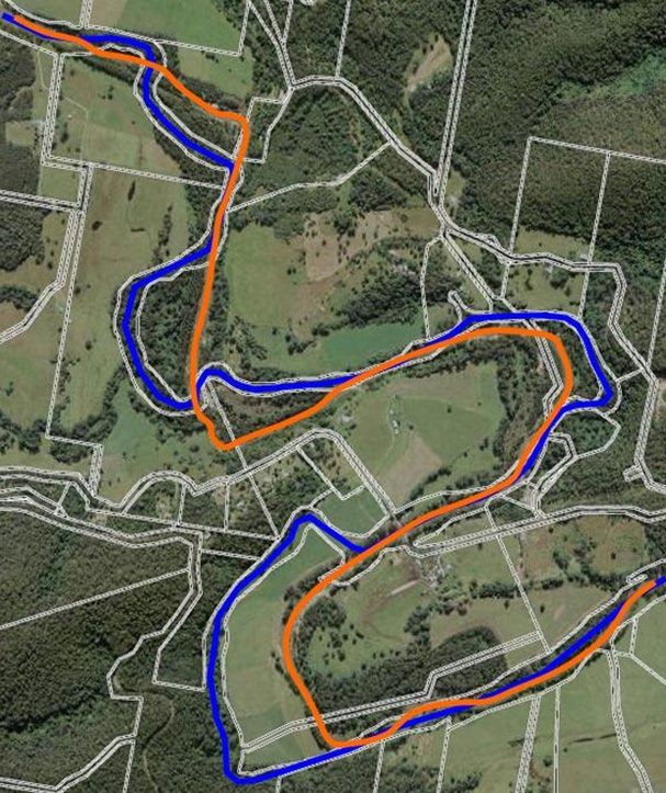
Proceedings of the APAS Webinar Series 2021 (AWS2021)
                                       24 March – 30 June 2021

high tides “between” ordinary spring and neap high tides. So, the ordinary spring and neap must
be excluded from the calculation because the word ‘between’ does not mean including. But
what of the non-ordinary spring and neap high tides, are they to be included or excluded? Which
are the non-ordinary spring and neap high tides? Because there is only one spring and one neap
tide in each tidal set, does that mean that these are the ordinary tides? Or does the height of the
spring or neap tide make the distinction between ordinary or non-ordinary. If so, does that mean
that some tide cycles cannot be used because the spring and neap tides are of the non-ordinary
type? There are just no answers to these questions. If there are no answers to resolve the
uncertainties, then how can there be a definitive result for the boundary marked as MHWM on
cadastral plans?

Examination of how the MHWM came into existence must also be given due consideration.
This definition was brought to the surveying industry in 1854 with the English court case
Attorney General v. Chambers. This case was not about how boundaries were determined on
the surface or what the surface conditions were like but rather the extent to which coal miners
could extend underground out into the sea. The Attorney General took the stance that the
interest of the Crown extended to the high water mark or the extent of the spring (highest) tides.
The miners, however, took the view that the Crown’s interest did not extend beyond the neap
(lowest) tides (Blume, 1995).

The judges, in their deliberation, considered that the land over which only the spring tides
extended was for the most part “dry and maniorable”. Even though the land would not always
be covered in salt water, it supposedly could be used for some things. Cattle might browse
through the salt grass marshes and mangroves, but vegetables or other crops would not likely
be grown. In essence, the farming land might have only extended to the high water line, but the
miners wanted to go further because there were valuable resources to be gained. The result was
a compromise between the two opponents, a point mid-way. The boundary given to the coal
miners is also not ambulatory. Coal was dug out of the mine to the limit of what was determined
as the line of MHW at that time, and there it remains. Should the line of MHW progress inland,
the mine company was not about to fill in the mine or give back the coal. The boundary
remained static.

2.1.2 Other Tidal Boundary Entities

The legislation for tidal boundaries supposedly tries to make some degree of conformity as to
which entity should be regarded as the land boundary. At clause 51 of the Surveying and Spatial
Information Regulation 2017, it says:

   For the purposes of preparing a survey, in any previous survey plan or other description
   of land:
   (a) a reference to high-water mark is taken to be a reference to mean high-water mark,
   and
   (b) a reference to, or description of, a boundary that abuts tidal waters is taken to be a
   reference to, or description of, a boundary that abuts mean high-water mark

And at the end of the clause in almost a foot note:

   unless a contrary intention appears.

                                               158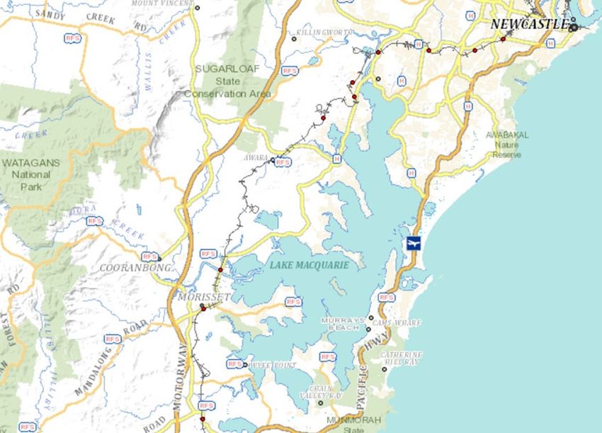
Proceedings of the APAS Webinar Series 2021 (AWS2021)
                                       24 March – 30 June 2021

It may have been the intent of this legislative clause to bring some certainty as to what entity
constitutes a tidal boundary, but it does the opposite. This clause calls for any other identifier
or description to call the boundary MHWM. And if you want to know what the MHWM is, then
refer back to the definition and you will find that it is an entity that is not a boundary line (see
Figure 1). This is a curious circular exercise into uncertainty.

The clause also does not change the physical situation where there are tidal boundaries that are
not the mark of MHW. The legislation might want the surveyor to call them MHWM but that
does not change the fact that they are not. The tidal limit is an example which is determined by
the highest tides, or loosely, the mark of high water. The extent either the high water or MHW
reach up an estuary will depend on the gradient of the upper reaches. The distance between the
MHW limit and the tidal limit will vary, but the land that abuts this area is still abutting tidal
waters. The boundary of such land is thus the mark of high water, not the mark of MHW as
clause 51(b) would have you determine it (Figure 2).

                           Figure 2: Tidal limit Mean High Water uncertainty.

This brings up the situation with plans that label the tidal boundary high water mark. The
legislation would have the surveyor determine the boundary at the MHWM, but the question
still remains: Does the land extend that far into the tidal estuary? Without doubt there is a
difference in water levels between high water and MHW. Where the two entities intersect the
shore, there will be a distance separating the two lines. High water will reach further up the
shore than MHW. Whether this legislation has the effect of changing the boundary location and
consequently the extent and area of the land, or even if it is legal to do so, is uncertain. Because
the change took place suddenly by a purposeful act upon the passing of the legislation, the
application of the doctrine of accretion and erosion would prevent such a change being adopted.
There is also the uncertainty as to whether the Attorney General v. Chambers decision of 1854
is retrospective. It may well be that titles issued to high water prior to the ruling could retain
the high water limit.

If the meanings of words in the English language are also to be adhered to, then land that has a
description “abutting” tidal water should have no part of the tidal reach within the bounds of
the land. Abutting means beside and there is no presumption that there is any partial inclusion
of that which is beside or abutting. The boundary should thus be the mark of high water and not
the mark of MHW. Use of MHW would result in part of the tidal regime being included in the
title and the land would no longer be abutting tidal water.

                                                 159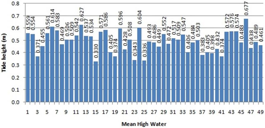
Proceedings of the APAS Webinar Series 2021 (AWS2021)
                                       24 March – 30 June 2021

Attorney General v. Chambers may have limited the English Royal prerogative of the seashore
to the line of MHW against that shore but legislation, title descriptions and some practices have
not caught up with this. The change to MHW may not have resulted in the change in location
of some land boundaries that were previously abutting or extending only to the mark of high
water. The application of clause 51 of the Regulation does attempt to affect a location change
in many instances, but at the same time it contradicts itself by saying unless a contradictory
intention appears. Is not the use of the identifier high water mark or the fact that only high water
could occur in some sections of the tidal reach a contrary intention? It is all very uncertain.

2.2 Non-Tidal Boundaries

The legislative dictates that govern the derivation of non-tidal riparian boundaries possibly
contain greater uncertainties than those surrounding tidal boundaries. It could even be
concluded that derivation of non-tidal boundaries has no degree of certainty of position and that
there is conflict as to what that boundary should be identified as.

2.2.1 The Bank

The legislative definition of a non-tidal boundary initially comes from the Crown Lands Act
following the 1931 amendment to the Crown Lands Consolidation Act 1913 adding section
235A (section 13.3 in the current Crown Lands Management Act 2016). This amendment
brought into being in New South Wales the definition of the bank, being the identified non-tidal
riparian boundary for Crown Grants. Unfortunately, the definition wording is both convoluted
and contains unanswerable uncertainties:

   Bank means the limit of the bed of a lake or river.
   Bed means the whole of the soil of a lake or river including that portion:
   (a) which is alternately covered and left bare with an increase or diminution in the
       supply of water, and
   (b) which is adequate to contain the lake or river at its average or mean stage without
       reference to extraordinary freshets in time of flood or to extreme drought.
   Lake includes a permanent or temporary lagoon or similar collection of water not
   contained in an artificial work.
   River includes any stream of water, whether perennial or intermittent, flowing in a natural
   channel, and any affluent, confluent, branch or other stream into or from which the river
   flows.

Most of the wording is quite straight forward but there is no qualification as to what is an
“extraordinary freshet” or an “extreme drought”. These terms are left to the contemplation of
the practitioner. The stage to which the river or lake must rise to become an extraordinary
freshet is not determinable. The conditions of extreme drought are even more uncertain.
Although during times of drought, lake levels and river flows diminish, the situation could
occur where a river flowing through a region in drought has its origins in a region having good
rainfall and is not in drought. The river might well be flowing through the drought region with
good vigour. The conditions of drought might not necessarily correlate to river or lake stage,
leaving an uncertainty as to what the term actually refers to or what the measure of the stage is.
Thus there is a degree of uncertainty as to what stages of a river or lake over or under an
undetermined amount must be excluded so as to determine the mean stage.

                                                160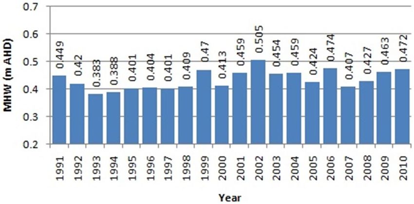
Proceedings of the APAS Webinar Series 2021 (AWS2021)
                                      24 March – 30 June 2021

2.2.2 Not The Bank

If the Crown Lands definition was not enough of an issue, the legislative writers had to have
another go at providing a non-tidal boundary definition by inclusion of a similar narrative in
the Surveying and Spatial Information Regulation 2017. Unfortunately, they did not do a
straight copy from the Crown Lands definition but had to change things so that surveyors can
be left with conflicting and uncertain directions:

  (Bank: The term ‘bank’ was excluded as part of the definition.)
  Bed in relation to a lake or stream, includes any portion of the lake or stream:
  (a) that is alternately covered and left bare with an increase or diminution in the supply
      of water, and
  (b) that is adequate to contain the lake or stream at its average or mean stage without
      reference to extraordinary freshets in time of flood or to extreme drought.
  Lake includes a permanent or temporary lagoon or similar collection of water not
  contained in an artificial work but does not include tidal waters.
  Stream includes any non-tidal waters that are not a lake.

To add to the uncertainty of what is an extraordinary freshet or an extreme drought, there is no
identifier for what the non-tidal boundary should be called. The wording also changes what is
considered a stream. In the Crown Lands version, the stream must have a natural channel.
However, in the Regulation version, any channel not a lake can be included which would
suggest that an artificial drainage line could be considered a stream and thus form a riparian
boundary.

If a survey is to be conducted for Crown Land involving a non-tidal riparian boundary, then the
boundary should be called “the bank”. However, to satisfy the Surveying and Spatial
Information Regulation, that tag must be removed, leaving the surveyor in an uncertain state of
nowhere.

2.2.3 Other Non-Tidal Boundaries

In non-tidal riparian boundaries, the bank is not the only entity to be used as the boundary. A
centre line is sometimes considered, but this involves determining the extent of the stream and
taking the middle line so that is essentially little different from the property boundary on a
single side. The surveyor just has to locate both sides before the middle can be determined.
Other identities such as the extreme margin, the high bank and the low bank have also been
used. Much older surveys or descriptions of land parcels did not always give any indicator as
to what the riparian boundary was. The boundary was simply given as the stream or abutting
the stream.

Use of a defined bank as boundary only came into existence in 1931. It is unclear what the non-
tidal riparian boundary was prior to that date. The NSW Regulations for Licensed Surveyors
1914 describe the boundary to be a fair limit of the channel, of the watercourse, excluding also
shingle beds from the land with pegs set back from an unstable bank and a distance given to the
channel limit. What is the channel or what is the limit is not stated, so it was left up to the
surveyor to make a guess. The NSW Regulations for the Guidance of Licensed Surveyors 1886
and 1864 were even less informative. Thus the non-tidal riparian boundary prior to 1931 could
be anything or be described as anything and located anywhere within or abutting the river
environment. A highly uncertain state indeed.

                                              161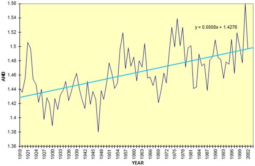
Proceedings of the APAS Webinar Series 2021 (AWS2021)
                                       24 March – 30 June 2021

The Surveying and Spatial Information Regulation 2017 in clause 51 tries a similar renaming
of the boundary entity as with tidal waters. It is also within this clause that a possible name of
the non-tidal boundary can be inferred:

   For the purposes of preparing a survey, in any previous survey plan or other description
   of land:
   (c) a reference to a bank of a lake or stream is taken to be a reference to the limit of the
        bed of the lake or stream, and
   (d) a reference to, or description of, a boundary that abuts a lake or stream is taken to be
       a reference to, or description of, a boundary that abuts the limit of the bed of the lake
       or stream.

And the footnote:

   Unless a contrary intention appears.

It is uncertain as to what name the non-tidal boundary should be given as the legislation clause
does not give one. Instead, by inference from sub clauses (c) and (d), the name that could be
used is the descriptor of how to find the boundary, which is “the limit of the bed”.

Changing the name of the boundary from previous plans from what is shown on those plans
can give an uncertain outcome. The extreme margin is just that, the greatest extent to which the
stream reaches across its width, causing the land to abut the stream (i.e. it does not include any
part of the stream). The bank, for want of a better name, in cadastral purposes is much lower
down within the stream environment (Songberg, 2002, 2012). For a land parcel with a riparian
boundary identifier such as extreme margin or an identifier that causes the land to abut the non-
tidal stream, by insistence of clause 51(d) the boundary should be identified as the cadastral
bank and not the identified boundary. Calling the boundary by another name does not change
the fact that the two locations are different and there could be substantial land in between
(Songberg, 2020). The owner of such land might have issues with any boundary change of this
nature.

The use of any other identifiers that are somewhere else in the stream environment, such as the
back of the shingle bed, may have been used in the past to give a clearer location for the
boundary. These other identifiers are not mentioned in clause 51 other than the possibility of
them being considered as contrary intentions. By rights then, it should be possible to retain
these other boundary identifiers as the boundary which would also include the extreme margin
or the top of the high bank. The contrary intentions part of clause 51 may have a slightly
different effect on non-tidal boundaries compared to the effect on tidal boundaries, but it still
creates some uncertainty.

2.2.4 Other Ad Medium Filum Aquae

The simple explanation of Ad Medium Filum is that the title of land that runs to a non-tidal
stream is likely to enjoy the presumption of title to the middle thread of that stream unless
otherwise stated. However, that condition will only occur if the grant was prior to the
reservation of all beds of streams from 3 May 1918 in the eastern and central divisions of the
state and from 31 May 1935 in the western division.

                                               162
Proceedings of the APAS Webinar Series 2021 (AWS2021)
24 March – 30 June 2021
This sounds simple, but there are a number of uncertainties that exist that will make location of
the possible centre thread alignment an uncertain probability. Only in the western division and
only after 1931 was the riparian boundary determined to be the bank. Prior to 1931 in the
western and prior to the reservation in the eastern and central divisions the land boundary is
uncertain and could have any entity. The Surveying and Spatial Information Regulation 2017
in clause 51(d) would have the boundary called and located at “not the bank” but that does not
necessarily make it so, nor would it have been at the time of grant. If the land boundaries on the
other side of the stream were different entities, then what would constitute the centre thread?
Would it be the mid-point between the two different entities, or would the two entities need to
be the same, otherwise there could be an unequal distribution of the stream? Determining the
centre using one entity from one side and another entity from the opposite side could even result
in an overlap. Whatever the outcome, determining the position of the centre thread line is likely
to be an uncertain task.
2.3 Lake or Not a Lake, Stream or Not a Stream
It has already been shown how legislation conflicts can result in uncertainties as to what should
be the appropriate terminology in identifying a riparian boundary. Legislation conflicts can go
further, and in this instance an uncertainty is created when it comes to identifying the body of
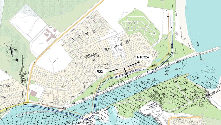
water associated with a riparian boundary. In NSW, just south of Newcastle on the Central
Coast, is a large body of water known as Lake Macquarie (Figure 3). The Geographical Names
Board of NSW identifies the body of water as Lake Macquarie and gives it a designation of a
lake. The Crown Lands Management Act 2016 agrees that this body of water is a lake. In section
13.3(9) it states that “lake includes a permanent or temporary lagoon or similar collection of
water not contained in an artificial work”.
Figure 3: Lake Macquarie.
163
Proceedings of the APAS Webinar Series 2021 (AWS2021)
                                        24 March – 30 June 2021

The Surveying and Spatial Information Regulation 2017, because it was not a straight copy but
instead changed, disagrees that this body of water is a lake. In clause 44, it states that a “lake
includes any permanent or temporary lagoon or similar collection of water not contained in an
artificial work, but does not include tidal waters”. Considering that Lake Macquarie is
considered tidal and the riparian boundaries along the foreshore are generally the MHWM, it is
uncertain why the Regulation would not designate it as a lake. It could be that the lake does not
have its own individual tidal regime like the sea. The ebb and flow of the tide originates from
the sea as the water within the lake rises or falls as the tide flows in or out of the entry channel.
The lake in this respect is an inlet of the sea and thus possibly not a lake.

The same applies to streams. In the Crown Lands realm, a stream (or river), perennial or
intermittent, occurs in any natural channel. With perennial meaning lasting, enduring or
continually reoccurring, this would include the tidal stretches of such streams. In the Regulation
realm, the stream cannot be within tidal waters. Like the lake, tidal river systems are really an
inlet of the sea so that under the Regulation they are not a stream (or river).

Where does that leave the surveyor if not in an uncertain state? Non-tidal riparian boundaries
can be called a bank in one legislation but not another, and now a tidal body of water can be
identified as a lake or stream in one legislation but not in the other. It is all a bit uncertain, but
then what is in a name?

3 FINDING THE RIPARIAN LINE

Legislation has not provided the practitioner with any degree of certainty as to what a riparian
boundary is, where it is, or what its designation is. Surveying practices in determining riparian
boundaries have instead evolved over time to where the processes are comfortably understood,
followed and accepted by most. Those practices, however, do not comply with the dictates of
the legislation (Songberg, 2020). With the legislation so full of uncertainties, it is uncertain that
surveyors could adhere to the letter of the law. It is much easier to follow the well-established
practices.

Adopting such a protocol, however, does not guarantee certainty in the determination. Slightly
different techniques will produce different results with sometimes surprising variations.
Consistency, even in a single protocol, will still produce variances in results so the
determination can become inaccurate and uncertain (Songberg, 2005, 2015). There are also the
variances in nature, which are not easy to follow or measure, causing a determination of the
riparian boundary to become very uncertain. Then there are the artificial constraints that fix a
boundary in time. The landward reserve boundary is such an example and locating one may
require an extraordinary time-travel style investigation (Songberg, 2007).

3.1 Mean High Water Mark

Despite the vagrancies of the legislation in naming the tidal boundary line and instead giving
the name MHWM to the tidal plane, the boundary line that is expected by industry must still be
determined. If a surveyor is to determine the line along the foreshore that is intersected by the
MHW, then the MHW level must first be ascertained. There are several ways to achieve this.
Certainty and accuracy of the outcome is to be expected, however, the search for the right
method leaves its own uncertain results.

                                                 164
Proceedings of the APAS Webinar Series 2021 (AWS2021)
24 March – 30 June 2021
3.1.1 Time Dependence
In attempting to follow the dictates of the legislative definition, a 7-day period of observation
of high tides is required to determine the mean (Songberg, 2020). This is also the observation
extent envisaged by the judges in Attorney General v. Chambers. A quarter of a lunar revolution
and 3 days out of 7 being just a couple of the supportive phrases used to support the decision in
the court case (Blume, 1995).
Because the tides vary considerably throughout the year, the short observation period will
produce considerable variations in the value of MHW between periods (Figure 4). In any 12-
month period, the variation in level of MHW could be as much as 0.35 m. Such a difference
could result in quite a discrepancy in the lateral position of the land boundary in two adjacent
surveys. Neither is wrong, but there would be questions asked as to why the difference. There
would also be a level of uncertainty as to the validity of such determinations. Figure 4 also
shows that there could even be a variation in level of 0.25 m from one week to the next. Such
a level of uncertainty would not be acceptable to anyone, but it is what legislation and legal
precedence have thrust upon us.
Figure 4: Legislation length observation sets for Mean High Water over a 12-month period (quarter lunation, i.e.
7.38 days).
Such an observation set has likely never been undertaken as guiding practice documents, e.g.
NSW Regulations for Licensed Surveyors 1914 and the Manual for the NSW Integrated Survey
Grid (Lands, 1976), suggest a period of a month (1 lunation), or even better a year, to obtain an
accurate result for MHW. No matter which observation period is used to obtain a mean, an
accurate determination is uncertain as each method will produce variances between one
observation period to the next (Songberg, 2005, 2015). The uncertainties do not come from the
observation techniques but instead from the vagrancies of the tide.
The variations across longer periods of observations do diminish considerably. Applying a
lunation length period (29.53 days), the difference over a year is reduced to only 0.15 m (Figure
5), based the same dataset as used for Figure 4. However, the result could differ between
datasets. It is quite possible that such a difference could result in two surveys side-by-side but
one month apart arriving at two entirely different positions of the line of MHW on the common
165Proceedings of the APAS Webinar Series 2021 (AWS2021)
24 March – 30 June 2021
boundary. Again, neither is wrong but the results create a climate of uncertainty in a situation
where consistency would be expected.
Figure 5: Lunation length (29.53 days) observation sets for Mean High Water over a 12-month period.
Lengthening the period of observation out to one year does not remove the probable variations
from one year to the next (Figure 6). The greatest difference across the 20-year period is still
0.12 m, and there could still be a noticeable difference between successive observation sets.
Extending the observation period out beyond a year does not remove the variances, nor will
doing so significantly reduce the probable difference from one period to the next. Neither does
extending the observation period provide any advantage as other factors such as sea level rise
start to take effect and influence the outcome (Songberg, 2015, 2016).
Figure 6: 1-year long observation sets for Mean High Water over a 20-year period (Port Macquarie).
A 19-year moving average (18.6-year lunar nodal cycle) is used at times to determine various
tidal information sets (Couriel et al., 2012; ICSM, 2017). Such a period may be valid or essential
for some purposes, but for cadastral surveying the inconsistencies become evident when
examining the changing sea level trend. Sea level change is evident within the period and
holding the mean beyond the period creates greater uncertainty when compared to the
extrapolated sea level change (Figure 7) (Songberg, 2015, 2016). As the surveyor would always
use the mean after the period, the value of MHW use would always be too low. The longer the
time for the survey is after the period, the greater the discrepancy.
166Proceedings of the APAS Webinar Series 2021 (AWS2021)
24 March – 30 June 2021
The effects caused by changes in sea level become even more apparent when data is viewed
over a longer period. Figure 8 shows that sea level change is an ongoing process that cannot be
ignored if accurate MHW levels are to be obtained for cadastral purposes. Even though a linear
trend is shown, it may not be appropriate as there may be different rhythms that may have to be
considered. Taking smaller segments, such as 19 or 20 years, still produces variations from one
period to the next with the expected variation in results being similar to the other time periods.
Figure 7: The effects of sea level change on long-term means (Port Macquarie) (Songberg, 2016).
Figure 8: Trend in sea level change at Fort Denison, Sydney (Songberg, 2015).
167Proceedings of the APAS Webinar Series 2021 (AWS2021)
24 March – 30 June 2021
Where this leaves the surveyor in the search for certainty is anywhere but certain. No matter
which time period of observation is considered, the results remain uncertain. There is no
repeatability, and although the outcomes are technically correct within themselves, there is an
apparent disagreement between each determination which could result in conflict. There is also
no consistency between the different time period observation sets as each will produce a
different result. The simple outcome is different data equals different results, and the resulting
uncertainty is not in what the surveyor has done but within the tides themselves.
3.1.2 AHD Levelling
By far the most common method used to determine the MHW surface level at any survey site
is to relate it to the tide gauge network, which is in turn related to the Australian Height Datum
(AHD). Given the AHD level of MHW, even though it is one not compliant with the terms of
the legislative definition (Songberg, 2020), and knowing the tidal plane characteristics, it is
presumably a simple matter of running a levelling traverse along the foreshore to determine the
appropriate line. This sounds good, but is the outcome certain? Combine the characteristics of
the AHD network with tidal plane idiosyncrasies and the answer is no.
Across Lake (or not Lake) Macquarie in Figure 3, it is approximately 7.5 km as the crow flies
from Swansea on the east to Wangi Wangi on the west. Whichever way around, the road
distance is approximately 40 km. Although widely used, the AHD network is not recommended
for projects greater than 10 km in length and water might not flow in the direction suggested
by AHD levels (Brown, 2019). The AHD levelling network is made up of a combination of 1st,
2nd and 3rd order levelling runs (with network adjustments). So, for the 40 km length of the
AHD traverse around the lake, the allowable misclose is ±25 mm (1st order or 4√k), ±51 mm
(2nd order or 8√k) or ±76 mm (3rd order or 12√k). Theoretically, the slope of the water surface
across the lake from west to east could be either uphill or downhill by at least 25 mm. However,
the vagrancies of the tides themselves may produce a different result.
As with the vagrancies of finding the MHW level, the tidal gradients exhibit similar
characteristics. Figure 9 shows the changes in the tidal gradient across Lake Macquarie over
time. The AHD variance is small compared to the variances in the tidal gradient. Similar
changes over time occur along a tidal stream such as the Hunter River (Figure 10).
Figure 9: East-west tidal gradient across Lake Macquarie (1997-2000).
168Proceedings of the APAS Webinar Series 2021 (AWS2021)
24 March – 30 June 2021
Figure 10: Tidal gradient along the Hunter River (2000-2005).
The distance between the Stockton Bridge and the Belmore Bridge at Maitland is 28 km as the
crow flies. It is 32 km by road, the distance the AHD levelling would have had to run, and 56
km by river. As these distances are far in excess of the recommended limit for use of AHD in
determining which way water will flow, it reduces the certainty of AHD to provide reliable
relationships along the tidal gradient. When combining the uncertainty of establishing a
consistent level of MHW with the distance uncertainty of AHD and possible local anomalies
within the AHD network (McCubbine et al., 2019; ICSM, 2021), there would need to be some
consideration as to whether or not the tidal surface flows downhill towards the river entrance
to the sea. Is the rise in the river surface at Raymond Terrace (see Figure 10) a consequence of
the flow characteristics of the river (the Williams River meets the Hunter at this point) or is
there some anomaly in the AHD network creating the hump? Can the determination of MHW
anywhere along the course of the river be certain or is any determination restrained to a localised
phenomenon? Unless the AHD-determined components of riparian boundary surveying can be
pulled along into adjusting for the future by proposed new techniques in advanced Global
Navigation Satellite System (GNSS) levelling (Brown, 2019; McCubbine et al., 2019), then
there are possibly no answers. The AHD levels of the tide gauge network need to be verified or
updated to get more certainty.
3.1.3 Other Methods
Other methods of determining the location of the tidal boundary, such as relating to mangrove
positioning, the tops of cobbler’s pegs or the oyster ring on a post, or taking an instantaneous
observational assessment, probably do not need mentioning as to the certainty of these methods.
The results are of course just as uncertain as is the accuracy.
3.2 The Bank and Not The Bank
Legislation has left the surveyor in an uncertain position as to what to call the non-tidal riparian
boundary. It is either the bank, if under the Crown Lands Act, or possibly the limit of the bed
if the Surveying and Spatial Information Regulation is to be adhered to. Either way, the
determination of this uncertain named entity must be carried out in the same manner. The
average or mean stage must be determined, setting aside the uncertainties in establishing the
stages associated with non-ordinary freshets and extreme droughts.
Determining the mean stage requires measurements of stream flow over an extended period of
time, preferably decades. With adequate data at hand and the application of some mathematics,
it is possible to determine the mean stage (Songberg, 2002, 2012). Australian river and stream
169Proceedings of the APAS Webinar Series 2021 (AWS2021)
24 March – 30 June 2021
flows change with the vagrancies of nature. There is no discernible regular cycle (Figure 11),
so it takes an extended set of measurements to determine the mean. A short period of
measurement, using similar time scales as to those used in tidal determinations, will only obtain
a heavily biased result. The observation duration of Figure 11 is only 30 years and possibly is
only barely long enough to get a meaningful result. However, surveyors do not have 30 years
or more to observe, or the resources to set up a stream gauging station.
Figure 11: Typical Australian non-tidal stream characteristics, showing the maximum daily gauge height of the
Manning River at Killawarra (Songberg, 2012).
It would be possible to utilise data from an established gauge (Songberg, 2002, 2012), but they
are few and far between and likely nowhere near or even on the same stream as the survey. The
surveyor is left with only one alternative, i.e. walk down to the stream on the day of the survey
and have a guess, educated or not (Songberg, 2020). The result is highly uncertain and not likely
to be the actual bank as required by the legislation. Having a guess has no basis in surveying
and guessing at what the mean stage is on a river profile is impossible. It is not until some form
of statistical analysis is undertaken that there can be an appreciation of where the correct stage
is located across the stream profile (Songberg, 2012) (Figure 12).
Figure 12: Typical non-tidal stream stages, showing the Manning River at Killawarra (Songberg, 2012).
170Proceedings of the APAS Webinar Series 2021 (AWS2021)
24 March – 30 June 2021
Any other result is an uncertain one. With guess work being the most likely method utilised in
the past throughout the State to establish non-tidal riparian boundaries, the extent of properties
along non-tidal streams has been moved from a state of certainty to one of uncertainty.
Determining the mean stage of non-tidal lakes is just as uncertain as streams. Gauges only exist
on some lakes, so without one, and one with long-term data, there is no way of determining the
mean stage. Unlike many streams, there is often a distinctive change in the landscape that will
give a natural appearance to the edge of the lake. Inland lakes might have a natural limit
determined by an overflow channel. Intermittently Closed and Open Lakes and Lagoons
(ICOLL) extents may be more influenced by the tidal reach during times of being open to the
sea than water levels during times the bar is closed. These perceived natural extents are likely
to have no relevance to the cadastral requirement of the limit of the bed but are more likely the
choice of surveyors.
Inland lakes could be dry for extended periods and only fill to capacity after substantial rains.
ICOLL water levels can also be as low as bare sand at low tide if the lake is open to the sea.
But the upper extent is more likely to be determined by an artificial limit and manual opening
when the water is deemed to be too high. Applying the definition requirements to such a stage
regime may produce unintended results. The extent of non-tidal lakes is thus likely to be
determined by any other visible factors observed at the time of survey rather than the dictates
of the definitions.
3.2.1 Artificial Lakes
It should be stressed that determining the extent of an artificial lake, if such a thing exists in the
cadastral realm, does not follow the same rule as natural lakes and does not have the
uncertainties associated with natural lakes. The limit of an artificial lake is determined by the
height of the constructed overflow channel or dam wall, whichever creates the 100% full lake
level. The various stages have no relevance on determining the limit of the lake, see Yeomans
v. Peters (1895) 16 NSWR (Eq) 197 (Ticehurst, 2000).
But is the body of water a lake or not a lake, as far as riparian boundaries are concerned? Both
the Surveying and Spatial Information Regulation and the Crown Lands Act agree that a lake
is a body of water “not contained in an artificial work”. The Yeomans court case determined
how the boundaries of an artificial lake were to be found. If considered within the exact wording
of the law and the outcome of the court case, then a dam across the stream would result in a
lake contained “by” an artificial work and not one “in” an artificial work. Such a lake would
constitute an artificial lake and have a riparian boundary. If, on the other hand, the artificial
work surrounded the body of water, then it would not be a lake and could not have a riparian
boundary. Is such a consideration certain? Unfortunately, the answer is uncertain.
4 CHANGES TO RIPARIAN BOUNDARIES
Riparian boundaries by the natural order of things move. They ambulate over time. The rate at
which these boundaries move is dictated by the forces of nature. In the cadastral realm,
however, artificial dictates and rules go against the natural order, creating disparities between
the cadastre and nature. Those rules create uncertainties and situations can occur where the
location of the cadastral boundary becomes indeterminate despite the natural boundary being
highly visible. Unless the changes are evaluated and dealt with consistently, the results can
171Proceedings of the APAS Webinar Series 2021 (AWS2021)
24 March – 30 June 2021
produce uncertainties within the cadastre (Songberg, 2004, 2007) and even loss of integrity
(Songberg, 2019), so what is shown as a boundary might not be one.
The most obvious aberration against ambulatory change is within non-tidal lakes. The
boundaries of these do not change. From the Crown Lands Management Act 2016, section
13.3(3), “the doctrine of accretion does not apply, and never has applied, to a non-tidal lake”.
The only uncertainty with this is if the lake were excised from freehold lands. As this rule was
introduced under the Crown Lands Act for the alienation of Crown Lands, it is uncertain if the
same condition would apply in a freehold situation unless a similar stipulation was to be made.
The Surveying and Spatial Information Regulation 2017, however, seems to side with the
opinion that the rule does apply as in clause 49(1): “If, since the date of a previous survey, there
has been a change in the position of the bank of a lake forming a boundary of land to be
surveyed, then, in any subsequent survey, the position of the bank, as it was before the change,
must be adopted.” This clause, however, only relates to old existing boundaries, not new ones,
so the uncertainty still hangs.
Elsewhere in the riparian realm, the changes to the cadastral riparian boundaries are determined
by application of the doctrine of accretion or erosion. The doctrine asserts that should the
change be natural gradual and imperceptible, then the change should be adopted. It does not
matter if the change creates an addition to the land (accretion) or subtraction from the land
(erosion), the doctrine applies equally. The converse is that if the change is not natural or
gradual, then the riparian boundary does not change, even though the physical boundary has
substantially shifted. The riparian side of the boundary must also be given equal consideration
as there will be some owner, be it the Crown or a private landowner.
Determining whether the change is gradual or not can be an exercise in uncertainty. In tidal
waters, the ebb and flow of the tide is one changing force that is always there and could be
expected to be the instrument of change. But when confronted with downstream-facing land
spits (Songberg, 2007), or when no changes occur without water level rises occurring above
tidal flow (Songberg, 2004), then consideration would have to be given to the major change
factor being floods arising from high rainfall events upstream. This situation could be the case
in the greater reach of the tidal stream, and it is only down in the lower reaches where it seems
that there is a continual build-up of sand clogging the channels that gradual change occurs.
Even the gradual sand build-up is not the whole story as it is from time to time pushed back out
to sea when there is a major flood event within the stream.
To add further complexity, in 2002 the Coastal Protection Act 1979 was amended with the
addition of section 55N with the modified doctrine of accretion and erosion. The impact of this
was that within the coastal zone the area of adjacent land could not increase if the accretion is
not likely to be indefinitely sustained by natural means, or public access to the waterfront will
or is likely to be restricted. This could leave many riparian boundaries left in the undecided pile
uncertain of how or if they can be resolved.
Rising sea levels have been well documented and are even evident in 20-year tidal records
(Songberg, 2015, 2016). To say that an increase in land due to gradual accretion was indefinitely
sustainable would be impossible, given that one day the rising sea will eventually cover at least
the lower parts of the land, unless of course the trend reverses or the land also rises.
Gradual change must also follow the criteria that the change cannot be noticed from day to day,
week to week or month to month. A change might be noticeable over a longer period, say a
172Proceedings of the APAS Webinar Series 2021 (AWS2021)
24 March – 30 June 2021
year, but it cannot be considered as gradual unless it can be proven that the process had been
ongoing throughout that time and not observable during the shorter time spans. An event that
causes change on a yearly basis is not considered gradual as a consequence of several court
cases (Ticehurst, 2000). With higher than normal flow events being the dominant factor in
changes to river banks and much of the upper tidal estuaries, the frequency of when those flows
occur has a telling factor on whether or not they form part of the gradual change. Statistical
review of stream flow data indicates that these flows only occur on average 1-year to 1.5-year
intervals (Songberg, 2002, 2012). Rainfall events that are sufficient to create such a rise do not
conform to the statistical timetable (see Figure 11) and in reality occur at random intervals as
so do the higher stream flows. Such rises could occur a month apart or 10 years apart. What this
means is that such events, either the statistical average or the random occurrence, places the
cause of change outside the gradual acceptability. It also pushes the concept of gradual change
in much of our river systems to a very uncertain possibility.
One cause of change process that is certainly gradual is the steady rise in sea level. With the
process evident over a 20-year recording span (see Figure 7) and undeniable over longer records
(see Figure 8), the seashore will gradually encroach into the land. Whatever ownership is
attributed to the wet land encompassed by tidal waters, that ownership has the same rights of
gradual increase as does the dry land counterpart. So, by rights the tidal riparian boundary
should gradually move into the land and the land area diminish. Some agree with this (Corkill,
2013) and some do not (Barham, 2016), resulting in the ambulatory nature of the cadastral tidal
riparian boundary possibly limited and in a state of uncertainty.
The limitation and uncertainty revolves around the artificially defined right-line boundaries
such as those bounding a regular shaped land parcel or the landward boundary of a foreshore
reserve. Corkill (2013), based upon court decisions such as Environmental Protection Authority
(EPA) of New South Wales v. Saunders (1994), cites justice Bannon who deemed that the
allotments, being below water, could not be occupied and had been effectively extinguished.
The opposing view considers the right-line boundary do be inextinguishable so that the
ambulatory riparian boundary could not pass across one, with the decision in McGrath v.
Williams (1912) being given as reason. The decision in McGrath v. Williams determined where
the landward boundary of the foreshore reserve should be located, offset to the position of
MHW at the time of creation (granting of the land). It is held that, as a consequence of that case,
the landward boundary, being a defined boundary, is not a riparian boundary and is not subject
to the doctrine of accretion and erosion (Ticehurst, 2000). This would imply that the riparian
boundary could not pass beyond the right-line boundary even though it physically does.
So, who is right and who is wrong? Did McGrath v. Williams really determine that the
ambulatory boundary could not migrate across the right-line landward reserve boundary, or did
the decision only determine where the reserve should be located, at a particular point in time?
The reserve does not migrate parallel with the ambulatory boundary; it gets eaten away. But
what happens to the right-line boundary? Does it stay or does it also get eaten away with the
rising sea, just as the next right-line bounded land parcel? Do the rights of the owner of the sea
get curtailed by an artificial line? There does not seem to be a definitive answer to the situation,
so a resolution remains uncertain.
The effects of a rising sea can also be very noticeable when storm-driven waves and tidal surges
eat away the dune behind the beach, sometimes toppling homes into the ocean. In this instance,
under the doctrine of accretion and erosion, the riparian boundary does not change even though
the sea marches inland and the land is physically lost to the sea.
173Proceedings of the APAS Webinar Series 2021 (AWS2021)
24 March – 30 June 2021
The situation in non-tidal lakes is a complete contrast. From the Crown Lands Acts, it is deemed
that the doctrine of accretion and erosion does not and never did apply to non-tidal lakes. So,
wherever the riparian boundary was determined that is where it remains, no matter if the
physical line changes for whatever reason. The position of the riparian boundary, however,
comes down to the choice of the surveyor at the time. That choice would have been a subjective
guess and not based on any stage measurements or a MHW determination in an ICOLL. The
choice of different surveyors might not necessarily be the same, with the result being that non-
tidal lake boundaries are not related to the average or mean stage and might not be consistently
positioned around the shoreline. These boundaries thus remain in the uncertain realm.
Determining whether or not the riparian boundary, tidal or non-tidal, changes is never an easy
or straight-forward exercise. Outcomes might have inconsistent consequences on both the
riparian and land zones. A movement on a cadastral perspective might be completely different
to the physical perspective. As Figure 13 illustrates, the physical stream and the cadastral stream
might be some distance apart (Songberg, 2016). As the sea swallows the land, artificial
boundary lines might cause a disparity between the cadastral and physical properties (Figure
14). Could a boater travel across someone’s backyard if one principle applies or not if another
is upheld?
Figure 13: Cadastral stream (blue) vs. physical stream (orange).
174Proceedings of the APAS Webinar Series 2021 (AWS2021)
24 March – 30 June 2021
Figure 14: The march of the sea vs. right-line boundaries.
The outcome in riparian boundary cadastral change is not always certain and differing results
could change the movement regime on either side of the river. The right-line boundary dilemma
might also be a factor, with the result of the uncertainties being that a cadastral river might
actually disappear and cadastral land properties potentially overlap (Figure 15) (Songberg,
2004).
Figure 15: The potential for rivers to disappear in a cadastral sense.
Riparian boundary change can also be mismanaged in both assessment and recording so that
once again the cadastral and physical rivers do not match (Figure 16), also creating potential
for a corrupt cadastre (Songberg, 2019). The only certain thing of riparian boundary change is
that it is uncertain.
175Proceedings of the APAS Webinar Series 2021 (AWS2021)
24 March – 30 June 2021
Figure 16: Corrupted cadastre, resulting from change mismanagement (the overlay to the cadastre is the correct
riparian boundary alignment).
5 CONCLUDING REMARKS
This paper has outlined various components that have created the state of the uncertain realm
for riparian boundaries. As the surveying community is adjusting for the future with new and
evolving techniques and technologies to better position us, the way we view and conduct
riparian boundary determinations must also change. Otherwise these important components of
the cadastre will remain stuck in an uncertain realm.
Legislation that governs riparian boundary determination is poorly worded, inconsistent,
conflicting, incomplete in meanings and at times misdirecting. Crown Lands and surveying
legislations do not agree with each other so that the label for a non-tidal boundary in one is not
the label in the other. Working with the two will leave a surveyor in the middle of nowhere.
The label for a tidal boundary is actually a different entity, leaving the industry-expected
boundary without an identifier. Both legislations have unexplained or undefined terms such as
ordinary, extreme and extraordinary. Practitioners have to exercise their own interpretation,
which is not always consistent. The surveying legislation would have boundaries identified by
different but similar features and called by a different name grouped under one label, which
could physically shift the boundary without regard for the doctrine of accretion and erosion or
land ownership. The same legislation gives the surveyor an option to disregard the group label
if another intention applies but at the same time ignores circumstances where another label is
another intention.
Survey practice has evolved over time so that industry is comfortable with the outcomes. That
is despite those practices not complying with the legislation, if the legislation could be complied
with in the first instance. Those practices, however, can produce inconsistent results that are
not reflective of the actual boundary. Non-tidal boundaries are a guess and not based on
measurement as are some tidal boundaries. Tidal regimes, if followed, would cause
176You can also read