Operational Traffic Management Plan - Joseph Banks Secondary College Redevelopment - City of Wanneroo
←
→
Page content transcription
If your browser does not render page correctly, please read the page content below

Operational Traffic Management Plan
                                       Joseph Banks Secondary College Redevelopment

 Operational Traffic
 Management Plan

 Joseph Banks Secondary College
 Redevelopment

 CW1152200

 Prepared for
 With_ Architecture Studio

 18 March 2021

18 March 2021                 Cardno                                                i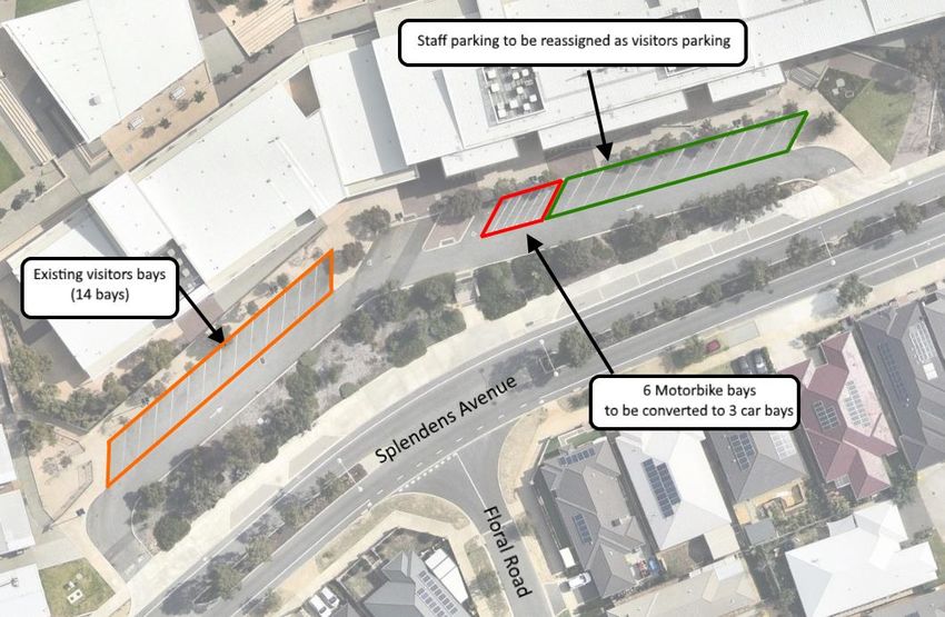
Operational Traffic Management Plan
                                                                                                     Joseph Banks Secondary College Redevelopment

 Contact Information                                                           Document Information

 Cardno (WA) Pty Ltd                                                           Prepared for                        With_ Architecture Studio
 ABN 77 009 119 000
                                                                               Project Name                        Joseph Banks Secondary
                                                                                                                   College Redevelopment
 11 Harvest Terrace
 West Perth WA 6005
                                                                               File Reference                      CW115220-TR-RP-002-
 PO Box 447
                                                                                                                   OTMP.docx

 www.cardno.com                                                                Job Reference                       CW1152200
 Phone +61 8 9273 3888
 Fax         +61 8 9486 8664                                                   Date                                18 March 2021

                                                                               Version Number                      A

 Author(s):

 Raymond Rachmat                                                               Effective Date                      18/03/2021
 Traffic Engineer

 Approved By:

 Ray Cook                                                                      Date Approved                       18/03/2021
 Business Leader – Traffic & Transport Planning

Document History
  Version         Effective Date          Description of Revision                    Prepared by                          Reviewed by

 A                18/03/2021              For Issue                                  RR                                   DH/RJC

© Cardno. Copyright in the whole and every part of this document belongs to Cardno and may not be used, sold, transferred, copied or reproduced in
whole or in part in any manner or form or in or on any media to any person other than by agreement with Cardno.
This document is produced by Cardno solely for the benefit and use by the client in accordance with the terms of the engagement. Cardno does not and
shall not assume any responsibility or liability whatsoever to any third party arising out of any use or reliance by any third party on the content of this
document.

Our report is based on information made available by the client. The validity and comprehensiveness of supplied information has not been independently
verified and, for the purposes of this report, it is assumed that the information provided to Cardno is both complete and accurate. Whilst, to the best of our
knowledge, the information contained in this report is accurate at the date of issue, changes may occur to the site conditions, the site context or the
applicable planning framework. This report should not be used after any such changes without consulting the provider of the report or a suitably qualified
person.

CW1152200 | 18 March 2021 | Commercial in Confidence                                                                                                             ii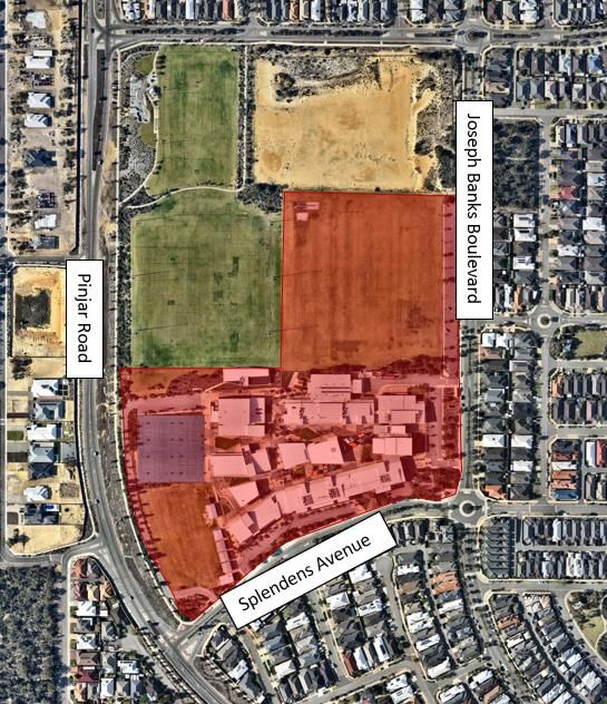
Operational Traffic Management Plan
                                                                      Joseph Banks Secondary College Redevelopment

Table of Contents
       1         Introduction                                                                                     1
       2         Site Context                                                                                     2
                 2.1        Site Location                                                                         2
                 2.2        Existing and Proposed Drop-off / Pick-up Location                                     3
                 2.3        Existing Operational Issues                                                           4
       3         Proposed Access Arrangement and Traffic Management                                               6
                 3.1        Proposed Access Arrangement                                                           6
                 3.2        Proposed Traffic Management Measures                                                  7
       4         Conclusions and Summary                                                                         11

Figures
Figure 2-1    Aerial View of Site Location                                                                        2
Figure 2-2    Existing and Proposed Drop-off / Pick-up Facility Location                                          3
Figure 2-3    Queue from Drop-off / Pick-up Area 1 Spilling into Splendens Avenue                                 4
Figure 2-4    Queue on Splendens Avenue Affecting Pinjar Road                                                     5
Figure 3-1    Access Arrangements                                                                                 6
Figure 3-2    Proposed Left turn pockets                                                                          7
Figure 3-3    Proposed Automatic Drop Cable Gate Locations                                                        8
Figure 3-4    Proposed Area 1 Parking Bays Reallocation                                                           9
Figure 3-5    Internal Access Road Traffic Management                                                            10

CW1152200 | 18 March 2021 | Commercial in Confidence                                                              iii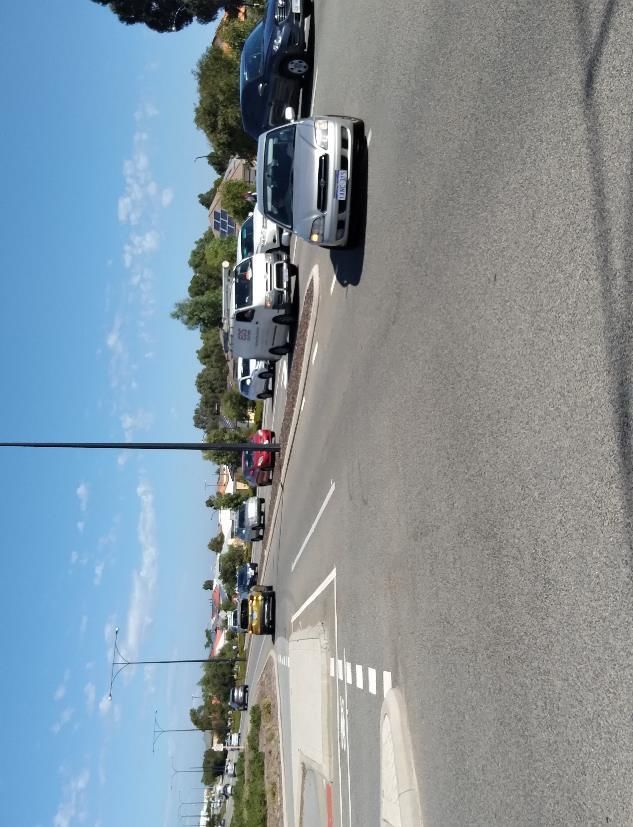
Operational Traffic Management Plan
                                                                    Joseph Banks Secondary College Redevelopment

1         Introduction

Cardno have been commissioned by With_ Architecture Studio on behalf of the Government of Western
Australia, Department of Finance to prepare an Operational Traffic Management Plan as part of the
expansion of the Joseph Banks Secondary College (“the Site”). The Site is located at 40 Joseph Banks
Boulevard, Banksia Grove, within the City of Wanneroo.
It should be noted that this Operational Traffic Management Plan has been prepared under a separate cover
and should be read in conjunction with the Transport Impact Assessment report.
This plan is prepared to address issues of concern raised by the City of Wanneroo traffic engineers related
to the drop-off and pick-up area adjacent to Splendens Avenue, particularly during PM school peak periods
where vehicular queues were observed.

CW1152200 | 18 March 2021 | Commercial in Confidence                                                            1
Operational Traffic Management Plan
                                                                 Joseph Banks Secondary College Redevelopment

2            Site Context

2.1          Site Location
The Site is located in the suburb of Banksia Grove, City of Wanneroo and bounded by Joseph Banks
Boulevard to the east, Splendens Avenue to the south, and Pinjar Road to the west. The proposed
expansion is located on the south west corner of the Site as shown in Figure 2-1.
Figure 2-1     Aerial View of Site Location

                                        Proposed
                                        Expansion

Source: Nearmap (2021)

CW1152200 | 18 March 2021 | Commercial in Confidence                                                         2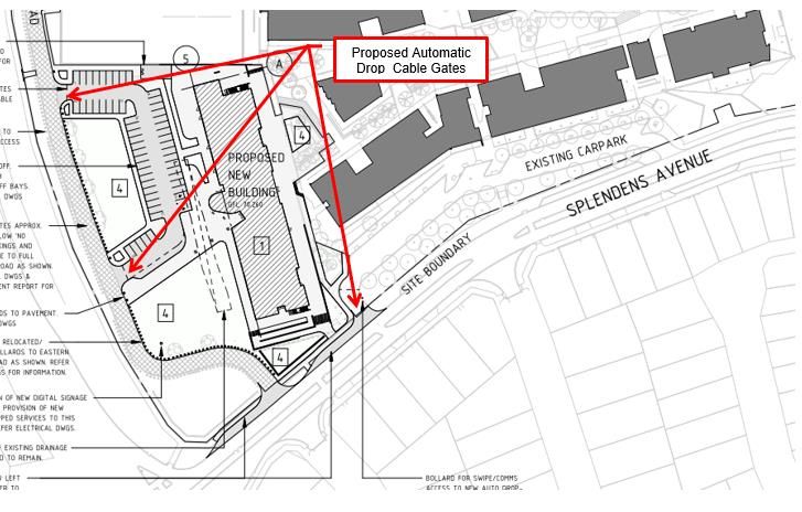
Operational Traffic Management Plan
                                                                            Joseph Banks Secondary College Redevelopment

2.2          Existing and Proposed Drop-off / Pick-up Location
The existing and proposed drop-off / pick-up area locations are shown in Figure 2-2 and listed below:

> Area 1 – an existing facility accessed via Splendens Avenue;
> Area 2 – an existing facility accessed via Joseph Banks Boulevard; and
> Area 3 – a proposed facility accessed via an existing internal access road connected to Splendens
  Avenue.
Figure 2-2     Existing and Proposed Drop-off / Pick-up Facility Location

                                                                                          2

                    3
                                                        1

                                                    Internal
                                                  Access Road

(Source: With_Architecture Studio)

CW1152200 | 18 March 2021 | Commercial in Confidence                                                                    3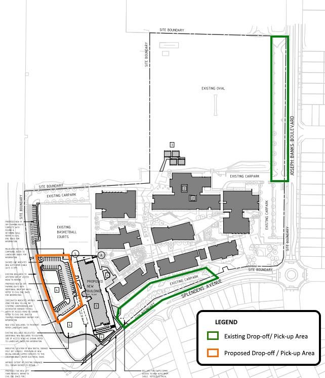
Operational Traffic Management Plan
                                                                                     Joseph Banks Secondary College Redevelopment

2.3          Existing Operational Issues
From site observations undertaken on Tuesday 16 February 2021, the following observations were recorded
during the site visit which was not observed during the initial site visit conducted on Wednesday 2 December
2020:
> Vehicular queues from Area 1 drop-off / pick-up would extend onto Splendens Avenue and all the way to
  the Pinjar Road intersection as shown in Figure 2-3.
> The queue from Area 1 drop-off / pick-up also impacted traffic operations on Pinjar Road, particularly the
  right turn from Pinjar Road southern approach as shown in Figure 2-4. The traffic engineers of the City of
  Wanneroo have raised concerns that the existing vehicular queues would negatively impact the
  accessibility to the future drop-off / pick-up in Area 3 from Splendens Avenue.
> It should be noted that the observed congestion only lasted for approximately 10-15 minutes and traffic
  operations returned to normal thereafter.
Figure 2-3     Queue from Drop-off / Pick-up Area 1 Spilling into Splendens Avenue

CW1152200 | 18 March 2021 | Commercial in Confidence                                                                             4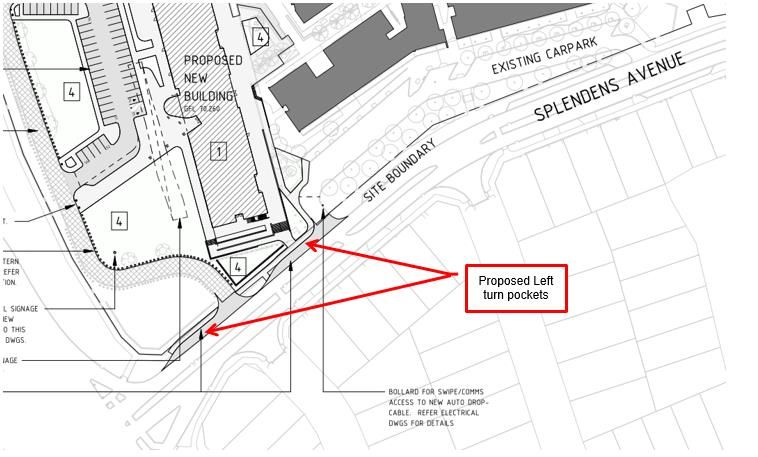
Operational Traffic Management Plan
                                                                       Joseph Banks Secondary College Redevelopment

Figure 2-4    Queue on Splendens Avenue Affecting Pinjar Road

It should be noted that site observations revealed that the drop-off and pick-up activity in Area 2 adjacent to
Joseph Banks Boulevard was far less congested and no significant queuing was observed.

CW1152200 | 18 March 2021 | Commercial in Confidence                                                               5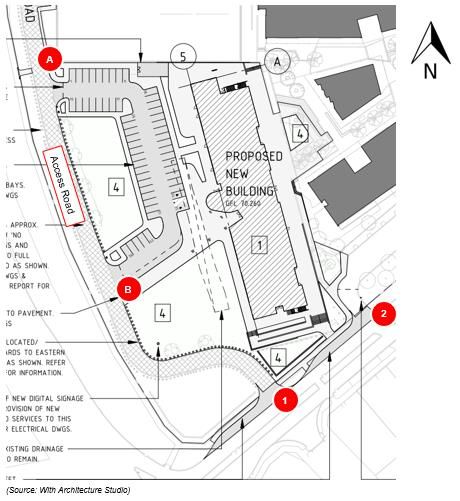
Operational Traffic Management Plan
                                                                      Joseph Banks Secondary College Redevelopment

3            Proposed Access Arrangement and Traffic Management

3.1          Proposed Access Arrangement
Access to the new facilities will be via the internal access road (Access 1) from Splendens Avenue. Figure 3-
1 shows the location of the new facilities and the proposed car park with entry and exit points:
> Access A is entry only (left-in, right in)
> Access B is exit only (left-out, right-out)
The car park will have a one-way clockwise traffic flow circulation which is aimed to provide efficient
movement though the site and ensuring that delays are minimised. The distance from Access A and Access
1 is approximately 160m which would provide additional queuing space if required and as such no queue
overspill is expected onto Splendens Avenue.
Figure 3-1     Access Arrangements

In addition, left turn pockets at the existing Access 1 and 2 as shown in Figure 3-2 will be provided to assist
with traffic operations during school peak hours. This will provide additional storage space on-street to
mitigate against vehicular queues extending onto Splendens Ave and allow for through vehicles to bypass
these queues.

CW1152200 | 18 March 2021 | Commercial in Confidence                                                              6
Operational Traffic Management Plan
                                                                       Joseph Banks Secondary College Redevelopment

Figure 3-2      Proposed Left turn pockets

3.2          Proposed Traffic Management Measures
3.2.1        Allocating Students to Specific Drop-off / Pick-up Area
Based on the site observations, during the PM school pickup periods Area 1 was well utilised resulting in
some congestion being experienced whilst Area 2 was underutilised. Hence, there is potential for drop-off
and pick-up activities to be distributed more evenly between the existing and future drop-off / pick-up areas
to alleviate the congestion currently experienced on Splendens Avenue during the PM school pick up period.
The following is proposed:
> To minimise the existing queues associated with the existing school pick up/drop off area on Splendens
  Avenue, it is recommended that consideration be given to the school pick up/drop off activities being
  distributed proportionately between the existing and new pick up/ drop off areas. The school could
  potentially consider allocating the use of each of the pickup/drop off areas as shown in Figure 2-2 by the
  year of students or by class. Where more than one sibling is attending the same school consideration
  should be given to arranging for either the younger siblings to be collected at the same pickup/drop off
  area as the older sibling or vice versa.
> This traffic management measure must be managed, monitored and modified (where appropriate) by the
  school in order to minimise the queuing on Splendens Avenue.
> Consideration should be given to communicating to parents, students and staff via the school’s website
  and newsletters of the traffic management measures to be implemented.

3.2.2        Staff Parking Management
To ensure that parking in drop-off and pick-up areas are available for use by parents during peak times, it is
proposed that staff park in the existing staff car park adjacent to the administration building and the
gymnasium. It is proposed that automatic drop cable gates be installed at the entry access point of Area 1 as
well as the access points to the proposed new car park (Area 3) to manage the staff parking as shown in
Figure 3-3. It is envisaged that the automatic drop cable gates would be in operation between 8:00AM and
8:30 AM to prevent staff from parking in Area 1 and Area 3 and encourage them to park in the existing car
park adjacent to the administration building and the gymnasium. Parents would be able to use Area 1 and 3
after 8:30 AM and those parents dropping their children before 8:30 would still be able to use Area 2.

CW1152200 | 18 March 2021 | Commercial in Confidence                                                               7
Operational Traffic Management Plan
Joseph Banks Secondary College Redevelopment
Figure 3-3 Proposed Automatic Drop Cable Gate Locations
3.2.3 Increase Visitor Parking Capacity at Area 1
Area 1 currently comprises 12 staff bays and 14 visitor bays, 2 ACROD Bays, 1 sick bay, and 6 motorcycle
bays. It is proposed that the staff parking bays on the on the eastern side of Area 1 be reallocated to visitor
parking and that the 6 motorcycle bays (which are not well used) be converted to 3 car parking bays as
shown in Figure 3-4. Consideration could be given to relocating these motor cycle bays elsewhere on the
site. Total visitor parking bays would be increased to 29 bays with the proposed changes. The ACROD bays
and the sick bay are to remain and are not proposed to be reassigned.
CW1152200 | 18 March 2021 | Commercial in Confidence 8Operational Traffic Management Plan
Joseph Banks Secondary College Redevelopment
Figure 3-4 Proposed Area 1 Parking Bays Reallocation
Based on the site visit observations, it is estimated that approximately 80 vehicles entered Area 1 during the
PM school peak period (the busiest period). This estimate includes cars arriving prior to pick up at 3PM and
parked in Area 1 as well as vehicles arriving after 3PM. Assuming a 5 minutes dwell time for each bay, within
a 15-minute period (i.e. the duration which the pick-up activity occurred), each bay would have a turnover
rate of 3. Hence it is estimated that the proposed 29 visitor bays in Area 1 would be able to accommodate
about 87 cars in the busiest 15-minute period during the PM school peak.
It is anticipated that the increase in visitor parking supply in Area 1 would be able to cater for the existing
parking demand although it is recommended that allocating students to be picked up and dropped off at
allocated areas should still be considered. It should be noted that the new trips and pick up and drop off
operations associated with the proposed school expansion would be accommodated in the new car park in
Area 3.
Consideration should also be given to communicating to parents, students and staff via the school’s website
and newsletters of the traffic management measures to be implemented in Area 1.
CW1152200 | 18 March 2021 | Commercial in Confidence 9Operational Traffic Management Plan
Joseph Banks Secondary College Redevelopment
3.2.4 Internal Access Road Traffic Management
To ensure efficient traffic movement to and from the new car park (Area 3), the following traffic management
measures are proposed as illustrated in the site plan shown in Figure 3-5.
> Bollards on the eastern side of the Access Road are recommended to be relocated closer to the edge of
the existing Access Road to discourage parking on the verge which potentially could impact traffic
operations.
> Yellow ‘No stopping’ edge line marking and corresponding signage along the length of the Access Road
Figure 3-5 Internal Access Road Traffic Management
(Source: With_Architect Studio)
CW1152200 | 18 March 2021 | Commercial in Confidence 10Operational Traffic Management Plan
Joseph Banks Secondary College Redevelopment
4 Conclusions and Summary
This Operational Traffic Management Plan proposes measures to be implemented to mitigate against the
existing traffic issues related to the drop-off and pick-up area adjacent to Splendens Avenue, particularly
during PM school peak periods. This matter was raised by the City of Wanneroo, as a concern which could
impact the proposed expansion of Joseph Banks Secondary College (“the Site”) located in Banksia Grove,
City of Wanneroo.
The traffic management solutions identified comprises the following:
> Allocating students to specific pick up and drop off areas within the school Site;
> Managing the staff parking and proposing that staff park in the existing staff car park adjacent to the
administration building and the gymnasium;
> Increasing visitor parking in the existing pick up and drop off area adjacent to Splendens Avenue (Area 1)
by reallocating the staff parking bays on the eastern side to visitor parking and converting the 6
motorcycle bays to 3 car parking bays; and
> Implementing line marking and signage as well as moving existing bollards closer to the edge of the
existing Access Road to discourage parking on the verge which potentially could impact traffic operations.
The above Traffic Management measures are considered to be appropriate and anticipated to be suitably
adequate to address the concerns of the City of Wanneroo and improve the traffic operations at the Joseph
Banks Secondary College.
CW1152200 | 18 March 2021 | Commercial in Confidence 11Operational Traffic Management Plan
Joseph Banks Secondary College Redevelopment
About Cardno
Cardno is a professional infrastructure and
environmental services company, with expertise in
the development and improvement of physical and
social infrastructure for communities around the
world. Cardno’s team includes leading professionals
who plan, design, manage and deliver sustainable
projects and community programs. Cardno is an
international company listed on the Australian
Securities Exchange [ASX:CDD].
Contact
11 Harvest Terrace
West Perth WA 6005
PO Box 447
Phone +61 8 9273 3888
Fax +61 8 9486 8664
Web Address
www.cardno.com
CW1152200 | 18 March 2021 | Commercial in Confidence 12You can also read