PALAEOLITHIC RESEARCH FRAMEWORK FOR THE BRISTOL AVON BASIN WENBAN-SMITH
←
→
Page content transcription
If your browser does not render page correctly, please read the page content below
PALAEOLITHIC RESEARCH FRAMEWORK
    FOR THE BRISTOL AVON BASIN
     M R BATES & F F WENBAN-SMITH

                                    March 2005
PALAEOLITHIC RESEARCH FRAMEWORK FOR THE
           BRISTOL AVON BASIN

                   MR Bates

                  Brynawelon,
                  Ciliau Aeron,
                   Lampeter,
                   Ceredigion,
                     Wales.
                   SA48 7SE

                  01570-471015
              bullybates@fsmail.net

                       &

               FF Wenban-Smith

            Department of Archaeology
            University of Southampton
                  Southampton
                    SO17 1BJ

                  07771-623 096
                ffws@soton.ac.uk

                  March 2005
CONTENTS

SUMMARY

Acknowledgements

1 INTRODUCTION
   1.1 Project background
   1.2 The Pleistocene
   1.3 The Palaeolithic

2 STUDY REGION — THE BRISTOL AVON BASIN

3 PLEISTOCENE GEOLOGY
   3.1 Overview
   3.2 Headwaters, north of Malmesbury
   3.3 Upper Avon, from Malmesbury to Bradford-on-Avon
   3.4 Upper Middle Avon, Bradford-on-Avon to Bathampton
   3.5 Bathampton– Keynsham (entrance of Hanham Gorge)
   3.6 Bristol, Keynsham to Clifton
   3.7 Shirehampton, Clifton to Severn
   3.8 Severn, Avonmouth–Weston-in-Gordano
   3.9 High level gravels of the Avon system

4 PALAEOLITHIC ARCHAEOLOGY
   4.1 Overview
    4.1.1 Sources and quantification
    4.1.2 Distribution and depositional context
    4.1.3 Period and cultural tradition
    4.1.4 Raw material
   4.2 Headwaters, north of Malmesbury
   4.3 Upper Avon, from Malmesbury to Bradford-on-Avon
   4.4 Upper Middle Avon, Bradford-on-Avon to Bathampton
   4.5 Bathampton– Keynsham (entrance of Hanham Gorge)
   4.6 Bristol, Keynsham to Clifton
   4.7 Shirehampton, Clifton to Severn
   4.8 Severn, Avonmouth– Portishead

5 RESEARCH FRAMEWORK
   5.1 National Palaeolithic research framework
    5.1.1 Research themes and priorities
    5.1.2 The resource
   5.2 Palaeolithic research priorities in the Bristol Avon basin
    5.2.1 Key regional themes and priorities (R)
    5.2.2 Landscape zone objectives
5.3 Strategic projects
 5.4 Dissemination, education and community involvement

6 DEVELOPMENT CONTROL: A STRATEGY FOR THE PALAEOLITHIC
RESOURCE
   6.1 Development control and Palaeolithic archaeology
   6.2 The Palaeolithic resource
    6.2.1 Pleistocene deposits
    6.2.2 Palaeolithic remains and relevant information
    6.2.3 Disturbance and integrity
   6.3 Proposals for action
    6.3.1 Strategy
    6.3.2 Curatorial awareness
    6.3.3 Baseline resource characterisation
    6.3.4 Desk-based assessment
    6.3.5 Evaluation
    6.3.6 Mitigation
    6.3.7 Complementary projects

TABLES

 Table 1. Quaternary epochs and the Marine Isotope Stage framework.
 Table 2. Palaeolithic period in Britain.
 Table 3. Identified Pleistocene deposits in the Bristol Region
 Table 4. Stratigraphical correlation of deposits in the Bristol region
 Table 5. Key Pleistocene sites in the study area
 Table 6. Palaeolithic finds by river stretch and depositional context.
 Table 7. Bristol region key research themes/priorities.
 Table 8. Landscape zone research objectives.
 Table 9. Classes of Pleistocene deposit.
 Table 10. Palaeolithic remains and relevant information.
 Table 11. English Heritage criteria for Palaeolithic importance adapted from
            English Heritage, 1991; English Heritage/Prehistoric Society, 1999).

FIGURES

 Figure 1. Site location plan showing main sites discussed in text.
 Figure 2. Reconstructed palaeogeography in the West Midlands and the Marches
            prior to the Anglian glaciation (based on Maddy 1997).
 Figure 3. A: Horsecombe Vale transect showing main sediment units. B: detailed
            cross section of Pit 1 containing late glacial molluscs. Based on
            Chandler et al. 1976.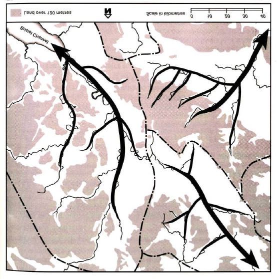
Figure 4. Main sites discussed in text within the Bath region.
Figure 5. Section at Victoria Pit, Twerton, Bath, 1948 (from Chandler et al. 1976).
Figure 6. Main sites discussed in text within the Shirehampton/Chapel Pill area.
Red dotted line shows the approximate location of transverse section
shown in Figure 5A.
Figure 7. A: transverse section of Avon Terrace 2 at Shirehampton (the 100-foot
terrace) (from ApSimon and Boon, 1959). 1: Portway A4; 2: Burnham
Road; 3: Walton Road and Allotments; 4: Shirehampton Burial
Ground; 5: High Street and West Camp Site. Stipples: stratified fluvial
sediments; triangles: Head; ORS: Old Red Sandstone; LST: Limestone
Shales; Trias: Keuper Marl etc. B: West Camp, Shirehampton sketch
section from manhole cutting (ApSimon and Boon, 1959). C:
Palaeolithic implements from the Shirehampton area (Lacaille, 1954).
1: Cleaver made on chert from Grove Leaze; 2: chert handaxe from
Station Road; 3: chert handaxe in heavily rolled condition.
Figure 8. Palaeolithic artefacts from Chapel Pill Farm, Abbots Leigh (after
Lacaille, 1954). 1: Triangular handaxe of brown sandstone; 2: chert
handaxe; 3: ovate handaxe made of sandstone; 4 and 5 rolled flint
flakes; 6: rolled chert flake.
Figure 9. A collection of Palaeolithic artefacts from Chapel Pill Farm, Abbots
Leigh (after Lacaille, 1954). 1-4, 6: flakes; 5 and 7: blades; 8 and 9:
cores; 10: handaxe; 11-13: compound tools.
Figure 10. Distribution of borehole records held in British Geological Survey
GeoIndex for the area of Bath town centre and environs.
Figure 11. Distribution of borehole records held in British Geological Survey
GeoIndex for the Shirehampton area.
PLATES
Plate 1. General view of Bath urban area.
Plate 2. Unmapped terrace surface downstream of Bath.
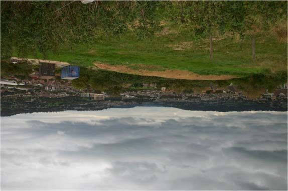
Plate 3. Former Somerset and Dorset Railway cutting (now a linear park) at
Twerton. This cutting exposed gravels containing animal bones.
Plate 4. Possible former quarry site at Larkhall, Bath (now a municipal park).
Plate 5. Chapel Pill Farm area and south side of Avon.
Plate 6. View towards Clifton Gorge showing area of Terrace 2 deposits on south
side of Avon at Chapel Pill Farm.
Plate 7. Excavations at Twyford House, Shirehampton into Terrace 2 deposits.
Note shoring method and access to sequences at base of trench.
Plate 8. Detailed view of sediments beneath Terrace 2 in Shirehampton showing
basal gravelly sands overlain by mollusc rich sands and, towards the top,
cold climate solifluction deposits.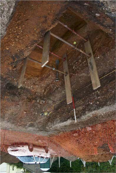
APPENDICES

1. PALAEOLITHIC SITES IN THE BRISTOL AVON BASIN

2. PROFORMA METHOD STATEMENT FOR PALAEOLITHIC/
PLEISTOCENE FIELD EVALUATION

3. RECORDING OF PLEISTOCENE SEDIMENTS

4. PALAEOLITHIC ARTEFACT RECOGNITION AND TYPOLOGY
SUMMARY

This document was commissioned by the City Archaeologist, Bristol City
Council to review the Palaeolithic archaeological potential of the Bristol Avon
region. This report describes the main features of both the Palaeolithic
archaeological resource for the region and the Pleistocene record that
contextualises this resource.

Key points to emerge from the review are:

Pleistocene geology

  - Surviving Pleistocene deposits are unevenly distributed throughout the
    system

  - Deposits in two areas — around Bath and Shirehampton — are already
    proven to contain significant archaeological and biological remains. Other
    areas, not yet identified, are also likely to contain similar evidence

  - Faunal remains are relatively common in the Bath region but are also
    known from other areas such as Shirehampton and Sutton Benger

  - Dating is poorly understood but most deposits probably date to different
    parts of the Middle Pleistocene, between 500,000 and 125,000 BP,
    corresponding with the Lower and Middle Palaeolithic

  - Additional work remains to be undertaken to determine the precise
    number of fluvial aggradations and terraces

  - Slope deposits and Head are also present and may include buried
    landsurfaces of Late Pleistocene age, corresponding with the late Middle
    and Upper Palaeolithic

Palaeolithic archaeology

  - Artefacts exhibit considerable variation in the raw material used in tool
    production, with significant use of non-flint lithologies

  - One major finds ‘hot spot’ has been identified in Terrace 2 gravels at
    Shirehampton, representing intensive activity in the Lower/Middle
    Palaeolithic

  - Finds from other areas — such as Kelston and above the Hanham Gorge —
    also indicate the presence of Lower/Middle Palaeolithic activity in other
    parts of the region. Further investigation of surviving deposits across the
    region is likely to produce more widespread evidence for Palaeolithic
    activity, even where no remains have yet been found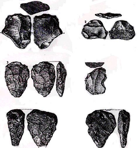
- There is a predominance of handaxes in the collections, but flake-tool and
    Levallois technology are present where more extensive collections exist
    from certain locations, particularly Shirehampton

  - There is a curious absence of artefacts from the Bath area despite the
    major degree of investigation of the fossil and other biological remains in
    the Pleistocene deposits of the area; it remains to be demonstrated whether
    this is a real feature of the record or a case of collecting bias

  - None of the sites from which Palaeolithic material has come is well dated

While present knowledge is restricted due to limited previous investigations, the
Palaeolithic and fossil remains that have been found demonstrate that
considerable potential exists for Palaeolithic study in the Bristol Avon region.
Besides potential for developing an improved understanding of the regional
Palaeolithic record, there is also potential to contribute to addressing a number
of key national research objectives, as outlined by English Heritage in Exploring
our Past (1991) and in the more recent national Palaeolithic Research
Framework (English Heritage/Prehistoric Society 1999).
A framework is outlined by which the Palaeolithic potential of the region can be
investigated through mitigation of any impacts caused by development,
supported by description of suitable methods of investigation, and the relation of
any mitigating works to national/regional research objectives. A number of
suggestions are also made for specific projects that could be carried out to
develop understanding of the overall Palaeolithic/Pleistocene chronological and
stratigraphic framework in the region, to provide a baseline characterisation of
the resource and a context for the Palaeolithic remains already known, and yet to
be discovered, from the region.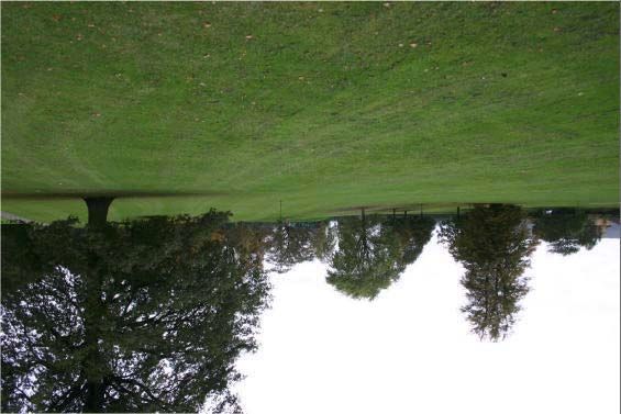
Acknowledgements

The authors would like to thank Bristol City Council for funding the research and in
particular staff in the Archaeology section for help when putting the document
together. The comments of Gail Boyle, Curator of Prehistoric and Roman
Archaeology, Bristol Museum and Art Gallery and David Evans, Historic
Environment Officer, South Gloucestershire Council on the draft of the document are
gratefully acknowledged.

All photographs and illustrations are by the authors except where otherwise credited.

© M. R. Bates and F. F. Wenban-Smith, 2005
The right of M. R. Bates and F. F. Wenban-Smith to be identified as the Authors of this work has been
asserted by them in accordance with the Copyrights, Designs and Patents Act 1988. The Authors have
granted a licence to Bristol City Council and their agents to use and reproduce the material contained
within.

The Ordnance Survey maps within this document are reproduced with the permission of Ordnance
Survey on behalf of the Controller of Her Majesty’s Stationery Office © Crown copyright.
Unauthorised reproduction infringes Crown copyright and may lead to prosecution or civil
proceedings. Bristol City Council 100023406, 2005.
1. INTRODUCTION

1.1 Project background
This project was commissioned by the Bristol City Archaeologist in July 2004. The
impetus for the study was initiated by work in the Shirehampton district of Bristol in
2003 when a site of potential Palaeolithic importance was investigated by the Avon
Archaeological Unit. During the course of investigation Terra Nova Ltd. was called
upon to provide specialist services to the archaeological unit in Palaeolithic
archaeology and Pleistocene geology and environments. Despite the absence of
sequences of Palaeolithic or Pleistocene significance a report was prepared on the
Palaeolithic archaeological potential of the region (Bates, 2003). This report
highlights some of the key issues relating to the Palaeolithic archaeology of the area
and draws attention to the relatively poorly understood sequences and lack of recent
investigation in the region.
Following consideration of the report and its distribution via the Bristol City Council
web pages (www.bristol-city.gov.uk/archaeology) a meeting was held in November
2003 to progress work and understanding of the Palaeolithic resources in the wider
Avon region. An outcome of this meeting was the desire to provide additional
information on the Palaeolithic and Pleistocene potential of the river system in the
Bath/Bristol region. This report provides that detailed overview.

1.2 The Pleistocene
The initial Palaeolithic occupation and subsequent settlement of Britain has taken
place against the backdrop of the Quaternary period, characterised by the onset and
recurrence of a series of alternating cold–warm/glacial–interglacial climatic cycles
(Lowe and Walker 1997). Over 60 cycles have been identified during the last 1.8
million years, corresponding with fluctuations in proportions of the Oxygen isotopes
O16 and O18 in deep-sea sediment sequences. These marine isotope stages (MIS) have
been numbered by counting back from the present-day interglacial or Holocene period
(MI Stage 1), with (usually) interglacials having odd numbers and glacials even
numbers, and dated by a combination of radiometric dating and tuning to the
astronomical timescale of orbital variations, which have been a fundamental causative
agent of the Quaternary climatic fluctuations. The Quaternary is divided into two
epochs – the Holocene and the Pleistocene – where the Holocene represents the
present-day interglacial and the Pleistocene represents the remainder of the
Quaternary that is divided into Early, Middle and Late parts (Table 1). The Middle
and Late Pleistocene are of most relevance to British Palaeolithic archaeology, with
the first occupation of Britain occurring circa 700,000 BP in the Middle Pleistocene,
and continuing thereafter, albeit with occasional gaps.
Middle and Late Pleistocene climatic oscillations were sufficiently marked to have a
major impact on sea level and terrestrial sedimentation regimes. In the colder periods
ice sheets grew across much of the country, and arboreal forests disappeared, to be
replaced by steppe or tundra. Sea levels dropped across the globe due to the amount of
water locked up as ice, exposing wide areas offshore as dry land, and enhancing river
channel downcutting. In the warmer periods sea levels rose as ice melted, river
channels tended to be stable and prone to silting up and the development of alluvial
floodplains (Gibbard and Lewin 2002), and forests regenerated. The range of faunal
species inhabiting Britain changed in association with these climatic and
environmental changes, with both evolution of species in situ to adapt to these
changes and local extinction/ recolonisation of species in response to changing
environmental conditions.
Britain has been particularly sensitive to these changes, being i) situated at a latitude
that has allowed the growth of ice sheets in cold periods and the development of
temperate forests in warm periods, and ii) periodically isolated as an island by rising
sea levels and then rejoined to the continent when sea level falls (White and Shreeve
2000). This has led to different climatic stages having reasonably distinctive sets of
associated fauna and flora. These both reflect in general terms the climate and
environment, and may also identify in specific terms the MI Stage represented. The
study of such evidence — such as large mammals, small vertebrates, molluscs,
ostracods, insects and pollen — is an integral part of Pleistocene, and Palaeolithic,
research for its role in dating early hominid occupation and recreating the associated
palaeo-environment.
The evidence from different MI Stages is contained in terrestrial deposits formed
during the stage. In contrast to the deep-sea bed, where there has been continuous
sedimentation, terrestrial deposition only occurs in specific, limited parts of the
landscape. It is also takes place as a series of short-lived depositional events such as
land-slips or river-floods interrupted by long periods of stability and erosion. Thus the
terrestrial record is relatively piecemeal, and the challenge for both Pleistocene and
Palaeolithic investigation is to integrate the terrestrial evidence into the global MIS
framework, based on relatively few direct stratigraphic relationships, and making
maximum use of biological evidence and inferences about the sequence of deposition
in major systems such as river valleys (Bridgland et al. 2004).
Present understanding is summarised in Table 1. The current interglacial began circa
10,000 BP (years before present) and it is generally agreed that MI Stages 2–5d,
dating from circa 10,000–115,000 BP cover the last glaciation (Devensian), and that
Stage 5e, dating from circa 115,000–125,000 BP, correlates with the short-lived peak
warmth of the last interglacial (Ipswichian). Beyond that disagreement increases,
although many British workers feel confident in accepting that MI Stage 12, which
ended abruptly circa 425,000 BP, correlates with the major British Anglian glaciation
when ice-sheets reached as far south as the northern outskirts of London (Bridgland
1994).
It is also important to remember that the MI Stage framework only reflects major
climatic trends. Within each MI Stage there were also numerous climatic oscillations,
represented by maybe only a few centimetres within sediment cores 10–20 metres
long, that have not been recognised as distinct numbered stages. These still potentially
correspond to a few thousand years of climatic change, with potential for associated
changes in environment and sedimentary deposition. Some of the larger diversions
have been recognised as distinct sub-stages with the MIS framework (such as Stage
5e), but many have not, and their presence has the potential to confound overly
simplistic correlations of isolated terrestrial sequences with peaks or troughs on the
continuous marine record. Colder diversions within predominantly warm stages are
known as stadials, and warmer diversions within cold stages as interstadials.

1.3 The Palaeolithic
The Palaeolithic covers the time span from the initial colonisation of Britain in the
Middle Pleistocene, possibly as long ago as 700,000 years ago (Wymer 2003), to the
end of the Late Pleistocene, corresponding with the end of the last ice age circa 10,000
years ago. Thus the Palaeolithic period occupies almost 700,000 years, and includes at
least eight major glacial–interglacial cycles (Table 1), accompanied by dramatic
changes in climate, landscape and environmental resources. At the cold peak of glacial
periods, ice-sheets 100s of metres thick would have covered most of Britain, reaching
on occasion as far south as London, and the country must have been uninhabitable. At
the warm peak of interglacials, mollusc species that now inhabit the Nile were abundant
in British rivers, and fauna such as hippopotamus and forest elephant were common in
the landscape. For the majority of the time, however, the climate would have been
somewhere between these extremes.
After the formation of the Channel probably some time in the later Middle Pleistocene
(Gibbard 1995) human access to Britain was only possible during periods of cold
climate when sea levels were lower and consequently early hominids were only
periodically present in Britain (White and Schreeve 2000), which was at the northern
margin of the inhabited world. The archaeological evidence of the period mostly
comprises flint tools, and the waste flakes left from their manufacture. These are very
robust and resistant to decay, and, once made and discarded, persist in the landscape,
eventually becoming buried or transported by sedimentary processes related to climatic
change and landscape evolution. Other forms of evidence include faunal dietary
remains of large animals, sometimes cut-marked reflecting the stripping of flesh for
food or broken open for marrow extraction and, very rarely, wooden artefacts. These
forms of evidence are, however, more vulnerable to decay, and it is only very rarely that
burial conditions were suitable for their preservation through to the present day.
Hominid skeletal remains have also been found on occasion although, again, these are
very rare and require exceptional conditions for their preservation.
The British Palaeolithic has been divided into three broad, chronologically successive
stages — Lower, Middle and Upper — based primarily on changing types of stone
tool (Table 2). This framework was developed in the 19th century, before any
knowledge of the types of human ancestor associated with the evidence of each
period, and without much knowledge of the timescale. This tripartite division has
nonetheless broadly stood the test of time, proving both to reflect a general
chronological succession across Britain and northwest Europe, and to correspond with
the evolution of different ancestral human species.
Evidence of very early occupation of Britain has recently been discovered on the
Norfolk coast at Pakefield (Wymer 2003), dating to possibly as old as MIS 17, circa
700,000 BP. The evidence consists of very simple cores and flakes, and was
presumably made by a form of Homo erectus/ergaster, known to be present in
Central/Eastern Europe from over 1,000,000 BP. Following this, at present, isolated
occurrence of very early hominid presence, there are a number of sites dating from MIS
13, circa 500,000 BP associated with the later western European Homo heidelbergensis,
particularly at Boxgrove in Sussex, where an extensive area of undisturbed evidence is
associated with abundant faunal remains and palaeo-environmental indicators (Roberts
and Parfitt 1999). It is worth noting here that the impact of the Anglian glacial advance
in MI Stage 12 has had considerable impact on the geographical structure of the
landscape associated with these early hominid sites in Britain. Major re-modelling of
the major drainage basins such as the Thames (Gibbard 1985) and the creation of the
Severn and Fen basins (Rose, 1994) have resulted in the destruction of much of the
landscape associated with the earliest phases of human activity (Wymer 2001) while
elsewhere, e.g. central East Anglia, the evidence remains deeply buried by the till
deposits associated with the Anglian ice advance (e.g. Lewis 1998).
From the Anglian onwards Palaeolithic occupation becomes more frequent in Britain,
although probably not continuous. There was gradual evolution of an Archaic hominid
lineage from Homo heidelbergensis into Neanderthals (Homo neanderthalensis) during
the period from 500,000 BP up to the middle of the last glaciation (circa 35,000 BP).
Very broadly speaking, the Lower Palaeolithic is associated with early Archaics and
handaxe manufacture (Acheulian), and the Middle Palaeolithic with the development of
Neanderthals and increasingly sophisticated flake-tool based lithic technology
(Levalloisian and Mousterian), alongside one distinctive form of handaxe, the bout
coupé. It has, however, become clear with improved dating of several key sites, as
well as the recent discovery of the Pakefield site, that the definition and distinction of
Lower and Middle Palaeolithic are less clear-cut than was originally thought.
The Lower Palaeolithic embraces a variety of lithic technologies besides handaxe
manufacture. At Pakefield, there is not a hint of handaxe manufacture, and the lithic
industry consists entirely of small flint cores and flakes. Following this, most early
sites are dominated by the manufacture of handaxes, although usually alongside a
small component of core/flake production. However, there are also a number of
contemporary early sites without handaxe manufacture that can be included as Lower
Palaeolithic — particularly the manifestations of crude cores, flakes and notched
flake-tools that occur at several sites in Kent and East Anglia and are labelled as
Clactonian. It is also uncertain to what extent the manufacture of handaxes persisted
alongside the uptake of “Middle Palaeolithic” Levalloisian and Mousterian
technology, whether different human groups were involved, and whether a transition
from Lower to Middle Palaeolithic took place contemporaneously across the whole of
Britain. Handaxes are scarce, but present, at most of the few Levalloisian sites known
in Britain. These may be derived from earlier deposits, or contemporary with the
Levalloisian material. The problem is that our understanding of the Lower and Middle
Palaeolithic archaeological record is restricted by:

   - Poor provenance of most finds

   - Difficulty of dating deposits of this age

   - Uncertainties over the extent of earlier derived material in assemblages

After 35,000 BP, Neanderthals were suddenly replaced in Britain and northwest Europe
by anatomically modern humans (Homo sapiens sapiens), who are associated with the
later, Upper part of the Palaeolithic. The Upper Palaeolithic is also characterised by
cultural changes such as the development of bone and antler tools and the representation
of images of animals painted on cave walls or as small antler or bone carvings. The
suddenness of this change and the physiological differences between Neanderthals and
modern humans, as well as recent DNA studies, suggest that modern humans did not
evolve from Neanderthals, but evolved elsewhere, probably in Africa or western Asia
circa 125,000 BP, before colonising other parts of the world.
In contrast to the Lower and Middle Palaeolithic periods, the relatively recent age of the
Upper Palaeolithic, and the fact that, at least in Britain, the period is within the range of
radiocarbon dating, means that our understanding of the period is good. It is clear that,
at least in Britain, there is a well-defined and clear break between the Middle and the
Upper Palaeolithic. Upper Palaeolithic evidence is very sparse in Britain. The climate
was in the second half of a major glacial episode, and human presence was probably
limited to occasional parties venturing to the edge of their habitable range. Some
material has been recovered from deposits accumulated in cave sites on the Welsh
coast, in Devon, in Herefordshire and in the Peak District dating to the milder climatic
phase before the Last Glacial Maximum of circa 20,000–15,000 BP (Barton and
Collcutt 1986).
There was no human presence in Britain during the Last Glacial Maximum, and
recolonisation did not take place until a short phase of climatic amelioration
(Windermere Interstadial) from circa 13,000 to 12,000 BP towards the end of the last
ice age. Again, the majority of the evidence comes from cave deposits. This short-lived
episode of Upper Palaeolithic settlement/recolonisation, characterised by a blade-based
technology with distinctive backed points — Creswell, Cheddar and Penknife points —
was brought to an end by a renewed climatic deterioration (Loch Lomond re-advance),
marking the final stage of the last glaciation. After this climate improved at the onset of
the Holocene, and Britain was recolonised again, by people with a characteristic Long
Blade technology, which rapidly developed into Mesolithic.

2 STUDY REGION: THE BRISTOL AVON BASIN

The river Avon (Figure 1) drains parts of Gloucestershire, Wiltshire and Somerset as
well as the City and County of Bristol. Today the river rises on the dip slope of the
Middle Jurassic limestone in the southern Cotswolds near Chipping Sodbury. The
river then runs east and subsequently south through Wiltshire before turning through
Bradford-on-Avon. Upstream of Bath Pleistocene sediments have been noted to
occur as a series of remnants of fluvial sediments resting on either side of the river
where the river is excavated into the Jurassic sediments between Bradford-on-Avon
and Malmesbury. From Bath the river follows a generally north west trending route
across Lower Jurassic rocks to a gorge at Hanham that has been cut into Pennant
sandstone (Kellaway and Welch 1993). The river subsequently flows westwards
across the soft, low lying Triassic rocks in central Bristol before entering a second
gorge at Clifton that is cut into the Carboniferous Limestone. Today the river is
confluent with the Severn at Avonmouth and is tidal as far as St. Anne’s.
The influence of the two major gorges at Hanham and Clifton has a considerable
impact on the operation of the river and effectively divides the river into a series of
river stretches (Table 3) where floodplains exist on either side of the river separated
by reaches of the river within the gorges that have no floodplain associated with the
river. The presence of the gorges makes correlation between individual sectors of the
river difficult if not impossible without independent means of correlation.

3 PLEISTOCENE GEOLOGY

3.1 Overview
The river Avon has been shown to contain a rich variety of sites containing
Pleistocene sediments some of which contain faunal, floral and archaeological
remains (Davies and Fry 1929; Lacaille 1954, Wessex Archaeology 1994; Campbell
et al. 1998).
The Pleistocene development of the Avon system is considered to have its origin as a
superimposed river developed on a former Triassic age landscape (Barton et al. 2002).
During the Pleistocene lowered sea levels probably resulted in the stripping of much
of the Triassic cover to reveal the underlying Carboniferous limestone. Local
glaciation at the western end of the system occurred during the (?)Middle Pleistocene
(Kellaway and Welch 1993; Campbell et al. 1998) when glacial deposits consisting of
poorly sorted sand and gravel were deposited in the vicinity of Clevedon.
Fluvial sediments, deposited by the Avon during the Pleistocene, are well known
between Bathampton and the coast and previous authors to work in the area include
Oriel (1904), Davies and Fry (1929), Palmer (1931), Lacaille (1954), Chandler et al.
(1976) and Kellaway and Welch (1993). The most recent overview of the nature of
the sequences have been produced by Campbell et al. (1999) who considered the
distribution of the sediments associated with the river and identified three distinct
members within the Avon Valley Formation (Table 3). This tripartite system has
been applied to the entire valley system despite the difficulties encountered in tracing
deposits between different sections of the valley through the gorges at Clifton and
Hanham. The three-fold subdivision of sequences can also be traced in the work of
other authors such as Davies and Fry (1929) and the British Geological Survey
(1965). Furthermore Davies and Fry (1929) indicate that fluvial gravels also rest on
the plateau surfaces adjacent to the main valley.
Unfortunately because of the presence of the deep gorges at Clifton and Hanham it is
impossible to trace these deposits as continuous spreads along the course of the river.
Consequently correlation of the sediments is difficult. Kellaway and Welch (1993),
following Chandler et al. (1976), suggest that the three groups of sediments may be
broadly correlated with the Ipswichian, Middle Devensian and Late Devensian
periods. However, this scheme is difficult to equate with the deposits of the Severn
(Maddy 1999). Furthermore the acceptance of such as scheme would not easily fit the
models currently accepted to be responsible for fluvial sand and gravel aggradation
and terracing (e.g. as considered by Bridgland 1996, 2000; Maddy 1997). It should
however be noted that the presence of 2 bedrock gorge sections are likely to impact on
such conventional models.
The most recently published information on the area (Campbell et al., 1998, 1999)
would indicate that the sediments lying between the mouth of the Avon and
Bathampton can all be accommodated within the Avon Formation (Campbell et al.
1999) (Tables 3 and 4). This consists of fluvial gravels and other related sediments
that have been grouped into a series of morphological terraces with three individual
members identified as the:

   1. Ham Green Member. The stratotype for this member is at Ham Green (ST
      539768) where 3-4 metres of gravel with a surface elevation about 30 metres
      above the present valley base (Hunt 1998a). These deposits are compared
      with those known to have contained large mammal remains in the basal
      gravels at the Victoria Pit, Twerton (Winwood 1889; Davies and Fry 1929) as
      well as sands containing interglacial or interstadial mollusc from beneath
      gravels in the railway cutting at Twerton (Winwood 1875). Campbell et al
      (1999) suggest correlation with MIS 12.

   2. Stidham Member. The stratotype of this Member is at Stidham Farm, Saltford
      (ST 674 684) where the gravels comprise 2 metres of trough cross-bedded
      gravels with a coarse basal lag containing animal bones including mammoth
      (Moore, 1870, Woodward 1876, Davies and Fry 1929; Hunt 1998b). The
      surface of the gravels lie at about 12 metres above the modern river. A
      possible correlation of MIS 8 is suggested by Campbell et al (1999).
3. Bathampton Member. The stratotype for this Member is at Hampton Rocks
Railway cutting (ST 778 667) where up to 3 metres of trough cross-bedded
gravels are noted to contain a cold stage mollusc fauna (Weston 1850,
Woodward 1876; Hunt 1998c). The gravels are overlain by an interglacial soil
and coversands (Hunt 1990). The sediments lie about 3 metres above the
modern floodplain. The presence of the interglacial soil indicates a minimum
age of MIS 6 for the underlying gravels of the Bathampton Member.
The weakness of this tripartite sequence is that it does not take into consideration the
influence of the gorges and the difficulties of correlating between different sectors of
the river as separated by the gorges. Consequently it is felt that the stratigraphy and
age of the gravels of the Avon are at present poorly understood. All authors would
agree that the sediments ascribed to the Avon Formation all post-date the major
glaciation of the area (perhaps occurring during MIS 16, Campbell et al. 1998, 1999)
but despite attempts to date the sediments no clear inferences can presently be made.
Most significantly because of urban sprawl many of the supposedly rich fossil sites
are no longer visible and recent observations have been restricted to key views in
pipe/foundation trenches, cemeteries etc. Because of these difficulties and the major
palaeogeographical changes associated with glaciation of the Midlands during MIS 12
it is very difficult to reconstruct the local palaeogeographies of the region and the
relationship between the Avon drainage patterns and those of the ancestral Thames
and Severn rivers (Figure 2) (see Maddy 1997 for discussion).
Elsewhere within the Bristol region other types of sediments exist that are likely to
correlate with the sequences associated with the fluvial deposits. For example
marine/estuarine sediments have been described at Kennpier (Gilbertson and Hawkins
1978; Hunt 1981; Hunt 1998d), Kenn Church (Gilbertson and Hawkins 1978; Hunt
1998e) and Weston-in- Gordano (ApSimon and Donovan 1956; Hunt 1998f) while
terrestrial and freshwater deposits occur at Yew Tree Farm (Gilbertson and Hawkins
1978; Hunt 1981, 1998g). Currently the age of these deposits remains somewhat
problematic and they are difficult to relate to the fluvial deposits.
As a consequence of the study a number of key sites of importance to the
understanding of the Pleistocene geology and landscape evolution have been
identified within the study region. These are summarised in Table 5.
3.2 Headwaters, north of Malmesbury
Little evidence exists within the region of Malmesbury for fluvial deposition in the
headwaters of the Avon system. This is unsurprising as fluvial deposition, terrace
formation and the preservation of such deposits are unlikely high within the
headwaters of a major drainage basin. Cave (1977) has reported on the Pleistocene
sediments of the area but little useful information pertains to issues directed towards
the Palaeolithic resource of the area.
Davies and Fry (1929) note that a number of sections exhibited fine limestone gravels
around Brokenborough and on the Sherston Road about a mile west of Malmesbury.
Here the gravel was nearly 4 feet thick and caps low tracts of rising ground above the
river.3.3 Upper Avon, from Malmesbury to Bradford-on-Avon At least two distinct terraces exist in this stretch of the Avon. The associated deposits are extensive, relatively well-mapped and overlie impermeable Oxford Clay bedrock. Most extensively preserved are deposits associated with Terrace 1 that form extensive spreads around Melksham, Chippenham and Sutton Benger. Terrace 2 shows a considerably reduced distribution but occurs around Melksham. The presence of the clay bedrock may be of significance when considering the preservation potential of the sediments as the impermeable nature of the clay should enhance likelihood of preservation of floral remains. Faunal remains are already known to be present in Terrace 1 at the Pyramid Pit, Sutton Benger while a fossil skull of an ox was noted to have been found by Henry Woods in 1839 (Davies and Fry 1929). Occasional spreads of material classified by the BGS alluvial cone material (e.g. at Middle Lodge Farm, NGR ST 93000 71000). In part these deposits appear to rest on the surface of the Terrace 1 deposits and are consequently likely to post-date the deposition of this terrace in certain locations. However, it remains possible that the core of these fans may be considerably older than the margins of the fans and consequently pre-date Terrace 1. 3.4 Upper Middle Avon, Bradford-on-Avon to Bathampton Hardly any Pleistocene deposits have been mapped in this area. There is a small patch of T1 gravel at the southern end of the stretch, and a couple of patches of Head gravel (which may nonetheless overlie fluvial terrace remnants) at several places beside the river course, for instance under the Roman Villa at Holcombe. The majority of the valley flanks are covered by undifferentiated landslip deposits, which may mask more extensive Pleistocene fluvial deposits. For example at Freshford solifluction deposits have been found overlying a thin gravel body Moore 1870; Woodward 1876; Winwood 1889a) that contained a fauna with Elephas primigenius tusk and teeth, Rhinoceros tichorinus, Equus caballus, Bison europoeus, Cervus tarandus and Ovibos moschatus. It is likely that the landslip deposits are complex and as yet poorly understood however, Chandler et al. (1976) have considered the patterns of landslips in the Bath area within the Jurassic strata and were able to demonstrate that some slides occurred during the late Pleistocene (e.g. at Horsecombe Vale, NGR ST 75300 62000) where late glacial molluscs were located in association with buried soils in the head deposits (Figure 3). Elsewhere they argue that landslides may have occurred earlier in the Devensian. The evidence presented by Chandler et al. clearly suggests that a number of different types of material exists in association with the landslips and illustrate this at Horsecombe Vale (Figure 3) where both a basal limestone head and an overlying clay-rich head occurs. 3.5 Bathampton– Keynsham (entrance of Hanham Gorge) This is one of the most important reaches of the river system for the preservation of sequences of Pleistocene sediments (Plate 1). Typically three terraces have been mapped within the area by the British Geological Survey (1965). The main sites are illustrated in Figure 4. Although a number of important sites occur within the region (Table 5) the distribution of mapped terraces and sediments is relatively restricted (BGS, 1965) with narrow ribbons of Terrace 1 and 2 restricted to patches along the valley margins
and occasional patches of higher elevation material ascribed to Terrace 3, e.g. at
Twerton. Elsewhere clear morphological terraces (Plate 2).
The highest patches of terrace gravel within the area occur at Twerton in the old
Victoria Gravel quarry where deposits lie at approximately 45 metres O.D. (27 metres
above the modern alluvium) (Winwood 1889b; Palmer 1931) (Figure 5). The deposits
present consist of some 3 metres of horizontally bedded gravels overlain by clay and
sand beds below head (Chandler et al. 1976). The faunal assemblage consists of
Mammuthus primigenius (Mammoth), Palaeoloxodon antiquus (straight-tusked
elephant), Equus caballus (horse), Coelodonta antiquitatis (Woolly rhinoceros), Sus
scrofa (pig), Cervus elephas (red deer) and Bision priscus (bison) (Palmer 1931).
This fauna is indicative of cool, perhaps late interglacial, conditions. Similar deposits
including fauna and molluscs were also recorded from Terrace 3 at the nearby
Moorfield cutting (Winwood 1875) (Plate 3). According to Campbell et al (1999)
these deposits may be ascribed to MIS 12.
Terrace 2 has also produced faunal remains at Hampton Rock (Hunt 1998d), Newton
St. Loe (Owen 1846; Dawkins 1866; Moore 1870; Woodward 1876; Winwood 1889;
Hunt 1998b), Lambridge (Woodward 1876; Winwood 1889a), the Bellott Road Pit,
Twerton (Palmer 1931) and at Larkhall (Moore 1870; Winwood 1889a; Palmer 1931).
At Larkhall (Plate 4) molluscs as well as the remains of Elephas primigenius
(Mammuthus primigenius), Elephas antiquus tusk and teeth, Rhinoceros tichorinus,
reindeer, bison and horse have also been found. Campbell et al (1999) have
suggested a possible correlation with MIS 8 for these deposits.
Terrace 1 has been investigated at Hampton Rocks Railway cutting (ST 778 667)
where up to 3 metres of trough cross-bedded gravels are noted to contain a cold stage
mollusc fauna (Weston 1850, Woodward 1876; Hunt 1998c). The gravels are
overlain by an interglacial soil and coversands (Hunt 1990). The sediments lie about
3 metres above the modern floodplain. Here the presence of the interglacial soil
indicates a minimum age of MIS 6 for the underlying gravels of the Bathampton
Member.
Elsewhere faunal material has been reported from the vicinity of the Royal Crescent
(Woodward 1876) where there appears to be no evidence for the presence of
Pleistocene deposits according to the BGS map.

3.6 Bristol, Keynsham to Clifton
The plateau above Hanham Gorge contains thin spreads of gravel that are currently
mapped as soliflucted Head gravels, but which were originally mapped as fluvial
terrace remnants, relating to courses of the Avon prior to downcutting into the
Hanham Gorge. Given the thinness of the gravel bodies, and their angular and clay-
rich nature (Fry 1955, 124) it is likely that these gravel bodies are mostly the
soliflucted remnants of fluvial deposits, although undisturbed fluvial deposits may be
preserved in isolated pockets under the Head deposits. Although these spreads occur
over a wide height range and probably relate to more than one original terrace, the
subsequent derivation of material means that surface finds cannot now be reliably
attributed to a particular terrace.
Fluvial sediments associated with terraces within the Bristol basin area are rare.
Occasional patches mapped as Terrace 1 are present (e.g. 359400 172350) whilst
more extensive areas of Terrace 1 are mapped in a tributary valley extending south
west towards Long Ashton and Cambridge Batch.
Occasional patches of head gravel are also present above Clifton gorge on the south
side of the river.
At present the age of any of these deposits cannot be determined.

3.7 Shirehampton, Clifton to Severn
This sector of the river (Plates 5 and 6) preserves sediments ascribed to both Terraces
1 and 2 (Figure 6). Extensive spreads of Terrace 2 exist at Shirehampton, Chapel Pill
Farm and Ham Green while Terrace 1 occurs on the lower slopes at Shirehampton.
Head deposits occur at the mouth of the Avon where it enters the floodplain of the
Severn. Although not known for the presence of faunal material in recent years one
of the earliest published references to the Pleistocene sequences of the area report the
discovery of large molars of an elephant in the diluvial gravel (Rutter 1829).
Unfortunately the location and context of discovery of these finds are unknown.
Known as an area rich in handaxe finds the description of sequences in the area are
often linked to these Palaeolithic discoveries. For example at Shirehampton Lacaille
(1954) describes sediments beneath Terrace 2 (with surface elevations of circa 30
metres O.D.) consisting of bedded sands and gravels up to 10 feet thick. On the south
bank he recorded similar sequences at Chapel Pill Farm. Some of the observations
from the Shirehampton area were assembled into a cross section through the Terrace
and the underlying sediments by ApSimon and Boon (1959) and their illustration is
presented here (Figure 7).
Recent archaeological investigations at the Health Centre (ST 53100 76900) revealed
the presence of bedded gravels below solifluction deposits (Wessex Archaeology
2004). Most recently (October 2004) an archaeological evaluation conducted by the
Avon Archaeological Unit at the site of Twyford House has revealed a sequences of
bedded sands and gravels beneath solifluction deposits containing molluscan remains
(Plates 7 and 8).
Campbell et al (1999) suggest correlation of the Terrace 2 deposits with MIS 12
although this is based on correlations made with Terrace 3 upstream at Twerton.

3.8 Severn, Avonmouth–Weston-in-Gordano
The oldest deposits within this region are sands and gravels preserved in a depression
or channel at Court Hill (NGR ST 43650 72250) that are of probable glacial origin
(Kellaway and Welch 1993; Hunt 1998h). Another sequence of probable glacial
sediments are located at Portishead Down (NGR ST 45000 75100), however, the
difference in gravel content between these two sequences suggest that they belong to
different phases of glaciation.
Terrace 1 deposits are mapped extensively around Sheepway and Portbury. Davies
and Fry (1929) note that while sections through these deposits are rare 4 foot of gravel
has been noted during cable laying between 1927 and 1929 in the area. Terrace 1
deposits at Sheepway were noted by Fry (1955) to consist of a thin covering of sandy
loam containing chert, flint and quartzite pebbles. Hawkins (1968) draws attention to
the fact that these gravels appear to occupy similar elevations to those discovered at
Weston-in- Gordano (see below). Two sub-alluvium gravel bodies at different
elevations are also noted by Hawkins (1968) suggesting a more complex sequence of
events are recorded in the downstream elements of the Avon.
An important sequence of marine and terrestrial deposits were discovered by
ApSimon and Donovan (1956) at Weston-in- Gordano where a sequence of deposits
consisting of sand and gravels beneath head deposits were noted. Hunt (1998i) has
demonstrated that the sediments contain molluscs as well as pollen and the faunal
remains indicate a marine to terrestrial trend in the deposits. Hunt (1998i) ascribes
these deposits to MIS 7. Raised beach deposits (of the 50-foot beach) have been
noted (Palmer 1931) just below the Pier Hotel.

3.9 High level gravels of the Avon system
High level gravels have been reported from some areas of the Avon catchment,
particularly around Bathampton Down and Kingsdown and some authors (Oriel 1904;
Hawkins and Kellaway 1971) have ascribed these deposits to an early stage of fluvial
history. Other examples are provided by Davies and Fry (1929).

4 PALAEOLITHIC ARCHAEOLOGY

4.1 Overview

4.1.1 Sources and quantification
This review of the Palaeolithic of the region is based on a synthesis of published
material, primarily the Southern Rivers Project survey (Wessex Archaeology 1994)
supported by Sites and Monuments Record data for the Bristol region and a number of
other papers (Davies and Fry 1929; Lacaille 1954; Fry 1955; Brown 1956; Roe 1974).
In total 39 sites are known in the Bristol Avon region with Lower/Middle Palaeolithic
finds, which include almost 300 handaxes. The region has been divided for this
review into seven stretches, from the headwaters northwest of Malmesbury to the
river mouth at Portishead (Section 3). Finds from each stretch are discussed below,
and summarised by depositional context (Table 6).
Present understanding of the Palaeolithic in the region is based on handaxe finds. The
majority of sites comprise handaxe find-spots, although other types of lithic artefact
have also been collected and attributed to the Palaeolithic when found alongside
handaxes. Handaxes are quite distinct and can reliably be attributed to the
Lower/Middle Palaeolithic, whereas flakes and cores are more ambiguous as to
period. Almost all finds have been recovered from the surface of ploughed fields, and
so any flakes, cores and flake-tools could also have come from later prehistoric
periods, such as Mesolithic, Neolithic or Bronze Age. Thus other manifestations of
the Palaeolithic such as flake-tools and flake/core technologies, such as Clactonian,
Mousterian and Levalloisian remain relatively invisible, if ever present.

4.1.2 Distribution and depositional context
Finds are scarce in the middle and upper parts of the Avon, from Bristol eastward,
despite extensive tracts of Pleistocene fluvial terrace deposits in places. Finds are,
however, abundant in patches of terrace gravel on both banks of the river at
Shirehampton to the west of Bristol. Finds are also present in small patches of gravel
west of Shirehampton and on Portishead Down, although the date and origin of these
deposits is still uncertain.
The majority of finds are from fluvial terrace deposits of sand and gravel, or from
colluvial/ solifluction deposits mapped as Head. These latter in many cases most likely
include material derived from terrace deposits, and also may overlie unrecognised
remnants of terrace deposit. There are also a number of finds not related to mapped
Pleistocene deposits, generally from high ground above the river valley. These are
probably from residual deposits of plateau or high terrace gravel that are too small to
feature on geological mapping, although they may alternatively have been imported to
where they were found by later human action — the two handaxe finds at Solsbury
Hill may be related to the hillfort that tops the hill, and it has been suggested that the
handaxe find at Hilperton (Stretch 2, Upper Avon) may have been a collector’s throw-
out.
The great majority of material in the survey (90%) comes from Terrace 2 sites at
Shirehampton, and in particular Chapel Pill Farm. This probably reflects increased
collecting activity in the area, and increased examination of exposures created by
building work. It is probable that the apparent absence of finds in other parts of the
region is due to a relative lack of investigation, and a systematic investigation of
exposures of deposits in the Middle and Upper Avon stretches would produce
substantial quantities of material.
Another relevant factor may be the use of a variety of non-flint raw materials for
Palaeolithic artefacts (Section 4.1.4). Artefacts made of materials such as sandstone,
quartzite and chert would (a) be less easily found in gravel deposits than flint
artefacts, (b) be less easily distinguished from natural gravel due to being more
rapidly abraded during incorporation in fluvial gravels and (c) probably not have been
sought by collectors. Subsequent research in the region should pay particular attention
to identifying the range of non-flint raw materials potentially usable for stone tools,
considering the likely impact of Pleistocene depositional processes upon these
materials and seeking artefacts made of them (Section 5.3).

4.1.3 Period and cultural tradition
As has been discussed in Section 3, nowhere along the Avon has a formation of more
than three terraces been identified within any particular stretch of the river. In fact
only two separate terraces have been identified along most stretches, although there
are hints of higher level unmapped deposits in places. Due to the peculiarities of the
Avon basin, with a series of constricting gorges separating different stretches of the
river, a more extended terrace sequence, such as in the Thames Valley, has not
developed. This means (a) that individual terraces may regularly have been reworked
without the usual downcutting, and may contain channelling of different periods and
(b) that it is problematic correlating terraces between different river stretches.
Palaeolithic remains are present in Terrace 2 in the Shirehampton stretch, and in
Terrace 1 in the Upper Avon, Shirehampton and Severn stretches. Due to the above-
mentioned problems, we presently have little clear idea of how old these terrace
deposits are however, it is likely that they date to the later parts of the Middle
Pleistocene (Table 4). Many of the finds on which present knowledge is based are,
however, in fresh condition, indicating a minimal history of derivation and that they
are probably contemporary with the deposit in which they are found. It is likely that
they are no older than the Anglian glaciation (MI Stage 12), since small patches of
glacial till in the region indicate local glaciation at some point, which would have
scoured away previous terrace remnants, and must have been either the Anglian or a
subsequent glaciation, since maximum ice-sheet expansion took place in the Anglian.
Other Palaeolithic find-spots have occurred in high-level residual or plateau gravel
contexts, or Head deposits, about which we have even less idea of date than for the
terrace deposits. Overall, finding some means of dating and correlating the
Pleistocene deposits along different stretches of the Avon (and also in its major
tributaries such as the Frome and Biss) is a priority for Palaeolithic archaeology of the
region (Sections 5.2 and 5.3).
As mentioned above, present understanding of the Palaeolithic of the region is very
much based on the recovery of handaxes. These are typically present in the Lower and
Middle Palaeolithic of Britain, from the pre-Anglian interglacial (MIS 13, circa
500,000 BP) through to at least MIS 7, circa 200,000 BP. The prevalence and
recovery of handaxes from at least some locations indicates presence in the region in
this broad period. Unfortunately it is not possible to use the shape of the handaxes to
pin down more precisely the date and period of occupation. It is clear from other
studies that handaxe-shape is very varied through the Palaeolithic, and as yet we do
not have any clear-cut rules relating shape to period, bar the exclusive presence of
assemblages dominated by flat-butted, rounded tip bout coupé forms in the later
Devensian, in MIS 3, circa 65,000–40,000 BP.
There is a great variety of handaxe forms and sizes in the material from the Avon
region. Based on published material, the most common form seems to be sub-cordates
of medium size, with a blunt point formed by quite convex sides, and with a thick
partially worked butt. A number of smaller forms are more triangular than this, with a
sharper point and unworked butt. A number are also more cordate, with a more fully
worked butt. There seem to be no, or very few, true ovates. Generally, the handaxes
that have been found in the region to-date are not as large or finely made as many
from the more prolific regions of south-east England such as the Thames Valley,
Solent Basin and East Anglia. This does not necessarily indicate a contrast in lithic
industrial traditions. Raw material could have been an important factor in this
expressed typological variation, since few handaxes from the region are made of flint.
Most are made of chert, and other materials used include indurated sandstone and
quartzite (Section 4.1.4).
It is not possible to say without a more detailed study whether there is any patterning
in handaxe shape in the region, possibly related to terrace level, raw material or river
stretch. Carrying out an investigation of this, to characterise the resource in more
detail would be a useful part of developing a coherent Palaeolithic research
framework for the Avon region (Section 5.3).
There is very little information on non- handaxe material. Artefacts other than
handaxes cannot reliably be attributed to the Palaeolithic when found as surface finds,
which are the basis of our present understanding. A few apparently-worked flakes
have been found from several sites, and interpreted as flake-tools. However, for such
material, it is hard to distinguish deliberate working from post-depositional abrasion
and most of these may well be merely abraded waste debitage. Uniquely, the
collections from Chapel Pill Farm, on Terrace 2 of the Avon at Shirehampton, include
substantial quantities of cores and flakes (Lacaille 1954, 18). These are mostly
technologically undiagnostic, and may have come from either early stages of handaxe
reduction or non- handaxe simple flake/core reduction, which is often carried out
alongside handaxe manufacture.
There is, however, also a convincing manifestation of Levalloisian prepared core
technique in the material from Chapel Pill Farm. Several cores seem to have been
deliberately shaped to facilitate removal of a single large flake from one face, and
there are also several complementary flakes in the collection, showing signs of radial
working and core preparation on their dorsal surface. Similar material is also present
in the collection from the Cemetery site in the same terrace at Shirehampton, but on
the opposite side of the river. Levalloisian material is only reported from these two
sites. This is, however, the most intensely collected location in the Avon region.
Similar levels of collecting at other locations in the region might produce a greater
variety of material than the ubiquitous handaxe. Levalloisian technology first appears
in England early in the Middle Palaeolithic, probably late in MIS 8 circa 250,000 BP
although there may be some earlier manifestations, and does not appear to have been
used at the few bout coupé sites that are dated to after the peak last interglacial (MIS
5e, circa 125,000 BP). Therefore the Levalloisian evidence in the Bristol region
probably reflects early Neanderthal occupation in the period MIS 8 to MIS 6. No bout
coupé handaxe finds are known from the region, but the finds from Wales (Coygan
Cave), Wiltshire (Fisherton), Somerset (Cheddon Fitzpaine, Pitminster and West
Quantoxhead) and Dorset (Bournemouth and Sherbourne) suggest that there was a
late Neanderthal population in southwestern England in the later Devensian.
Only two Upper Palaeolithic find-spots are present in the study region, both surface
finds in the South Gloucestershire region. One of them (SMR ref. 4522) is a
trapezoidally retouched blade segment from Bury Hillfort, Winterbourne (NGR ST
652 791). The recovery of other later prehistoric lithic material including a stone
mace-head from the surface of the site casts some doubt as to whether this is truly an
Upper Palaeolithic piece, or whether of later prehistoric date. The other (SMR ref.
4767) is a backed blade from Freezing Hill, Cold Ashton (NGR ST 721 715), from
high ground on the northern side of the Bathampton–Keynsham stretch of the Avon.
This is slightly more convincing, although not definitive, evidence of occupation in
the region in the Upper Palaeolithic. Despite this lack of evidence, the quantity of
Upper Palaeolithic remains from nearby areas such as Wales (Gower Caves),
Herefordshire (Wye Valley) and Devon (Torquay and Torbryan Valley) indicates that
there would have been Upper Palaeolithic presence in the Bristol Avon region. This is
most likely to be preserved in cave or rockshelter sites, if any can be found in the
Bristol Avon or its tributaries. There may also be occasional open-air situations where
unusual circumstances have led to the deposition and burial of Upper Palaeolithic
material, possibly within alluvial floodplains.

4.1.4 Raw material
Only a few of the finds from the region are made of flint. The majority of finds are
made of pale brown or golden (“honey-coloured”) chert. Other materials reported
include indurated sandstone and quartzite. Those made of flint would have stood out
from the chert-rich gravels that predominate in the region, making them easier to spot
and recover. Although flint is present in Pleistocene deposits in the region, the nearest
outcrop of fresh nodular flint from Chalk is at Westbury, at the southeast edge of the
Avon Basin. The majority of flint raw material in deposits along the route of the Avon
Valley would have been derived as the product of fluvial, solifluction or glacial
transport. Thus flint raw material would have been scarce, degraded by frost action
and rolling, and pieces of size and quality suitable for handaxe manufacture would
have been rare.
Little work has been done investigating the range of non-flint raw materials suitable
for lithic manufacture, and the restrictions the nature of these materials might impose
on refinement and typological form. Artefacts made of at least three other materials
— chert, sandstone and quartzite — are reported in the literature (see especially
Lacaille 1954, 12–13). Given the varied geological bedrock of the Avon basin, it is
possible that a considerable number of lithological types might be potentially usable
You can also read