PARTICIPATORY COASTAL SPATIAL PLANNING FOR TIEN LANG DISTRICT - TENURE AND GLOBAL CLIMATE CHANGE (TGCC) PROGRAM
←
→
Page content transcription
If your browser does not render page correctly, please read the page content below
PARTICIPATORY COASTAL SPATIAL
PLANNING FOR TIEN LANG
DISTRICT
TENURE AND GLOBAL CLIMATE CHANGE (TGCC) PROGRAM

                                                  TGCC/VIETNAM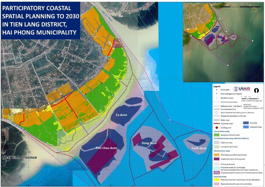
This publication was produced for review by the United States Agency for International Development by
Tetra Tech, through the Tenure and Global Climate Change Project, Contract No: AID-OAA-TO-13-
00016.
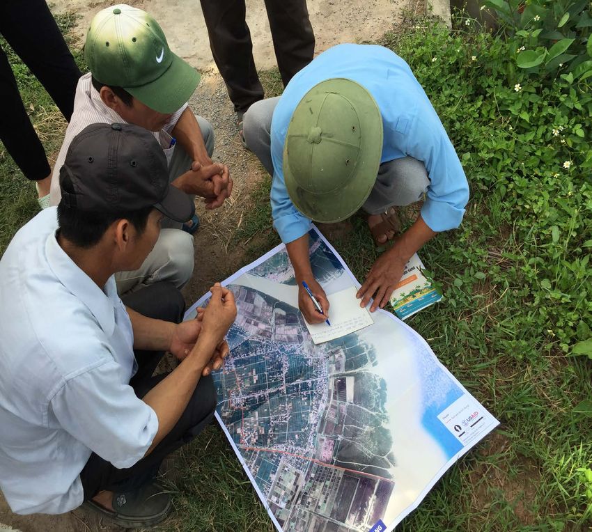
Cover Photo: Coastal resources user groups make notes on district map.
Report Authors: Dr. Nguyễn Chu Hồi, Dr. Cao Lệ Quyên, and Nguyễn Ngọc Hân
Suggested Citation: Nguyễn Chu Hồi, Cao Lệ Quyên, & Nguyễn Ngọc Hân. (2017). Participatory
coastal spatial planning in Tien Lang district. Washington, DC: USAID Tenure and
Global Climate Change Program.
Prepared by: Tetra Tech
159 Bank Street, Suite 300
Burlington, VT 05401
Principal Contacts: Matt Sommerville, Chief of Party
Matt.Sommerville@tetratech.com
Cristina Alvarez, Project Manager
Cristina.Alvarez@tetratech.com
Megan Huth, Deputy Project Manager
Megan.Huth@tetratech.com
PARTICIPATORY COASTAL
SPATIAL PLANNING IN TIEN
LANG DISTRICT
TENURE AND GLOBAL CLIMATE CHANGE (TGCC)
PROGRAM

JANUARY 2018

DISCLAIMER

This report is made possible by the generous support of the American people through the United
States Agency for International Development (USAID). The contents of this report are the sole
responsibility of its authors and do not necessarily reflect the views of USAID or the United States
government.
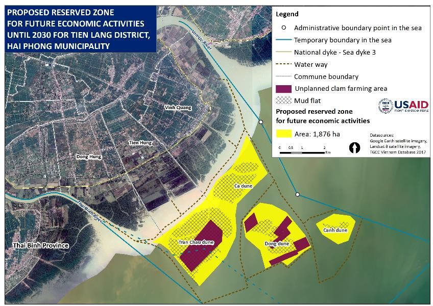
TABLE OF CONTENTS
TABLE OF CONTENTS ................................................................................................................................ i
ACRONYMS AND ABBREVIATIONS ........................................................................................................ ii
1.0      INTRODUCTION ................................................................................................................................ 3
2.0      BACKGROUND ................................................................................................................................... 4
   2.1                  OBJECTIVES AND SCOPE OF THE PLANNING ..................................................................................................... 4
   2.2                  LEGAL BASELINE ................................................................................................................................................... 4
   2.3                  APPROACHES AND STUDY METHODS ................................................................................................................ 4
3.0      ASSESSMENT OF EXISTING CONDITIONS ................................................................................. 6
   3.1                  COASTAL RESOURCE STATUS AND USE ............................................................................................................ 6
   3.2                  CONFLICTS AND OVERLAPS IN RESOURCE USE AND PROPOSED SOLUTIONS ............................................... 9
   3.3                  REVIEW OF PLANS IN RELEVANT SECTORS ...................................................................................................... 11
   3.4                  IMPACTS OF CLIMATE CHANGE ON COASTAL AREAS OF TIEN LANG DISTRICT......................................... 13
4.0      DEVELOPMENT OF COASTAL SPATIAL PLANNING SCENARIOS FOR TIEN LANG
         DISTRICT ........................................................................................................................................... 14
   4.1                  DEVELOPMENT OF PLANNING VISIONS............................................................................................................ 14
   4.2                  DEVELOPMENT OF PLANNING TARGETS.......................................................................................................... 15
   4.3                  COASTAL SPATIAL ZONING SCENARIOS ......................................................................................................... 15
5.0      DEVELOPMENT OF A SPATIAL MANAGEMENT PLAN FOR TIEN LANG COASTAL
         AREAS ................................................................................................................................................. 23
6.0      CONCLUSIONS AND RECOMMENDATIONS ............................................................................ 26
ANNEX A: RELEVANT LEGISLATION ................................................................................................... 28

                                                    PARTICIPATORY COASTAL SPATIAL PLANNING IN TIEN LANG DISTRICT                                                                           i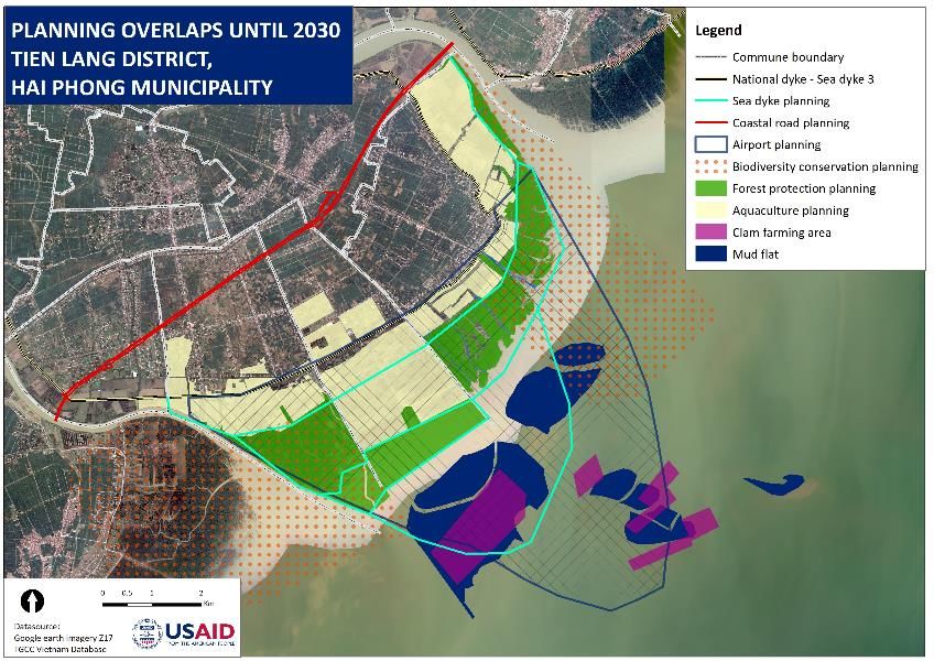
ACRONYMS AND
ABBREVIATIONS
CPC       Commune People’s Committee
DoA       Department of Agriculture
DoF       Department of Fisheries
DPC       District People’s Committee
MARD      Ministry of Agriculture and Rural Development
MONRE     Ministry of Natural Resources and Environment
MPC       Municipal People’s Committee
PCRA      Participatory Coastal Resource Assessment
TGCC      Tenure and Global Climate Change Program
USAID     United States Agency for International Development

ii      PARTICIPATORY COASTAL SPATIAL PLANNING IN TIEN LANG DISTRICT
1.0 INTRODUCTION
The coastal plain and mud flat tidal area of Tien Lang district in Hai Phong municipality has three coastal
communes: Vinh Quang, Tien Hung, and Đong Hung. The area is situated between the mouths of the
Van Uc and Thai Binh rivers. This coastal area has been created by sediment accumulation from both
rivers and possesses mangroves and a rich diversity of aquatic resources. The area plays a very
important role in local socioeconomic development and in maintaining local livelihoods.
The coastal area includes land both inside and outside the sea-dike with mangroves covering the mud
flats. The area borders the Gulf of Tonkin to the east, Thai Binh river to the south, and Van Uc river in
the north. The coastal landscape has multiple uses, including gleaning, traditional fishing by hand and by
small boat, aquaculture pond farming, clam farming, and mangrove protection and management. Some of
these economic activities are part of the Hai Phong municipal development planning area.
Historically, local communities, who are the key coastal resources users, have not been involved in the
coastal spatial planning. Given that coastal resources in general and mangroves in particular are under a
range of development pressures, there is a clear need to pilot a coastal spatial planning approach that
integrates local knowledge and local decision-making into the management of the coastline. In particular,
there are a range of conflicts regarding resource use, productivity (through pollution and poor resource
management), and benefit-sharing that a cross-sectoral, participatory, and ecosystem-based coastal
planning process can help to resolve.
The United State Agency for International Development (USAID)-funded Tenure and Global Climate
Change (TGCC) Program implemented a pilot project called, Our Coast – Our Future, to support the
identification of effective approaches to participatory coastal spatial planning and mangrove co-
management in the Red River Delta. The pilot was carried out in collaboration with the Ministry of
Agriculture and Rural Development (MARD), which has authority over Vietnam’s mangroves areas. The
pilot project supports the implementation of Decree 119/2016/ND-CP that provides policies on
sustainable management, protection, and development of coastal forests for adapting to climate change.
A five-step process, shown in the figure below, was developed and tested under this pilot.
    Figure 1: The Five-Step Process for Participatory Coastal Spatial Planning and Mangrove Co-
                                Management in Tien Lang District

Over the period October 2016 to December 2017, the project team worked in collaboration with the
municipal, district, and commune administration, as well as local communities within Tien Lang district’s
three coastal communes, in carrying out the process. This report covers the process and results of
steps one through four; the fifth step was a separate activity.

                                PARTICIPATORY COASTAL SPATIAL PLANNING IN TIEN LANG DISTRICT                  3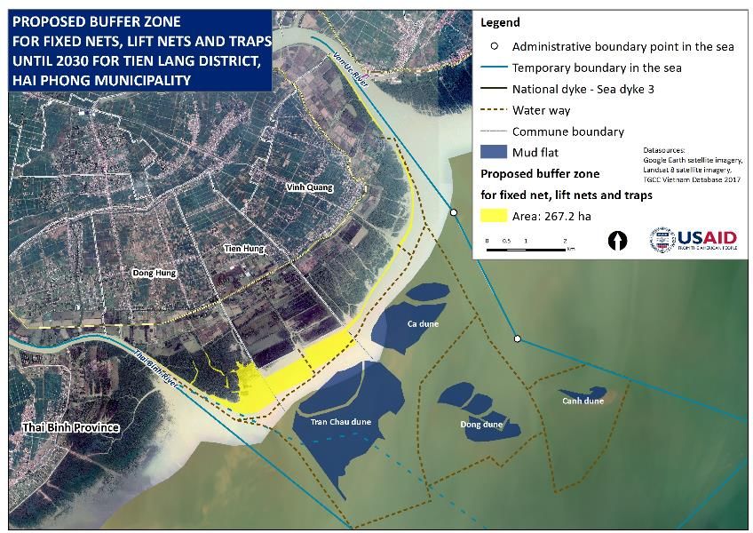
2.0 BACKGROUND
2.1     OBJECTIVES AND SCOPE OF THE PLANNING
The objectives of the activity were to: (1) understand the status of coastal resources and their use; (2)
identify conflicts and overlapping uses; (3) assess how the relevant legislation and sectoral plans, as well
as climate change scenarios, affect the type of future spatial scenarios that are feasible; (4) develop
alternative spatial scenarios; and (5) select one scenario for which to create a spatial implementation
plan.
The planning process was scoped across both time and geography. The temporal scope was through
2030 with road maps covering 2018 to 2020, 2021 to 2025, and 2026 to 2030. The geographic scope
was the coastal space of the three communes (Vinh Quang, Tien Hung, and Đong Hung) of Tien Lang
district, area from sea-dike to coastal waters appointed for Tien Lang district to manage following
Decision No.1478/QĐ-UBND dated 12/06/2017 of Hai Phong Municipal People’s Committee (MPC) on
implementation of temporary sea frontier delimitation for administrative management. Total planned
spatial area is some 9,844 hectares.

2.2     LEGAL BASELINE
Legislation which could influence the type of spatial scenario that can be developed in Tien Lang was
reviewed and summarized for local stakeholders. A list of the relevant legislation is in Annex A.

2.3     APPROACHES AND STUDY METHODS
The coastal spatial planning and associated management plan produced for the three coastal communes
and for Tien Lang district were developed through a participatory approach with the active participation
of local communities and commune authorities, as well as district line agencies. Methods used included:
    •   Collection and analysis of secondary source data. This included existing data from scientific
        publications, study results, development plans, and plans related to coastal areas, the state of
        coastal resources and environment, and climate change sea rise level scenarios;
    •   Participatory coastal resource assessment (PCRA). The PCRA aimed to add local data and
        information identified after a gap analysis of the secondary source data. Government and
        community counterparts carried out surveys and collected information on coastal uses.
    •   Participatory development of coastal resource use planning and management plan. Workshops were
        held in each coastal commune to attract participation of local communities and officials. The
        initial workshops aimed to develop the planning scenarios, with subsequent workshops focused
        on development of the management plan. Next, an inter-commune workshop combined the
        scenarios and management plan from each commune to develop a district-level plan.
    •   Solicitation of comments. After the development of the draft plan, two workshops were held to
        solicit feedback before finalization of the management plan.
    •   Coastal mapping. Integrated maps were developed based on existing maps and coastal sea level
        rise and climate change scenarios. Data from PCRA survey and stakeholder feedback were also

4        PARTICIPATORY COASTAL SPATIAL PLANNING IN TIEN LANG DISTRICT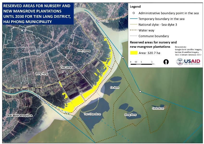
incorporated. The maps include: the state of coastal resources and their uses; conflicts arising
from multiple uses; relevant planning overlap maps; and coastal spatial planning.

                        PARTICIPATORY COASTAL SPATIAL PLANNING IN TIEN LANG DISTRICT               5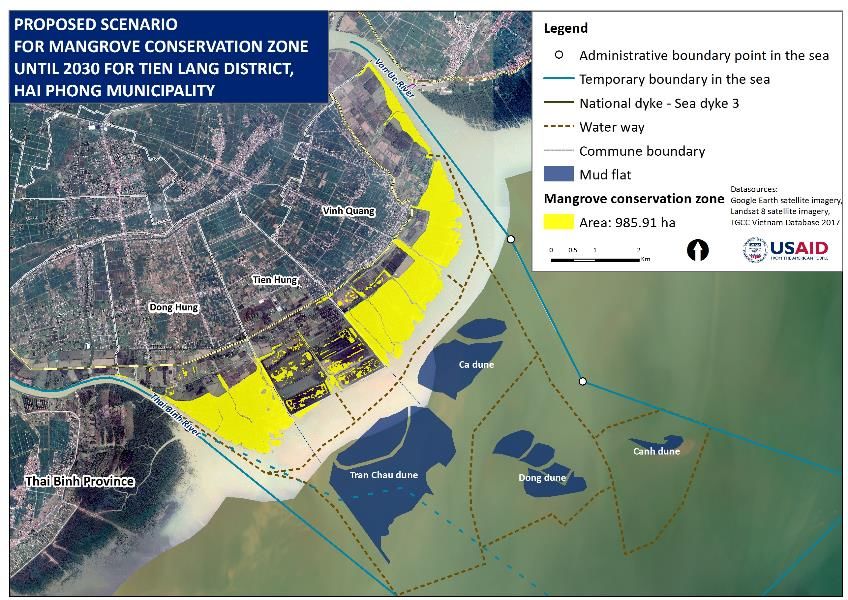
3.0 ASSESSMENT OF EXISTING
    CONDITIONS
3.1         COASTAL RESOURCE STATUS AND USE
3.1.1            Status of Coastal Resources
3.1.1.1          Mangrove Forests
There are about 5,000 hectares of tidal marshes and tidal mud flats outside the district’s sea dike,
including about 959 hectares of mangroves, calculated based on spatial analysis, while official government
statistics are at 910 hectares. 1 Mangrove forests are classified as Protected Forests which are areas used
primarily for protecting water resources, land, and erosion and are differentiated from Special-use
Forest (for conservation) and Production Forest (for timber). The dominant species of mangrove is
Rhizophora stylosa (Đước vòi) in areas of low-tide marsh and strong waves. Along the riverside there is a
scattering of Avicennia marina (mắm) and Kandela obovata (Trang) mangrove species. Most of the
mangroves are outside aquaculture ponds. There are some mangroves around shrimp ponds, but they
are not well-developed. In the PCRA workshops, most participants understood the general status of the
mangroves in their commune.
                        Table 1: Mangrove Area (Protected Forest) in Tien Lang District
                                                                   Area (ha)
      Commune              Suitable Mangrove                Classified Mangrove              Unclassified Mangrove
                              Forest Soils                          Forest                           Forest
      Đong Hung                      340                               249                                35
       Tien Hung                     187                               101                                65
      Vinh Quang                     460                               460                                0
         Total                     985.91                              810                               100
(Source: Land-use plan 2006 and Document No. 36/UBND-NN; Note: figures in the table are rounded to the nearest one)

3.1.1.2          Tidal Mud Flats and Coastal Area
According to Decree No.40/2016/NĐ-CP under the Law of Marine and Island Resources and
Environment, the coastal area includes not only the land area but also coastal waters six miles (~11 km)
out from the coastline. The Tien Lang District People’s Committee (DPC) has been authorized to
manage the coastal area from the average low tidal level to 3 km seaward.
The degree of sedimentation per day in mangrove ecosystem in Tien Lang district and Bang La commune
(Do Son district in the north of Tien Lang) is ranges from 36.69 to 151.51 g/m2/day 2. Characteristics of
tidal marshes and mud flats for the tree communes are reported in Table 2.

1   This includes 810 ha of classified mangrove forest and 100 ha of unclassified mangrove forest, as noted in the table below.
2    Nguyễn Thị Minh Huyền, Trần Mạnh Hà, Cao Thu Trang, Đặng Hoài Nhơn, Phạm Thế Thư (2011), Các giá trị sử dụng được
       mang lại từ hệ sinh thái rừng ngập mặn Tiên Lãng, Hải Phòng, Tạp chí Khoa học và Công nghệ Biển T11 (2011), Số 1.
       Tr.57-72, Viện Tài nguyên và Môi trường Biển, Hải Phòng.

6            PARTICIPATORY COASTAL SPATIAL PLANNING IN TIEN LANG DISTRICT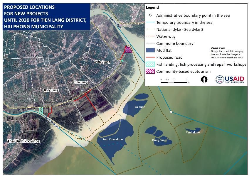
Table 2: Characteristics of Tidal Marshes and Mud Flats in Coastal Tien Lang District
                          Total                                  Degree of tidal
     Commune                                 Quality                                     Hydrological features
                        area (ha)                                submergence
                                                                 Low, exposure in      Strongly influenced by water
     Đong Hung             200        Plenty of silt sediment
                                                                    low tide           sources from Thai Binh river
                                      Mostly sandy sediment                            Strongly influenced by water
      Tien Hung            500        in coastal area close to      High, semi -       sources from Thai Binh and
                                       Vinh Quang commune         exposure in low             Van Uc rivers
                                                                        tide           Strongly influenced by water
     Vinh Quang            950        Plenty of silt sediment
                                                                                        sources from Van Uc river

3.1.1.3       Aquatic and Other Living Resources
A total of 288 species have been recorded in the tidal mangrove areas of Tien Lang district, including
around 100 species with economic, tourism, or scientific value and seven rare/protected species. There
are 30 fish species and 20 crustacean and mollusk species with economic value. 3
3.1.2         Use and Exploitation of Coastal Resources
The PCRA found four economic sectors using coastal space and resources: mangrove protection and
plantation; aquaculture in ponds, pools, and on the tidal marsh and flat; artisanal fishing by boat or hand;
and coastal and marine safety and security. There are three additional sectors which community
members identified as a priority for future development: community-based ecotourism; beekeeping; and,
raising ducks.
3.1.2.1       Mangrove Restoration and Planting
The mangrove area has changed in Đong Hung and Vinh Quang due to conversion of tidal marshes and
mud flats to shrimp ponds in the 1990s; while conversion to shrimp ponds in Tien Hung didn’t occur
until around 2002. Mangrove restoration in Đong Hung and Tien Hung has been difficult due to strong
waves and tree death related to a shipworm species. Mangrove restoration and planting in Vinh Quang
has been relatively successful. In the near future, Đong Hung tentatively plans to plant and restore 100
to 200 ha of mangrove forest, while Tien Hung would like to plan and restore 300 to 500 ha.
3.1.2.2       Aquaculture Ponds
The total area used for pond aquaculture has not changed much in recent years. The main aquaculture
species are common tiger prawn, white foot shrimp, crab, and fish. PCRA workshop attendees noted
several issues related to intensive shrimp ponds: unfavorable weather conditions due to climate change;
acid and alkaline soil; limited investment capital; water supply pollution from industrial wastewater input
from the Thai Binh and Hai Phong rivers; lack of infrastructure in Vinh Quang; and, lack of knowledge on
effective aquaculture practices in Vinh Quang.
3.1.2.3       Clam Cultivation and Nearshore Hand and Small Boat Fishing
The tidal marsh and mud flat situated outside the shrimp farming and mangrove areas of Đong Hung are
small in size and most of the marsh and flat belonging to Tien Hung is used for clam cultivation since
2016. The tidal zone outside the shrimp farming and mangroves in Vinh Quang is also used for clam
cultivation. The clam cultivation has caused some conflicts, as only a small number of households benefit,

3   Nguyễn Thị Minh Huyền, Trần Mạnh Hà, Cao Thu Trang, Đặng Hoài Nhơn, Phạm Thế Thư (2011), Các giá trị sử dụng được
     mang lại từ hệ sinh thái rừng ngập mặn Tiên Lãng, Hải Phòng, Tạp chí Khoa học và Công nghệ Biển T11 (2011), Số 1.
     Tr.57-72, Viện Tài nguyên và Môi trường Biển, Hải Phòng.

                                    PARTICIPATORY COASTAL SPATIAL PLANNING IN TIEN LANG DISTRICT                      7
due in part to the high entry costs of establishing claim farms. Remaining tidal and water areas are used
freely for fishing by hand with a range of gear including, bamboo weir, trap, seine, and other instruments.
Small boat-based fishing areas are separate by tidal creeks and nearshore waters.
3.1.3 Coastal Resource Use Rights
Per Law No.45/2013/QH13 (in force since July 2014) and Circular No.09/2013/TT-BTNMT, province,
district, and commune authorities may contract coastal areas out to local people for aquaculture or
unidentified use, or exclusively for mangrove planting. Depending on the commune, these contracts may
be for varying lengths of time. In Đong Hong, the DPC can assign or rent out land for up to 20 years,
while the Commune People’s Committees (CPCs) can assign land for only one year. In Tien Hung, Hai
Phong municipality has assigned land to two companies under contracts with limits of 50 years and 20
years. In Tien Hung and Vinh Quang, the DPC can assign land for up to 20 years and the CPCs for one
to five years. In addition, companies and individuals may make sub-agreements between themselves.
Mangrove forests are managed under Decree No.119/2016/NĐ-CP and Decision No.17/2015/QĐ-TT,
and based on this CPCs may contract households to protect mangrove forest under protective
contracts with a one year limit. The three communes each have between three and 25 households that
currently hold such contracts. Additionally, in Tien Hung, the Centre of High Technology Agricultural
Breeding has invested in mangrove plantation and protection in collaboration with the commune.
According to Document No.36/UBND-NN, all areas of forest in Tien Lang district are managed by the
DPC. In all three communes, tidal marshes and mud flats are being used for artisanal catching, clam
cultivation, and mangrove planting. Local communities have the right of open access to natural sea
product resources in the mangrove forest. In tidal areas that have been rented for clam cultivation
under two-year contracts, the households holding that contract decide what activities are permitted.
Figure 2 shows the coastal resource use status for the three coastal communes of Tien Lang District.
Figure 2: Coastal Resource Use Status in Đong Hung, Tien Hung, and Vinh Quang
8 PARTICIPATORY COASTAL SPATIAL PLANNING IN TIEN LANG DISTRICT3.2 CONFLICTS AND OVERLAPS IN RESOURCE USE AND
PROPOSED SOLUTIONS
At project workshops, stakeholders collaborated to identify conflicts and overlapping resource use,
along with their locations, the reasons for the conflicts, and proposed solutions. The conflicts and
overlaps identified are reported in the below table and visualized in Figure 3.
Table 3: Current Coastal Resource Use Conflicts and Overlaps
Conflicts and Conflict
Conflict Description and Causes Proposed Solutions
Obstacles Location
Cross-sectoral: Mainly conflict between conservation (mangrove forest protection) and development
Conflicts between Mangrove plantation narrows exploitative Strictly penalize violations; forbid All three
mangrove planters space of catchers. electric fishing, or use of too small- communes
or protectors Catchers cause impacts to newly planted sized net.
(conservatists) mangroves. Increase awareness of importance of
with aquatic Mangrove protectors prevent catchers mangrove forest protection and role
resources catchers from fishing, so fish catchers cuts the of stakeholders.
mangrove seedlings. Create sustainable alternative
Catcher destroys mangrove forest to set livelihoods for local communities.
nets and weirs. Those setting up weirs should avoid
Small boats comes into the forests for newly planted forest.
protection during high tide. Tighten the rules for use of nets and
weirs in the forest.
Negotiate benefit sharing between
forest planters and fish catchers
through the development of rules and
regulations of resource exploitation
inside assigned mangrove forests.
Between Aquaculturist tries to keep natural breeds Intervention of management through All three
aquaculturists and of fish in pond but fishermen use electric authority. communes
fish catchers fishing or chemicals to fish.
Mangrove planters Both sides need the same coastal space Zone space for both mangrove Đong
and aquaculturists for project development due to planning planting and aquaculture farming. Hung, Vinh
overlap. Quang
Fish catchers using Limited local awareness of coastal Strengthen awareness for the local Outside
electric fishing resources. people, especially the catchers. and inside
devices and Forbid electric fishing. of sea-dike
aquaculturists and in all three
other catchers communes
Clam farmers and Clam farmers expands farm into area of Ensure clam farmers do not expand Vinh
hand-catchers hand-catcher, narrowing catching area. without permission. Quang,
Clam farmers prevent small net fishers Clearly mark boundaries of clam bed Tien Hung
from using the space needed. grounds.
Hand-catching causes impacts to the clam Ensure that clam farming and catching
cultivation ground. are not assigned to the same areas.
Clam farming and Clam farmers invaded into weir space Manage clam farming and setting of Vinh
weir setting weirs; register aquaculture areas and Quang,
weir areas to avoid overlap. Tien Hung
PARTICIPATORY COASTAL SPATIAL PLANNING IN TIEN LANG DISTRICT 9Conflicts and Conflict
Conflict Description and Causes Proposed Solutions
Obstacles Location
Clam farming and Catching inside the clam beds impacts Clam cultivation ground planning and Tien Hung,
boat-fishers clam cultivation. design. Vinh
Setting up oyster cultivation markers Maintain a narrow passage for boat Quang
prevents boat activity. activity.
Some clam farmers use cement marks Forbid and penalize clam farmers
which can damage boats. from transgressing outside their
Clam farmers transgress onto fishing assigned area.
grounds of small fishers. Forbid clam farming households from
Clam farmers prevent boat-fishers from setting up cement marks.
using the same space.
Between weir Setters of weirs limit by-hand catching. Identify the rights and interests; All three
setters and hand- ensure setters of weirs allows communes
catchers traditional catchers to share benefits.
Between weir Setting weir expands and prevents narrow Plan weir areas with a narrow All three
setters and boat- passage for boat activity. passages for boat activity communes
fishers
Within Sectors
Lack of consensus Time limits on land use and rent contracts Identify the land rent time limit All three
between in tidal zones are different between following Law of Land newly by communes
authorities on communes and provide uncertainties for Decree No.119/2016/NĐ-CP
time limit of use households and businesses.
contracts
Conflicts between Overlapping catch areas. Improve management coordination All three
the catchers using between the local authority and communes
the same mangrove forest protector.
instrument Improve zoning of catch areas.
Provide information for each
stakeholders on rights and
responsibilities.
Develop sanctions and guidelines for
fishing and catch (electric catch, and
catching small sizes)
Conflicts between Conflicts in the assigned areas. Plan different aquacultural forms in Đông
intensive different zones. Hưng, Vinh
aquaculture Quang,
cultivation and Tiên Hưng
semi-intensive and
extensive
cultivation
Conflicts between Overlapping location of exploitation. Better zonation and design areas. Mainly
those using nets Setters of weirs conduct zoning and Involve stakeholders to protect inside old
and hand catching: coastal management but by-hand catchers. coastal and marine resources and mangrove
Between setters environment for common benefits. forest.
of weirs, of net, Develop co-management teams to Đông
with by-hand harmonise benefits of stakeholders. Hưng, Vinh
catchers and by- Quang.
Development management
boat fishers. Tiên Hưng
regulations.
10 PARTICIPATORY COASTAL SPATIAL PLANNING IN TIEN LANG DISTRICTFigure 3: Conflicts in Current Resource Uses in Coastal Communes of Tien Lang District
3.3 REVIEW OF PLANS IN RELEVANT SECTORS
In order to develop the future coastal development scenarios and identify potential conflicts or overlaps
in the use of coastal spatial areas and resources, it is necessary to consider development planning of
related sectors to 2025 and 2030. In the framework of coastal area development of Tien Lang district,
the project team collected and integrated sectoral plans from the national, provincial, and district levels
that will affect the coastal area during the planning period. These plans included:
• The national biodiversity conservation plan to 2020 and orientation to 2030 (08/01/2014);
• Planning for the location of Hai Phong International Airport (28/04/2011);
• Adjusting and supplementing the overall planning for socioeconomic development of Hai Phong
municipality to 2020 (27/11/2006);
• Forest protection and development planning of Hai Phong municipality to 2020 (25/07/2013);
• Fisheries economic development planning in Hai Phong municipality for the period 2016 to 2025
and orientation to 2030 (01/04/2016); and,
• Land use planning to 2020 for Hai Phong municipality and Tien Land District.
Communities also added their own input on plans or projects they were aware of. These included
national civil roads, which will pass through the coastal communes’ paddy and residential areas; work on
the sea-dike; development planning for coastal aquaculture and fishing at the district level (in draft status,
not yet approved); the project to plant protective forest, being carried out by women in the communes
each year; and, the planning for mining in the city to 2020 with a vision to 2030.
PARTICIPATORY COASTAL SPATIAL PLANNING IN TIEN LANG DISTRICT 11Of these items, the largest impact would come from the planning for Hai Phong International Airport,
which would be located in the coastal communes of Tien Lang district. Tien Lang is one of three sites
being considered by government for this airport. If this project is implemented, coastal alluvial grounds,
as well as residential and cultivated land inside the dike will be affected. The runways and associated
facilities will require an area of over 4,500 ha, which will have a transformative effect on the communes.
The entire mangrove forests of Đong Hung and Tien Hung, and most of the mangrove area in Vinh
Quang, would be replaced by the airport facilities as currently projected.
The fisheries planning shows the entire water surface area identified in the commune as being used for
aquaculture.
According to discussion with the communities, the planning of the coast and the development of a new
dike for the district has not yet been defined. However, if the seawall is extended, this will certainly
change the current land use status of the coastal alluvial grounds. The outside dike areas will continue to
be affected by sedimentation and erosion, and areas inside the dike will be gradually converted to
economic development use rather than their current conservation purposes.
The coastal areas of Đong Hung and Tien Hung have a mangrove forest system along the Thai Binh
estuary, extending to the sea. If the biodiversity conservation planning goes forward as planned and a
biosphere reserve area is established, it will include parts of this mangrove forest system. The Hai Phong
forest protection planning will maintain all of the current protected forest areas in parallel with new
planting and rehabilitation project so protected forest areas in the three communes would be
maintained and expanded.
Figure 4 shows where these various sectoral plans overlap in their planning for the coastal communes.
Figure 4: Overlaps in Relevant Spatial Use Plans in Coastal Communes of Tien Lang District
12 PARTICIPATORY COASTAL SPATIAL PLANNING IN TIEN LANG DISTRICT3.4 IMPACTS OF CLIMATE CHANGE ON COASTAL AREAS OF
TIEN LANG DISTRICT
The project team introduced basic concepts and terminology around climate change to workshop
participants. Subsequently, information from the Climate Change Scenario for Vietnam promulgated by
the Ministry of Natural Resources and Environment (MONRE), combined with research from projects
related to climate change in Hai Phong, was presented to participants to stimulate a discussion on the
potential impacts of climate change to Hai Phong in general and to the coastal areas of Tien Lang district
in particular. Key impacts identified, include: changes in temperature and rainfall; increased risk of floods
due to sea level rise; and, sea level rise caused by storms and tides. According to information from
MONRE, the coastal areas of Tien Lang district in particular and Hai Phong municipality in general are
among those most affected in the nation by storms, both in terms of number of storms and their impact.
The highest sea level rise caused by storms in this area is up to four meters, with a total sea level rise of
up to six meters if a storm occurs at high tide. In September 2017, for exampleTyphoon Doksuri led to
a 4.4 meter rise in the Thai Binh estuary. This overflowed the sea dikes and impacted pond aquaculture
areas. In heavy mangrove forests areas, the impacts were substantially reduced. Thus, maintenance,
protection, and development of the coastal mangrove forest play an important role in limiting the
impacts and damages caused by storms triggered by climate change.
Participants assigned levels of severity to the impacts of climate change on Tien Lang district, with one
indicating a very weak impact and five indicating a very strong impact. The majority of groups assigned
very strong impact (level five) to sea level rise due to storms combined with high tides; extreme
weather events and the risk of floods due to sea level rise were considered strong impact (level four);
and, changes in temperature and rainfall were considered as moderate impact (level three).
PARTICIPATORY COASTAL SPATIAL PLANNING IN TIEN LANG DISTRICT 134.0 DEVELOPMENT OF
COASTAL SPATIAL
PLANNING SCENARIOS FOR
TIEN LANG DISTRICT
4.1 DEVELOPMENT OF PLANNING VISIONS
The process of developing spatial planning visions for the three coastal communes in the project area
started with the project team giving an introduction of the spatial planning concept to the local
communities and stakeholders. Then workshop participants broke into small groups to discuss their
visions for their communes. Participants were encouraged to identify broad development goals for the
communes over short- and medium-term timeframes and then begin to consider how sector goals may
contribute to reaching this holistic vision. During these discussions in each commune as well as the
district workshop, participants discussed the following sectors and activities: mangrove conservation;
sustainable pond aquaculture development; sustainable artisanal boat capture fisheries development;
sustainable hand capture fisheries development; sustainable livelihoods and incomes; adaptation to
climate change impacts to reduce damages and losses from natural hazards; and, contributions to
marine/coastal security. In addition, sustainable clam farming development was suggested in Tien Hung
and Vinh Quang, while sustainable ecotourism development was suggested in Vinh Quang.
The project team analyzed and integrated the ideas generated by workshop participants into an
integrated vision for each commune, which was then discussed in plenary at the commune-level
workshop. Commune and district authorities validated the following spatial planning visions:
• Towards 2030, Đong Hung coastal areas will be efficiently developed with thick mangrove
forests and abundant fisheries resources. Coastal economic sectors will be developed in
harmonization with coastal environmental protection and climate change adaptation, and will
bring sustainable incomes for local people.
• Towards 2030, Tien Hung coastal areas will be sustainably developed. Conflicts between
different sectors over coastal spatial resource use will be mitigated. Mangrove forests will be
protected and expanded. Local livelihoods will be improved and sustained, and well-adapted to
climate change impacts.
• Towards 2030, mangrove forests in Vinh Quang coastal areas will be well conserved and
expanded, ensuring sustainable economic development in harmonization with environmental
protection and climate change adaptation. Local livelihoods will be sustained. Vinh Quang coastal
areas will be an ecotourism destination within Hai Phong municipality.
• Towards 2030, district coastal areas will be sustainably developed with thick mangrove forests
and abundant fisheries resources. Coastal economic sectors will be sufficiently developed, in
harmonization with coastal environmental protection, climate change adaptation, and marine
security assurance, and will bring sustainable livelihoods and incomes for local people.
14 PARTICIPATORY COASTAL SPATIAL PLANNING IN TIEN LANG DISTRICT4.2 DEVELOPMENT OF PLANNING TARGETS
At the commune participatory workshops, local stakeholders also developed planning targets, working
together in small groups with guidance from the project team. Although detailed numbers in planning
targets across breakout groups varied, all groups had significant similarities in their proposed targets.
The project team then led a plenary discussion of the targets suggested by each group to determine final
targets for each commune.
Table 4: Planning Targets for Each Commune and District Coastal Area Through 2030
Planning Targets
Item Total District Coastal
Vinh Quang Tien Hung Đong Hung
Area
Conservation Targets
Mangrove forest 460 ha (2017) 187 ha (2017) 340 ha (2017) 986 ha (2017)
conservation areas 500 ha (2025) 270 ha (2025) 400 ha (2025) 1,170 ha (2025)
550 ha (2030) 350 ha (2030) 440 ha (2030) 1,340 ha (2030)
Mangrove forest 50 ha (2025) 80 ha (2025) 135 ha (2025) 265 ha (2025)
replantation areas (ha) 50 ha (2030) 80 ha (2030) 40 ha (2030) 160 ha (2030)
Resource Use Targets
Pond aquaculture areas Maintain existing Maintain existing Maintain existing Maintain existing area of
(ha) area of 365 ha area of 544 ha area of 329 ha 1,238 ha
Maintain existing Maintain existing 0 Maintain existing area of
Clam farming areas (ha)
area of 150 ha area of 210 ha 360 ha
In mangrove In mangrove In mangrove In mangrove forests and
forests and tidal forests and tidal forests and tidal tidal flats; 1,571 ha (986
flats; 460 ha flats; 187 ha flats; 340 ha ha mangrove forests)
Hand capture fisheries (2017); 500 ha (2017); 270 ha (2017); 400 ha (2017); 1,571 ha (1,170
areas (ha) (2025); 550 ha (2025); 350 ha (2025); 440 ha ha mangrove forests)
(2030) (2030) (2030) (2025); 1,571 ha (1,340
ha mangrove forests)
(2030)
100% (2017) 100% (2017) 100% (2017) about 100% (2017) about 271
about 200 boats about 21 boats 50 boats boats
Artisanal boat capture ↑ 120% (2025) - ↑ 150% (2025) - ↑ 120 % (2025) - ↑ 130 % (2025) - 330
fisheries areas (ha) 240 boats 30 boats 60 boats boats
↑ 130% (2030) - ↑ 200% (2030) - ↑ 150% (2030) - 75 ↑ 160% (2030) - 375
260 boats 40 boats boats boats
Existing Conflict ↓50% (2025) ↓40% (2025) ↓ 50% (2025) ↓ 47% (2025)
Mitigation Targets ↓100% (2030) ↓90% (2030) ↓ 90% (2030) ↓ 93% (2030)
Household Income ↑15% (2025) ↑50% (2025) ↑ 50% (2025) ↑ 38% (2025)
Targets ↑30% (2030) ↑80% (2030) ↑ 100% (2030) ↑ 70% (2030)
4.3 COASTAL SPATIAL ZONING SCENARIOS
A functional zoning use of coastal areas must take into consideration several principles and criteria,
including natural features, natural functions of the ecosystem, and use of coastal resources; benefits and
social features of coastal areas; potential for reorganization of current situtations in the management of
coastal resources; and, following up on visions and management objectives while minimizing current
conflicts and addressing overlaps in relevant planning.
PARTICIPATORY COASTAL SPATIAL PLANNING IN TIEN LANG DISTRICT 15Based on analysis of the socioeconomic conditions in the three communes, strategic orientations for
economic development in the future, and current conflicts in the management and use of coastal
resources, the total area of 9,844 ha is proposed to be divided as outlined in the table below.
Table 5: Summary of Coastal Spatial Planning Zoning Scenario
Percentage of Total
Sector Area (ha)
Area*
Conservation areas
Conservation, protection and rehabilitation of mangrove 986 10%
Transitional, low intensity areas
Hand capture fisheries areas 1,571 16%
Areas of fixed nets, lift nets, traps 276 3%
Development areas
Planning pond aquaculture areas 1,019 10%
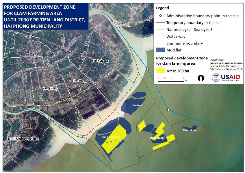
Planning clam farming areas 360 4%
Artisanal boat capture fisheries areas 6,794 69%
Planning areas of anchorage and landing of fish wharves, fish
11Figure 5: Areas of Conservation, Protection, and Rehabilitation of Mangrove Forests
Figure 6: Hand Capture Fisheries Areas
PARTICIPATORY COASTAL SPATIAL PLANNING IN TIEN LANG DISTRICT 17Figure 7: Areas of Fixed Nets, Lift Nets, and Traps
The area of fixed nets, lift nets, and trap will be gradually reduced; by 2025 there will no longer be areas of
fixed nets, lift nets, and traps. It will be replaced by new plantation of forests.
Figure 8: Pond Aquaculture Areas
18 PARTICIPATORY COASTAL SPATIAL PLANNING IN TIEN LANG DISTRICTPond aquaculture areas are outer areas of the dike within the scope of this planning. Areas are calculated
from the map including the embankment areas and water surface areas for aquaculture.
Figure 9: Clam Farming Areas
Figure 10: Artisanal Boat Capture Fisheries Areas
PARTICIPATORY COASTAL SPATIAL PLANNING IN TIEN LANG DISTRICT 19Figure 11: New Project Areas
Figure 12: Reserve Areas for Future Economic Activities
20 PARTICIPATORY COASTAL SPATIAL PLANNING IN TIEN LANG DISTRICTFigure 13: Reserve Areas for New Plantation of Protection Forests
PARTICIPATORY COASTAL SPATIAL PLANNING IN TIEN LANG DISTRICT 21Figure 14: Spatial Planning for Coastal Areas of Tien Lang District to 2030 22 PARTICIPATORY COASTAL SPATIAL PLANNING IN TIEN LANG DISTRICT
5.0 DEVELOPMENT OF A
    SPATIAL MANAGEMENT
    PLAN FOR TIEN LANG
    COASTAL AREAS
Commune coastal spatial management plans were developed at participatory workshops held in each
commune. At each workshop, participants went through two practical exercises: the first identified
management objectives; and the second formulated management activities, associated outputs, and
required resources (timeframe, budget, human resource) for implementation. Within each of these
workshops, the participants reviewed the products of the coastal spatial planning workshops and the
maps produced. Participants used the visions and targets to inform the management activities and the
scenarios to help consider the necessary tradeoffs. Workshop participants were divided into three
groups representing three key coastal spatial and resource user groups: pond aquaculture and clam
farming; artisanal boat fishing; and, hand fishing. Mangrove forest conservation and cross-cutting
economic activities were discussed by all three groups.
Discussion outputs were organized in management plan tables with associated maps and then presented
in plenary. The project team worked with participants to integrate the outputs from each group into
commune and district management objectives and activities as follows:
    •   In Đong Hung, the management objectives were related to conservation and
        expansion/enrichment of mangrove forests and nearshore fisheries resources; sustainable
        development of coastal economic activities in harmonization with environmental protection and
        climate change adaptation; and, local social stabilization and marine security and sovereignty.
    •   In Tien Hung, the management objectives were related to sustainable development of local
        livelihoods and coastal economic activities in harmonization with environmental protection and
        climate change adaptation; protection of the coastal environment to ensure a clean, beautiful,
        and green coast; and, stabilization of local security and social welfare via successful conflict
        resolution.
    •   For Vinh Quang, the management objectives were related to local social security and welfare
        stabilization through successful conflict resolution; conservation and expansion of mangrove
        forests and nearshore fisheries resources; and, sustainable development of coastal economic
        activities in harmonization with environmental protection and climate change adaptation.
Following the commune level workshops, an inter-commune workshop was held. The management
objectives from the three communes were synthesized into a set of management objectives for the
district coastal area. Those objectives are to sustainably conserve and develop mangrove forests and
nearshore fisheries resources; sustainably develop coastal economic activities in harmonization with
environmental protection and climate change adaptation; and, increase local social stabilization and
welfare and ensure local marine sovereignty.
Once the management objectives were agreed at the commune and district levels, management activities
in keeping with these objectives were also finalized and required resources and implementation
timeframes were identified. Activities from commune-level management plans were integrated into a
coastal spatial management plan for the Tien Lang district coastal areas. Table 6 summarizes that plan.
                               PARTICIPATORY COASTAL SPATIAL PLANNING IN TIEN LANG DISTRICT            23
Table 6: Management Activities for the Coastal Area of Tien Lang District
Funding Priority
Implementing Agencies Required Level (1 =
Activity Expected Results Duration
(* = lead) (million low, 5 =
VND) high)
Management activities relating to aquaculture in ponds and on intertidal zones
Unify time of allocation and lease of aquaculture MPC*, DPC*, CPCs*, related Pond aquaculture areas 2018 - 500 4
land, signing the contract with the commune:Strengthen the capacity of fishermen in capture Hai Phong DoF*, Tien Lang district The capacity of capture 2020 - 1.000 4
fisheries techniques in offshore areas by giving DoA, related organizations, local fisheries in offshore areas 2025
two to three courses per year. fishers is strengthened.
Build and upgrade small-scale fishing landings in Hai Phong DoF*, Tien Lang district Fish landings are equipped 2020 - 10,000 4
Đong Hung and Vinh Quang, equipped with DoA, related organizations, with logistic service 2025
logistic service facilities for fishery. communities facilities for fishery.
Management activities relating to the protection, conservation and rehabilitation of mangrove forest
Plant new mangroves in appropriate areas, CPCs*, related organizations, 20-30 ha of mangrove 2018 - 1,000 5
manage new planted and replanted forests, re- communities forest are planted annually 2030
plant mangroves when they die or fall due to (total about 280-310 ha).
storms, winds and natural disasters.
Establish a mechanism for allocation and MPC*, DPC*, CPCs, and 100% of forest areas are 2018 - 300 5
development of mangrove forest to communities allocated with the unified 2020
communities in accordance with Decree mechanism.
119/2016/ND-CP.
Management activities of other sectors
Develop ecotourism models based on Tien Lang district Department of One to two ecotourism 2020 - 500 3
communities in suitable communes (pine forest Culture and Information*, commune models based on 2025
areas, mangroves, etc.). authorities, tourism enterprises, communities are
related households operated.
Upgrade the tourist port in Vinh Quang DPC*, Vinh Quang commune, The tourist port is 2025 - 2,000 4
commune for community ecotourism. communities, aid organizations upgraded. 2030
Develop new livelihoods from coastal Tien Lang district DoA*, New livelihood models 2018 - 300 4
resources, such as bee keeping, and new Agricultural Extension Center*, are developed. 2020
activities such as oyster hanging in mangroves, communities
or duck farming in shrimp ponds.
General management activities
Sensitize communities on forest protection and CPCs*, related organizations, 100% of people are 2018 - 350 4
a ban on electric fishing through trainings, communities sensitized. 2025
theater contest, school competition, etc.
Organize waste collection and quarterly beach Commune Youth Unions*, CPCs, Waste collection activities 2018 - 150 4
cleanup activities. communities, socio-political are organized quarterly. 2030
organizations
Invest in infrastructure on intertidal zones, MPC*, DPC*, CPCs, DARD, The dike is upgraded to 2018 - 70,000 3
upgrade surface of the national dike to facilitate projects, communities ensure movement. 2020
movement and transportation and roads linking
aquaculture areas.
PARTICIPATORY COASTAL SPATIAL PLANNING IN TIEN LANG DISTRICT 256.0 CONCLUSIONS AND
RECOMMENDATIONS
The coastal alluvial areas of Tien Lang district are characterized by abundant resources, including
fisheries resources with high economic values, and ecosystems with mangrove forests. These areas also
have high economic development potential and play an important role in generation of incomes and
livelihoods of local people. There are four coastal economic sectors, mangrove protection and
plantation; aquaculture in ponds, pools, and on the tidal marsh and flat; artisanal fishing by boat or hand;
and coastal and marine safety and security, making use of coastal resources and spaces for their
development, and other potential economic activities that may wish to use those resources in the
future.
However, the development of those coastal economic activities has led to conflicts and overlaps in
resource and spatial uses, including both inter-sectoral and within-sector conflicts. Additional conflicts
and overlaps may arise in the future without careful spatial planning and management.
To achieve the vision established by the local communities through participatory workshops, the project
worked with communities to establish spatial zoning scenarios with four key zones: (1) a mangrove
conservation zone; (2) a buffer zone for low intensity uses; (3) development zones for pond aquaculture,
clam farming, boat fishing, and fish landing and processing; and, (4) reserved zones for future economic
development with low environmental impact. Additionally, coastal spatial planning management and
objectives through 2030 were established for both the commune and district levels.
To be implemented, the plans require approval at the provincial level by the PPC. From this level, the
plans can be subsequently integrated into broader development plans. The acceptance and
implementation of the spatial management plan is by no means assured as this planning process
represents a much finer scale than typical planning carried out in Vietnam. As noted in the project
lessons learned document, though national level MARD has a strong interest in the product and process
deployed in Tien Lang and the district stakeholders have identified the value of the process to address
local disputes and planning needs, provincial stakeholders have been the hardest to engage in the
activity. It is expected that the plans will be brought to the PPC through broader planning processes by
DPC leadership. The plan and process carried out in Tien Lang represent a proof of concept to
demonstrate to district and national government of the viability of a participatory and multi-sector
approach. Rather than proposing a specific timeline for this approval, the team recognizes that it will
require a champion and a willingness to find openings for engagement of the PPC. Assuming that the
plan is ultimately approved and becomes a framework for implementation, six key measures should be
implemented to operationalize the spatial planning scenarios and management plans:
• Develop and strengthen inter-sectoral coordination mechanisms;
• Establish and implement inter-sector monitoring institutional arrangements;
• Promote public communications on approved coastal spatial planning scenarios and management
plans;
• Formulate a mechanism to raise funds to implement the scenarios and management plans;
• Implement the approved coastal spatial planning scenarios and management plans; and,
• Establish a mechanism for monitoring and evaluation of spatial planning implementation.
26 PARTICIPATORY COASTAL SPATIAL PLANNING IN TIEN LANG DISTRICTFurther recommendations are to continue to improve local capacity for participatory planning through
on-the-job training and other methods; and, to ensure that an agency or department is assigned to
monitor implementation of the spatial planning and management plan and adjust scenarios and plans as
needed to balance coastal conservation and economic development.
PARTICIPATORY COASTAL SPATIAL PLANNING IN TIEN LANG DISTRICT 27ANNEX A: RELEVANT LEGISLATION Law of Marine and Island Resources and Environment approved by XIII National Assembly dated 25 June 2015 (in force since 1 July 2016) Law of Environmental Protection enacted in National Assembly document No.55/2014/QH13 dated 23 June 2014 and in force since 01 January 2015 Law of Land enacted in National Assembly document No.45/2013/QH13 dated 20 November 2013 Law of Vietnam Sea enacted in National Assembly document No.18/2012/QH13 dated 21 June 2012 Law of Fisheries enacted in 2003 Decree No.119/2016/NĐ-CP approved by the Vietnam Government dated 23/8/2016 on policies for the sustainable development, protection and management of coastal forests for adapting to climate change Decree No.89/2015/NĐ-CP dated 07/10/2015 of the Vietnam Government regarding amendment of Decree No.67/2014/NĐ-CP focused on policies for fisheries development Decree No.67/2014/NĐ-CP dated 07/07/2014 of the Vietnam Government on some policies for fisheries development Decree No.33/2010/NĐ-CP dated 31/3/2010 of the Vietnam Government on fisheries management Decree No.40/2016/NĐ-CP dated 15/5/2016 of the Government of detail regulation for execution of some iterms in Law of Marine and Island Resources and Environment Circular No.28/2014/BTNMT dated 02/6/2014 of Minister of Ministry of Natural Resources and Environment (MONRE) regulated about land statistics, invemtory and mapping land-use state Circular No.09/2013/BTNMT dated 28/05/2013 of MONRE Minister regulated about management, use for coastal and reverside land and tidal wetlands Decision No.2295/2014/QĐ-TTg of Prime Minister dated 17/12/2014 about approval of Integrated Coastal Management Strategy of Vietnam towards 2020, vision 2030 Decision No.45/QĐ-TTg dated 08/01/2014 of Prime Minister about approval of Master-plan of Biodiversity Conservation of Vietnam towards 2020, vision 2030 Decision No.1445/QĐ-TTg dated 16/08/2013 Prime Minister about approval of Master-plan of Fisheries Development of Vietnam towards 2020, vision 2030 Decision No.1570/2013/QĐ-TTg dated 06/09/2013 of Prime Minister about approval of Strategy on Sustainably Marine and Island Environmental and Resource Use, Exploitation and Protection Marine of Vietnam towards 2020, vision 2030 Decision No.1349/2011/QĐ-TTg dated 09/8/2011 of Prime Minister about Approval of Amendation for Planning of Anchoring and Storm Hiding Locations for Fishing Ship towards 2020, vision 2030 28 PARTICIPATORY COASTAL SPATIAL PLANNING IN TIEN LANG DISTRICT
Decision No.1690/2010/QĐ-TTg dated 16/09/2010 of Prime Minister about Approval of Strategy on
Vietnam Fisheries Development towards 2020
Decision No.789/QĐ-TTg dated 11/5/2016 of Prime Minister about Enaction of Plan to implement the
Strategy on Sustainably Marine and Island Environmental and Resource Use, Exploitation and Protection
Marine of Vietnam towards 2020, vision 2030
Decision No.914/QĐ-TTg dated 27/5/2016 of Prime Minister about Approval of Action Plan to
Implement the Strategy on Integrated Coastal Management of Vietnam towards 2020, vision 2030
Decision No.640/QĐ-TTg dated 28/04/2011 of Prime Minister about Approval of Planning for
International Airport Location in Hai Phong
Decision No.271/2006/QĐ-TTG dated 27/11/2006 of Prime Minister about Approval of Amendation,
Add to Master-plan on Socio-Economic Development of Haiphong City towards 2020
Decision No.17/2015/QĐ-TTg dated 09/06/2015 of Prime Minister about Promulgation of Protective
Forest Management Regulation
Resolution No.12/NQ-HĐND dated 20/07/2017 of Haiphong City People Council endorsed
Amendation of Master-plan on Land-use planning towards 2020 and Plan on Land-use in the period of
2016-2020 of Hai Phong city
Decision No.1600/QĐ-UBND dated 21/08/2013 of Haiphong City People Commitee about approval of
Forest Development and Protection Planning of Haiphong city towards 2020
Decision No.538/QĐ-UBND dated 01/04/2016 of Haiphong City People Commitee about approval of
Fisheries Economic Development Planning of Haiphong city in period of 2016 - 2025, oriented towards
2030
Decision No.1805/QĐ-UBND of Haiphong City People Commitee dated 6/8/2015 about approval of
Mineral Planning in Haiphong city towards 2020, Vision to 2030
Decision No.1478/QĐ-UBND dated 12/06/2017 of Haiphong City People Commitee about
Implementation of Delimitation for Temporary Fronties for Sea Administrative Management
Document No.36/UBND-NN dated 10/01/2017 of Tien Lang District People Commitee aimed to
promote solutions of the riverside and coastal mangvove protection

                              PARTICIPATORY COASTAL SPATIAL PLANNING IN TIEN LANG DISTRICT          29
U.S. Agency for International Development
1300 Pennsylvania Avenue, NW
Washington, D.C. 20523
Tel: (202) 712-0000
Fax: (202) 216-3524
www.usaid.gov
30 PARTICIPATORY COASTAL SPATIAL PLANNING IN TIEN LANG DISTRICTYou can also read