PLANET IMAGERY PRODUCT SPECIFICATIONS - Planet Labs
←
→
Page content transcription
If your browser does not render page correctly, please read the page content below
PLANET IMAGERY
PRODUCT SPECIFICATIONS

SUPPORT@PLANET.COM | PLANET.COM   LAST UPDATED JANUARY 2018
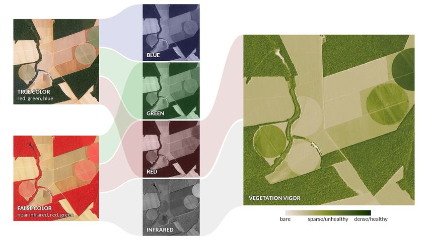
TABLE OF CONTENTS

LIST OF FIGURES ________________________________________________________________________________________ 3
LIST OF TABLES _________________________________________________________________________________________ 4
GLOSSARY _____________________________________________________________________________________________ 5

1. OVERVIEW OF DOCUMENT ______________________________________________________________________________ 7
  1.1 Company Overview __________________________________________________________________________________ 7
  1.2 Data Product Overview _______________________________________________________________________________ 7

2. SATELLITE CONSTELLATION AND SENSOR OVERVIEW ______________________________________________________ 8
  2.1 PlanetScope Satellite Constellation and Sensor Characteristics _______________________________________________ 8
  2.2 RapidEye Satellite Constellation and Sensor Characteristics _________________________________________________ 8
  2.3 SkySat Satellite Constellation and Sensor Characteristics ____________________________________________________ 9

3. PLANETSCOPE IMAGERY PRODUCTS_____________________________________________________________________ 10
  3.1 PlanetScope Basic Scene Product Specification __________________________________________________________ 10
  3.2 PlanetScope Ortho Scenes Product Specification __________________________________________________________ 11
    3.2.1 PlanetScope Visual Ortho Scene Product Specification __________________________________________________ 12
    3.2.2 PlanetScope Analytic Ortho Scene Product Specification _______________________________________________ 13
  3.3 PlanetScope Ortho Tile Product Specification ____________________________________________________________ 14
    3.3.1 PlanetScope Visual Ortho Tile Product Specification ___________________________________________________ 15
    3.3.2 PlanetScope Analytic Ortho Tile Product Specification _________________________________________________ 16

4. RAPIDEYE IMAGERY PRODUCTS ________________________________________________________________________ 18
  4.1 RapidEye Basic Scene Product Specification ____________________________________________________________ 18
  4.2 RapidEye Ortho Tile Product Specification ______________________________________________________________ 20
    4.2.1 RapidEye Visual Ortho Tile Product Specification _____________________________________________________ 20
    4.2.2 RapidEye Analytic Ortho Tile Product Specification ___________________________________________________ 22

5. SKYSAT IMAGERY PRODUCTS ___________________________________________________________________________ 23
  5.1 SkySat Basic Scene Product Specification _______________________________________________________________ 23
  5.2 SkySat Ortho Scene Product Specification ______________________________________________________________ 24
    5.2.1 SkySat Visual Ortho Scene _______________________________________________________________________ 24
    5.2.2 SkySat Pansharpened Multispectral Ortho Scene _____________________________________________________ 25
    5.2.3 SkySat Analytic DN Ortho Scene __________________________________________________________________ 25
    5.2.4 SkySat Panchromatic DN Ortho Scene ______________________________________________________________ 26

6. OTHER PROVIDER IMAGERY PRODUCTS__________________________________________________________________ 27
  6.1 Landsat 8 Product Specification _______________________________________________________________________ 27
  6.2 Sentinel-2 Product Specification ______________________________________________________________________ 28

7. PRODUCT PROCESSING________________________________________________________________________________ 29
  7.1 PlanetScope Processing _____________________________________________________________________________ 29
  7.2 RapidEye Processing ________________________________________________________________________________ 31
  7.3 SkySat Processing __________________________________________________________________________________ 32
  8. QUALITY ATTRIBUTES_______________________________________________________________________________ 33

© Planet Labs Inc 2018                                                                                         Page 2
8.1 Product Geometric Positional Accuracy _________________________________________________________________ 33
  8.2 Cloud Cover _______________________________________________________________________________________ 33
    8.2.1 PlanetScope ____________________________________________________________________________________ 33
    8.2.2 RapidEye ______________________________________________________________________________________ 33
  8.3 Band Co-Registration _______________________________________________________________________________ 34
    8.3.1 PlanetScope ___________________________________________________________________________________ 34
    8.3.2 RapidEye ______________________________________________________________________________________ 34
    8.3.3 SkySat ________________________________________________________________________________________ 34
  8.4 Radiometry and Radiometric Accuracy _________________________________________________________________ 35
    8.4.1 PlanetScope ___________________________________________________________________________________ 35
    8.4.2 RapidEye _____________________________________________________________________________________ 35

9. PRODUCT METADATA _________________________________________________________________________________ 37
  9.1 Ortho Tiles ________________________________________________________________________________________ 37
    9.1.1 PlanetScope ___________________________________________________________________________________ 37
    9.1.2 RapidEye ______________________________________________________________________________________ 38
  9.2 Ortho Scenes ______________________________________________________________________________________ 39
    9.2.1 PlanetScope ___________________________________________________________________________________ 39
    9.2.2 SkySat ________________________________________________________________________________________ 40
  9.3 Basic Scenes ______________________________________________________________________________________ 41
    9.3.1 PlanetScope ___________________________________________________________________________________ 41
    9.3.2 RapidEye ______________________________________________________________________________________ 42
    9.3.3 SkySat ________________________________________________________________________________________ 43

10. PRODUCT DELIVERY _________________________________________________________________________________ 44
  10.1 Planet Application Programming Interface (API) _________________________________________________________ 45
  10.2 Planet Graphical User Interface (GUI) __________________________________________________________________ 47
  10.3 Planet Account Management Tools ____________________________________________________________________ 47
  10.4 File Format _______________________________________________________________________________________ 48
  10.5 Bulk Delivery Folder Structure _______________________________________________________________________ 48

APPENDIX A - IMAGE SUPPORT DATA ______________________________________________________________________ 49
  1. General XML Metadata File ____________________________________________________________________________ 49
  2. Unusable Data Mask File ______________________________________________________________________________ 53

APPENDIX B - TILE GRID DEFINITION ______________________________________________________________________ 55

LIST OF FIGURES

Figure A: Planet Imagery Product Offerings ___________________________________________________________________ 7
Figure B: PlanetScope Scene to Ortho Tile Conversion _________________________________________________________ 14
Figure C: PlanetScope Analytic Ortho Tiles with RGB (left) and NIR False-Color Composite (right) _____________________ 16
Figure D: PlanetScope Analytic Bands _______________________________________________________________________ 17
Figure E: RapidEye Visual Ortho Tile _________________________________________________________________________ 21
Figure F: PlanetScope Image Processing Chain _______________________________________________________________ 30
Figure G: RapidEye Image Processing Chain __________________________________________________________________ 31
Figure H: SkySat Image Processing Chain ____________________________________________________________________ 32

© Planet Labs Inc 2018                                                                                            Page 3
Figure A-1: Concepts Behind the Unusable Data Mask File _______________________________________________________ 54
Figure B-1: Layout of UTM Zones ___________________________________________________________________________ 55
Figure B-2: Layout of Tile Grid within a single UTM zone ________________________________________________________ 56
Figure B-3: Illustration of Grid Layout of Rows and Columns for a Single UTM Zone __________________________________ 57

LIST OF TABLES

Table 2-A: PlanetScope Constellation and Sensor Specifications ___________________________________________________ 8
Table 2-B: RapidEye Constellation and Sensor Specifications _____________________________________________________ 8
Table 2-C: SkySat Constellation Overview_____________________________________________________________________ 9
Table 2-D: SkySat Pointing_________________________________________________________________________________ 9
Table 2-E: SkySat Sensor Specifications_______________________________________________________________________ 9
Table 3-A: PlanetScope Satellite Image Product Processing Levels ________________________________________________ 10
Table 3-B: PlanetScope Basic Scene Product Attributes _________________________________________________________ 11
Table 3-C: PlanetScope Ortho Scene Product Attributes _________________________________________________________ 12
Table 3-D: PlanetScope Visual Ortho Scene Product Attributes ___________________________________________________ 12
Table 3-E: PlanetScope Analytic Ortho Scene Product Attributes _________________________________________________ 13
Table 3-F: PlanetScope Ortho Tile Product Attributes __________________________________________________________ 14
Table 3-G: PlanetScope Visual Ortho Tile Product Attributes _____________________________________________________ 15
Table 3-H: PlanetScope Analytic Ortho Tile Product Attributes ___________________________________________________ 16
Table 4-A: RapidEye Satellite Image Product Processing Levels __________________________________________________ 18
Table 4-B: RapidEye Basic Scene Product Attributes ___________________________________________________________ 19
Table 4-C: RapidEye Ortho Tile Product Attributes ____________________________________________________________ 20
Table 4-D: RapidEye Visual Ortho Tile Product Attributes ________________________________________________________ 21
Table 4-E: RapidEye Analytic Ortho Tile Product Attributes _____________________________________________________ 22
Table 5-A: SkySat Basic Scene Product Attributes _____________________________________________________________ 23
Table 5-B: SkySat Ortho Scene Product Attributes _____________________________________________________________ 24
Table 5-C: SkySat Visual Ortho Scene Attributes_______________________________________________________________ 24
Table 5-D: SkySat Pansharpened Multispectral Ortho Scene Attributes ____________________________________________ 25
Table 5-E: SkySat Analytic DN Ortho Scene Attributes _________________________________________________________ 25
Table 5-F: SkySat Panchromatic Ortho Scene Attributes ________________________________________________________ 26
Table 6-A: Landsat 8 Product Attributes _____________________________________________________________________ 27
Table 6-B: Sentinel-2 Product Attributes _____________________________________________________________________ 28
Table 7-A: PlanetScope Processing Steps ____________________________________________________________________ 29
Table 7-B: RapidEye Processing Steps _______________________________________________________________________ 31
Table 7-C: SkySat Processing Steps _________________________________________________________________________ 32
Table 9-A: PlanetScope Ortho Tile GeoJSON Metadata Schema __________________________________________________ 37
Table 9-B: RapidEye Ortho Tile GeoJSON Metadata Schema _____________________________________________________ 38
Table 9-C: PlanetScope Ortho Scene GeoJSON Metadata Schema ________________________________________________ 39
Table 9-D: SkySat Ortho Scene GeoJSON Metadata Schema ____________________________________________________ 40
Table 9-E: PlanetScope Basic Scene GeoJSON Metadata Schema ________________________________________________ 40
Table 9-F: RapidEye Basic Scene GeoJSON Metadata Schema ___________________________________________________ 42
Table 9-G: SkySat Basic Scene GeoJSON Metadata Schema _____________________________________________________ 43
Table 10-A: Planet Data API - Item Types _____________________________________________________________________ 44
Table 10-B: Planet Data API - Asset Types ____________________________________________________________________ 45
Table A-1: General XML Metadata File Field Descriptions ________________________________________________________ 49

Disclaimer

This document is designed as a general guideline for customers interested in acquiring Planet imagery products and services. Planet
takes an agile and iterative approach to its technology, and therefore may make changes to the product(s) described in this document.

© Planet Labs Inc 2018                                                                                                          Page 4
GLOSSARY

The following list defines terms used to describe Planet’s satellite imagery products.

Alpha Mask
An alpha mask is an image channel with binary values that can be used to render areas of the image product transparent
where no data is available.

Application Programming Interface (API)
A set of routines, protocols, and tools for building software applications.

Blackfill
Non-imaged pixels or pixels outside of the buffered area of interest that are set to black. They may appear as pixels with a
value of “0” or as “noData” depending on the viewing software.

Digital Elevation Model (DEM)
The representation of continuous elevation values over a topographic surface by a regular array of z-values, referenced to a
common datum. DEMs are typically used to represent terrain relief.

GeoJSON
A standard for encoding geospatial data using JSON (see JSON below).

GeoTIFF
An image format with geospatial metadata suitable for use in a GIS or other remote sensing software.

Ground Sample Distance (GSD)
The distance between pixel centers, as measured on the ground. It is mathematically calculated based on optical
characteristics of the telescope, the altitude of the satellite, and the size and shape of the CCD sensor.

Graphical User Interface (GUI)
The web-based graphical user interfaces allows users to browse, preview and download Planet’s imagery products.

International Space Station (ISS) Orbit
International Space Station (ISS) orbits at a 51.6°inclination at approximately 400 km altitude. Planet deploys satellites
from the ISS, each having a similar orbit.

JavaScript Object Notation (JSON)
Text-based data interchange format used by the Planet API.

Landsat 8
Freely available dataset offered through NASA and the United States Geological Survey.

Metadata
Data delivered with Planet’s imagery products that describes the products content and context and can be used
to conduct analysis or further processing.

Nadir
The point on the ground directly below the satellite.

© Planet Labs Inc 2018                                                                                                       Page 5
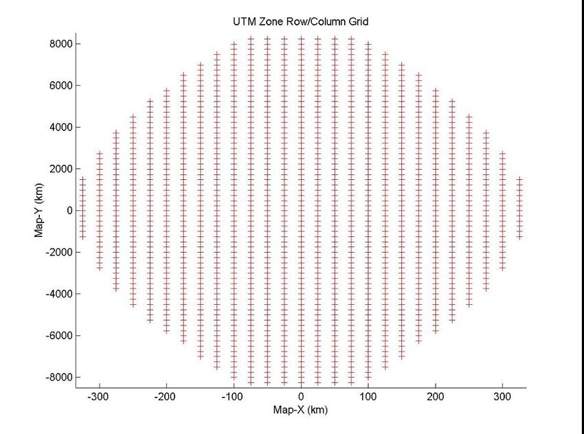
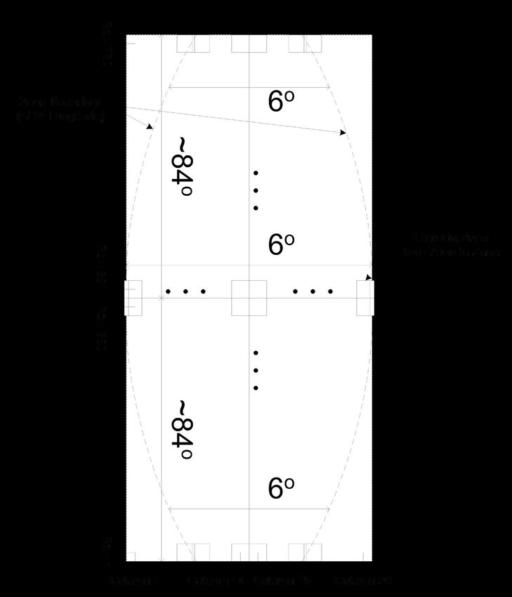
Near-Infrared (NIR)
Near Infrared is a region of the electromagnetic spectrum.

Orthorectification
The process of removing and correcting geometric image distortions introduced by satellite collection geometry,
pointing error, and terrain variability.

Ortho Tile
Ortho Tiles are Planet’s core product lines of high-resolution satellite images. Ortho tiles are available in two different
product formats: Visual and Analytic, each offered in GeoTIFF format.

PlanetScope
The first three generations of Planet’s optical systems are referred to as PlanetScope 0, PlanetScope 1, and PlanetScope 2.

Radiometric Correction
The correction of variations in data that are not caused by the object or image being scanned. These include correction
for relative radiometric response between detectors, filling non-responsive detectors and scanner inconsistencies.

Reflectance Coefficient
The reflectance coefficient provided in the metadata is used as a multiplicative to convert Analytic TOA Radiance values
to TOA Reflectance.

RapidEye
RapidEye refers to the five-satellite constellation in operation since 2009.

Scene
A single image captured by a PlanetScope satellite.

Sensor Correction
The correction of variations in the data that are caused by sensor geometry, attitude and ephemeris.

Sentinel-2
Copernicus Sentinel-2 is a multispectral imaging satellite constellation operated by the European Space Agency.

Sun Azimuth
The angle of the sun as seen by an observer located at the target point, as measured in a clockwise direction from the North.

Sun Elevation
The angle of the sun above the horizon.

Sun Synchronous Orbit (SSO)
A geocentric orbit that combines altitude and inclination in such a way that the satellite passes over any given point
of the planet’s surface at the same local solar time.

Tile Grid System
Ortho tiles are based on a worldwide, fixed UTM grid system. The grid is defined in 24 km by 24 km tile centers, with 1 km
of overlap (each tile has an additional 500 m overlap with adjacent tiles), resulting in 25 km by 25 km tiles.

© Planet Labs Inc 2018                                                                                                        Page 6
1. OVERVIEW OF DOCUMENT

    This document describes Planet satellite imagery products. It is intended for users of satellite imagery interested in working
    with Planet’s product offerings.

    1.1. COMPANY OVERVIEW

    Planet uses an agile aerospace approach for the design of its satellites, mission control and operations systems; and the
    development of its web-based platform for imagery processing and delivery. Planet employs an “always on” image-
    capturing method as opposed to the traditional tasking model used by most satellite companies today.

    1.2. DATA PRODUCT OVERVIEW

    Planet operates the PlanetScope (PS), RapidEye (RE) and SkySat (SS) Earth-imaging constellations. Imagery is collected
    and processed in a variety of formats to serve different use cases, be it mapping, deep learning, disaster response, precision
    agriculture, or simple temporal image analytics to create rich information products.

    PlanetScope satellite imagery is captured as a continuous strip of single frame images known as “scenes.” Scenes may be
    acquired as a single RGB (red, green, blue) frame or a split-frame with a RGB half and a NIR (near-infrared) half depending
    on the capability of the satellite.

    Planet offers three product lines for PlanetScope imagery: a Basic Scene product, an Ortho Scene product, and an Ortho Tile
    product. The Basic Scene product is a scaled Top of Atmosphere Radiance (at sensor) and sensor-corrected product. The Basic
    Scene product is designed for users with advanced image processing and geometric correction capabilities. The product is not
    orthorectified or corrected for terrain distortions. Ortho Scenes represent the single-frame image captures as acquired by a
    PlanetScope satellite with additional post processing applied. Ortho Tiles are multiple orthorectified scenes in a single strip that
    have been merged and then divided according to a defined grid.

    SkySat imagery is captured similar to PlanetScope in a continuous strip of single frame images known as “scenes”, which
    are all acquired in the blue, green, red, nir-infrared, and panchromatic bands. SkySat data is available in two product lines:
    the Basic Scene and Ortho Scene products.

    Figure A: Planet Imagery Product Offerings

                    RapidEye                                                       PlanetScope                                                                             SkySat
                    ~6M km2/day                                                      ~150M km2/day                                                                     50K km2/day

    Basic Scene                   Ortho Tile              Basemaps Basic Scene               Ortho Scene            Ortho Tile               Basic Scene                                  Ortho Scene

         Analytic         Visual           Analytic                     Analytic         Visual      Analytic     Visual   Analytic   Analytic        Panchromatic Visual          Analytic     Panchromatic Pansharpened

B    G    R   RE    NIR   R   G    B   B   G   R RE NIR             B    G   R     NIR   R   G   B   B   G   R NIR R G B   B G R NIR B   G    R NIR       PAN      R   G   B   B    G   R NIR       PAN      B   G   R   NIR

    © Planet Labs Inc 2018                                                                                                                                                                                       Page 7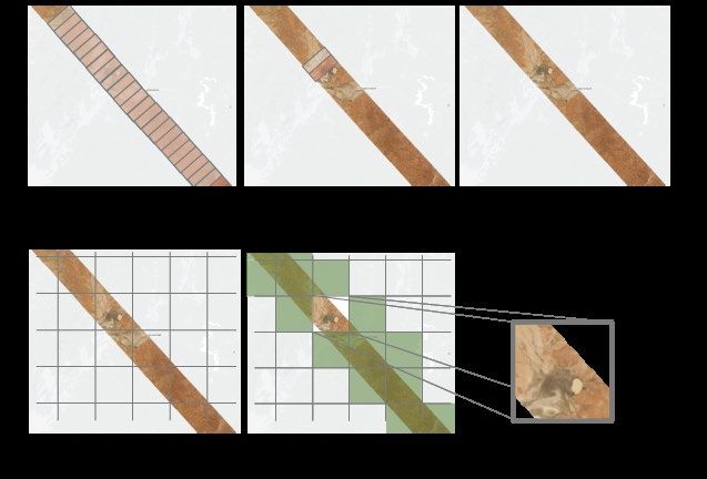
2. S
    ATELLITE CONSTELLATION AND SENSOR OVERVIEW

2.1 PLANETSCOPE SATELLITE CONSTELLATION AND SENSOR CHARACTERISTICS

The PlanetScope satellite constellation consists of multiple launches of groups of individual satellites. Therefore, on-orbit
capacity is constantly improving in capability or quantity, with technology improvements deployed at a rapid pace.

Each PlanetScope satellite is a CubeSat 3U form factor (10 cm by 10 cm by 30 cm). The complete PlanetScope constellation of
approximately 120 satellites will be able to image the entire land surface of the Earth every day (equating to a daily collection
capacity of 150 million km²/day).

Table 2-A: PlanetScope Constellation and Sensor Specifications

CONSTELLATION OVERVIEW: PLANETSCOPE
Mission Characteristics                      International Space Station Orbit               Sun-synchronous Orbit
Orbit Altitude (reference)                   400 km (51.6° inclination)                      475 km (~98° inclination)
Max/Min Latitude Coverage                    ±52° (depending on season)                      ±81.5° (depending on season)
Equator Crossing Time                        Variable                                        9:30 - 11:30 am (local solar time)
Sensor Type                                  Three-band frame Imager or four-band frame Imager with a split-frame NIR filter
Spectral Bands                               Blue                    Green                   Red                     NIR
                                             455 – 515 nm            500 – 590 nm            590 – 670 nm            780 – 860 nm
Ground Sample Distance (nadir)               3.0 m (approximate)                             3.5 m - 4 m depending on flock
Frame Size                                   20 km x 12 km (approximate)                     24.6 km x 16.4 km (approximate)
Maximum Image Strip per orbit                8,100 km²                                       20,000 km²
Revisit Time                                 Variable                                        Daily at nadir (early 2017)
Image Capture Capacity                       Variable                                        340 million km²/day
Camera Dynamic Range                         12-bit                                          12-bit

2.2 RAPIDEYE SATELLITE CONSTELLATION AND SENSOR CHARACTERISTICS

The RapidEye satellite constellation consists of five satellites collectively able to collect over 6 million square kilometers of data
per day at 6.5 meter GSD (at nadir). Each satellite measures less than one cubic meter and weighs 150 kg (bus + payload).
All five satellites are equipped with identical sensors and are located in the same orbital plane.

Table 2-B: RapidEye Constellation and Sensor Specifications

CONSTELLATION OVERVIEW: RAPIDEYE
Mission Characteristic                       Information
Number of Satellites                         5
Orbit Altitude                               630 km in Sun-Synchronous Orbit
Equator Crossing Time                        11:00 am local time (approximately)
Sensor Type                                  Multispectral push broom
Spectral Bands                               Blue              Green              Red                 Red Edge         NIR
                                             440 – 510 nm      520 – 590 nm       630 – 685 nm        690 – 730 nm     760 – 850 nm
Ground Sampling Distance (nadir)             6.5 m
Swath Width                                  77 km
Maximum Image Strip per orbit                Up to 1500 km of image data per orbit
Revisit Time                                 Daily (off-nadir) / 5.5 days (at nadir)
Image Capture Capacity                       > 6 million km²/day
Camera Dynamic Range                         12-bit

© Planet Labs Inc 2018                                                                                                            Page 8
2.3 SKYSAT SATELLITE CONSTELLATION AND SENSOR CHARACTERISTICS
The SkySat-C generation satellite is a high-resolution Earth imaging satellite, first launched in 2016. Five are currently
in orbit, with six more scheduled to launch at the end of 2017. Each satellite is 3-axis stabilized and agile enough to slew
between different targets of interest. Each satellite has four thrusters for orbital control, along with four reaction wheels
and three magnetic torquers for attitude control.
All SkySats contain Cassegrain telescopes with a focal length of 3.6m, with three 5.5 megapixel CMOS imaging detectors
making up the focal plane.
Table 2-C: SkySat Constellation Overview
CONSTELLATION OVERVIEW: SKYSAT
Attribute Value
Mass 110 kg
Dimensions 60 x 60 x 95 cm
Total DeltaV 180 m/s
Onboard Storage 360 GB + 360 GB cold spare storage
RF Communication X-band downlink (payload): variable, up to 580 Mbit/s
X-band downlink (telemetry): 64 Kbit/s
S-band uplink (command): 32 Kbit/s
Design Life ~6 years
Table 2-D: SkySat Pointing
SKYSAT POINTING
Attribute Value
Geolocation Knowledge 30 m CE90 in a 500 km altitude orbit
Agility 2.3 targets (6.6 x 10 km) per minute
Revisit (per satellite) 4 - 5 days
*Reference altitude 500 km
Equatorial Crossing (UTC) 10:30 - Current C-Gen satellites
13:00 - SkySat-1 and SkySat-2
13:30 - Block-2 C-Gen satellites (November 2017)
Table 2-E: SkySat Sensor Specifications
SKYSAT SENSOR SPECIFICATIONS
Product Attribute Description
Image Configurations Multispectral Sensor (Blue, Green, Red, NIR)
Panchromatic Sensor
Product Framing SkySat Satellites have three cameras per satellite, which capture overlapping strips.
Each of these strips contain overlapping scenes. One scene is approximately 2560 x 1080 pixels
Sensor Type CMOS Frame Camera with Panchromatic and Multispectral halves
Spectral Bands Blue Green Red NIR Pan
450 – 515 nm 515 – 595 nm 605 – 695 nm 740 – 900 nm 450 – 900 nm
© Planet Labs Inc 2018 Page 93. PLANETSCOPE IMAGERY PRODUCTS
PlanetScope imagery products are available as either individual Basic Scenes, Ortho Scenes, or Ortho Tile products.
Table 3-A: PlanetScope Satellite Image Product Processing Levels
PLANETSCOPE SATELLITE IMAGE PRODUCT PROCESSING LEVELS
Name Description Product Level
PlanetScope Basic Scene Product Scaled Top of Atmosphere Radiance (at sensor) and sensor Level 1B
corrected product. The Basic Scene product is designed for
users with advanced image processing and geometric correction
capabilities. This product has scene based framing and is not
projected to a cartographic projection. Radiometric and sensor
corrections applied to the data.
PlanetScope Ortho Scene Product Orthorectified, scaled Top of Atmosphere Radiance (at sensor) Level 3B
image product suitable for analytic and visual applications.
This product has scene based framing and projected to a
cartographic projection.
PlanetScope Ortho Tile Product Radiometric and sensor corrections applied to the data. Level 3A
Imagery is orthorectified and projected to a UTM projection.
The name of each acquired PlanetScope image is designed to be unique and allow for easier recognition and sorting of
the imagery. It includes the date and time of capture, as well as the id of the satellite that captured it. The name of each
downloaded image product is composed of the following elements:
___.
3.1 PLANETSCOPE BASIC SCENE PRODUCT SPECIFICATION
The PlanetScope Basic Scene product is a Scaled Top of Atmosphere Radiance (at sensor) and sensor corrected product,
providing imagery as seen from the spacecraft without correction for any geometric distortions inherent in the imaging
process. It has a scene based framing, and is not mapped to a cartographic projection. This product line is available in
GeoTIFF and NITF 2.1 formats.
The PlanetScope Basic Scene product is a multispectral analytic data product from the satellite constellation. This product
has not been processed to remove distortions caused by terrain and allows analysts to derive information products for data
science and analytics.
The Basic Scene product is designed for users with advanced image processing capabilities and a desire to geometrically
correct the product themselves. The imagery data is accompanied by Rational Polynomial Coefficients (RPCs) to enable
orthorectification by the user.
The geometric sensor corrections applied to this product correct for:
• Optical distortions caused by sensor optics
• Co-registration of bands
© Planet Labs Inc 2018 Page 10The table below describes the attributes for the PlanetScope Basic Scene product:
Table 3-B: PlanetScope Analytic Basic Scene Product Attributes
PLANETSCOPE BASIC SCENE PRODUCT ATTRIBUTES
Product Attribute Description
Product Components The PlanetScope Basic Scene product consists of the following file components:
and Format • Image File – GeoTIFF format
• Metadata File – XML format
• Rational Polynomial Coefficients - XML format
• Thumbnail File – GeoTIFF format
• Unusable Data Mask (UDM) File – GeoTIFF format
Information Content
Analytic Bands 3-band natural color (red, green, blue) or 4-band multispectral image (blue, green,
red, near-infrared)
Ground Sample Distance 3.7 m (average at reference altitude 475 km)
Processing
Pixel Size (orthorectified) N/A
Bit Depth Analytic (DN): 12-bit
Analytic (Radiance - W m-2 sr-1 μm-1): 16-bit
Positional Accuracy Less than 10 m RMSE
Radiometric Corrections • Conversion to absolute radiometric values based on calibration coefficients
• Radiometric values scaled by 100 to reduce quantization error
• Calibration coefficients regularly monitored and updated with on-orbit calibration techniques.
Map Projection N/A
3.2 PLANETSCOPE ORTHO SCENES PRODUCT SPECIFICATION
PlanetScope satellites collect imagery as a series of overlapping framed scenes, and these Scene products are not organized
to any particular tiling grid system. The Ortho Scene products enable users to create seamless imagery by stitching together
PlanetScope Ortho Scenes of their choice and clipping it to a tiling grid structure as required.
The PlanetScope Ortho Scene product is orthorectified and the product was designed for a wide variety of applications that
require imagery with an accurate geolocation and cartographic projection. It has been processed to remove distortions caused by
terrain and can be used for cartographic purposes. The Ortho Scenes are delivered as visual (RGB) and analytic products. Ortho
Scenes are radiometrically-, sensor-, and geometrically-corrected products that are projected to a cartographic map projection.
The geometric correction uses fine Digital Elevation Models (DEMs) with a post spacing of between 30 and 90 meters.
Ground Control Points (GCPs) are used in the creation of every image and the accuracy of the product will vary from region
to region based on available GCPs.
© Planet Labs Inc 2018 Page 11The table below describes the attributes for the PlanetScope Ortho Scene product:
Table 3-C: PlanetScope Ortho Scene Product Attributes
PLANETSCOPE ORTHO SCENE PRODUCT ATTRIBUTES
Product Attribute Description
Product Components PlanetScope Ortho Scene product consists of the following file components:
and Format • Image File – GeoTIFF format
• Metadata File – XML format
• Thumbnail File – GeoTIFF format
• Unusable Data Mask (UDM) file – GeoTIFF format
Product Orientation Map North up
Product Framing Scene Based
Pixel Size (orthorectified) 3.125 m
Bit Depth Visual: 8-bit | Analytic (DN): 12-bit
Analytic (Radiance - W m-2 sr-1 μm-1): 16-bit
Product Size Nominal scene size is approximately 24 km by 7 km, but varies by altitude.
Geometric Corrections Sensor-related effects are corrected using sensor telemetry and a sensor model.
Orthorectification uses GCPs and fine DEMs (30 m to 90 m posting).
Horizontal Datum WGS84
Map Projection UTM
Resampling Kernel Cubic Convolution
3.2.1 PLANETSCOPE VISUAL ORTHO SCENE PRODUCT SPECIFICATION
The PlanetScope Visual Ortho Scene product is orthorectified and color-corrected (using a color curve). This correction
attempts to optimize colors as seen by the human eye providing images as they would look if viewed from the perspective
of the satellite. This product has been processed to remove distortions caused by terrain and can be used for cartographic
mapping and visualization purposes. This correction also eliminates the perspective effect on the ground (not on buildings),
restoring the geometry of a vertical shot. Additionally, a correction is made to the sun angle in each image to account for
differences in latitude and time of acquisition.
The Visual Ortho Scene product is optimal for simple and direct use of an image. It is designed and made visually appealing for
a wide variety of applications that require imagery with an accurate geolocation and cartographic projection. The product can
be used and ingested directly into a Geographic Information System.
Table 3-D: PlanetScope Visual Ortho Scene Product Attributes
PLANETSCOPE VISUAL ORTHO SCENE PRODUCT ATTRIBUTES
Product Attribute Description
Information Content
Visual Bands 3-band natural color (red, green, blue)
Ground Sample Distance 3.7 m (average at reference altitude 475 km)
Processing
Pixel Size (orthorectified) 3.125 m
Bit Depth 8-bit
Geometric Corrections Sensor-related effects are corrected using sensor telemetry and a sensor model.
Spacecraft-related effects are corrected using attitude telemetry and best available ephemeris data.
Orthorectified using GCPs and fine DEMs (30 m to 90 m posting) to3.2.2 PLANETSCOPE ANALYTIC ORTHO SCENE PRODUCT SPECIFICATION
The PlanetScope Analytic Ortho Scene product is orthorectified, multispectral data from the satellite constellation. Analytic
products are calibrated multispectral imagery products that have been processed to allow analysts to derive information
products for data science and analytics. This product is designed for a wide variety of applications that require imagery with
an accurate geolocation and cartographic projection. The product has been processed to remove distortions caused by terrain
and can be used for many data science and analytic applications. It eliminates the perspective effect on the ground (not on
buildings), restoring the geometry of a vertical shot. The PlanetScope Analytic Ortho Scene is optimal for value-added image
processing such as land cover classifications. In addition to orthorectification, the imagery has radiometric corrections applied
to correct for any sensor artifacts and transformation to at-sensor radiance.
Table 3-E: PlanetScope Analytic Ortho Scene Product Attributes
PLANETSCOPE ANALYTIC ORTHO SCENE PRODUCT ATTRIBUTES
Product Attribute Description
Information Content
Analytic Bands 3-band multispectral image (red, green, blue)
4-band multispectral image (blue, green, red, near-infrared)
Ground Sample Distance 3.7 m (average at reference altitude 475 km)
Processing
Pixel Size (orthorectified) 3.125 m
Bit Depth Analytic (DN): 12-bit
Analytic (Radiance - W m-2 sr-1 μm-1): 16-bit
Geometric Corrections Sensor-related effects are corrected using sensor telemetry and a sensor model.
Spacecraft-related effects are corrected using attitude telemetry and best available
ephemeris data. Orthorectified using GCPs and fine DEMs (30 m to 90 m posting) to3.3 PLANETSCOPE ORTHO TILE PRODUCT SPECIFICATION
The PlanetScope Ortho Tile products offer PlanetScope Satellite imagery orthorectified as individual 25 km by 25 km tiles
referenced to a fixed, standard image tile grid system. This product was designed for a wide variety of applications that
require imagery with an accurate geolocation and cartographic projection. It has been processed to remove distortions
caused by terrain and can be used for cartographic purposes.
For PlanetScope split-frame satellites, imagery is collected as a series of overlapping framed scenes from a single satellite in a
single pass. These scenes are subsequently orthorectified and an ortho tile is then generated from a collection of consecutive
scenes, typically 4 to 5. The process of conversion of framed scene to ortho tile is outlined in the figure below.
The PlanetScope Ortho Tile products are radiometrically-, sensor-, and geometrically-corrected and aligned to a cartographic
map projection. The geometric correction uses fine DEMs with a post spacing of between 30 and 90 meters. GCPs are used in
the creation of every image and the accuracy of the product will vary from region to region based on available GCPs.
Figure B: PlanetScope Scene to Ortho Tile Conversion
The table below describes the attributes for the PlanetScope Ortho Tile product:
Table 3-F: PlanetScope Ortho Tile Product Attributes
PLANETSCOPE ORTHO TILE PRODUCT ATTRIBUTES
Product Attribute Description
Product Components PlanetScope Ortho Tile product consists of the following file components:
and Format
• Image File – GeoTIFF format
• Metadata File – XML format
• Thumbnail File – GeoTIFF format
• Unusable Data Mask (UDM) File – GeoTIFF format
Product Orientation Map North Up
Product Framing PlanetScope Ortho Tiles are based on a worldwide, fixed UTM grid system.
The grid is defined in 24 km by 24 km tile centers, with 1 km of overlap (each tile has
an additional 500 m overlap with adjacent tiles), resulting in 25 km by 25 km tiles.
© Planet Labs Inc 2018 Page 14PLANETSCOPE ORTHO TILE PRODUCT ATTRIBUTES
Product Attribute Description
Pixel Size (orthorectified) 3.125 m
Bit Depth 16-bit
Product Size Tile size is 25 km (8000 lines) by 25 km (8000 columns). 5 to 500 Mbytes per Tile
for 4 bands at 3.125 m pixel size after orthorectification.
Geometric Corrections Sensor-related effects are corrected using sensor telemetry and a sensor model.
Orthorectified using GCPs and fine DEMs (30 m to 90 m posting).
Horizontal Datum WGS84
Map Projection UTM
Resampling Kernel Cubic Convolution
3.3.1 PLANETSCOPE VISUAL ORTHO TILE PRODUCT SPECIFICATION
The PlanetScope Visual Ortho Tile product is orthorectified and color-corrected (using a color curve). This correction attempts
to optimize colors as seen by the human eye providing images as they would look if viewed from the perspective of the satellite.
It has been processed to remove distortions caused by terrain and can be used for cartographic mapping and visualization
purposes. It eliminates the perspective effect on the ground (not on buildings), restoring the geometry of a vertical shot.
Additionally, a correction is made to the sun angle in each image to account for differences in latitude and time of acquisition.
The Visual product is optimal for simple and direct use of the image. It is designed and made visually appealing for a wide variety
of applications that require imagery with an accurate geolocation and cartographic projection. The product can be used and
ingested directly into a Geographic Information System.
Table 3-G: PlanetScope Visual Ortho Tile Product Attributes
PLANETSCOPE VISUAL ORTHO TILE PRODUCT ATTRIBUTES
Product Attribute Description
Information Content
Visual Bands 3-band natural color (red, green, blue)
Ground Sample Distance 3.7 m (average at reference altitude 475 km)
Processing
Pixel Size (orthorectified) 3.125 m
Bit Depth 8-bit
Geometric Corrections Sensor-related effects are corrected using sensor telemetry and a sensor model, bands are
co-registered, and spacecraft-related effects are corrected using attitude telemetry and best
available ephemeris data. Orthorectified using GCPs and fine DEMs (30 m to 90 m posting)
to < 10 m RMSE positional accuracy.
Positional Accuracy Less than 10 m RMSE
Color Enhancements Enhanced for visual use and corrected for sun angle
© Planet Labs Inc 2018 Page 153.3.2 PLANETSCOPE ANALYTIC ORTHO TILE PRODUCT SPECIFICATION
The PlanetScope Analytic Ortho Tile product is orthorectified, multispectral data from the satellite constellation. Analytic
products are calibrated multispectral imagery products that have been processed to allow analysts to derive information
products for data science and analytics. This product is designed for a wide variety of applications that require imagery with
an accurate geolocation and cartographic projection. It has been processed to remove distortions caused by terrain and can
be used for many data science and analytic applications. It eliminates the perspective effect on the ground (not on buildings),
restoring the geometry of a vertical shot. The orthorectified visual imagery is optimal for value-added image processing
including vegetation indices, land cover classifications, etc. In addition to orthorectification, the imagery has radiometric
corrections applied to correct for any sensor artifacts and transformation to scaled at-sensor radiance.
Figure C: PlanetScope Analytic Ortho Tiles with RGB (left) and NIR False-Color Composite (right)
Table 3-H: PlanetScope Analytic Ortho Tile Product Attributes
PLANETSCOPE ANALYTIC ORTHO TILE PRODUCT ATTRIBUTES
Product Attribute Description
Information Content
Analytic Bands 4-band multispectral image (blue, green, red, near-infrared)
Ground Sample Distance 3.7 m (average at reference altitude 475 km)
Processing
Pixel Size (orthorectified) 3.125 m
Bit Depth Analytic (DN): 12-bit
Analytic (Radiance - W m-2 sr-1 μm-1): 16-bit
Geometric Corrections Sensor-related effects are corrected using sensor telemetry and a sensor model, bands are
co-registered, and spacecraft-related effects are corrected using attitude telemetry and best
available ephemeris data. Orthorectified using GCPs and fine DEMs (30 m to 90 m posting) toFigure D: PlanetScope Analytic Bands
bare sparse/unhealthy dense/healthy
© Planet Labs Inc 2018 Page 174. RAPIDEYE IMAGERY PRODUCTS
RapidEye imagery products are available in two different processing levels to be directly applicable to customer needs.
Table 4-A: RapidEye Satellite Image Product Processing Levels
RAPIDEYE SATELLITE IMAGE PRODUCT PROCESSING LEVELS
Name Description Product Level
RapidEye Basic Scene Product Radiometric and sensor corrections applied to the Level 1B
data. On-board spacecraft attitude and ephemeris
applied to the data.
RapidEye Ortho Tile Product Radiometric and sensor corrections applied to the Level 3A
data. Imagery is orthorectified using the RPCs and
an elevation model.
The name of each acquired RapidEye image is designed to be unique and allow for easier recognition and sorting of
the imagery. It includes the date and time of capture, as well as the id of the satellite that captured it. The name of each
downloaded image product is composed of the following elements:
RapidEye Ortho Tiles:
____.
RapidEye Basic Scenes:
T___.
4.1 RAPIDEYE BASIC SCENE PRODUCT SPECIFICATION
RapidEye Basic product is the least processed of the available RapidEye imagery products. This product is designed for
customers with advanced image processing capabilities and a desire to geometrically correct the product themselves. This
product line will be available in GeoTIFF and NITF formats.
The RapidEye Basic Scene product is radiometrically- and sensor-corrected, providing imagery as seen from the spacecraft
without correction for any geometric distortions inherent in the imaging process, and is not mapped to a cartographic projection.
The imagery data is accompanied by all spacecraft telemetry necessary for the processing of the data into a geo-corrected form,
or when matched with a stereo pair, for the generation of digital elevation data. Resolution of the images is 6.5 meters GSD at
nadir. The images are resampled to a coordinate system defined by an idealized basic camera model for band alignment.
The radiometric corrections applied to this product are:
• Correction of relative differences of the radiometric response between detectors
• Non-responsive detector filling which fills null values from detectors that are no longer responding
• Conversion to absolute radiometric values based on calibration coefficients
The geometric sensor corrections applied to this product correct for:
• Internal detector geometry which combines the two sensor chipsets into a virtual array
• Optical distortions caused by sensor optics
• Registration of all bands together to ensure all bands line up with each other correctly
© Planet Labs Inc 2018 Page 18The table below lists the product attributes for the RapidEye Basic Scene product.
Table 4-B: RapidEye Basic Scene Product Attributes
RAPIDEYE BASIC SCENE PRODUCT ATTRIBUTES
Product Attribute Description
Product Components RapidEye Basic Scene product consists of the following file components:
and Format
• Image File – Image product delivered as a group of single-band NITF or GeoTIFF files
with associated RPC values. Bands are co-registered.
• Metadata File – XML format metadata file and GeoJSON metadata available
• Unusable Data Mask (UDM) File – GeoTIFF format
• S
pacecraft information (SCI) file - XML format and contains additional information related
to spacecraft attitude, spacecraft ephemeris, spacecraft temperature measurements, line
imaging times, camera geometry, and radiometric calibration data.
• Browse Image - GeoTIFF format
Product Orientation Spacecraft/Sensor Orientation
Product Framing
Geographic based framing –
a geographic region is defined
by two corners. The product
width is close to the full image
swath as observed by all bands
(77 km at nadir, subject to minor
trimming of up to 3 km during
processing) with a product
length that does not exceed
300 km with a minimum length
of 50 km and around a 10km
overlap.
Geographic perspective Image perspective
Ground Sample Distance (nadir) 6.5 m
Bit Depth 16-bit unsigned integers
Pixel Size (orthorectified) 6.5m at Nadir
Geometric Corrections Idealized sensor, orbit and attitude models. Bands are co-registered.
Horizontal Datum WGS84
Map Projection N/A
Resampling Kernel Cubic Convolution
© Planet Labs Inc 2018 Page 194.2 RAPIDEYE ORTHO TILE PRODUCT SPECIFICATION
The RapidEye Ortho Tile products offer RapidEye Satellite imagery orthorectified as individual 25 km by 25 km tiles. This
product was designed for a wide variety of applications that require imagery with an accurate geolocation and cartographic
projection. It has been processed to remove distortions caused by terrain and can be used for many cartographic purposes.
The RapidEye Ortho Tile products are radiometrically-, sensor- and geometrically-corrected and aligned to a cartographic map
projection. The geometric correction uses fine DEMs with a post spacing of between 30 and 90 meters. GCPs are used in the
creation of every image and the accuracy of the product will vary from region to region based on available GCPs. RapidEye
Ortho Tile products are output as 25 km by 25 km tiles referenced to a fixed, standard RapidEye image tile grid system.
The table below lists the product attributes for the RapidEye Ortho Tile product.
Table 4-C: RapidEye Ortho Tile Product Attributes
RAPIDEYE ORTHO TILE PRODUCT ATTRIBUTES
Product Attribute Description
Product Components RapidEye Ortho Tile product consists of the following file components:
and Format
• Image File – GeoTIFF file that contains image data and geolocation information
• Metadata File – XML format metadata file and GeoJSON metadata available
• Unusable Data Mask (UDM) File – GeoTIFF format
Product Orientation Map North Up
Product Framing RapidEye Ortho Tiles are based on a worldwide, fixed UTM grid system. The grid is
defined in 24 km by 24 km tile centers, with 1 km of overlap (each tile has an additional
500 m overlap with adjacent tiles), resulting in 25 km by 25 km tiles.
Pixel Size (orthorectified) 5m
Bit Depth Visual: 8-bit
Analytic (Radiance - W m-2 sr-1 μm-1): 16-bit
Product Size Tile size is 25 km (5000 lines) by 25 km (5000 columns). 250 Mbytes per Tile for 5 bands at
5 m pixel size after orthorectification.
Geometric Corrections Sensor-related effects are corrected using sensor telemetry and a sensor model, bands are
co-registered, and spacecraft-related effects are corrected using attitude telemetry and best
available ephemeris data. Orthorectified using GCPs and fine DEMs (30 m to 90 m posting).
Horizontal Datum WGS84
Map Projection UTM
Resampling Kernel Cubic Convolution
4.2.1 RAPIDEYE VISUAL ORTHO TILE PRODUCT SPECIFICATION
The RapidEye Visual Ortho Tile product is orthorectified and color-corrected (using a color curve). This correction attempts to
optimize colors as seen by the human eye providing images as they would look if viewed from the perspective of the satellite.
It has been processed to remove distortions caused by terrain and can be used for cartographic mapping and visualization
purposes. It eliminates the perspective effect on the ground (not on buildings), restoring the geometry of a vertical shot.
Additionally, a correction is made to the sun angle in each image to account for differences in latitude and time of acquisition.
The Visual product is optimal for simple and direct use of the image. It is designed and made visually appealing for a wide
variety of applications that require imagery with an accurate geolocation and cartographic projection. The product can be
used and ingested directly into a Geographic Information System.
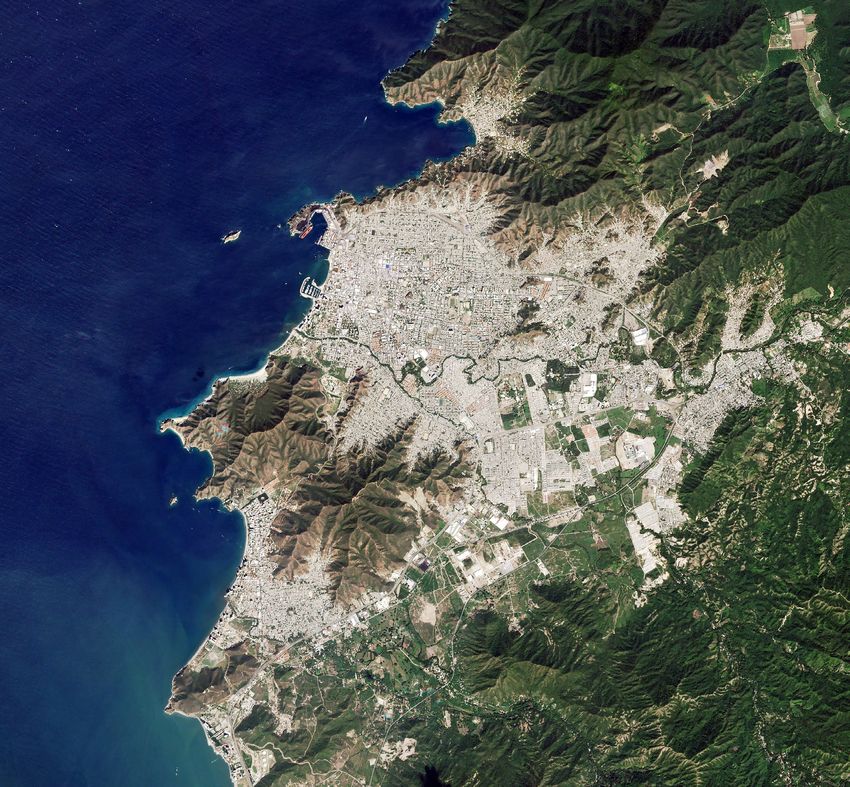
© Planet Labs Inc 2018 Page 20Below is a sample of a RapidEye Visual Ortho Tile:
Figure E: RapidEye Visual Ortho Tile
Table 4-D: RapidEye Visual Ortho Tile Product Attributes
RAPIDEYE VISUAL ORTHO TILE PRODUCT ATTRIBUTES
Product Attribute Description
Information Content
Visual Bands 3-band natural color (red, green, blue)
Ground Sample Distance 6.5 m (at reference altitude 630 km)
Processing
Pixel Size (orthorectified) 5m
Bit Depth 8-bit
Geometric Corrections Sensor-related effects are corrected using sensor telemetry and a sensor model, ban are
co-registered, and spacecraft-related effects are corrected using attitude telemetry and best
available ephemeris data. Orthorectified using GCPs and fine DEMs (30 m to 90 m posting)
to < 10 m RMSE positional accuracy.
Positional Accuracy Less than 10 m RMSE
Radiometric Corrections • Correction of relative differences of the radiometric response between detectors.
• Non-responsive detector filling which fills nulls values from detectors that are no longer responding.
• Conversion to absolute radiometric values based on calibration coefficients.
Color Enhancements Enhanced for visual use and corrected for sun angle
© Planet Labs Inc 2018 Page 214.2.2 RAPIDEYE ANALYTIC ORTHO TILE PRODUCT SPECIFICATION
The RapidEye Analytic Ortho Tile product is orthorectified, multispectral data from the RapidEye satellite constellation.
This product is designed for a wide variety of applications that require imagery with an accurate geolocation and cartographic
projection. It has been processed to remove distortions caused by terrain and can be used for many data science and analytic
applications. It eliminates the perspective effect on the ground (not on buildings), restoring the geometry of a vertical shot.
The orthorectified imagery is optimal for value-added image processing including vegetation indices, land cover classifications,
etc. In addition to orthorectification, the imagery has radiometric corrections applied to correct for any sensor artifacts and
transformation to at-sensor radiance.
Table 4-E: RapidEye Analytic Ortho Tile Product Attributes
RAPIDEYE ANALYTIC ORTHO TILE PRODUCT ATTRIBUTES
Product Attribute Description
Information Content
Analytic Bands 5-band multispectral image (blue, green, red, red edge, near-infrared)
Ground Sample Distance 6.5 m (at reference altitude 630 km)
Processing
Pixel Size (orthorectified) 5m
Bit Depth 16-bit
Geometric Corrections Sensor-related effects are corrected using sensor telemetry and a sensor model, bands are
co-registered, and spacecraft-related effects are corrected using attitude telemetry and best
available ephemeris data. Orthorectified using GCPs and fine DEMs (30 m to 90 m posting)
to < 10 m RMSE positional accuracy.
Positional Accuracy Less than 10 m RMSE
Radiometric Corrections • Correction of relative differences of the radiometric response between detectors.
• Non-responsive detector filling which fills nulls values from detectors that are no longer responding.
• Conversion to absolute radiometric values based on calibration coefficients.
© Planet Labs Inc 2018 Page 225. SKYSAT IMAGERY PRODUCTS
5.1 SKYSAT BASIC SCENE PRODUCT SPECIFICATION
The SkySat Basic Scene product includes Analytic and Panchromatic imagery that is uncalibrated and in a raw digital number
format. The Basic Scene Product is not radiometrically corrected for atmosphere or for any geometric distortions inherent in
the imaging process.
Imagery data is accompanied by Rational Polynomial Coefficients (RPCs) to enable orthorectification by the user. This
product is designed for users with advanced image processing capabilities and a desire to geometrically correct the product
themselves.
The SkySat Basic Scene Product has a sensor-based framing, and is not mapped to a cartographic projection.
Table 5-A: SkySat Basic Scene Product Attributes
SKYSAT BASIC SCENE PRODUCT ATTRIBUTES
Product Attribute Description
Product Components Image File – GeoTIFF format
and Format Metadata File – JSON format
Rational Polynomial Coefficients – Text File
UDM File – GeoTIFF format
Information Content
Image Configurations 4-band Analytic DN Image (Blue, Green, Red, NIR)
1-band Panchromatic DN Image (Pan)
Product Orientation Spacecraft/Sensor Orientation
Product Framing SkySat Satellites have three cameras per satellite, which capture overlapping strips.
Each of these strips contain overlapping scenes. One scene is approximately 3199m x 1349m.
Sensor Type CMOS Frame Camera with Panchromatic and Multispectral halves
Spectral Bands Blue Green Red NIR Pan
450 – 515 nm 515 – 595 nm 605 – 695 nm 740 – 900 nm 450 – 900 nm
Processing Basic Scene v0 (Aug 1, 2017) Basic Scene v1 (Sep 15, 2017)
Product Bit Depth 16-bit Unsigned Integer Multispectral and Panchromatic Imagery (12 bit data depth)
Radiometric Corrections Cross-Sensor Non Uniformity Correction (1%)
Color Balancing across cameras
Geometric Corrections Idealized sensor model and Rational Polynomial Coefficients (RPC)
Bands are co-registered
Horizontal Datum WGS84
Map Projection N/A
Resampling Kernel Resampling of Analytic Data to > 1.0 m GSD Resampling of Analytic Multispectral Data
to > 1.0 m GSD
Ground Sample Distance [SkySat-1, SkySat-2] [SkySat-1, SkySat-2]
Panchromatic: 0.86 m Panchromatic: 0.86 m
Multispectral: 1.0 m Multispectral: 1.0 m
[SkySat-3 - SkySat-7] [SkySat-3 - SkySat-7]
Panchromatic: 0.72 m Panchromatic: 0.72 m
Multispectral: 1.0 m Multispectral: 1.0 m
Geometric Accuracy < 90 m RMSE
© Planet Labs Inc 2018 Page 235.2 SKYSAT ORTHO SCENE PRODUCT SPECIFICATION
The Ortho Scene product enables users to create seamless imagery by stitching together SkySat Ortho Scenes of their choice
and clipping them to a tiling grid structure as required. The SkySat Ortho Scene product is orthorectified and the product was
designed for a wide variety of applications that require imagery with an accurate geolocation and cartographic projection. It
has been processed to remove distortions caused by terrain and can be used for cartographic purposes.
The SkySat Ortho Scene product includes Visual, Analytic, Panchromatic, and Pansharpened Multispectral imagery that is uncalibrated
and in a raw digital number format. The Ortho Scene product is sensor- and geometrically-corrected, and is projected to a cartographic
map projection. The geometric correction uses fine Digital Elevation Models (DEMs) with a post spacing of between 30 and 90 meters.
Ground Control Points (GCPs) are used in the creation of every image and the accuracy of the product will vary from region to
region based on available GCPs.
Table 5-B: SkySat Ortho Scene Attributes
SKYSAT ORTHO SCENE PRODUCT ATTRIBUTES
Product Attribute Description
Product Components Image File – GeoTIFF format
and Format Metadata File – JSON format
UDM File – GeoTIFF format
Information Content
Product Framing Scene Based:
SkySat Satellites have three cameras per satellite, which capture overlapping strips. Each of these
strips contain overlapping scenes. One scene is approximately 3199 m x 1349 m.
Sensor Type CMOS Frame Camera with Panchromatic and Multispectral halves
Spectral Bands Blue Green Red NIR Pan
450 – 515 nm 515 – 595 nm 605 – 695 nm 740 – 900 nm 450 – 900 nm
Processing Ortho Scene v0 (Sep 15, 2017) Ortho Scene v1 (Jun 1, 2018)
Radiometric Corrections No correction applied; pixel values are Digital Number and TOA Reflectance
digital numbers
Geometric Corrections Sensor-related effects are corrected using sensor telemetry and a sensor model.
Orthorectification uses GCPs and fine DEMs (30 m to 90 m posting).
Horizontal Datum WGS84 WGS84
Map Projection UTM UTM
Resampling Kernel Cubic Convolution Cubic Convolution
Geometric Accuracy < 10 m RMSE < 10 m RMSE
5.2.1 SKYSAT VISUAL ORTHO SCENE
The SkySat Visual Ortho Scene product is orthorectified, pansharpened, and color-corrected (using a color curve) 3-band RGB Imagery.
Table 5-C: SkySat Visual Ortho Scene Attribute
SKYSAT VISUAL ORTHO SCENE ATTRIBUTES
Product Attribute Description
Visual Bands Visual: 3-band Pansharpened Image (PS Red, PS Green, PS Blue)
Ground Sample Distance Multispectral: 1.0 m
Panchromatic: 0.72 m
Processing
Pixel Size (Orthorectified) 0.8 m*
Bit Depth 8-bit Unsigned Integer
© Planet Labs Inc 2018 Page 24You can also read