PRELIMINARY EVALUATIONS OF THE NOVEMBER 2021 FLORIDA FOREVER PROPOSALS - Florida Natural Areas Inventory
←
→
Page content transcription
If your browser does not render page correctly, please read the page content below
PRELIMINARY EVALUATIONS
   OF THE NOVEMBER 2021
FLORIDA FOREVER PROPOSALS

             Prepared by

  Florida Natural Areas Inventory
        1018 Thomasville Road
              Suite 200-C
         Tallahassee, FL 32303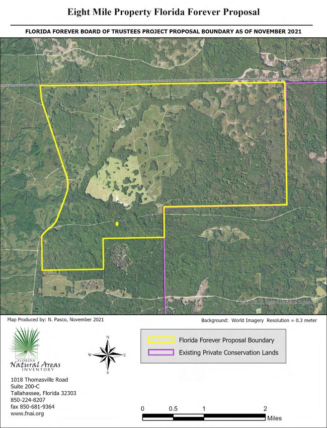
Preliminary Evaluations of the November 2021 Florida Forever Proposals

The Florida Natural Areas Inventory (FNAI) is dedicated to gathering, interpreting, and disseminating
information critical to the conservation of Florida’s biological resources. The Inventory was founded in
1981 as a member of The Nature Conservancy’s international network of natural heritage programs, and
it is now part of Florida State University’s Institute of Science and Public Affairs. Funding for FNAI is
provided through contracts, which currently include work for the Florida Department of Environmental
Protection (DEP), the U. S. Fish and Wildlife Service, Florida Forest Service, Florida Fish and Wildlife
Conservation Commission, and Florida’s Water Management Districts.

FNAI staff builds and maintains a comprehensive statewide database that now includes more than
35,000 occurrences of rare plant and animal species and high-quality natural communities. The
database also contains information on more than 2,000 lands managed wholly or in part for
conservation. This database includes national forests, parks and wildlife refuges; state parks, forests,
aquatic preserves, and wildlife management areas; water management district lands; county and
municipal parks; private preserves; and military installations with substantial natural areas. Boundaries
of state land acquisition projects are also represented.

As part of an agreement with DEP, FNAI provides data and expertise to assist with the multi-step process
of evaluating lands proposed for acquisition through the Florida Forever Program. This document
presents our preliminary review of proposals submitted for the cycle beginning November 2021. This
includes the following proposals: Aucilla Corridor, Bar B Ranch, Charlie Creek, Eight Mile Property,
Foshalee Slough, Johnson Homestead, Lake Sampala Timber and Land, River Property, and South Prong
St. Mary’s River. This review includes the following for the proposals: Biological Conservation Priority
(no longer included; see below); Natural Resource Description; Rare Species on the site; a tabular
evaluation of selected Florida Forever Measures; and maps of the proposed site. Recreational and
archeological values are not considered in this evaluation.

Biological Conservation Priority: In previous years FNAI has summarize our overall preliminary
assessment of the proposals as a “Biological Conservation Priority” for each site. This rank represented
our initial assessment of a proposal's contribution to the protection of significant ecological resources
from a statewide perspective. These ranks reflected the FNAI scientific staff’s best judgment based on
information available at the time of the evaluation. Because further assessment is generally needed to
fully determine the biological importance of a site and many conservation factors may not be simply
summarized, we no longer provide this subjective rank.

Florida Natural Areas Inventory
Preliminary Evaluations of the November 2021 Florida Forever Proposals

Natural Resource Description: The description of the natural resources presented for each proposal is
developed from information provided in the proposal application, the FNAI database, FNAI staff
comments, and aerial photographs. The natural communities listed in this evaluation and the
percentage of the total area that each comprises were derived principally from aerial photographs as
interpreted by FNAI staff and by landcover information from the Water Management Districts. These
data were supplemented by FNAI natural community occurrence data where available. These sources
were also used to determine the extent of disturbed lands that no longer support natural communities
(agriculture areas, developed areas, mines, etc.). Acreages of communities and disturbances are
approximate, but provide a reasonable estimate for this stage of the evaluation process. More precise
landcover information is gathered during the project assessment phase for those proposals selected for
further evaluation.

Acreages of natural communities, particularly mesic and wet flatwoods, may differ from acreages given
in the Florida Forever Measures Evaluation (FFME) evaluation table (described below). The FFME relies
on statewide remotely sensed data where on the ground information is lacking. Using current high
resolution aerial photography, FNAI scientists sometimes identify different acreage of certain landcover
types, for example, pine plantation or flatwoods, than is identified through remotely sensed data.

Rare species on the proposed areas are listed in each evaluation. Species recorded in the FNAI database
and those reported in the application are listed separately in the table. Potential rare species may be
discussed in the evaluation text. FNAI Global and State ranks and Federal and State legal statuses are
given for each species in the table. Rank and statuses provided in the text are listed in the same order
after the scientific species name. A rank/status explanation sheet is included at the end of this
document.

Florida Forever Measures Evaluation: Accompanying each evaluation is a table illustrating to what
extent each proposed site meets 15 Florida Forever performance measures. These 15 measures were
selected because they are resource-based criteria that can be used to set acquisition priorities. For each
measure, we report the acres of the resource found on the proposed site and the percentage of the site
containing the resource. The data in this assessment represent a highly standardized, statewide
perspective of natural resource distributions. More detailed information may be gathered during the
Project Assessment phase for those proposals voted upon for further evaluation. The data used in this
evaluation are described in detail in the Florida Forever Conservation Needs Assessment Summary
Report and Technical Report, available at www.fnai.org.

Maps: This report provides two maps of each proposed site. The first is a small-scale map showing the
proposed site in the context of surrounding conservation lands and land protection projects. The
second map is of larger scale and uses recent aerial imagery that provides a view of the overall
landcover of each site.

Florida Natural Areas Inventory
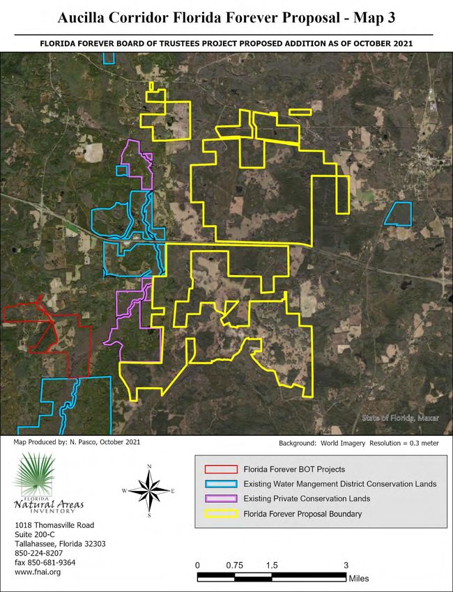
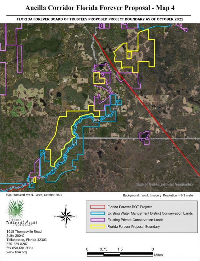
AUCILLA CORRIDOR (JEFFERSON, MADISON, AND TAYLOR COUNTIES)

Less-Than-Fee Simple (14,622 acres); Fee Simple (3,985 acres)

Preliminary Evaluation

Natural Resources Description: The Aucilla Corridor proposal includes several disjunct blocks of land
totaling 18,607 acres (per proposal; 18,608 as determined in GIS) predominantly in Jefferson and
Madison Counties, with one small portion in Taylor County. The property is proposed for a combination
of acquisition and conservation easement. This evaluation is based on information gathered from the
proposal, 1994-2021 aerial photographs, U.S. Geologic Survey (USGS) 7.5’ topographic maps,
Cooperative Land Cover data (Florida Natural Areas Inventory, Florida Cooperative Land Cover Map,
version 3.4), and information in the FNAI database.

Lands included in this proposed project extend approximately 22 miles along the path of the Aucilla
River, beginning near Sneads Smokehouse Lake 5 miles from the Georgia border, and extending south to
the northern edge of Taylor County. In all, the lands included in this project could protect 0.8 miles of
river frontage on the Aucilla itself, an estimated several miles of frontage on multiple tributaries to the
Aucilla, and could protect or buffer extensive areas of wetlands associated with these rivers. The
proposed lands are generally level to gently rolling. Most uplands are cleared or in pine plantation, with
basin swamps, dome swamps, baygalls, and depression marshes interspersed throughout. Lower areas
nearer the streams, and poorly-drained level areas interspersed with the uplands are mostly vegetated
with a combination of hydric hammocks, basin swamps, and some remnant wet flatwoods. The various
lands making up this proposal are described in more detail below.

The northernmost 20 acres of property is on a slight rise above the east edge of the Aucilla floodplain.
This piece of land is situated between 2 noncontiguous blocks of the Upper Aucilla Conservation Area,
one lying 0.6 miles to the north, and the other 0.1 miles south. Across the river to the west, the West
Aucilla Buffer Florida Forever BOT project is 3/4 mile away. This parcel is predominantly forested with a
mix of hydric and mesic hammock.

The largest contiguous block in the proposed project is the Avalon Timberlands tract in Jefferson County,
made up of 8,718 acres north of Lamont, approximately 1 mile west of the Aucilla River. This property
straddles Beasley Creek, which flows from northwest to southeast for 6 miles across the property. In
addition to significant areas of pine plantation, this tract contains extensive forested wetlands
surrounding the creek, including large contiguous areas currently mapped as hydric hammock but which
reportedly include at least some bottomland forest. The Avalon Timberlands tract would contribute
significantly to landscape-scale conservation, as it surrounds the 1018-acre Three Creeks Ranch
Conservation Easement on 3 sides, and is contiguous to the Turkey Scratch Plantation Conservation
Easement, which is in turn connected to several other easements forming a corridor to the Aucilla River
and to the Middle Aucilla Conservation Area. Nearly 9000 acres of additional conservation easements
are 1/3 mile away to the west, and the Econfina Timberlands Florida Forever BOT project adjoins this
property to the east.

Approximately 2 miles west of the Avalon Timberlands tract is a 12-acre property south of the
intersection of US 27 and US 19. This parcel is relatively isolated, lying about 0.4 miles from the Avalon
Plantation Conservation Easement but otherwise not adjoining or close to protected lands. This property
is mostly regenerating from apparent past commercial use, but also contains some wetlands and
flatwoods communities.

Also included in the proposal is a large nearly contiguous area east of the Aucilla River bisected by
Interstate 10 and County Road 150, containing 1.2 miles of frontage on the Aucilla as well as a portion of
the Little Aucilla River. One ownership in this block known as the MWF IV Osceola tract, is located north
of I-10 and is the only land in the project proposed for fee-simple acquisition. This tract is predominantly
pine plantation with various embedded wetland communities, with an extensive area of basin swamp
that appears to have been logged in recent decades.

The land immediately south of I-10, known as the Adams tract, contains several noteworthy natural
features described in the application, including multiple springs, an unusual spring-fed marsh, and
botanically interesting hydric hammock. Although it contains a relatively short distance of river frontage,
the Adams tract parallels the floodplain of the Aucilla for over 2.5 miles, where it shares over 3 miles of
boundary with the Upper Aucilla Conservation Area and the Ragans Conservation Easement.

Approximately 2.3 miles southeast of the Avalon Timberlands tract and 2.5 miles southwest of the
Adams tract is a 1178-acre portion of the project containing wetlands that are part of the headwaters of
an unnamed tributary of the Aucilla River. These lands would close a significant gap along the middle
Aucilla between the Middle Aucilla Conservation Area which lies to the north, and the Lickskillet
Conservation Easement to the south.

The remaining portions of the project are in 3 areas downstream along the Aucilla River: 1,197 acres
along County Road 257 and a separate 123-acres block on the west bank of the river in Jefferson County;
and a 13-acre property bordering the Aucilla in Taylor County. The largest of these is the North Florida
Timber Holdings tract, which parallels the Aucilla River for nearly 4 miles, along which it shares nearly its
entire eastern boundary with the Middle Aucilla Conservation Area.

The majority of the uplands in this proposal have been altered by past or current agricultural or
silvicultural use; pine plantations—either currently planted pine or recently-cleared—make up the
largest land use category in the proposal, with lesser acreages in pasture or other agricultural use.
Prescribed fire is used on some lands, and longleaf pine has been planted in some areas. Although much
of the native groundcover of the original pinelands has likely been impacted by silvicultural activities,
the application indicates that areas of wiregrass and other native groundcover occur on several sites.
Scattered remnant upland natural communities that may be relatively intact occur on several of the
project parcels, including upland pine, upland hardwood forest, mesic hammock, and mesic flatwoods.
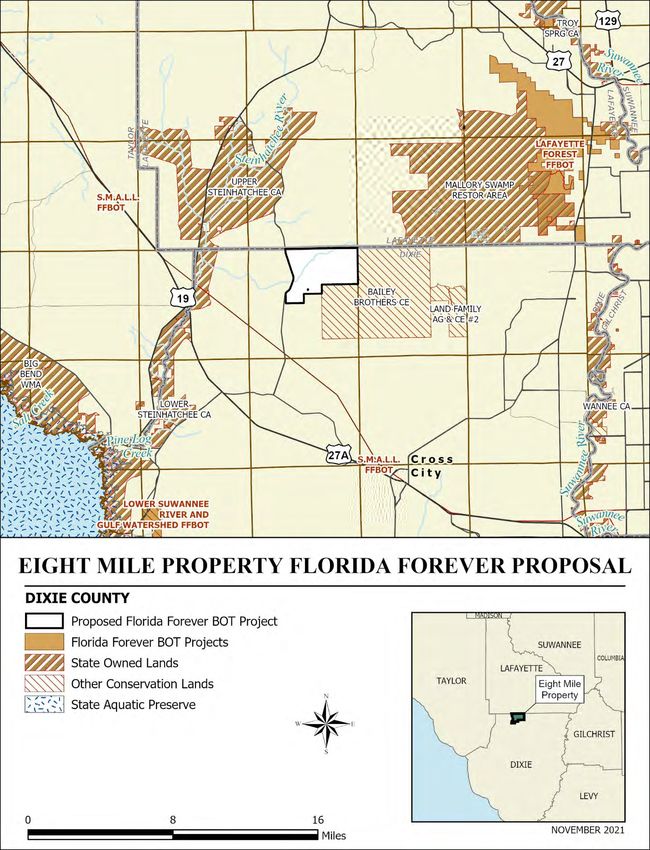
Table 1. Natural communities and landcover types within the Aucilla
Corridor Florida Forever proposal.
         Community or Landcover               Acres         Percent of
                                                             Proposal
 hydric hammock                                   4382               24
 basin swamp                                      3086               17
 wet flatwoods                                     682                4
 dome swamp                                        530                3
 baygall                                           479                3
 depression marsh                                  231                1
 mesic flatwoods                                   215                1
 upland hardwood forest                            177                1
 floodplain swamp                                  123                1
 upland pine                                       120                1
 mesic hammock                                     101                1
 wet prairie                                        97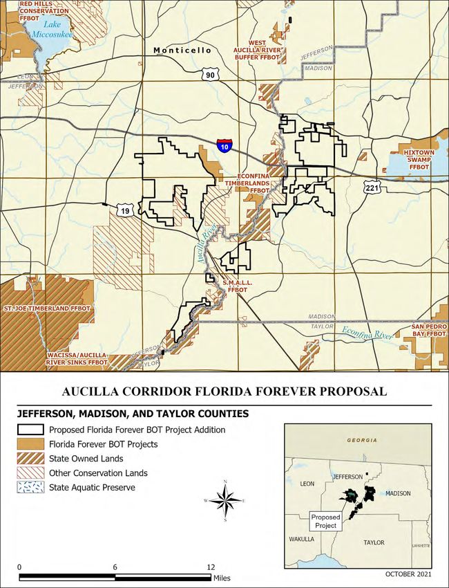
FNAI’s database contains documentation of two rare species, Florida black bear and mud sunfish, within
the proposal area. In addition to these documented species, the application lists a variety of other listed
and rare species that have been observed on the site, including gopher tortoises on or adjacent to
multiple parcels in the proposal area, as well as a variety of species of wading birds, Bachman’s sparrow,
bald eagle, swallow-tailed kite, eastern diamondback rattlesnake, and Seminole crescent. Table 2 lists
the rare plant and animal taxa that have been documented or reported in the project area. In addition
to those listed in Table 2, several rare aquatic and semi-aquatic species have not been documented in
the proposal area but that are found in and around the Aucilla River and its tributaries. It is likely that
some of these species may move through the river system and could therefore use sites within the
proposal area. The presence of springs also suggests that rare cave-dwelling species may occur. Finally,
based on the large acreage of the sites and the lack of detailed surveys, it is possible that additional rare
terrestrial species may occur as well.

Table 2. Rare plants and animals documented or reported to occur within the Aucilla Corridor Florida
Forever proposal.*
 Scientific Name                       Common Name                Global     State    Federal     State
                                                                  Rank       Rank      Status     Status
 Rare plants documented on site
 none
 Additional rare plants reported on
 site by applicant
 Lobelia cardinalis                    cardinalflower               G5        SNR        N          ST
 Rare animals documented on site
 Acantharchus pomotis                  mud sunfish                 G4G5        S3        N          N
 Ursus americanus floridanus           Florida black bear          G5T4        S4        N          N
 Additional rare animals reported on
 site by applicant
 Alligator mississipiensis             American alligator           G5         S4       SAT       ST(S/A)
 Anthanassa texana seminole            Seminole crescent          G5T3T4      S2S3       N           N
 Crotalus adamanteus                   eastern diamondback          G4         S3        N           N
                                       rattlesnake
 Egretta caerulea                      little blue heron            G5         S4        N          ST
 Egretta thula                         snowy egret                  G5         S3        N          N
 Egretta tricolor                      tricolored heron             G5         S4        N          ST
 Elanoides forficatus                  swallow-tailed kite          G5         S2        N          N
 Eudocimus albus                       white ibis                   G5         S4        N          N
 Gopherus polyphemus                   gopher tortoise              G3         S3        C          ST
 Haliaeetus erythrocephalus            bald eagle                   G5         S3        N          N
 Mycteria americana                    wood stork                   G4         S2        T          FT
 Peucaea aestivalis                    Bachman’s sparrow            G3         S3        N          N
*Rank explanations attached.

The Florida Forever Measures Evaluation (FFME) at the end of this memo is based on the Florida Forever
Conservation Needs Assessment developed by FNAI. The data used in that analysis represent a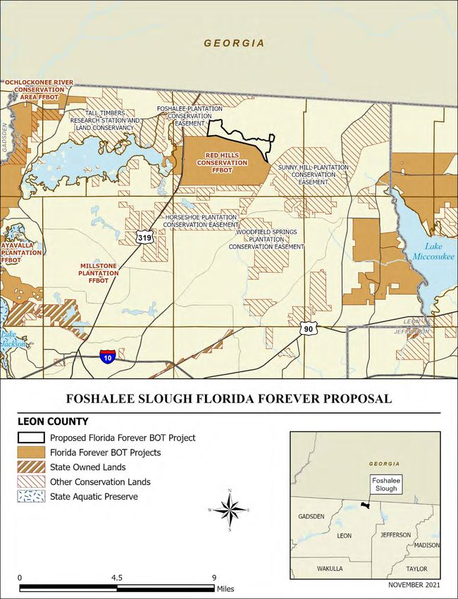
standardized, statewide perspective of natural community distributions based primarily on the
Cooperative Land Cover data (Florida Natural Areas Inventory, Florida Cooperative Land Cover Map,
version 3.4), which explains differences in natural community acreages between Table 1 and the FFME.
Based on this assessment, this project would contribute significantly to several water-related measures,
most notably Natural Floodplain Protection, Surface Water Protection, and Aquifer Recharge. It also
could contribute substantially to protection of Ecological Greenways, Significant Habitat Conservation
Areas, and FNAI Habitat Conservation Priorities.
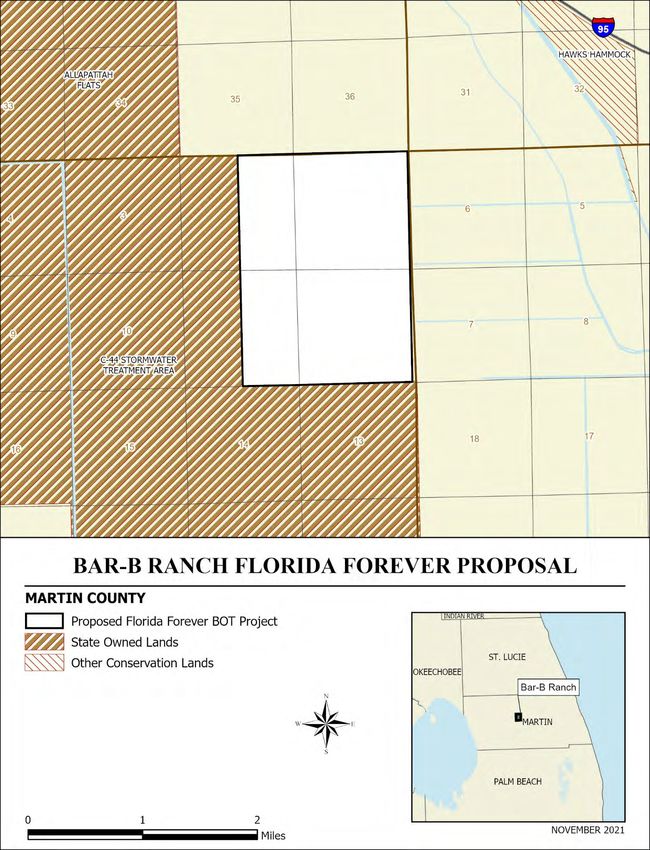
BAR-B RANCH (MARTIN COUNTY)

Fee Simple

Preliminary Evaluation
Natural Resources Description: The Bar-B Ranch proposal comprises 1908 acres (per application; 1910
GIS acres) in central Martin County approximately 10 miles southwest of the city of Stuart and 2 miles
southwest of I-95. The proposed property is adjacent to the northeast boundary of the C-44 Stormwater
Treatment Area which is owned and managed by the South Florida Water Management District
(SFWMD). The Bar-B Ranch proposal is a parcel of interest to SFWMD as a component of the
Comprehensive Everglades Restoration Plan. Allapattah Flats, also owned by SFWMD, is just to the
northwest of the proposal. Hawk’s Hammock (Martin County) is 1.5 miles to the northeast. The nearest
Florida Forever projects are the Pal-Mar projects, about 4 miles to the south, and the Atlantic Ridge
Ecosystem, about 6 miles to the east.

This evaluation is based on information gathered from the proposal application, aerial photography, U.S.
Geologic Survey (USGS) 7.5’ topographic maps, Cooperative Land Cover data (Florida Natural Areas
Inventory [FNAI], Florida Cooperative Land Cover Map, version 3.4), and information in the FNAI
database.

About one third of the property is in natural condition. This is a mesic flatwoods landscape with large
depression or slough marshes and possibly some shorter hydroperiod wet prairies. A small amount of
wet flatwoods may also be present on the property. The proposal is outside of what is believed to be the
historic range of the dry prairie landscape, but the pine flatwoods may be quite similar in nature to that
community with sparse pine canopies and a very low groundcover.

Altered landcover types cover approximately 68% of the proposal. The larger southeast-oriented sloughs
on the property once provided broad surface water drainage across the ranch. According to the
applicant, the installation of a network of ditches in the mid-1900s greatly increased drainage and
allowed the former wetlands to be converted to pasture. Currently, around half of the property is
improved pasture, while another 18% is grazed woodland pasture with some canopy structure or
hammock development. There are also several cattle ponds.

There are several structures on the property at the ranch headquarters, as well as some roads used for
ranch operations. No other improvements are evident. Table 1 provides a list of the landcover types
identified on the proposal and their approximate acreages.
Table 1. Natural communities and landcover types within the Bar-B Ranch
                 Florida Forever proposal
                  Community or Landcover                     Acres          Percent of
                                                                            Proposal
                  mesic flatwoods                                    475               25
                   depression marsh                                                   134                      7
                   wet prairie                                                         10                     1
                   wet flatwoods                                                        8
standardized, statewide perspective of natural community distributions based primarily on the Florida Cooperative Land Cover Map, which explains differences in natural community acreages between Table 1 and the FFME. A high percentage of this proposal contributes to priority 3 and 5 Strategic Habitat Conservation Areas, priorities 4, 5 and 6 FNAI Habitat Conservation Priorities. Nearly 100 percent of the proposal is within priority 2 Ecological Greenways, priority 4 and 6 Surface Water Protection, priority 5 and 6 Aquifer Recharge, and priority 5 Sustainable Forestry.
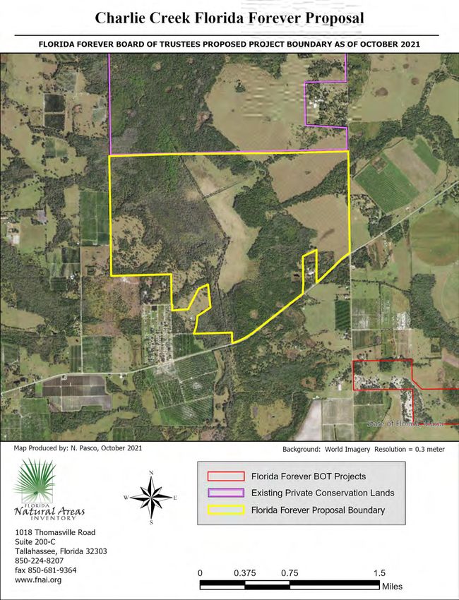
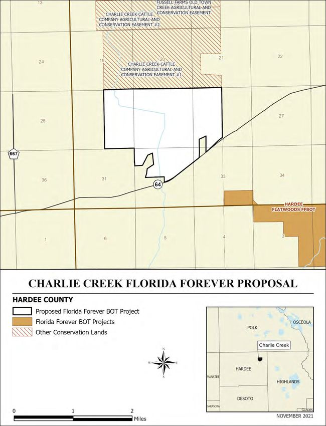
CHARLIE CREEK (HARDEE COUNTY)

Less-Than-Fee Simple

Preliminary Evaluation
Natural Resources Description: The Charlie Creek proposal comprises 1,547.1 acres (per application;
1,533.7 GIS acres) in northeastern Hardee County approximately 3.5 miles west of the Highlands County
line. The southern boundary abuts State Road 64 for ca. 1 mile. The property is rectangular except for an
irregularly shaped southern boundary, extending ca. 2 miles east-west and ca. 1.6 miles north-south at
their widest points. The entire northern boundary is contiguous with Charlie Creek Cattle Company
Agricultural and Conservation Easement #1 (Florida Forest Service, FDACS) which itself is contiguous
with two additional Forest Service Conservation Easements. Further north, Crews Grove Conservation
Easement (Division of State Lands, DEP) touches the northeast corner of the Forest Service Easements
and occupies the northeastern corner of Hardee County. Hardee Flatwoods FFBOT is within a mile to the
south across State Road 64. The proposal is submitted for less-than-fee simple protection.

This evaluation is based on information gathered from the proposal application, aerial photography, U.S.
Geologic Survey (USGS) 7.5’ topographic maps, Cooperative Land Cover data (Florida Natural Areas
Inventory [FNAI], Florida Cooperative Land Cover Map, version 3.4), and information in the FNAI
database.

The proposal contains a channelized, zigzag, portion of Charlie Creek that runs roughly through the
center of the property north to south. Wetland communities make up about 734 acres (48%) of the
proposal; hydric hammock and basin swamp comprise most of the wetlands (44%) along with basin
marsh, depression marsh, dome swamp, and wet prairie (comprising just 2%) and canals/ditches and an
artificial pond 1% of the proposal. Upland communities represent approximately 798 acres or 52% of the
site; improved pasture comprises most of this acreage at about 645 acres (42%). The central, cleared
area (ca. 249 acres referred to as wet prairie in the application) appears to be better described as
pasture that is seasonally grazed by cattle. The remaining 10% includes mesic flatwoods and mesic
hammock natural communities and scattered areas of woodland pasture and successional hardwood
forest.

The pastures on the property were most likely mesic flatwoods before being cleared for cattle, although
the application notes that the central area (designated wet prairie in application) was likely a forested
wetland as seen in 1942 aerial imagery. Elevations range from 60 feet along the Charlie Creek channel to
80 feet in the slough to 80 feet in the uplands at the southwest and northeast corners of the proposal.

The property has been managed as a commercial cow-calf operation for the past 90 years by the family.
No structures are present on the property. Dirt roads mostly follow the ditched channel system. The
mesic flatwoods community is managed with fire every 2-4 years and is allowed to burn into the
hammock edges. Pastures are fertilized once a year and burned every other year in the early spring.
Table 1 provides a list of the landcover types identified on the proposal and their approximate acreages.
Table 1. Natural communities and landcover types within the Charlie Creek
                 Florida Forever proposal.
                  Community or Landcover                        Acres         Percent of
                                                                               Proposal
                   hydric hammock                                                     433                    28
                   basin swamp                                                        249                    16
                   mesic flatwoods                                                      58                     4
                   depression marsh                                                     24                     2
                   mesic hammock                                                        18                     1
                   dome swamp                                                           10                     1
                   basin marsh                                                           2
Table 2. Rare plants and animals documented or reported to occur within the Charlie Creek Florida
Forever proposal.
Scientific Name Common Name Global State Federal State
Rank Rank Status Status
Rare plants documented on site
none
Additional rare plants reported on
site by applicant
none
Rare animals documented on site
Ursus americanus floridanus Florida black bear G5T4 S4 N N
Additional rare animals reported
on site by applicant
Drymarchon couperi eastern indigo snake G3 S3 T FT
Gopherus polyphemus gopher tortoise G3 S3 C ST
Antigone canadensis pratensis Florida sandhill crane G5T2 S2 N ST
Athene cunicularia floridana Florida burrowing owl G4T3 S3 N ST
Sciurus niger niger southeastern fox squirrel G5T5 S3 N N
The Florida Forever Measures Evaluation (FFME) at the end of this memo is based on the Florida Forever
Conservation Needs Assessment developed by FNAI. The data used in that analysis represents a
standardized, statewide perspective of natural community distributions based primarily on the Florida
Cooperative Land Cover Map, which explains differences in natural community acreages between Table
1 and the FFME. This proposal contributes fully to Strategic Habitat Conservation Areas, Ecological
Greenways, Surface Water Protection, and Aquifer Recharge and to a lesser degree but substantially to
FNAI Habitat Conservation Priorities, Natural Floodplain Function, and Functional Wetlands.EIGHT MILE PROPERTY (DIXIE COUNTY) Less-Than-Fee Simple Preliminary Evaluation Natural Resources Description: The Eight Mile Property proposal comprises 5717 acres (per GIS) in north-central Dixie County at its boundary with Lafayette County and approximately 13 miles northeast of the town of Steinhatchee. The proposed property is adjacent to the northwest border of the large Bailey Brothers conservation easement monitored by the Suwannee River Water Management District (SRWMD). The Upper Steinhatchee Conservation Area and Mallory Swamp Restoration Area (both owned by SRWMD) are about 5 miles west and 2.5 miles northeast of the proposal, respectively. Lafayette Forest Wildlife and Environmental Area (Florida Fish and Wildlife Conservation Commission) is approximately 10 miles east-northeast of the Eight Mile Property, adjacent to Mallory Swamp on the east side and part of the Lafayette Forest Florida Forever project. Eight Mile Creek, a tributary of the Suwannee River, begins on the adjacent conservation easement and traverses the proposal westward. Timber production is stated in the proposal as the primary use of the property. This evaluation is based on information gathered from the proposal application, aerial photography, U.S. Geologic Survey (USGS) 7.5’ topographic maps, Cooperative Land Cover data (Florida Natural Areas Inventory [FNAI], Florida Cooperative Land Cover Map, version 3.4), and information in the FNAI database. Landcover on the property is about evenly split between uplands altered for pine timber production and wetlands in relatively natural condition, although forested wetlands on the eastern side of the proposal have been partially cut for cypress. Basin swamp accounts for around 26% of the property and forms a pattern of anastomosing wetlands on the east side of the property as well as a large block in the center. Shorter hydroperiod bottomland forest or hydric hammock may form a mosaic within this central basin. Water collected in these swamps drains north and west into the floodplain swamps associated with Eight Mile Creek. Numerous smaller isolated dome swamps are scattered in pine plantation throughout the property, and baygall communities are likely associated with the basin/floodplain swamp ecotones. All historic upland communities on the Eight Mile Property have been converted to pine plantation. Of these, about 10% appear to have been recently clearcut. A network of small roads, six artificial ponds, and a small sliver of an adjacent developed property make up the remainder of the landcover. No houses are present on the property. Several small structures are evident in a small grassy area identified as developed. Table 1 provides a list of the landcover types identified on the proposal and their approximate acreages.
Table 1. Natural communities and landcover types within the Eight Mile
                 Property Florida Forever proposal.
                  Community or Landcover                        Acres         Percent of
                                                                               Proposal
                  basin swamp                                       1504                26
                  floodplain swamp/bottomland forest                 624                11
                  dome swamp                                         347                 6
                  baygall                                            186                 3
                  wet flatwoods                                         6
Table 2. Rare plants and animals documented or reported to occur within the Eight Mile Property
Forever proposal.
Scientific Name Common Name Global State Federal State
Rank Rank Status Status
Rare plants documented on site
none
Additional rare plants reported on
site by applicant
none
Rare animals documented on site
Ursus americanus floridanus Florida black bear G5T4 S4 N N
Additional rare animals reported
on site by applicant
none
The Florida Forever Measures Evaluation (FFME) on the following page is based on the Florida Forever
Conservation Needs Assessment developed by FNAI. The data used in that analysis represents a
standardized, statewide perspective of natural community distributions based primarily on the Florida
Cooperative Land Cover Map, which explains differences in natural community acreages between Table
1 and the FFME. Most of this proposal contributes to priority 3 and 5 Strategic Habitat Conservation
Areas, priority 2 Ecological Greenways, priority 3 and 4 Natural Floodplain Function, priority 2 to 7
Surface Water Protection, and priority 2 to 5 Aquifer Recharge. About half of the proposal contributes to
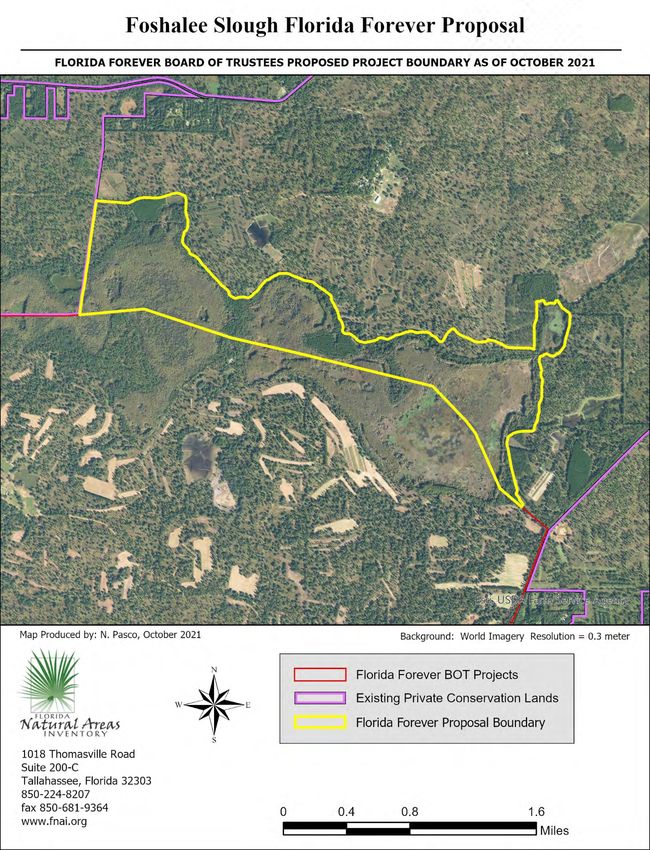
priority 3 and 4 Functional Wetlands.FOSHALEE SLOUGH (LEON COUNTY) Less-Than-Fee Simple Preliminary Evaluation Natural Resources Description: The Foshalee Slough proposal comprises 945 acres (per application; 925 GIS acres) in northern Leon County just south of the Georgia state line. The irregularly shaped tract is elongate, extending ca. 3 miles (5 km) from east to west but only ca. 0.7 mile (1.25 km) from north to south. The entire southern boundary is contiguous with Red Hills Conservation Florida Forever BOT project, and the western boundary borders a 989-acre portion of Foshalee that is already under conservation easement (to Tall Timbers Research Station and Land Conservancy). Additional conservation lands (Sunny Hill and Horseshoe Plantation conservation easements) are contiguous with or very near these units; combined, these lands provide substantial protection to the “Red Hills” region, which encompasses much of northern Leon and Jefferson counties from Lake Miccosukee to Lake Iamonia and the Ochlockonee River. The proposal is submitted for less-than-fee simple protection. This evaluation is based on information gathered from the proposal application, aerial photography, U.S. Geologic Survey (USGS) 7.5’ topographic maps, Cooperative Land Cover data (Florida Natural Areas Inventory [FNAI], Florida Cooperative Land Cover Map, version 2.3), and information in the FNAI database. The proposal principally contains the northern half of Foshalee Slough, the southern half of which lies in the Red Hills Conservation project. This intact and relatively natural slough is a mostly forested depressional wetland that is hydrologically connected (during flood periods) to Lake Iamonia on its west. Wetland communities comprising the portion of the slough within the proposal total ca. 764 acres, or 83% of the proposal; represented communities include basin swamp (bald cypress and tupelo), basin marsh (“Foshalee Lake” in the eastern portion of the slough), and what may best be allocated to bottomland forest (variety of hardwoods). The application notes that the forested wetland communities appear to be second growth, as would be expected for plantation land that has been in use for hundreds of years. A 1.5-acre ephemeral pond near the western boundary represents a depressional marsh within upland pine. Uplands represent about 159 acres (17%) of the property (to as much as 180 acres depending on allocation of some of the bottomland forest noted above); these lie along the site’s northern, western, and eastern edges. Remote analysis recognizes the majority of “natural” uplands (neither cleared nor in plantation) as upland pine, with lesser acreage showing characteristics of sandhill (both are considered under-represented natural communities). These sites are now dominated by loblolly, shortleaf, slash, and longleaf pine. As in most of the Red Hills region, the upland communities grow chiefly on fallowed oldfields that followed more historic agriculture (e.g., cotton plantations); thus, some of the original groundcover components such as wiregrass likely are absent or rare. In the largest section of upland pine in the proposal, a grid of chopped or mowed lanes to aid hunting activities exists within the open-
canopied pinelands. Three small areas (totaling ca. 48 acres) of former upland natural communities, one
in the center of the proposal and two along the northern border in its western half, have been replaced
by pine plantation (in slash and longleaf pines). Elevations range from 100 feet in the slough to 165 feet
in the uplands.

Current uses of Foshalee (in its entirety, not just this proposal) include wildlife management and hunting
(chiefly for northern bobwhite), silviculture (the predominant revenue source), agriculture, and
conservation. There are no developed structures on the proposal other than a small concrete bridge,
and very few roads, mostly accessing the small plantations. Current management includes use of
prescribed fire (allowed to burn into wetlands) and protection of wetlands from logging. It is anticipated
that these uses would continue (dependent on easement terms) under private management. Table 1
provides an approximation of landcover types and their relative representation within the proposal.

               Table 1. Natural communities and landcover types within the Foshalee Slough
               Florida Forever proposal.
                                                              Acres          Percent of
                Community or Landcover
                                                                             Proposal
                Basin swamp                                                             446                    48
                Basin marsh                                                             175                    19
                Bottomland forest                                                       143                    15
                Upland pine/Sandhill                                                    107                    12
                Depression marsh                                                          2
Table 2. Rare plants and animals documented or reported to occur within the Foshalee Slough Florida
Forever proposal.
Scientific Name Common Name Global State Federal State
Rank Rank Status Status
Rare plants documented on site
none
Additional rare plants reported on
site by applicant
none
Rare animals documented on site
none
Additional rare animals reported
on site by applicant
Achalarus lyciades hoary edge G5 S1 N N
Egretta thula snowy egret G5 S3 N N
Eudocimus albus white ibis G5 S4 N N
Mycteria americana wood stork G4 S2 T FT
Parkesia motacilla Louisiana waterthrush G5 S2 N N
Peucaea aestivalis Bachman’s sparrow G3 S3 N N
Sitta carolinensis White-breasted nuthatch G5 S2 N N
Sciurus niger niger southeastern fox squirrel G5T5 S3 N N
The Florida Forever Measures Evaluation (FFME) at the end of this memo is based on the Florida Forever
Conservation Needs Assessment developed by FNAI. The data used in that analysis represents a
standardized, statewide perspective of natural community distributions based primarily on the Florida
Cooperative Land Cover Map, which explains differences in natural community acreages between Table
1 and the FFME. This proposal contributes most notably to Ecological Greenways, Surface Water
Protection, Natural Floodplain Function, Functional Wetlands, and Aquifer Recharge.JOHNSON HOMESTEAD (DESOTO COUNTY) Less-Than-Fee Simple Preliminary Evaluation Natural Resources Description: The Johnson Homestead proposal comprises 702 acres (per application; 703 GIS acres) in central western DeSoto County on the west bank of the Peace River, approximately 6 miles southwest of Arcadia. Its eastern boundary borders the Peace River for 1.5 miles. Across the river, for the full length of the proposal boundary, is the Peace River Preserve Conservation Easement (Division of State Lands, DEP) and a disjunct small piece of the Peace River State Forest that borders the southern boundary of the Easement property. The large expanse of Peace River State Forest lies about a third of a mile to the west of the proposal with natural habitat occurring between them. The complex of Myakka Ranchlands FFBOT project land is roughly 2 miles west of Johnson Homestead property. The proposal is submitted for less-than-fee simple protection. This evaluation is based on information gathered from the proposal application, aerial photography, U.S. Geologic Survey (USGS) 7.5’ topographic maps, Cooperative Land Cover data (Florida Natural Areas Inventory [FNAI], Florida Cooperative Land Cover Map, version 3.4), and information in the FNAI database. Almost 60% of the proposal is within the historical floodplain of the Peace River. Woodland pasture (identified as floodplain swamp in the application), much of it subject to flooding, covers 50% (ca. 352 acres) of the proposal. This community wraps around what looks like a branch to the Peace River in the eastern center of the proposal. This is a manmade logging cut according to the application and is described as an artificial impoundment dominated by exotic wetland plants and open water. Woodland pasture also makes up the northernmost square block of the proposal. These areas include oaks, pines, cabbage palms, and red maple in wetter areas. Another 22% (ca. 152 acres) is comprised of scattered patches of irregularly shaped mesic hammock that occur between basin swamp and pasture areas, within the woodland pasture, and adjacent to the river. Basin swamps (ca. 8% of the proposal) occur as small, forested wetland pockets scattered throughout the center of the site. A small area of floodplain marsh, ca. 9 acres, occurs in the northeastern corner of the property where a historically disturbed streambed drains from Bee Gum Lake, located just off the property to the north. Improved pasture and semi-improved pasture make up about 18% of the property and occur in the northern and western parts of Johnson Homestead. Elevations range from 5 feet along the Peace River to 45 feet in the northern pasture area of the proposal. The property has been managed for cattle according to the application. Mowing is used to enhance grazing over parts of the proposal. Invasive exotic plants, especially wetland species, are abundant. Three block buildings and 2 sheds have been developed on the property in the northwestern section. Several gravel roads are present that access the buildings. Table 1 provides an approximation of landcover types and their relative representation within the proposal.
Table 1. Natural communities and landcover types within the Johnson
                   Homestead Florida Forever proposal.
                    Community or Landcover                      Acres        Percent of
                                                                              Proposal
                    mesic hammock                                    152               22
                    basin swamp                                       53                8
                    floodplain marsh                                  12                2
                    depression marsh                                   5                1

                     woodland pasture                                               352                    50
                     improved pasture                                                88                    12
                     semi-improved pasture                                           40                     6

                     Total                                                          703                   100

The FNAI database contains 1 record for a bald eagle (Haliaetus leucocephalus) nest on the edge of a
hammock in the western part of the site. The last active year was recorded as 2004 (FWC eagle nest
locator). The Florida black bear (Ursus americanus floridanus, G5T4/S4, N, N) is considered occasional
regionally by the FWC 2018 range estimate. The application notes gopher tortoise (Gopherus
polyphemus) as being confirmed on site (Table 2). Other rare species known from the region include an
older record for the rare plant lowland loosestrife (Lythrum flagellare, G2/S2, N, E) that inhabits moist
sandy river banks. Wood stork (Mycteria americana, G4/S2, T, FT) and additional wading birds may also
use the wet pasture areas and other wetlands on the site.
* Rarity rankings in the following order: FNAI (global and state ranks), federal status, state status. Rank explanations attached.

Table 2. Rare plants and animals documented or reported to occur within the Johnson Homestead
Florida Forever proposal.
  Scientific Name                            Common Name                         Global         State      Federal       State
                                                                                 Rank           Rank        Status       Status
 Rare plants documented on site
 none
 Additional rare plants reported on
 site by applicant
 none
 Rare animals documented on site
 Haliaeetus leucocephalus                    bald eagle                            G5            S3           N             N
 Additional rare animals reported
 on site by applicant
 Gopherus polyphemus                         gopher tortoise                       G3            S3           C            ST

The Florida Forever Measures Evaluation (FFME) that follows is based on the Florida Forever
Conservation Needs Assessment developed by FNAI. The data used in that analysis represents a
standardized, statewide perspective of natural community distributions based primarily on the Florida Cooperative Land Cover Map, which explains differences in natural community acreages between Table 1 and the FFME. This proposal contributes 99-100% to Ecological Greenways and Surface Water Protection and to a lesser degree but substantially to Strategic Habitat Conservation Areas, FNAI Habitat Conservation Priorities, Natural Floodplain Function, Functional Wetlands, and Aquifer Recharge.
LAKE SAMPALA TIMBER AND LAND (MADISON COUNTY)

Less-Than-Fee Simple

Preliminary Evaluation
Natural Resources Description: The Lake Sampala Timber and Land proposal comprises 1347 acres (per
application; 1,346 GIS acres) in south-central Madison County approximately 9 miles southwest of the
town of Madison. The proposed property is adjacent to the southern border of two conservation
easements monitored by Florida Forest Service: Koblegard Agricultural and Conservation Easement and
Sampala Lake ARCCO Agricultural and Conservation Easement. These properties as a group are
sandwiched between Hixtown Swamp and Sand Pedro Bay Florida Forever BOT Projects in the upper
reaches of the Econfina watershed near the divide with the Aucilla watershed just a few miles to the
north and west. Timber production is stated in the proposal as the primary use of the property.

This evaluation is based on information gathered from the proposal application, aerial photography, U.S.
Geologic Survey (USGS) 7.5’ topographic maps, Cooperative Land Cover data (Florida Natural Areas
Inventory [FNAI], Florida Cooperative Land Cover Map, version 3.4), and information in the FNAI
database.

Well over half of the proposed property is wetlands in natural condition. Basin swamp accounts for the
vast majority of this, covering approximately 46% of the total area of the property and 72% if the
wetland area in natural condition (excludes successional hydric forest resulting from clearcut basin
swamp). Other wetland communities covering small proportions include shrub bog (10%), basin marsh
(5%), and wet flatwoods. A small swamp lake covering approximately 2 acres is also present.

Altered landcover types cover approximately 37% of the proposed property. This area is dominated by
two types that are approximately equal in areal coverage: pine plantation (17%) and successional hydric
forest (16%). The latter is primarily former basin swamp that has been clearcut or selectively cut
resulting in an early successional wetland community dominated by bay trees and other broadleaf trees
and shrubs. The pine plantation includes former mesic and wet flatwoods. Other altered landcover types
with limited extent are successional hardwood forest (3%), roads (1%), improved pasture (1%), and
clearing (
Table 1. Natural communities and landcover types within the Lake Sampala
                 Timber and Land Florida Forever proposal.
                  Community or Landcover                        Acres         Percent of
                                                                               Proposal
                  basin swamp                                        614                46
                  shrub bog                                          141                10
                  basin marsh                                          69                5
                  wet flatwoods                                        27                2
                  swamp lake                                            2                0

                   pine plantation                                                   227                     17
                   successional hydric forest                                        213                     16
                   successional hardwood forest                                       25                      2
                   road                                                               15                      1
                   improved pasture                                                    9                      1
                   clearing                                                            3                      0
                   developed                                                           1                      0
                   Total                                                            1346                    100

The FNAI database contains no specific records of rare species of animals or plants within the proposed
area. This may reflect lack of biological surveys and the absence of submission of data by others. The
Florida black bear (Ursus americanus floridanus) is considered common in the region of the property by
the FWC 2018 range estimate. The application notes several rare species observed on site (Table 2).
Wading birds are likely to forage in the wetlands on the site.
* Rarity rankings in the following order: FNAI (global and state ranks), federal status, state status. Rank explanations attached.
Table 2. Rare plants and animals documented or reported to occur within the Lake Sampala Timber and
Land Florida Forever proposal.
Scientific Name Common Name Global State Federal State
Rank Rank Status Status
Rare plants documented on site
none
Additional rare plants reported on
site by applicant
none
Rare animals documented on site
Ursus americanus floridanus Florida black bear G5T4 S4 N N
Additional rare animals reported
on site by applicant
Crotalus adamanteus eastern diamondback G4 S3 N N
rattlesnake
Alligator mississippiensis American alligator G5 S4 SAT FT(S/A)
The Florida Forever Measures Evaluation (FFME) on the following page is based on the Florida Forever
Conservation Needs Assessment developed by FNAI. The data used in that analysis represents a
standardized, statewide perspective of natural community distributions based primarily on the Florida
Cooperative Land Cover Map, which explains differences in natural community acreages between Table
1 and the FFME. A high percentage of this proposal contributes to priority 3 and 5 Strategic Habitat
Conservation Areas, priorities 4, 5 and 6 FNAI Habitat Conservation Priorities, and priority 1, 2, and 3
Functional Wetlands. Nearly 100 percent of the proposal is within priority 5 Ecological Greenways,
priority 1, 2 and 3 Natural Floodplain Function, priority 7 Surface Water Protection, and priority 3, 4 and
5 Aquifer Recharge.RIVER PROPERTY (HIGHLANDS COUNTY) Less-Than-Fee Simple Preliminary Evaluation Natural Resources Description: The River Property proposal comprises 3068 acres in eastern Highlands County along a channelized section of the Kissimmee River approximately 10 miles west of the City of Okeechobee 1.5 miles north of State Road 70. The proposed property is adjacent to a west bank sliver of Kissimmee River Water Management Area managed by South Florida Water Management District, which extends northward encompassing a large portion of the former river floodplain corridor up to Lake Kissimmee. Several USDA wetland reserve program easements help fill the gaps in conservation lands along the river in the vicinity of the River Property. The River Property would add to this assemblage, but additional lands would need to be added to complete the corridor south to Lake Okeechobee. This evaluation is based on information gathered from the proposal application, aerial photography, U.S. Geologic Survey (USGS) 7.5’ topographic maps, Cooperative Land Cover data (Florida Natural Areas Inventory [FNAI], Florida Cooperative Land Cover Map, version 3.4), and information in the FNAI database. At least ninety percent of the River Property is improved pasture. Another two percent is semi-improved and woodland pasture. A few remnant, somewhat natural areas include depression marsh, mesic hammock, wet prairie, and slough (old river oxbow); these total approximately five percent of the area and are all encroached or otherwise impacted by the surrounding pasture. There is one house on the property with an adjacent shop/pole barn. There is also a large pole barn/equipment building in one of the improved pastures. No other improvements are evident. Table 1 provides a list of the landcover types identified on the proposal and their approximate acreages. As stated above, River Property is situated in an area of high conservation importance. The site is integral to further restoration of the Kissimmee River and to a planned ecological corridor through the heartland of Florida.
Table 1. Natural communities and landcover types within the River Property
                 Forever proposal.
                  Community or Landcover                        Acres         Percent of
                                                                               Proposal
                  depression marsh                                     66                2
                  mesic hammock                                        60                2
                  wet prairie                                          30                1
                  slough                                                4                0

                   improved pasture                                                 2772                     90
                   ditch/canal                                                        59                      2
                   woodland pasture                                                   45                      1
                   semi-improved pasture                                              24                      1
                   artificial pond                                                     3                      0
                   developed                                                           2                      0
                   road                                                                1                      0
                   Total                                                            3068                    100

The FNAI database contains no specific records of rare species of animals or plants within the proposed
area. This may reflect lack of biological surveys and the absence of submission of data by others. There
is a record for Florida burrowing owl (G4T3, S3, N, ST) adjacent to the property, which may provide
suitable habitat. The application notes several rare species observed on site (Table 2). The proposal also
lists several listed species that potentially would benefit from the protection of this site, including
Florida panther (Puma concolor, coryi; G5T1, S1, E, FE) and Florida bonneted bat (Eumops floridana; G1,
S1, E, FE).
* Rarity rankings in the following order: FNAI (global and state ranks), federal status, state status. Rank explanations attached.
Table 2. Rare plants and animals documented or reported to occur within the River Property Forever
proposal.
Scientific Name Common Name Global State Federal State
Rank Rank Status Status
Rare plants documented on site
none
Additional rare plants reported on
site by applicant
none
Rare animals documented on site
none
Additional rare animals reported
on site by applicant
Alligator mississippiensis American alligator G5 S4 SAT FT(S/A)
Antigone canadensis pratensis Florida sandhill crane G5T2 S2 N ST
Caracara cheriway Crested caracara G5 S2 T FT
Egretta caerulea little blue heron G5 S4 N ST
Egretta thula snowy egret G5 S3 N N
Falco sparverius paulus southeastern American G5T4 S3 N ST
kestrel
Haliaeetus leucocephalus bald eagle G5 S3 N N
Mycteria americana wood stork G4 S2 T FT
The Florida Forever Measures Evaluation (FFME) on the following page is based on the Florida Forever
Conservation Needs Assessment developed by FNAI. The data used in that analysis represents a
standardized, statewide perspective of natural community distributions based primarily on the Florida
Cooperative Land Cover Map, which explains differences in natural community acreages between Table
1 and the FFME. Although a large proportion of the River Property is improved pasture, because of its
location along the Kissimmee River it scores high for several Florida Forever Measures. A high
percentage of this proposal contributes to priority 1 and 3 Strategic Habitat Conservation Areas,
priorities 5 FNAI Habitat Conservation Priorities. The entire property is within priority 1 Ecological
Greenways. Nearly 80% of the site is within priority 4, 5 and 6 Natural Floodplain Function. See the table
on the following page for additional scores for Florida Forever Measures and details.South Prong of the St. Mary’s River (Baker County) Less-Than-Fee Simple Preliminary Evaluation Natural Resources Description: The South Prong of the St. Mary’s River proposal includes 1146 acres (per proposal application; 1147 acres as determined by GIS) in Baker County. The property is proposed by the owner for less-than-fee acquisition. This evaluation is based on information gathered from the proposal, aerial photography from 1994-2021, U.S. Geologic Survey (USGS) 7.5’ topographic maps, Cooperative Land Cover data (Florida Natural Areas Inventory, Florida Cooperative Land Cover Map, version 3.4), and information in the FNAI database. The subject property consists of a single contiguous block of land located in southern Baker County approximately 5 miles south of Sanderson and 3.5 miles south of Interstate 10, fronting County Road 229 along its east boundary for approximately 1 mile. The nearest managed area is Osceola National Forest, approximately 4 miles to the northwest. There are no other Florida managed areas within 10 miles. The property is in a predominantly rural landscape and lies within the Florida Wildlife Corridor, potentially contributing to a connection between Camp Blanding Military Reservation and the Osceola National Forest. The Raiford to Osceola Greenway Florida Forever BOT project lies 1 mile to the west and less than 1 mile to the south, and the Camp Blanding to Raiford Greenway Florida Forever BOT project is approximately 8 miles east. The property consists primarily of plantations of longleaf, slash, and loblolly pine of a variety of ages. It is likely that the site’s history of silviculture under previous owners affected the native plant diversity in the pine plantations, although to what extent is not known; however, the application states that the current owner uses frequent prescribed fire in all pine stands, which should benefit whatever remnant flatwoods flora remains. In addition to pine plantations, natural pine communities also persist in the form of remnant wet flatwoods fringing several of the wetlands, and small blocks of apparently intact mesic flatwoods in several locations. Wildlife management is an important focus of the current owner’s management of the site, and wildlife food plots have been planted throughout the property. This property is about 0.2 miles from the South Prong Saint Marys River. The principal hydrological feature of the property is a basin swamp in the southeastern portion of the property; water drains from this swamp to the northwest through pine plantation before entering another area of swamp that is part of a large wetland complex making up the headwaters and floodplain of the South Prong Saint Marys River. Two other smaller areas of basin swamp on the property contribute to this flow as well. In addition, small dome swamps and depression marshes are scattered through the pine plantation in the upland portions of the property, and wet prairie may be fringing some of the dome and basin swamps.
Table 1. Natural communities and landcover types within the South Prong of
              the St. Mary’s River Florida Forever proposal.
                        Community or Landcover               Acres         Percent of
                                                                            Proposal
               basin swamp                                        200                17
               wet flatwoods                                      150                13
               wet prairie                                         33                 3
               dome swamp                                          26                 2
               mesic flatwoods                                     20                 2
               depression marsh                                     3
Table 2. Rare plants and animals documented or reported to occur within the South Prong of the St.
Marys River Florida Forever proposal. *
Scientific Name Common Name Global State Federal State
Rank Rank Status Status
Rare plants documented on site
none
Additional rare plants reported on
site by applicant
Sarracenia minor hooded pitcherplant G4 S4 N LT
Platanthera chapmanii Chapman’s fringed orchid G2 SNR N LE
Rare animals documented on site
Ursus americanus floridanus Florida Black Bear G5T4 S4 N N
Additional rare animals reported
on site by applicant
Gopherus polyphemus gopher tortoise G3 S3 C LT
Sciurus niger niger G5T5 S3 N N
Dryobates borealis red-cockaded woodpecker G3 S2 E FE
*Rank explanations attached.
The Florida Forever Measures Evaluation (FFME) at the end of this memo is based on the Florida Forever
Conservation Needs Assessment developed by FNAI. The data used in that analysis represents a
standardized, statewide perspective of natural community distributions based primarily on the
Cooperative Land Cover data (Florida Natural Areas Inventory, Florida Cooperative Land Cover Map,
version 3.4), which explains differences in natural community acreages between Table 1 and the FFME.
As summarized in the FFME, this property contributes significantly to surface water protection, aquifer
recharge, and natural floodplain function, and nearly all of the property would contribute to strategic
habitat areas, habitat conservation priorities, and ecological greenways.Elements and Element Occurrences An element is any exemplary or rare component of the natural environment, such as a species, natural community, bird rookery, spring, sinkhole, cave, or other ecological feature. An element occurrence (EO) is an area of land and/or water in which a species or natural community is, or was, present. An EO should have practical conservation value for the Element as evidenced by potential continued (or historical) presence and/or regular recurrence at a given location. Element Ranking and Legal Status Using a ranking system developed by NatureServe and the Natural Heritage Program Network, the Florida Natural Areas Inventory assigns two ranks for each element. The global rank is based on an element's worldwide status; the state rank is based on the status of the element in Florida. Element ranks are based on many factors, the most important ones being estimated number of Element Occurrences (EOs), estimated abundance (number of individuals for species; area for natural communities), geographic range, estimated number of adequately protected EOs, relative threat of destruction, and ecological fragility. FNAI GLOBAL ELEMENT RANK G1 = Critically imperiled globally because of extreme rarity (5 or fewer occurrences or less than 1000 individuals) or because of extreme vulnerability to extinction due to some natural or man-made factor. G2 = Imperiled globally because of rarity (6 to 20 occurrences or less than 3000 individuals) or because of vulnerability to extinction due to some natural or man-made factor. G3 = Either very rare and local throughout its range (21-100 occurrences or less than 10,000 individuals) or found locally in a restricted range or vulnerable to extinction from other factors. G4 = Apparently secure globally (may be rare in parts of range). G5 = Demonstrably secure globally. GH = Of historical occurrence throughout its range, may be rediscovered (e.g., ivory-billed woodpecker). GX = Believed to be extinct throughout range. GXC = Extirpated from the wild but still known from captivity or cultivation. G#? = Tentative rank (e.g., G2?). G#G# = Range of rank; insufficient data to assign specific global rank (e.g., G2G3). G#T# = Rank of a taxonomic subgroup such as a subspecies or variety; the G portion of the rank refers to the entire species and the T portion refers to the specific subgroup; numbers have same definition as above (e.g., G3T1). G#Q = Rank of questionable species - ranked as species but questionable whether it is species or subspecies; numbers have same definition as above (e.g., G2Q). G#T#Q = Same as above, but validity as subspecies or variety is questioned. GU = Unrankable; due to a lack of information no rank or range can be assigned (e.g., GUT2). GNA = Ranking is not applicable because the element is not a suitable target for conservation (e.g. a hybrid species). GNR = Element not yet ranked (temporary). GNRTNR = Neither the element nor the taxonomic subgroup has yet been ranked. FNAI STATE ELEMENT RANK S1 = Critically imperiled in Florida because of extreme rarity (5 or fewer occurrences or less than 1000 individuals) or because of extreme vulnerability to extinction due to some natural or man-made factor. S2 = Imperiled in Florida because of rarity (6 to 20 occurrences or less than 3000 individuals) or because of vulnerability to extinction due to some natural or man-made factor. S3 = Either very rare and local in Florida (21-100 occurrences or less than 10,000 individuals) or found locally in a restricted range or vulnerable to extinction from other factors. S4 = Apparently secure in Florida (may be rare in parts of range). S5 = Demonstrably secure in Florida. SH = Of historical occurrence in Florida, possibly extirpated, but may be rediscovered (e.g., ivory-billed woodpecker). SX = Believed to be extirpated throughout Florida. SU = Unrankable; due to a lack of information no rank or range can be assigned. SNA = State ranking is not applicable because the element is not a suitable target for conservation (e.g. a hybrid species). SNR = Element not yet ranked (temporary).
You can also read