PROJECT DESCRIPTION REPORT - Humboldt County
←
→
Page content transcription
If your browser does not render page correctly, please read the page content below
PROJECT DESCRIPTION REPORT

Project Name:     Humboldt Bay Trail South
Location:         Eureka Waterfront Trail to the southern terminus of the existing
                  Humboldt Bay Trail North
Overview:         A proposed 4.25-mile Class I bikepath (multi-use trail) along the
                  Eureka-Arcata railroad and Highway 101 transportation corridor

                 Humboldt County Department of Public Works
                 1106 Second Street
                 Eureka, CA 95501
                 (707) 445-7741
                 https://humboldtgov.org/HumboldtBayTrail

                 D a t e : SEPTEMBER 9, 2020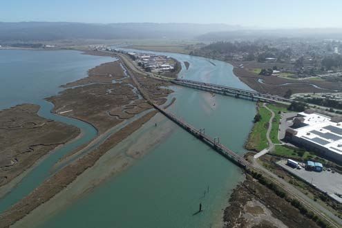
Humboldt Bay Trail South Project
                                                                                                        Project Description Report

                                                   Table of Contents
1   Introduction ............................................................................................................................. 1
    1.1     Summary ...................................................................................................................... 1
    1.2     Location ....................................................................................................................... 4
    1.3     Purpose and Need ........................................................................................................ 5
    1.4     Existing Facilities and Land Use within the Project Area ........................................... 6
    1.5     Eucalyptus Trees .......................................................................................................... 8
    1.6     Flooding Hazards and Sea Level Rise ....................................................................... 10
2   Background and Project History ......................................................................................... 13
    2.1     Regional and Local Planning ..................................................................................... 13
    2.2     Eureka-Arcata Route 101 Corridor Improvement Project ......................................... 17
    2.3     Great Redwood Trail ................................................................................................. 18
3   Project Description ............................................................................................................... 19
    3.1     Overview.................................................................................................................... 19
    3.2     Property and Right-of-Way........................................................................................ 20
    3.3     Design Approach ....................................................................................................... 22
    3.4     Design Discussion by Section.................................................................................... 26
    3.5     Minimum Trail and Railroad Elevations ................................................................... 32
    3.6     Considerations for Future Modifications to Highway 101 ........................................ 35
4   Construction Activities ......................................................................................................... 36
    4.1     Construction Schedule ............................................................................................... 36
    4.2     Project Phasing .......................................................................................................... 36
    4.3     Construction Staging, Activities, and Equipment ...................................................... 36
    4.4     Construction Access and Hauling Traffic .................................................................. 37
    4.5     Traffic Control Plan ................................................................................................... 37
    4.6     Groundwater Dewatering ........................................................................................... 37
    4.7     Eucalyptus Tree Removal .......................................................................................... 38
    4.8     Bridge Construction ................................................................................................... 38
    4.9     Site Restoration and Demobilization ......................................................................... 38
    4.10    Air Quality Construction Control Measures .............................................................. 38
5   Mitigation Measures and Environmental Commitment Conditions ................................ 40
6   Permits and Approvals ......................................................................................................... 44
7   Alternatives............................................................................................................................ 46
8   References .............................................................................................................................. 49

September 9, 2020                                                     i
Humboldt Bay Trail South Project
                                                                     Project Description Report

Figures

1       Vicinity and Existing Conditions Map

2       Humboldt Bay Trail Projects Overview

3       Proposed Trail Alignment and Key Components

4       Planning Area for Humboldt Bay/Eureka Slough Sea Level Rise Adaptation Plan

Attachments

1       60% Design Plans

2       Photographs

3       Environmental Commitment Record

4       Mitigation Monitoring and Reporting Plan

5       Humboldt County Board of Supervisors Resolution 18-79

6       CEQA Comment Evaluation Memo (July 18, 2018)

7       Tree Risk Assessment Report (October 8, 2018)

8       Bird Use Monitoring Report (June 3, 2020)

9       Hazard Scenario Figures (June 30, 2020)

10      Draft Memorandum of Understanding between Humboldt County and Caltrans regarding
        Wetland Mitigation

September 9, 2020                              ii
Humboldt Bay Trail South Project
                                                                           Project Description Report

1       INTRODUCTION
1.1 Summary
This report provides the project description for the Humboldt Bay Trail South Project (“Bay Trail
South Project,” or “Project”) which would expand the Humboldt Bay Trail by 4.25 miles and
complete the trail connection between Eureka and Arcata (Figure 1). The Project is being
developed by the Public Works Department of Humboldt County (“County”). This report is
associated with the 60% design plans (Attachment 1) and will accompany applications for
permits and agreements. Photographs of the Project area are provided in Attachment 2.

The Humboldt Bay Trail is a network of multi-use trails (also known as shared-use paths)
providing non-motorized access for transportation and recreational use throughout the Humboldt
Bay region (Figure 2). The Humboldt Bay Trail will link communities with multi-modal
transportation facilities and connect people to the bay by enabling people of all ages and abilities
to access and experience the bay’s resources up-close. In addition to serving the region’s
transportation needs and enhancing coastal access, the Humboldt Bay Trail will achieve a critical
link in the California Coastal Trail and advance the mandate of Senate Bill SB 1029 for utilizing
the North Coast Railroad Authority (“NCRA”) property and right-of-way to create the Great
Redwood Trail. The overall Humboldt Bay Trail is being developed as a collaborative effort
between the County of Humboldt, Humboldt County Association of Governments (“HCAOG”),
City of Arcata, City of Eureka, California Department of Transportation (“Caltrans”), California
State Coastal Conservancy, NCRA, Humboldt Trails Council, Redwood Community Action
Agency (“RCAA”), Timber Heritage Association (“THA”), and other partners.

In 2018, the City of Arcata completed the Humboldt Bay Trail North segment, which extends
south from Arcata along the Highway 101 and railroad corridor to a terminus located near
Bayside Cutoff and Bracut Industrial Park. Also in 2018, the City of Eureka completed the
Eureka Waterfront Trail, a portion of which extends along the west side of Eureka Slough. The
Bay Trail South Project would connect the Eureka Waterfront Trail to the Humboldt Bay Trail
North segment, thus providing the interconnecting link between the two previously completed
trail projects. The Project is situated primarily along the Highway 101 and railroad corridor, with
the exception of a proposed levee trail segment around the Brainard mill site owned by California
Redwood Company (“CRC”). The Project is being developed concurrent with the Caltrans
Eureka-Arcata Highway 101 Corridor Improvement Project (see Section 2.2).

The Project would result in a continuous, non-motorized trail from central Arcata to the southern
end of Eureka, for a total length of nearly 14 miles. Completion of the link between the two
largest cities in Humboldt County would provide a major step toward regional trail connectivity
around Humboldt Bay. In recent years, the Project has been Humboldt County’s top priority for
investing in active transportation and represents the greatest opportunity to enable a major mode
shift in transportation within the county. The Project is expected to significantly increase the
number of non-motorized trips, improve safety, enhance public health, and promote community
vitality (Section 1.3).

In 2012, the County and NCRA initiated community dialogue regarding the future use of the
railroad corridor around Humboldt Bay through a series of meetings and technical studies,
resulting in consensus on a rails-with-trails approach and a commitment from NCRA to support
trail projects (see Section 2.1). In 2013, the County initiated a technical study to identify

September 9, 2020                                1
Humboldt Bay Trail South Project
Project Description Report
constraints and evaluate potential alignment options for the Project (GHD, April 2014). The
primary constraints influencing the planning and design of the Project include:
• Limited available space
• Proximity to sensitive resources
• Need for compatibility with Highway 101, the NCRA railroad, and private property
• Crossing Eureka Slough
• Mature stand of Eucalyptus trees in physiological decline
• Potential for flooding and erosion along the Humboldt Bay shoreline
In 2015, HCAOG programmed a total of $2 million in regional State Transportation Improvement
Program funds for engineering, environmental studies, and design. The County has
supplemented this budget with approximately $50,000 of County funds to date. Preliminary
engineering and environmental studies are listed on Table 1.1.
Caltrans served as the lead agency for compliance with the National Environmental Policy Act
("NEPA") on behalf of the Federal Highway Administration. Based on the results of the
environmental studies, Caltrans concluded that the Project would have no significant impacts on
the environment as defined by NEPA. Caltrans executed the Categorical Exclusion determination
form for the Project on July 16, 2018. The Environmental Commitment Record associated with
the Categorical Exclusion is provided in Attachment 3.
Humboldt County served as the lead agency for compliance with the California Environmental
Quality Act ("CEQA"). The County prepared an Initial Study to identify potentially significant
environmental impacts associated with the Project. The Initial Study identified eleven mitigation
measures that would collectively reduce environmental impacts to less-than-significant levels
(Attachment 4). These mitigation measures are discussed further in Section 5. On July 31,
2018, the Humboldt County Board of Supervisors adopted the Initial Study and Mitigated
Negative Declaration of environmental impacts for the Project through Resolution 18-79
(Attachment 5). The Comment Evaluation Form responding to comments received during the
public comment period is provided in Attachment 6.
HCAOG initially programmed a total of $2 million in regional transportation funds for the right-
of-way phase of the Eureka-Arcata Highway 101 Corridor Improvement Project. HCAOG and
Caltrans approved transferring these funds to the County for the Bay Trail South Project in 2018,
and the California Transportation Commission (“CTC”) approved this fund transfer in October
2019.
In January 2019, the CTC awarded construction funding ($13.3 million) for the Bay Trail South
Project through the Active Transportation Program. Caltrans has committed additional funding
of $1.25 million and the State Coastal Conservancy has committed additional funding of $2
million for construction.
The County is currently working through the right-of-way and final design phases of the Project.
The target schedule is summarized on Table 1.2.
September 9, 2020 2Humboldt Bay Trail South Project
Project Description Report
Table 1.1 Engineering and Environmental Studies
Project Study Report (Humboldt County, March 2014)
Initial Engineering Study (GHD, August 2014)
Basis of Design Report for Trail Width (Humboldt County, March 2016)
Preliminary Environmental Study (Humboldt County, July 2017)
Vegetation Mapping/Environmentally Sensitive Habitat Areas Screening (GHD,
November 2017a)
Initial Site Assessment (GHD, November 2017b)
Technical Memorandum: Botanical Survey (GHD, December 2017a)
Wetland Delineation (GHD, December 2017b)
Archaeological Survey Report (Roscoe and Associates, February 2018)
Biological Assessment (Caltrans, February 2018)
2018 Bridge Detailed Inspection Report: Eureka Slough Bridge (American Rail
Engineers, February 2018)
Natural Environment Study (Caltrans, March 2018a)
Visual Resources Impact Assessment (GHD, March 2018b)
Location Hydraulic Study (GHD, March 2018a)
Summary Floodplain Encroachment Report (GHD, March 2018b)
Eureka Slough North Coast Railroad Authority Railroad Bridge Improvement
Alternatives Study (Morrison Structures, April 2018)
Sea Level Rise Vulnerability and Adaptation Report (ESA, July 2018)
Technical Memorandum: HBTS Structural Design Criteria for Final Design (Draft)
(Morrison Structures, August 2018)
Historic Property Survey Report (JRP Historical Consulting, April 2018)
Historical Resources Evaluation Report (JRP Historical Consulting, April 2018)
Limited Visual Tree Risk Assessment (Dryad, October 2018)
Geotechnical Report (Crawford and Associates, June 2019)
Bird Use Monitoring Report for Eucalyptus Trees along the Eureka-Arcata Highway
101 Corridor (Sean McAllister, June 2020)
Corridor Sampling Report (GHD, August 2020)
September 9, 2020 3Humboldt Bay Trail South Project
Project Description Report
Table 1.2 Target Timeline
Milestone Date
Complete right-of-way acquisitions March 2021
Receive all permits approvals April 2021
Complete final design and bid package May 2021
Allocation of construction funds by CTC June 2021
Award construction contract August 2021
Begin construction September 2021
Complete construction October 2022
1.2 Location
The Bay Trail South Project is located along the Highway 101 and railroad transportation corridor
between Eureka Slough and Brainard Slough, for a total length of approximately 4.25 miles, with
a portion proposed on the perimeter levee between the Brainard mill site property and Humboldt
Bay (Figure 3). The Project would connect the existing Eureka Waterfront Trail located within
the City of Eureka and the southern terminus of the Humboldt Bay Trail North facility located
south of the City of Arcata. The proposed trail alignment is generally situated between Highway
101 and the railroad prism, except where the proposed alignment is located on the Brainard levee
or where the trail is on the NCRA Eureka Slough Bridge and approaches. Where the Bay Trail
South Project is situated between Highway 101 and the railroad, the proposed alignment is on the
west-northwest side of Highway 101 and on the east-southeast side of the NCRA railroad
corridor. The Bay Trail South Project also includes cable barrier fencing at various locations
along Highway 101 from Eureka Slough to Gannon Slough. Geographic coordinates for the
southern and northern extent of the Project are provided in Table 1.3.
Table 1.3 Project Extent
Location Latitude Longitude
Southern-most point of the trail 40.806793°N -124.14850°W
Northern most point of the trail 40.831808°N -124.082584°W
Southern-most point of cable barrier fence 40.805923°N -124.136041°W
Northern-most point of cable barrier fence 40.846125°N -124.082180°W
September 9, 2020 4Humboldt Bay Trail South Project
Project Description Report
1.3 Purpose and Need
A dedicated bicycle and pedestrian trail between Eureka and Arcata has been a regional priority
for nearly 20 years and is identified as a priority project in the Regional Transportation Plan
(HCAOG, 2017). The Bay Trail South Project will close the existing 4.25-mile gap in the
Humboldt Bay Trail between Eureka and Arcata. The primary purpose of the Project is to
improve safety and connectivity for non-motorized and motorized travelers between Eureka and
Arcata and enhance public access to Humboldt Bay. A separated non-motorized path is needed
because Highway 101 between Eureka and Arcata is an incomplete transportation facility that
was designed primarily to support motorized vehicles and does not provide safe mobility for all
users. Under existing conditions, people seeking to walk or bike between Eureka and Arcata
must travel in the shoulder along a four-lane expressway. The lack of bicycle and pedestrian
facilities is a deterrent for pedestrian and bicycle use and severely limits the number of non-
motorized trips along the highway corridor due to safety concerns. The Project would reduce the
potential for conflicts between bicyclists, pedestrians, and vehicles within the Highway 101
corridor and increase mobility options between the communities of Arcata and Eureka. Trail
users would range in ages, experience levels, and abilities. Trip purposes would include
commuting (to work, school, social events, commerce) and recreation (exercise, enjoyment,
nature study). Modes of mobility would include travel by foot and use of bicycles (upright,
recumbent, three-wheeled), roller skates, skateboards, scooters, strollers, wheelchairs, and other
mobility devices.
Completion of the Project would have multiple benefits, including:
Improved safety – The Project would improve public safety by separating motorized and
non-motorized travelers.
Coastal access and opportunities for nature study – The Project would provide access
to areas of Humboldt Bay that currently have no facilities for public access.
Economic development – The Project would enhance transportation mobility for
workers and provide a major destination for regional tourism.
Congestion relief – The Project would help alleviate vehicular traffic on Highway 101
by providing a non-motorized travel option.
Enhanced quality of life – The Project would provide a new, major facility for active
transportation and outdoor recreation in the Humboldt Bay region.
Improved public health – The Project would create opportunities for increased physical
activity.
Community connectivity – The Project would enhance the link between the two largest
cities in Humboldt County which are currently separated by highways designed
exclusively for vehicles.
Environmental benefits – The Project would result in a reduction in vehicle miles
traveled, fuel consumption, and emissions of greenhouse gases and other combustion
byproducts.
Railroad damage repair and flood risk reduction – The Project would make urgent
repairs of portions of the railroad prism that have been damaged by erosion and which, if
left unrepaired, pose a significant vulnerability to future flood damage and interruption of
Highway 101.
September 9, 2020 5Humboldt Bay Trail South Project
Project Description Report
Filling the gap in the Humboldt Bay Trail between Eureka and Arcata will transform the
transportation corridor by separating pedestrians and cyclists from motorists on Highway 101 and
eliminating a major barrier to active transportation between the two largest population centers in
Humboldt County. The Project would enable a major mode shift toward active transportation for
regular travelers between Eureka and Arcata and create an opportunity for an outstanding
recreational experience along the coast. The completed Humboldt Bay Trail will be a major
destination for residents and visitors seeking to be physically active along a 14-mile continuous
trail while enjoying the scenic beauty of Humboldt Bay. Currently there are no public access
facilities along the Humboldt Bay shoreline between the southern terminus of Arcata’s Humboldt
Bay Trail North and the Eureka Waterfront Trail near Eureka Slough.
1.4 Existing Facilities and Land Use within the Project Area
The Project area and vicinity include Highway 101, railroad lines, and private property. Right-of-
way for the Project is discussed in Section 3.2.
Highway 101
U.S. Highway 101 is the only U.S. highway in Humboldt County and spans the county in the
north-south direction. Highway 101 is classified as a Principal Arterial within Humboldt County
and an Interregional Road System route. Highway 101 provides one of three routes around
northern Humboldt Bay, along with State Route 255 through Manila to the west and Myrtle
Avenue/Old Arcata Road to the east. The segment of Highway 101 between Eureka and Arcata
has the highest highway traffic volume within Humboldt County with an average annual daily
traffic of 36,300 (2011 data). In 2002, this highway segment was designated the Eureka-Arcata
Route 101 Safety Corridor as part of a program to reduce collision rates at the at-grade
intersections, and HCAOG and Caltrans initiated efforts for road improvements to improve safety
and highway operations (Section 2.2). Within the Project area, Highway 101 is a four-lane
expressway with two travel lanes in each direction (south-bound and north-bound) separated by a
vegetated drainage ditch. The roadway includes 11- to 12-foot wide travel lanes and ten-foot
wide shoulders. The posted speed limit is 65 miles per hour north of Bayside Cutoff, and 50
miles per hour south of Bayside Cutoff. Highway 101 crosses Eureka Slough with two parallel
bridges.
Railroad
The railroad around Humboldt Bay is part of the Northwest Pacific Railroad (“NWP”) line which
has been owned and managed by the NCRA since 1992. The track embankment was constructed
starting in 1900 along the margin of the bay. In 1998, commercial railroad operations ceased
under order of the Federal Railroad Administration following severe storm damage on the line
within the Eel River canyon. Track and infrastructure damage on portions of the line in northern
Mendocino and southern Humboldt counties has isolated the northern portion of the line from the
rest of the NCRA track system. Funds have not been available for maintenance on the northern
portion of the NWP line since railroad operations were discontinued. Portions of the line have
deteriorated with embankment erosion, culvert failures, tie deterioration, and vegetation growth
(Willdan/HNTB, 2002; AndersonPenna Partners, 2012).
Within the Project Area, NCRA’s right-of-way is a mix of fee title ownership and easements for
railroad purposes (Section 3.2).
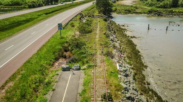
The railroad crosses Eureka Slough with an approximately 17-foot wide, 725-foot long bridge
composed of concrete box girder spans and a steel hydraulic lift section, supported on concrete
pilings (AndersonPenna Partners, October 2012; American Railroad Engineers, February 2018).
September 9, 2020 6Humboldt Bay Trail South Project
Project Description Report
The bridge is currently unused for rail service. If rail service were to resume, significant
maintenance and/or improvements would be required because the condition of portions of the rail
corridor approaching the bridge do not meet current standards for rail traffic. The Eureka Slough
railroad bridge is currently used by the THA for speeder rides.
The approximately 1.25-mile length of railroad prism between Brainard and Bracut has been
severely damaged by erosion. In some areas, the existing rock-slope protection is intact and
stable. However, in many areas the rock-slope protection is absent or composed of disarrayed
revetment, including locations with broken concrete rubble and debris and locations with a poor
mixture of rock sizes that do not provide an interlocking matrix. The ballast under the rails has
washed out in several locations, leaving rails unsupported and suspended in the air.
North of Bracut, two metal culverts passing through the railroad prism failed and the railroad
prism collapsed, leaving rails suspended in the air. The rail prism adjacent to the failed culverts
is unstable and actively eroding into the bay.
In 2019, the fundamental purpose of the railroad property and right-of-way was transformed
through Senate Bill SB 1029 to focus on development of the Great Redwood Trail (Section 2.3).
Private Property
The Project area includes two properties (Brainard mill site and Bracut Industrial Park) situated
along the Humboldt Bay shoreline west of the highway and railroad transportation corridor. Each
of these properties has driveway connections to Highway 101 crossing the rail line (Brainard has
two driveway connections, while Bracut has one).
Brainard is a former active mill site owned by CRC. Brainard includes two parcels (APN 017-
081-001 and APN 404-141-004) occupying approximately 100 acres surrounded by a levee. The
property is zoned General Industrial. Mill operations discontinued in 2014. This site contains
multiple structures and significant open paved areas that are currently leased for industrial and
commercial purposes. The property was annexed into the City of Eureka in 2018. The property
is within the jurisdiction of the Coastal Commission for coastal development permitting.
The Bracut Industrial Park is owned by Bracut Lumber Company. The Bracut Industrial Park
includes three parcels. The main developed parcel (APN 501-241-033) occupies approximately
24 acres and is surrounded by a levee. This parcel contains multiple buildings which are leased
for industrial and commercial purposes. In 1986, Bracut Lumber Company acquired ownership
of the railroad parcel (501-241-031) along the frontage of the Bracut Industrial Park. Bracut
Lumber Company also owns a parcel (501-241-030) situated on the bay side of the railroard
parcel. Parcel APN 501-241-030 was formerly used for billboard display. Bracut Marsh is a
restored intertidal marsh owned by the Coastal Conservancy adjacent to the Bracut Industrial
Park. The Coastal Conservancy does not have deeded access rights for access to Bracut Marsh
through Bracut Industrial Park.
Between Brainard and the Brainard Industrial Park, the railroad is situated on two privately
owned parcels (APN 404-141-002 and APN 501-241-005). These parcels are used for billboard
display. Currently three billboards are situated on these two parcels. The billboards are owned
by Outfront Media and operated under a lease agreement with the property owners. NCRA holds
an easement across the two parcels for railroad purposes.
September 9, 2020 7Humboldt Bay Trail South Project
Project Description Report
Eureka Waterfront Trail
The Eureka Waterfront Trail extends from the south end of Eureka near the Elk River estuary
along the shoreline of Humboldt Bay to the Myrtletown community near Eureka Slough. The
Eureka Waterfront Trail was built in phases starting with the Hikshari Trail and now encompasses
a continuous length of approximately six miles. The trail connects industrial, commercial,
residential, public facility, and open space areas for transportation and recreational use. Near
Eureka Slough, the Eureka Waterfront Trail is composed of a Class I, multi-use trail with two
five-foot-wide, asphalt-paved travel lanes and two-foot-wide unpaved shoulders. The most recent
phases of the Eureka Waterfront Trail were developed under Coastal Development Permit 1-15-
2054. Portions of the trail are integrated with the railroad and were developed under a September
2015 license agreement with NCRA. The City of Eureka is currently developing the Elk River
Estuary and Trail Enhancement Project which includes a one-mile extension of the Eureka
Waterfront Trail southward, under CDP 1-17-0926.
Humboldt Bay Trail North
The City of Arcata’s Humboldt Bay Trail North trail facility was constructed in two phases and
currently encompasses a continuous length of approximately four miles. Arcata’s trail extends
from central Arcata near Larson Park and Arcata High School southward through commercial and
residential areas to the Arcata Marsh & Wildlife Sanctuary, and continues southward along the
Humboldt Bay shoreline parallel to the NCRA railroad within the Eureka-Arcata transportation
corridor. The southern terminus of the trail is located north of Brainard Slough and Bracut
Industrial Park. At the southern terminus, there is a connection to the shoulder of Highway 101
for southbound travel. Where the trail parallels the railroad within the Eureka-Arcata
transportation corridor, the trail was established by widening the rail prism and constructing
separate non-motorized bridges. Here, the trail is composed of a Class I, multi-use trail with two
five-foot-wide, asphalt-paved travel lanes and two-foot-wide unpaved shoulders, as specified in
Humboldt County (2016). The most recent phase of Humboldt Bay Trail North was developed
under Coastal Development Permit 1-16-0122. Portions of the trail are integrated with the
railroad and were developed under a March 2016 license agreement with NCRA. The City of
Arcata is currently developing a project to develop the Arcata Annie & Mary Trail Connectivity
Project, which would create a trail extending northward from Larson Park through the northeast
portion of the city to the Humboldt Bay Municipal Water District’s Mad River Park #1 facility.
1.5 Eucalyptus Trees
The Project area includes a row of mature eucalyptus trees rooted in the embankment of the
southbound lanes of Highway 101. These trees are maintained by Caltrans to reduce potential
hazards to travelers on Highway 101. Smaller trees and saplings are growing in the adjacent
railroad prism. The mature eucalyptus trees occur in two groups separated by the northern
driveway into the Brainard mill site. The southern group extends over a linear distance of
approximately 3,400 feet (58% of the entire row of trees). The northern group extends over a
distance of approximately 2,500 feet (42% of the entire row of trees). In a survey conducted in
2017, the northern group contained approximately 219 individual trunks larger than eight inches
in diameter. Many trees have multiple trunks growing out of a common root mass, making it
difficult to differentiate individual trees. A subsequent assessment (Dryad, 2018) estimated
approximately 129 separate trees within the northern group. The number of trees may have
changed slightly based on maintenance work performed by Caltrans in 2019.
The Project proposes to avoid the southern group of trees by situating the trail on the levee
around the Brainard mill site; this group of trees would not be affected by the Project. The
northern group of trees is situated directly adjacent to a segment of the proposed trail and would
September 9, 2020 8Humboldt Bay Trail South Project
Project Description Report
present a significant safety hazard to trail users. The trail would be situated between Highway
101 and the railroad, approximately 10 to 15 feet west of the trees. Many of the trees lean toward
the railroad and/or have overhanging limbs. The County evaluated the safety hazards to future
trail users and concluded that removal of the northern group of eucalyptus trees is necessary to
protect the safety of trail users. Feasible measures to mitigate the safety hazards were not
identified. The primary purpose of removing the northern group of eucalyptus trees is public
safety. In addition, removal would create fewer constraints for future sea level rise adaptation
measures (Section 1.7), remove a non-native species, and open up views looking westward
towards the bay.
The CEQA Comment Evaluation Memo (Attachment 6) provides detailed information on the
trees. Eucalyptus trees were originally planted in 1921 to serve as a wind-break for a ranch near
Fay Slough. The state highway connecting Eureka and Arcata was initially constructed as an
unpaved road in 1918 and then improved to become a paved, two-lane highway in 1925. Most or
all of the original trees were cut down after a damaging frost in 1933 and subsequently replanted.
The replanted trees received major pruning and topping on multiple occasions. The trees are not
eligible for listing on the National Register of Historic Places or the California Register of
Historic Resources (JRP, 2003; JRP, 2018). Native to Australia and introduced in the United
States, eucalyptus trees are allelopathic (i.e., they create chemicals that are harmful to native
species and deter their growth and propagation), and thus are often removed as part of habitat
restoration projects because they can exclude more desirable native vegetation. The understory
beneath the trees lacks diversity and structure and provides little native wildlife habitat value.
The trees do not have special rarity or special ecological value and do not meet the criteria for
being considered an Environmentally Sensitive Habitat Area as defined in the California Coastal
Act (GHD, November 2017a). Some people value the aesthetic qualities of the trees and their
connection to historical ranching activities, while other people value more expansive views along
the shoreline of Humboldt Bay (Caltrans, 2018b).
The CEQA Comment Evaluation Memo (Attachment 6) documents the County’s assessment of
the safety risks associated with the eucalyptus trees. Based on the proximity of the mature
eucalyptus trees to the proposed trail, and the fact that several trees are leaning toward the trail,
there is a high likelihood that falling limbs or a toppled tree could strike the trail, and a high
likelihood that such an incident would result in severe consequences if a trail user is present at the
point of impact. The memo describes eucalyptus trees growth patterns which increase the risk of
unexpected dropping of limbs and branches, along with their susceptibility to toppling due to
their shallow root system and exposure to strong winds. The memo documents cases of
unexpected structure failures leading to death, serious injury, and near-miss incidents involving
eucalyptus trees in California and examples of public entities taking proactive measures to
mitigate the safety risks where eucalyptus trees are situated in close proximity to roads, trails,
paths, and parks.
The County retained Dryad, LLC, a certified arborist, to provide an independent professional
opinion of the safety risks associated with locating a trail adjacent to the northern group of
eucalyptus trees. Dryad’s work was conducted in accordance with protocols and practices
established by the American National Standards Institute Standard for tree risk assessment.
Dryad’s report is provided in Attachment 7. Dryad determined that the trees as a whole are in an
advanced state of physiological decline, likely due to multiple factors including repeated and
severe pruning and topping, limited rooting space, partially impervious soil cover, saline water
and soil, low soil fertility, lack of organic soil cover, and desiccation from regular significant
winds. The trees were observed to exhibit a number of structural weaknesses that can result in
failures, including decay at the base of the trunks, columns of decay on trunk interiors, decay at
September 9, 2020 9Humboldt Bay Trail South Project
Project Description Report
pruning wound sites, large dead limbs, and weak attachments of limbs, tops, and codominant
stems. Falling dead limbs were identified as the most common first failure risk within a
timeframe of 1-3 years. Many of the trees are near death with a tiny fraction of the necessary
foliage to survive. Dryad stated that the opinion that the trees are more prone to failure due to the
tree structure and architecture resulting from severe pruning and topping. Dryad concluded that
there is a high potential for both significant property damage and serious personal injury or death
should whole trees or tree parts fail. Dryad concluded there is no reasonable method for
mitigating the risks through pruning, cabling and bracing, or moving of targets. Further, Dryad
projected that the risk of failures would increase over time if allowed to remain because their
growing environment is inherently inhospitable, further pruning is inevitable, and climate change
will likely further exacerbate and increase the rate of decline.
The County retained S.E. McAllister & Associates (McAllister), a wildlife biologist, to gather
technical data and information regarding avian activity within both the northern and southern
groups of eucalyptus trees and assess the habitat quality of the trees. McAllister’s report is
provided in Attachment 8. McAllister initiated monitoring on October 28, 2019, and concluded
on April 2, 2020. This monitoring period captured the late fall migration period when many
raptors pass through the region, winter roosting, and early spring nesting. A total of 72 visits
were made over 37 survey days. Species composition, abundance, and frequency of occurrence
are documented in the report. The most frequently observed species were Common Raven,
European Starling, Red-tailed Hawk, Peregrine Falcon. Most birds were observed either foraging
or roosting. One nest for a pair of Common Ravens was observed in the southern group of trees.
Herons, night-herons, egrets, and double-crested cormorants were not observed during the study
period. McAllister noted that the row of trees is narrow and foliage is generally sparse and
concentrated near the crowns, offering limited dense cover. Pruning and topping have prevented
the trees from attaining complex branch structures that are favorable for supporting nests.
Potential nesting sites are highly exposed to wind, rain, and potential predators. Based on these
observed physical attributes and the avian monitoring data, McAllister concluded that the trees
are used periodically by some species for perching and foraging but that site quality limits
roosting and nesting activity. McAllister noted that the eucalyptus trees represent poor quality
habitat and are surrounded by superior forest habitat and less disturbed areas.
1.6 Flooding Hazards and Sea Level Rise
Overview
The trail for the Bay Trail South Project would be situated along the shoreline of Humboldt Bay.
This alignment is essential for providing connectivity with the existing trails to the north and
south and avoiding highway crossings. In addition, the alignment must be on the west side of
Highway 101 to be considered a coastal trail with access to Humboldt Bay. Where the railroad
serves as the hardened shoreline of Humboldt Bay (and de facto levee), the trail would be situated
on the inland side of the railroad. Near the Brainard mill site, the trail would be situated on top of
the levee surrounding the property.
The Project has been carefully planned to account for flooding hazards and sea level rise. As
discussed in Section 3.5, the planning life of the Project is 75 years (through 2100). The County
commissioned the Humboldt Bay Trail South Sea-Level Rise Vulnerability and Adaptation
Report (ESA, 2018) to refine the technical understanding of vulnerability of the Project, inform
the incorporation of resilience measures into the project design, and introduce concepts for future
adaptation measures. ESA (2018) provided estimates of wave heights and wave runup within the
Project area and developed engineering criteria for evaluating the impacts of stillwater flooding
and wave overtopping, which were used as the basis for design of the trail elevations.
September 9, 2020 10Humboldt Bay Trail South Project
Project Description Report
The Eureka-Arcata transportation corridor within the Project area is vulnerable to flooding
hazards under existing conditions, and flood risks will increase with sea level rise. The railroad
and Highway 101 are linear landforms that were built on former tidelands in the early 20th century
(Trinity Associates, 2013; Rohde, 2020). Land inland of the railroad and Highway 101 would
receive tidal inundation in the absence of these landforms. The 1.25-mile section along the
shoreline between Brainard and Bracut is especially vulnerable to flooding, for multiple reasons.
This section of railroad and Highway 101 has the lowest elevations along the Eureka-Arcata
transportation corridor, with the railroad elevation as low as 9.6 feet NAVD88. In addition, wind
wave energy within the bay is high during storm events and wave-attenuating salt marsh adjacent
to the railroad is largely absent. The railroad between Brainard and Bracut sustained significant
flooding damage in December 2005 when storm surge combined with high tides resulted in the
highest recorded water level in Humboldt Bay, concurrent with heavy winds and wind waves,
resulting in overwashing of the railroad and closure of Highway 101 for several hours due to
flooding. Portions of the rock-slope protection were damaged and sections of railbed were lost to
erosion (Attachment 2). As described in Section 3.5, the Project would include urgent repairs to
the railroad prism and improvements to increase the overall resilience to flood hazards.
Humboldt Bay/Eureka Slough Area Sea Level Rise Adaptation Plan
In 2018, the County received funding from the Caltrans Adaptation Planning Grant program to
prepare a sea level rise adaptation plan for the Eureka Slough hydrologic sub-unit of Humboldt
Bay. The planning area for this study (Figure 4) encompasses the project area for the Bay Trail
South Project. The study area contains a concentration of transportation infrastructure, utilities,
businesses, low-income residential areas, and wildlife areas. One of the County’s primary
reasons for initiating the study was to further assess the sea level rise vulnerabilities of the Bay
Trail South Project over its entire planning life and to develop a framework for advancing
collaborative efforts at a regional scale with an integrated strategy of short-term and long-term
actions. The working draft report (GHD, July 2020a) includes a vision statement, key
assumptions, guiding principles, sea level rise projections, conceptual model of dynamic
landscape evolution and flood risk increases, and a scenario-based planning approach. The study
developed specific hazard scenarios to further enhance the technical understanding of flood
vulnerability. Two scenarios were developed to assess the flood protection benefits of the Bay
Trail South Project (see Section 3.5). The next iteration of the report will include conceptual
design alternatives for adaptation projects, benefit-cost analysis, and an adaptation strategy. The
project is scheduled for completion in December 2020.
Natural Shoreline Infrastructure in Humboldt Bay for Intertidal Coastal Marsh Restoration and
Transportation Corridor Protection
In 2019, the County was awarded funding from the National Fish and Wildlife Federation and
Ocean Protection Council to plan and design a project that would integrate the natural flood risk
reduction properties of salt marsh into a shoreline management strategy to help protect the
segment of the transportation corridor between Brainard and Bracut from flood hazards. The
planning project will perform site characterization and prepare preliminary design for a project
utilizing tidal benches or similar natural infrastructure techniques. The project is intended to lay
the groundwork for implementation of an innovative approach to restore and perpetuate intertidal
coastal marsh, increase community resilience to flooding, and demonstrate the use of natural
ecological systems for sea level rise adaptation. This project was initiated in July 2020 and is
expected to be completed in September 2021.
Additional information regarding the Humboldt Bay/Eureka Slough sea level rise adaptation plan
and the natural shoreline infrastructure design project is available at
https://humboldtgov.org/2487/Sea-Level-Rise.
September 9, 2020 11Humboldt Bay Trail South Project
Project Description Report
Caltrans Eureka-Arcata Highway 101 Corridor Phased Adaptation Plan
In accordance with Special Condition 2 of CDP 1-18-1078, Caltrans will develop a Phased
Adaptation Plan for the Eureka-Arcata Highway 101 corridor in coordination with local agencies
and interest groups by December 31, 2025, or sooner if flooding closes any portion of Highway
101 four times over any 12-month period. The plan will identify a suite of strategies for
protecting, relocating, or otherwise adapting the improvements authorized by CDP 1-18-1078 to
maintain safety from flooding and other coastal hazards in order to minimize risk and assure
stability and structural integrity in the long-term (at least through 2100). Alternatives to be
considered include accommodation strategies (viaducts, overpasses, etc.), protection measures
(dikes, living shorelines, or other natural or engineered features), and relocation of the facilities to
an area safe from flooding and other coastal hazards. The plan will describe specific design
elements and adaptation measures and will address how different strategies may be used in
combination and over time to ensure the integrity and functionality of the highway system. The
plan will include a timetable for implementation, which may include defined triggers and time
horizons. The plan will be reviewed by the Coastal Commission to evaluate the feasibility and
Coastal Act consistency of each alternative, including whether the alternatives:
1. Minimize risks to life and property of flood and geologic hazards, assure stability and
structural integrity, and neither create nor contribute significantly to erosion, geologic
instability, or destruction of the site or surrounding area;
2. Ensure the resiliency of the transportation infrastructure;
3. Avoid impermissible impacts to wetlands and only involve the feasible least
environmentally damaging alternative for any diking, dredging, of filling of wetlands;
4. Protect other coastal resources as sea level rise and other natural processes occur;
5. Maximize and protect public access and recreation to and along the shoreline in a full
multi-modal transportation network; and
6. Avoid reliance on hard shoreline armoring.
September 9, 2020 12Humboldt Bay Trail South Project
Project Description Report
2 BACKGROUND AND PROJECT HISTORY
2.1 Regional and Local Planning
Humboldt Bay Trails Feasibility Study (RCAA, 2001)
The Humboldt Bay Trails Feasibility Study evaluated opportunities to improve non-motorized
access to and around Humboldt Bay by expanding or creating trails. The study identified the
Humboldt Bay segment of the California Coastal Trail as the backbone of a regional trail system
that provides coastal access to the bay. The concept of a trail project between Arcata and Eureka
separate from the Highway 101 corridor was identified as the highest priority project in the region
because it would connect the two largest cities in the county, provide recreational access to the
bay, and enable the safe use of bicycles for transportation on a heavily traveled highway segment.
Humboldt Bay Trail Feasibility Study: Eureka to Arcata (Alta et al, 2007)
In 2006, local agencies and stakeholders initiated a cooperative planning process to analyze the
feasibility of developing a Class I bikeway/multi-use trail between Arcata and Eureka. The
project area extended from X Street in Eureka north to Samoa Boulevard in Arcata along the
railroad and highway corridor. The corridor was divided into twelve segments based on
topography and other features, and five options (four trail options and a no-project option) were
developed and evaluated. The assessment report presented information regarding design
concepts, opportunities and constraints, environmental impacts, magnitude of costs, projected
benefits, and implementation recommendations. The rail with trail option was identified as
having the broadest public support.
Humboldt Bay Management Plan (Harbor District, 2007)
The Humboldt Bay Management Plan is the primary planning document for the Humboldt Bay
Harbor, Recreation and Conservation District (“Harbor District”). The plan contains Policy RFA-
1 which states that the Harbor District shall endeavor to support the development of new access
points that propose safe and appropriate public recreational access to Humboldt Bay. Following
the adoption of this plan, the Harbor District’s economic development committee convened a
series of meetings in 2009 to discuss prioritization of potential policies and actions. The
committee identified the need to improve recreational infrastructure and opportunities that
promote community health and boost economic development related to tourism as a priority. The
committee report supported the aim of “preserving the publicly owned [railroad] right-of-way to
be managed in the most feasible, best and highest use with an eye to the future that includes trails
and railroad options” (Harbor District, 2010).
Humboldt County Regional Pedestrian Plan (HCAOG, 2008)
The Humboldt County Regional Pedestrian Plan provides a guide for development of
infrastructure for pedestrian use. The goals of the plan include creating a pedestrian-safe
environment and improving pedestrian access to important destinations. The Humboldt Bay Trail
is identified as a regional trail project that would fulfill the goals of the 2008 Pedestrian Plan.
Humboldt County Regional Trails Master Plan (HCAOG, 2010)
The Humboldt County Regional Trails Master Plan provides a framework for promoting the
development of a regional active transportation system that ensures safe and equitable access for
non-motorized users. The plan was developed to address the limited options for active travel
between north coast communities. The Humboldt Bay Trail is identified as a priority project that
would connect local residential, commercial, and recreational destinations; link to concurrent trail
projects in Arcata and Eureka; and add a significant segment to the California Coastal Trail
(“CCT”).
September 9, 2020 13Humboldt Bay Trail South Project
Project Description Report
Humboldt County Corridor Preservation Report (HCAOG, 2010)
The Humboldt County Corridor Preservation Report is a source document for HCAOG and its
members with information and potential strategies for preserving, acquiring, and utilizing public
transportation corridors for multi-modal uses. The document defines a corridor as a geographic
alignment that accommodates travel or potential travel, encompassing a single or multiple
transportation routes and facilities, the adjacent land uses, and the connecting network of streets.
The NCRA railroad and Highway 101 are identified as key corridors within Humboldt County.
The City of Arcata’s rail-with-trail project and the City of Eureka waterfront trail are identified in
the report.
Humboldt County Coastal Trail Implementation Strategy (RCAA, 2011)
The CCT is intended to be a continuous network of public trails along the coastline that provides
non-motorized recreation and transportation opportunities for the widest possible range of
potential users. RCAA initiated a coordinated planning effort in 2009 with funding from the
California State Coastal Conservancy to develop an implementation strategy for completing the
CCT within Humboldt County. Fifty partner organizations participated in and contributed to the
planning effort. Public involvement was achieved through surveys, workshops, and comments on
the draft report. The Humboldt CCT Implementation Strategy report (RCAA, 2011) includes
alignment evaluation and prioritization and trail demand projections for the approximately 158-
mile-long segment within Humboldt County. Trail alignments were evaluated based on the goals
of providing a scenic experience; maximum access for a variety of non-motorized uses;
connectivity to destinations and amenities along the coast and local communities; separation from
motorized traffic; minimum impacts to natural habitats and cultural and archeological resources;
and respect for private property. For the segment between Arcata and Eureka, the report
recommends a bike path with soft surface shoulders along the rail corridor around Humboldt Bay.
NCRA Humboldt Rail Corridor Committee (NCRA, 2012)
In 2012, the NCRA commissioned the Humboldt Rail Corridor Committee to assess the condition
of the railroad corridor around Humboldt Bay and opportunities for restoration; opportunities for
the return of freight service; and opportunities for development of trails consistent with NCRA’s
trail policy. Focused technical studies were commissioned to assess the condition of the railroad
corridor (AndersonPenna, 2012) and prepare budgetary cost estimates for rail-with-trail projects
(GHD, 2012). Three public meetings were conducted in September and October 2012 for
presentations and discussions regarding corridor condition, rail-with-trail projects, and prospects
for train use of the corridor.
The NCRA committee developed a report which was adopted by the NCRA Board along with
Resolution 2012-13. NCRA Resolution 2012-13 declares the following policies:
• NCRA states its support for a broad-based community coalition to advocate for the
investment of public and private funds to restore the Humboldt Bay rail corridor, in
whole or in part, clearly incorporating rail and trail development into such restoration,
generally consistent with NCRA trail policy;
• NCRA will work with the Northwestern Pacific Railroad Co., THA and others to build
interest in, and support for the restoration of local freight and passenger excursion
service;
• NCRA will consider clearly defined and strictly limited exceptions to its current trail
policy to enable development of a trail in the Humboldt Bay corridor without
compromising the prospects of rail service restoration;
September 9, 2020 14Humboldt Bay Trail South Project
Project Description Report
• NCRA will prioritize rail infrastructure restoration and trail development in the Eureka to
Arcata corridor to more clearly align its timing and objectives with those of the
HCAOG/Caltrans U.S. 101 Corridor Improvement Project;
• NCRA will also prioritize rail restoration in the Arcata to Samoa corridor in order to
facilitate the restoration of passenger excursion service.
2014 Humboldt County Community Health Improvement Plan (Humboldt County Department of
Health and Human Services, January 2015)
The 2014 Humboldt County Community Health Improvement Plan identified safe neighborhoods
for residents, pedestrians and bicyclists as a community priority area to improve the health and
well-being of Humboldt County residents. This priority area was identified as an important
contributing factor related to several of the most concerning health outcomes in the county. The
absence of safe, walkable communities is a leading cause of physical inactivity. Walking and
cycling provide physical health benefits and are linked to improved mental health. The specific
objective in the Community Health Improvement Plan for increasing options for active modes of
transportation was to secure funding to complete the Humboldt Bay Trail by 2019.
Humboldt Regional Transportation Plan – Variety in Rural Options of Mobility (HCAOG, 2017)
The Regional Transportation Plan (“RTP”) is a long-range planning document (planning horizon
of 20 years, updated every five years) for future transportation investment in the region. The RTP
presents overall goals, objectives, policies, and performance criteria and includes a list of
identified priority projects. The six main objectives of the RTP are:
• Balanced mode share/complete streets
• Economic vitality
• Efficient and viable transportation system
• Environmental stewardship
• Equitable and sustainable use of resources
• Safety
The RTP is composed of several elements focusing on specific topics, including Complete Streets
and Commuter Trails. The goal of the Complete Streets element is for the streets, roads, and
highway system throughout Humboldt County to meet the transportation and safety needs of all
users, including pedestrians, transit users, bicyclists, motorists, the elderly, youth, and the
disabled. The goal of the Commuter Trails element is for the county to have a network of
connected regional and local trails which gives people options for safe, active transportation. In
addition, the Commuter Trails element contains a goal for the California Coastal Trail within
Humboldt County to be a continuous public right-of-way along the coastline and a contiguous
trail for non-motorized travel, fostering appreciation and stewardship of the scenic and natural
resources of the North Coast.
The RTP includes the following policies relevant to the Humboldt Bay Trail:
Policy CS-2: HCAOG recognizes the planned Humboldt Bay Trail as a regional priority
multi-use trail, and supports multi-jurisdictional, public, and private efforts to develop it.
Policy CS-4: HCAOG shall include Complete Streets improvements in regionally-funded
transportation system projects to the extent feasible, as consistent with California Complete
Streets Act of 2008 (AB 1358) and Caltrans Deputy Directive 64-R1.
September 9, 2020 15You can also read