PROPOSED VARIATION NO. 2 TO THE ATHY TOWN DEVELOPMENT PLAN 2012 2018 - 15th of January 2018 Kildare County Council Áras Chill Dara Devoy Park ...
←
→
Page content transcription
If your browser does not render page correctly, please read the page content below
PROPOSED VARIATION NO. 2

                          TO THE

       ATHY TOWN DEVELOPMENT PLAN 2012 – 2018

                   15th of January 2018

Kildare County Council
Áras Chill Dara
Devoy Park
Naas
Co. Kildare
Table of Contents

Section 1

1.1   Introduction
1.2   Legislative Requirements
1.3   Public Consultation
1.4   How to make a submission/observation
1.5   Next Steps

Section 2      Proposed Variation

2.1   How to read this document

2.2   Reason for proposed Variation to the Athy Town Development Plan 2012 – 2018

Appendix I

Strategic Environmental Assessment Screening Report

Appendix II

Appropriate Assessment Screening Report

Appendix III
Strategic Flood Risk Assessment

1.1 Introduction
Kildare County Council has prepared Proposed Variation No. 2 to the Athy Town
Development Plan 2012 – 2018 under Section 13 of the Planning and Development Act
2000 (as amended). This report sets out legislative framework including public
consultation and reasons for the proposed variation.
1.2 Legislative Requirements
Under Section 13 of the Planning and Development Act 2000 (as amended), the planning
authority may at any time, for stated reasons, decide to make a variation of a
development plan. The planning authority is required to send notice and copies of the
proposed variation to a range of statutory bodies including government departments
and other agencies as required by the Planning and Development Acts and to publish
notice of the proposed variation of the development plan in one or more newspapers
circulating in the area.
1.3 Public Consultation
A copy of Proposed Variation No. 2 to the Athy Town Development Plan 2012 – 2018,
together with the Strategic Environmental Assessment Determination and the
Appropriate Assessment Screening Report may be inspected from 15thJanuary 2018 to 5
p.m. on 12th of February 2018 at the following locations:
Kildare County Council Offices, Aras Chill Dara, Naas, Co. Kildare (during office
hours).
Athy Municipal District Office, Rathstewart, Monasterevin Road, Athy (during
opening hours).
Athy Town Branch Library, Emily Square, Athy, Co. Kildare (during opening
hours).
The variation can also be viewed or downloaded on the Council website
www.kildarecountycouncil.ie.
1.4 How to make a submission/observation
Written submissions or observations with respect to Proposed Variation No. 2 may
be made to Kildare County Council on or before 5 p.m. on 12th of February 2018 in
one of the followings ways:
In writing to Ken Kavanagh, Senior Executive Officer, Planning Department,
Kildare County Council, Aras Chill Dara, Naas, Co. Kildare.
Or
By email to lapsubmissions@kildarecoco.ie
Any such written submissions or observations made before the stated closing date and
time and to the specified postal and email address will be taken into consideration
before the making of the variation. Written submissions or observations should include
your name and a contact address and, where relevant, details of any organisation,
community group or company etc. which you represent.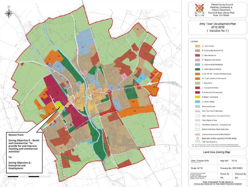
1.5     Next Steps
Following public consultation the Chief Executive of Kildare County Council will prepare
a report on the submissions and observations received in respect of the proposed
variations, respond to the issues raised and make recommendations in relation to the
proposed variations, taking into account the proper planning and sustainable
development of the area, the statutory obligations of the local authority and relevant
policies or objectives of the Government or any Minister of Government.

The elected members of Kildare County Council will consider the proposed variation and
the Chief Executives report.

1.6      Proposed Variation No. 2 of the Athy Town Development Plan 2012‐2018.
The proposed variation seeks to:
     • Amend the land use zoning of 3.4 hectares of land in Woodstock South, Athy from
         ‘R’ Retail and Commercial (To provide for and improve retail and
         commercial activities on the site’) to ‘Q’ Enterprise and Employment (To facilitate
         opportunities for employment and enterprise uses, manufacturing, research and
         development, light industry, employment and enterprise related uses within
         a high quality campus/park type development’); and
     • Amend Map 3.1 (Main Employment Zones), Map 16.1a (Zoning Map), Table
         16.1 (Land Use Zoning Category), Table 16.2 (Land Use Zoning Objectives), Table
         16.3 (Quantum of Zoned Land) and Table 16.5 (Land Use Zoning
         Matrix) of the Development Plan to reflect the proposed change in zoning.
1.7      Reasons for Proposed Variation to the Athy Town Development Plan 2012‐
         2018.
This variation is proposed in order to provide for the appropriate sequential expansion of
existing industrial facilities and to strengthen the employment base of Athy town, which are
in the interests of the proper planning and sustainable development of the area.

The purpose of land use zoning objective “R” is ‘to provide for and improve retail and
commercial activities on the site’. The proposed variation to amend this zoning to
provide for “Q”‐ ‘To facilitate opportunities for employment and enterprise uses,
manufacturing, research and development, light industry, employment and enterprise
related uses within a high quality campus/park type development’ is to provide clarity in
relation to the land uses that are permitted in principle on the subject lands. This will
enable the Planning Authority to consider any future planning application for the
appropriate expansion of the existing industrial facilities in the town or the development of
new employment/enterprise uses.

Kildare County Council has undertaken a Strategic Environmental Assessment
Determination in accordance with Article 13K of the Planning and Development
Regulations 2001 (as amended) which determines that Proposed Variation No. 2 to
the Athy Town Development Plan 2012 – 2018 is not likely to have significant effects on
the environment.

Kildare County Council has undertaken Appropriate Assessment Screening under Section
177V Part XAB of the Planning and Development Act 2000 (as amended) which
concludes in view of best scientific knowledge that Proposed Variation No. 2 to
the Athy Town Development Plan 2012 – 2018 individually or in combination with
another plan or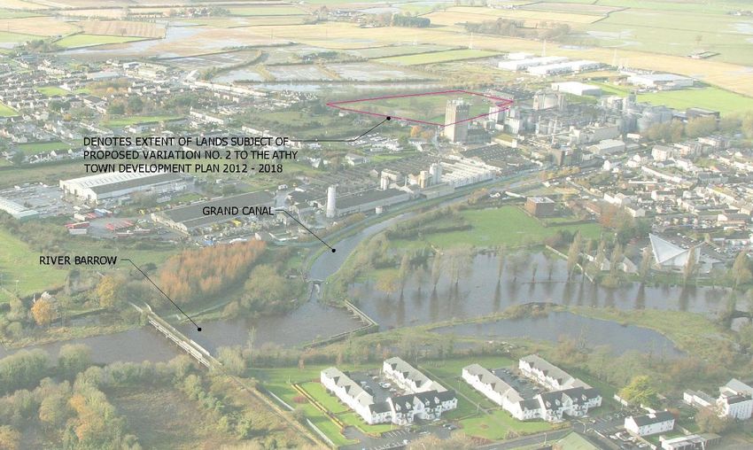
project is not likely to have a significant effect on a European site taking into account the
conservation objectives of any site and that there is no doubt or uncertainty in this
regard.

This document sets out the proposed changes to text, maps and graphics
throughout the Plan to reflect these changes.

1.8     How to Read this document
The document sets out the proposed amendments to the Athy Town Development Plan
2012 – 2018 in the order that they would appear in the Development Plan and includes
the text and mapping changes resulting from Proposed Variation No. 2.

Text amendments are represented as follows:

                                   Text remains as it is in the Athy Town Development
 Development Plan
                                   Plan 2012 – 2018.
                                   New text inserted into the Athy Town Development
 Development Plan
                                   Plan 2012 – 2018.
                                   Text deleted from the Athy Town Development Plan
 Development Plan
                                   2012 ‐ 2018.
Chapter 3 Economic Strategy

Amend Map 3.1 Main Employment Zones
Kildare County Council
                                                                                                                                               Planning Department,
                                                                                                                                            Áras Chill Dara, Devoy Park,
                                                                                                                                       c         Naas, Co Kildare.

                                                                                                                                     h
                                                                                                      Me
                                                                                                          an                         ea
                                                                                                               ma                n
                                                                                                                    a g u s Mi s

                                                                                                                      Athy Town Development Plan
                                                                                                                               2012-2018
                                                                                                                       ( Proposed Variation No 2 )

                                                                                               LEGEND:

                                                                                                                              A: Town Centre
                          H3
                                                                                                                              H, H1, H2, H4: Industrial & Warehousing
                     H
                                                                                                                              H3: Light Industrial & Commercial

                                                                      Remove                                                  Q: Enterprise & Employment

                                                                 H3
                                                                                                                              R: Retail / Commercial

                                                                                    H3                                        Rivers and Canals

                                                                                                                              Athy Town Council Boundary

                                                                                         H3

                                                                               H
                                                            H3

                                                                                   H1
                                       Amended Draft

                          Q
          H4

                                                       H2
                                   A
    H
                     H2
                                                       H2

                H
                               Q

                                                                                                 Note: This map should be read in conjunction with the Strategic Flood Risk Assessment for Athy (Refer to Appendix II)
                                                                                                 Note: Road, cycle and foot path locations are indicative only & may be subject to change during the detailed design process.

                                                                                                                              Main Employment Zones

                                                                                               Date: November 2017                                                   Map Ref:                   3.1
                                                                                               Revision Date: 10-11-17

                                                                                               Scale: N.T.S.                                                         Drawing No: 200/17/903

                                                                                               Ordnance Survey Ireland.
                                                                                              All rights reserved.                                                   Drawn By                           Checked By
                                                                                              Licence No.: 2004/07CCMA
                                                                                              (Kildare County Council)                                               MK                                 BR
Expand 'Q' Zoning,
                                                                                                           THIS DRAWING TO BE READ IN
Remove 'R' Zoning                                                                                    CONJUNCTION WITH THE WRITTEN STATEMENT
Chapter 16 Land Use Zoning
16.2.2 Land Use Zoning Category
Land use zonings are designated in this Development Plan in accordance with Table 16.1. Table 16.2
describes these zonings and the specific land use zoning objectives in greater detail.

Table 16.1: Land Use Zoning Category
 Ref.                  Land Use Zoning

 A                     Town Centre
 B                     Existing Residential & Infill
 C                     New Residential
 D                     Neighbourhood Centre
 E                     Community & Educational
 F                     Open Space & Amenity
 H, H1, H2, H4         Industrial & Warehousing
 H3                    Light Industrial & Commercial
 I                     Agriculture
 J                     Transport & Utilities
 Q                     Enterprise & Employment
 R                     Retail & Commercial
 U                     Public Utilities

Table 16.2: Land Use Zoning Objectives
 Ref             Use                          Land‐Use Zoning
                                              To provide for and improve retailing and commercial
                                              activities.

                                              The purpose of this zone is to provide for and improve retail
                 Retail               and     and commercial activities on a site at Woodstock South. The
 R
                 Commercial                   supermarket shall have a net retail area not exceeding
                                              3.000sqm in accordance with the Retail Planning Guidelines.
                                              Any additional retail/commercial development on the site shall
                                              be considered on its merits and in accordance with the
                                              provisions of the Plan.
                                              To facilitate opportunities for employment and enterprise
                                              uses, manufacturing, research and development, light
                                              industry, employment and enterprise related uses within a
                                              high quality campus/park type development.

                 Enterprise               &   This Plan seeks to retain and develop the existing
 Q                                            manufacturing industries in these areas while, establishing and
                 Employment
                                              expanding new categories of business in Athy and support
                                              their development. It is intended that these lands will be used
                                              for enterprise and employment uses in a high quality, well
                                              design environment. Development shall be of a high quality
                                              architectural design and landscaping. Along the Canal, new or
                                              infill development must have regard to the visual amenity of
the canal and the established uses in the immediate vicinity.
Any development on this site shall require a
detailed landscaping scheme at application stage

Possible uses for the Enterprise and Employment zone include:

Business, Science and Technology units: High tech, research
and development facilities, corporate and industrial offices.

Industrial Uses: Appropriately scaled extension to existing
industrial facilities

Office Based Industry: Where the activity is concerned
primarily with producing an end‐product (e.g.
software development, research and development) or
provides telephone or web based services (e.g.
telemarketing). Only office developments to which the public
do not normally have access will be permitted within the zone.

Enterprise and Incubator units: Small and mixed sized
workspace units suitable for small businesses and start up
companies. Limited light industrial development will be
considered in the context of the overall campus type
development.

Institutional Use: Includes medical facilities and educational
and knowledge based research facilities.

Support facilities: Without compromising the policy of resisting
inappropriately located retail and leisure development,
provision is made for small scale, “walk to” facilities (i.e.
restaurant, sandwich shop and specialist services such as
crèches) , which are integrated with employment units and are
of a nature and scale to serve the needs of employees within
this employment area.
Table 16.3: Quantum of Zoned Land

 Ref.         Specific Zoning Objective          Approx. Area (Ha)

 A             Town Centre                       33.4

 B             Existing Residential and Infill   222.2

 C             New Residential                   75.8

 D             Neighbourhood Centre              2.4

 E             Community and Education           43.0

 F             Open Space and Amenity            57.2

 H, H1, H2     Industry and Warehousing          51.1

 H3            Light Industry and Commercial     9

 H4            Industrial and Warehousing        3.1

 I             Agricultural                      434.7

 J             Transport and Utilities           7.6

 Q             Enterprise and Employment         38.6 42

 R             Retail and Commercial             3.4

 K             Public Utilities                  5.2
Table 16.5: Land Use Zoning Matrix
H3: Light Industry & Commercial
H1: Industry & Warehousingw
B: Existing Residential & Infill
Q: Enterprise & Employment
H2: Industry & Warehousing
H: Industry & Warehousing
E: Community & Education
D: Neighbourhood Centre
F: Open Space & Amenity
R: Retail and Commercial
J: Transport & Utilities
C: New Residential
U: Public Utilities
A: Town Centre
I: Agricultural
LAND USE
Amusement
O N N O N N N N N N N N N N N
Arcade
Broiler House N N N N N N N N N N Y N N N N
Car Parks Y N N O O N Y Y Y O N Y O O O
Cattle shed /
N N N N N N N N N N Y N N N N
Slatted Unit
Cemetery N N N N O O N N N N Y N N N N
Cinema/
Y N N N N N N N N N N N N O N
Dancehall/ Disco
Community Hall Y O O O Y O N N N Y N O O O N
Childcare/
Crèche/ Y O Y O Y O O O O O O O O O N
Playschool
Cultural Uses/
Y O O O Y O N N N N N N O O N
Library
Dwelling Unit Y Y Y Y N N N N N N O N N N N
Funeral Homes Y N N O Y N N N N Y N N O N N
Land Use N N N N N N O O O Y N Y N N N
Guest House/
Y O O O O N N N N N O N O N N
Hostel
Hotel Y N O O N N N N N N N N N N N
Halting Site N O O N O O N N N O O N N N N
Health Centre/
Y O O Y Y N O O O Y N O Y Y N
Clinic
Heavy
Commercial N N N N N N Y Y Y Y N Y N N N
Vehicle Parks
Take‐ Away O N N O N N N N N O N N O O N
Industry N N N N N N Y Y Y Y N O O O N
Industry (Light) O N N N N N Y Y Y Y N O O O N
Medical &
related Y O O Y Y N O O O O N O O O N
consultancy
Motor Sales Y N N N N N O O O Y N Y O N NNursing Home Y O O O Y N N N N Y O N N N N
Offices Y O N O O N O O O O N O Y O N
Park/
Y Y Y Y Y Y O O O O O N O O N
Playground
Petrol Station O N N O N N O O O Y N Y Y N N
Place of Worship Y O O O Y O N N N N N N O N N
Playing Fields O Y Y N Y Y N N N O Y N O O N
Pub Y O O O N N N N N N N N O N N
Recreational
Y O O O Y Y O O O O O O O O N
Buildings
Repository/
O N N N O N Y Y Y Y N O O O N
Store/Depot
Restaurant Y O O Y O N O O O O N O O O N
Residential
Y Y Y O N N N N N N N N N N N
Development
Retail
O N N N N N N N Y N N N N O N
Warehouse
School Y O O N Y O N N N N O N O N N
Shop
Y N N O N N N N N N N N N Y N
(Comparison)
Shop
Y O O Y N N O O O O N O O Y N
(Convenience)
Stable Yard N N N N N N N N N O Y N N N N
Sport/Leisure
Y O O O Y O N N N O N N O O N
Complex
Tourist camping
site/ caravan N N O N O N N N N N O N O N N
park
Utility
Y O O O O O Y Y Y Y Y Y O O Y
Structures
Warehouse
O N N N N N Y Y Y Y N N O N N
(Wholesale)
Waste
N N N N N N N N N N N N N N N
Incinerator
Workshop O N N N O N Y Y Y Y O Y O N OAmend Map 16.1a Land Use Zoning Map
The Sawyerswood
Bungalow House
Willsgrove
House
Foxhole
Bridge
Kildare County Council
Geraldine
Cross Roads
Planning Department,
Salisbury
House Áras Chill Dara, Devoy Park,
ac Naas, Co Kildare.
h
Me
an
ma a ne
Ardmore
House
g u s Mi s
Boat
House
Belview
House
Athy Town Development Plan
2012-2018
Geraldine
House
( Proposed Variation No 2 )
Clubhouse
Factory
Cuan Mhuire
(Rehabilitation Centre)
13
Athy Golf Club
Prusselstown Green
B
1 Golf Course
LEGEND:
Barrowford
House
Golf Course
A: Town Centre
I
714
Cardington
House
B: Existing Residential & Infill
7
70
Cardenton
I
C: New Residential
Cardenton House Golf Course
C34 C30
E
29
7
ES
D: Neighbourhood Centre
Barkersford
Bridge
1 Bearú
ain
Clu
D I
14
Rathsteward
House 20
C21
Ard
Bh
11
C31
e arú
E: Community & Educational
26
27
arú
nn Bhe
-3
25
Glea 14-
Boheranouca
2
H3
7
8-13
26
arú
1 1
Banta
Na Bhe 7 Cross Roads
7
1
C2
Bea
56 Corráin Elsinore
31
1
10
rú Mhó
Bh
ea
r
3-8
rú
1
6
ú 11
H
ear
Bh
Slí
57
41 -39
59
28 16
F: Open Space & Amenity
7
40
28-39
7
39
63
64
8
20
1
56
21
2
54 66
22
Lawn
67
10 68
Ra
11
stle
23
12
ths
24
tew
e Ca
73
25
48
art
Whit
26
74
Cr
75
es
Ra
76
27
26-39
an
ths
43
t
11
26
tew
34
12
25
Clonmullion 33
art
Retirement Village
Cre
10
C22
san
40
t
16-23
42
40-44
E
24-25
Closeburn
13
19
H, H1, H2, H4: Industrial & Warehousing
20
8
69
22
20 21
19
70
36
35
10-15
15
St Vincents
Hospital 45-50
32
8
E
1-9 5
4
35 34
1
75
30
6
76
20
C6
16
5
UPP
17
Mortuary
15
1
n
ER
tle Law
24
40
2 1
St
2
D
17
Cas
39
JOS
23
5
ROA
18
6
White
H
81
18
Rath
Ga
EPH
22
82
INE
7
Hollands Park llow
S TER
4
11
stew
ALD
Hil
l
18
18
GER
10
art
RAC
1
10
1
17
1277
Cre
36
E
30
1278
28
3
11
san
24
35
23
7
21 22
4
25
24
5
t
12
24
H3: Light Industrial & Commercial
89
14
6
1281
5
90
E
20
27
26
28
7
19
28
25 11 23
1304 10
22
14
1303
19
15
12
26
C8
H3
11
56
55
1
31
1290
21
1294
k
30
n Par
1291
D
32
32
22
l Walk 11A
37
30
48
Tow
Cana 47 11
38
1296 29
1295
1
LANE
Lennon's
8
34
Bridge
24
18
40
4
30
Tk
3
39
23
9
29
2
MONEEN
1
10A
Ga
1
10
k llo
32
13
31 21
w
25
22
Par 14
12
ry Hill
38
51
60
rbu
Ca
16
ES
8
SH
7
24 AM
18
ds
I: Agricultural
20
16
17
4 3 RO
23
53
llan 19
60
25-26 54 CK
49
Factory 1
e Ho
2 DR
12
2
18 56
Hall
53
42
E
IVE
1
17
Th
1
18
46
73
22
20
School
46
Fire Stn
J
16
12
21
24
24
D
45
25
15
65
23
59
Woodstock 60
Lodge 2 52
60
5
56
20
52
1
19
4
4
Flinters Place 66
H3
19
Manor 21 18
U
5
Rheban
71
20
11 70
5
33
3
53
Barrack Well
34
20
6 10 11 73
13
13-1
8
26
52
7 12
27
6
36
15
9
67
2
1
12
63
1
17
68
2 Tk 92
11
38
17
10
74
7
LOW
6
10
E
16
88 11
1305
1
Tk
Cas
ER
16
1306
9 85
1 2
tle
70 1
1
St
16
7
Par
15
JOS
14
96
5
Clonmullin Estate
k
66
6
Tow
11
EPH
14
38
6
78
20
15
n Par
45
5
r
S TER
no
46
47
39
k
E
Ma
97
2
K LAN
9-12
RAC
1
E H
RAC
t
J: Transport & Utilities
an
37
ur
67
BAR 19
82
E
28
102 42
Co
WO
eb
5 43 2
J
25
10
urt
OD
CON
6
Rh
s
106
1
Co 26
rl'
52
31
n 1317
STO
Flin
Ea
84
gto
Mc DONNE
L DRIVE
VEN
32
1318
ters
13
CK
rdin Mc DONNEL
15
34
118
Ca
T
Clo
48
114 37
47 114A
119
se
115
6
28
14
32
9
11
53 111
19-2
29
2
10
29
111A
LL DRIVE
27
0
12
1
44
30
5
Mc DONNEL
122
AD
12
39
57
RO
E
58
31
VIE
NE 38
45
33
INE
110
11
LA
32
17
STR
K 18
W
32
LD
AC 19
RA
16
Health 20 37
EET
L DRIVE
Centre RR 25
GE
36
24
BA
E
107
18
1
7
5
58
48
35
8
9
H3
9
53
34
3
6
51
7
5 49 50
8
11
33
12
2 4
LL DRIVE
Health Centre MCDONNE
22
2
1 1
21
Rheban
Manor
4
Grotto
Q: Enterprise & Employment
18
1
16
17
12
H1
1
D
ROA
1
E
17
School
16 The Orchard
INE
Tk
3 School
E
ALD
21
47
6 5
6
22
7
10 Church
GER
8
9
Woodbine Greenhills (Cath)
5
1
1
Martin's
7
2
Cottage Park
St Dominic
23
50
inic's 24
6
St Dom 45
23
5
44 School
Terrace
24
NS
HAWKI
4
30
's Park
2
MOUNT
32
PLACE
31
1
STANHOPE
KIRW
38
27
78
1
37
28
E
31
77
AN'S
STANH
12
F
Parochial Presbytery
12 11
House 1
LANE
St Dominic
OPE
2
Factory Club House
School
CHAPEL
BOY Church
STREE
(Presby)
BOHER Geraldine Park
6
's Park
83 5
LANE
7
78 BOHERBOY
35
T R: Retail / Commercial
36
74 76 14
70 3
1
7
12
11
6
WOODST
LANE 60
18 17
Bothar Buí
4
GARTER
Q
41
6
42
22
Factory
5
52 5 8
8
OCK
2
51 T 7
11
STREE
1
20 Stand
Rochfield
1
14-13 3 1 19
6
ER 15
17 - 16
85
LEINST
2
Railway
House
STRE
43 18 Station
Shan Rath
H4
Bank 1-6
86
Park
White
12
24
9
Castle
ET
16
9
30
St Michael's
10
15
11
87
Avenu
LANE 1 Ashville 29
N'S
5
10
JOH
4
29
88
Hotel
e
4 Fairfield
14
CHUR
St
LANE
5
33
89
1
2
Terrace
8
1
CH
7-24
Bank 6 24
30 Sports Ground
A
MEETING
2 3 23
Sports Ground
ROAD
EMILY
2
7
4 Church 36
5 (Meth) SQUARE
1
35
23
Toilets
1
LANE
9
EN
WLE
BARR
10
10
SHRE
NE
9
5
32
LSO
21
2
OW
31
1
9
U: Public Utilities
19
N
2 44
QUA
2
43
4
25-34 7
20
Butl
48 6 Town 13
STR
97
Y
3
Bank Hall
PO 12 6 Mansfield Grove
LANE
ers
LANE
'S LANE NG
EET
Fire Station
18
98
2
HIGGINSON MEETI 40 54
Lan
11 11 53 Show Grounds
St JOHN'S
39
1012
44
CONO
e
1
1
6
5 12 51 Tennis Ground
LLY'S
39 4
STREET 3
Q
2
DUKE 15 Court House
CON
16
38 50
LANE
37
19 15
33
101
15
32 23
VENT
3
1820
48
DUKE STREET 9
102
26 Library
4
47
27 10
Corn Mill
EMILY
14 11
LANE
30
21 31
20 20
ROW
1 12
7
2 8
14
STREET 15
28
17
1
WILLIAM
8
Factory 9
Remove
60
16
1- 4
21 Mansfield Grove
H2
13
4
14
5
GREEN ALLEY
OFFAL
6
58
22
Janeville
Place
Y
The Abbey
(in Ruin) VE
1
25
2 GRO
Sports Ground
57
Rivers and Canals
STRE
ROAD 31
56
Tk CH
5 -12
Rectory
ET
4
1
BEE
1-4
11
2
1
ET
RE
CH
ST
Church
8
Tk 32
(Cath) CHUR
LE 26
M
JANEVIL
LIA
3
G S Sta
WIL
H
Church 35
G S Sta
Crescent
R
CAN
PE
Tk
CAN
AL
UP
E
SIDE
AL
Tks
52
Factory 38
SIDE
50
Corn Church
(C of I)
Mill
49
St Dominic's
Priory
45
44
51
39
48
MOU
OURA
AUGHAB
47
NT
Tk
Factory
42
Athy Town Council Boundary
OFFA
8
J
LY
41
H2
9
16
U
17
14
13
H2
10
9
19
20
1 6
5
2
UE
AVEN
Factory ICK'S 24
23
F
St PATR
ES
29
30
33
34
6
CAR
F
36
o Court
LOW
H
Factory Marin
4
500m Intervals from the centre of Town
8
ROA
28
D
Woodstock
Close
1-11
RA
OU
1
27
12-25
8
AB
GH
7
26
Shrine AU
23
6
1
2
22
Tks 26-36
19 58
6
18
56
7
E
2
C11
53
24 13
1
23
KS
H
12
59
AR
8
ace
13
KP
Terr
Tk
AC
15
BL
Quarry 12 30
31
19
62
18
29
Q
25
Pái
Farm
26
s
man
rc
2
19
Plew
Bhr
63
Factory School
7
27A
1
ide
Sports Ground
34
Public Rights of Way
28A
18
6
1
52
70
24
29A 13
35
2
30A 3 12
66
67
Expand 'Q' Zoning,
FO
Dukes
50
Lodge
RT
99
38
BA
27
For
RR
94
est
ING
7
47
Par
28
39
TO
31
96
104
1
k
6
1
N
26
12
46
DS
RO
89
2
25
30
AN
I
AD
11
88
RL
J
2
29
Factory TE 21
22
AN
43
1
42
CH
3
Factory
83
ide
Bhr
50
90
2
rc
5
Pái
49
18
6
3
17
20
82
Dukes
86
Remove 'R' Zoning
21
18
5 6 78
77
Court
4
Ton
New Roads Objectives (Indicative only)
76
leg
10
ee
73
Law
15
E
25
Hall 61
J
ns
King
e
72
9 Driv
58
13
le
71
71
35
59
Tk nda 14
14
sgro
7
15
28
3
Avo
Funeral Home
3
16
68
2
ve
1
29
37
I
52
10
38
13
1
17
53
1
8
18
3
53
42
34
32
36
41
n
7
4
34
42
D Law
2
Oak
11
48
40
26
42
47
17
30
49
13
45
29
4
33
14
36
46
Ton
48 35
9
28
35
1
36
leg
23
45
Bennet's
39
ee
36
12
24
Bridge
Du
Law
26
6
8
35
41
25
ns
26
n Br
Northern Distributor Road Study Area
22
25
47
17
inn
56
D
38
18
23
32
MOU
92
41
30
40
31
42 18
NT
Ardre
29
57
14
16
38
23
37
Co
24
w Co
31
rrá
70
13
71
OFFA
n
15
Ár
Branswoo
1
urt
101
Kin
d
12
9
LY
d 8
C15
2
gsg
27
8
15
129
8
28
1
9
128
8
rove
10
1
1
5
16
To
14
7
4
13
nle
35
120
26
115
ge
24
1
e Co
6
18
7
49 50A
26
136
5
8
11
7
27
urt
36A37
121
F
1
4
12
105
106
51A
17
30
86
37A
16
114
13 14
52A5
Improvements to existing Road Network
144
15
1
3
32
34
38 38A
147
8
30
Dun Na Rí
5
Barrow View
3A
10
104
2
148 12
21 87 ad
22
18
Ro 1
11
1-32
ach
Ardre
1
28 Ble Creche
9
ue
w He
160 6 12 Aven
nn 14 1
1
161 9
36 n Bri Dun Na Rí
1
igh
178 Du
swood
25
1
10
29 Drive
ts
Riv
Bran 24 13
er
1
28
42
1
Vie
19
C12
1097
13 26
w
C13
1
Su
26 Green
18
Coneyboro
nny
40
sid
Reservation to allow upgrading of the Rail Bridge
e Law
72
1099
Burrow
Fo
10 31
ns
24
8
rtb
20
1
21
arr
W
73
s
88
al
Park
39
ing
k
37
ton
11
36-
35-
CAR
40 1
55
11
Drive
8 71 s
89
ws
Meadow
LOW
U
43
30
80
do
Mea
-33
37 48 47
34 33
-52
drew
44-
19
ROA
54
Ar 7
70
84-8
29
63
D
1000 Year Flood Line
26
46
20
53 1
83
-58
64
36 37
56
106
120
51 64 107
79 24
87 136
73 33
65 32 33
50 s
1110
32
Co
Meadow
19
29
rrá
47 21 31
n
148
Ár
88
Note: This map should be read in conjunction with the Strategic Flood Risk Assessment for Athy (Refer to Appendix II)
78
59
25
d
6
13
77
B
74 Bridgefield Manor
7-10
7 11 26
10 12
97 10
9
18
14
Note: Road, cycle and foot path locations are indicative only & may be subject to change during the detailed design process.
1
8
5
98 10
4
C20
2
134
1
1
12
135
C27
12
2
F Ardreigh Cross Roads
144
154
145
Corrá
n Árd
C26 Tonlegee House
Ardreigh
Cottage
I Land Use Zoning Map
Ardreigh House
C28
C33
Maybrook Fortbarrington
Date: November 2017 Map Ref: 16.1a
Revision Date: 10-11-17
Catto's Cross Roads
Scale: N.T.S. Drawing No: 200/17/902
Ordnance Survey Ireland.
All rights reserved. Drawn By Checked By
Licence No.: 2004/07CCMA
(Kildare County Council) MK BR
THIS DRAWING TO BE READ IN
CONJUNCTION WITH THE WRITTEN STATEMENTAppendix I ____________________________________________________ Strategic Environmental Assessment Screening Report
STRATEGIC ENVIRONMENTAL ASSESSMENT
                SCREENING REPORT

                                      FOR

                        PROPOSED VARIATION NO. 2
   (TO REZONE CERTAIN LANDS AT WOODSTOCK SOUTH AND CONSEQUENTIAL CHANGES)

                                     TO THE

        ATHY TOWN DEVELOPMENT PLAN 2012-2018
                     (AS VARIED)

for:       Kildare County Council
           Áras Chill Dara
           Devoy Park
           Naas
           County Kildare

by:        EIS
           1st Floor,
           24-26 Ormond Quay Upper
           Dublin 7

                                NOVEMBER 2017
SEA Screening Report for Proposed Variation No. 2 to the Athy Town Development Plan 2012-2018 (as varied)
Table of Contents
Section 1 Introduction and Terms of Reference ..................................................... 1
1.1 Introduction .....................................................................................................................1
1.2 Strategic Environmental Assessment Legislative Requirements .............................................1
1.3 The Proposed Variation .....................................................................................................2
1.4 Consultations ...................................................................................................................2
Section 2 SEA Screening.......................................................................................... 5
2.1 Introduction .....................................................................................................................5
2.2 Appropriate Assessment Screening .....................................................................................5
2.3 Stage 1 Flood Risk Assessment ..........................................................................................5
2.4 SEA Screening Analysis .....................................................................................................5
2.5 Schedule 2A .....................................................................................................................8
Section 3 Conclusion ............................................................................................. 11
EIS for Kildare County Council iSEA Screening Report for Proposed Variation No. 2 to the Athy Town Development Plan 2012-2018 (as varied)
Section 1 Introduction and Terms of Reference
1.1 Introduction
Kildare County Council has prepared Proposed Variation No. 2 (to rezone certain lands at Woodstock
South and consequential changes) to the Athy Town Development Plan 2012-2018 (as varied) under
Section 13 of the Planning and Development Act 2000 (as amended).
As the Council has not determined that the Proposed Variation would be likely to have significant
environmental effects, the Proposed Variation had to be screened for the need to undertake Strategic
Environmental Assessment (SEA). Screening is the process for deciding whether a particular plan -
or variation to a plan, other than those for which SEA is mandatory, would be likely to have
significant environmental effects, and would thus warrant SEA. This report provides the findings of the
evaluation of the requirement for SEA to be undertaken on Variation No. 2 to the Athy Town
Development Plan 2012-2018 (as varied). This report has been updated to take account of
submissions made as part of consultations on the SEA screening process.
The Athy Town Development Plan 2012-2018 was subject to full SEA and Stage 2 Appropriate
Assessment (AA). These processes, throughout which the environmental authorities were consulted,
facilitated the mitigation of potential environmental effects and the AA identified that the Plan would not
affect the integrity of any European Sites (except as provided for by the Habitats Directive).
1.2 Strategic Environmental Assessment Legislative
Requirements
SEA is the formal, systematic evaluation of the likely significant environmental effects of implementing a
plan or programme, or variation to a plan or programme, before a decision is made to adopt it. The SEA
Directive1 requires, inter alia, that SEA is undertaken for certain plans, programmes or variations to
these.
Under Article 7 (13K) of the Planning and Development (SEA) Regulations 2004 (SI No. 436 of 2004) as
amended by the Planning and Development (SEA) (Amendment) Regulations 2011 (SI No. 201 of 2011)2,
Kildare County Council is required to determine whether any Proposed Variation needs to be subject to
SEA. Screening is the process for determining whether a particular plan - or variation to a plan -, other
than those for which SEA is mandatory, would be likely to have significant environmental effects, and
would thus warrant SEA3.
Such a determination is required to take account of relevant criteria set out in Schedule 2A ‘Criteria for
determining whether a plan is likely to have significant effects on the environment’ of the SEA
Regulations, as amended, and submissions or observations from relevant environmental authorities.
1
Directive 2001/42/EC of the European Parliament and of the Council of Ministers, of 27th June 2001, on the Assessment of the
Effects of Certain Plans and Programmes on the Environment
2
Both sets of Regulations are collectively referred to as ‘the Regulations’ in this report.
3 It is noted that the SEA Directive requires that SEA is undertaken where Stage 2 AA is being undertaken however the emerging
findings of the AA screening process that is being undertaken on the Variation is that Stage 2 AA is not necessary (see Section 2.2).
EIS for Kildare County Council 1SEA Screening Report for Proposed Variation No. 2 to the Athy Town Development Plan 2012-2018 (as varied)
1.3 The Proposed Variation
The Variation proposes to:
1. Change the zoning of 3.4 hectares of land in Woodstock South, Athy from:
Zoning Objective R – Retail and Commercial: “To provide for and improve retailing and
commercial activities”
To:
Zoning Objective Q - Enterprise and Employment “To facilitate opportunities for employment and
enterprise uses, manufacturing, research and development, light industry, employment and
enterprise related uses within a high quality campus/park type development.”
2. Make consequential amendments to Maps 3.1 and 16.1A and tables 16.1, 16.2, 16.3 and 16.5 of
the Development Plan to reflect the proposed change in zoning.
The reasons for the Proposed Variation are to provide for the appropriate sequential expansion of
existing industrial facilities in Athy and to strengthen the employment base of the town, which are in the
interests of the proper planning and sustainable development of the area.
1.4 Consultations
As part of the screening process, authorities including environmental authorities4 were notified that a
submission or observation in relation to whether or not implementation of the Proposed Variation would
be likely to have significant effects on the environment may be made to the Council (a period of 3 weeks
was allowed for the reply). In order to help facilitate the environmental authorities’ response to that
notice, an earlier draft of this SEA Screening Report accompanied each notice. Each submission made in
response to the screening notice was taken into account in the finalisation of this report and in the
making of the SEA Screening Determination.
A submission received from the Environmental Protection Agency is responded to on Table 1.1.
The Health Services Executive submitted that they had no issues with the proposal. Letters of
acknowledgement were received from the Department of Education and Skills and the Health and Safety
Authority.
4
The following authorities were notified: Department of Agriculture, Food and the Marine; Department of Communications, Climate
Action and Environment; Department of Culture, Heritage and the Gaeltacht; Department of Housing, Planning and Local
Government; Environmental Protection Agency; Meath County Council; Offaly County Council; Laois County Council; Carlow County
Council; Wicklow County Council; South Dublin County Council; and Fingal County Council.
EIS for Kildare County Council 2SEA Screening Report for Proposed Variation No. 2 to the Athy Town Development Plan 2012-2018 (as varied)
Table 1.1 Response to EPA Submissions
Submission Text Response
SEA Determination Noted.
We note your position with regards to the need for Strategic
Environmental Assessment (SEA) of the Proposed Variation No. 2
to the Athy Town Development Plan 2012-2018 (the Variation).
Future Modifications to the Plan Noted. It is the practice of the Council to comply with the
Where changes to the Variation are made prior to finalisation, or Planning and Development (SEA) Regulations (as
where modifications to the Plan are proposed following its amended).
adoption, these should be screened for potential for likely
significant effects in accordance with the criteria as set out in SEA
Regulations Schedule 2A Criteria (S.I. No. 436 of 2004).
Infrastructure Planning The Town Development Plan includes provisions requiring
In proposing the Variation, and any related amendments, new development to be served by adequate and
variations etc. of the Plan, and in implementing the Variation, appropriate infrastructure.
adequate and appropriate infrastructure should be in place, or
required to be put in place, to service any development proposed
and authorised during the lifetime of the Plan.
Appropriate Assessment Appropriate Assessment (AA) screening is being
The requirements of Article 6 of Council Directive 92/43/EEC on undertaken on the Proposed Variation, in compliance with
the conservation of natural habitats and of wild fauna and flora, the Habitats Directive and the Planning and Development
the Habitats Directive should be taken into account. Appropriate Act (as amended). This AA screening process currently
Assessment, in accordance with the Directive is required for: concludes that it is considered that the Proposed Variation
“Any plan or project not directly connected with or necessary to will not have significant effects on the ecological integrity
the management of the site (Natura 2000 sites) but likely to have of any European Site5.
significant effect thereon, either individually or in combination with
other plans or projects, shall be subject to Appropriate Assessment
of its implications for the site in view of the sites conservation
Objectives…”
The National Parks and Wildlife Service (NPWS) should be
consulted regarding screening of the Variation for Appropriate
Assessment. Where Appropriate Assessment is required, any
findings or recommendations should be incorporated into the SEA
and Variation, as appropriate.
Environmental Authorities Noted - notice has already been provided to these
Under the SEA Regulations (S.I. No. 436 of 2004), as amended by authorities.
S.I. No. 201 of 2011, notice should also be given to the following:
The Minister for Housing, Planning and Local
Government
Minister for Agriculture, Food and the Marine, and the
Minister for Communications, Climate Action and
Environment, where it appears to the planning authority
that the plan or programme, or modification of the plan
or programme, might have significant effects on
fisheries or the marine environment
where it appears to the competent authority that the
plan or programme, or amendment to a plan or
programme, might have significant effects in relation to
the architectural or archaeological heritage or to nature
conservation, the Minister for Culture, Heritage and the
Gaeltacht, and
any adjoining planning authority whose area is
contiguous to the area of a planning authority which
prepared a draft plan, proposed variation or local area
plan.
A copy of your decision regarding the determination, including, as Noted - notice will be provided to these authorities.
appropriate, the reasons for not requiring an environmental
assessment, should be made available for public inspection at your
offices, local authority website and should also be notified to any
Environmental Authorities already consulted.
5
Except as provided for in Section 6(4) of the Habitats Directive, viz. There must be:
a) no alternative solution available,
b) imperative reasons of overriding public interest for the plan to proceed; and
c) Adequate compensatory measures in place.
EIS for Kildare County Council 3SEA Screening Report for Proposed Variation No. 2 to the Athy Town Development Plan 2012-2018 (as varied) Figure 1 Lands subject to the Proposed Variation identified on Town Plan Map 16.1 “Land Use Zoning Objectives” EIS for Kildare County Council 4
SEA Screening Report for Proposed Variation No. 2 to the Athy Town Development Plan 2012-2018 (as varied)

Section 2 SEA Screening

2.1 Introduction
The section examines whether each part of the Proposed Variation would be likely to have significant
environmental effects (and thus would warrant the undertaking of Strategic Environmental Assessment).

2.2 Appropriate Assessment Screening
Appropriate Assessment (AA) screening is being undertaken on the Proposed Variation. AA is an impact
assessment process concerning Natura 2000, or European, sites - these sites have been designated or
proposed for designation by virtue of their ecological importance.

The Habitats Directive6 requires, inter alia, that variations to plans undergo an AA process to establish the
likely or potential effects arising from implementation of the Proposed Variation. If the effects are
deemed to be significant, potentially significant or uncertain then the Proposed Variation must undergo
Stage 2 AA.

The AA screening process currently concludes that it is considered that the Proposed Variation will not
have significant effects on the ecological integrity of any European Site7.

2.3 Stage 1 Flood Risk Assessment
A Stage 1 Flood Risk Assessment (FRA) has been undertaken alongside the preparation of the Proposed
Variation that provides an appraisal and assessment of available flood risk data in order to identify flood
risk indicators in the Study Area.

The FRA concludes that no indications that the Study Area is at risk from fluvial, pluvial or groundwater
flooding such as would undermine the proposed variation were encountered. The FRA includes
recommendations that are consistent with the provisions contained within the Development Plan relating
to drainage and flood risk management.

2.4 SEA Screening Analysis
Table 2.1 examines whether each part of the Proposed Variation would be likely to have significant
environmental effects (and thus would have warranted the undertaking of Strategic Environmental
Assessment) and is supplemented by Table 2.2 which provides details on the potential environmental
effects (if unmitigated) and mitigating measures from the Plan (as varied).

This examination takes account of relevant criteria set out in Schedule 2A ‘Criteria for determining
whether a plan is likely to have significant effects on the environment’ of the SEA Regulations, as
amended (see Section 2.5).

The full range of environmental effects8, including cumulative effects are considered by this assessment.

6
  Directive 92/43/EEC on the conservation of natural habitats and of wild fauna and flora
7
  Except as provided for in Section 6(4) of the Habitats Directive, viz. There must be:
a) no alternative solution available,
b) imperative reasons of overriding public interest for the plan to proceed; and
c) Adequate compensatory measures in place.
8
  These include secondary, cumulative, synergistic, short, medium and long-term permanent and temporary, positive and negative
effects

EIS for Kildare County Council                                                                                              5
SEA Screening Report for Proposed Variation No. 2 to the Athy Town Development Plan 2012-2018 (as varied)
Table 2.1 SEA Screening

 No.    Part of the Athy Plan       Proposed Variation                                          SEA Screening      SEA Screening Determination Explanation
                                                                                                Determination

 1.     Chapter 16 “Land Use        Change the zoning of 3.4 hectares of land in Woodstock      SEA     is   not   This change in zoning involves replacing Zoning Objective R – Retail and Commercial
        Zoning”, Map 16.1 “Land     South, Athy from:                                           required.          with Zoning Objective Q - Enterprise and Employment.
        Use Zoning Objectives”
                                    Zoning Objective R – Retail and Commercial: “To provide                        Both of these zoning objectives favour built development to comparable extents.
                                    for and improve retailing and commercial activities”                           Different uses would be provided for under each zoning objective as is indicated in the
                                                                                                                   Proposed Variation document.
                                    To:
                                                                                                                   Indeed, these lands were zoned Q - Enterprise and Employment when the Draft Plan
                                    Zoning Objective Q - Enterprise and Employment “To                             and associated SEA Environmental Report were placed on public display in 2011. When
                                    facilitate opportunities for employment and enterprise                         it was proposed to change the zoning to the current R – Retail and Commercial zoning,
                                    uses, manufacturing, research and development, light                           the SEA Environmental Report Addendum (November 2011) identified no additional
                                    industry, employment and enterprise related uses within a                      effects arising from the change above those that had already been identified by the
                                    high quality campus/park type development.”                                    original SEA Environmental Report.

                                                                                                                   Parts of the subject lands are located within Inner and Outer Source Protection Areas
                                                                                                                   (these relate to the protection of drinking water resources) and all of the lands are
                                                                                                                   identified as being highly vulnerable to groundwater pollution. Measures which have
                                                                                                                   been integrated into the Plan as varied (including Surface Water and Drainage Policy
                                                                                                                   SW8) will ensure that any potential adverse effects on these sensitivities will be
                                                                                                                   mitigated. No other environmental sensitivities are identified within or adjacent to the
                                                                                                                   lands.

                                                                                                                   The proposed change does not have the potential to result in additional potential to
                                                                                                                   affect environmental sensitivities at or beyond the subject lands. Any development on
                                                                                                                   these lands will have to comply the detailed provisions of the Plan (as varied), including
                                                                                                                   those relating to environmental protection and management and service provision.

                                                                                                                   Please also refer to Table 2.2 and Section 2.5.

 2.     Various Parts of Chapters   Make consequential amendments to Maps 3.1 and 16.1A         SEA     is   not   Consequential changes do not result in any additional screening issues to those
        3 “Economic Strategy” and   and tables 16.1, 16.2, 16.3 and 16.5 of the Development     required.          discussed under No. 1 above.
        Chapter 16 “Land Use        Plan to reflect the proposed change in zoning.
        Zoning”

EIS for Kildare County Council                                                                                                                                                                                  6
SEA Screening Report for Proposed Variation No. 2 to the Athy Town Development Plan 2012-2018 (as varied)
Table 2.2 Summary of current Plan potential environmental effects, if unmitigated, and
associated mitigation measures
Environmental Likely Significant Effect, if unmitigated Mitigation Measure Reference(s) from
Components the Plan, including
Biodiversity and Flora Loss of biodiversity with regard to Natura 2000 Policies: CS 14, GT 15, NH 1, NH 2, NH 6,
and Fauna Sites and habitats and species listed under Annexes and NH 7 and NH9.
I and II of the Habitats Directive Objective NHO 7.
Loss of biodiversity with regard to ecological Policies: CS 13, NH 12 and NH 21.
connectivity and stepping stones Objective NHO 8.
Population and Human Spatially concentrated deterioration in human Policies: MA1, N 1, N 2 and WM 5.
Health health arising from exposure to incompatible land Objective ENO 4.
uses See also measures which have been included
under Water Services (Waste Water) and
Water Services (Drinking Water).
Soil Failure to maximise the sustainable reuse of Policies: CS 8, EDP6, HP6, UR 1 and UR 2.
brownfield lands
Water Adverse impacts upon the status of surface and Policies: WQ 1, WQ2, WQ 4 and WQ6.
ground water bodies Objective: WDO4.
Also see measures in this section under
Water Services (Waste Water).
Flooding Policies: HP28, SW1, SW3 and LU4.
Objectives: WDO13 and WDO14.
Material Assets Inadequate waste water treatment for new Policies WW3, WW4, WW5 and WS1.
populations Objectives: WDO2, WDO3 and WDO8.
Inadequate drinking water supply for new Policies: WS1, WS2, WS3, WS4, WS6,
populations & Reduction in water quality which WS10, WS12 and WQ7.
would present a potential danger to human health Objective: WDO5.
Air and Climatic Factors Increases in travel related greenhouse gas Policies: TM 3, WC 1, WC 4 and WC 7.
emissions and increases in car dependency
Cultural Heritage Effects on archaeological heritage including entries Policies: CS 12, AH1, AH 3, AH 4 and AH 6.
to the Record of Monuments and Places, including
Zones of Archaeological Potential
Effects on architectural heritage including entries to Policies: CS 12, PS 1, PS 7 and ACA1.
the Records of Protected Structures and Objective AHO1.
Architectural Conservation Areas
Landscape Visual impacts Policies: TE 5, VP 1 and VP 2.
EIS for Kildare County Council 7SEA Screening Report for Proposed Variation No. 2 to the Athy Town Development Plan 2012-2018 (as varied)
2.5 Schedule 2A
PART 1
1. The characteristics of the plan having regard, in particular, to: the degree to which the
plan sets a framework for projects and other activities, either with regard to the location,
nature, size and operating conditions or by allocating resources
The Variation proposes to: change the zoning of 3.4 hectares of land in Woodstock South, Athy
from Zoning Objective R – Retail and Commercial9 to Zoning Objective Q - Enterprise and
Employment10; and make consequential amendments to Maps 3.1 and 16.1A and tables 16.1,
16.2, 16.3 and 16.5 of the Development Plan to reflect the proposed change in zoning. Both of
these zoning objectives favour built development to comparable extents. Different uses would be
provided for under each zoning objective as is indicated in the Proposed Variation document. Any
development on these lands will have to comply the detailed provisions of the Plan (as varied),
including those relating to environmental protection and management and service provision.
Taking the above and the examination of the Variation provided under Section 2.4 into account,
arising from the degree to which the Plan (as varied) and associated Variation sets a framework
for projects and other activities, the Variation would not be likely to result in significant
environmental effects.
2. The characteristics of the plan having regard, in particular, to: the degree to which the
plan influences other plans, including those in a hierarchy
The Variation will not affect the consistency of the Plan (as varied) with the Kildare County
Development Plan 2017-2023. The Plan (as varied) is due to expire in March 2018 and it is not
expected that the Variation will affect lower tier plans.
Taking the above and the examination of the Variation provided under Section 2.4 into account,
arising from the degree to which the Plan (as varied) and Variation influence other plans, the
Variation would not be likely to result in significant environmental effects.
3. The characteristics of the plan having regard, in particular, to: the relevance of the plan
for the integration of environmental considerations in particular with a view to promoting
sustainable development
The Athy Town Development Plan - to which the Variation relates - has undergone SEA. This
process integrated environmental considerations into the Plan and found that the Plan
contributes to environmental protection and management and sustainable development.
Taking the above and the examination of the Variation provided under Section 2.4 into account,
arising from the relevance of the Plan and Variation for the integration of environmental
considerations in particular with a view to promoting sustainable development, the Variation
would not be likely to result in significant environmental effects.
4. The characteristics of the plan having regard, in particular, to: environmental problems
relevant to the plan
Environmental problems arise where there is a conflict between current environmental conditions
and legislative targets.
9
“To provide for and improve retailing and commercial activities”
10
“To facilitate opportunities for employment and enterprise uses, manufacturing, research and development, light industry,
employment and enterprise related uses within a high quality campus/park type development”
EIS for Kildare County Council 8SEA Screening Report for Proposed Variation No. 2 to the Athy Town Development Plan 2012-2018 (as varied)
Through its provisions relating to environmental protection and management, the existing Plan
contributes towards ensuring that environmental conditions do not get worse and, where
possible, it contributes towards its amelioration.
Taking the above and the examination of the Variation provided under Section 2.4 into account,
arising from environmental problems relevant to the Plan (as varied) and Variation, the Variation
would not be likely to result in significant environmental effects.
5. The characteristics of the plan having regard, in particular, to: the relevance of the plan
for the implementation of European Union legislation on the environment (e.g. plans linked
to waste-management or water protection)
The Plan (as varied) relates to the land use sector and has undergone SEA. This process
integrated considerations with regard to EU and national legislation on the environment into the
Plan (as varied), including those relating to the waste management and the Water Framework
Directive.
Taking the above and the examination of the Variation provided under Section 2.4 into account,
arising from the relevance of the Plan (as varied) and Variation for the implementation of
European Union legislation on the environment, the Variation would not be likely to result in
significant environmental effects.
PART 2
1. Characteristics of the effects and of the area likely to be affected, having regard, in
particular, to: the probability, duration, frequency and reversibility of the effects
The Variation would not be likely to result in significant environmental effects (see responses
under Schedule 2A Part 1 above and the examination of the Variation provided under Section
2.4).
2. Characteristics of the effects and of the area likely to be affected, having regard, in
particular, to: the cumulative nature of the effects
The Variation would not be likely to result in significant environmental effects (see responses
under Schedule 2A Part 1 above and the examination of the Variation provided under Section
2.4).
3. Characteristics of the effects and of the area likely to be affected, having regard, in
particular, to: the transboundary nature of the effects
The Variation would not be likely to result in significant environmental effects (see responses
under Schedule 2A Part 1 above and the examination of the Variation provided under Section
2.4).
4. Characteristics of the effects and of the area likely to be affected, having regard, in
particular, to: the risks to human health or the environment (e.g. due to accidents)
The Variation would not be likely to result in significant environmental effects (see responses
under Schedule 2A Part 1 above and the examination of the Variation provided under Section
2.4).
EIS for Kildare County Council 9SEA Screening Report for Proposed Variation No. 2 to the Athy Town Development Plan 2012-2018 (as varied)
5. Characteristics of the effects and of the area likely to be affected, having regard, in
particular, to: the magnitude and spatial extent of the effects (geographical area and size of
the population likely to be affected)
The Variation would not be likely to result in significant environmental effects (see responses
under Schedule 2A Part 1 above and the examination of the Variation provided under Section
2.4).
6. Characteristics of the effects and of the area likely to be affected, having regard, in
particular, to: the value and vulnerability of the area likely to be affected due to:
a) special natural characteristics or cultural heritage;
The Variation would not be likely to result in significant environmental effects (see
responses under Schedule 2A Part 1 above and the examination of the Variation provided
under Section 2.4).
b) exceeded environmental quality standards or limit values, and;
The Variation would not be likely to result in significant environmental effects (see
responses under Schedule 2A Part 1 above and the examination of the Variation provided
under Section 2.4).
c) intensive land-use.
The Variation would not be likely to result in significant environmental effects (see
responses under Schedule 2A Part 1 above and the examination of the Variation provided
under Section 2.4).
7. Characteristics of the effects and of the area likely to be affected, having regard, in
particular, to: the effects on areas or landscapes which have a recognised national, European
Union or international protection status
The Variation would not be likely to result in significant environmental effects (see responses
under Schedule 2A Part 1 above and the examination of the Variation provided under Section
2.4).
EIS for Kildare County Council 10SEA Screening Report for Proposed Variation No. 2 to the Athy Town Development Plan 2012-2018 (as varied) Section 3 Conclusion Screening is the process for deciding whether a particular plan or variation to a plan, other than those for which SEA is mandatory, would be likely to have significant environmental effects, and would thus warrant SEA. The purpose of the report is to provide the findings of the evaluation of the requirement for SEA to be undertaken on Variation No. 2 (to rezone certain lands at Woodstock South and consequential changes) to the Athy Town Development Plan 2012-2018 (as varied). The findings of the SEA screening process is that the Proposed Variation would not be likely to result in significant environmental effects. This SEA Screening Report has taken into account submissions made by authorities that were notified during the SEA screening consultation process. This report is accompanied by an SEA Screening Determination. EIS for Kildare County Council 11
You can also read