Prospectivity of the Triassic successions of the North West Shelf of Australia: New insights from a regional integrated geoscience study - CGG
←
→
Page content transcription
If your browser does not render page correctly, please read the page content below
Prospectivity of the Triassic successions
of the North West Shelf of Australia: New insights
from a regional integrated geoscience study
Jarrad Grahame1 and Victoria Cole2
https://doi.org/10.1190/tle40030172.1
Redistribution subject to SEG license or copyright; see Terms of Use at https://library.seg.org/page/policies/terms
Abstract associated with the breakup of the Gondwana Margin, commenced
The North West Shelf (NWS) of Australia is a prolific hydro- in the Norian, affecting the sedimentary basins of the NWS
carbon province hosting significant volumes of hydrocarbons, (Metcalfe, 2013; Zahirovic et al., 2016).
primarily derived from Jurassic and Cretaceous targets. A new More than 70 of the discoveries made in the NWS, with total
regional, integrated geoscience study has been undertaken to develop gas reserves approaching 150 TCF, are within Middle to Late
insights into the paleogeography and petroleum systems of Late Triassic reservoirs, mostly in the fluvio-deltaic sandstones of the
Permian to Triassic successions, which have been underexplored Mungaroo Formation and its equivalents. The recent Dorado oil
historically in favor of Jurassic to Cretaceous targets. Within the discovery in Middle Triassic reservoirs within the Bedout subbasin
NWS study area, graben and half-graben depocenters developed has sparked new interest in the hydrocarbon potential of the
in response to intracratonic rifting that preceded later fragmentation
and northward rifting of small continental blocks. This, coupled
with contemporaneous cycles of rising sea levels, brought about
the development of large embayments and shallow, epeiric seas
between the Australian continental landmass and outlying conti-
DOI:10.1190/tle40030172.1
nental fragments in the early stages of divergence. Key elements
of the study results discussed herein include the study methodology,
the paleogeographic and gross depositional environment mapping,
and the reservoir and source kitchen modeling. The study results
highlight the presence of depocenters that developed within oblique
rift zones due to regional Permo-Triassic strike-slip tectonics that
bear compelling similarities to modern-day analogues. These
intracratonic rift zones are well-known and prominent tectonic
features resulting from mantle upwelling and weakening of overlying
lithospheric crust, initiating the development of divergent intraplate
depocenters. The comprehensive analysis of these depocenters from
a paleogeographic and petroleum system perspective provides a
basin evaluation tool for Triassic prospectivity. Figure 1. NWS Triassic study coverage area, including the four major basins.
Introduction
The North West Shelf (NWS) is located
along the northwest coast of Australia covering
an area of 720,000 km², which developed
contemporaneously with breakup along the
eastern margin of Gondwana, with proven
petroleum systems ranging in age from
Paleozoic to Mesozoic (Purcell and Purcell,
1988) (Figure 1). Throughout the Triassic, the
NWS was located at the southern margin of
the Tethys Ocean. Depositional systems of
the four sedimentary basins are a function of
eustatic sea level changes and thermal subsid-
ence following the opening of the Tethys ocean
basins (Figure 2). Renewed tectonic activity, Figure 2. Late Triassic continental configuration (Tethys Sea), with warm ocean-current circulation.
CGG Multi-Client and New Ventures, Perth, Australia. E-mail: jarrad.grahame@cgg.com.
1
CGG Robertson, Llandudno, United Kingdom. E-mail: victoria.cole@cgg.com.
2
172 The Leading Edge March 2021 Special Section: Basin exploration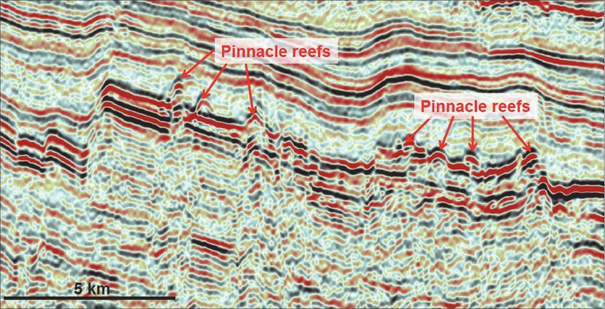
• create a tectonostratigraphic model
by relating the chronostratigraphy to
the evolving tectonic development of
the NWS
• define the regional geohistory
through the Triassic and illustrate this
on a series of NWS-wide gross deposi-
tional environment (GDE) maps, show-
ing the factors controlling the distribu-
tion of source, reservoir, and seal
• interpret a regional seismic grid to
prepare top and base Triassic depth
maps and a regional Triassic isopach
The results from the paleogeographic
and petroleum systems analysis of the
study highlight new insights into the
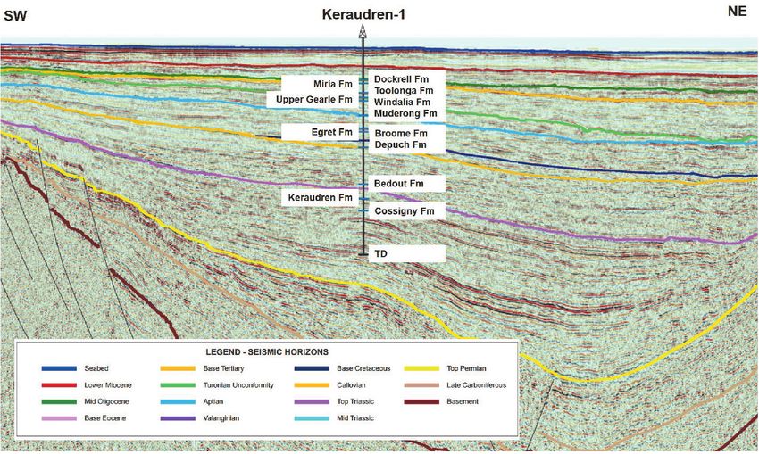
Figure 3. AGSO 2D seismic line S110r07 in the Bedout subbasin, with Keraudren-1 well and interpreted horizons. relationship between the intracratonic
rift environments and associated petro-
leum system development for Permo-
Triassic sediments of Gondwanan-
Westralian origin (Bradshaw et al.,
1994). Of particular relevance to the
topics discussed herein is the recognition
that the intracratonic depositional envi-
ronments were developing within an
oblique rift setting for much of the
Permo-Triassic, as evidenced by trans-
tensional features identified through
comprehensive interpretation of the data
(Figure 4). This evidence underpins the
new understanding of implications for
Figure 4. Early Triassic GDE map illustrating intracratonic depositional environment (CGG Plate Kinematics). petroleum development discussed
herein. The Mesozoic (Gondwanan)
Triassic sediments within the NWS. The Dorado discovery was petroleum systems of the NWS make up the primary focus for the
reported to hold 2C gross resource of 344 MMBOE (Carnarvon topics discussed herein (Loutit et al., 1997).
Petroleum, 2019). The Keraudren-1 well, located in close proximity
to the Dorado discovery and included on the seismic line in Geologic development
Figure 3, can be seen to intersect the Middle Triassic Keraudren Initial development of the NWS basins occurred as a result
Formation, which is the primary reservoir for the recent discovery of crustal extension along the eastern Gondwana Margin in the
in the Bedout subbasin. Other factors, such as the seismic iden- Paleozoic (Borel and Stampfli, 2002). In the Proterozoic, the
tification and drilling confirmation of Late Triassic reefs in primary structural complexes of the Australian Plate, the West
multiple settings and the improving knowledge of active Triassic Australian and North Australian cratons, were located in southern
source rocks in Timor-Leste, point to new plays and potential latitudes as part of the supercontinent Rodinia. Current plate-
within the Triassic successions. modeling knowledge based on the Robertson Plate Kinematics
The four basins of the NWS represent the area for a new model, as well as Metcalfe (2013) and Torsvik et al. (2012),
multidisciplinary study undertaken by CGG, the main aims of indicates that the NWS area was located in a continental setting
which were to: from the Ordovician onward. In the Carboniferous, the NWS
was located within the northeastern part of Gondwana, which
• enhance understanding of the prospectivity of NWS Triassic was composed of Western Australia (including the NWS) and
petroleum systems neighboring terranes, including Sibumasu, Qiantang, Lhasa,
• construct a database of key wells, hydrocarbon field data, and Northwest Borneo, and East Java/West Sulawesi. Commencing
seismic data in the Devonian, these terranes progressively rifted away from
• develop a reliable Triassic stratigraphy, including the Late Gondwana in consecutive tectonic phases. In the Triassic, the
Triassic carbonates, and present it on a series of chronostrati- NWS was located in an intracontinental plate setting (East
graphic summary charts Gondwana Interior Rift; Haig et al. [2017]) and was subject to
Special Section: Basin exploration March 2021 The Leading Edge 173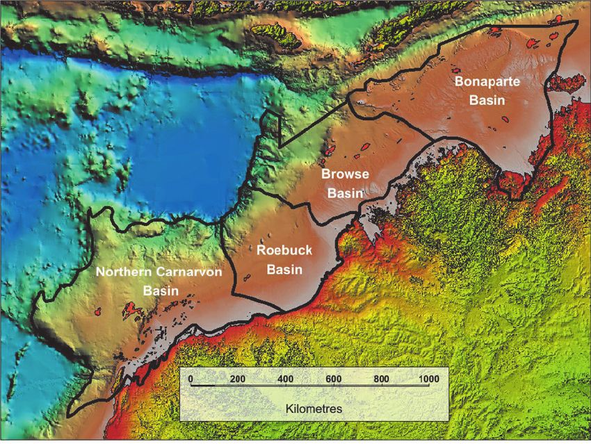
far-field stresses as a consequence of dynamic supraregional plate    Permian, Triassic, and Jurassic source rock quality and maturity
tectonics. In this context, the progressive breakup of the Gondwana   were analyzed in each of the NWS basins and then combined
continent provided an overriding set of controls on the evolution     with reservoir distribution and quality maps to derive play
of the NWS depositional environments. Despite this complex            fairways and overall prospectivity trends.
tectonic evolution, the development of the petroleum systems of
the NWS has a unifying tectonic theme of polyphase deformation        Results and discussion
on a basin scale that can be used to constrain the geologic record.        Clastic and carbonate reservoir sedimentology. More than 70
The present-day configuration of the NWS comprises four main          fields have their reservoir within fluvial and deltaic clastics within
northeast-trending basins, located predominantly within a passive     the Middle-to-Late Triassic Mungaroo Formation (and equiva-
margin setting. These are the Northern Carnarvon, Offshore            lents). This study has identified and documented additional clastic
Canning/Roebuck, Browse, and Bonaparte basins from southwest          reservoirs within the Triassic, including: the Mount Goodwin
to northeast, respectively.                                           Subgroup/Cape Londonderry Formation, consisting of shallow
    Specific reference is made here to the wrench faulting and        marine clastics, coastal clastics, and submarine fans; the Lower
normal faulting during the Triassic–Middle Jurassic synrift phases    Keraudren Formation, consisting of fluvial and deltaic clastics;
and the effects on depositional processes throughout the NWS          the Locker Shale formed of fluvial-deltaic clastics, shallow marine
basins. The present-day configuration of the NWS comprises four       clastics, submarine fan sand bodies, and basal transgressive sand-
main northeast-trending basins, located predominantly within a        stone; and the Early to Middle Triassic submarine fans and canyons
passive margin setting. These are the Northern Carnarvon,             around the Candace Terrace in the Northern Carnarvon Basin.
Offshore Canning/Roebuck, Browse, and Bonaparte basins from           In addition, the paleospace-oriented GDE mapping has led to
southwest to northeast, respectively.                                 the identification of several potential new play fairways, including
                                                                      subbasins where Bedout-analogue plays may have developed.
Study methodology                                                     Additionally, Early Triassic northerly sourced submarine fans on
     The study was undertaken within a multidisciplinary frame-       the Sahul Platform in the Bonaparte Basin, and Mungaroo/
work to yield new information from available data for the NWS.        Brigadier Formation equivalent shallow marine clastics derived
The data analyzed included regional 2D and 3D seismic data for        from the north (not the south, as usually predicted) in the Northern
basin-scale interpretation, physical well samples for core descrip-   Carnarvon Basin have been identified.
tion and cuttings sample analyses, well reports, and existing              Carbonate reservoirs. Three extensive Triassic reefal complexes,
biostratigraphic data. The study combined material from               mapped on seismic in the Northern Carnarvon and Browse basins
Commonwealth and State open-file databases with the compre-           and informally named the Logan, Collins, and Tierchert reef
hensive publications catalog of Petroleum Exploration Society of      complexes, provide promising new exploration targets (Figure 5).
Australia and Australian Petroleum Production and Exploration         Another two have previously been identified and drilled in the
Association publications.                                             Northern Carnarvon Basin, namely Playford and Wombat
     The study database includes samples and logs from 238 wells,     (Figure 5). The Tiberius-1 well was drilled in a bioherm and
as well as outcrop samples, including 28 from Timor-Leste. An         intersected 330 m of Late Triassic carbonate material, consistent
extensive data set of paleoenvironment control points was also        with an isolated reef buildup, with wireline log evaluation indicat-
compiled for GDE mapping, some of which were inherited from           ing average porosity of 13% and higher porosity zones. Massive
precursor CGG data sets (Robertson Predictions, 2017). In addi-       circulation losses in the well confirm well-developed, vuggy
tion, there are 35 new paleobiology paleoenvironment outcrop          porosity related to subaerial exposure and karstification (Grain
sites. Fourteen key wells were selected for the study: Barcoo-1,      et al., 2013). The Late Triassic reef targets of the NWS have yet
Brecknock-1, Central Gorgon-1, Jupiter-1, Lynher-1, Maple-1,
North Rankin-5, Observation-1, Phoenix-2, Scott Reef-1, Thebe-
2, Tiberius-1, Vinck-1, and Yampi-1.
     The key multidisciplinary elements of the study included
structural geology and basin evaluation; dynamic plate modeling
and paleogeographic reconstruction; petroleum system analyses,
including organic geochemistry and basin modeling; sedimentol-
ogy, biostratigraphy, and palynology; and detailed core descrip-
tion and sample analyses including petrography and automated
mineralogy. Two-dimensional and one-dimensional basin
modeling was used to establish the distribution of source kitchens
and the timing of hydrocarbon charge for both the new play
concepts and the established plays. The resulting analytical
results and interpretation formed the basis for new paleogeo-
graphic maps; tectonic models; GDE maps; schematic deposi-
tional models for key intervals; source rock and reservoir quality    Figure 5. Late Triassic reef complexes, Tiberius-1 well location, and West Foxhound
and distribution maps; and prospectivity summary maps.                3D. (Modified from Grahame et al., 2019).

174   The Leading Edge    March 2021                                                                                 Special Section: Basin exploration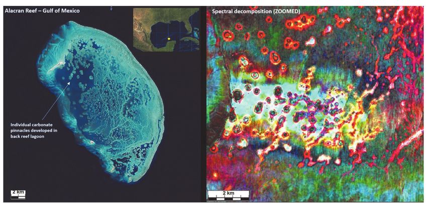
to yield any discoveries. However, their widespread distribution,                          Paleogeography. The main paleogeographic conclusions from
as identified on seismic data, provides encouragement for potential                  this study are presented as a series of 10 regional GDE maps
as a new play where they can be identified in close proximity to                     (see Figure 4 example). These maps were constructed using CGG
effective migration from underlying source rock (Figure 6).                          Robertson Plate Kinematics 2017 base maps and display the
     The CGG West Foxhound 3D survey provides good seismic                           data in “paleospace” — that is, with the correct latitude and
coverage of the inboard Collins reef complex as can be seen in                       orientation. The results leading up to and including the Triassic
Figure 5. The interpretation of the West Foxhound 3D represents                      depositional environments from the GDE mapping can be
a key seismic focus area for the NWS Triassic Study. The inter-                      summarized as follows.
pretation included attribute volume generation and analysis to                             In the Late Permian, Southwest Borneo, West Sulawesi, and
better define the size and distribution of the carbonate buildups                    East Java formed partly emerged areas of continental crust that
in the context of a depositional setting. Figure 7, which shows a                    intervened between what is now the NWS and the Meso-Tethys
spectral decomposition image example, highlights compelling                          Ocean (Figure 2). The NWS formed a broad (300–500 km wide)
similarities both in scale and depositional features with a modern-                  intracontinental seaway that extended for almost 3000 km from
day analogue, the Alacran Reef in the Gulf of Mexico. The spectral                   Lhasa in the west to a subduction-related uplift zone in the area
decomposition image is detailed enough to identify reefal con-                       that is now New Guinea in the east. This paleogeographic scheme
nectivity within the smaller buildups that would correspond to                       represents the dominant set of controls on sedimentation through
the shallower reef areas, as well as larger more isolated buildups                   the Triassic.
in the deeper lagoonal areas.                                                              In the Early Triassic, extensional deformation between Lhasa
     Areas have been identified where the carbonate complexes are                    and Greater India led to the development of a deep marine trough
overlain by Jurassic and Cretaceous sediments, providing potential                   and was responsible for the onset of extensional and strike-slip
seal/source units. The GDE mapping points to potential for similar                   deformation within the NWS. While the paleogeography estab-
carbonate development in other areas of the study basins.                            lished in the Permian persisted, the onshore Canning Basin was
                                                                                                                   inverted around this time, and erosion
                                                                                                                   of the Paleozoic basin fill commenced
                                                                                                                   (Zhan and Mory, 2013). Extensional
                                                                                                                   deformation between Lhasa and Greater
                                                                                                                   India was responsible for the develop-
                                                                                                                   ment of a deep marine trough here and
                                                                                                                   for the onset of extensional and strike-
                                                                                                                   slip deformation in the NWS. In the
                                                                                                                   Middle Triassic, the pattern and history
                                                                                                                   of the hinterland uplift and basin subsid-
                                                                                                                   ence regimes established in the
                                                                                                                   Olenekian persisted into the Anisian,
                                                                                                                   but the characteristics of the sediments
                                                                                                                   preserved at the southern margin of the
                                                                                                                   NWS basins indicate that the rate of
                                                                                                                   both the uplift in sediment source areas
                                                                                                                   and the subsidence in the basins
Figure 6. Interpreted Late Triassic pinnacle reefs on seismic line HB78-34.
                                                                                                                   increased. At this time, the deepwater
                                                                                                                   trough between Lhasa and Greater
                                                                                                                   India probably propagated southeast-
                                                                                                                   ward. Fluvio-deltaic depositional sys-
                                                                                                                   tems prograded at the southern margins
                                                                                                                   of the NWS basins, and canyon-like
                                                                                                                   features imaged on 3D seismic data at
                                                                                                                   the southern margin of the Carnarvon
                                                                                                                   Basin (McGee et al., 2017) are indica-
                                                                                                                   tive of accelerated rates of subsidence.
                                                                                                                        The Ladinian, Carnian, and Norian
                                                                                                                   GDEs share a set of common character-
                                                                                                                   istics associated with increased rates of
                                                                                                                   clastic sediment supply from rivers drain-
                                                                                                                   ing the Australian craton. Fluvio-deltaic
Figure 7. Late Triassic pinnacle reef complex (West Foxhound 3D). Spectral decomposition results compared with     depositional systems were sites for the
modern-day analogue (Alacran Reef, Gulf of Mexico). (Modified from Grahame et al., 2019).                          accumulation of good reservoir-quality

Special Section: Basin exploration                                                                                  March 2021 The Leading Edge          175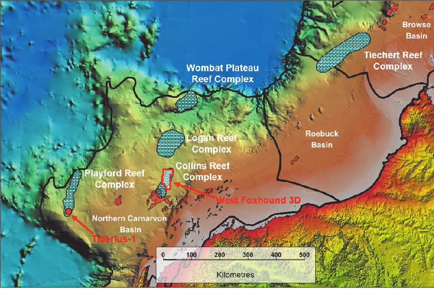
sand bodies. Coal swamps were an integral feature of the delta plain     Table 1. Source rock richness.
systems and, together with carbonaceous overbank and interdistribu-          Quality             Richness criteria (value)
tary bay mudstones, formed gas-prone source facies. The theme of
                                                                             Poor                < 100 kt HC/km²
increasing rates of clastic sediment supply continued into the Late
Triassic. The rate of progradation of fluvio-deltaic systems increased       Fair                Between 100 and 1000 kt HC/km²
in the Late Triassic such that Carnian deltas are significantly more         Good                Between 1000 and 10,000 kt HC/km²
extensive than their Anisian–Ladinian precursors. The fluvio-deltaic         Excellent           > 10,000 kt HC/km²
system that occupied the India/Australia Rift probably coalesced
with the Mungaroo system at this time to form an extensive sand-
prone reservoir tract in the Northern Carnarvon Basin. In the            with the purpose of collecting source rock and live oil seep samples
Carnian, the rate of clastic sediment supply to smaller systems at the   for geochemical analyses. The results show that there is evidence
northern margin of the NWS basins also may have increased.               of a carbonate source rock in the Middle–Late Triassic in Timor-
     In the Norian, the deepwater trough between Lhasa and               Leste that may provide an analogue to potential Triassic carbonates
Greater India continued to propagate southeastward. For this time        across the NWS. This includes geochemical evaluation on two
slice, numerous data points indicate deep, off-shelf environments        Triassic source rock samples (Babulu Formation) and 12 oils/seep
and facies, including deep marine cherts. These environments             samples from Timor-Leste (Robertson, 2017). The results show
were a precursor to the emplacement, prior to the Rhaetian, of           that the oils/seeps suggest three types of source rocks. Eleven of
oceanic crust. Extensional deformation was probably part of the          the oils/seeps are typed to two Jurassic source rocks (both inferred
mechanism driving both clastic sediment supply from uplifted             as Wai Luli Formation). These represent a gas-prone Type III
hinterlands and basin subsidence. The deltaic depositional systems       source rock and a mixed gas-oil Type II-III source rock. The
at the southern margins of the NWS basins reached their maximum          twelfth sample is typed to a Late Triassic marine carbonate source
progradational extent at this time. Reefal carbonates started to         rock (inferred as Aitutu Formation). The results on the extraction
accumulate in the warm waters of the NWS in the Norian and               of the two Triassic source rock field samples (Middle to Late
are well represented in the shallow waters of an archipelago inter-      Triassic Babulu Formation) differ from the oils/seeps results, and
preted at the southern flank of the Timor landmass. Deltaic depo-        therefore suggests an additional potential fourth source rock. The
sitional systems reached their maximum extent in the Late Triassic       presence and quality of these source rocks provides compelling
(Norian). The rate of clastic sediment supply to smaller systems         evidence that Triassic source rocks can provide charge for Middle
at the northern margin of the NWS basins also may have increased         to Late Triassic reservoirs.
at this time. The latest Triassic was marked by a change in subsid-
ence style and rising sea levels in the Rhaetian that were responsible   Conclusions
for a change from fluvio-deltaic clastic-dominated depositional              The conclusions of this integrated study regarding the pro-
systems to shallow marine environments including reefal reservoir        spectivity of the Triassic section on the NWS can be summarized
facies. The emplacement of new oceanic crust between Lhasa and           as follows:
Greater India was coincident with this change in the characteristics
of the sediments accumulating on NWS and represented a new               •      There is significant potential for well-developed reservoir
set of tectonic controls. A series of fault blocks hosting the Late             facies derived from Triassic clastic depositional environments.
Triassic reef systems were formed, creating an additional reservoir             More than 70 known fields have their reservoir within fluvial
facies. The fault blocks persisted into the Early Jurassic when                 and deltaic clastics, primarily within the Triassic Mungaroo
subaerial emergence was responsible for the creation of paleokarstic            Formation. The recent discovery of oil within the Keraudren
porosity. The deeper-water environments were probably sediment                  Formation in the Bedout subbasin attests to more widespread
traps that limited the extent of clastic sediments supplied from                distribution of these clastic reservoirs. The GDE mapping
the fluvio-deltaic systems that persisted into the latest Triassic. In          has led to identification of several potential new play fairways
the warm shallow waters, on the crestal parts of the fault blocks,              where Bedout subbasin analogue plays may have developed.
reefal carbonates accumulated and provide a record of a range of                These include Early Triassic northerly sourced submarine fans
reef, lagoon, and reef talus environments                                       on the Sahul Platform in the Bonaparte Basin and Mungaroo/
     Geochemistry. Geochemical analyses were undertaken on                      Brigadier Formation equivalent shallow marine clastics derived
organic-rich mudstone, claystone, and shale sections from the                   from the north in the Northern Carnarvon Basin.
Triassic interval in 14 key study wells. The results demonstrate         •      In addition to the clastic potential, the Late Triassic carbonate
the presence of multiple source rock intervals in the NWS. The                  reef complexes, as identified in this study and previously
source rock quality and richness observed in the study wells was                mapped, have been shown to have widespread distribution
used to generate four time slices to show the source rock quality               and well-developed secondary porosity as evidenced by the
and distribution through the Late Permian to Middle Jurassic                    drilling of the Tiberius-1 well in the outer Exmouth Plateau.
intervals (Grahame et al., 2019). The source rock richness is defined           With the exception of Tiberius-1, the Late Triassic reef com-
according to the criteria in Table 1.                                           plexes remain undrilled and represent a new and emerging
     In addition to the analysis undertaken for the 14 key study                exploration play where they can be found in close proximity
wells, a field sampling program was undertaken on Timor-Leste                   to active Permo-Triassic source rocks.

176    The Leading Edge     March 2021                                                                               Special Section: Basin exploration
•   The paleogeographic results highlight the presence of intracra-         kitchen modelling: Proceedings of Sedimentary Basins of Western
    tonic, mixed marine terrestrial depositional environments               Australia V, Petroleum Exploration Society of Australia.
    throughout the Permo-Triassic. The implications for source           Grain, S. L., W. M. Peace, E. C. D. Hooper, E. McCartain, P. J. Massara,
    rock development have been shown to be favorable within the             N. G. Marshall, and S. C. Lang, 2013, Beyond the deltas: Late Triassic
    Permo-Triassic. The geochemistry results have provided fresh            isolated carbonate build-ups on the Exmouth Plateau, Carnarvon
                                                                            Basin, Western Australia: Proceedings of the Western Australian
    insights and compelling evidence for active oil-prone Triassic
                                                                            Basins Symposium, Petroleum Exploration Society of Australia.
    source rocks as evidenced by NWS equivalent source rocks             Haig, D. W., A. J. Mory, E. McCartain, J. Backhouse, E. Håkansson,
    that have been correlated on Timor-Leste. The basin and                 A. Ernst, R. S. Nicoll, et al., 2017, Late Artinskian–Early Kungurian
    source kitchen modeling have shown potential for widespread             (Early Permian) warming and maximum marine flooding in the
    distribution of good- to fair-quality source rock development           East Gondwana Interior Rift, Timor and Western Australia, and
    throughout a number of areas for the NWS basins.                        comparisons across East Gondwana: Palaeogeography,
•   The integrated approach and methodology, leveraging extensive           Palaeoclimatology, Palaeoecology, 468, 88–121, https://doi.
                                                                            org/10.1016/j.palaeo.2016.11.051.
    geoscience resources, has shown to be successful in developing
                                                                         Loutit T. S., R. E. Summons, M. T. Bradshaw, and J. Bradshaw, 1997,
    new play concepts, identifying key areas for source rock and            The petroleum systems of the North West Shelf, Australia: Presented
    reservoir presence and quality, and generating fresh insights into      at the 15th World Petroleum Congress.
    the prospectivity of Triassic successions within the NWS.            McGee, R., J. Goodall, and S. Molyneux, 2017, A re-evaluation of the
                                                                            Lower to Middle Triassic on the Candace Terrace, Northern
Data and materials availability                                             Carnarvon Basin: APPEA Journal, 57, no. 1, 263–276, https://doi.
    Data associated with this research are confidential and cannot          org/10.1071/AJ16003.
                                                                         Metcalfe, I., 2013, Gondwana dispersion and Asian accretion: Tectonic
be released.
                                                                            and paleogeographic evolution of eastern Tethys: Journal of Asian
                                                                            Earth Sciences, 66, 1–33, https://doi.org/10.1016/j.jseaes.2012.12.020.
Corresponding author: jarrad.grahame@cgg.com                             Purcell, P. G., and R. R. Purcell, 1988, The North West Shelf, Australia
                                                                            — An introduction: Proceedings of the North West Shelf Symposium,
References                                                                  Petroleum Exploration Society of Australia.
Borel, G. D., and G. M. Stampfli, 2002, Geohistory of the North West     Robertson, CGG Services (UK) Limited, 2017, Field analysis report: East
   Shelf: A tool to assess the Palaeozoic and Mesozoic motion of the        Timor, geochemical analysis. Report No. 10532/Ic.
   Australian Plate: Proceedings of Sedimentary Basins of Western        Torsvik, T. H., R. Van der Voo, U. Preeden, C. Mac Niocaill, B.
   Australia 3, Petroleum Exploration Society of Australia.                 Steinberger, P. V. Doubrovine, D. J. J. van Hinsbergen, et al., 2012,
Bradshaw, M. T., J. Bradshaw, A. P. Murray, D. J. Needham, L. Spencer,      Phanerozoic polar wander, paleogeography and dynamics: Earth-
   R. E. Summons, J. Wilmot, and S. Winn, 1994, Petroleum systems           Science Reviews, 114, no. 3–4, 325–368, https://doi.org/10.1016/j.
   in West Australian basins: Proceedings of The Sedimentary Basins         earscirev.2012.06.007.
   of Western Australia, Petroleum Exploration Society of Australia.     Zahirovic, S., K. J. Matthews, N. Flament, R. D. Müller, K. C. Hill, M.
Carnarvon Petroleum, 2019, Annual report, https://www.carnarvon.            Seton, and M. Gurnis, 2016, Tectonic evolution and deep mantle structure
   com.au/wp-content/uploads/2019/08/annual-report.pdf, accessed 2          of the eastern Tethys since the latest Jurassic: Earth-Science Reviews
   February 2021.                                                           162, 293–337, https://doi.org/10.1016/j.earscirev.2016.09.005.
Grahame, J. P., J. Harris, V. Cole, M. Urbat, Y. Santerre, C. Gilman,    Zhan, Y., and A. J. Mory, 2013, Structural interpretation of the northern
   and S. Roy, 2019, Hydrocarbon potential of the Heywood Graben,           Canning Basin, Western Australia: Proceedings of Sedimentary Basins
   Vulcan Sub-basin: New regional paleogeographic analyses and source       of Western Australia IV, Petroleum Exploration Society of Australia.

Special Section: Basin exploration                                                                          March 2021 The Leading Edge         177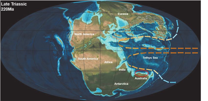
You can also read