Real time assimilation of GOES-16 total lightning into the NSSL 3DVAR code to improve 0-12h forecasts of high impact weather events at cloud ...
←
→
Page content transcription
If your browser does not render page correctly, please read the page content below
Real time assimilation of GOES-16 total lightning
  into the NSSL 3DVAR code to improve 0-12h
forecasts of high impact weather events at cloud
                 resolving scales

                    Alexandre O. Fierro
   CIMMS-NSSL/NOAA - The University of Oklahoma

 Collaborators: Junjun Hu, Yunheng Wang, Jidong Gao, Ted
 Mansell, Israel Jirak, Adam Clark, Ming Hu, Eric James, Don
                          MacGorman
                                                    Photo credit: J. LaDue
Four main methods of lightning data assimilation were investigated
by CIMMS-NSSL thus far:

1. Using lightning to force convection initiation by nudging qv where
lightning is observed but convection is absent in the model. Forcing is
maintained for 10s of minutes to achieve a model response to sustain
storms.

2. Variational (3DVAR) assimilation with high frequency (
Lightning DA used in real time during the SFE in a nutshell:

 Boosts thermal buoyancy via Qv adjustments toward water
 saturation (RH=95%) between LCL and LCL+3km.
                                             1-h forecast

                                     No DA                      GLM DA

           +                                                forecast

      Background Qv                                Adjusted Qv

                          3DVAR
                          analysis

                                                                   Fierro et al. (2019, MWR)
Real time DA during the SFE:   -Use CLUE domain (3-km,
                               4860 km x 3360 km) and
                               HRRRv4 model with RAPv5
                               input data.

                               -DA performed daily between
                               23-00UTC.

                               -Use 15 min 3DVAR cycles
                               with 10-min acc GLM data.

                               -At 00UTC, a 12 h
                               deterministic fcst is launched.

                               -A sample of 29 fcst days
                               was obtained.

                               -Analysis focus on precip;
                               contrasts eastern 2/3 vs
                               western 1/3 CONUS (good
                               vs poor radar coverage
                               areas).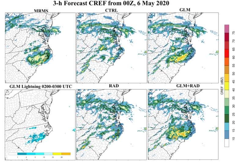
SFE Experiments
Experiments Description Data assimilated variationally Model variables
adjusted
CTRL Control run None None
GLM GLM flash density rates. qv (LCL-3 km)
Lightning DA run.
RAD Vr and dBZ qr, qg, qs, qh, u, v, w,
Radar DA run
RAD+GLM Lightning + Radar DA run GLM flash density rates, Vr qv (LCL-3 km), qr, qg, qs,
and dBZ qh, u, v, w,
-Level II (Vr+ dBZ factor) data from 140+ radars were assimilated.
-SFE eval during HWT solely focused on RAD-based experiments over the
western 1/3 CONUS to gauge added value of GLM in radar-data sparse
areas.
-CTRL and GLM DA run performed and analyzed offline during SFE.
SFE/HWT real-time experiment over CLUE domain; preliminary
results

                                                          Performance diagrams
                                                          aggregated over all 29
                                                          forecast days over
                                                          CONUS for 1, 3 and 6-h
                                                          forecast show a general
                                                          improvement in forecast
                                                          skill over CTRL for all DA
                                                          runs; with the best
                                                          results obtained for
                                                          GLM+RAD.

                                                          Individual cases reveal
                                                          that assimilating GLM
                                                          data showed benefit in
                                                          radar-sparse areas such
                                                          as the mountainous
                                                          west, the Gulf of Mexico,
 Excellent performance of CTRL is explained by RAPv5      East cast and the Sierra
 data already blending info from a large arrays of obs,   Madre in Mexico.
 including lightning and radar.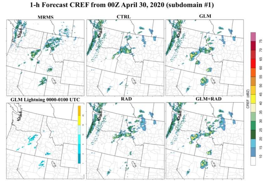
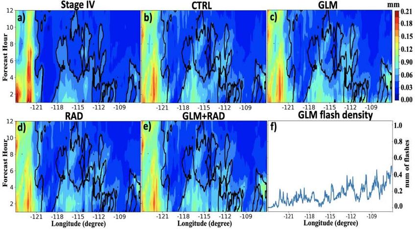
SFE/HWT real-time experiment; preliminary results

                  0-6h rainfall aggregated over 29 fcst days

   GLM DA adds in more precipitation during the first 2-3h of forecast,
   especially over the eastern 2/3rd of CONUS where bulk of lightning occurs.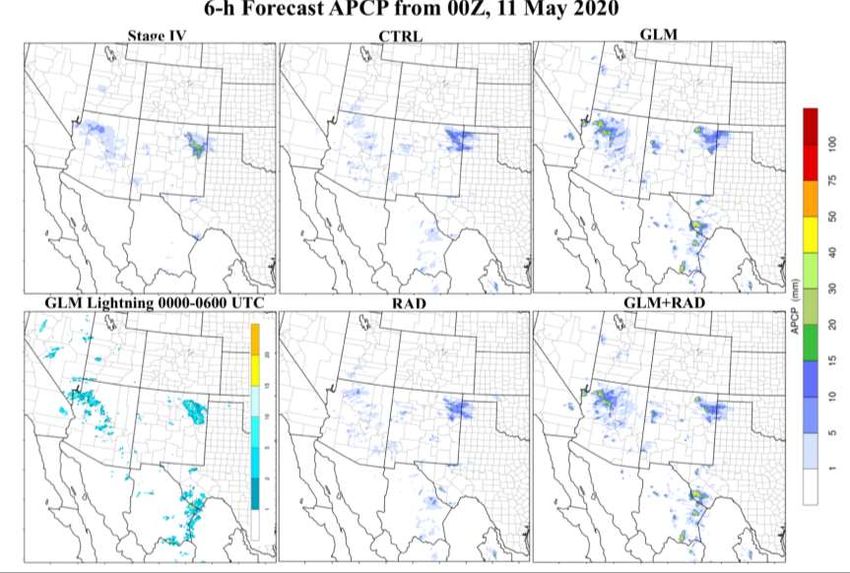
SFE/HWT real-time experiment; preliminary results
                                                               Mask
Western US: Relatively less rainfall is added overall by RAD
or GLM DA owing to the weaker convective nature of the
storms over the western CONUS (e.g., monsoon storms).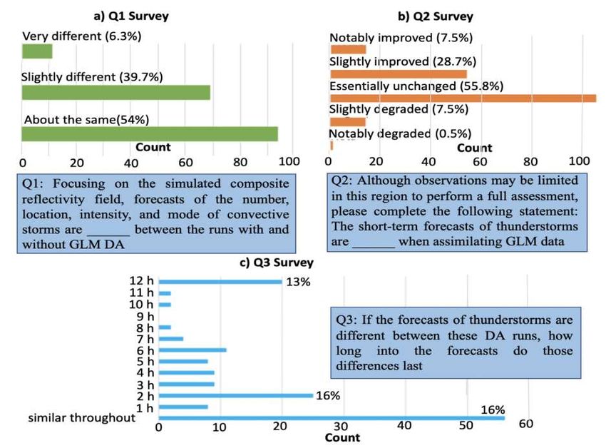
SFE/HWT real-time experiment; Individual cases
         Western US: example of GLM DA improvements over
         areas characterized by poor radar coverage
SFE/HWT real-time experiment; Individual cases
         Western US: example of GLM DA improvements over
         areas characterized by poor radar coverage (rainfall)
SFE/HWT real-time experiment; Individual cases
Western US: Other example of GLM DA improvements
over areas characterized by poor radar coverage (rainfall)SFE/HWT real-time experiment; Individual cases
Eastern 2/3rd US: example of GLM DA improvements
over areas characterized by good radar coverageSFE/HWT participant survey analysis:
Ongoing and future work involving GLM DA

•Complete analysis of HRRRv4 real time radar +/ GLM DA runs
 conducted during the SFE of Spring 2020.
•Combine Radar and GLM DA with sfc obs such as Mesonet
 and/or satellite products.

•More systematic usage of hybrid VAR-EnKF implementation for
 GLM lightning using Qv- or RH-based operators.

•Parallel work also evaluating GSI-EnKF hybrids DA of GLM FED
 data using Qg-based obs operators.

•Evaluate FOD vs FED assimilation.

•Until JEDI ready for research applications, couple NSSL-VAR
 with FV3 / FV3-SAR core.
Lightning DA manuscripts from 2019 onward:
Hu J., A. O. Fierro, Y. Wang, J. Gao, E. R. Mansell, A. J. Clark, I. Jirak and M. Hu, 2020: Assessment of storm-scale
real time assimilation of GOES-16 GLM lightning-derived water vapor mass and radar data on short term
precipitation forecasts during the 2020 Spring forecast experiment. Submitted to Monthly Weather Review.

Hu J., A. O. Fierro, Y. Wang, J. Gao and E. R Mansell, 2020: Exploring the Assimilation of GLM-Derived Water Vapor
Mass in a Cycled 3DVAR Framework for the Short-Term Forecasts of High-Impact Convective Events. Monthly
Weather Review. Volume 148, 1005-1028.

Hu J., J. Gao, Y. Wang, S. Pan, A. O. Fierro, P. Skinner, K. Knopfmeier, E. R. Mansell and P. Heiselman, 2020:
Evaluation of a Warn-on-Forecast 3DVAR analysis and forecast system on quasi- real time short-term forecasts of
high impact weather events. Submitted to Quarterly J. Royal. Metr. Soc.

Fierro, A. O., Wang. Y, Hu J., Gao J., and E. R. Mansell, 2020: Proof-of-concept evaluation of ensemble of
3DEnVARs assimilation (ENH3DA) of GLM-observed total lightning data for the 1 May 2018 tornado outbreak.
Submitted to Monthly Weather Review.

Fierro, A. O., Wang. Y, Gao J., and E. R. Mansell, 2019: Variational assimilation of radar data and GLM-lightning
derived water vapor for the short-term forecasts of high-impact convective events. Monthly Weather Review. Volume
147, 4045-4069.

Rong K., M. Xue, A. O. Fierro, Y. Jung, C. Liu, E. R. Mansell and D. R. MacGorman, 2020: Assimilation of GLM-
observed Flash Extent Density in GSI EnKF: Proof-of-concept for the Analysis and short-term Forecast of the 13 July
2018 Mesoscale Convective System. Monthly Weather Review. Volume 148, 2111-2133.

Kong R., M. Xue, C. Liu, A. O. Fierro, E. R. Mansell, and D. R. MacGorman, 2020: Assimilation of GOES-R
Geostationary Lightning Mapper Flash Extent Density data in GSI 3DVar, EnKF, and Hybrid En3DVar for the Analysis
and Short-Term Forecast of a Supercell Storm Case. Submitted to Monthly Weather Review.

Prat A. C., S. Federico, R. C. Torcasio, A. O. Fierro, Stefano Dietrich, 2020: Lightning data assimilation in the WRF-
ARW model for short-term rainfall forecasts of three severe storm cases in Italy. Submitted to Atmos Res.
Extra slides for questions
Types of lightning data assimilated:
(1) Ground based networks divided in 3 categories
     - VLF (global/intl: WWLLN, GLD360, ZEUS). 3–30 kHz
     - Broadband (intl: ENTLN). 1 Hz–12 MHz
     - VHF (regional: LMA). 30–300 MHz
(2) Spaceborne optical instruments
     - Low Earth Orbit (TRMM-LIS)
     - Near Polar Orbit (OTD-Microlab-1)
     - Geostationary (GEOSR GLM / FenYun4 LMI/ MTG)

       Each of these technologies sees or detects
      different physical aspects of lightning flashes
         (photon emission versus dE/dt pulses or
      sferics), which must be accounted for during
                      DA exercises.
Spaceborne optical instruments: GLM
2018 GLM Data:
Characteristics
•Staring CCD imager (optical)
(1372x1300 pixels)
•Near uniform spatial resolution
8 km nadir, 12 km edge fov
•Coverage up to 52 deg lat
•70-90% flash detection day and night
•2 ms frame rate
•< 20 sec product latency
•Delivers three primary “lightning
variables” related by parent-to-child
relationships based on fixed time &
spatial thresholds: Events, groups and
flashes.
Different instruments observe same phenomenon
differently challenge for DA applications!
Petersen, (2019), JGRGLM gridding/prep for DA -8-12 km GLM pixel sizes purposively thinned down to 2km to reduce mass adjustments in the model. -This was shown to help reduce wet bias potential while yielding similar improvements in forecast skill (Hu et al. 2020, MWR) . -Method essentially equivalent to reducing horizontal length scale of the control variable Qv in 3DVAR analysis.
Flash metrics options for DA:

                                3D channel volume
Lightning DA: create pseudo-observations • Lightning not explicitly predicted in typical operational NWP Find a proxy for lightning. • Lightning presence of moist mixed phase convection -> saturated (buoyant) ascent (wrt to water). • Boost water vapor mass Qv within a fixed layer above cloud base (LCL) towards Qsat_water. Concomitantly, increasing Qv at constant T boosts thermal buoyancy (via θv) and, ultimately, promotes updraft development. • CAPE within 2-3 km layer above LCL most efficiently converted into KE + updrafts will be more systematically rooted in BL. • Only applied whenever simulated RH= Qv / Qsat_water < fixed thresholds: i.e., if the model already is in the right direction don’t adjust Qv. • Project L2 GLM “flash” centroids onto CAM (dx= 3-km) grid. • Account for ~9x9 km2 pixel resolution of the GLM by spreading footprint on 3-km grid as shown here • Create 3D pseudo Qv observations that are minimized in cost function.
Spaceborne optical instruments: GLM

Petersen, (2019), JGR: longest lasting 2018 GLM flash
VAR Lightning DA: Background What is variational DA? Two main types: 3DVAR and 4DVAR. •3DVAR: Find the optimal analysis x=xa that minimizes a (scalar) cost function, proportional to the sum of the Euclidian distances between x and the background xb (initial guess), plus the distance between x to the observations yo, each weighted by a measure of their respective errors (covariance matrix). Derivation: •Assume that x=xa is a realization of a random process defined by the prior probability distribution function (given the background field) . •Prob distributions are Gaussians [fully described by 1st and 2nd moments]. •Obs and background error are uncorrelated and unbiased •Baye’s theorem yields to: The x that minimizes the minus of the exponent (cost function) is the x that maximizes the probability of the analysis. 3DVAR = optimal analysis estimator given the obs yo.
VAR Lightning DA: Background
The minimum of the quadratic cost function is found by an iterative
procedure such as gradient descent; illustrated below for a linear model.
Ground based networks
Broadband vs VLF: ENTLN (CG+IC) versus NLDN
(mainly CGs)

    ENTLN/NLDN ≈ (IC+CG)/CG Ratio of 9x9-km 10-min
gridded flash counts ranges from 2 to 10. IC+CG also spans
 a larger area. IC also better correlated with W and hence,
                  timing of the convection.
Ground based networks: Time of Arrival Locate 1-2 (VLF) to 1000+ (VHF) sources per flash dr/dt=c
Nebraska storm (1-2 min exposure)

                                        Credit: G. Takei

            (IC+CG)/CG Ratio = 5,10 ?
You can also read