Release Guide ERDAS APOLLO 2020 - Hexagon AB
←
→
Page content transcription
If your browser does not render page correctly, please read the page content below
Release Guide

Release Guide
ERDAS APOLLO 2020

Version 16.6.0
26 September 2019
Contents
About This Release ........................................................................................................................ 3

New Platforms ................................................................................................................................ 4
   Java...............................................................................................................................................4
   Operating Systems .......................................................................................................................4

New Technology ............................................................................................................................. 4
   New Catalog Client .......................................................................................................................4
   Advanced Logging Charts ............................................................................................................5
   AOI Notification Service ...............................................................................................................5
   ECWP Browser Streaming Lives Again .......................................................................................6
   Cloud Optimized ECW..................................................................................................................7
   Other Improvements .....................................................................................................................7

System Requirements ................................................................................................................... 9
   ERDAS APOLLO ..........................................................................................................................9

Issues Resolved ........................................................................................................................... 11
   ERDAS APOLLO Core 2020 ......................................................................................................11
   ERDAS APOLLO Advantage/Professional 2020 .......................................................................14
   Geospatial Portal 2020 ...............................................................................................................16

Contact Us .................................................................................................................................... 18

About Hexagon ............................................................................................................................. 18

Copyright....................................................................................................................................... 19

14 October 2019                                                                                                                                      2
About This Release
Enhancements for ERDAS APOLLO 2020 are described in this document.

This document is only an overview and does not provide all the details about the product's capabilities.

See the online help and other documents provided with ERDAS APOLLO for more information.

                                  IMPORTANT
                                     NOTICETHIS RELEASE
   READ CAREFULLY BEFORE YOU START INSTALLING

If multiple Hexagon’s Geospatial division products are installed on the same server, it is required that every
Platform Suite and Provider Suite product that is installed on the server must have the same release and patch
version. Before you start installation, follow these steps to facilitate the server update process:

  1.    Verify the versions of the products installed on the server
  2.    Check if the product installation/upgrade concerns two or more of the following products:

             •    Platform Suite: GeoMedia WebMap, Geospatial SDI, or Geospatial Portal
             •    Provider Suite: ERDAS APOLLO

  3.    Make sure that for the products detected in point (2), there are compatible versions available.

Make sure all products detected in step (2) that are not compatible are upgraded to a compatible version
before you initiate the ERDAS APOLLO instance upgrade procedure. Do not proceed with the installation if
any of the products installed on the server do not provide a compatible patch.

Please contact Support in case of any questions regarding compatibility of products and patches.

14 October 2019                                                                                             3
New Platforms
Java
With the ERDAS APOLLO 2020 release, Java remains an external dependency in the server application and
now also the Data Manager. ERDAS APOLLO 2020 is certified on the latest Long Term Supported (LTS)
versions from Oracle (version 8 or 11), including other Java platforms such as OpenJDK and Amazon Corretto.

Operating Systems
Windows Server 2019 has now been certified as a Supported Platform for this release. In line with Microsoft’s
own product lifecycle, we recommend existing customers currently using Windows Server 2012 R2 start
planning to upgrade.

For ERDAS APOLLO Essentials Linux customers, support for Redhat v6.x has now been deprecated. ERDAS
APOLLO 2020 now only supports v7.x based platforms and once more widely available we intend to add
support for v8.x in an upcoming update.

New Technology
New Catalog Client
Soon after the general availability of ERDAS APOLLO 2020, a new, modernized web client will be released.
The client will be based on the LuciadRIA framework and serve as an integrated catalog client for both ERDAS
APOLLO and LuciadFusion, allowing federated search to bridge both server capabilities. Other highlights
include:

    •   Gazetteer
    •   Federated catalogs, including HxGN Content Program
    •   2D or 3D views, including OGC 3D Tile support
    •   Enhanced download features
    •   Advanced queries

14 October 2019                                                                                                 4
Since the client will be compatible with multiple catalog types, it will be delivered as its own package and will
align with other LuciadRIA updates.
Having a central web client solution that appears identical to LuciadFusion is highly desirable to ease future
technology transitions.
The existing Geospatial Portal solution will still be delivered in the core installer. Any existing Portal solution
will continue to function in line with previous ERDAS APOLLO updates.
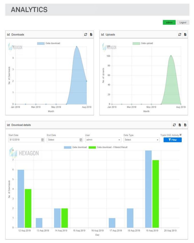
Advanced Logging Charts
ERDAS APOLLO 2020 has greatly
improved the user reporting and visual
reporting of the existing detailed logging
across the server. There are now
general Upload and Download charts
that allow administrators to see how
often data is being ingested and used.
Administrators can now also see
detailed usage in the following ways:
• Date Range: Using the date
controls, a user can see what
uploads or downloads have
occurred within the given range.
• By User: Using the user control, a
user can see how many datasets
are being uploaded and/or
downloaded by a given user.
• By Data Type: Using the data
control, a user can see how many
datasets of a given data type
(imagery, vector, point cloud, etc.)
are being uploaded and/or
downloaded.
All of these can be combined to
determine combinations of information
such as “what data types a given user
has uploaded within a given date range.”
Not only can this be presented in charts
on a web interface, but all of this
information can be exported to a PDF or Excel file to provide reports to management. These reports are
configurable with a logo as well as which properties appear in the Excel spreadsheet.
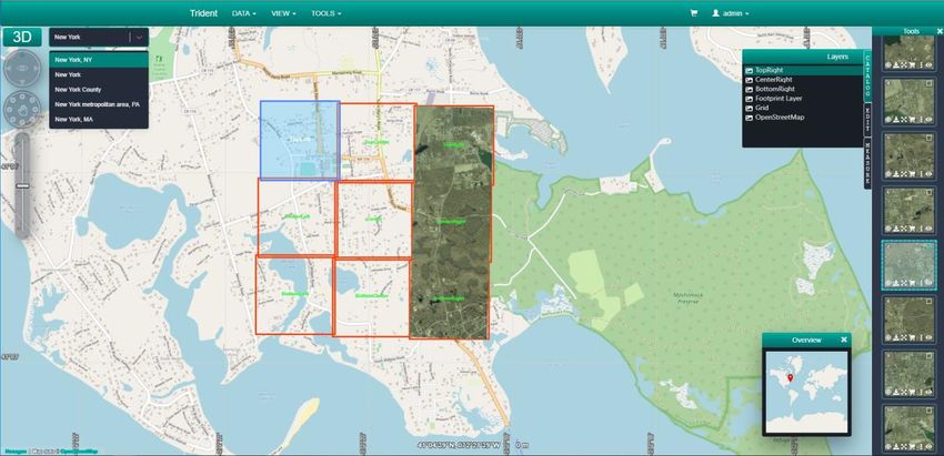
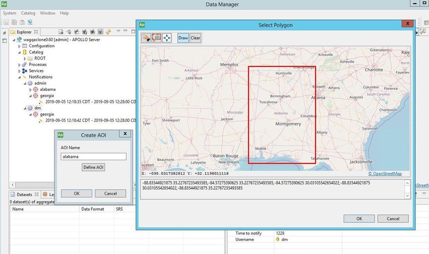
AOI Notification Service
ERDAS APOLLO 2020 now provides a capability for users to register defined areas of interest and receive a
notification email when new data arrives, or existing data is updated that meets their requirements. Only
someone with admin role can register a user and create a notification region. However, any registered user in
the system can be have a notification region created for them.
14 October 2019 5Notifications will be published once a day, but the user may specify the preferred time they would like to
receive emails. When a notification is received, the user must have Data Manager access rights and access to
the datasets based on their credentials to view any new or updated data. Therefore, it is possible to receive a
notification regarding new data, but still not be able to view it. However, we hope to extend this capability to the
new web client in the future to allow more access to users.
The access to this service has been defined and exposed as RESTful APIs and is available to be included
within other clients.
This is an important new feature for customers with large catalogs and want to be proactive informing users in
a self-service environment.
ECWP Browser Streaming Lives Again
Although the Enhanced Compression Wavelet Protocol (ECWP) has been valid for desktop systems since
browsers discontinued plugin support, our previously deprecated Browser Plugin has been a commonly
requested demand from many customers. Good news! Browser technology called WebAssembly combined
with HTML5 webworkers, have now allowed us to revive ECWP for browser-based clients.
• Cross-platform browser support with the need for plugins
• Fast and interactive for users
• Minimal to no overhead on the server
• The heavy lifting is off-loaded to the client
There are some limitations initially. This capability will only support streaming ECW files, but JPEG2000 will be
coming later. Google Chrome and Firefox remains the only supported browsers.
The ECWP WebAssembly decoder brings several advantages as well:
• Seamless network speed adaptation due to progressive rendering
14 October 2019 6• 100% Offline is possible with blocks already downloaded in the wavelet pyramid
• Client-side image processing functions can be built working on the data, not a portrayal of the data (JPG)
• Reuses the existing delivery method from ERDAS APOLLO but now opens up to browser clients
The new Catalog Client will be the first implementation of the new ECWP technology.
Cloud Optimized ECW
ERDAS APOLLO introduced initial support for AWS S3 in its Update 3 Minor Release. But the implementation
was generic across formats and particularly sub-optimal when it came to reading ECW files. ERDAS APOLLO
2020 introduces new optimizations including:
• New async file I/O handlers to obtain higher throughput when interacting with object-based storage systems like
AWS S3
• Reduction in I/O requirements offering potentially significant cloud storage savings on access costs
• Permit client-side visualization through WebAssembly with progressive rendering
• Server-side rendering >30% faster than equivalent Cloud Optimized GeoTIFF (COG) file
• Requires no changes to the ECW File format itself.
Other Improvements
Additional notable updates include:
• ERDAS APOLLO Core’s out-of-the-box configuration is now 15% faster than 2018
• TIFF output format is now supported via the Core service endpoints
• Security enhancements and library updates to resolve several potential security vulnerabilities
• The Core Console now displays Sub-Dataset descriptions as well as Band descriptions to make advanced file
type configuration far easier
• The Data Manager application has gone through several upgrades for this release.
14 October 2019 7• Supports Java 11 versions
• Java is no longer delivered as part of Data Manager and will run on Oracle JDK or OpenJDK
• Drag and drop is supported for crawling by dragging a file or folder on the aggregate in which to crawl
the dataset
• Now a fully 64-bit application
14 October 2019 8System Requirements
ERDAS APOLLO
ERDAS APOLLO Essentials ERDAS APOLLO Advantage &
Professional
Computer/ Processor Intel® or AMD® quad-core processor with a clock speed of 2.0 GHz or higher
Memory (RAM) 8 GB or higher (16 GB recommended)
Server Disk Space 4 GB for application footprint
Spatial Data Storage High Speed Disk Storage, >15000 RPM, SSD, RAID Arrays, or External SAN/NAS 1
Server Operating Systems • Windows Server® 2016 • Windows Server 2016
• Windows Server 2019 • Windows Server 2019
• Red Hat® Enterprise Linux® 7.x
• CentOS 7.x
Cloud Environments Amazon Elastic Cloud Compute (EC2)
Supplementary Operating Windows® 8 or higher can be used for development purposes, but deployments must be done on
Systems for Testing & supported Server Operating Systems listed above.
Development
Software • Microsoft® .NET Framework 4.7 or higher
• Latest Java 8 or Java 11 LTS versions
Licensing Geospatial Licensing Administrator 2020
Application Servers • Microsoft® IIS 10 or higher (Windows)
• Tomcat® 8.5 (embedded in installer)
• Apache® 2.4 or higher (Linux)
Databases • SQLite (Essentials only)
• Oracle® Database 12c (12.1.0.1), Standard or Enterprise Edition
• Microsoft SQL Server® 2017 Express or Standard or Enterprise Edition (Express Edition
should be used for testing & development purposes only)
• PostgreSQL® version 9.6 or higher (with PostGIS 2.0 extension)
• PostgreSQL version 10.8 or higher (with PostGIS 2.0 extension)
Admin Tools ERDAS APOLLO Core Console • ERDAS APOLLO Data Manager
• ERDAS APOLLO Style Editor
(embedded in installer)
14 October 2019 9Compatible Client • Modern ERDAS APOLLO/LuciadFusion Web Client 2020
Applications • Geospatial Portal 2020 (embedded in installer)
• ERDAS APOLLO 2020 Catalog Web Client (embedded in installer)
• GeoMedia® 2020
• GeoMedia Viewer 2020
• GeoMedia Professional 2020
• ERDAS IMAGINE® 2020
• Esri® ArcGIS® for Desktop plugin
• ECWP-enabled applications
• OGC-compliant WMS, WMTS, WCS, WPS client applications
Admin Tools Operating • Windows 8
Systems • Windows 10
• Windows Server 2016
• Windows Server 2019
• RHEL / CentOS v8.x (Essentials only)
14 October 2019 10Issues Resolved
ERDAS APOLLO Core 2020
Issue # Summary
IW-6398
DatabaseUpgrader with configuredatabase param creates wrong encoded connection string
00049425
IW-6396
Implement bbox JSON parsing from ArcPY requests to our GeoServices interface
00049549
IW-6395
ERDAS APOLLO Core - config.xml file was rewritten when there is no disk space
00049423
IW-6376 ERDAS APOLLO Core 16.5 update 3/4: WMS shows no bounding box when based on multiple virtual
00048619 folders
IW-6294
Unable to disable FeatureInfo from WMTS getcapabilities
00044728
IW-6273 Add the subimage descriptions to the console UI
IW-6259
Image size will not be updated in ERDAS APOLLO Core Console
00043434
IW-6230 Remove the old samples from the installer
IW-6225 Database upgrader - TableMigrater
IW-6224 Remove -1 in Physical Folder Table
IW-6216
WMS for ERDAS APOLLO-Catalog not working properly
00041211
IW-6211 Do not call euclideon udSDK unless filetype supports it
IW-6208 Investigate the File Locking in sqlite v3
IW-6200 Web API documentation for 2018 is incorrect
IW-6195 Error messages in ERDAS APOLLO Core.log when crawling a file
00040831 (com.intergraph.imagine.spatialmodeler)
IW-6192
Unable to create new service
00040777
IW-6190 Increase the idle timeout for fcgi installs
IW-6180
ERDAS APOLLO Core Console doesn't find the OpenJDK installed
00039985
IW-6152 Installer minimum requirements shows outdated IIS and .NET version
IW-6149 Corruption of PhysicalFile + PhysicalSubFile indexes after upgrade
IW-6138
ERDAS APOLLO Core will crash on startup if the dump folder location is null
00038842
IW-6137 ERDAS APOLLO Core no longer reporting crash dumps on startup
IW-6130 Issue with QGIS consuming out WMS LegendURL
IW-6102
ERROR Information in ERDAS APOLLO Core-SMSDK.log
00037184
14 October 2019 11IW-6091 Expose band descriptions in styling dialog for improved hyperspectral configuration
IW-6065 Add temporal support to the WMTS REST interface
IW-6063 Configure wizard crashes if the quote the SQLite database
IW-6061 Miscellaneous naming changes
IW-6060 Add RPM GPG signing to ERDAS APOLLO Core Linux
IW-6058 ERDAS APOLLO Core Linux is crashing
IW-6051
Statistics error when working with virtual mosaic dataset
00035722
IW-6048 ERDAS APOLLO Core Linux restarted unexpectedly
IW-6034 Upgrade Qt to 5.12 LTS before release
IW-6025 User credentials for SQL Server being logged
IW-6019 Verify Windows Server 2019 support
IW-6017 Update looks.jar on Linux, and use system one on Windows
IW-5997 Configuration Wizard does not support quotes in user inputs for Oracle
IW-5990 ERDAS APOLLO Core CustomCredentialsPage config wizard page not shown
IW-5981 In-memory cache can become out-of-sync with database (add/remove folders)
Modifying capabilities name then copying the dataset within the service will cause cache to become out
IW-5972 of sync with database
IW-5967 Improve statistics endpoint error when statistics are not configured
IW-5963 Statistics fails for SampleIWS_images_temporal when viewing WMS-T Time series sample
IW-5953 UI Improvements to New File/Folder Dialog Boxes
IW-5946 EcwpMgr API should not allow enabling watch dir on folders
IW-5945 Linux: Connection issues with Apache and ERDAS APOLLO Core
IW-5940 Replace Intel Performance Primitives (IPP) JPEG encoder/decoder with libjpeg-turbo in GDAL
Investigate crash dumps in WMS GetMap when Advanced Security is enabled and Oracle DB in
IW-5934
PorkyPig is used
IW-5931 Server should log and shutdown gracefully if the config file is invalid
IW-5907 Input credentials for Advanced Security authentication will not add inputs to request in CentOS 7
IW-5902 Pop-up window in renaming folder is labeled dataset name
IW-5899 ImageX requests from the console don't encode plus signs
IW-5894 ERDAS APOLLO Core will not run in Ubuntu 16 & 17
IW-5882 Some datasets don't advertise native footprint in dsinfo
IW-5855 Reprojection error with ImageX when Imagchain is applied and SRS is not specified in a specific tiff file
IW-5810 Removing required parameters for WMS 1.1.1 GetCapabilities should return an error message
IW-5802 Drag and Drop a folder with datasets to a new service does not work
IW-5736 Capabilities open twice when selected in console
IW-5702
Esri Geoservices fails to load to ArcMap
00026397
IW-5658 Investigate ways to improve the system test configuration workflow
14 October 2019 12IW-5607 WMS request with invalid missing service is allowed
IW-5601 Warnings log when using advanced security
IW-5587 Errors logged on Linux during startup
IW-5494 set_and_return_info does not work for the default case
IW-5340 Systemtest: Image chain reference images has changed
IW-5325 Upgrade systemtest to latest databases
IW-5313 Add STYLEPARAMS example link to Styling Dialog
IW-5150 Invalid ERS files results in ERDAS APOLLO Core hanging
IW-5098 Reduce the amount of projection error/fatal log entries
IW-5075 ERDAS APOLLO Core has unexpressed dependency on X11
IW-5058 SystemTest: Create tests for WMTS RESTful interface
IW-5017 Add dynamic compression to ERDAS APOLLO Core Linux
IW-4958 Create system tests for database upgrader
IW-4926 (Technical debt)Fix database upgrader to avoid future upgrading requires existing upgrade changes
IW-4902 Prepare build infrastructure to move to MSVC141 (Visual Studio 2017)
IW-4856 Core Linux with an Oracle database produces different PNGs
IW-4838 Re-investigate database performance
IW-4829 Submit our Qt changes back to Qt
IW-4733 Coordinate with ERDAS IMAGINE for upgrade Qt to v5.x
IW-4610 Not able to load nitf images into ECW Browser plugin
IW-4582 Server enters infinite loop adding mislabelled ERS file
IW-4487 Console does not complain if you rename datasets to something existing
IW-4430 Error in projecting subimage in Linux
IW-4380 Remove the .bin install requirement to run as root
IW-4323 Upgrade Lizardtech DSDK to v9.5.1.4427
IW-4314 Support .aux files natively in Essentials
IW-3523 Implement CORS headers
IW-3467
Improve LegendURL configuration
00038363
IW-3201 AE Linux: Configuration settings are not persisted when server restarts
IW-3173 Links on Example pages inacurate
IW-3163 Add offline mode to browser plug-in
IW-3082 Re-selecting streamable JP2 sub image disables ECWP
IW-3026 Postinstall.sh assumes apache will always be httpd
IW-2903 Disable WMTS entirely for EPSG:0/WGS84 local datasets
IW-2893 WMS/WMTS rendering of UDS files very slow for dense point clouds
IW-2701 Invalid ERS hangs / crashes server
IW-2501 On Linux, JSViewProxy call to query pixel values will result in a "libpng error: Read Error"
14 October 2019 13IW-2432 ERDAS ECW plugin method to "lock extents"
IW-2431 Linux: Imagery from OTDF file contains image artifacts (grey bars)
IW-2426 Background colour changes when viewing sample ADS-80_v3.ecw dataset.
IW-2008 Document how to create an OTDF file that aligns with the well-known tile matrix set
IW-1552 Digitally sign ERDAS APOLLO Essentials linux installer
IW-1375 The watermarking "Open File" button should be disabled from non-localhost connections.
IW-1352 Add jpegxr configuration parameters to the console
IW-1332 CreateView method would fail in Firefox
IW-1322 JPIP doesn't work over IPv6
IW-1229 Incorrect initial extents when setting geolinking mode
IW-1190 Local disk cache location not set until config window is closed
IW-1098 ECWP browser plugin installation directory name to be changed from ERDAS to Intergraph
IW-713 Mouse wheel in html example on Firefox does not work correctly
IW-435 Add web monitoring tool
ERDAS APOLLO Advantage/Professional 2020
Issue # Summary
AP-11051 Modify clip zip ship rest api to allow download of files without zip
AP-11047
Geoprocessed dataset owner is always "admin" for geoprocessing
00049785
AP-11045 Update WMS_MS_Capabilities.dtd for legacy WMS 1.1.1 OGC CITE Tests
AP-11037 Unnecessary ERDAS APOLLO ports need to be closed
AP-11034
00049898
Custom objects crawling functionality
00047190
00048689
AP-11031 Portal loses user authorization when trying to display a WMTS
AP-11015
Configwizard crashes when using United States-International keyboard (INTL)
00044915
AP-10999 Port setting not updated in web.config files when switching to/from SSL
AP-10993
ERDAS APOLLO generate wrong BBOX for aggregate with PDF document
00042759
AP-10992 Updates to ERDAS APOLLO Upload/Download Analysis
AP-10991
00042387
Portal issue in CZS with a geographic CRS and EPSG:3857
00043079
00042595
14 October 2019 14AP-10988
PostGIS based WFS returns error if outputformat=shapefile
00042483
AP-10985
00042385 Missing legend graphic on Map Content->Layers
00040794
AP-10982
Documentation update needed for DataManager.ini
00041484
AP-10981
Re-run ERDAS APOLLO config wizard overwrite HTTPs and public-facing setting @ web.config files
00041490
AP-10971 Data manager vector database crawling job disappear even there is a lot ERROR in decodingservice
00041000 log file
AP-10963 LOG_ENTRY TABLE - Issues with Spatial Query from Portal when using large amount of geometry
00040729 points
AP-10958
ERDAS APOLLO 2018 Update 2 Handling of jobs is throwing ERROR Messages
00040292
AP-10956
Geoprocessing input cannot be optional
00040081
AP-10953
Issues with REST API for crawling files in Cluster
00037143
AP-10952 Disabling the download permission doesn't work on documents ("Enable Download Service" set to false
00039936 doesn't work on documents)
AP-10933
Failed to crawl mpeg video
00038764
AP-10930 Enhance the Advanced Logging Reports
AP-10928 JDK compatibility Update
AP-10922
Limit the number of queryable to 15
00037631
AP-10917 getLayer link available for any register WMS
AP-10916
00040837 Unable to see Arabic characters via vector services in ERDAS APOLLO via WMS GetFeatureInfo
00038209
AP-10915 "No Inspector found" error for Uniform Roads , DiscreteRoadClassification, Range Road Classification
00037753 styles (legacy vector style editor)
AP-10914 Multiband Image Processing is slowed down greatly by opening all the bands
AP-10905 Datum/J2 customer issues
AP-10886
00037753
Making a getFeatureInfo on more than 1 layer returns you only one answer and without the layer name
00037368
00037379
AP-10885 Layer name missing from the getFeatureInfo response - ApolloCatalogWMS in Portal
AP-10864 Remove Java 1.7 dependency from Data Manager
AP-10841 Implement Rest API for AOI Notifications
14 October 2019 15AP-10821
EHCACHE setting for Apollo Cluster with multibple Networtinterfaces
00034075
AP-10759
apollo-portal: ISO Metadata does not show thumbnail
00031402
AP-10742
Tomcat crashes, vector legacy services
00022785
AP-10707 Administration Console > User Maps & Workflows, creates "invalid token" error with Windows
00030640 Authentication
AP-10676
ERDAS APOLLO failed to crawl Aster (HDF) images
00029720
AP-10640
ERDAS APOLLO (legacy WMS) failed to display float double image (even after create raster style)
00038816
AP-10538 .hdf files fail during crawl
AP-10359
Shift for cataloged vector data (ESPG:5235)
00023045
AP-10317
Error Crawling SQL Server DB
00022774
AP-10294 AvailabilityDate property is not getting updated as expected with services/rpc test
AP-10229 Upgrade log4j from 1.2.14 to 1.2.17
AP-10223
Datasets (images) having Thai names are not working! The images are not displayed correct.
00022395
AP-10182
Geospatial Portal - Clip-ship-zip fails if all bands are deselected
00022146
AP-10180
Clip-Ship-Zip - second email not sent when CZS failed
00022119
AP-10120 ERDAS APOLLO is locking files after the crawling
AP-9860
ERDAS APOLLO WPS geoprocessing output cleanup doesn't work at all
00020945
AP-9690
Document Tomcat Delayed Start option if license service is also on the ERDAS APOLLO server
00014481
AP-9017
00036002 Be able to control what user/role can do CZS/download @ Apollo portal
00028926
AP-1433 Need to document patterns used for tables when creating the mapping xml
Geospatial Portal 2020
Issue # Summary
SR-6451 There is no Welcome Page for Geospatial SDI
SR-6450 Setup Manager is no updated after installing any of WebGIS product
SR-6448 Missing Features Window in GWM Config Wizard has less features name than from previous cycle
14 October 2019 16SR-6438 Error and warning in Webmap Configuration Wizard and Admin Console Service
SR-6437 Small translation mistake on WebMap installer in polish OS
SR-6414 WFS features with line type are not highlighted
SR-6413 Measure area functionality enables measurement of incorrectly drawn surface geometry
SR-6412 Adapt SDI Tools to build both .NET 4.7.2 and 4.0 assemblies
SR-6410 Move ChannelFactoryHelper class to sdi-tools
SR-6409 Allow Admin Console to configure WMPS searchers for Consumer Portal for HTTPS
SR-6400
$GP.dynamicFeatureEvents don't work with WMPS
00051504
SR-6399 Introduce the upgrade paths mechanism for Consumer backend, BackendWMPS and WMPS services
SR-6391 Save Map option is not visible in Admin Portal on polish OS version
SR-6377 Adapt WMPS bindings configuration to handle reliableSession in HTTP only
SR-6376 Transfer the binding creation mechanism from the Portal to the Consumer Backend
SR-6356 No results on WFS-G search in Geospatial Portal instance
SR-6354 WFS 16.6 cannot be displayed on Consumer Portal 16.6
SR-6324 The "consumer-backend-16.6.5-template.zip" artifact is created without all the required files
Adding new Map Server Pool in the Administration Console doesn't increase number of MapSrv
SR-6323
Modules processes.
No possibility of configuring Geospatial Portal and WebMap Publisher Portal instances. using
SR-6303
AdminConsole
SR-6251 Errors during the AdminPortal upgrade
SR-6249 Wrong MapSvrMngr.exe interopin sdi-services dependency
SR-6245 Wrong versioning scheme of WebMap .NET dlls (COM and COM Interop possibly)
SR-6244 Force recreation of *.aspx.designer.cs files for GWMPub.aspx and Mobile.aspx
SR-6243 WMS Basic Originating Pipe's WMS web.config template wrong attribute case
SR-6238 Error in the GeoMedia WebMap Configuration Test - A valid license is not found
SR-6188 MapSvr.exe is not registered correctly
SR-6187 Errors in Administration Console Service log
SR-6161 PSS features are not returned until Portal page is refreshed
SR-5904 Fix inter-module dependencies in full-portal-template-msm
SR-5313 Unable to add Personal Layer feature class in MapWithToolbar.aspx
14 October 2019 17Contact Us
https://go.hexagongeospatial.com/contact-us-today
About Hexagon
Hexagon is a global leader in sensor, software and autonomous solutions. We are putting data to work to
boost efficiency, productivity, and quality across industrial, manufacturing, infrastructure, safety, and mobility
applications.
Our technologies are shaping urban and production ecosystems to become increasingly connected and
autonomous — ensuring a scalable, sustainable future.
Hexagon’s Geospatial division creates solutions that deliver a 5D smart digital reality with insight into what
was, what is, what could be, what should be, and ultimately, what will be.
Hexagon (Nasdaq Stockholm: HEXA B) has approximately 20,000 employees in 50 countries and net sales of
approximately 4.3bn USD. Learn more at hexagon.com and follow us @HexagonAB.
14 October 2019 18Copyright
© 2019 Hexagon AB and/or its subsidiaries and affiliates. All rights reserved. Hexagon has registered
trademarks in many countries throughout the world. Visit the Trademarks Page for information about the
countries in which the trademarks are registered. See Product Page and Acknowledgments for more
information.
Product Documentation Terms of Use
PLEASE READ THESE TERMS CAREFULLY BEFORE USING HEXAGON GEOSPATIAL’S
DOCUMENTATION ("DOCUMENT"). USE OF THIS DOCUMENT INDICATES ACCEPTANCE OF THIS
AGREEMENT WITHOUT MODIFICATION. IF YOU DO NOT AGREE TO THE TERMS HEREOF ("TERMS"),
DO NOT USE THIS DOCUMENT.
Use Of This Document
All materials in this Document are copyrighted and any unauthorized use may violate worldwide copyright,
trademark, and other laws. Subject to the terms of this Agreement, Hexagon Geospatial (a Division of
Intergraph Corporation) and Intergraph’s subsidiaries ("Intergraph") hereby authorize you to reproduce this
Document solely for your personal, non-commercial use. In consideration of this authorization, you agree to
retain all copyright and other proprietary notices contained therein. You may not modify the Materials in any
way or reproduce or publicly display, perform, or distribute or otherwise use them for any public or commercial
purpose, except as specifically authorized in a separate agreement with Hexagon Geospatial.
The foregoing authorization specifically excludes content or material bearing a copyright notice or attribution of
rights of a third party. Except as expressly provided above, nothing contained herein shall be construed as
conferring by implication, estoppel or otherwise any license or right under any copyright, patent or trademark of
Hexagon Geospatial or Intergraph or any third party.
If you breach any of these Terms, your authorization to use this Document automatically terminates. Upon
termination, you will immediately destroy any downloaded or printed Materials in your possession or control.
Disclaimers
ALL MATERIALS SUPPLIED HEREUNDER ARE PROVIDED "AS IS", WITHOUT WARRANTY OF ANY
KIND, EITHER EXPRESSED OR IMPLIED, INCLUDING, BUT NOT LIMITED TO, ANY IMPLIED
WARRANTIES OF MERCHANTABILITY, FITNESS FOR A PARTICULAR PURPOSE, OR NON-
INFRINGEMENT. Hexagon Geospatial does not warrant that the content of this Document will be error-free,
that defects will be corrected, or that any Hexagon Geospatial Website or the services that make Materials
available are free of viruses or other harmful components.
Hexagon Geospatial does not warrant the accuracy and completeness of this Document. Hexagon Geospatial
may make changes to this Document at any time without notice.
Limitation Of Liability
IN NO EVENT SHALL HEXAGON GEOSPATIAL BE LIABLE FOR ANY DIRECT, INDIRECT, INCIDENTAL,
SPECIAL OR CONSEQUENTIAL DAMAGES, OR DAMAGES FOR LOSS OF PROFITS, REVENUE, DATA
OR USE, INCURRED BY YOU OR ANY THIRD PARTY, WHETHER IN AN ACTION IN CONTRACT OR
TORT, ARISING FROM YOUR ACCESS TO, OR USE OF, THIS DOCUMENT.
Indemnification
You agree to defend, indemnify, and hold harmless Hexagon Geospatial, its officers, directors, employees, and
agents from and against any and all claims, liabilities, damages, losses or expense, including reasonable
attorneys' fees and costs, arising out of or in any way connected with your access to or use of this Document.
Use Of Software
14 October 2019 19Use of software described in this Document is subject to the terms of the end user license agreement that
accompanies the software, if any. You may not download or install any software that is accompanied by or
includes an end user license agreement unless you have read and accepted the terms of such license
agreement. Any such software is the copyrighted work of Hexagon Geospatial, Intergraph or its licensors.
Portions of the user interface copyright 2012- Telerik AD.
Links To Third Party Websites
This Document may provide links to third party websites for your convenience and information. Third party
websites will be governed by their own terms and conditions. Hexagon Geospatial does not endorse
companies or products to which it links.
Third party websites are owned and operated by independent parties over which Hexagon Geospatial has no
control. Hexagon Geospatial shall not have any liability resulting from your use of the third party website. Any
link you make to or from the third party website will be at your own risk and any information you share with the
third party website will be subject to the terms of the third party website, including those relating to
confidentiality, data privacy, and security.
Trademarks
The trademarks, logos and service marks ("Marks") displayed in this Document are the property of Hexagon
Geospatial, Intergraph or other third parties. Users are not permitted to use Marks without the prior written
consent of Hexagon Geospatial, Intergraph or the third party that owns the Mark. "Intergraph" is a registered
trademark of Intergraph Corporation in the United States and in other countries. Other brands and product
names are trademarks of their respective owners.
Find additional trademark information http://www.hexagongeospatial.com/legal/trademarks.
Procedure For Making Claims Of Copyright Infringement
Notifications of claimed copyright infringement should be sent to Hexagon Geospatial by mail at the following
address: Intergraph Corporation, Attn: Intergraph Legal Department, P.O. Box 240000, Huntsville, Alabama
35824.
US Government Restricted Right
Materials are provided with "RESTRICTED RIGHTS." Use, duplication, or disclosure of Materials by the U.S.
Government is subject to restrictions as set forth in FAR 52.227-14 and DFARS 252.227-7013 et seq. or
successor provisions thereto. Use of Materials by the Government constitutes acknowledgment of Hexagon
Geospatial or Intergraph’s proprietary rights therein.
International Use
You may not use or export Materials in violation of U.S. export laws and regulations. Hexagon Geospatial
makes no representation that Materials are appropriate or available for use in every country, and access to
them from territories where their content is illegal is prohibited.
Hexagon Geospatial provides access to Hexagon Geospatial international data and, therefore, may contain
references or cross references to Hexagon Geospatial products, programs and services that are not
announced in your country. These references do not imply that Hexagon Geospatial intends to announce such
products, programs or services in your country.
The Materials are subject to U.S. export control and economic sanctions laws and regulations and you agree
to comply strictly with all such laws and regulations. In addition, you represent and warrant that you are not a
national of, or otherwise located within, a country subject to U.S. economic sanctions (including without
limitation Iran, Syria, Sudan, Cuba, and North Korea) and that you are not otherwise prohibited from receiving
or accessing the Materials under U.S. export control and economic sanctions laws and regulations. Hexagon
Geospatial makes no representation that the Materials are appropriate or available for use in every country,
14 October 2019 20and access to them from territories where their content is illegal is prohibited. All rights to use the Materials are granted on condition that such rights are forfeited if you fail to comply with the terms of this agreement. Revisions Hexagon Geospatial reserves the right to revise these Terms at any time. You are responsible for regularly reviewing these Terms. Your continued use of this Document after the effective date of such changes constitutes your acceptance of and agreement to such changes. Applicable Law This Document is created and controlled by Hexagon Geospatial in the State of Alabama. As such, the laws of the State of Alabama will govern these Terms, without giving effect to any principles of conflicts of law. You hereby irrevocably and unconditionally consent to submit to the exclusive jurisdiction of the United States District Court for the Northern District of Alabama, Northeastern Division, or the Circuit Court for Madison County, Alabama for any litigation arising out of or relating to use of this Document (and agree not to commence any litigation relating thereto except in such courts), waive any objection to the laying of venue of any such litigation in such Courts and agree not to plead or claim in any such Courts that such litigation brought therein has been brought in an inconvenient forum. Some jurisdictions do not allow the exclusions or limitations set forth in these Terms. Such exclusions or limitations shall apply in all jurisdictions to the maximum extent allowed by applicable law. Questions Contact us with any questions regarding these Terms. 14 October 2019 21
You can also read