Report on Achievements in Flood Protection in the Danube River Basin - IC-159
←
→
Page content transcription
If your browser does not render page correctly, please read the page content below
Report on Achievements
in Flood Protection in the
Danube River Basin

                                                                                          Document number: IC-159
                                                                                                   Version: 2010
                                                                                                      Date: 22-Nov-2010

ICPDR / International Commission for the Protection of the Danube River / www.icpdr.org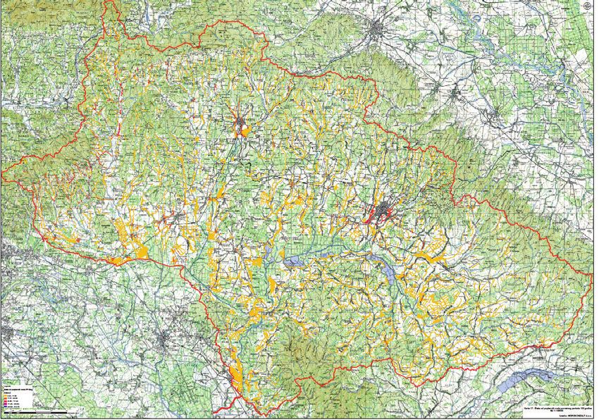
Imprint

Published by:
ICPDR – International Commission for the Protection of the Danube River

© ICPDR 2010

Contact
ICPDR Secretariat
Vienna International Centre / D0412
P.O. Box 500 / 1400 Vienna / Austria
T: +43 (1) 26060-5738 / F: +43 (1) 26060-5895
icpdr@unvienna.org / www.icpdr.org

ICPDR / International Commission for the Protection of the Danube River / www.icpdr.org
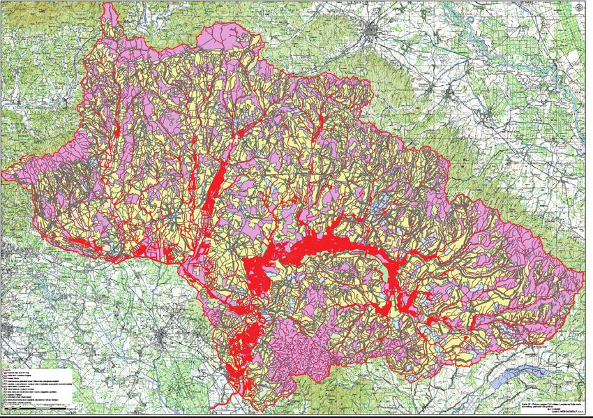
Table of content

1 Introduction                                                                                      4

2 Development and Improvement of Flood Forecasting and Early Warning System                        6
    2.1Danube EFAS                                                                                  6
    2.2Report on Assessment of Flood Monitoring And Forecasting in the Danube River Basin           6

3 Preparation of flood action plans in sub-basins                                                   7

4 Major achievements in flood risk management in Danube countries                                   7
    4.1Existing framework for transboundary cooperation                                             7
    4.2Major developments in flood risk management                                                  9
    4.2.1Germany – Bavaria & Baden-Wuerttemberg                                                     9
    4.2.2Austria                                                                                   10
    4.2.3Czech Republic                                                                            12
    4.2.4Slovakia                                                                                  18
    4.2.5Hungary                                                                                   22
    4.2.6Slovenia                                                                                  24
    4.2.7Croatia                                                                                   26
    4.2.8Serbia                                                                                    29
    4.2.9Bosnia and Herzegovina                                                                    31
    4.2.10Romania                                                                                  35
    4.2.11Bulgaria                                                                                 37
    4.2.12Ukraine                                                                                  39

5 Creating Forums for Exchange of Expert Knowledge                                                 42
    5.1Document on Coordination aspects of EFD implementation in the Danube River Basin            42
    5.2Other information sources                                                                   43

6 Recommendation for a common approach in assessment of flood-prone areas and evaluation of
flood risk 43
    6.1Status review and report of flood mapping and flood risk evaluation in the sub-basins and
    countries of the Danube River Basin                                                            43
    6.2Minimum recommendations for flood risk mapping in the Danube River Basin                    44
    6.3FLOODRISK project                                                                           44

7 Other activities                                                                                 45
    7.1Danube 2006 floods report                                                                   45
    7.2Flood factsheet 2010                                                                        46

8 Conclusions                                                                                      47

ICPDR / International Commission for the Protection of the Danube River / www.icpdr.org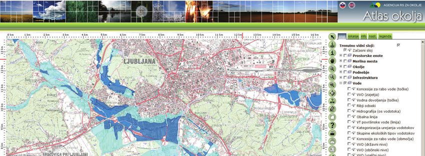
Report on Achievements in FP 4

1 Introduction
In response to the danger of flooding and in line with its Joint Action Programme, the ICPDR decided
in 2000 to establish the long-term Action Programme for Sustainable Flood Prevention in the Danube
River Basin. The whole process was accelerated after disastrous floods in 2002 and resulted in
adoption of the Action Programme at the ICPDR Ministerial Meeting on 13 December 2004.
This Action Programme is based on the sustainable flood protection programmes developed in the
various Danube countries as well as on networking existing structures and using the future-oriented
knowledge base accumulated through a wide range of activities over the past decade. The overall goal
of the Action Programme is to achieve a long term and sustainable approach for managing the risks of
floods to protect human life and property, while encouraging conservation and improvement of water
related ecosystems. Given the area, the complexity and the internal differences in the Danube River
Basin, the Action Programme represents an overall framework, which needs to be specified in further
detail for sub-basins. The Action Programme is based on UN-ECE Guidelines on Sustainable Flood
Prevention, EU Best Practices on Flood Prevention, Protection and Mitigation and on EU
Communication on flood risk management, COM(2004)472. The major principles advocated are: (i)
the shift from defensive action against hazards to management of the risk and living with floods (ii)
the river basin approach taking into account the Water Framework Directive, (iii) joint action of
government, municipalities and stakeholders towards flood risk management and awareness raising,
(iv) reduction of flood risks via natural retention, structural flood protection and hazard reduction, and
(v) solidarity.
Targets of the Action Programme are set on a basin-wide and a sub-basin level taking into account the
above-mentioned principles. There are four major basin-wide targets, which are currently under
implementation:
(i)      Improvement of flood forecasting and early flood warning system
         Interlinking of the national and/or regional systems aims to improve the overall coordination
         and transboundary coherence of flood monitoring and forecasting systems. In parallel to
         interlinking of national systems a Danube Flood Alert System was developed by the EC JRC
         and was launched in December 2007.
(ii)     Support for the preparation of and coordination between sub-basin-wide flood action plans
         The ICPDR is a coordination platform for preparation of flood action plans for the river sub-
         basins. Steps towards linking of flood risk management with the river basin management have
         been done in cooperation with the river basin managers in the Danube countries.
(iii)    Creating forums for exchange of expert knowledge
         Measures should be taken towards sharing of experience and coordinated development and
         promotion of best practices on flood risk management. Exchange of relevant information on
         flood protection, prevention and mitigation with the other international river commissions is
         foreseen.
(iv) Recommendation for a common approach in assessment of flood-prone areas and evaluation of
     flood risk
        The overall approach of the EU Directive on the assessment and management of flood risks
        towards flood risk mapping is coherent with the basic principles described in the ICPDR Action
        Programme on Sustainable Flood Protection in the Danube River Basin.

ICPDR / International Commission for the Protection of the Danube River / www.icpdr.org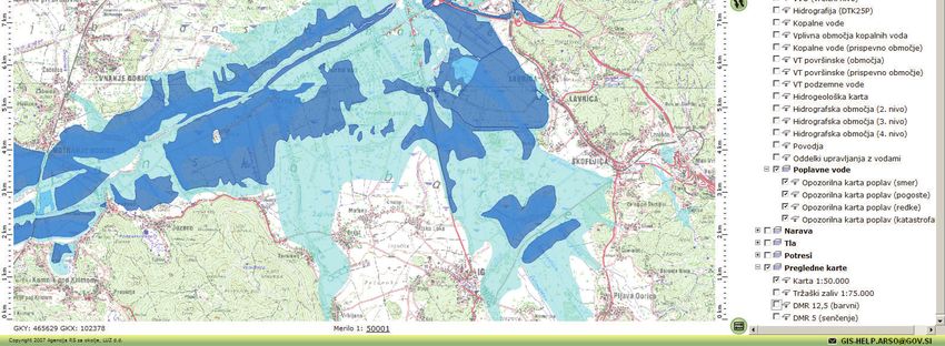
Report on Achievements in FP 5

In September 2007 a Directive of the European parliament and of the Council on the assessment and
management of flood risks was finally adopted by the European Council. The aim of the Directive is
to reduce and manage the risks that floods pose to human health, the environment, cultural heritage
and economic activity. The Directive requires Member States to first carry out a preliminary flood risk
assessment by 2011 to identify areas at risk of flooding. For such areas they would then need to draw
up flood risk maps by 2013 and establish flood risk management plans focused on prevention,
protection and preparedness by 2015. The Directive applies to inland waters as well as all coastal
waters across the whole territory of the EU. The Directive shall be carried out in coordination with the
Water Framework Directive, notably by flood risk management plans and river basin management
plans being coordinated, and through coordination of the public participation procedures in the
preparation of these plans. All assessments, maps and plans prepared shall be made available to the
public. Member States shall furthermore coordinate their flood risk management practices in shared
river basins, including with third counties, and shall in solidarity not undertake measures that would
increase the flood risk in neighbouring countries. Member States shall take into consideration long
term developments, including climate change, as well as sustainable land use practices in the flood risk
management cycle addressed in this Directive.
The adoption of the EU Directive on the assessment and management of flood risks (EFD) has its
impact also on the implementation of the ICPDR Action Programme on Sustainable Flood Protection
in the Danube River Basin both in terms of technical content and the implementation time plan, given
that the ICPDR Action Programme itself foresees incorporating the future developments of the EU
flood policy.
In 2009 the ICPDR published 17 sub-basin flood action plans covering the entire Danube catchment.
This was a key milestone set in the ICPDR Action Programme for Sustainable Flood Prevention but
also an important step in a harmonized implementation of the EFD in the Danube River Basin
District.
This Report provides the stakeholders and public with an overview of the achievements in
implementation of the targets of the ICPDR Action Programme on Sustainable Flood Protection in the
Danube River Basin with a particular attention given to the progress made in the sub-basins in
implementation of the action plans as well as of the EU Directive on the assessment and management
of flood risks. Report on Achievements in Flood Protection in the Danube River Basin is structured
according to the four basin-wide targets of the ICPDR Flood Action Programme and it is a living
document, which will be updated regularly with a view of demonstrating to the wide target audience
the efforts made and the progress achieved in the Danube River Basin in the field of flood risk
management.

ICPDR / International Commission for the Protection of the Danube River / www.icpdr.org
Report on Achievements in FP 6

2 Development and Improvement of Flood Forecasting
    and Early Warning System

2.1 Danube EFAS
The European Flood Alert System (EFAS) is being developed at the EC Joint Research Centre (JRC)
with support of the national meteorological services and national hydrological services (NHS). As to
date, around 25 operational authorities across Europe, all together responsible for more than 85% of
the major trans-national river basins, are receiving EFAS information as early flood warning reports
for floods in the next 3-10 days. As for the Danube countries EFAS Memoranda of Understanding
(MoU) have been signed with DE, AT, CZ, SK, HU, SI, RS, RO, BG and MD. Recently HR joined as
well. Negotiations on membership are ongoing with UA and BA. EFAS-Danube members have 24/7
access to a protected web-server where the twice-daily EFAS forecasts can be examined and viewed
(http://efas-is.jrc.ec.europa.eu/efas-forecasting.html ).
In 2010, using further data received from several institutes within the Danube, the calibration of the
5km grid hydrological model version has been redone. Furthermore, EFAS uses now also ensemble
weather forecasts from COSMO-LEPS, which enables higher-resolution forecasts until 5 days before a
flood event, more focussed towards flash flood forecasting. Also, using near-realtime river discharge
data received from Danube water authorities, corrected flood forecasts are currently provided (called
realtime hydrographs on EFAS website). At present, these realtime hydrographs are available for
selected stations in the Upper Danube in Germany, Austria, Czech Republic and Slovakia. Using the
realtime discharge data, also an overview is made where actual flooding is in the Danube as well as
Europe: http://floods.jrc.ec.europa.eu/ongoing-floods.html
Further improvements under development are the use of realtime satellite snow cover data, bias-
correction of rainfall forecasts, use of satellite derived rainfall data, and the use of satellite derived soil
moisture data.
Discussions for the transfer of EFAS to an operational entity are in a final stage with DG ECHO
(Humanitarian Aid) and DG ENTR (Enterprise) in Brussels. EFAS is expected to go into full
operation in Autumn 2011.

2.2 Report on Assessment of Flood Monitoring And Forecasting in the Danube River Basin

The national flood forecasting and warning systems in the Danube River Basin differ in the frequency,
methods and techniques used for monitoring and also in data collection and processing. In some
countries the outdated and advanced methodologies are running in parallel. Therefore the ICPDR
Action Programme on Sustainable Flood Protection in the Danube River Basin aims to develop the
methodology and tools of data collection, processing, forecasting and dissemination where necessary
and also to interlink the regional and national agencies on sub-basin and basin level to facilitate and
promote the exchange of source data and forecasting and warning in transboundary sub-basins.
The first step in this activity was preparation of the Report on Assessment of Flood Monitoring And
Forecasting in the Danube river basin, which was finalized in 2009. The report reviews:
     •    Climatic and hydrological conditions in the DRB
     •    Flood monitoring system
               o    Description of the meteorological network
               o    Description of the hydrological monitoring network
     •    Development of the flood information service for the Danube river basin

ICPDR / International Commission for the Protection of the Danube River / www.icpdr.org
Report on Achievements in FP 7

     •    The role of the European Flood Alert System

3 Preparation of flood action plans in sub-basins
In 2009 the ICPDR published 17 sub-basin flood action plans, based on 45 national planning
documents, and covering the entire Basin. These action plans provide the first ever comprehensive
overview of actions to reduce flood risk in the Danube Basin. In drawing up the plans, measures were
first elaborated at the national level in each of the 13 ICPDR states. Joint discussions between
countries sharing particular sub-basins then took place to create a harmonized plan for the entire area
of each sub-basin.
The finalised action plans review the current situation and set targets and respective measures for
reducing adverse impacts and the likelihood of floods, increasing awareness and level of preparedness
and improving flood forecasting. The targets and measures are based on the regulation of land use and
spatial planning; increase of retention and detention capacities; technical flood defences; preventive
actions (e.g. flood forecasting and flood warning systems); capacity building; awareness and
preparedness raising and prevention and mitigation of water pollution due to floods. The sub-basin
action plans detail comprehensive information on hundreds of concrete actions to reduce flooding
throughout the region, including re-naturalisation of water bodies, creation of flood polders, upgrading
of dykes and improvement of alarm and forecasting systems. As a follow up to the action plans, the
development of flood hazard and flood risk maps is crucial. Decisions related to the implementation of
the action plans are a task and responsibility of the individual countries, according to their national
legislation and bilateral and multilateral agreements.

4 Major achievements in flood risk management in
  Danube countries
This chapter provides an overview of the developments in flood risk management on the national
level.

4.1 Existing framework for transboundary cooperation
Bilateral discussions between Germany and Austria are held in a working group under the standing
water commission according to the “Regensburger Vertrag” (Regensburg Treaty). The working group
agreed to establish the flood action plans for the sub-basins in temporal, organizational and
contentwise coordination with the EU flood directive.
In the Czech Republic bilateral cooperation framework with Slovakia is based on Treaty between the
Government of the Czech Republic and the Government of the Slovak Republic on cooperation on
transboundary watercourses from the year 1999. Cooperation with Austria is based on treaty between
Czechoslovak Socialist Republic and the Austrian Republic on regulation of water management issues
related to border waters from the year 1967.

ICPDR / International Commission for the Protection of the Danube River / www.icpdr.org
Report on Achievements in FP 8

There is an ongoing cooperation of experts involved in the Bilateral commissions on the cooperation
on the border waters in Slovakia. A cooperation framework is established with the Czech Republic,
Austria, Hungary, Ukraine and Poland.
Cooperation framework in Hungary was established in the Pannonian Central Danube sub-basin in the
frame of HU-AT, HU-SK, HU-HR and HU-RS bilateral commissions and in the Drava-Mura sub-
basin in the frame of HU-AT, HU-SI, HU-HR bilateral commissions. In the Tisza River Basin there
is a developing cooperation in the frame of the ICPDR Tisza Working Group, also utilising the
outcomes of the Tisza Forum.
There is an intensive cooperation in the frame of bilateral commissions in place in Slovenia. These
include cooperation on Mura and Drava with Austria, cooperation with Croatia on Drava, Mura and
Sotla-Sava-Kolpa) and the work of bilateral Commission with Hungary.
Transboundary flood protection issues in Croatia are dealt with by the respective sub commissions
established under the umbrella of the bilateral commissions with Slovenia, Hungary and Bosnia and
Herzegovina. Serbia has ongoing bilateral cooperation with Romania and Hungary based on the
existing bilateral agreements, covering the Danube, the Tisa and the Banat regions.
The Permanent Expert Group for Flood Protection (PEG FP) has been established within the
International Sava River Basin Commission (ISRBC), and all Sava countries (Croatia, Slovenia,
Serbia and Bosnia and Herzegovina) participate in its work. This group is now preparing Protocol on
Flood Protection, which will be a ground for future cooperation in flood risk management in the Sava
River basin.

Since its independence in 1991 Ukraine has signed agreements on water management issues related to
transboundary watercourses with Hungary, Romania, Slovakia and Moldova.
                  DE      AT      CZ      SK       HU      SI      HR      BA       RS    BG    RO        MD UA
         DE                 x       x
         AT        x                x       x       x        x
         CZ        x        x               x
         SK                 x       x               x                                                          x
         HU                 x               x                x       x               x            x            x
         SI                 x                       x                x
         HR                                         x        x               x
         BA                                                          x
         RS                                         x                                             x
         BG                                                                                       x
         RO                                         x                                x    x               x    x
         MD                                                                                       x            x
         UA                                 x       x                                             x       x

          Table 1: The existing bilateral agreements creating a framework for transboundary cooperation

ICPDR / International Commission for the Protection of the Danube River / www.icpdr.org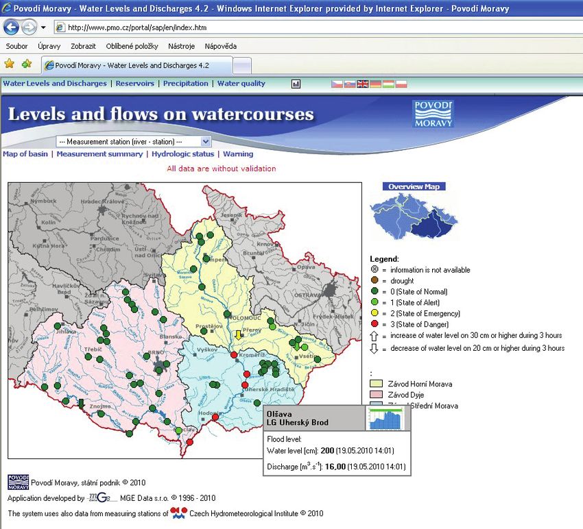
Report on Achievements in FP 9

4.2 Major developments in flood risk management

4.2.1 Germany – Bavaria & Baden-Wuerttemberg

Improvements in flood forecasting and warning
Both in Baden-Wuerttemberg ( www.hvz.baden-wuerttemberg.de/ ) and in Bavaria
(www.hnd.bayern.de/ ) flood early warning systems and flood forecast models are in use for all larger
river catchment areas.

Structural flood protection projects
In Baden-Wuerttemberg and in Bavaria number of projects focussed on building new flood protection
structures as well as on the improvement of existing flood protection facilities. Based on the Flood
protection action programme 2020 in Bavaria every year approximately 115 million € are invested in
flood protection (in the years 2006 - 2008 the annual budget stretched up to 150 million €).
Approximately 75% of that budget is invested in the Danube catchment area. As a consequence, in
the Danube catchment area in Bavaria, more than 200 000 additional inhabitants were protected
sufficiently against floods during 2001-2005. In 2007 the polder “Weidachwiesen” at the river Iller
was completed as the first controlled flood polder in Bavaria (retention volume approximately 6,3
millions m3). In addition, the reactivation of natural retention areas was forced. In the Bavarian part of
the Danube catchment area between 2001 and at the end of 2005 approximately 16 km of dykes were
set back and approximately 5 million m3 retention volume were re-activated.
Capacity building, preparedness & flood mitigation
Baden-Wuerttemberg: in conjunction with the development of the flood action plan for the Danube in
Baden-Wuerttemberg. Bavaria: relevant improvement after floods 2005. At the river Mangfall a new
hydraulic model for simulating the impacts of breeched levees during a flood event was established.
Progress in implementation of EFD
On the 1st of March 2010, the new Federal Water Management Act came into effect. On the same day,
the State of Bavaria enacted the Bavarian Water Act. Therefore all necessary legal steps for the
implementation of the EFD have been made.

ICPDR / International Commission for the Protection of the Danube River / www.icpdr.org
Report on Achievements in FP 10

By May, 26th 2010, the Competent Authorities and the Units of Management had to be reported to the
European Commission. Competent Authorities are the Ministry of the Environment, Nature
Conservation and Transport in Baden-Wurttemberg and the State Ministry for the Environment and
Public Health in Bavaria. Due to the commitment of the Danube Declaration (no. 32), adopted at the
IPCDR Ministerial Meeting 2010, the same sub-basins were reported as Units of Management to EC
which defined for the Flood Action Plans in the ICPDR Action Programme for Sustainable Flood
Protection. That means that the Upper Danube and the Inn sub-basins are regarded as separate Units of
Management.

The next step will be the preparation of Preliminary Flood Risk Assessment (PFRA) for the areas of
potential significant flood risk (APSFR). In Bavaria, this will be finished by the end of 2010, making
use of Art. 13 of the EFD. In Baden-Württemberg the same activity will be finished by the end of
2011. The applied method is based on an intersection of stream courses and spatial planning data.
Based on the results of the PFRA, flood hazard maps and flood risk maps will be designed up to
December 22nd 2013. These maps are the source for the Flood Risk Management Plans which have to
be established up to 2015. All steps have to be coordinated between the neighbours in a sub-basin. For
this reason, Baden-Wurttemberg and Bavaria are in close contact to ensure a common process.

4.2.2 Austria

Improvements in flood forecasting and warning
Austria has a federal structure with nine provincial states. According to this structure the responsibility
for the flood forecasting was assigned to the local Hydrological Services.
The Hydrological Service in Austria operates a modern hydrometrical network for the quantification
of the water cycle in Austria. The network for monitoring water quantity consists of about 600
discharge measuring points, 1000 precipitation measuring points (air temperature) and 3000
groundwater measuring points. All data on the water cycle in Austria are collected, prepared and
disseminated by this organisation.

    no flood- forcast available
    be planned
    in test operation
    in operation

                                                                                             Overview of flood –
forecasting measures in Austria

The 2002 and 2005 flood events triggered activities regarding flood forecast and started any new
activities related to flood forecasting in Austria. A new generation of flood - forecast models

ICPDR / International Commission for the Protection of the Danube River / www.icpdr.org
Report on Achievements in FP 11 (conceptual water-balance rainfall-runoff models combined with flood routing models) was developed after this flooding. The discharge forecast results for the river Danube in Austria are published on the internet. The precipitation forecasts come exclusively from the Meteorological Service in Austria – ZAMG (http://www.zamg.ac.at). Discharge forecasting gauges on the river Danube in Lower Austria (http://www.noel.gv.at) Links for further information: 1. http://www.noel.gv.at/Externeseiten/wasserstand/htm/wndcms.htm (discharge-forecast information for the Danube and for other gauges in the Danube river basin in Lower Austria) 2. http://gis.lebensministerium.at/ehyd (historical hydrographical data, available for download) 3. http://pegel-aktuell.lfrz.at/ (Overview about the online discharge and water level gauges in Austria) Structural flood protection projects In Austria the “Flood programme 2016” was adopted. Main goals are to improve the existing or to build new flood protection measures (structural as well as non-structural) and to accelerate the making of hazards maps. Based on the programme Austria invests approximately about 400 million € per year in flood protection measures (financed by the Federal State, the Provinces and the communities with an average percentage of 50 : 35 : 15). There is a clear hierarchy in the implementation of flood protection measures (laid down in the Austrian water act and the hydraulic engineering assistance act) as followed: o Non-structural measures have priority over structural measures o Measures in the catchment area have priority over measures at the main channel o Retention measures have priority over linear structural measures o (Near) natural methods of building have priority over methods that are less so o Area used for agriculture and forestry are not be specifically protected ICPDR / International Commission for the Protection of the Danube River / www.icpdr.org
Report on Achievements in FP 12

o     Avoidance of those measures that would increase erosion and the discharge of drain water

Capacity building, preparedness & flood mitigation
To increase preparedness and awareness the Ministry published a series of brochures (e.g. for house
owners) and updated the public appearance on the internet constantly.
An Austria-wide internet platform for natural hazards with the focus on floods has been developed,
(www.hochwasserrisiko.at), in which all inundation areas (flood affected areas) and the hazard maps
(if available) are shown.

Progress in implementation of EFD
The first intended step for the implementation of the Flood Directive, the Preliminary Floodrisk
Assessment (PFRA), will be finalized in mid 2011 and presented to the public probably in October
2011. A technical guideline from the Federal Ministry of Agriculture, Forestry, Environment and
Water Management (BMLFUW), coordinated with the Provinces about the technical requirements and
contents of the following flood hazard and flood risk maps is finalized.

4.2.3 Czech Republic

Improvements in flood forecasting and warning
In the Czech part of the Morava river basin the Czech Hydrometeorological Institute (CHMI) is
responsible for the both meteorological and hydrological forecasting and warning. In the Czech
Republic, Central Forecasting Office (CFO) and six Regional Forecasting Offices (RFO) have
meteorological and hydrological departments cooperating closely together. Forecasting methodology

ICPDR / International Commission for the Protection of the Danube River / www.icpdr.org
Report on Achievements in FP 13

has been improved by introducing hydrological models into the forecasting service mainly after the
extreme flood in 1997.
The hydrological forecasting system is connected to the meteorological forecasting system. The flood
forecasting system regularly provides hydrological forecast to the River Basin Authorities and other
stakeholders and public them on the CHMI web site. In case of flood it informs the flood protection
authorities and other participants involved in the flood protection about actual flood danger and flood
development. Warning messages are disseminated if extreme meteorological or hydrological
conditions are being forecasted and during floods are accompanied by information on the flood
evolution and its further prediction.
The forecasting system HYDROG has been set up for the whole Morava river basin containing 25
forecasting profiles. The lead time of the forecast is 24 and 48 hours. It includes also reservoir
operation routines for optimalization of the possible future operations. The model is running every
day. There is a close cooperation with Austria in place: in the regional Brno office of the Czech
Hydrometerological Institute every day a discharge forecast for the Austrian gauge stations Raabs and
Schwarzenau in the Dyje river basin is computed. In return Austria provides extended meteorological
data for Austrian part of the Dyje/Thaya river basin.
Continuous data on water courses and reservoirs are available at following web services partly
provided in English and other languages:
                       http://www.pmo.cz/portal/sap/en/index.htm
               (partly provided in English, Slovak, German, Hungarian, Polish language)

ICPDR / International Commission for the Protection of the Danube River / www.icpdr.org
Report on Achievements in FP 14
Within the frame of the European Territorial Co-operation 2007 – 2013 (AT, CZ) a project on Flood
forecasting in the confluence area of the rivers Morava and Dyje has been launched. As a result of this
project the extended upgrade of the forecasting model HYDROG for the Morava river basin has been
prepared. Since February 2010 the upgraded model is in test operation and the forecasts for the profile
Hohenau (A) and Moravský Sv. Ján (SK) on the Morava River have been disseminated daily. Work on
this project will continue also in 2011.
Following improvements of flood forecasting and early warning system have been recorded:
- interlinking regional and national agencies to facilitate and promote the exchange of source data;
- routing of the information downstream as the basis of improving efficiency and lead time of flood
forecasting and warning ;
- improving the methodology and tools for data collection, processing, forecasting and
dissemination - nowcasting and flash flood forecasting is in place;
- end-users training accomplished and feedback collected.
Thanks to the European Structural and Cohesion funds the Ministry of the Environment provides
subsidies for elimination of the flood risk thorough the Operational Programme Environment
(www.opzp.cz). One of the objectives is support of building local flood alert systems for
municipalities and regional authorities. In line with this simple local systems are built in Morava river
basin having a simple design for obtaining the data from ultrasonic water stage indicators and
pluviometers connected with modern wireless public address system and with regional web pages.
Structural flood protection projects:
The new flood protection measures have been prepared since the extreme flood in 1997. They include
the construction of new retention storages as dry polders with the aim to reduce and delay the flood
wave, to further protect the local settlement areas and to revitalize the floodplains. Preventive
measures focus primarily on technical proposals where their realization provides tangible benefits as
ICPDR / International Commission for the Protection of the Danube River / www.icpdr.orgReport on Achievements in FP 15
well as the opportunities for the land-use changes. In 1999 – 2001, 14 flood protection measures were
built with total costs of about 177 mill. of CZK.
In the years 2002 – 2007 the Ministry of Agriculture started the programme “Flood Prevention” and
during this programme about 75 structural flood protection measures were built in the Morava river
basin by all river administrators (Morava River Board, s.e., Agricultural Water Management Authority
and the Forests of the Czech Republic, s.e.). The total costs for these measures were about 1518 mill.
of CZK.
The preparation of flood protection measures continues in the Czech Republic with the programme
“Flood prevention II” in the years 2008 – 2013, where about 10 bill. of CZK is allocated for the flood
prevention measures.
The flood protection measures finished till the end of 2009 in the Morava river basin:
Period Programme No. of flood protection Total costs
measures (mill. of CZK)
1999 - 2001 - 14 177
2002 - 2007 Flood Prevention 75 1 518
2008 - 20013 Flood Prevention II 47 487
Thanks to the Structural and Cohesion funds of EU the Ministry of the Environment provides
subsidies for elimination of the flood risk through the Operational Programme Environment
(www.opzp.cz) allocating about 100 mil. EUR for projects in 2007-2013.
Capacity building, preparedness & flood mitigation
Water Management Information Portal “Water” was established by the Ministry of the Agriculture and
Ministry of the Environment where the latest information about water in the Czech Republic,
including floods, is available to the public.
ICPDR / International Commission for the Protection of the Danube River / www.icpdr.orgReport on Achievements in FP 16
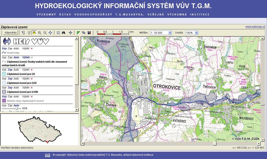
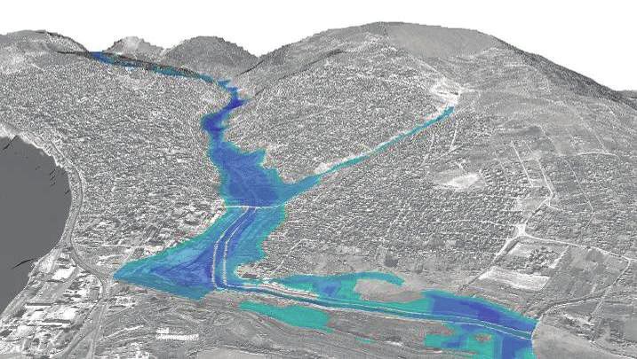
Information about available flood zones is also available to the public through the web service HEIS
VÚV and by POVIS – Flood information service:
Examples of the flood zones at Morava and Drevnice rivers junction:
Ministry of the Environment organizes training for the members of the flood committees and state
administrations in the Morava river basin. Flood information system POVIS together with Digital
flood management plan of the Czech Republic was established by Ministry of the Environment. This
information platform has been developing since 2006 and provides now important information to
flood committees and to public, runs shared databases of contacts, digital flood management plans,
hydrological characteristics, flood plains, objects in flood risk and object of flood risk and so on.
Development of information system is funded by the Operational Programme Environment as well as
by local alert systems. About hundred of municipal or regional projects have been launched since
2008. The adopted projects will primarily address the vulnerability of small catchments and local
floods.
River Basin Authorities together with the Czech Hydrometeorological Institute re-established the
“dispatcher games”, where teams from dispatching centres for dam and hydraulic structure
manipulation come together to compete with flood simulations in the real catchment.
New transnational initiative to tackle flooding in transboundary area shared by Czech Republic,
Austria, Hungary and Slovakia is project CEframe - Central European Flood Risk Assessment and
Management, supported from the European programme Central Europe 2013. The scope of the project
is:
• Sustainable integrated flood risk management
• Joint Assessment of Flood Management
• Harmonization of methodologies for flood protection, keeping compliance to EU Flood
Directive
Ceframe results will increase protection capacities of areas particularly affected by danger of flooding.
In these areas flood damages have had significant negative impacts on settlement and economy. The
reduction of risk will lead to higher safety for people living there and to investments in new
enterprises. CEframe will strongly consider the common interests and goals of project partners
ICPDR / International Commission for the Protection of the Danube River / www.icpdr.orgReport on Achievements in FP 17 following their national regulations in the respective countries and their will to seek a balanced and constructive approach to existing problems. Starting with setup of the basic data bases, the current state of flood protection and flood risk will be assessed. A comprehensive inventory of all currently applied strategies completes the basic analysis, with objective of building the ground for future-oriented activities and for gathering best practices out of the partner pool. Further influencing factors - land use activities - are identified. Interactions between land uses and flooding are assessed. The driving forces and different influences will be merged, and their impacts on danger of flooding will be analyzed. The concluding step is development of appropriate measures and exclusion of their possible negative effects, together with a web-based information and communication site, to reach a sustainable flood protection management. All measures concerning flood prevention and protection will be compiled in an action plan. The contributions of the partners, cooperating in the activities by using jointly developed methodologies, will be processed in form of reports, maps, guidelines, common tools and management proposals. One of the project aim is also harmonization flood risk management in frame of the Directive 2007/60/ES. Progress in implementation of EFD Transposition and implementation of floods directive is under the competences of Ministry of the Environment and Ministry of Agriculture. Transposition into Water Act and related legislation is supposed to be finished in 2010. The Act No. 150/2010 Coll. updates the Czech Water Act according to the requirements of European Flood Directive since August 2010. The EFD implementation is coordinated by the national expert group “Implementation of EFD”. In 2009 the suitable methodology for preparation of flood hazard maps and flood risks maps was developed based on available data sources in the Czech Republic. The preparation of the preliminary flood risk assessment is underway and it is expected to be finished in 2010. A methodology for identification of the areas with potential significant flood risk, which covers risk of fluvial floods, has been finished this year. First outcomes of identification of the areas with potential significant flood risk in 2009 are shown in the figure below (river stretches in red color are those identified as having significant risk from fluvial floods). Work is still ongoing on methodology covering flash and pluvial floods. The projects of flood mapping were launched in 2009 with co-financing from the Operational Programme Environment and are expected to be finished by the deadline given by EFD. Flood hazard and flood risk maps will be prepared for about 2500 kilometers of river stretches. ICPDR / International Commission for the Protection of the Danube River / www.icpdr.org
Report on Achievements in FP 18

In the Czech Republic the flood protection is also an integral part of the first River Basin Management
Plan. The Morava and Dyje river basin management plans were finished in 2009 and the plans were
adopted by the regional authorities. The WFD programme of measures includes flood protection
measures as well. Ministry of the Environment allocated 2 bil. CZK in the Operational Programme
Environment to support realization of some structural measures planned in RBMPs.

4.2.4 Slovakia

Improvements in flood forecasting and warning
A key issue is the implementation of a national project POVAPSYS – Flood warning and forecasting
system of the Slovak Republic. The system consists of 12 main subsystems – Integrated system of
operation, Network of terrestrial meteorological stations, Network of terrestrial hydrological stations,
Telecommunication technologies and telecommunication computer, Transmission and processing of
meteorological satellite data, Network of meteorological radio locators, Other appliances of remote
sensing, Information technologies, data processing and storage, Meteorological forecasting methods
and models, Hydrological forecasting methods and models, Information dissemination to users,.
Existing networks, instruments and appliances were in the frame of the project upgraded, modernized
and extended.
Trilateral cooperation (Czech Republic – Austria – Slovakia) which focuses on the improvement of
flood forecasting in the whole Morava river basin is under testing. On-line information on the actual
development of hydrological situation is available at
http://www.shmu.sk/sk/?page=1&id=hydro_vod_all#tab

Structural flood protection projects:
The relevant projects are listed in the following table:

ICPDR / International Commission for the Protection of the Danube River / www.icpdr.org
Report on Achievements in FP 19

reporting unit river basin river                   project                                         timeplan        funding                     description
Pannonian      Danube          Danube              Bratislava - Flood Protection                   2007 - 2010     85 % Cohesion Fund, 15 % Construction of a new and reconstruction of existing flood
Central Danube                                                                                                     national sources         protection lines and measures at 8 partial localities between
                                                                                                                                            Devin and Sap, pumping stations, mobile flood protection
                                                                                                                                            elements, flood protection walls and dykes, sealing of
                                                                                                                                            underground
                                                   Reconstruction of left-side flood protection 2003 - 2005        80 % Structural Funds, 20 % Sealing of flood protection dyke underground by means of
                                                   dyke of the Danube river and its underground                    national sources            cut-off walls
                                                   and the Kosihy pumping station
                                                   Reconstruction of flood protection line in      2007 - 2008     80 % Structural Funds, 20 % Construction of a new flood protection wall in combination
                                                   Sturovo                                                         national sources            with mobile elements, sealing of underground

Morava           Morava        Morava              Dykes and flood lines reconstruction, Morava 2007 - 2008        national sources            Raised crest of dykes at several sections, sealing of dykes
                                                   River rkm 89,5 – 97,05                                                                      underground by means of cut-off walls, construction of
                                                                                                                                               flood protection walls in selected sites
                                                   Suchohrad - Reconstruction of flood protection 2009 - 2010      80,75 % Cohesion Fund,
                                                   line                                                            19,25 % national sources

                               Malina              Malina River training, rkm 4,453 – 11,5 , and 2006 - 2008       national sources
                                                   its tributary Zohorsky creek

Vah – Hron -     Vah           several rivers      Floods at the territory of Slovakia in the period 2000 - 2005   national sources            Reconstruction of flood protection dykes in the section
Ipel                                               1997-1999, removal of consequences and                                                      Piestany-Horna Streda, river training works Suciansky
                                                   preventive measures                                                                         potok
                                                   Swiss Aid – DEZA Directorate for                2004 - 2005     majority from Swiss funds   Polders in Lehota pod Vtacnikom, Sučany – flood
                                                   Development and Cooperation, Ministry of                                                    protection,
                                                   Foreign Affairs
                               Vah                 Kralova hydraulic structure - removal of 1997 2005 - 2007       80 % Structural Funds, 20 % removal of 1997 flood consequences, protection dyke
                                                   flood consequences                                              national sources            stabilization
                                                   Kralova hydraulic structure - left-side flood   2001 - 2009     national sources
                                                   protection dyke stabilization
                               Rieka               Čadca – Rieka river regulation                  2007 - 2009     national sources
                               Nitra               Nové Zámky town – left-side flood protection 2005 - 2009        national sources
                                                   dyke increasing, rkm 6,466 – 7,795

   ICPDR / International Commission for the Protection of the Danube River / www.icpdr.org
Report on Achievements in FP 20
Komjatna Komjatna – Komjatna river training 2005 - 2009 national sources
Trnovka Žilina – Trnove - river training of Trnovka 2007 - 2009 national sources
water course
Maly Dunaj Trstice – Cierna voda, Maly Dunaj, flood 2006 - 2009 national sources
(Small Danube) protection I. phase, Cierna voda river right-
side flood protection dyke
Hron Podluzianka Floods at the territory of Slovakia in the period 2000 - 2005 national sources Flood protection lines reconstruction in Levice
1997-1999, removal of consequences and
preventive measures
several streams Swiss Aid – DEZA Directorate for 2004 - 2005 majority from Swiss funds Polders in Brezno, Lubietova
Development and Cooperation, Ministry of
Foreign Affairs
Kabatovsky creek Brezno – modification of outflow regime of 2008 - 2009 national sources
Kabátovský creek, rkm 1,182 – 1,583
Ipel Ipel, Stiavnica Floods at the territory of Slovakia in the period 2000 - 2005 national sources River training works at the rivers Ipel, Stiavnica,
1997-1999, removal of consequences and
preventive measures
Ipel Kalinovo – Ipel river training, rkm 174,854 – 2009 - 2010 80,75 % Cohesion Fund,
175,325 19,25 % national sources
Krupinica Krupina – Krupinica river training, rkm 43,009 2005 - 2007 80 % Structural Funds, 20 % River training works at partial sections
– 43,690 national sources
Tisa Bodrog several rivers Floods at the territory of Slovakia in the period 2000 - 2005 national sources 35 partial structures – 12 pumping stations, 7
1997-1999, removal of consequences and reconstructions of flood protection dykes, 2 canal training
preventive measures works, 12 river training works, reconstruction of hydraulic
structures at Laborec river in Petrovce
Kamenec, Swiss Aid – DEZA Directorate for 2004 - 2006 majority from Swiss funds Polders in Fricka – on Kamenec stream, in Vysny Tvarozec
Sverzovka Development and Cooperation, Ministry of on Sverzovka stream
Foreign Affairs
Sibska voda Bardejov - river training of Sibska voda 2005 - 2006 80 % Structural Funds, 20 % River training of Sibska voda channel, which endangered
national sources during floods town of Bardejov and its valuable cultural-
historical monuments
Stary jarok Bystre – reconstruction of Stary jarok stream, 2005 - 2006 80 % Structural Funds, 20 % Construction of a new flood channel
II. phase national sources
Laborec Koskovce - right-side flood protection dyke 2008 - 2009 national sources Reconstruction of flood protection dyke
ICPDR / International Commission for the Protection of the Danube River / www.icpdr.orgReport on Achievements in FP 21
reconstruction
Ondava Velka Domasa hydraulic structure 2007 - 2008 80 % Structural Funds, 20 % Raise of the level of dam sealing core
national sources
Hornad Nr. 309 stream Dacov – Nr. 309 stream training 2005 - 2007 national sources
Velky potok Sarisske Sokolovce – Velky potok stream 2008 - 2008 national sources
training
Niznoklatoviansk Nizny Klatov – Niznoklatoviansky stream 2005 - 2008 national sources
y training
potok
Slana Stankovicka Rudna – flood protection measures 2008 - 2008 national sources
Rimavica Kokava nad Rimavicou – river training of 2007 - 2008 80 % Structural Funds, 20 % River training works at partial sections
Rimavica river national sources
ICPDR / International Commission for the Protection of the Danube River / www.icpdr.orgReport on Achievements in FP 22
Capacity building, preparedness & flood protection
• Development of numerical models and GIS applications for the purposes of flood forecasting
and warning systems, operation of hydraulic structures, design of flood protection measures,
flood hazard and flood risk mapping, crisis management (long river sections and parts of river
basins);
• Improvement of public involvement in the processes of flood risk awareness and preparedness
raising;
• Coordination of spatial planning with flood management.
Progress in implementation of EFD
• The EU Directive on the assessment and management of flood risks was transposed into
legislation of the Slovak Republic (new Flood Protection Act Nr. 07/2010).
• The Slovak Water Management Enterprise, state owned enterprise has prepared project which
will ensure execution of all EFD goals on the territory of the Slovak Republic. It should be co-
financed by EU Cohesion Fund.
• The objectives of EFD were fulfilled (completely or partially) in following locations:
• Danube, Morava Rivers – produced flooding lines in Bratislava, its centre, parts and
suburbs Devin, Devinska Nova Ves, Petrzalka, Zitny ostrov.
• Within the framework of “Danube FLOODRISK” international project, managed by
Romania, will be produced the flood risk maps of Danube River (up to 2012),
• Pilot project on flood risk assessment in the Myjava river basin – project approved,
financing secured, project in implementation,
• Within the framework of “CEframe” international project will be produced the flood risk
maps of Morava and Myjava Rivers (up to 2013),
• Vah River (hydrodynamic modelling, flood maps) in section Trencin- Kralova (project in
implementation), sections of Kysuca and Domanizanka Rivers (hydrodynamic modelling,
flood maps),
• Hron River (hydrodynamic modelling, flood maps) in section Rudno nad Hronom-Velke
Kozmalovce and in town residential area of Banska Bystrica,
• Ipel River (hydrodynamic modelling, flood maps) in section Trenc-Sahy, Podlužianka
River in town residential area of Levice (project in implementation),
• The sections of Bodrog River, Latorica, Uh, Ondava and Laborec Rivers (hydrodynamic
models),
• The sections of Hornad River, Torysa, Svinka, Mala Svinka, Lutinka and Sekcov Rivers
(hydrodynamic modelling, flood maps) - project in implementation
4.2.5 Hungary
Improvements in flood forecasting and warning
Before 2004, using a € 2 million aid of the Hungarian government, an automated hydrometeorological
and hydrological monitoring system has been established in Transcarpathia, UA, including USW data
transmission system, extending to the whole territory of Transcarpathia, data procession centre in
Uzhgorod, 15 automated stations, microwave connection between Uzhgorod and Nyíregyháza, HU.
Maintenance of the system is undertaken by Hungary.
ICPDR / International Commission for the Protection of the Danube River / www.icpdr.orgReport on Achievements in FP 23
Extension and upgrade of the Hungarian automated monitoring network is continuously going on,
there are 15 regional hydrographical remote monitoring networks with more than 200 stations in
operation. These stations regularly measure 15 parameters including those of water quality. A new
Doppler S-band radar station near Nyíregyháza has been put into operation, aim of which is detecting
the Upper-Tisza catchment.
A new WEB site (http://www.hydroinfo.hu/) has been launched to replace the former HYDROINFO.
It is in Hungarian at this moment but the translation is in progress. Water level time series of the last
30 days can be seen from the Danube and Tisza valley upstream of their confluence
(http://www.hydroinfo.hu/Html/hidinfo/hidinfo_map.html#). Hydrological forecasts are available at
http://www.hydroinfo.hu/Html/hidelo/hidelo_graf_duna.html for the Hungarian Danube and at
http://www.hydroinfo.hu/Html/hidelo/hidelo_graf_tisza.html for the Hungarian Tisza stretches.
Further information on gauges and water levels of Hungary and the Danube Basin can be found at
http://www.ovisz.hu/index.php?module=map.
Structural flood protection projects:
Reinforcement of existing flood embankments: 94.8 km (91.6 km in the Tisza Valley and 3.2 km
along the Danube and tributaries);
New flood embankments: 8.2 km (3.4 km in the Tisza Valley and 4.8 km along the Danube and
tributaries);
Repair and reconstruction of flood defences damaged during the extreme floods: 44.9 km (all in the
Tisza Valley);
In the frame of the ‘Upgrade of the Vásárhelyi Plan’ (Tisza) project (information in Hungarian at
http://www.vizugy.hu/vtt/index.html# ):
• improvement of the flood conveyance capacity in the vicinity of the Tivadar bridge on the
Upper-Tisza. Along the Middle-Tisza between Kisköre and Szolnok similar project will start
in the next year, with the help of the EU Structural Funds;
• construction of two flood retention basins (Cigánd-Tiszakarádi and Tiszaroffi) with a total
volume of 191millions m3 has been finished by the end of 2008 and 2009;
• experimental operation of the Tiszaroff flood retention reservoir has proved the efficiency of
it, during the 2010 spring flood.
• construction of flood gate at the mouth of the Lónyay principal canal was finished in 2007
(substituting the reinforcement of the dikes of the Lónyay principal in a total length of 100
km);
• dike relocation and 600 ha floodplain restoration at the Bivalytó bottleneck upstream the
Vezseny bend ; (finished in 2008, but the final removal of the old dike happened only during
the 2010 spring flood);
• The construction of two new flood retention basins has started in 2009. The Hany-Tiszasüly
(247 million m3) and the Nagykunsági (99 million m3). The deadline for them is in the first
half of 2012.
Capacity building, preparedness & flood mitigation
Continuous development of the Lotus Notes based flood emergency information system, digitisation
and upgrade of the contingency and confinement plans.
Progress in implementation of EFD
At present the maps showing flood extent of 1% and 0,1% probability flood are available. This will be
one of the bases for the preliminary flood risk assessment. The methodological project was finished in
ICPDR / International Commission for the Protection of the Danube River / www.icpdr.orgReport on Achievements in FP 24
2010. National guideline on this issue has been prepared and is subject to upgrading. GIS based digital
flood hazard maps are being developed for several smaller flood areas, covering approx. 5% of the
total floodplains. A budget for the implementation of the EU Flood Directive has been allocated for
2007-2013 in the Energy and Environment Operative Programme of the National Development Plan.
The data collection for the flood risk and flood hazard maps will start this year.
4.2.6 Slovenia
Improvements in flood forecasting and warning
The Environmental Agency of the Republic of Slovenia, Hydrology Forecasting Department is
responsible for forecasting hydrological events on the national level and launching flood warnings to
the Notification Centre of the Republic of Slovenia. The Agency's mission is to monitor, analyse and
forecast natural phenomena and processes in the environment, and to reduce natural threats to people
and property.
Since 2005 the operative practises in national forecasting department improved with forecasting tools
based on international cooperation. In the time period from 2005 to 2007 The National hydrological
forecasting service has become a full member of EFAS (European Flood Alert System) and MAP D-
Phase (Mesocsale Alpine Program), covering forecasts up to 10 days ahead. Within bilateral
cooperation between Land Steiermark (Austria) and Slovenia in 2006 a common operative Flood
Forecasting System for the river Mura was established.
In 2009 the most extensive project titled "Upgrading the system for monitoring and analysing the state
of the water environment in Slovenia" has launched. The project is financed by the EU Cohesion Fund
and the share of Slovenia’s co-funding. The purpose of the project is to increase the capacity of the
Environmental Agency of the Republic of Slovenia to monitor, examine and forecast water cycle
factors. The particular important is balanced spatial planning and thus improved water management
and the setting up of representative grids of measuring points for evaluating the state of water bodies.
The protection of human health and life against the consequences of natural disasters (protection
against floods and droughts) is another very important aspect, which should be based on correct and
timely meteorological and hydrological forecasts and the provision of data in real time.
The expected results of the project by 2015:
• 248 upgraded and new measuring points throughout Slovenia;
• replacement of equipment at 33 measuring points;
• installation of an additional weather radar;
• new equipment for periodic hydrological measurements and sea dynamics measurements;
• provision of conditions for the operation of the Maritime Meteorological and Oceanographic
Service;
• upgrading the computer infrastructure in the Computer Centre;
• upgrading and enlarging chemical, analytical, biological and calibration laboratories;
• setting up systems to forecast the hydrological state of the Sava and the Soča rivers, sea
dynamics, state of the underground water in alluvial aquifers and drought monitoring.
Structural flood protection projects:
Repair and reconstruction of water infrastructure, damaged during the extreme (flash) floods 2007, is
continued.
ICPDR / International Commission for the Protection of the Danube River / www.icpdr.orgReport on Achievements in FP 25
Spatial planning of flood protection measures in two significant flood risk areas are finishing in
2010/2011 and construction starting are planed for 2012/2013. Spatial planning of flood protection
measures for at least two significant flood risk areas planed to be started at 2011.
Ongoing project of construction of hydropower stations on lower section of river Sava involved
maintenance, restoration, improvement and the construction of new structural flood defences (dikes,
detention reservoirs) for flood protection of existing settlements.
Capacity building, preparedness & flood mitigation
New legislation was adopted, which defined the national methodology for flood hazard and flood risk
mapping, and also the legislation which sets the preventive rules for urban planning and construction
of buildings in flood hazard areas. The preparation of hazard maps started on local scale and the local
administration, investors and general public in local communities are participating in process of spatial
planning with grater awareness of flood danger.
Progress in implementation of EFD
In connection to Flood Directive Slovenia started an important changes in flood risk prevention
practices. New legislation was adopted, which defined the national methodology for flood hazard and
flood risk mapping, and also the legislation which sets the preventive rules for urban planning and
construction of buildings in flood hazard areas. Transposition of EFD to Slovenian legal system was
concluded on time and National Work Programme for preparation of flood risk management plans was
signed in May 2009. A first hazard indication map (HIM) was published in 2007 and is now under
review. This map will also be a basis for Preliminary Flood Risk Assessment, finalization of which is
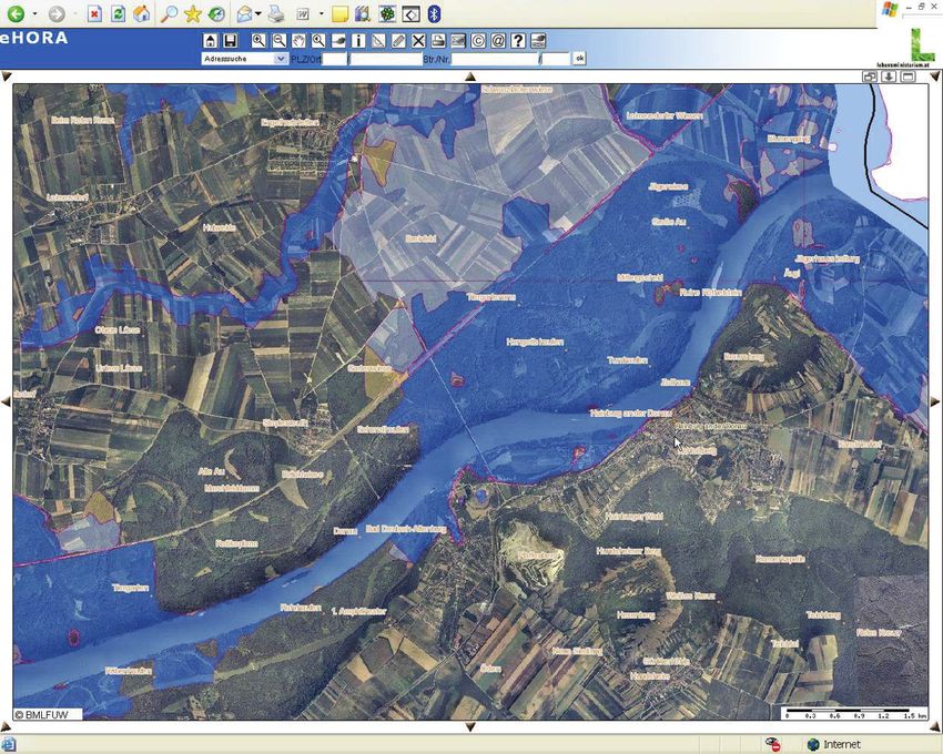
planed for 2010/11. The indicative flood map, which is a subject of updating, is public available:
http://gis.arso.gov.si/atlasokolja/profile.aspx?id=Atlas_Okolja_AXL@Arso .
Based on the new legislation new principles were introduced in flood risk reduction planning:
• precautionary principle (information on flood hazard, awareness of direct and indirect flood
risks);
ICPDR / International Commission for the Protection of the Danube River / www.icpdr.orgReport on Achievements in FP 26
• high priority on non-structural measures (protection of non urbanized flood plains, limitations
for urban planning in flood areas, intervention and preparedness planning, early warning
systems, building standards for flood areas);
• structural measures: measures for flood management in the catchment (retention) should have
priority over structural changes of main river morphology and should take into account other
objectives (water ecology, biodiversity);
• planning priorities for risk reduction measures are focused on existing risks to human health,
important economic activities, environment and cultural heritage;
• level of protection should be based on cost-benefit analysis.
4.2.7 Croatia
Improvements in flood forecasting and warning
Currently, a national-wide hydrological monitoring network consolidation project is under way,
aiming at further standardization, improvement and optimisation of data collection and dissemination.
At present, 142 hydrological stations are available on line. Number of automatic hydrologic stations is
shown in the following table:
NUMBER OF AUTOMATIC HYDROLOGICAL STATIONS
DANUBE SUB BASINS 142
SAVA RIVER BASIN 116
DANUBE AND DRAVA RIVER BASINS 26
Basic information on water levels and flood warnings is available for public on a redesigned webpage
of Hrvatske vode (http://isite.voda.int/Default.aspx?sec=191 ), webpage of State Hydrometeorological
Service (http://hidro.hr/hidro.php?id=hidro¶m=Podaci ), on WAP mobile phones and on teletext
of Croatian Radio Television.
For an internal use by Hrvatske vode a more comprehensive hydrologic data collection and
dissemination system is being built taking in consideration not only flood monitoring and warnings
but other requirements of water management as well.
Hydrologic data collection and dissemination system of Hrvatske vode
In cooperation with State Hydrometeorological Service, online meteorological data as well as weather
forecasts (Aladin and ECMWF models) are integrated in it.
ICPDR / International Commission for the Protection of the Danube River / www.icpdr.orgYou can also read