Hydromorphological evaluation of the river training impact on a multi thread river system (Belá River, Carpathians, Slovakia)
←
→
Page content transcription
If your browser does not render page correctly, please read the page content below
www.nature.com/scientificreports
OPEN Hydromorphological evaluation
of the river training impact
on a multi‑thread river system
(Belá River, Carpathians, Slovakia)
Anna Kidová1*, Artur Radecki‑Pawlik2, Miloš Rusnák1 & Karol Plesiński3
The paper evaluates the impact of river training works designed to address problems associated with
flooding on the braided-wandering Belá River in Slovakian Carpathians. This impact was investigated
after the flood event in July 2018 on 11 river reaches where the river engineering and management
intervention was applied. We analyzed its impact by spatio-temporal variations in river morphology
(12 channel parameters) and changes in cross-section and hydraulic parameters (flow velocity,
shear stress, stream power, W/D ratio) between pre- and post-flood management periods. The
research hypotheses related to decreasing geodiversity in managed river reaches, a rapid increase
in flow velocity during an extreme flood in river reaches where there is no sufficient floodplain
inundation due to artificially high banks built by river training works, and increasing erosive force
in the channel zone thanks to river management intervention were confirmed. The intervention in
the braidplain area of the Belá River resulted in an undesirable simplification of the river pattern,
loss of geomorphic diversity, loss of channel–floodplain connectivity, and disturbance and restraint
of hydromorphological continuity. Identification of main conflicts of the Belá River management
is important for clarifying the different approaches of stakeholders in the study area and aims to
provide an objective illustration of their consequences. The presented analyses could help in future
management issues as well as in the more critical decision-making process in vulnerable and rare
braided river systems on the present when we are losing so many natural rivers by human decisions.
The multi-thread pattern of a high-energy river1 reflects a natural bedload pulse system2 where the continual
transportation and aggradation of sediment material3 maintain a high level of geomorphic diversity. Temporal
variability in transport rates and channel morphology is a fundamental element of a braided river mechanism.
Multi-thread river systems with an intensive flow regime are prone to reoccupation of abandoned channels and
relocation of bars in the river’s active z one4. Avulsion due to channel shift to the lower part of the floodplain
is considered a sign of lateral channel instability5 exceeding the equilibrium thresholds. Non-cohesive gravel
deposits in wide braidplains with frequent and extreme variations in channel depth create during flood events
the proper conditions for sediment wave formation6. This typical longitudinal sediment connectivity considered
as a sediment pulse (e.g.7,8) provides natural settings in river system behavior and adjustment. Due to anthro-
pogenically influenced disruption of the natural development of river channels, there is a certain characteristic
sequence of morphological changes of the riverbed in the process of adaptation to changed conditions as a critical
barriers for landform modification9. The history of disturbance events determines the length of the evolutionary
record that must be evaluated to assess the timing, rates and extent of geomorphic adjustments to disturbances,
and whether these are expected, accelerated, suppressed or a nomalous10. The state of former river systems in the
European region over the past century reflects mainly progressive human impact (gravel mining, river training,
small hydropower plant construction, reforestation, etc.) contributing to significant morphological changes
mostly represented by channel incision and narrowing (e.g.11–16). In terms of hydromorphological assessment,
the Water Framework Directive (WFD) proclaims indicators and criteria for the significance of their i mpact17,
which interpret the disruption of a river system’s lateral and longitudinal continuity. Additionally, according to
the WFD, river management requires maintenance or improvement of the ecological state of rivers. It is worth
1
Institute of Geography, Slovak Academy of Sciences, Štefánikova 49, 81473 Bratislava, Slovakia. 2Faculty of
Civil Engineering, Cracow University of Technology, ul. Warszawska 24, 31155 Krakow, Poland. 3Faculty of
Environmental Engineering and Land Surveying, University of Agriculture in Krakow, al. Mickiewicza 24/28,
30059 Krakow, Poland. *email: geogkido@savba.sk
Scientific Reports | (2021) 11:6289 | https://doi.org/10.1038/s41598-021-85805-2 1
Vol.:(0123456789)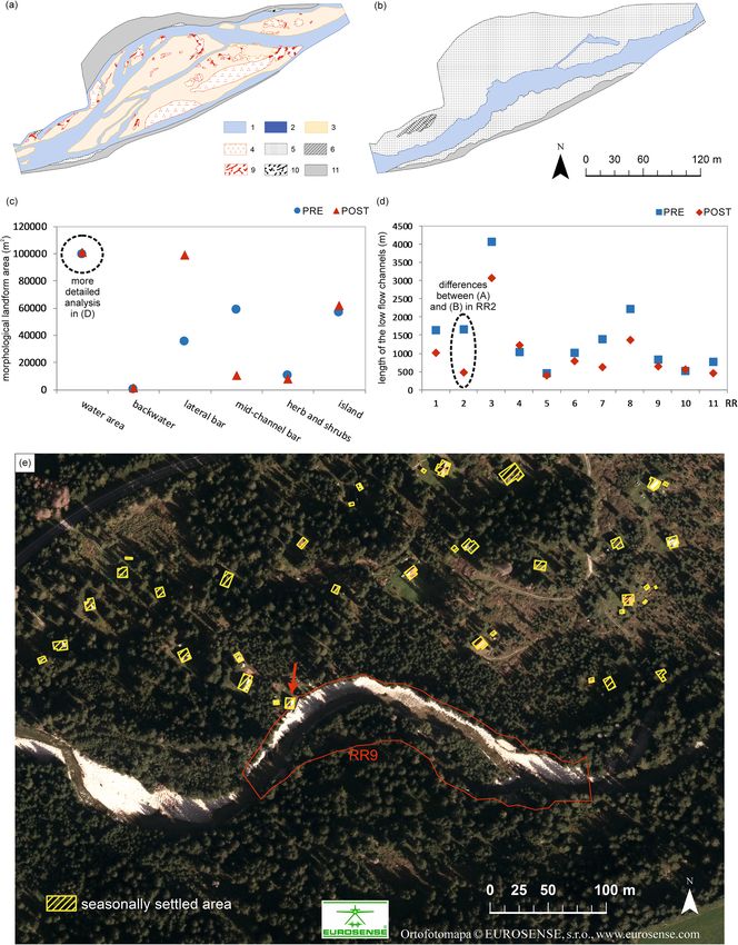
www.nature.com/scientificreports/
emphasising, though, that an improvement of the available EU guidances should be more focused on the causal
interrelationships between hydromorphological alterations, sediment transport and the biological (ecological)
status of freshwater e cosystems18. Moreover, Directive 2007/60/EC on the assessment and management of flood
risks (entered into force on 26 November 2007) shall be carried out in coordination with the WFD. The fact that
using the high-resolution multispectral images and topographic data at the national scale across Europe already
reached a good level of detail, sufficient to support hydromorphological assessment for W FD19 corresponds to
the methodological basis of our investigation on the Belá River. With a view to giving rivers more space in sense
of the nature-based solution concept20, municipalities involved as decision makers should consider, where pos-
sible, the maintenance and/or restoration of floodplains recommended by Solín21 within decentralization and
diversification of flood risk governance in Slovakia. Furthermore, in respect of adopting a holistic approach to
promoting the sustainable development of aquatic ecosystem m anagement22, a new assessment framework in
a river basin context (RBWSI—River Basin Water Sustainability Index) has been d eveloped23. Consequently,
equivalent process‐based approaches to river management have been applied elsewhere in the world (e.g. 24,25)
which gives us at least a high presumption of success in implementing similar approaches in our country as well.
The work presented here is analyzing the example of environmental change of multi-thread river channel
with external disturbances represent by river training as a main factor influenced its morphological response.
The present study was conducted in the Liptov Basin, located in the north of Slovakia, which contains the longest
multi-thread river in Slovakia. This paper evaluates how the engineering approach to river training has influenced
development of the hydromorphological complexity of the Belá River after the flood event in July 2018. On 11
river reaches (RR) where the management intervention was applied, we focused on the following quantitative
indicators: (1) changes in the planned and realized length of intervention; (2) spatial and temporal variation
in channel morphology; (3) changes in cross-section measurements; (4) changes in hydraulic parameters. The
research hypotheses are related to decreasing geodiversity in managed river reaches, a rapid increase in flow
velocity during an extreme flood, and increasing erosive force in the channel zone. Identification of main conflicts
of the Belá River management is important for clarifying the different approaches of stakeholders in the study
area and aims to provide an objective illustration of their consequences.
Study area
The Belá River represents a unique morphological and ecological river body located in the foreground of a
glacially modelled river basin in central European conditions in Slovakia (Fig. 1A). Thanks to its multi-thread
planform, it represents a typical gravel-bed braided and wandering r iver26 with a length of 14.92 k m27. A natural
process by the rapidly changing flow regime increases the transport of large amounts of sediment and frequent
relocation or creation of new gravel bars and arms (avulsions) on the adjacent fl oodplain14,15,27,28. During high
flood discharges, there is an important geomorphological effect of the connectivity of the Belá River braidplain
with the floodplain and the riparian zone. This type of hydrological connectivity of the entire river system is
particularly important from a geomorphological point of view for maintaining the natural erosion–accumulation
processes typical for high-energy rivers, to which the Belá clearly belongs29. In addition, a laterally connected
braidplain with riparian forest on the floodplain can fulfil a natural flood protection function during floods (i.e.
flood wave mitigation). Of course, the supply of sediments, nutrients and organisms also plays a major role.
From an ecological point of view, the Belá River creates specific habitats bound to the often-disturbed habitats
of gravel bars in the river’s active zone (e.g. habitat of Myricaria germanica), riparian flora or aquatic fauna (e.g.
Natura 2000 species). The Belá River together with its riparian zone creates a biocorridor (§2, letter e), Act no.
543/2002 Coll. about nature and landscape protection, National council of the Slovak Republic) of supra-regional
importance and, thanks to habitats of European importance (SKUEV0141), an area of 315.655 ha is included
in the Natura 2000 Network30 (Fig. 1B). Despite some human activity affecting, the Natura 2000 protected area
(flood protection dikes, bank stabilization near road, small hydropower plant operation), the Belá has retained
a near-natural multi-thread character along with some river s egments15. The Belá River basin has been included
by the Slovak Hydrometeorological Institute (SHMI) in the international category as a representative river basin
and is registered within the UNESCO International Hydrological Program31,32. The 16 km of the Belá WILDRiver
was the subject of a European Wilderness Society Quick-Audit in summer 2017 and met the Bronze Wilderness
Quality Standard (https://wilderness-society.org, European Wilderness Network). Additionally, the Belá River
from the confluence with the Váh River to the confluence of Kôprovský and Tichý creeks is part of all three zones
(A, B, C) of the Tatry biospheric reservation (BR). Most river management activities are in line with the official
Slovak Water Management Enterprise (SWME) policy focus mainly on flood protection issues.
The cool and humid air mass flowing into the Carpathian region from north to northeast caused intensive
atmospheric precipitation during 17–22 July 2018. The maximum daily precipitation and maximum discharge
at Podbanské gauging station were 35.8 mm and 85.9 m3 s−1 respectively, which caused a flood situation with
a 5-year recurrence interval (RI). At Liptovský Hrádok gauging station, the maximal discharge of 124.5 m 3 s−1
reflected a 5–10-year flood. This flood event reached the third degree of flood activity at both gauging stations33
and was announced as a flood risk by water authorities. The flood event on the Belá River resulted in bank
overflow at several sites, crossing the floodplain and road in one case, and intensive lateral bank erosion near
the holiday cottage area with one cottage at real risk (Fig. 3E). Technical realization of the river training per-
formed by the SWME within the braidplain of the Belá River according to the official technical documentation
consisted of the following steps: (1) release of obstructed cross-sections; (2) relocation of sediment material
(alluvial gravel bars) with a total volume of 46,600 m3; (3) removal of large woody debris (LWD) including its
root system; (4) repair of damaged flood protection dikes and stony grade-control structures by refilling a total
volume of 2050 m3 with quarry stones over 500 kg; (5) relocation of a total volume of 24,000 m3 of sediment
material within the riverbed; (6) changing the streamline of the main channel. All of these activities, specified
Scientific Reports | (2021) 11:6289 | https://doi.org/10.1038/s41598-021-85805-2 2
Vol:.(1234567890)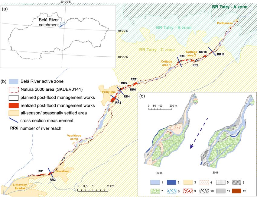
www.nature.com/scientificreports/

                                  Figure 1.  (a) Study area location in the north of Slovakia. (b) Spatial distribution of modified river reaches
                                  (sediment material transfer and extraction, transfer of heavy equipment) and repeated cross-section
                                  measurements in the Natura 2000 area of the Belá River (SKUEV0141). (c) Vectorized morphological channel
                                  parameters for the example of RR3 pre- (2015) and post-flood management intervention (2018), where 1—low
                                  flow channel area; 2—backwater; 3—bare mid-channel bar area (without vegetation); 4—mid-channel bar area
                                  with herb and shrub vegetation cover; 5—bare lateral bar area (without vegetation); 6—lateral bar area with
                                  herb vegetation cover; 7—island area with tree vegetation cover; 8—large woody debris (LWD) area in low
                                  flow channel; 9—LWD area on the mid-channel bar; 10—LWD area on the lateral bar; 11—floodplain area;
                                  12—artificial structure area. Dashed arrow represents flow direction. This figure was generated in ArcMap 10.3
                                  software.

                                  as necessary interventions to ensure the functioning of the riverbed, aimed to implement legislative measures
                                  to prevent further post-flood loss.

                                  Methods
                                  Analysis of the impact of river training on river morphology. Based on very accurate remote sens-
                                  ing data (provided by Eurosense, s r.o.) with a resolution of 20 cm pixel size, from reference conditions in 2015 in
                                  the pre-flood management period (imagery date: July 7, 2015) and conditions in 2018 in the post-flood manage-
                                  ment period (imagery date: August 12, 2018) and field reconnaissance, the planned and realized river training
                                  were quantified. Morphological changes to the river’s active zone were quantified and evaluated. Nine catego-
                                  ries of morphological parameters present in-channel landforms with different types of vegetation cover were
                                  studied: (1) water area, length of low flow channels; (2) isolated water area (backwater); (3) lateral gravel bar
                                  area without vegetation; (4) mid-channel gravel bar area without vegetation; (5) bar area with vegetation cover
                                  (herbs and shrubs); (6) island area (tree vegetation); (7) large woody debris area in low flow channels; (8) LWD
                                  area in the mid-channel bar; (9) LWD area in the lateral bar (Fig. 1C). The nine morphological parameters were
                                  chosen according to the possibility of their detection on the ortophotos and according to their relevance for the
                                  morphological in-channel landforms changes comparison as well as identification of the river pattern changes.
                                  Artificial channels formed in the river’s active zone by the accumulation or relocation of gravel in the form of
                                  broad and elevated lateral bars at least to the level of the floodplain or even above it were designated as artificial

Scientific Reports |   (2021) 11:6289 |                https://doi.org/10.1038/s41598-021-85805-2                                                     3

                                                                                                                                                 Vol.:(0123456789)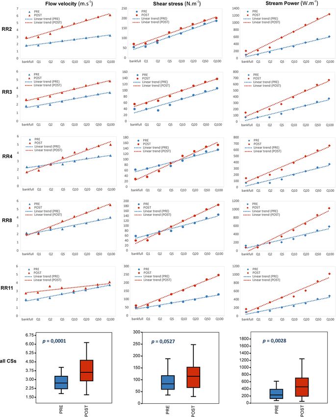
www.nature.com/scientificreports/
bar surfaces. In the GIS environment (ArcMap 10.3), based on visible artificial change in braidplain area (i.e. vis-
ible traces of heavy equipment interventions) 11 river reaches belonging to the Natura 2000 area were indentified
and vectorized on the Belá River.
The shapefile formats of all monitored river reaches, classified into the nine channel landform categories
(i-ix), served as input data for the calculation of Shannon diversity index (aiming to prove changes in geomorphic
diversity) performed with R s oftware34 and the “vegan” ecology package version 2.5-635.
Cross‑section measurement and hydraulic parameter modelling between pre‑ and post‑flood
management periods. The fieldwork campaigns focused on capturing changes in elevation at five cross-
sections (RR2, RR3, RR4, RR8, RR11) in artificially modified river reaches (RR). The changes in cross-section
measurements were determined with a GPS Leica Zeno5 with RTK corrections and vertical and horizontal
accuracy of 30–100 mm for all consecutive cross-section measurements assigned to the period 2017–2019. The
pre-flood management period (2017–2018) before the flood in July 2018 was utilized to capture naturally occur-
ring erosion–accretion processes on expertly selected cross-sections on the studied river reaches. The post-flood
management period (2018–2019) after the 2018 flood and after heavy equipment interventions in the river’s
active zone was used for further cross-section measurements in August 2018 and July 2019.
To calculate the width/depth (W/D) ratio, the bankfull channel width was acquired directly from the cross-
section data collected in the field. Thus in each cross-section, bank edges were indicated at the place of a first
sudden change in the cross-section profile, above which the surface was covered by permanent v egetation36. It
allowed the model to partition a total flood flow into the flows conveyed in the channel and floodplain zones of
the cross-section and to compute given hydraulic parameters not only for the total cross-section but also for its
channel and floodplain parts. Bankfull channel depth was calculated as the average of all measurements taken
at the cross-section in each sampling site.
T-years flood discharges within the study cross-sections (RR2, RR3, RR4, RR8, RR11) were calculated using
the information obtained from Liptovský Hrádok gauging station about values of t-years floods there and addi-
tionally calculations of the catchment area in the vicinity of study cross sections. For discharge value extrapolation
the formula giver by Ozga-Zielińska and Brzeziński37 was applied:
AX n
QX max = QW max (1)
AW
where QX max—discharge at the measured cross-section (m3 s−1); QW max—discharge at the gauging station (m3
s−1); AX—catchment area for the measured cross-section ( km2); AW—catchment area for the gauged cross-section
(km2); n—parameter of the extrapolation equation. Manning’s roughness coefficients for the channel bank and
floodplain parts of the stream cross-sections were chosen in line with the criteria of Chow38 and are changing
along cross section. Also Manning’s roughness coefficients they are different for pre- and post-management
period analyzed in the paper.
The following hydraulic parameters for the measured cross-sections with potential RI (from bankfull to Q100)
were analyzed in the channel zone: flow velocity (m s −1), shear stress (N m −2) and stream power (W m −2). The
constructed hypotheses relate to the impact of river training on the flow velocity for the new artificial geometry
of the main channel. We assumed that a new single-thread channel configuration with artificially high banks
increases flow velocity significantly. Shear stress is a measure of the erosive force of running water in a riverbed.
In comparison with the original morphological configuration of the main channel, higher values were anticipated
as a negative influence of management intervention on shear stress values. For stream power, an increasing trend
of erosive capacity concurrent with increased flow velocity and erosive force is presumed. Measurement of the
W/D ratio39 is valuable for describing channel cross-section shape, and comparison of ratio values can be used
to interpret shifts in channel stability following disturbances to channels. These analyses highlight the role of the
W/D ratio on the degree of asymmetry of the discharge distribution in the channel. A one-dimensional, steady
flow HEC-RAS model in line with Chow38 and Chang40 postulates (where the flow velocity, energy as well as
other hydraulic equations are presented in details) was used41 to determine all analyzed hydraulic parameters
as well as water stages for given flood discharges in the research cross-sections of the Belá River. String models
were created for cross-sections, where the hydraulic gradient was calculated based on cross-sectional geometry,
elevation of successive cross-sections and the distance between them. A mixed-flow regime mode was used for
the modeling. The discharge data were taken from at two water gauging stations on the Belá: the upstream Pod-
banské gauging station and the downstream Liptovský Hrádok gauging station where the stage–discharge curves
were available. Model calibration was done using the findings of Brandimarte and B aldassarre42 and USACE41.
Results
Geomorphological impact of the management interventions. Based on the official documenta-
tion of the SWME, the total length of the planned river training on the Belá River in the Natura 2000 area was
1340 m. GIS analysis proved, that the total length of the realized river training carried out in the form of reloca-
tion and extraction of sediment material was 4823 m. Due to individual assessment of the channel condition
during the constructive works in the field, the official plan was carried out beyond its scope. These facts confirm
that the total length of realized works exceeded the planned works by 360%. However, the appropriateness of
these excessive interventions in realized form remains disputable.
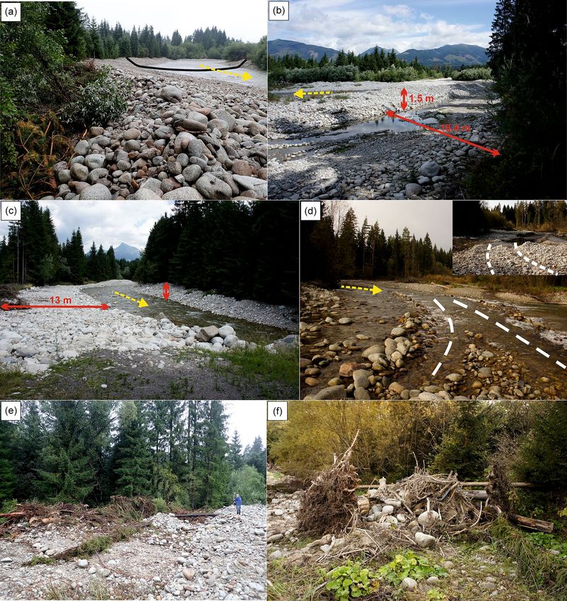
During field reconnaissance, several characteristic examples of the management interventions were found in
the Belá braidplain area (Fig. 2). The river training in RR7 consisted of extraction or shifting of gravel to form a
wide “U”-shaped channel with high banks, i.e. forming a shallow, quasi-artificial channel (Fig. 2A). By carrying
Scientific Reports | (2021) 11:6289 | https://doi.org/10.1038/s41598-021-85805-2 4
Vol:.(1234567890)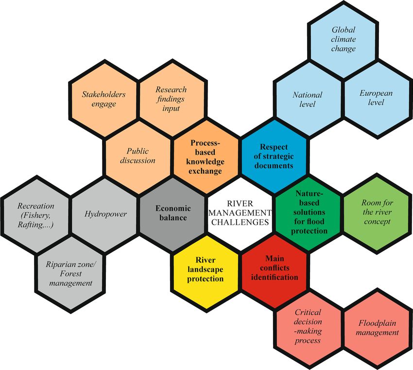
www.nature.com/scientificreports/

                                  Figure 2.  (a) Photographic documentation of how gravel has formed into a wide “U”-shaped channel and (b)
                                  of the artificial formation of backwater surfaces and elevated gravel barriers in the middle of the braidplain area
                                  near Pribylina settlement during field reconnaissance in 2018 and 2019. (c) We recognized the formation of
                                  artificial lateral bar surfaces and elevated gravel banks (marked with red arrows) further upstream at Kokavský
                                  Bridge in RR10. (d) Visible traces of heavy equipment transfer (white dashed lines) at two sites between the
                                  individual treated river reaches between Vavrišovo and Pribylina settlements. (e) On the edges of riverbanks, we
                                  documented the rolling up of large woody debris mass (f) mixed with granite boulders. Yellow arrow represents
                                  the flow direction (photo: Anna Kidová; A, E, F: 13.8.2018; B, C: 17.7.2019; D: 19.10.2018).

                                  out these management interventions, the original multi-thread river system was seriously or completely destroyed
                                  and the water flow was concentrated in a single shallow main channel. Upon the intervention of heavy equipment,
                                  unnatural backwater surfaces with stagnant water arose on the artificial bar surfaces in the river’s active zone
                                  (e.g. RR3, Fig. 2B). The next management intervention example is represented by shifting gravel into the high
                                  banks (Fig. 2C). Uplift of the original left bank line isolated it from the other sidearms on the floodplain. At the
                                  same time, a 13 m-wide artificial bar surface was created where the original 5.2 m-wide lateral bar occurred in

Scientific Reports |   (2021) 11:6289 |                https://doi.org/10.1038/s41598-021-85805-2                                                   5

                                                                                                                                               Vol.:(0123456789)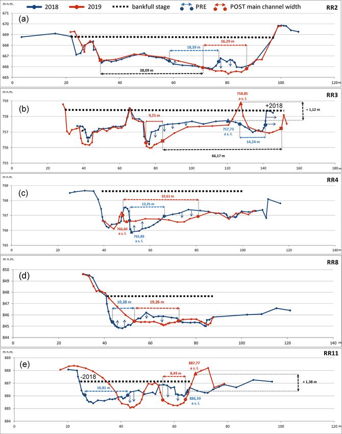
www.nature.com/scientificreports/

          Scientific Reports |   (2021) 11:6289 |   https://doi.org/10.1038/s41598-021-85805-2   6

Vol:.(1234567890)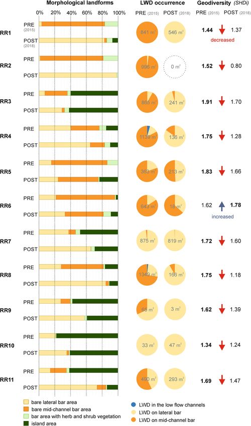
www.nature.com/scientificreports/
◂Figure 3. (a) Example of reduced low flow channels on RR2 near Dovalovo settlement in 2015 with natural
braidplain before management intervention and (b) in 2018 after intervention with an artificially created lateral
bar on both banks of the Belá River generated in ArcMap 10.3 software. (c) Comparison of area of studied
morphological parameters in total for all studied 11 river reaches in the natural (2015) and artificial river active
zones after river training (2018). (d) Differences in the length of low flow channels between 2015 and 2018 in all
studied river reaches (RR1–11). For legend of studied channel landforms for (a), see Fig. 1C. (e) Holiday cottage
at real flood risk (marked by a red arrow) in the seasonally settled “Cottage area 2” (Fig. 1) on the Belá River
floodplain. This risky position of the cottage probably requires management intervention in RR9. Background
ortophoto image is from 2018 and was generated in ArcMap 10.3 software.
the pre-flood management period in RR10. Orthophotos from 2018 as well as field reconnaissance also revealed
well-marked traces of heavy equipment transfer between the individual river reaches in the Belá braidplain
(Fig. 2D). The extent of bottom damage in overall 12 recorded river sites is only indicative, but certainly not
negligible. The river training in the Belá River also included the removal of LWD or rolling of LWD along the
banks or on bars (Fig. 2E,F). LWD residues in the braidplain created wood accumulations (clumps and jams) or
were dispersed at irregular intervals as individual pieces.
Based on a comparison of the area and length of selected morphological parameters (Fig. 3C,D), several
changes in the morphology of the Belá River’s active zone were evident. Although the results indicate that there
has been no significant decrease in the water surface area (low flow channels) after the river training, the data
on the length of the low flow channels, which refine these results, showed the opposite. After adjustments, the
length of the flow channels decreased overall by almost 5 km. The decline was due to the shifting of gravel to the
sides, destroying the original multi-thread pattern and creating a wide, single-thread one (Fig. 3A,B). The area
of artificially created isolated water surfaces (backwater areas) on lateral bars was increased 30 times. There was
a noticeable increase in lateral bar area overall due to the accumulation of gravel from the center of the main
channel to its edges and to the banks, respectively. The area of the mid-channel bar, the most important and
dynamic in-channel landform of a braided-wandering river system, decreased significantly after management
intervention, from 59,015 to 10,313 m2. This intervention in the braidplain area resulted in a decrease in the
bar area with herb and shrub vegetation cover as well, from 10,435 to 7881 m 2. A slight increase in island area
indicates the maintained continuity of vegetation succession.
The four main morphological landforms of the braidplain, bare lateral/mid-channel bars, bars with herb and
shrub vegetation cover, and islands, were evaluated for all studied river reaches (Fig. 4). A specific quantifiable
parameter, the presence of LWD in the braidplain area, was monitored especially in the low flow channels and on
lateral and mid-channel bar landforms (Fig. 4). The equal scenario, with a significant decrease of the mid-channel
bar area as well as a significant increase of the lateral bar area on all river reaches (RR1-9, RR11), prevailed. On a
prevailing number of river reaches (RR1, RR2, RR4, RR5, RR11), vegetated bars with herbs and shrubs decreased
in area after river training. The original island area occurred on seven river reaches in 2015. On six river reaches
(RR4, RR7, RR8, RR9, RR10, RR11), island area decreased and only on two did it increase in 2018 (RR3, RR6).
On two river reaches (RR1, RR5), a brand-new island area arose after management interventions.
The presence of LWD accumulations reduced significantly after river training in the Belá braidplain, from
7666 to 2482 m 2 in total. We noticed a very significant decrease in LWD especially in mid-channel bars (from
5676 to 168 m 2 in total), of which the lateral ones were artificially created. However, we registered only a slight
increase (about 395 m2 in total) in LWD between 2015 and 2018 on lateral bars as well. LWD occurrence in 2018
prevailed in lateral bar areas (RR1, RR3, RR4, RR7-11) in comparison with the prevailing occurrence in 2015 on
mid-channel bars. On two river reaches (RR4, RR8), we registered natural occurrence of LWD also in low flow
channels. Calculation of geodiversity status (Shannon diversity index) proved a decreasing trend in geomorphic
diversity for 10 river reaches after river training. We registered the largest difference (decrease) in geodiversity
status between pre- and post-flood management periods mainly for RR2 (− 0.72) and RR8 (− 0.57).
Morpho‑hydraulic dynamics in cross‑sections. Repeated individual cross-section measurements after
river training and modification of the Belá River braidplain revealed significant reductions in the flow depth
in all cross-sections (Table 1, Fig. 5). The morphological structure (bar, island, low flow channels, artificial bar
surface) of these cross-sections are summarized in Table 1 for the pre- and post-flood management periods.
The first cross-section RR2 (Fig. 5A) is situated in the village of Dovalovo (urban part of the town of Liptovský
Hrádok). The original multi-thread pattern was destroyed across its entire width. The original main channel
was transferred from the central part to the left side of the braidplain, while two original island landforms were
removed. The width of the artificial bar surface was 38.09 m, representing two-thirds of the total width of the
river’s active zone at this cross-section.
Cross-section RR3 (Fig. 5B) is located in the settlement of Pribylina. On the left side of the river’s active zone, a
66.17 m-wide artificial bar surface was formed. The top of this artificial bar surface (in the form of a dike) exceeds
the original top of the mid-channel bar by 1.12 m (Figs. 2B and 5B). This cross-section is further characterized
by a reduction of the erosion base of both the main and side channels by about − 0.5 m. The position of the main
channel was artificially shifted to the center of the braidplain, reducing its width and depth.
The third cross-section RR4 (Fig. 5C) is situated under the road bridge between the settlements of Pribylina
and Liptovská Kokava. At the cross-section, the bottom of the main channel was levelled and raised by 0.71 m.
The main channel was artificially extended from the original 13.25–32.61 m, while the original mid-channel
bar was removed.
Scientific Reports | (2021) 11:6289 | https://doi.org/10.1038/s41598-021-85805-2 7
Vol.:(0123456789)www.nature.com/scientificreports/
Figure 4. Differences in the morphological landform area of the braidplain, geodiversity status (increased/
decreased SHDI) and comparison of LWD accumulation area in PRE-flood (2015) and POST-flood
management periods (2018) in all studied river reaches (RR1–11). Numbers inside a pie chart represent the total
area of LWD accumulation identified in monitored river reaches.
Cross-section RR8 (Fig. 5D) is located near the right-side tributary of the Bystrá creek to the Belá River. At
this cross-section, on the right side of the river’s active zone, there was massive accumulation of gravel material
Scientific Reports | (2021) 11:6289 | https://doi.org/10.1038/s41598-021-85805-2 8
Vol:.(1234567890)www.nature.com/scientificreports/
Number Grain
Ø Depth
No. of Management Date of CS of low size Morphological structure W/D
(m) of
CS period measurement flow D50 of cross-section ratio
MCh
channels (φ)
Pre 08.06.2018 3 0.44 F-RB-SCh-LaB-I-MCh-O-SCh-LB-F 27,65
RR2 -6.901
Post 18.07.2019 1 0.36 F-RB-ABS-MCh-ABS-LB-F 23,18
Pre 05.06.2018 2 0.37 F-RB-LaB-SCh-LaB-I-LaB-MCh-LB-F 95,25
RR3 -6.808
Post 17.07.2019 2 0.23 F-RB-LaB-SCh-I-MCh-ABS-LB-F 50,90
Pre 05.06.2018 3 0.52 F-RB-SCh-I-MCh-CL-VK-LB-F 52,37
RR4 -5.765
Post 16.07.2019 2 0.34 F-RB-SCh-ABS-MCh-LaB-LB-F 89,23
Pre 13.07.2017 2 0.46 F-RB-MCh-CL-SCh-LB-F 18,36
RR8 -6.847
Post 15.08.2018 2 0.16 F-RB-ABS-MCh-MChB-SCh-LB-F 19,74
Pre 11.07.2017 2 0.44 F-RB-MCh-LaB-I-SCh-LB-F 25,74
RR11 -7.209
Post 16.07.2019 2 0.32 F-RB-ABS-SCh-ABS- MCh-LB-F 20,73
Table 1. Selected morphological parameters (number of low flow channels, depth of main channel),
morphologic structure (in the right to left order) and W/D ratio of monitored cross-sections on river reaches
where the river training was realized (Pre: before the flood event in July 2018; Post: after the flood event in July
2018 and management intervention). Median grain size (D50) of the sediment material was measured on gravel
bars as well as under the water on the main and secondary channels based on W olman43 approach. CS cross-
section, RR river reach, F floodplain, RB right bank, LB left bank, MCh main channel, SCh secondary channel,
LaB lateral bar, MChB mid-channel bar, I island, ABS artificial bar surface).
and filling of the original 10.28 m-wide main channel. New artificial 19.26 m-wide and shallow (0.16 m average
depth) main channel was created (Table 1).
Cross-section RR11 (Fig. 5E) is located upstream on the Belá River, above the Kokavský Bridge site. Piled-
up gravel on the right bank caused destruction of the original 16.81 m-wide main channel. By adding gravel on
the left bank, the original bank height increased by 1.38 m. A new 8.49 m-wide main channel was artificially
created on the right side of the river’s active zone. The management intervention raised the riverbanks, notably
increasing the isolation of the main channel from the surrounding floodplain.
The cross-section measurements of the modified river active zone on selected river reaches (RR2, RR3, RR4,
RR8, RR11) clearly demonstrate several negative effects on the original morphology of the Belá River. We reg-
istered simplification of the multi-thread river pattern, artificial shifting of the main channel’s position and the
formation of uniform morphologically undifferentiated anthropogenic forms (artificial bar surfaces) in the river’s
active zone, as well as isolation of the main channel from the surrounding floodplain by artificially raised banks.
The changes in cross-section geometry caused by the management disturbance were also naturally reflected in
the values of the W/D ratio. We registered a different W/D ratio for pre- and post-flood management periods
for all measured cross-sections. These values proved the most significant asymmetry of the river’s active zone in
the discharge distribution in cross-sections RR3 and RR4 (Table 1).
Average values of hydraulic parameters for the five studied river cross-sections at eight flood discharges of
given RI (bankfull, 1-, 2-, 5-, 10-, 20-, 50- and 100-year) were compared and the statistical significance of differ-
ences between two types of cross-section (pre- and post-flood management period) was determined (Fig. 6). For
the first hydraulic parameter monitored, an increase in flow velocity in the modified main channel was docu-
mented for all cross-sections. Overall differences in flow velocity in all cross-sections were significant according
to the Mann–Whitney test (p = 0.0001). For the shear stress parameter, we documented a clear increase in erosive
force from 5- to 100-year RI in all cross-sections in the post-flood management period. Overall differences in
shear stress in all cross-sections were on the borderline of significance according to the Mann–Whitney test
(p = 0.0527). Analysis of the stream power parameter demonstrated its higher values of the erosive capacity of
sediment transport during the post-flood management period in all cross-sections. The much intensive erosive
capacity shows in higher RI values mainly, hence the much more eroded material during high flood events is
expected. This trend reflects the significance value of the Mann–Whitney test as well (p = 0.0028). The higher
amounts of transported sediments support the accumulation zones increasing as well.
Discussion
Morphological and hydraulic impact of the management intervention. The management inter-
vention in the Belá River’s active zone was demonstrated by the creation of wide “U”-shaped shallow channels,
artificial bar surfaces (lateral bar areas) and high banks. New (artificial) morphological landforms of accumu-
lated LWD mixed with gravel originated as well. The passage of heavy equipment through the riverbed used to
move from one planned treatment river reach to another caused disturbance of the river bottom and deforma-
tion of gravel bars. Its impact on the bottom cohesion of the Belá River increased the water energy, i.e. its drifting
ability, thus increasing the risk of channel incision12 into the easily erodible flysch bedrock (sandstone and clay-
stone). Reducing the erosion base (by incision) can disrupt or even completely disrupt the hydromorphological
connectivity of the main channel with the secondary channels in the transverse direction. We ascribed a similar
effect to the formation of high banks. The functional, structural and hydrologic c onnectivity44,45 between the
channels in such a floodplain is important mainly to preserve the typical multi-thread pattern of the Belá River.
Scientific Reports | (2021) 11:6289 | https://doi.org/10.1038/s41598-021-85805-2 9
Vol.:(0123456789)www.nature.com/scientificreports/
Figure 5. Geometry of cross-sections on the selected river reaches (a) RR2, (b) RR3, (c) RR4, (d) RR8, (e)
RR11 on the Belá River where river training were carried out. The blue cross-section represents the reference
state (PRE) of the river before the flood in July 2018; the red cross-section represents the state after this flood
event and river training during August 2018 (POST). At each cross-section, the width of the main channel (m)
is marked (red and blue numbers). Bankfull stage at each cross-section reflects measured bankfull width where
value ± 2018 points out differences in width between pre- and post-flood management periods. The direction
of the arrows marked in cross-sections represents surface modification of the river’s active zone during river
training.
Scientific Reports | (2021) 11:6289 | https://doi.org/10.1038/s41598-021-85805-2 10
Vol:.(1234567890)www.nature.com/scientificreports/
Figure 6. Hydraulic parameters calculated in measured cross-sections (CSs).
Vehicles crossing the channel resulting in the destruction of bed armoring has also been pointed out on the Raba
River in the Polish Carpathians46.
The presence of LWD in the riverbed has a significant geomorphological e ffect47–49, especially in reshaping
in-channel morphology (e.g. sediment transport) as well as lateral migration of the riverbed (e.g. bank erosion,
avulsion). By its size or position in the channel, LWD creates a barrier to flow and/or initiates trapping of finer
sediments, accelerating vegetation cover formation processes50. It is highly probable that the unsystematic reloca-
tion of gravel and LWD on the edge of river banks and on gravel bars has led to disturbance and destruction of the
Scientific Reports | (2021) 11:6289 | https://doi.org/10.1038/s41598-021-85805-2 11
Vol.:(0123456789)www.nature.com/scientificreports/
original fauna and flora biotopes that are included in Natura 2000 (e.g. Myricaria germanica) due to eradication
of the geomorphic features, such as pools and r iffles51 and reduction of their bio-geomorphological f unction52–54.
The riparian zone of the Belá River represents the best-preserved riparian forest stands with German tamarisk
Myricaria germanica in Slovakia. The last biomonitoring carried out by The Slovak Nature Conservancy in 2019
revealed that this biotope is currently in 25% of the inconvenient state, in 50% of bad conditions, and only in
25% of the favorable state due to management intervention in 2018. The irregular and unsystematic relocation
of gravel with LWD outside of the river’s active zone or its removal from the mid-channel part to the nearest
bank destroyed the original biotopes of fauna (macro- and microfauna). The results of the inventory survey on
the Belá River carried out by the Slovak Fishing Association, after river training in October 2018, confirmed
damaged fish biotopes with affected species composition, abundance, and the age structure of the ichthyofauna.
According to the recorded results, the estimate of fish mortality due to the implemented flood control measures
reached 15–20%. Besides that, the new position of LWD near bank lines could lead to greater bank stabilization
due to the bank armoring effect.
The actual global problems of climatic change55,56 related to water deficiency (drought) or flash floods, as
well as decreasing bio- and geodiversity57,58, are alarming for society and have an impact on many decisions and
attitudes of policymakers. For river systems in the European region, the WFD (2000/60/EC) represents the basis
for river management optimization and the focus of its ecological quality improvement activity until 2027. The
WFD in Annex II requires the identification of significant morphological changes in water bodies. Elements
defining morphology include variation in the depth, width, structure and substrate of the riverbed and structure
of the riparian zone. Disturbed natural river morphology affects the habitats of aquatic plants and animals and
can therefore have an impact on aquatic ecology. The ability for adaptation and flexibility in river management
is necessary for the sustainable development59 and protection of unique river landscapes.
We demonstrated changes in channel morphology and flow hydraulics by hydraulic simulation for the studied
river cross-sections. As far as uncertainty of numerical modeling is concerned, hydraulic conditions in rivers
are usually complex flows but they can be analysed with use of 1D or 2D modelling60–62. Whilst 1D approach
is often considered a gross simplification of the flow field63, one can justify the approach by assuming that the
approximations involved in treating out-of-bank flow as one-dimensional are small compared to geometry in
the incised and multi-thread r eaches64,65. As demonstrated by Horritt and B ates61 for a 60 km reach of the River
Severn, UK, one-dimensional models performed equally well. Importantly, the approach allowed us to obtain
the detailed river geometry in the studied cross-sections and to extend the study to a completely considered river
reach. The chosen flood magnitude discharges (from bankfull to 100-year RI) more precisely reflect the whole
scale of the potential morphological effect after management intervention. The documented increases in flow
velocity, shear stress and stream power for all studied cross-sections on the Belá River (Fig. 6) reflect the river
system’s response to the new morphological settings within the modified main channel (post-flood manage-
ment period), which might result in accelerated erosion of the riverbed39. The increased values from bankfull
discharge to 100-year RI of shear stress from 1.93 to 33.37% and stream power from 36.26 to 83.57% in average
of all measured cross-sections correspond to reduced multi-thread channel configuration with mid-channel
bars occurrence. The resulted artificial created shallow main channel with lateral bars along river banks decrease
the width–depth ratio due to decreased width of the initial channel. Our findings confirmed arguments that
the channels with large width–depth ratios will braid through the development of multiple bar-unit structures
across the width of the channel, whereas constraints on adjustment in width–depth ratio result in meandering
or even straight channels66.
The synergistic effect of management interventions such as channel straightening, pattern simplification or
lateral connectivity disruption has led to a significant decline of geodiversity on the Belá River but also to reduced
ability of the river system to mitigate flood discharges. In the Carpathian region, increased values of shear stress,
as well as stream power, have been documented on managed river reaches in comparison with unmanaged ones
on the Raba River in the Polish C arpathians67. Analyses of the stream power in the multi-thread cross-sections
of the Czarny Dunajec River also revealed lower values in comparison with the channelized ones as well (from
3.3 times at a 1.5-year flow to 4.5 times at a 50-year flood)68. A similar trend in the Czech Carpathians proves
increasing stream power values for higher-magnitude flow events (5-, 20-, 50-, 100-year RI) on the gravel-bed
Olše River after channel transformation due to c hannelization69. Another confrontation with modelled flow
hydraulics on the re-naturalized multi-thread patterns of the Bečva River refers to the detection of lower unit
stream power v alues70. These findings clearly correspond with our hypothesis linked to channel adjustment
in the post-flood management period. All research hypotheses were confirmed: flood wave mitigation on the
floodplain was minimized and erosive force in the main channel increased. On the other hand, these facts in the
context of flood risk brought unsatisfactory results.
Identification of the main conflicts of the Belá River management. This paper aims to draw atten-
tion to the disharmony between the content of strategic documents and the engineering approach to river man-
agement for the protected area (Natura 2000) through the objectiveness of geomorphological and hydrologi-
cal assessment. Nowadays, several studies reflect prioritizing an integrated and holistic approach71–73 before an
engineering one. Another effective approach is represented by adaptive management74,75 based on the systematic
process of simulation models to test hypotheses that reflect different interpretations of how river processes work.
The official document of Slovakia’s water plan from 2015 for river basin management, a comprehensive tool for
setting objectives and measures for the Danube basin in which the Belá River is located, extended the identifi-
cation and analysis of the significance of transverse disturbances to connections of wetlands and inundations
(floodplains) on all water bodies for the second plan period (2016–2021). Equivalent priorities, linked to the
prevention of further deterioration of water status when planning new projects that may cause new hydromor-
Scientific Reports | (2021) 11:6289 | https://doi.org/10.1038/s41598-021-85805-2 12
Vol:.(1234567890)www.nature.com/scientificreports/
phological changes in the body of surface water in accordance with the provisions of Article 4 (Section 7) of the
WFD, are mentioned in another strategic document, the “Proposal of orientation, principles and priorities of
water management policy for the Slovak Republic until 2027”. The orientation of water management policy refers
to the use of green infrastructure and the opening/restoration of natural floodplains, especially in the zone out-
side municipalities, as one of the preventive measures for flood protection. On the contrary, solutions for river
channels in the urban area of municipalities are linked to technical measures using so-called “grey” infrastruc-
ture, in particular, due to the limited space between the stream and existing buildings, where using the elements
of “green” infrastructure is not possible or insufficiently efficient. As Kidová et al.15 pointed out, the Belá River
has a near-natural character. From a management point of view, the spatial distribution of settlements along the
banks of the Belá River is generally sparse. In the first 5 rkm from the confluence of the Belá River with the Váh
River, there are the settlements of Liptovský Hrádok and Dovalovo, protected by dike construction and several
stony grade-control structures. The next settlement on the Belá River is Pribylina, protected by bank reinforce-
ment. The Vavrišovo camp and cottage area situated near the Hrdovo and Kokavský Bridge spot upstream on the
Belá River is seasonally occupied by people, mainly for recreation purposes. Cottage area 2 (Fig. 1) represents
management intervention along RR9 due to location of the cottage very close to the right bank of the Belá River
(Fig. 3E). Flood protection is necessary in areas inhabited all year round as well as seasonally, for logical rea-
sons. Although the cottage area is situated on the river terrace of the Belá, the human impact should be better
managed in this area, for instance by restricting permits for the construction of cottages near the riverbanks. In
contrast, the opposite left floodplain area provides sufficient room for flood overflow discharges and represents
a suitable river reach in terms of the “room for the river” concept76.
Evidently, the hydromorphology of the Belá River as part of the Natura 2000 protected area has changed as
a result of post-flood management intervention in 2018 under the responsibility of SWME. In general, specific
artificial bar surfaces were created and the braidplain was isolated from the floodplain. The proposed Natura
2000 management recommendations for the Belá River (SKUEV0141) relate to the revitalization of the braid-
plain by the restoration of abandoned channels and side arms for the purpose of wetland habitat (floodplain)
inundation30. The principles of care for non-forest habitats of European importance such as fresh water habitats
and their non-forest riparian vegetation are represented by preservation of the nature of the stream, including
the amount and speed of water flowing in the riverbed, water quality (prevention of pollution and eutrophica-
tion) and preservation of unregulated river banks. In gravel-bed streams such as the Belá River, it is necessary
to ensure the process of transformation or moving of gravel bars during floods and to create conditions for the
preservation and restoration of the Br3 habitat (Mountain freshwaters and their woody vegetation with Myricaria
germanica). Moreover, regulation of gravel extraction is necessary. The priority to maintain and improve the
situation in the territory of the Belá River is low to medium. However, presented human interference on the Belá
River is clearly in contradiction with the proposed management recommendations. Furthermore, the guidance
document devoted to the identification and designation of heavily modified (HMWB) and artificial water bodies
(AWB)77 interprets the management intervention performed on the Belá River as a significant anthropogenic
pressure which disrupts the river continuum and causes alteration of the hydraulic regime due to straightening,
as well as having an impact on its hydromorphology. According to all the above mentioned arguments, the post-
flood management approach on the Belá River was chosen incorrectly. This evident non-compliance with the
strategy documents has caused public nuisance for inhabitants in settlements linked to the Belá River and evoked
discussion about the consequences and correctness of the chosen management procedure among experts as well
as non-government organizations and ecological activists (Fishing Union, Association of Limnology, Association
of Slovak Geomorphologists, World Wide Foundation), resulting in the preparation of a memorandum for their
cooperation. After all, in summer 2018 after river training, the Belá WILDRiver was officially removed from the
European Wilderness Network, interpreted as a practical consequence.
The lack of a linked decision process between stakeholders and research findings on the basis of geomor-
phological and sedimentological studies was evident in the Carpathian region two decades ago. The indication
of weak points in the engineering approach to channelization pointed out by Wyżga46 refers to criticism of the
general application of empirically derived formulas for bedload transport that may lead to significant errors
in predicting the bedload transport rates in a channelized river and hence to its instability. S urian11, looking
at examples of braided gravel-bed rivers in northern Italy, noticed that for river management it is necessary to
recognize the effects of channel adjustments on structures and the environment as well as understand the causes
of morphological changes.
Existing documentation for management program of the Belá River for the period 2018–204778 is focusing
mainly on setting operational objectives in relation to ecologically functional zones represented by specific
protected habitats of fauna and flora. The complex river management is missing at all. Hence, there is a strong
need for integrated management and consensus between water management, forest management and nature
conservancy. A lack of appropriate river management of the Belá River resulted from our study as well. The key
challenge from this point of view is engagement activities in knowledge exchange among stakeholders, research-
ers and public as well as involve local communities in the decision-making process as far as possible by sharing
evidence, listening to the ideas and assessing priorities. The challenge of sustaining Belá River in the face of
climate change raised as additional issues to respect all strategic documents where support their implementa-
tion lead to greater enforcement of existing regulations. The need for better-integrated planning focusing on
economic balance to provide multiple benefits to water users (e.g. recreation, hydropower) is crucial to achieving
environmental improvements. The importance of wider landscape management and the value of looking at river
landscape as an entire system emphasizes attention to protection purposes. Further operative step within these
challenges tends to flood risk management coordination with planning the environmentally friendly or nature-
based approaches (e.g. room for the river concept). The importance of the main conflict identification based on
revealing the management operating shortages support redirection of future activities in the more appropriate
Scientific Reports | (2021) 11:6289 | https://doi.org/10.1038/s41598-021-85805-2 13
Vol.:(0123456789)www.nature.com/scientificreports/
Figure 7. River management challenges scheme suggested by authors reveals the main areas for improvement
the management strategy for the Belá River.
way. Then, our suggested compilation of the main management challenges (Fig. 7) for the future is improving
the sustainable development of river systems generally not only for the Belá River as part of the Natura 2000
Network case study. On the other hand, we are realizing that further investigation in these issues and more
detailed analyses according to a good examples from practice (e.g. from E ngland79) is needed.
Although the actual national document from 2019, the Strategy of the Environmental Policy of the Slovak
Republic until 2030, promises more responsible water management and a focus on the revitalization and re-
naturalization of watercourses and the adjacent riverine landscapes, in the sense of WFD, the question of how
Slovakian river managers will deal with the deadline to achieve good water status by 2027 by implementing the
practice is still unanswerable.
Conclusion
The presented intervention in the braidplain area of the Belá River resulted in an undesirable simplification of
the river pattern, loss of geomorphic diversity, loss of channel–floodplain connectivity, and disturbance and
restraint of hydromorphological continuity. The increased flow velocity, shear stress and stream power recorded
for all studied cross-sections on the Belá might result in accelerated erosion of the riverbed in the near future39.
Moreover, the destruction of Natura 2000 Network habitats (aquatic and terrestrial) is presupposed as well as
interruption of the bio-geomorphological effect of LWD.
The geomorphic r ecovery10,45 of the Belá River with a typical multi-thread pattern as well as the richness and
diversity of habitats (geodiversity) after river training is desirable. Natural restoration of the transverse continu-
ity of the main channel with the secondary channels on the floodplain can be expertly estimated in the context
Scientific Reports | (2021) 11:6289 | https://doi.org/10.1038/s41598-021-85805-2 14
Vol:.(1234567890)You can also read