Ryegate Town Plan 2018 - Adopted October 8, 2018 - Northeastern Vermont Development ...
←
→
Page content transcription
If your browser does not render page correctly, please read the page content below
Ryegate Town Plan 2018

             Adopted October 8, 2018
This plan was produced with assistance with Northeastern Vermont Development Association and was funded
by a Municipal Planning Grant from the Vermont Department of Housing and Community Affairs.
Ryegate Planning Commission, 2018
Fremont Nelson, Chair 584-3667
Mary Dole
Alice Allen
Nancy Perkins
Richard Colby II
Walter Bragg
Catherine Davie, Secretary
Stephen Genereaux, M.D.
Regina Hazel

Photos, unless otherwise credited, are provided by Chariot Arts of Woodsville, NH.

TABLE OF CONTENTS

1. Introduction ........................................................................................................................................................................................... 2
2. Land Use ................................................................................................................................................................................................. 9
3. Transportation ..................................................................................................................................................................................... 18
4. Flood Resilience ................................................................................................................................................................................... 22
5. Utilities and Facilities ........................................................................................................................................................................... 29
6. Educational Facilities............................................................................................................................................................................ 33
7. Adjacent Towns and The Region .......................................................................................................................................................... 37
8. Energy .................................................................................................................................................................................................. 40
9. Housing ................................................................................................................................................................................................ 51
10. Economic Development ..................................................................................................................................................................... 53

APPENDICES:

APPENDIX A: PLAN MAPS

APPENDIX B: SUPPLEMENTAL ENERGY DATA AND METHODOLOGIES

APPENDIX C: DESIGNATED VILLAGE CENTERS PROGRAM BENEFITS

Draft 2018 Plan                                                                                                                                                                                     Page 1
1. INTRODUCTION

The purpose of this plan is to guide the citizens of Ryegate in making decisions with foresight
and flexibility. This Plan looks back at our history, presents information about our present, and
attempts to predict our future needs. By doing this, we hope to identify some long-range goals
and plans for future growth, seeking balance between preservation of the town’s aesthetic
beauty and the need to respond to inevitable change.

    WHY HAVE A TOWN PLAN?                               While the Town of Ryegate may receive party
                                                        status in the Section 248 review process, the
    There are several compelling reasons. It            PUC only been obligated to give the municipal
    establishes a long-term guide to support            plan “due consideration” (which is not defined
    decision making on public policy and                in statute) when determining if the proposed
    investments. It also:                               energy project will not unduly interfere with
    • establishes a legal basis for zoning and flood    development. In 2016, Act 174 established a
      hazard regulations.                               new set of municipal energy planning standards,
                                                        which if met, would allow a municipal plan to
    • makes the Town more competitive in                receive “substantial deference” in the Section
      applying for grants for public and community      248 review process. Unlike “due consideration,”
      development investments. (In some grant           “substantial deference” is codified in statute to
      programs, having a current town plan is           mean:
      required.)
                                                        “…that a land conservation measure or specific
    • allows Ryegate to participate in tax incentive    policy shall be applied in accordance with its
      programs, such as Village Center                  terms unless there is a clear and convincing
      Designation (this is described in greater         demonstration that other factors affecting the
      detail in Appendix C).                            general good of the State outweigh the
    • gives the Town a voice in the Act 250             application of the measure of policy.”
      development review processes, as well as the      This plan has been prepared with the standards
      Section 248 process for siting energy             required to receive Substantial Deference in
      infrastructure.                                   mind. The Planning Commission intends to
    Energy generation projects connected to the         amend the plan by developing more substantive
    transmission grid are exempt from zoning and        siting standards before seeking certification for
    fall under the jurisdiction of the Public Utility   Substantial Deference.
    Commission (formerly known as the Public            Numerous individuals and groups provided
    Service Board). According to Section 248 of         comments on sections of the original Plan.
    Title 30, applicants must first obtain a            During the adoption process, the residents of
    Certificate of Public Good (CPG) from the PUC       Ryegate and adjoining towns were invited to
    before beginning site preparation or                two public meetings to give their comments.
    construction of electric transmission facilities,
    electric generation facilities and certain gas
    pipelines within Vermont.

Draft 2018 Plan                                                                                         Page 2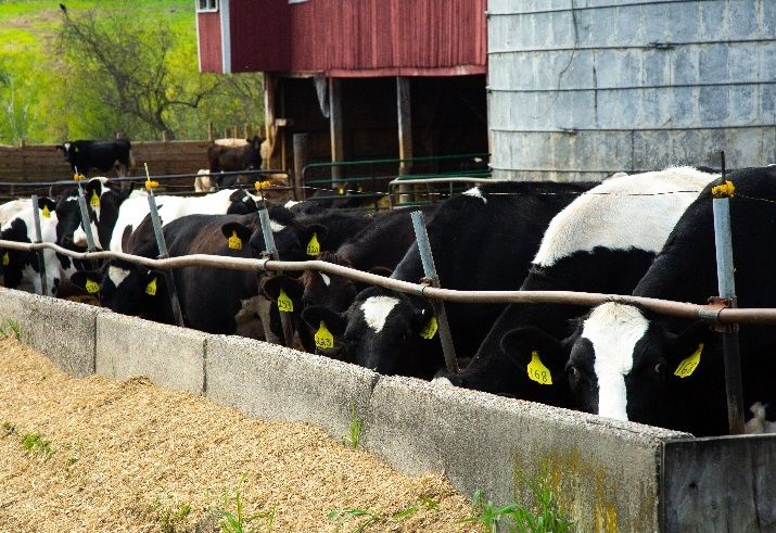
A BRIEF HISTORY OF RYEGATE 1 Richard Jeness and 93 associates on September
8, 1763. This was the town’s first speculative
With the Connecticut located to along the east, real estate transaction. None of the 94 grantees
and numerous ponds and streams located to the ever saw the land before it was conveyed for
to the west, the town of Ryegate was once a one thousand pounds to John Church of
critically important landscape for Native Charlestown, New Hampshire in 1767. Church
American peoples. Native American later sold the tract to Reverend John
archaeological sites dating from the Late Witherspoon, President of Princeton College.
Archaic period, ca. 6,000 – 3,000 years ago,
through to the time of European contact and In 1773, James Whitelaw and David Allen,
beyond have been documented in Ryegate, and agents of the Scotch-American Company,
many more likely remain undiscovered. purchased the town from Dr. Witherspoon.
Whitelaw’s survey of the area remains the basis
Benning Wentworth, governor of the Province of local property boundaries. In his report to the
of New Hampshire, chartered 23,040 acres in Scottish investors, he marveled at the fertility of
the southeast corner of Caledonia County to the soil, the abundance of fish in the streams,
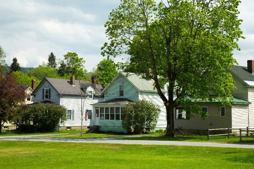
The first buildings in Ryegate were along the Bayley-Hazen Road at Ryegate Corner, the only public highway
connecting the Wells River Valley with Barnet, Peacham, and Danville. Ryegate Corner (above) is still in many
ways the center of town.
1
Much of this section comes from History of Ryegate
Courtesy of Dwight White
Draft 2018 Plan Page 3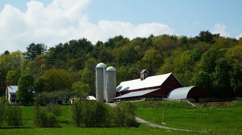
and the availability of waterpower for sawmills.     products, lumber, grain, and thousands of bricks
                                                     were shipped out of East Ryegate.
According to the New Hampshire Historical
Society, the town was named Ryegate in honor         Pulp was shipped into the paper mill in East
of Baron Reigate, a leading British naval figure     Ryegate beginning in 1906, and millions of
and Royal Governor of Jamaica.                       pounds of paper were shipped out. From the
                                                     time it began operation until it closed for the last
Ryegate’s first Town Meeting was held in May
                                                     time in 2001, the paper mill was one of the
of 1776, the first child was born in 1774, and the
                                                     important industries in town. At various points it
first marriage took place in January of 1777.
                                                     produced high-grade news print, ribbon stock,
The first buildings were along the Bayley-Hazen
                                                     light weight catalog, photo mount, and tablets,
Road at Ryegate Corner, the only public
                                                     to name a few. At its high point in the mid
highway connecting the Wells River Valley
                                                     1900s, employment rose to 140.
with Barnet, Peacham, and Danville. A mail
route was soon established along this route, and     In South Ryegate, the railroad allowed the
the first Ryegate Postmaster was General James       development of the granite industry. Quarries on
Whitelaw.                                            Blue Mountain and White’s Hill supplied
                                                     finishing sheds in the village. The quarries
The first school was at the site of what is now
                                                     gradually gave way to a superior grade of
Blue Mountain Grange Hall. The town was later
                                                     granite coming from the Barre area and closed
divided into ten school districts. In 1914 and
                                                     down completely in the 1930s. The Blue
1915, a two-year high school was operated in
                                                     Mountain Quarry reopened briefly from 1986 to
South Ryegate. The District Schools were
                                                     1991 and then, in May of 1993, McCullough
gradually phased out until only South Ryegate,
                                                     Crushing purchased it from the Small Business
Ryegate Corner, and East Ryegate had grade
                                                     Administration.
schools, with high school students attending
schools of their choice in surrounding towns. In
1970 the Blue Mountain Union School was built
for students K-12 from the towns of Ryegate,
Groton, and the Village of Wells River.
Ryegate may be the only town in Vermont that
has had only Presbyterian churches since its
charter. The first church, built in 1779, stood in
Ryegate Corner at the site of the current Town
House. This Church was used by both
Associated and Reformed (Covenanter)
Presbyterians. Through the years, dissident
groups broke away and constructed churches in
Ryegate Corner, South Ryegate, and East              Agriculture has played an important role in the
Ryegate. The East Ryegate church is now              history of Ryegate. The early farms were largely
owned by the Historical Society.                     subsistence operations, but sold their surplus
Railroads were an important factor in the            butter, lumber, and beef to purchase goods,
growth and development of Ryegate. The               which could not be made on the farm. They also
Connecticut and Passumpsic River Railroad            produced large families of sturdy citizens, who
began its route to St. Johnsbury in 1850, and the    have made their mark on the town and on many
first train of the Montpelier and Wells River        other towns in this county. Agriculture
Line traversed the Valley in 1873. Farm              continues to play an important role in the
                                                     economy and landscape of the town. Farms are

Draft 2018 Plan                                                                                    Page 4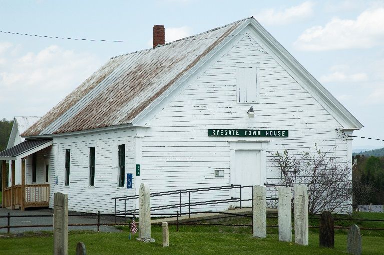
now fewer, larger, and more mechanized.                 enterprises that provide its residents with local
                                                        employment opportunities, as well as essential
Construction on the Ryegate Wood Energy
                                                        goods and services, including daycare.
Plant on Route 5 in East Ryegate began in 1991.
The plant, completed in November of 1992,               Ryegate is a model for climate resilience and
provides about 75 jobs and a market for some of         environmental sustainability. We are committed
the low-grade timber, which is so plentiful in          to making the most of our natural flood
the area.                                               attenuation assets, such as floodplains and
                                                        wetlands. As climate change challenges and
For those interested in an extensive and most
                                                        alters our traditional land- and recreation-based
interesting account of the history of Ryegate,
                                                        economies, we will identify new enterprises that
two volumes are recommended. The first is a
                                                        are compatible with our rural tradition. We will
History of Ryegate, Vermont 1774-1912 by
                                                        minimize our carbon footprint through
Edward Miller and Frederic P. Wells, published
                                                        weatherization and efficiency initiatives, and by
in 1913, which can be found on the town’s
                                                        replacing the use of fossil fuel with renewable
official web site: www.ryegatevt.org
                                                        resources, where feasible.
Its sequel, The Down of the Thistle - 20th
                                                        Ryegate’s traditional development patterns will
Century Ryegate, Vermont, was written by
                                                        be preserved by revitalizing existing centers of
Dwight A. White and published in 2006.
                                                        development to establish a vibrant mix of
                                                        quality housing options, businesses, community
THE VISION FOR RYEGATE
                                                        activities, civic functions, and greenspaces. We
                                                        will also preserve our community’s historic
Ryegate is a rural community that supports its          elements.
working lands through diversified agriculture           In keeping with our community’s rural nature,
and forestry-based enterprise. We strive to             Ryegate prioritizes and supports land-based
balance the needs of the community with a               recreation, such as hiking, cross-country skiing,
commitment to sustainability and best                   cycling, and hunting.
management practices.
Ryegate supports light industry and home-based

    MAINTAIN, EVOLVE, TRANSFORM

    To support Ryegate’s vision, we will pursue the following priorities over the next eight years
    within the following timeframes: short-term (1-2 years), mid-term (3-5 years), long-term (5-8
    years)

    MAINTAIN THE SCENIC AND RURAL BEAUTY OF RYEGATE’S WORKING LANDS AND NATURAL
    LANDSCAPES.

        •   Establish and support the efforts of a Recreation Committee. (short-term; Resource:
            Vermont League of Cities and Towns)
        •   Identify and map scenic road segments. (mid-term; Resource: Municipal Planning Grant
            Program)
        •   Establish a wellhead protection overlay. (mid-term; Resource: Vermont Rural Water
            Association)

Draft 2018 Plan                                                                                      Page 5
•   Complete a Land Evaluation Site Assessment to support and prioritize conservation
        efforts. This technique, which involves rating lands based on their physical soil
        characteristics and other locally defined criteria, can be used to prioritize and support
        land conservation efforts for entities such as the Vermont Land Trust and the Vermont
        Housing & Conservation Board. (long-term; Resource: Municipal Planning Grant
        Program)
    •   Seek the technical support of conservation organizations to establish a town forest and
        parks. (long-term; Resources: Conservation organizations, land owners)

EVOLVE RYEGATE’S TRADITIONAL CENTERS OF DEVELOPMENT – SOUTH RYEGATE, EAST RYEGATE,
AND RYEGATE CORNER -- INTO VIBRANT NEIGHBORHOOD/COMMUNITY CENTERS OF CIVIC, SOCIAL,
AND COMMUNITY ACTIVITY.

    •   Pursue Village Center Designation for South Ryegate, East Ryegate, and Ryegate Corner.
        (short-term; Resources, Vermont Village Center Program, Northeastern Vermont
        Development Association)
    •   Establish an EV charging station in South Ryegate. (short-term; Resources: Vermont
        Village Center Program, VTrans)
    •   Equip the historic Town House with accessible bathrooms. (short-term: Resources:
        Various grant programs, such as the Department of Historic Preservation)
    •   Pursue master planning funds to establish multi-modal transportation corridors between
        centers of development and recreation opportunities. (mid-term; Resources: Vermont
        Village Center Designation Program, VTrans)
    •   Improve cell and broadband connectivity (mid-term; Resources: grant funding sources
        such as Northern Borders Regional Commission)
    •   Explore the possibility of establishing parks or greenspaces in or near village centers.
        (long-term; Resources: Conservation organizations, land owners)
    •   Recruit appropriately scaled businesses, such as retail, to South Ryegate. (long-term;
        Resources: NVDA, Small Business Development Center, Northern Communities
        Investment Corporation)

TRANSFORM RYEGATE INTO A MODEL FOR CLIMATE RESISTANCE AND ENVIRONMENTAL
SUSTAINABILITY.

    •   Establish and support the efforts of an Energy Committee. (short-term; Resource:
        Efficiency Vermont)
    •   Perform energy audits, efficiency upgrades, and weatherization projects on municipally-
        owned buildings. (short-term; Resources: Efficiency Vermont)
    •   Establish a Property Assessed Clean Energy district, which will allow Ryegate property
        owners to borrow money to pay for energy efficient water heaters, lighting, furnaces,
        boilers, windows, programmable thermostats, and insulation, as well as solar heating, PV,
        wind and biomass systems. (mid-term; Resources: Efficiency Vermont, Northeastern

Draft 2018 Plan                                                                                Page 6
Vermont Development Association)
    •   Establish weatherization plans for 75 structures by 2023. Assist the Energy Committee in
        tracking number of properties weatherized, as well as dollars and BTUs saved. (long-
        term; Resources: Efficiency Vermont, Vermont Energy Action Network, Northeast
        Employment and Training Organization, 3E Thermal, and Heat Squad)
WHAT IS IN THE PLAN?

To be considered a duly adopted plan, a plan must, at a minimum, meet the requirements of
Vermont Statute, Title 24, §4382. The Ryegate Planning Commission was mindful of these
requirements and took care to integrate state planning goals into this document.

 Required element                                             Where it can be found

 OBJECTIVES, POLICIES, AND PROGRAMS        to guide the       In addition to the vision statement
 future growth and the development of land, public            above, recommended objectives,
 services, and facilities, and to protect the environment     policies, and programs are integrated
                                                              into each chapter as appropriate.

 LAND USE PLAN, consisting of a map and statement of          LAND USE, page 9, and Appendix A:
 present and prospective land uses, including: forests,       Maps.
 recreation, agriculture, residence, commerce, industry,
 public, and semi-public uses, and open spaces, areas
 reserved for floodplain, forest blocks, and areas that
 require special consideration or designation

 TRANSPORTATION PLAN, consisting of a map and a               TRANSPORTATION, page 18
 statement of present and prospective transportation
 and circulation facilities.

 UTILITY AND FACILITY PLAN, consisting of a map and           UTILITIES & FACILITIES, page 29
 statement of present and prospective community
 facilities and public utilities and recommendations to
 meet future needs

 Statement of policies on the preservation OF RARE AND        LAND USE, pages 15-18
 IRREPLACEABLE NATURAL AREAS, SCENIC AND HISTORIC
 FEATURES AND RESOURCES

 EDUCATIONAL FACILITIES PLAN consisting of a map and          EDUCATION, page 34
 statement of present and projected uses and the local
 public school system

 Recommended program for the IMPLEMENTATION of                Specific recommendations are in each
 the objectives of the plan                                   chapter. An IMPLEMENTATION PLAN,
                                                              identifying resources and timeframes

Draft 2018 Plan                                                                             Page 7
to achieve them, is on pages 5-7.

 Statement on how the plan relates to development            ADJACENT TOWNS AND THE REGION,
 trends and plans for ADJACENT MUNICIPALITIES AND            page 37
 THE REGION

 ENERGY PLAN, including an analysis of energy                ENERGY, page 39, and Appendix B,
 resources, needs, scarcities, costs and problems within     which contains information about
 the municipality; policies on the conservation of energy,   methodologies used to develop usage
 the development of renewable energy resources, and          estimates and set targets in support of
 patterns and densities of land use likely to result in      achieving energy goals.
 conservation of energy

 HOUSING ELEMENT that includes recommendations for           HOUSING, page 52
 addressing low and moderate-income persons' housing
 needs

 ECONOMIC DEVELOPMENT ELEMENT describing present             ECONOMY, page 54
 economic conditions and the location, type, and scale of
 desired economic development, as well as policies,
 projects, and programs necessary to foster economic
 growth

 FLOOD RESILIENCE PLAN that identifies flood and             FLOOD RESILIENCE, page 22
 erosion hazard areas, and designates those areas to be
 protected, as well as floodplains, river corridors, land
 adjacent to streams, wetlands, and upland forests, to
 reduce the risk of damage to infrastructure and
 property

Draft 2018 Plan                                                                           Page 8
2. LAND USE

GOALS:

    •    Support and promote the
         vitality of Ryegate’s three
         village areas by allowing for a
         vibrant mix of uses in those
         areas: residential, civic, public
         and semi-public, and
         appropriately scaled
         commercial and industrial uses.
    •    Support sustainable forestry practices and appropriately scaled and sited value-added
         processing.
    •    Support and expand diversified agricultural enterprises.
    •    Allow for development that protects the economic viability of large parcels historically
         used for agriculture and forestry.
    •    Maintain and enhance outdoor recreational opportunities for Ryegate residents and
         visitors, with a special emphasis on land-based, non-motorized recreation, such as hiking,
         bicycling, dog walking, and kayaking.
    •    Protect and improve the quality of ground and drinking water.

POLICIES:

    •    Support efforts to conserve land through the Current Use Program and conservation
         easements, such Vermont Land Trust and the Upper Valley Land Trust.
    •    Place a high priority on conserving scenic beauty, open agricultural land, and natural
         areas.
    •    Ryegate residents and wildlife depend on clean air and clean water. The Town should not
         allow development that adversely affects the quality of air and water.
    •    We recognize the importance of our agricultural heritage and want the physical structures
         (barns, silos, sugar houses, etc.) preserved. We want to see the land used as a working
         agricultural landscape. Harvesting crops, livestock, and seasonal tasks such as sugaring
         and haying are part of our heritage, and we want to preserve that. One way to preserve
         this is to have the land used for diversified and/or alternative agricultural enterprises.
    •    For the health of the environment, our bodies of water need to be protected. Clean
         drinking water is essential, and we need to protect the aquifer from contamination.
    •    We also need to anticipate and mitigate flood hazards through the protection of water
         bodies that retain floodwaters, such as floodplains and wetlands.

Draft 2018 Plan                                                                                Page 9
LAND USE STRATEGIES
• Consider a Land Evaluation Site Assessment to support and prioritize conservation
efforts.
• Explore alternatives to large lot zoning that might provide more flexibility in minimizing
fragmentation of working lands.
• Review zoning bylaw to ensure that best management practices are supported around
smaller bodies of water and streams.
• Review zoning bylaw to ensure that dimensional standards allow for appropriate
screening along scenic corridors.
• Review zoning bylaw to explore the conditional review of residential and related uses
before any agricultural land is used for non-agricultural purposes. Review zoning bylaw
to ensure that appropriately scaled value-added processing operations to support
agriculture and forestry may be sited.
• Review the zoning bylaw to identify opportunities to accommodate higher density
development in village centers.
• Support the efforts of the Historical Society to store, archive, and display their collection.
• Pursue Village Center Designation for South Ryegate, East Ryegate, and Ryegate Corner,
which will provide tax credits for rehabilitation and fitup of existing structures, and will
make applications for historic preservation grants more competitive.
• Publicize availability of grants and incentives as they become available, such as tax
credits and Vermont Barn Preservation Grants.
• Enlist the technical support of conservation organizations to identify and conserve lands
appropriate for a town forest.
Draft 2018 Plan Page 10FORESTS “holds harmless” the municipality for the
lost revenues by reimbursing the municipal
Current: While there is no town-owned portion of the tax savings each year. In
forest land, a number of privately owned FY2017 the “hold harmless” payment to
parcels are managed for a variety of goals Ryegate was $43,250. The FY 2018 hold
including pulp, firewood, logs, chips, and harmless payment to Ryegate is estimated at
sugaring. The wood product industry is a $42,903.
significant economic contributor to Ryegate
residents: trucking, logging, woodchip Priority Forest Blocks and Habitat
power plant, and planer mill. According to Connectors: When assessing the quality of
the 2016 State Report, the total number of our forested wildlife habitat, it is critical to
acres in Ryegate enrolled in the Current Use think beyond the town’s boundaries. The
Value Program is 9,517.80. Of this total, effects of forest fragmentation are
6,855.43 acres are in forestry, and 237.53 minimized when we maintain an
acres are considered to be “nonproductive” ecologically functional landscape that
forests. Timber production is not the supports the region and beyond. In Vermont,
primary objective on the “nonproductive” an ecologically functional landscape is one
forest lands, but they still may contain with large areas of connected forest, riparian
significant wildlife habitats or areas, wildlife habitat, and natural
environmentally sensitive sites. The balance communities. A high degree of diversity and
of enrolled lands, 2,424.84 acres, are in connectivity is needed to be resilient to
agriculture. shifts in ecological processes and to allow
species to access required habitat. For single
Based on these figures, 44% of the species, this ecological function is especially
21,624.82 total acreage of the Town is in important, as it allows for genetic exchange
The Current Use Value Program. With the among wildlife populations.
exception of lands along Route 91, most of
the parcels north of Ryegate Corner and East The Agency of Natural Resource’s new
Ryegate contain enrolled lands. “Biofinder” mapping tool, provides critical
insight into the ecological function of
To qualify, a parcel must be at least 25 Ryegate’s largest unfragmented forest
acres, and the land must be managed in blocks, which provide for core habitat, as
accordance with an approved forest well as movement east and south of the
management plan that is filed with the town’s borders. They may be viewed here:
county forester, who periodically inspects http://anrmaps.vermont.gov/websites/B
the parcel to ensure compliance with the ioFinder2016/
plan. When a landowner enrolls in the
program, the State records a lien on the This mapping tool identifies forest blocks
property in the town land records. The lien larger than 20 acres, which are generally
is not a permanent deed restriction. Rather, identified at “habitat blocks.” Although
it allows the State to collect a tax if the land smaller areas may support some biological
is developed. Currently, the tax on the diversity and connectivity, such areas
developed portion of the land is 10% of the provide little interior forest habitat. An
full fair market value -- which provides a assessment of Biofinder data subsets helps
financial incentive to keep the land enrolled. to identify priority planning areas for
Contrary to popular belief, enrollment does Ryegate, as shown on the maps in Appendix
not shift the municipal tax burden on to A.
other property owners, because the State
Draft 2018 Plan Page 11Highest priority interior forest blocks conserve 1,346 acres of Ryegate land for
(Ryegate Forest Blocks Map): Areas with agriculture and forestry, in six different
high-quality interior, unfragmented core parcels. Six other parcels, totaling 1,174
forest cover (i.e. land that is more than 100 acres, are conserved through the Upper
meters from the non-forest boundary, are Valley Land Trust. The acreage conserved
shown in yellow, and include the wildlife in the Vermont and Upper Valley Land
management areas. Trusts amounts to 10% of the total acreage
of the town. Conservation easements place a
Highest quality connectivity blocks
permanent deed restriction on the land, yet
(Ryegate Forest Blocks and Habitat
they do not relieve the property owner of the
Connectors Maps): Land or water that
tax burden. For this reason, agricultural
function as “stepping stones” between core
lands with a conservation easement may also
forest, as well as riparian habitat, or strips of
be enrolled in the Current Use Program. As
forest cover between developed areas.
with forestry lands, a parcel needs to be at
Blocks include virtually all land north of
least 25 acres to be enrolled for agricultural
Witherspoon and East Roads.
purposes, although there are a few
Prospective: Fragmented development exceptions.
reduces the value of forestland - both from
Succession planning among the state’s
an economic and wildlife standpoint. Both
farmers is a major challenge. A 2016 study
habitat and efficient logging efforts benefit
by the American Farmland Trust found that
from larger parcels of land. The overall 10-
the vast majority of Vermont farmers aged
acre minimum density should be maintained
65 and older do not have a younger farmer
in the rural portions of Town. Given the
(under aged 45) working alongside them.
strong value residents place on protection of
While this does not necessarily mean that
natural areas, consideration should be given
these senior farmers do not have a
to either increasing the minimum lot size or
succession plan, the future of many of our
exploring alternatives that maintain an
farms is uncertain.
overall low density, such as density-based
zoning or planned unit development. While a conservation easement keeps the
land available for the next generation, it
doesn’t ensure that it will be affordable. To
AGRICULTURE meet this challenge, the Vermont Land Trust
has added an affordability option to its
Current: Ryegate has several dairy farms, conservation easements known as “Option
as well as a number of family farms that to Purchase at Agricultural Value” (OPAV).
produce feed crops, beef, lamb, wool, pigs, The option gives the holder of the
horses, hay, maple syrup, and vegetables. conservation easement the ability to
The number of dairy farms has become purchase the farm at its agricultural value if
fewer in the past few years, but many of the the farm would otherwise be sold to a non-
farms that have gone out of business are farmer. All new conservation easements
leased by the remaining dairy farms, helping carry an OPAV, and in many cases, the
the land to remain open. Non-dairy forms of OPAV can be added to an existing
agriculture are increasing. The volume of easement.
maple sugar production has increased of
late. Prospective: Ryegate residents wish to see
farming continue and be strengthened. The
The Vermont Land Trust has helped to people of Ryegate have historically had
Draft 2018 Plan Page 12great respect and admiration for its natural Mountain in Newbury, Roy Mountain in
landscape. Farming, forestry, and quarrying Barnet, and nearby Groton State Forest.
have played an important role in forming Local groups maintain the ball field in South
this landscape. The Town will need to Ryegate, snowmobile trails and the Cross
become more actively supportive if these are Vermont Trail. Walking, snowshoeing, cross
to be an important part of Ryegate’s future. country skiing, ATV use, horseback riding,
As with forestry, the Town should continue and mountain biking occur informally on
to support conservation efforts and Current Town roads and private property. Numerous
Use enrollment to keep agricultural lands Ryegate residents hunt in various seasons
unfragmented and commercially viable. The throughout the year. Ryegate attracts hunters
10-acre minimum lot size should also be and snowmobilers, both locally and from out
considered in this context, and effective of the area. Blue Mountain Union School
alternatives explored. facilities are available to and used by town
residents.
While State and Federal policies have a
great impact on the economic viability of Prospective: The town should support the
farming, the town can help keep agricultural current recreational activities and look to
land available to farmers by zoning areas broaden awareness and access. The town
with good agricultural soils for agriculture should support regional efforts at building a
as the principal use. pool/rec center.
Residential and related uses should be The Connecticut River and the Wells River
conditional to ensure public review before form a boundary on two sides of the town.
any agricultural land is used for non- We propose that additional access points be
agricultural purposes. developed at suitable locations for kayaking,
canoeing, and tubing. The Connecticut
A LESA (Land Evaluation Site Assessment)
River Joint Commissions is a potential
could help establish the relative agricultural
resource for river recreation. We support
value of land and can help prioritize lands
further development and use of the Cross
for future conservation and succession
Vermont Trail. We support limiting use of
planning efforts.
motorized off road vehicles to private lands
To preserve the beauty of the town, the and VAST/VASA trails.)
Planning Commission recommends that
property owners keep their fields open. As a
last resort, we would recommend that an RESIDENTIAL
incentive of a property tax credit be offered
for bush hogging open land. Current: Ryegate has a mix of owner-
occupied, rental and multi-family structures.
The bulk of residential structures outside of
RECREATION the three village centers are detached single-
family structures.
Current: Town owned sites include: Town
Beach at Ticklenaked Pond, playgrounds in An analysis conducted by Northeastern
Vermont Development Association found
South Ryegate and East Ryegate, and Mills
that all new residential development from
Memorial Field in South Ryegate. State-
2005-2014 took place outside of the village
owned sites include fishing access at Symes
centers, reflecting a regional trend toward
Pond and Ticklenaked Pond, Wildlife
Management Areas (WMAs) on Pine disinvestment in existing centers in favor of
Draft 2018 Plan Page 13incremental rural residential sprawl. essential. Planning associated with these
Continuation of this trend could ultimately particular natural resources must include a
undermine the vitality of the village areas land restoration and site rehabilitation
and lead to greater demands on road component. Methods for reclamation should
infrastructure and town services. include plans for timing and phasing for the
restoration, soil replacement, regrading,
Prospective: The majority of Ryegate
landscaping, and re-vegetation.
residents like the current pace of residential
development. Residential growth should Prospective: Ryegate’s village centers
continue with attention to minimum lot should continue to provide necessary
requirements and State wastewater permits. services for local citizens, for example a
Nevertheless, the Planning Commission post office, store, hair salon, and day care.
should review the current zoning and see if These village centers should be designated
there can be changes to encourage higher as growth areas. We encourage renewed
density development in village centers. presence of retail business in South Ryegate
and support Village Center Designation for
Minimizing residential building in the more
these areas in order to encourage
remote areas of town can reduce the
reinvestment in income producing
taxpayer costs of services including road
properties. For more information about
maintenance, school transportation, and fire
Village Center Designation, see the Housing
protection.
Plan, and Appendix C: Village Center
designation benefits.
COMMERCE & INDUSTRY Additional light industry should be
encouraged as long as there is no undue
Current: The bulk of commercial activity impact on ground water, light/noise
occurs in the three village centers and pollution, traffic patterns - in short all the
includes automotive body repair, earth criteria covered by Act 250. There are
moving, trucking, sand and gravel, economic benefits from additional jobs close
excavation, ledge products, and trash to home.
hauling. We have a veterinary clinic, two
gravel pits and two campgrounds, storage Attempts to retrofit currently idle buildings
unit rentals, and a quarry. should be encouraged: old granite sheds and
creamery in South Ryegate, and the old
A wood chip power plant opened in East paper mill in East Ryegate.
Ryegate in 1992, a welding and steel
fabrication enterprise operates out of East
Ryegate, and a viable granite shed and PUBLIC AND SEMI-PUBLIC USES
pottery factory exist in South Ryegate.
Current: These include South Ryegate:
Among its natural resources Ryegate has
Library, church, cemeteries (2), Fire Station,
several gravel and sand pits. Two of the
Post Office, ball field and playground;
more notable gravel deposits are along the
Ryegate Corner: Town Office, Town House,
Connecticut River and the Wells River. The
Grange Hall, Fire Station, Town Garage,
value of these lands lies not only in their
Post Office, church; East Ryegate: Post
inherent physical properties, but also
Office, Historical Society building,
because they are resources that directly
provide for “public good.” Prudent Recycling Center, playground; North
management and use of these resources are Ryegate: cemetery. Ryegate’s pupils attend
Draft 2018 Plan Page 14nearby Blue Mountain Union School. Pine Mountain WMA extends into the
southwest corner of town, with acreage also
Prospective: Buildings and uses necessary
in Groton, Newbury, and Topsham.
for the conduct of municipal business and
provision of public services should be Steep, remote land, for instance, on Blue
permitted in those areas where the need is Mountain, should not be developed.
anticipated. Generally, such need will be in Likewise, all wetlands need protection from
or near the village centers so as to maximize development.
access to residents. The Town has three ponds within its border.
Consideration should be given to the Ticklenaked Pond (48 acres) is used for both
acquisition of land to create a town forest. swimming and fishing and has a public
Obviously, a sizable public holding of beach and public fishing access, Upper
undeveloped land within the community Symes Pond (20 acres), and Lower Symes
would be suitable as a town forest. Other Pond (57 acres), which has a public fishing
desirable traits include: access.
• Forest cover that allows for hiking
and/or wildlife viewing;
• Opportunities for passive, non-motorized
forms of recreation, such as hiking and
running trails;
• Productive forest stands that can serve as
an “outdoor classroom” for sustainable
forestry practices;
• Wetlands and floodplains that provide
wildlife habitat and floodwater With community support and state funding,
attenuation. the Ticklenaked Pond Association has
existed for several years. During the
Occasionally lands are conserved or deeded
summer, the Association holds monthly
to municipalities (sometimes for tax liability
meetings and has worked hand-in-hand with
purposes). The Town of Ryegate would
state agencies to improve water quality.
consider such a conservation effort and
Those efforts have successfully heightened
would enlist the support of conservation
awareness and increased the clarity of the
organizations that may be in a position to
water.
assist.
The Town should continue to support efforts
RARE AND IRREPLACEABLE NATURAL AREAS to improve the quality of water in
Although the town owns no land set aside Ticklenaked Pond and should show
for conservation, Ryegate is blessed with a continued support for and involvement in
significant amount of critical wildlife the Ticklenaked Pond Association. Given
habitat. We have one of the highest deer the high priority residents place on water
populations in Caledonia County. Also, the quality, the town should encourage
State has two Wildlife Management Areas adherence of State septic/wastewater
within town borders. Roy Mountain WMA, regulations. Increasing minimum lot sizes in
which is mostly in Barnet, extends into shoreline areas may reduce density and, in
Ryegate in the northern portion of the town. turn, improve water quality.
Draft 2018 Plan Page 15To minimize runoff, the State enacted the HISTORIC FEATURES
Vermont Shoreland Protection Act in 2014.
The provisions of this Act require property In addition to the Bayley Hazen Road,
owners to obtain a state permit for most Ryegate has numerous building with historic
development and clearing activities within significance, particularly our churches,
250 feet of the shores of lakes that are 10 school houses, and original agricultural
acres or larger in size. While the three ponds buildings. The granite industry has played
are covered by this law, smaller water an important an important part in Ryegate’s
bodies and streams require protection, such history. Mountaine Meadows Pottery in the
as maintaining riparian buffers and old stone shed is an excellent example of an
implementing best management forestry adaptive reuse that honors our town’s rich
practices to limit clear-cutting along legacy.
streambanks. Reminders of Ryegate’s history are the old
SCENIC FEATURES blacksmith shop in Ryegate Corner, which
survived the 1941 fire, the Whitehill House
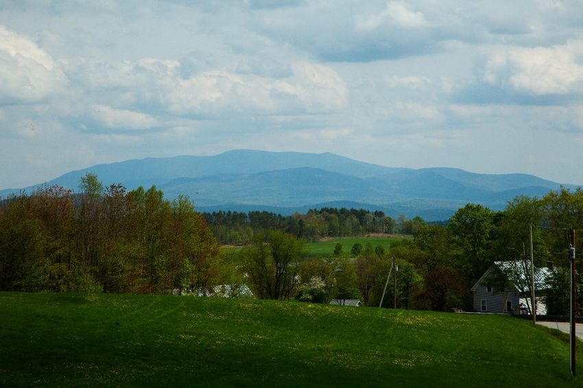
Ryegate has a number of scenic viewsheds in North Ryegate, Long Meadow Inn, an old
that should be considered rare and stagecoach stop on what is now Route 5 in
irreplaceable treasures. Route 5 is part of the East Ryegate, as well as the East Ryegate
bi-state Connecticut River Byway, which is church, and our two active churches, South
a federal designation to raise awareness of Ryegate Presbyterian Church, and the
the unique historic, cultural, and highly Ryegate Corner Presbyterian Church. There
scenic resources the region has to offer. The are eight historic districts: North Ryegate,
historic Bayley-Hazen Military Road Mosquitoville, Wormwood, East Ryegate,
intersects with Route 5, passing Ticklenaked South Ryegate, Ryegate Corner, Symes
Pond and Ryegate Corner, and extending to Pond, and Bible Hill.
the Barnet town line. Over time, property owners have maintained
Development along these scenic corridors or renovated structures, sometimes with
should be carefully sited and screened as public grant money. For example, South
feasible to protect the rural character of Ryegate’s Row Houses have been
these routes. Ryegate’s zoning bylaws completely renovated, and original lighting
should be reviewed to ensure that existing has been restored on the Church Street
setback requirements do not prevent careful bridge.
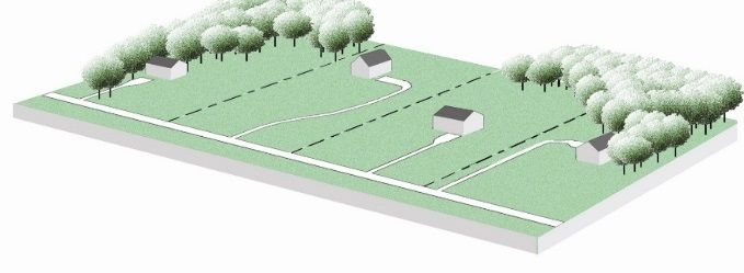
site planning. (See Figure 2.1.) The Historical Society, and the Cemetery
Figure 2.1: The illustration on the left shows how a viewshed can be altered by poor siting planning. Large
setbacks place each structure into the middle of a field. By contrast, the illustration on the right shows how
reducing setback and allowing for shared driveways can lead to better site design.
Draft 2018 Plan Page 16Commission have made particular efforts in the only sources of information about the
this area. The Historical Society uses the old thousands of years of human history before
East Ryegate Church (Whitelaw Hall) for European contact. Historic and
meetings, lectures, and storage. archaeological resources are educational and
recreational assets to communities and
As the size and complexity of their
certain sites can be important attractions to
collection grows, the Historical Society
locals and potentially even to tourists. The
seeks to secure the Whitelaw Hall in East
Vermont Division of Historic Preservation
Ryegate. This would include, at the very
hopes that sites will be preserved and
least, fireproofing and potentially archiving,
protected whenever possible to ensure these
displaying, and cataloging the collection.
vital cultural resources will be available to
This would be a good volunteer effort for
enjoy, appreciate, and study in the future.
local students. The pictures and artifacts
Any questions about particular
should be in a computer data base for ease
archaeological sites can be directed to the
of access by the public and by researchers.
Division for Historic Preservation’s State
The town records should also be considered Archaeologist.
an historic asset. Some were lost in a fire,
but the remainder are kept in a vault and are
gradually being microfilmed for safe
keeping.
ARCHAEOLOGICAL RESOURCES
Historic archaeological sites related to early
settlement, agriculture, industry and tourism
are also likely located within Ryegate’s
borders.
Cumulatively and individually, these sites
and archaeologically sensitive areas
constitute tangible links to the rich cultural,
religious, social, economic and
technological traditions of past generations
of Vermonters. These resources can help us
understand little known chapters of
Vermont’s history. Precontact
archaeological sites, in particular, are often
Draft 2018 Plan Page 173. TRANSPORTATION
GOALS:
• Support a multi-modal
transportation system that is safe,
convenient, economic, and energy
efficient.
• Reduce reliance on single
occupancy vehicles as is feasible
for a rural community.
• Protect the integrity of Ryegate’s
scenic roads.
POLICIES:
• The Town of Ryegate will encourage and explore a full range of appropriately-scaled
alternatives to single occupancy vehicles, such as ride sharing, bicycle and pedestrian
routes, and public transit.
• There should be no paving of gravel roads, and there should be an effort to preserve the
trees lining our roads.
• The speed limit should be enforced.
• Residential, industrial, and commercial development that would impact Ryegate’s scenic
vistas should be discouraged.
TRANSPORTATION STRATEGIES
• Map scenic road segments.
• Implement an access permit system for curb cuts to minimize erosion and runoffs.
• Promote “complete streets” concepts where feasible, such as portions of Route 5.
• Establish alternative fueling sites.
• Pursue Village Center Designation in order to pursue master planning funds to establish
for integrated multi-modal connections and alternative fuel charging stations.
HIGHWAYS AND STREETS The major transit routes in Ryegate are US
Route 5 and Vermont Route 302, with East
As a rural community Ryegate is quite Road running from US 5 to Ryegate Corner,
dependent on its highways and roads. and portions of the Bayley-Hazen Road
Hence, it is important that the roads be running from the Barnet Town line to
maintained for safe and efficient travel Boltonville Road to VT 302.
throughout the year.
Total mileage of Town roads is 64.36 miles.
Draft 2018 Plan Page 18Of this total, 13.96 miles are class 2 roads, Hampshire. Amtrak train service leaves
43.46 miles are class 3 roads, and 6.95 miles from White River Junction for points south.
are class 4 roads. Freight is moved by rail along the spur that
parallels the Connecticut River from
As there is no reason at this time to increase
Newport to White River Junction. Rural
the number of roads; drivers should respect
Community Transportation (RCT) provides
speed limits on our roads to make them safer
transportation for Ryegate residents to all
for all who use them. At this time, there are
types of activities throughout the year.
no plans for any additional paving of town
Stagecoach provides bus service from Wells
roads that are currently gravel.
River to Hanover and Dartmouth-Hitchcock
Maintenance priorities include: Medical Center. The RCT website posts
• Replacing Creamery Road Bridge: A current routes and services.
cost estimate was developed for this Additional road-based shuttle or
through-girder bridge back in 2014, and transportation service north to St. Johnsbury,
the minimum cost was $760,000. west to Barre/Montpelier, east to Littleton
• Re-paving the streets in both East and south to Lebanon, NH would be
Ryegate and South Ryegate villages desirable. There is interest in passenger train
service south from the Wells River station to
PARKING FACILITIES White River Junction. Preferable
transportation systems would use alternative
The Town owns three parking facilities in fuel, be scheduled to maximize use, and be
Ryegate: Town Office lot, Ticklenaked Pond subsidized for affordability.
lot, and the Town Hall lot. There are several
other private and public lots in town. BICYCLE ROUTES AND TRAILS
At this time, there is a need for additional Bicycle travel is becoming more popular as
public parking in Ryegate. We encourage we see more bike tours enjoying our scenic
the establishment of an official park and ride byways each year. The Cross Vermont Trail
on or near Route 302, in East Ryegate offers a bike and walking path from Blue
village, and other developed centers that Mountain School, past Boltonville, and on to
would help residents and commuters reduce Groton State Forest. The bulk of this trail is
their reliance on single-occupancy vehicles. on the old railroad bed and traverses the
Obtaining Village Center Designation for southern portion of Town. Town roads are
Ryegate’s three villages may help the town generally well suited to bicycling and
access funds to establish public park and walking after spring mud season through to
rides. (For more information about reducing the fall.
our reliance on single-occupancy vehicles
The existing extensive network of roads and
and fossil fuels, read Ryegate’s Energy Plan
on page 40, as well as Appendix C: Benefits trails could be better used with better
of Village Center Designation.) education/publicity, better maps and an
increased emphasis on safety (speed limit
MASS TRANSIT enforcement). While Route 302 has a wide
shoulder; Route 5 does not. Any future
There are no mass transit terminals in improvements to Route 5 should include a
Ryegate. People may take a Greyhound bus bike lane or adequate shoulder for safer
from White River Junction or Montpelier. riding.
Dartmouth Coach bus service to Boston and
Logan Airport departs from Hanover, New In 2011, Vermont’s “Complete Streets” bill
Draft 2018 Plan Page 19was signed into law. The legislation is based airports in Burlington, VT, Manchester, NH,
on a concept that state and town streets, Boston MA., Hartford, CT, and Montreal,
roads and highways should safely Quebec.
accommodate all transportation system
ROADS AND WATER QUALITY
users, regardless of age, ability, or what
mode of transportation they prefer – Research and water quality monitoring has
walking, biking, driving, or use of transit. indicated that roads are responsible for 6-
The policy applies when new roads are 10% of phosphorus loads to Lake
being constructed, and when paved roads are Champlain, and other waterways, and roads
being reconstructed, rehabilitated, or contribute over 10% of sediment loads.
otherwise maintained. Excessive sediment and phosphorus can
Typical elements that make up a complete cause algae blooms, increase water turbidity
street range from sidewalks, to bicycle lanes (cloudiness), and degrade fish and
(or wide, paved shoulders), shared-use invertebrate habitat.
paths, and transit stops. In rural areas The 2015 legislative session created a new
examples could be the striping of shoulders regulatory framework addressing all work
on paved roads to accommodate bicyclists on Town Highways, The Municipal Roads
and others or the development of a separate General Permit, as part of the Act 64- the
multi use path. While it is not possible to Vermont Clean Water Act. This general
retrofit all roads, the Town should advocate permit is intended to achieve significant
for measures that will allow for safe non- reductions in stormwater-related erosion
motorized uses where feasible. from municipal roads, both paved and
SCENIC ROADS unpaved.
Municipalities will develop and implement a
Scenic roads are everywhere in Ryegate, customized, multi-year plan to stabilize their
from the main highways to the back roads. road drainage system. The plan will include
Scenic qualities include mature trees, long- bringing road drainage systems up to basic
range views, and historical transportation maintenance standards, and additional
routes, such as the Bayley-Hazen Military corrective measure to reduce erosion. The
Road. Our most scenic roads afford long town is currently working to NVDA to
range views east to the White Mountains identify erosion-prone road segments
and west to Orange, Topsham, and Groton. connected to water bodies. This work will
Blue Mountain and Ticklenaked Pond are identify a series of stormwater
focal points for many of our scenic roads. improvements needed to meet the Municipal
Other examples include portions of the Roads General Permit Conditions.
following roads: Groton-Peacham, Hall,
BRIDGE AND CULVERT INVENTORY
Witherspoon, Scotchburn, and Stone Road.
AIRPORTS The Vermont Online Bridge and Inventory
Tool (VOBCIT) database shows that
There are no airports in Ryegate. There are Ryegate has 713 culverts, with the majority
small, rural airports for private planes in found to be in good condition.
Lyndonville, in Berlin, and across the The VOBCIT shows that there are 81
Connecticut River in North Haverhill, N.H. culverts in “poor” condition (i.e. about 25%
There is an airport in West Lebanon, NH for open with serious deficiencies.) Culverts in
commuter flights, with larger, international poor condition are found mostly around the
Draft 2018 Plan Page 20Bayley Hazen Road, Hall Road, and neither inspected nor prioritized by the state,
Creamery Road. This is due to sediment and no formal system for identifying or
load which is deposited during storm events. assessing them currently exists. In fact, short
Undersized or “plugged” culverts often structures have not been depicted on the
result in storm runoff flowing over the road Town Highways Maps since 2003. Towns
or highway, rather than under it, and are responsible for the inspection of their
damaging or even washing out the roadway. own short structures. In 2015, NVDA
The Northeastern Vermont Development performed condition assessments on town
Association (NVDA) annually assists towns short structures, classifying them as “Good,”
in updating their culvert data by hiring “Fair,” or “Poor.” The conditions
consultants to do the field work using GIS assessment will be an important tool for
and then uploading this to the VOBCIT. The identifying medium- to long-range costs for
VTrans Maintenance Districts ideally want maintaining, upgrading, and repairing short
an inventory done every three years, but structures.
NVDA can only do 4-5 towns per year.
PRESENT TRANSPORTATION MAP
NVDA is working to get towns to use
VOBCIT to input their annual updates so The present transportation and facilities map
that they will always have an up to date is on file in the Ryegate Town Clerk’s office
inventory. and can be viewed there. Transportation
“SHORT” STRUCTURES information can also be found on the Base
Map in Attachment A.
VTrans is required to inspect all bridges
with a span of 20 feet or longer, whether
they are located on a federal-aid system or a
town highway. These inspections occur once
every two years, and reports of the
inspections are sent to the Town.
The bridge and culvert inventory does not,
however, contain information on town
highway “short structures,” which are
bridges with a span of less than 20 feet but
equal to or greater than 6 feet. These are
Draft 2018 Plan Page 214. FLOOD RESILIENCE
GOALS
• Mitigate Ryegate’s flood hazards in the most cost-effective manner possible.
• Minimize the risk exposure and associated expense to Ryegate tax payers.
• Ensure the Town and its facilities are prepared to meet the demands of the next flood.
FLOOD RESILIENCE STRATEGIES:
• Identify methods for safely reinforcing the bank of unnamed tributary to Wells River in
South Ryegate.
• Continue participation in the National Flood Insurance Program and participate in
trainings for local officials and property owners when such trainings are available.
• Consider amending the zoning regulations to waive setback requirements so that property
owners can locate or relocate structures on less flood-prone areas on the lot.
• Disseminate information on strategies to reduce flood risks, such as freeboarding
(elevating structures) and waterproofing.
• Review and evaluate new stream geomorphic data when it becomes available.
• Continue dialog with the public, state and regional agencies, and land conservation
groups regarding protection of wetlands and stabilization of erosion prone areas.
• Keep the Local Emergency Operations Plan up to date.
• Update and readopt the Local Hazard Mitigation Plan.
• Research the feasibility of a shelter agreement with the Red Cross.
• Maintain VTrans Road and Bridge Standards to incorporate best practices to minimize
washouts and damage.
• Encourage efforts to provide real-time data stream reporting from Wells River, e.g. data
trackers that transmit data on flood levels via social media.
• Support NH DEC’s efforts to improve flood forecasting relative to dams.
Draft 2018 Plan Page 22You can also read