San Fernando Safe and Active Streets Implementation Plan - DRAFT December 2021 - City of San ...
←
→
Page content transcription
If your browser does not render page correctly, please read the page content below
San Fernando
Safe and Active Streets
Implementation Plan

                          DRAFT
                   December 2021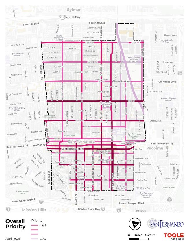
THIS PAGE IS INTENTIONALLY LEFT BLANK.

                  ii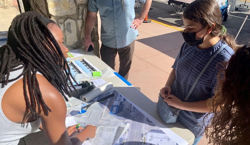
SAN FERNANDO   |   ACKNOWLEDGEMENTS

Acknowledgements
The City of San Fernando and Project Team thanks all those who helped shape and develop the San Fernando
Safe and Active Streets Implementation Plan. Acknowledgments are in alphabetical order by first name.

San Fernando City Council                                          Los Angeles County Department of Public Health
 Celeste Rodriguez, Council member                                  Alexis Lantz, Policy Analyst
 Cindy Montañez, Council member                                     Chanda Singh*
 Hector Pacheco, Vice Mayor                                         Justin Robertson, Senior Planner
 Mary Mendoza, Mayor                                                Mehmet Berker*
 Sylvia Ballin, Council member
                                                                    Advisory Committee Members
                                                                    Adriana Gomez
San Fernando Transportation                                         Anthony Vairo
& Safety Commission                                                 Audrey Simons
 Carlos Hernandez, Chair                                            Christina Bernal
 Dee Akemon, Commissioner                                           David Bernal
 Francisco Arrizon, Vice Chair                                      Flaviola Garcia
 Nicole Mohr, Commissioner                                          Freddy Ortiz
 Rudy Trujillo, Commissioner                                        Gerardo Marquez
                                                                    Lucia Alfaro

San Fernando City Manager’s Office                                  Marco Torres

 Nick Kimball, City Manager                                         Nicole Mohr

San Fernando Department of Public Works                            Tree People
 Kenneth Jones, Management Analyst                                  Cindy Villegas

 Manuel Fabian, Civil Engineering Assistant II                      Daniel Berger

 Maria Padilla, Executive Assistant
 Matthew Baumgardner, Public Works Director                        Plan Prepared By
 Patsy Orozco, Civil Engineering Assistant II                       Toole Design
                                                                    Local Government Commission

San Fernando Police Department                                      Public Health Advocates

 Anthony Vairo, Chief of Police
                                                                   Funding Agency
                                                                    This product was generously funded by the California
                                                                    Department of Transportation (Caltrans)
                                                                    *may no longer be representing the agency

                                                             iii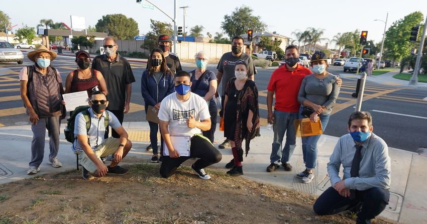
THIS PAGE IS INTENTIONALLY LEFT BLANK.

                  iv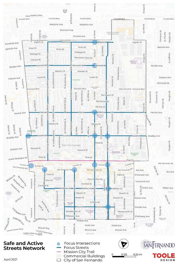
SAN FERNANDO

Contents
Acknowledgements ...................................................................................................................... iii
Executive Summary .................................................................................................................... vii
Why a Safe and Active Streets Implementation Plan? ................................................................ 3
    Implementation Plan Goals	����������������������������������������������������������������������������������������������������������������������������������������������3

What Do We Know? (Existing Conditions)............................................................................................ 6
    Street Prioritization Methodology	�����������������������������������������������������������������������������������������������������������������������������������7

    Safe and Active Streets Network	������������������������������������������������������������������������������������������������������������������������������������7

What did the Community Say? .................................................................................................... 12
    Who was Involved? 	��������������������������������������������������������������������������������������������������������������������������������������������������������� 12

    Advisory Group Meetings	����������������������������������������������������������������������������������������������������������������������������������������������� 13

    Ad Hoc Group Meetings	�������������������������������������������������������������������������������������������������������������������������������������������������� 13

    Walk Audits and Bike Audits	������������������������������������������������������������������������������������������������������������������������������������������ 14

    Pop-up Charrettes	����������������������������������������������������������������������������������������������������������������������������������������������������������� 17

    Community Engagement Key Takeaways	��������������������������������������������������������������������������������������������������������������������21

What Projects are Recommended, and Where? (Recommendations) .........................................24
    Map of Recommendations	����������������������������������������������������������������������������������������������������������������������������������������������24

    Concept Designs	��������������������������������������������������������������������������������������������������������������������������������������������������������������26

    Cost Estimates	�����������������������������������������������������������������������������������������������������������������������������������������������������������������28

    Rapid Implementation Projects	�������������������������������������������������������������������������������������������������������������������������������������28

What’s Next? ................................................................................................................................34
    Funding Sources	��������������������������������������������������������������������������������������������������������������������������������������������������������������34

    Evaluation and Monitoring	����������������������������������������������������������������������������������������������������������������������������������������������37

    Programmatic Recommendations	��������������������������������������������������������������������������������������������������������������������������������38

                                                                                         v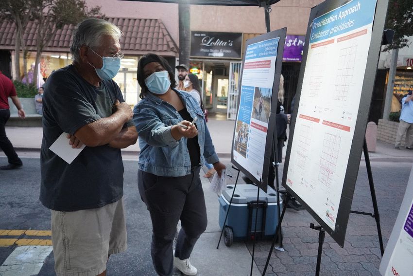
THIS PAGE IS INTENTIONALLY LEFT BLANK.

                  vi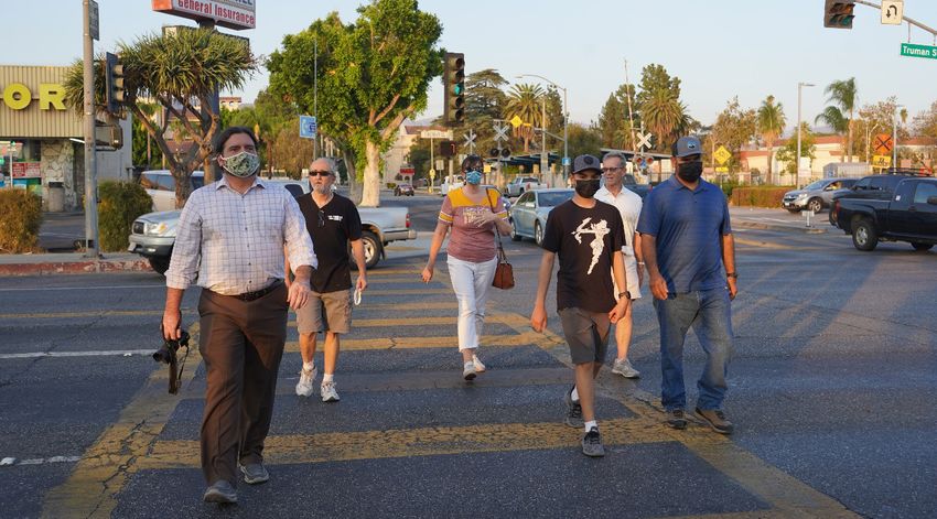
SAN FERNANDO | EXECUTIVE SUMMARY
Executive Summary
The City of San Fernando is in a prime position to continue streets and sidewalks for walking and biking creates a key
building on the council adopted 2017 Safe and Active opportunity for this Safe and Active Streets Implementation
Streets Plan and has the right foundation to encourage Plan (Implementation Plan). The pandemic also presented
walking and biking. The city is primarily made of small challenges for this project, specifically in how to keep the
neighborhood streets on a well-connected grid with community engaged through a variety of online and in-
no freeway on/off ramps, which is unique in Southern person methods. Through virtual meetings with an establish
California. San Fernando is also home to many small advisory group, socially-distant walk audits, pop-up
businesses, schools, parks, and civic destinations that community charrettes at the San Fernando mall, and other
make it an ideal walking environment. The only major efforts, the project team used a multi-pronged approach to
identifiable connectivity barrier today is the railroad, which create awareness and excitement for this Plan.
offers great opportunities with the forthcoming East San
The results of the Implementation Plan will help prioritize
Fernando Valley Transit corridor and existing Metrolink
and make recommendations to improve safety and physical
station, particularly for commuters traveling to Downtown
activity at key locations in San Fernando. These projects are
Los Angeles. Small, well-connected streets, a growing local
also developed to help secure grant funding for construction
business culture, and future transit infrastructure helps
and implementation. Additionally, the Implementation Plan
form the backbone of a low-stress pedestrian and bicycle
serves as a method to keep the San Fernando community
network throughout San Fernando.
engaged on proactive street safety efforts and build
As the COVID-19 pandemic has impacted daily life for many stewardship and support for many years
residents, the need to access safe locations for physical to come.
activity are more important than ever, and improving
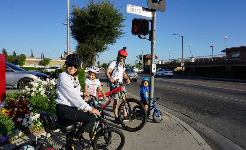
Family on a Bike Ride near Brand Boulevard and Truman Street
vii
THIS PAGE IS INTENTIONALLY LEFT BLANK.

                 viii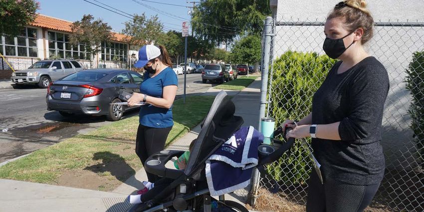
Chapter 1:
Why a Safe and Active Streets
Implementation Plan?
THIS PAGE IS INTENTIONALLY LEFT BLANK.

                  2
SAN FERNANDO | WHY A SAFE AND ACTIVE STREETS IMPLEMENTATION PLAN?
Why a Safe and Active Streets
Implementation Plan?
This plan builds on the Safe and Active Streets Plan
published in 2017, which included an Active Transportation Implementation
Plan and a Safe Routes to School Plan for the 11 schools
in the city. The intention of the 2017 plan was to guide the
Plan Goals
City in improving streets and implementing programs that • Build on the 2017 Safe and Active Streets Plan
make it safer and more comfortable to walk and bicycle. • Engage community members to identify priorities
The Implementation Plan expands on the recommendations • Prioritize transportation projects
in the 2017 plan and provides the next steps for the City to
begin implementation. The Implementation Plan identifies • Develop conceptual plans and cost estimates
priority projects to make streets safer and more active, • Identify short-term and long-term projects
and that can be implemented in the short term through This Implementation Plan was developed in tandem with
maintenance projects, capital improvements projects, and community stakeholders, City councilmembers, City staff,
through receiving state and local grants. the consultant team, and resident input.
Community Members Participating in a Walk Audit
3THIS PAGE IS INTENTIONALLY LEFT BLANK.
4Chapter 2: What do we know? (Existing Conditions)
SAN FERNANDO        |   WHAT DO WE KNOW? (EXISTING CONDITIONS)

What Do We Know? (Existing Conditions)
The 2017 Safe and Active Streets Plan includes many general recommendations for improving safety and physical activity
through infrastructure and programmatic recommendations. The 2017 plan also includes a chapter on street segment
prioritization and recommended projects based on a set of criteria including the ability to meet project goals, ease of
implementation, and community support and priorities. The following list outlines the streets/segments that were identified
as priorities under the 2017 plan.

Arroyo St                                    Harding Ave                             S Lazard St

Brand Blvd                                   Hollister St                            San Fernando Mission Blvd

Carlisle St                                  Hubbard Ave                             San Fernando Rd

Celis St                                     Kalisher St                             Seventh St

East Canyon Channel                          Maclay Ave                              Seventh Street Bridge
                                                                                     over Pacoima Wash
Eighth St                                    Mission City Trail
                                                                                     Third St
Fifth St                                     Morningside Ct
                                                                                     Truman St
First St                                     Mott St
                                                                                     Wolfskill St / Jessie St
Fourth St                                    Orange Grove Ave
                                                                                     Workman St / Rinaldi St
Fox St                                       Pacoima Wash Greenway
                                             (Eastbank)
Glenoaks Blvd
                                             Pacoima Wash Greenway (Westbank),
Griswold Ave                                 Eighth St Bridge

 Previous Crosswalk Improvements along Workman Street

                                                                  6
SAN FERNANDO | WHAT DO WE KNOW? (EXISTING CONDITIONS)
Street Prioritization Fernando streets located within census tracts with a higher
environmental and socioeconomic burden are shown as
Methodology higher priority for project investigation and development.
Considering the 2017 Plan list is comprehensive and the City The output of the three combined prioritization factors is
of San Fernando may be resource-constrained to improve illustrated in the Prioritization Network Output map, Figure 1.
safety and active transportation for all roadway segments, Streets that are shown as highest priority for encouraging
the Implementation Plan applies similar prioritization active transportation include Fifth Street, Fourth Street, San
criteria using recent datasets and a thorough understanding Fernando Road, Hollister Street, Workman Street, Kalisher
of recent City transportation trends. Street, Maclay Street, and Brand Boulevard.
The prioritization criteria applied to the 2017 street
segments include the following:
Safety – Using the latest five years of pedestrian
Safe and Active
collision data, we assessed the number of
collisions along each street segment and
Streets Network
The prioritization framework was used to develop the
weighted collisions by severity, assigning
Safe and Active Streets Network- a network of streets
collisions resulting in fatalities or severely injuries a
suitable for further investigation through the project’s
numeric value of 3, and all other injuries (minor injury,
many engagement efforts (see Figure 2). These streets
complaint of pain) a numeric value of 1. The crash data used
are labeled as focus streets. The focus intersections were
for this analysis was from the California Highway Patrol’s
also included based off concentrations of collision patterns
(CHP) Statewide Integrated Traffic Records System
with pedestrians. This network was also used to establish
(SWITRS), accessed via the Transportation Injury Mapping
walking and biking audit routes for the project team to
System (TIMS)1. Some of the streets with the highest fatal
better understand suitable project types throughout San
and severe injuries include San Fernando Road and Truman
Fernando.
Street.
Connectivity – creating access and connections
to destinations like parks, schools, libraries, and
shopping centers, can improve the number of
walking trips and overall physical activity. A
street connecting to such destinations indicates a higher
priority compared to the rest of San Fernando’s streets.
Equity – It is important to invest in areas of the
City that have more environmental and
socioeconomic burdens when compared to the
rest of San Fernando or to Los Angeles County
as a whole. Our team applied the California Communities
Environmental Screening Tool (CalEnviroScreen 3.0)
developed by the California Office of Environmental Health
Hazard Assessment, to assess environmental burden at the
census tract level for San Fernando. The factors associated
with the CalEnviroScreen 3.0 index includes environmental
indices like pollution exposure, traffic exposure, residents
with asthma and cardiovascular disease, and
socioeconomic indices like poverty, unemployment,
educational attainment, and linguistic isolation. San
Trolley Stop near the San Fernando Swap Meet
1 Tims.berkeley.edu
7SAN FERNANDO | WHAT DO WE KNOW? (EXISTING CONDITIONS)
Figure 1: Prioritization Network Output
8SAN FERNANDO | WHAT DO WE KNOW? (EXISTING CONDITIONS)
Figure 2: Safe and Active Streets Network
9THIS PAGE IS INTENTIONALLY LEFT BLANK.
10Chapter 3: What Did the Community Say?
SAN FERNANDO   |   WHAT DID THE COMMUNITY SAY?

What did the Community Say?
A variety of outreach and engagement strategies were used
to minimize barriers to participation and obtain the broadest
possible community input. The global COVID-19 pandemic’s
impact on many people’s lives, resources, and ability to
stay safe and healthy brought challenges to traditional
engagement approaches and to participation. Nevertheless,
engagement for this Implementation Plan utilized close

                                                                       Who was Involved?
relationships with the local community, formed in part
during the previous Safe and Active Streets Plan, to ensure
robust participation in both a virtual and in-person, socially-        The public and stakeholder engagement process invited
distant format. Engagement activities as part of this                  residents from diverse communities and backgrounds
Implementation Plan are outlined below and described in                to participate in the Plan’s development and to remain
more detail under the Who was Involved? section:                       informed as the Plan progressed. Residents, business
                                                                       owners, bicycle interest groups, and city commissioners
• Advisory Committee Meetings (3)
                                                                       participated in engagement events, such as the walk and
• Ad Hoc Committee Meetings (2)                                        bike audits. City representatives and key stakeholders
• Walk Audits (6)                                                      were invited to be part of the Safe and Active Street
                                                                       Implementation Plan Advisory Group, which played a
• Bike Audits (2)
                                                                       pivotal role in the Plan’s community engagement process
• Pop-up Charrettes (2)                                                and progression. Overall, the public and stakeholder
• Regular updates to the Transportation and Safety                     engagement efforts saw a robust turnout from San
  Commission                                                           Fernando’s community members, ensuring that the Plan
                                                                       reflects the community’s priorities and preferences.
• Draft Plan review meeting

 Group Photo of Walk Audit Participants

                                                                  12
SAN FERNANDO | WHAT DID THE COMMUNITY SAY?
Advisory Group Meetings Ad Hoc Group Meetings
The Advisory Group was made up of representatives from The Ad Hoc group was made of city staff and council
a variety of City representatives and stakeholders. The goal members Cindy Montañez and Celeste Rodriguez. They
of the Advisory Group was to provide local knowledge of provided additional support for the development of the
the study area, gather feedback for direction of the plan, plan and assuring this project was coordinated with other
and to help ensure robust community participation in the ongoing efforts.
development of the Plan. The committee met three times
• Ad Hoc Group Meeting 1 (March 2021): The first meeting
over the course of the project.
covered the initial prioritization methodology and factors
• Advisory Group Meeting 1 (February 2021): The Project for assessing city streets that could be prime for active
team introduced the project and shared information on the transportation improvements.
scope and timeline, as well as upcoming public engagement • Ad Hoc Group Meeting 2 (April 2021): The second
opportunities. Advisory Group members discussed issues meeting focused on feedback for the Safe and Active
and challenges for walking and biking in the study area Streets network and brainstorming on outreach for the
using an interactive poll called Mentimeter to ask members summer walk and bike audits.
about general priorities and issues (see Figure 4).
• Ad Hoc Group Meeting 3 (July 2021): The third meeting
• Advisory Group Meeting 2 (May 2021): The second focused on other issues that the Implementation Plan
Advisory Group and the Project team reviewed community should consider, such as lighting, illegal dumping, and
engagement and planning efforts in preparation for the brainstorming on how a proposed street improvement
community pop-up charrette. The Advisory Group and project can incorporate other elements such as
the project team also discussed preliminary locations beautification and green infrastructure.
for prioritization and project features most applicable to
challenges facing residents on streets and sidewalks.
• Advisory Group Meeting 3 (August 2021): The last
Advisory Group meeting included reviewing concept
plans and recommendations after considering community
feedback at the end of the public engagement period. The
meeting was also used to discuss and review the draft
outline for the Implementation Plan.
13SAN FERNANDO | WHAT DID THE COMMUNITY SAY?
Figure 4: Mentimeter Poll Sample
Walk Audits and Bike Audits
A walk or bike audit is a short group walk or bike ride on a and biking in what was likely the most congested times of
predetermined route to observe and make note of safety day. In response to the COVID-19 pandemic and to ensure
concerns and other issues that create barriers to walking, appropriate physical distancing, each audit was limited to
biking, rolling, and other forms of active transportation. a maximum of 14 participants. Around 50 unique people in
The project team developed six walk audit routes and two total participated in the eight audits (some participating in
bike audit routes. Audits took place during morning and more than one). Figure 3 shows a map of the walk and bike
evening commute times to capture peak travel periods audit routes.
as well as observe behavior for people driving, walking,
Walk Audit Participants
14SAN FERNANDO | WHAT DID THE COMMUNITY SAY?
Figure 3: Walk and Bike Audit Routes
15SAN FERNANDO | WHAT DID THE COMMUNITY SAY?
Walk and Bike Audits,
Key Takeaways
The walk and bike audits provided the project team with on-
the-ground data collection and critical community feedback
to inform project prioritization and recommendations.
Walk audit participants noted infrastructure and behavioral
issues along each of the six routes, and the top three most
commonly observed issues observed for each route are
included in Table 1 below. Across all routes, participants
noted a need to upgrade/improve crosswalks. Other
common issues included missing curb ramps, general
maintenance needs, and speeding. Participants also noted
opportunities for creating a more welcoming pedestrian
environment through landscaping, such as planting shade
trees to mitigate hot conditions during summer months.
Walk Audit Participant Noting Observations
Table 1: Infrastructure Issues Observed during Walk Audits
Bike audit participants included a mix of recreational
riders who are comfortable riding with traffic, and casual
Route Top 3 Issues Observed or less-confident bicyclists who do not typically bike on
San Fernando streets. On Route G (Fourth St / Mission City
Route A: Crosswalk improvements needed Trail) participants noted that drivers do not always stop
Eighth St and Missing curb ramps / maintenance
for bicyclists and that there was a potential to add bike
S Brand Blvd Landscape / parkways
crossing improvements like signals or flashing beacons
Route B: at certain intersections. Participants on bike audit Route
Pioneer Park
General maintenance needed H (southbound on Brand Blvd) found that there were
(Glenoaks Blvd,
Speeding opportunities for adding bike facilities, like separated bike
N Brand Blvd,
Crosswalk improvements needed lanes, near San Fernando Middle School, as well as along
Fifth St, and
Harding Ave) the length of Brand Blvd. to connect with bike lanes in the
Route C: City of Los Angeles.
Hubbard St,
General maintenance needed
First St,
Sidewalk in need of repair
Truman St,
Crosswalk improvements needed
S Lazard St, and
San Fernando Rd
Route D:
Maclay Ave, Crosswalk improvements needed
Coronel St, and General maintenance needed
San Fernando Landscaping/parkways
Mission Rd
Route E:
Fourth St, Crosswalk improvements needed
Park Ave, San Sidewalk in need of repair
Fernando Rd, and Speeding
N Brand Blvd
Route F:
Crosswalk improvements needed
Hollister St,
Missing curb ramps / maintenance
S Brand Blvd,
needed
Mott St, and
General maintenance needed
S Kalisher St Bike Audit Participants Biking Down Maclay Ave
16SAN FERNANDO | WHAT DID THE COMMUNITY SAY?
Pop-up Charrettes
Pop-up Charrette #1, June 26th, 2021
San Fernando Safe and Active Streets team held its The purpose of the first pop-up was for community
first Charrette on June 26th, 2021 from 12pm-6pm. The members to learn about the project, and provide feedback
project team set up in front of Throwback Junction at the on the initial safe and active streets network. The Safe
San Fernando Mall as part of the monthly open street and Active Streets Pop-up booth had concept boards that
event hosted by the San Fernando Mall Association. In presented the Walk & Bike Audit results, a data analysis and
preparation for this event, Public Health Advocates took street prioritization approach board, a street improvement
lead on outreach activities that included contacting the San board with a dot sticker exercise for determining preferred
Fernando Advisory Group; local residents (some of whom countermeasures (project types), and guidance on next
had previously participated in the Walk & Bike audits), steps. The project team also facilitated a concept plan
San Fernando Business Watch Group, and producing and and streetmix section exercise that allowed residents to
distributing event flyers in person (Recreation Park and visualize how new designs can be implemented, and held
Las Palmas Park) and through City of San Fernando as discussions about trade-offs on city streets. In addition
well as Public Health Advocates’ social media outlets. to the concept boards, Public Health Advocates provided
Media outreach was accomplished by producing a local comment cards for residents to provide feedback, a total
radio broadcast through Ollin Radio station; this broadcast of 19 residents provided feedback. The Pop-Up event saw
was provided by Council member Cindy Montanez a combined participation of approximately 100 San Fernando
week prior to the event. All broadcasts promoted the San residents. One consideration was made to host the next
Fernando Charrette as a “pop-up” rather than a traditional, pop-up opportunity during the evening hours as the first
indoor type of charrette to ensure the public could easily pop-up event occurred at noon during the peak summer
participate. heat, impacting participation from the broader public.
Stakeholders and Staff Go over Geometric Designs at the First Pop-up Charrette
17SAN FERNANDO | WHAT DID THE COMMUNITY SAY?
Pop-up Charrette #2, September 25th, 2021
San Fernando Safe and Active Streets team held its second Once again, Public Health Advocates provided comment
Charrette on September 25th, 2021 from 5pm-9pm in front cards for residents and encouraged participants to provide
of Throwback Junction at the San Fernando Mall during feedback on the concept boards using post-it notes. A total
another open street market event. Outreach for the second of 72 comment cards were collected for this event. It is
charrette encompassed all of the same activities from important to note that 100 cards were originally brought to
the first charrette. Media outreach was accomplished by the event and distributed, yet many comment cards were
producing two local radio broadcasts through Radio Ollin not returned. Considering this, our team estimates that
and San Fernando Voz del Valle radio stations. Like the over 100 San Fernando residents were able to review the
first charrette, the San Fernando Safe and Active Streets Safe and Active Streets project, draft concept plans, and
team chose to promote the event as a “Pop-Up” for public understand the intention of the project, even if not everyone
accessibility purposes. commented.
The purpose of the second Pop-Up was for community Draft Concept Design Locations
members to review the draft design plans developed based
on resident feedback from both the walk and bike audits and • Jessie Street and Robert F Kennedy Drive
the first pop-up on June 26th. The Safe and Active Streets • Harding Avenue and Fourth Street
pop-up booth had concept boards presenting preferred
• Kalisher Street and Hewitt Street
countermeasures (project types) identified by San Fernando
residents and how they apply to the chosen key areas of • San Fernando Road and Kittridge Street/Chatsworth
improvement. Participants were able to walk through the Street
pop-up booth and review draft concept designs for resident • San Fernando Road and Lazard Street
feedback (see Figure 5). Residents were also given the • San Fernando Road and Huntington Street
opportunity to join the Safe and Active Streets team on a
site visit (design walk) that took place from 5:30pm-6:30pm. See Chatper 4 - Recommendations, for a breakdown of the
concept location selection process.
Design Walk Participants
18SAN FERNANDO | WHAT DID THE COMMUNITY SAY?
Pop-up Event Participants
19SAN FERNANDO | WHAT DID THE COMMUNITY SAY?
Figure 5: Concept Plan Board for Two Locations
20SAN FERNANDO | WHAT DID THE COMMUNITY SAY?
Community Engagement Key Takeaways
The community engagement and public participation Meanwhile, the community pop-up charrette events
process provided the project team with invaluable feedback provided the team with location-specific feedback to the
for project locations, design features, and it provided the safe and active streets network, as well as the proposed
project team the opportunity to communicate the Plan’s concept plans.
vision and goals to community members.
There is overwhelming community support for developing
The walk and bike audits provided an opportunity for projects in San Fernando that may increase the safety and
the community and project team to examine existing physical activity. While many residents expressed that they
conditions and gain insights from residents who are aware already regularly walk or bike, they also noted that specific
of potential improvements through their lived experience- improvements along busy streets will help create better
walking, biking, taking transit, and using wheeled devices connections to important destinations.
(wheelchairs, strollers, scooters) on San Fernando Streets.
Pop-up Event Participants
21THIS PAGE IS INTENTIONALLY LEFT BLANK.
22Chapter 4: What Projects are Recommended, and Where? (Recommendations)
SAN FERNANDO      |   WHAT PROJECTS ARE RECOMMENDED, AND WHERE? (RECOMMENDATIONS)

What Projects are Recommended,
and Where? (Recommendations)
The analysis of the 2017 Safe and Active Streets Plan and
multi-pronged engagement efforts for this plan resulted             Concept Designs
in recommendations that focus on improving safety and               The concept design plans (Figure 7 through Figure 14),
increasing physical activity. One of the intentions of the          referenced in the Selected Concept Design Projects Map,
Implementation Plan was to identify the lowest cost,                describe the design features associated with each location.
highest impact approach to improving safety, considering            Although there were many locations with high opportunity
both design and constraints on implementation. The Plan             for improvements, the locations with concept designs
identifies a comprehensive strategy for implementing                focus on geometric changes to the roadway that require
targeted safety countermeasures, including location-                conceptual vetting. Examples include ensuring that a
specific and sample concept designs that can be applied to          delivery vehicle can make a proper right turn where a curb
many residential and collector streets in San Fernando.             extension is proposed. Concept design plans are typcially
                                                                    also included as part of grant applications for funding
The Plan recommends a phased approach so that                       agencies to better understand the physical improvements or
enhancements can be deployed quickly, with available                changes made to the roadway.
funding, tested and evaluated, and modified as required
before more permanent and capital-intensive measures
are designed and constructed. The phasing strategy and
funding sources are described in more detail in the Next
Steps section of this report.

Map of
Recommendations
The following projects outlined in Figure 6 are
recommended for implementation and have been vetted
by the community through the aforementioned robust
engagement process. These projects vary in cost and
complexity, yet all projects are feasible in concept and can
be advanced to final engineering design in accordance with
the State, county, and City standards. Moreover, they may
be used as part of grant applications to secure funding for
implementation.

                                                               24
SAN FERNANDO | WHAT PROJECTS ARE RECOMMENDED, AND WHERE? (RECOMMENDATIONS)
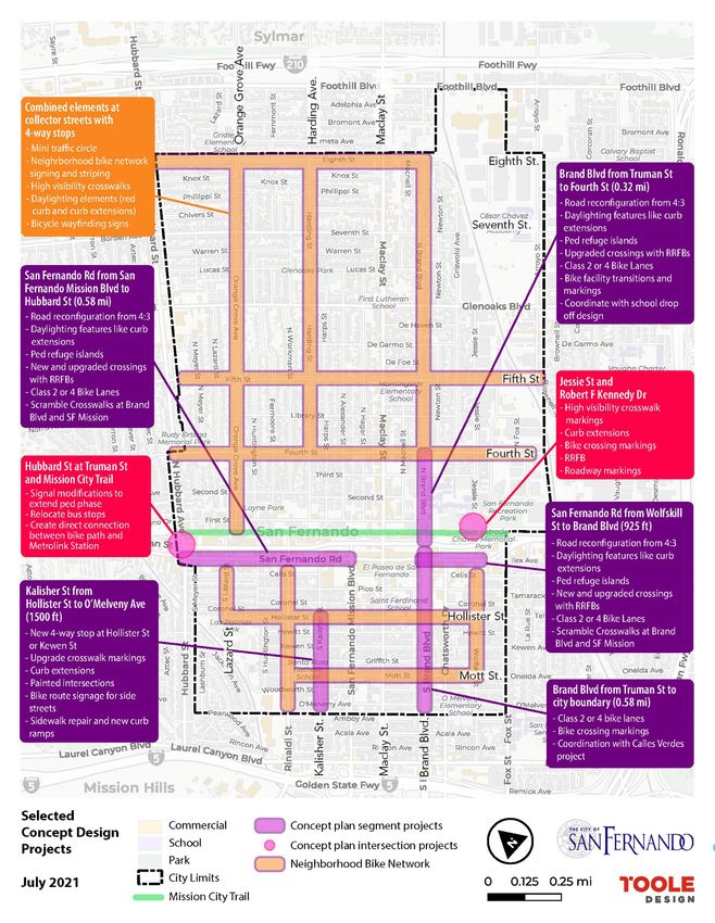
Figure 6: Selected Concept Design Projects Map
25SAN FERNANDO | WHAT PROJECTS ARE RECOMMENDED, AND WHERE? (RECOMMENDATIONS)
3
1 1 2
4 5
3
2
5
2
3
1 1
Figure 7: Jessie Street at Robert F. Kennedy Drive
26SAN FERNANDO | WHAT PROJECTS ARE RECOMMENDED, AND WHERE? (RECOMMENDATIONS)
Jessie Street at Robert F. Kennedy Drive
This location was flagged as a priority during a walk audit due to its proximity to San Fernando Middle School, San Fernando
Recreation Park, the Cesar E. Chavez memorial, senior residential housing, and the Mission City Trail (multi-use path). The
proximity to the rail tracks and the signalized intersection at Jessie Street and Truman Street creates barriers in this key
area and encourages speeding in the southbound direction. Creating improvements and connections for pedestrians and
bicyclists to destinations in this area is a priority for this plan.
Recommenda�ons:
1
Rectangular Rapid Flashing Beacons (RRFBs) improve
visibility for people crossing the street.
2 Concrete and painted curb extensions reduce crossing dis-
tances and provide space for trees and landscaping.
3 Con�nental crosswalks improve visibility for people crossing
the street.
A bike box increases visibility for people riding bikes and
4
minimizes conflicts between drivers and bicyclists.
A buffered bike lane is more comfortable for less confident
5 riders and provides addi�onal distance between people
biking and people driving.
27SAN FERNANDO | WHAT PROJECTS ARE RECOMMENDED, AND WHERE? (RECOMMENDATIONS)
1
1
1
1 2
ST
Figure 8: Hubbard Avenue at Truman Street
28SAN FERNANDO | WHAT PROJECTS ARE RECOMMENDED, AND WHERE? (RECOMMENDATIONS)
Hubbard Avenue at Truman Street
This intersection is one of the busiest in San Fernando and borders the City of Los Angeles; creating key regional transit
connections through Metro local bus lines, Metro Rapid bus lines, the newly established LADOT DASH circulator bus route,
the Sylmar / San Fernando Metrolink station, and the Mission City trail that connects to the neighborhood of Sylmar. The
City of San Fernando has experienced 14 fatal and severe pedestrian and bicycle involved collisions from 2015 – 2019, three
of which have occurred at this intersection2. Walk audit participants also noted the existing difficulties at this intersection,
especially observing commuters cross Hubbard Street to access the Metrolink Station. Recommendations at this intersection
include rapid implementation projects, as well as additional coordination with Metro for bus stop relocations.
Recommenda�ons:
1 Con�nental crosswalks improve visibility for people
crossing the street.
2 Reloca�ng the bus stop reduces conflicts between
buses, transit riders, and vehicles at the car wash
driveway located at the corner of the intersec�on.
2 Statewide Integrated Traffic Records System (via TIMS query), 2015-2019
29SAN FERNANDO | WHAT PROJECTS ARE RECOMMENDED, AND WHERE? (RECOMMENDATIONS)
1
1
3
4 4
1 1
3 2 3
1 1
4 4
3
1
1
Figure 9: Typical Bicycle Boulevard Design Treatments
30SAN FERNANDO | WHAT PROJECTS ARE RECOMMENDED, AND WHERE? (RECOMMENDATIONS)
Typical Bike Boulevard Design (example at Harding Avenue at Fourth
Street)
The project team developed standard design plans for implementing a Class III Bicycle Boulevard network along well-
connected residential streets. Feedback from the advisory group and community pop-ups suggested that residents enjoy
walking and bicycling along residential streets like Orange Grove Avenue and Harding Avenue. The bicycle boulevard
treatments complement existing calm streets that may already have speed bumps and intersections with all-way stop signs.
The design treatments can be applied at other all-way stop controlled intersections throughout San Fernando to establish
Recommenda�ons:
A neighborhood bicycle network creates
1 connec�ons for bicyclists throughout San Fernando.
2 Mini traffic circles help control speeding at residen�al
intersec�ons.
3
Con�nental crosswalks improve visibility for people
crossing the street.
4 Painted curb extensions reduce crossing distances
and provide space for public art.
low stress walking and biking routes for the community.
31SAN FERNANDO | WHAT PROJECTS ARE RECOMMENDED, AND WHERE? (RECOMMENDATIONS)
3
2 2
3 1 3
2 2
3
Figure 10: Kalisher Street Improvements
32SAN FERNANDO | WHAT PROJECTS ARE RECOMMENDED, AND WHERE? (RECOMMENDATIONS)
Kalisher Street
The southwest area of San Fernando scored very high under the equity index as part of the prioritization methodology, and
community members indicated that this area should be prioritized for overall improvements. Although there are several
streets and intersections identified for improving walking and bicycling, Kalisher Street stands out as a key corridor with
several existing challenges, including: the lack of consistent all-way stop-controlled intersections, speeding drivers that
use Kalisher Street as opposed to Workman Street, multiple churches, schools, small businesses, and residences, among
others. Moreover, this street has the potential to introduce artistic elements that celebrate the history of this working-class
neighborhood through intersection murals and other traffic calming efforts.
Recommenda�ons:
4-way stop control and an intersec�on mural calms
1 traffic and improves safety for people crossing the
street.
2 Painted curb extensions reduce crossing distances
and provide space for public art.
Con�nental crosswalks improve visibility for people
3
crossing the street.
33REVISION BY APVD
SAN FERNANDO | WHAT PROJECTS ARE RECOMMENDED, AND WHERE? (RECOMMENDATIONS)
3
1
4
1
3
4
1 1
3
2 2
Figure 11: San Fernando Road from San Fernando Mission Boulevard to Hubbard Street
34SAN FERNANDO | WHAT PROJECTS ARE RECOMMENDED, AND WHERE? (RECOMMENDATIONS)
San Fernando Road from San Fernando Mission Boulevard to
Hubbard Street
As a key Northwest entrance to the City from the neighborhood of Sylmar, this segment of San Fernando Road has the
potential to create regional connections and improve conditions for all modes. As a parallel street to Truman Street, San
Fernando Road has a similar mix of commercial land use types including automobile repair shops, restaurants, and medical
services. There are also empty lots and potential plans for redevelopment in this area which can lead to increased walking
and biking trips just west of the San Fernando Mall. A road reconfiguration is recommended to provide room for bike lanes,
improved pedestrian facilities, and a two-way center turn lane. Recent Average Daily Traffic (ADT) studies and our observed
0 20' 40' 60'
walk audit during the PM peak period show that San Fernando Road does not carry as much traffic as Truman Street, and
can be a prime candidate for a road reconfiguration given the approximately 8,800 vehicles per day (ADT).3 This threshold
SCALE IN FEET PRELIMINARY
is less than the recognized criteria by FHWA which states that four-lane to three-lane road conversions for less than 10,000
- NOT
ADT are great candidates that most likely do not affect capacity.4
E 701
5
Recommenda�ons:
Rectangular Rapid Flashing Beacons (RRFBs)
1
improve visibility for people crossing the street.
2
Concrete curb extensions reduce crossing distances
and provide space for trees and landscaping.
3 Con�nental crosswalks improve visibility for people
crossing the street.
A buffered bike lane is more comfortable with less
4 confident riders and provides addi�onal distance
between people biking and people driving.
3 City of San Fernando Transportation and Safety Commission Meeting, November 3, 2021, page 59: https://ci.san-fernando.ca.us/wp-content/up-
loads/2021/11/TSC-Agenda-Packet-11-3-21.pdf
4 https://safety.fhwa.dot.gov/road_diets/resources/pdf/fhwasa17021.pdf
5 https://www.mass.gov/info-details/what-are-road-diets
35SAN FERNANDO | WHAT PROJECTS ARE RECOMMENDED, AND WHERE? (RECOMMENDATIONS)
2 2
1
3
3 3
1
2 2
3
0 20' 40' 60'
Figure 12: San Fernando Road from Wolfskill Street to Brand Boulevard
36SAN FERNANDO | WHAT PROJECTS ARE RECOMMENDED, AND WHERE? (RECOMMENDATIONS)
San Fernando Road from Wolfskill Street to Brand Boulevard
Similar to the western section of San Fernando Road, the eastern section from Wolfskill Street to Brand Boulevard is another
key gateway to the city and direct connection to the San Fernando Mall. This area is surrounded by auto dealerships and
community feedback indicated issues and potential conflicts between speeding drivers and pedestrians, primarily dealership
employees. Our team recommends a road reconfiguration to match the proposed western section of San Fernando Road, and
ADT data similarly matches the criteria of less than 10,000 vehicles, at approximately 6,100 daily vehicles.6 The intersection
of San Fernando Road and Chatsworth Drive is particularly complex given the number of travel lanes, turning movements,
marked crosswalks, and the offset intersection at Kittridge Street. During the community site visit at the second open streets
charrette, residents noted that this is a difficult intersection for all modes and that the proposed design would create a more
predictable and safer feeling street.
Recommenda�ons:
A bike lane creates dedicated space for people
1
riding bikes.
2 Painted curb extensions reduce crossing distances.
3
Con�nental crosswalks improve visibility for
people crossing the street.
6 City of San Fernando Transportation and Safety Commission Meeting, November 3, 2021, page 59: https://ci.san-fernando.ca.us/wp-content/up-
loads/2021/11/TSC-Agenda-Packet-11-3-21.pdf
37DATE
SAN FERNANDO | WHAT PROJECTS ARE RECOMMENDED, AND WHERE? (RECOMMENDATIONS)
DRAWING NO.
SHEET NO.
OF 21
3 3
1
5
2
5
4
4
5
5
38SAN FERNANDO | WHAT PROJECTS ARE RECOMMENDED, AND WHERE? (RECOMMENDATIONS)
Brand Boulevard from Truman Street to Fourth Street
Brand Boulevard is one of the city’s few streets connecting all of San Fernando in the northeast – southwest direction
without interruptions from the railway. Residents wishing to connect to either side of San Fernando have to use Hubbard
Street, Maclay Avenue, Brand Boulevard, and Jessie Street, and none of these streets offer safe biking facilities. The
proposed design for Brand Boulevard intends to create safer facilities for people biking, and additional space for passenger
loading zones in front of San Fernando Middle School and the Los Angeles County Courthouse, through the application of a
road diet. The road diet creates a lower stress and narrower-feeling street to match the calm character of Brand Boulevard
north of Fourth Street. More importantly, the additional buffered bike lane can encourage students to bike to school and
establishes Brand Boulevard and a biking route.
Recommenda�ons:
1 Roadway reconfigura�on from four lanes to two
lanes helps calm traffic.
Double yellow lines create separa�on for moving
2
vehicles.
A new parking/loading zone on both sides of the
3
street provides a designated space for parking and
loading/unloading ac�vi�es.
A buffered bike lane on both sides of the street is
4 more comfortable with less confident riders and
provides addi�onal distance between people biking
and people driving.
5 Buffer zones near driveways with flexible bollards
improve visibility for people riding in the bike lane.
39SAN FERNANDO | WHAT PROJECTS ARE RECOMMENDED, AND WHERE? (RECOMMENDATIONS)
3 3
2 1 2
1 4 4 1
2 1 2
3 3
Figure 13: Brand Boulevard from Truman Street to O”Melvany Avenue
40SAN FERNANDO | WHAT PROJECTS ARE RECOMMENDED, AND WHERE? (RECOMMENDATIONS)
Brand Boulevard from Truman Street to O’Melveny Avenue
Brand Boulevard in the City of Los Angeles has standard five-foot bike lanes that disappear when traveling northbound
into the City of San Fernando. As mentioned in the concept plan for approach for the northern section of Brand Boulevard,
this segment introduces buffered bike lanes to establish a safe option for biking and walking throughout San Fernando.
Additional elements included in this southern segment help pedestrians as they cross the wide profile of Brand Boulevard,
which include high-visibility crosswalk markings, extended pedestrian signal timing to help older adults cross the street
without waiting in the median island, and curb extensions with landscaping elements which are currently being designed by
the local organization Tree People. These elements not only create a safer Brand Boulevard, but also help beautify the street
while providing opportunities for green infrastructure.
Dra� Recommenda�ons:
1 Con�nental crosswalks improve visibility for people
crossing the street.
Concrete curb extensions reduce crossing distances
2
and provide space for trees and landscaping.
A buffered bike lane on both sides of the street is
3 more comfortable with less confident riders and
provides addi�onal distance between people biking
and people driving. All on-street parking spaces and
driveways remain opera�onal.
4
Bike lane extensions through the intersec�on help
guide bicyclists and alert drivers to conflict zones.
41SAN FERNANDO | WHAT PROJECTS ARE RECOMMENDED, AND WHERE? (RECOMMENDATIONS)
Rapid Implementation crosswalk, thus improving crossing conditions. Similarly,
Leading Bicycle Intervals (LBIs) provide bicyclists an
Projects opportunity to enter an intersection before vehicles are
given a green indication. LBIs can be easily programmed
In order to improve small, immediate need locations, the into existing signals to give bicyclists an advanced green
project team outlined a set of Rapid Implementation Project signal for a minimum of three to seven seconds before
types that can apply to many locations throughout San motorists can proceed through the intersection. LPI
Fernando. Concept designs for specific locations in San installation requires reprogramming the traffic signal to
Fernando that detail geometric changes in the roadway accommodate the advance pedestrian interval. In rare
including new crosswalks, bike lanes, changes in vehicle cases, agencies may need to upgrade signal controllers. The
travel lanes, and locations for expanded sidewalks and cost associated with LPI can range from $200 (controller
opportunities for green infrastructure were also prepared. setting changes only) to $1200 each (pedestrian/vehicle
These projects may take 2-3 years to fund and construct. study, retiming analyses, incorporating the formers setting
The following improvements, or countermeasures, were changes).7
identified for rapid implementation.
Rectangular Rapid Flashing
High-Visibility Crossing Markings
High-visibility crosswalk markings, such as continental
Beacons (RRFB’s)
or ladder-style, are preferred over parallel line markings Rectangular Rapid Flashing Beacons (RRFBs) are placed
to improve visibility to approaching motorists. High- on both sides of an uncontrolled crosswalk and are paired
visibility crosswalk markings reinforce legal crosswalks at with a pedestrian crossing sign as well as an arrow pointing
intersections and create legal crossings at non-intersection at the crosswalk. RRFBs can be actuated or pedestrian
locations. These crosswalk markings warn motorists to actuated, and feature an irregular, eye-catching flash
expect pedestrian crossings and clarify that motorists are pattern to call attention to the presence of pedestrians.
expected to yield right-of-way to crossing pedestrians. At FHWA has general guidance on the application of RRFB’s for
uncontrolled locations, high-visibility crosswalk markings different roadway criteria.8
identify a preferred crossing location for pedestrians.
Sidewalk Repair
The City of San Fernando is proactive in repairing broken
General Maintenance sidewalks caused by tree roots. These present tripping
Many locations inventoried during the walk and bike audits hazards and should be addressed on a short-term basis.
can be improved with basic general maintenance ranging
from repainting designated curb zones (red curb areas),
replacing damaged signs, repairing existing RRFB’s, and the Signal Timing Adjustments for
overall maintenance of the Mission City Trail.
Elderly/Disabled Pedestrians
Pedestrian crossing times at signalized intersections are
typically calculated using an average adult walking speed
Leading Pedestrian and Bicycle of 3.5 feet per second. However, San Fernando has an
Intervals active elderly community and some of the city’s signalized
Leading pedestrian intervals (LPIs) give pedestrians a “head intersections may not provide adequate time for some
start” to cross the street a few seconds before motorists pedestrians to cross long wide streets. Where applicable,
can legally turn right. LPIs typically last at least 3 seconds a few signal timing adjustments should be implemented,
but can range in length depending on intersection context. including extending pedestrian crossing times and adjusting
The LPI allows pedestrians to establish themselves in the timings at locations with operational issues.
7 FHWA Countermeasure Tech Sheet: https://safety.fhwa.dot.gov/ped_bike/step/resources/docs/fhwasa19040.pdf
8 FHWA Field Guide for Selecting Countermeasures at Uncontrolled Pedestrian Crossing Locations
42SAN FERNANDO | WHAT PROJECTS ARE RECOMMENDED, AND WHERE? (RECOMMENDATIONS)
Yield to Pedestrian Signs and Advanced Yield Line Markings
“Yield to Pedestrians” signs and advanced yield line the walk and bike audit efforts. There may be other areas
markings (i.e., “Shark’s Teeth) are installed in tandem with in San Fernando that can benefit from rapid implementation
RRFBs to reinforce the current law that pedestrians have projects that have not yet been identified through this
the right of-way when using crosswalks and motorists are project effort. These projects may also interface with
required to yield. Table 2 outlines Rapid Implementation other ongoing efforts such as any forthcoming Public
projects at locations not covered in the Concept Plan project Works maintenance request program or the recent city
area boundaries, and were specifically identified through Beautification Program.
Table 2: Rapid Implementation Projects
Improvement Type Location
Harding Ave. between 8th St and Phillipi St.
Sidewalk Repair Brand Blvd. between Fourth St. and Third St.
Fourth St. between Brand Blvd. and Jessie St.
Install daylighting elements along San Fernando Rd. by auto dealerships
New Signing and Striping Install green pavement markings where the Mission City Trail crosses local streets
Install daylighting elements at Harding Ave. and Mountain View St. near curb ramps
Repair RRFB at Glenoaks Blvd. and Alexander St.
Repair RRFB at Maclay Ave. and Third St.
Repaint red curb along Fifth St.
Maintain planters along Maclay Ave.
General Maintenance
General Mission City Trail maintenance
Address lifted tree well/grates near Hubbard St. and Mission City Trail
Address lifted tree well/grates near Brand Blvd. and Eight St.
General maintenance of public parking lot on Hollister St.
Maclay Ave. and Eight St.
Maclay Ave. and Seventh St.
Maclay Ave. and Fifth St.
Maclay Ave. and Fourth St.
Maclay Ave. and Third St.
Maclay Ave. and Second St.
Brand Blvd. and De Garmo St.
Brand Blvd. and Fifth St.
Upgrade to High-Visibility
Brand Blvd. and Seventh St.
Crosswalk Markings
Brand Blvd. and Hollister St.
Fifth St. and Harding Ave.
Fifth St. and Alexander St.
Fourth St. and Park Ave.
Park Ave. and Robert F. Kennedy Dr. (move SB stop bar closer to intersection)
Sand Fernando Mission and Mott St.
Kalisher St. and Griffith St.
Kalisher St. and Hewitt St.
43SAN FERNANDO | WHAT PROJECTS ARE RECOMMENDED, AND WHERE? (RECOMMENDATIONS)
Improvement Type Location
Maclay Ave. and Seventh St.
Maclay Ave. and Fifth St.
Maclay Ave. and Fourth St.
Maclay Ave. and Truman St.
Increase Pedestrian Walk Phase Glenoaks Blvd. and Harding Ave.
Truman St. and Wolfskill St.
Brand Blvd. and Hollister St.
Brand Blvd. and Kewen St.
SF Mission Blvd. and Hollister Street
Install new four-way stop sign at Fourth St. and Fermoore St.
Traffic Calming
Install new RRFB at Maclay and Second St.
44THIS PAGE IS INTENTIONALLY LEFT BLANK.
45THIS PAGE IS INTENTIONALLY LEFT BLANK.
46Chapter 5: What’s Next?
SAN FERNANDO        |   WHAT’S NEXT?

What’s Next?
The City of San Fernando should focus on continuing to build community support and stewardship for safe and active streets
project, as well as focus on funding and implementation to create a more livable San Fernando. The projects recommended
in this Plan for implementation can benefit from multiple funding sources and ongoing community engagement. While
some projects include safety treatments that can be implemented on a quick timeframe (signal timing adjustments, general
maintenance, signing and striping at key intersections, etc.), other projects may require more community and political
support, such as road reconfigurations and implementing a neighborhood bike network. Nevertheless, there is ample
funding for both infrastructure and programmatic project types, as well as funding for urban greening and beautification.
With support from ongoing City policies such as the 2022-2027 Strategic Goals and the City’s Beautification Plan, grant
funding applications for Safe and Active Streets will be competative, contextual, and move City goals forward.

Funding Sources
The following funding sources available to achieve the Implementation Plan goals are listed in Table 3.

                                                  Table 3: Funding Sources
Program/
Funding           Lead Agency Description                            Eligible Projects            Next Steps
Source
                                                                                               The last round of funding
                                                                                               was awarded in March
                                    Part of a statewide initiative                             2020. No additional funding
               California                                          Projects that develop green
                                    to utilize cap-and-trade                                   is available at this time,
               Natural                                             infrastructure, including
Urban Greening                      dollars to fund projects that                              but interested applicants
               Resources                                           bicycle and pedestrian
                                    help reduce greenhouse                                     should check the website
               Agency                                              facilities
                                    gas emissions.                                             for updates: https://
                                                                                               resources.ca.gov/grants/
                                                                                               urban-greening/
                                                                                                  Applications are available
                                    Consolidates many                Active transportation        annually. There are five
                                    former federal and state         infrastructure or            application types (large
                                    programs to fund a wide          non-infrastructure           project, medium project,
Active            California
                                    range of capital and non-        projects, quick-build        small project, non-
Transportation    Transportation
                                    capital projects. A strong       project pilots, and active   infrastructure only, or
Program (ATP)     Commission
                                    preference is given to           transportation plans (the    plan). More information
                                    projects in disadvantaged        minimum request for funds    at: https://catc.ca.gov/
                                    communities.                     is $250,000)                 programs/active-
                                                                                                  transportation-program
                                                                                                  To be eligible for funding,
                                                                                                  the City of San Fernando
                                                                                                  must submit a proposed
                                                                     Projects that support
Local Streets     California        Uses funds from SB 1 to                                       project list to the
                                                                     basic road maintenance,
and Roads         Transportation    fund projects on the local                                    California Transportation
                                                                     rehabilitation, and safety
Program           Commission        streets and roads system.                                     Commission. More
                                                                     projects
                                                                                                  information at: https://catc.
                                                                                                  ca.gov/programs/sb1/local-
                                                                                                  streets-roads-program

                                                             48
SAN FERNANDO | WHAT’S NEXT?
Program/
Funding Lead Agency Description Eligible Projects Next Steps
Source
Projects that implement
specific transportation
Provides $250 performance
million annually to improvements (like bicycle The next application
achieve a balanced lanes or pedestrian cycle will be for fiscal
Solutions for California set of transportation, improvements) designed years 2022-2023. More
Congested Transportation environmental, and to reduce congestion information at: https://
Corridors Commission community access by providing more catc.ca.gov/programs/sb1/
improvements that reduce transportation choices to solutions-for-congested-
congestion throughout the residents, commuters, and corridors-program
state. visitors and are part of a
comprehensive corridor
plan
The STIP is a five-year
plan, updated every two
years. City staff should
Allocates certain state
work with regional
State transportation funds
Transportation-related transportation authorities
Transportation for state highway
Caltrans capital improvement to nominate projects for
Improvement improvements, intercity
projects inclusion in the STIP. More
Program (STIP) rail, and regional highway
information at: https://
and transit improvements.
catc.ca.gov/programs/
state-transportation-
improvement-program
If the City of San Fernando
is interested in establishing
an assessment district,
the City will need to adopt
a Resolution of Intention
stating the intent to form
Creates a local
an assessment district. The
mechanism to fund
resolution needs to state
public improvements.
the name of district, type
Examples of assessment A variety of project types,
of facilities to be financed,
Assessment City of San districts include Mello- including construction and
sets the time and place
Districts Fernando Roos Community Facility maintenance of bicycle and
for the public hearing, and
Districts, Infrastructure pedestrian facilities
orders the preparation
Financing Districts, Open
of an engineer’s report.
Space Districts, or Lighting
Proposition 218 ballots are
and Land-scape Districts.
mailed to each property
owner within the district. If
the majority vote in favor
for formation, and public
hearing is concluded, the
district is formed.
49You can also read