Waterway Management Plan for Carisbrook - Final Draft Central Goldfields Shire AUGUST 2021 - Engage Goldfields
←
→
Page content transcription
If your browser does not render page correctly, please read the page content below
AUGUST 2021

Waterway Management Plan for Carisbrook
Final Draft

Central Goldfields Shire

135 Mollison Street, Bendigo Victoria 3550
rmcg.com.au — ABN 73 613 135 247 — RM Consulting Group Pty Ltd
Victoria — Tasmania — ACT — NSW
Table of Contents

Acknowledgments                                          1
                                                             5   Annual action plan   31
1   Tullaroop Creek                                      3
                                                             References               32
    1.1    INTRODUCTION                                  3
    1.2    PURPOSE                                       4   Appendix 1: Site plans   33
    1.3    PROJECT SITE                                  4

2   What we heard?                                      12
    2.1    FINDINGS                                     12
    2.2    MANAGEMENT ISSUES                            14

3   The Plan                                            16
    3.1    LONG-TERM VISION                             16
    3.2    STRATEGIC OBJECTIVES                         16
    3.3    OBJECTIVE 1: FURTHER DEVELOP AND MAINTAIN THE
           BLAND AND BUCKNALL RESERVES AS A SIGNIFICANT
           OPEN SPACE FOR RECREATIONAL USE              17
    3.4    OBJECTIVE 2: DEVELOP THE CREEK CORRIDOR TO
           BETTER SUPPORT RECREATION ACTIVITIES         19
    3.5    OBJECTIVE 3: BUILD A CONNECTION WITH PLACE   21
    3.6    OBJECTIVE 4: PROTECT AND ENHANCE THE CREEK’S
           NATURAL VALUES                               23
    3.7    OBJECTIVE 5: IMPROVED GOVERNANCE AND RISK
           MANAGEMENT                                   25
    3.8    MEASURING PROGRESS                           29

4   Vegetation management                               30

WATERWAY MANAGEMENT PLAN FOR CARISBROOK
Acknowledgments
                                          TRADITIONAL OWNERS

                                          The authors acknowledge the Traditional Owners, the Dja Dja Wurrung, of the
                                          land and waters of which the Tullaroop Creek flows. We respectfully recognise
                                          their Elders past, present and emerging and their ongoing connection to this
                                          site.

                                          CARISBROOK COMMUNITY

                                          Development of this waterway management plan would not be possible
                                          without the contributions and dedication of the Carisbrook community, and the
                                          support of Central Goldfields Shire Council and North Central Catchment
                                          Management Authority. A particular thank you goes to Alex Stonemen from
                                          the Friends of the Creek and Carisbrook Historical Society for the detailed
                                          accounts of the historic, cultural and natural history of Tullaroop Creek through
                                          Carisbrook.

                                          This plan was developed by RM Consulting Group with the support of Sentient
                                          Design, Water Technology and the Dja Dja Wurrung Clans Aboriginal
                                          Corporation.

 Foot bridge at
WATERWAY MANAGEMENT PLAN FOR CARISBROOK                                                                                  1
 Bland Reserve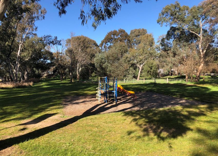
WATERWAY MANAGEMENT PLAN FOR CARISBROOK 2
1 Tullaroop Creek
1.1 INTRODUCTION
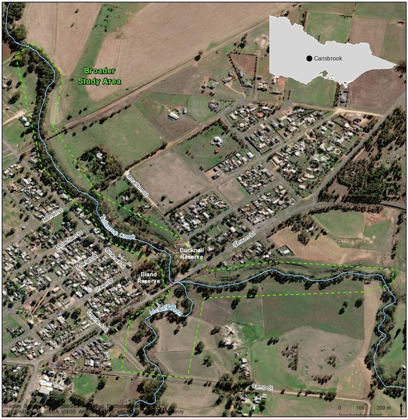
The township of Carisbrook is located at the confluence of Tullaroop Creek
(also referred to as Deep Creek) and McCallum Creek within the broader
Loddon River catchment in central Victoria, approximately 170 km from
Melbourne. The combined catchment area of the two creeks at Carisbrook is
approximately 1,240 km2. The smaller McCallum Creek catchment
encompasses the towns of Waubra, Talbot and Majorca, whilst Tullaroop
Creek catchment includes Clunes, Creswick, Learmonth and Springmount to
the south – refer Figure 1-2.
The section of the creek involved has a history of being used by the town as
a recreational area. It also has a history of significant flooding such as the
severe flooding event in January 2011, which was estimated as a 1 in 135
AEP1 flood event2.
Figure 1-1: Looking upstream along the creek at the Railway Bridge Figure 1-2: Map of the Tullaroop catchment upstream of Carisbrook
1 2
AEP – Annual Exceedance Probability Water Technology, 2013
WATERWAY MANAGEMENT PLAN FOR CARISBROOK 3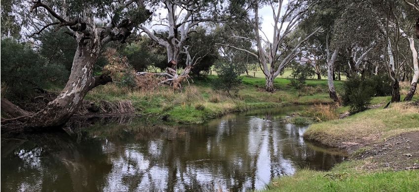
1.2         PURPOSE                                                            1.3        PROJECT SITE

The objectives of the plan are to:                                             The core project site extends from a point approximately 50m south of the
                                                                               Pyrenees Highway (Simpson Street), and the railway bridge approximately
§   Facilitate an extensive engagement process with the Central Goldfields
                                                                               850m north-west of the Highway (shaded yellow). The area includes two
    Shire, Carisbrook community, and key stakeholders to identify priorities
                                                                               public reserve areas being Bucknall and Bland Reserve. The broader project
    for the future management of the Tullaroop Creek and two public
                                                                               area for mitigating flood impacts extends upstream to Camp Street and
    reserve areas being Bucknall and Bland Reserves
                                                                               downstream of the railway line (dotted green line) (Figure 1-3 below).
§   Develop a strategic waterway management plan for Tullaroop Creek
    through Carisbrook that defines the long-term vision, strategic
    objectives and actions for the creek based on the outcomes of the
    community and stakeholder consultation.

More specifically, the plan addresses the following issues:
§   Long term protection and restoration of Tullaroop Creek through
    Carisbrook and its immediate surrounds including Bucknall and Bland
    Reserves
§   Open space design and management, encouraging recreational use
§   Protection and improvement of the landscape character and condition
    of the open space within the creek reserves
§   Opportunities for education and community involvement
§   Planning and development issues and the impact these have on the
    creek corridor.

The plan also recommends:
§   Management practices to protect the values of the project area and
    assist in mitigating the impacts of flood events (including the various
    Authority responsibilities and permit requirements to enable the
    waterway management plan to be implemented).
§   A set of key principles for managing planning and development issues
    impacting the creek environment.

                                                                               Figure 1-3: Overview of project site

WATERWAY MANAGEMENT PLAN FOR CARISBROOK                                                                                                                 4
ENVIRONMENTAL VALUES                                                              Fauna species

The Tullaroop Creek was assessed under the Third Index of Stream Condition        Whilst the Okologie report listed no threatened fauna species being recorded
in 2010, which found the subject reach through Carisbrook (Tullaroop Reach        during their field assessment. The Victorian Biodiversity Atlas7 contains
18) as being in poor condition3. Despite lower ratings for water quality, the     records of 19 listed threatened fauna species in the local area. The Protected
reach scored highly for aquatic life. Carisbrook sits downstream of the           Matters Search Tool8 also identified 20 EPBC Act listed fauna species or
Tullaroop Reservoir, which provides regulated passing flows along this            species habitats (terrestrial) as likely to occur within the local area. However,
section of the creek, which scored a moderate rating for hydrology.               they concluded there was a low likelihood of occurrence for any listed
                                                                                  threatened fauna species due to the modified condition of the creek’s habitat.
Vegetation Condition
                                                                                  Despite this assessment, there are many anecdotal reports and sightings
An assessment of the southern section of the creek’s vegetation, fauna and        captured by the Friends of the Tullaroop who have recorded more common
habitat values was also undertaken in 2019 by Okologie Consulting for the         native species using the creek, such as water rats (or Rakali) (Hydromys
Central Goldfields Shire. In their report4, they highlight DELWP mapping of       chrysogaster) and Platypus (Ornithorhynchus anatinus), Ring-tailed Possums
modelled pre-1750 Ecological Vegetation Classes (EVCs) for the project area       (Pseudocheirus peregrinus) and Common Brush Tail Possums (Trichosurus
would have been predominantly comprised of Creekline Grassy Woodland              vulpecula).
(EVC 68), with Plains Grassy Woodland (EVC 55) in the immediate surrounds.
Current (2005) EVC mapping within the project area shows a modified cover
of these woodland communities5. A subsequent assessment was undertaken
by Water Technology in 20216 as part of this management plan. This
assessment found the creek line is dominated by an overstorey of mixed aged
River Red Gum (Eucalyptus camaldulensis). Thinning of River Red Gums
post flood has left a relatively open stand of trunks while the canopy remains
mostly continuous along both banks throughout the project reach. Wirilda
(Acacia provincialis) is the dominant shrub throughout the project reach. Other
dominant native species observed within the reach include: Blackwood
(Acacia melanoxylon) – a long lived large sub-canopy tree; Bottlebrush
(Callistemon sp.) – a medium sized shrub; Common Reed (Phragmites
australis) – a semi-aquatic perennial reed which can grow in water up to about
1.5 m deep; and Cumbungi (Typha sp.) – a robust emergent aquatic plant will
only persist where there is near permanent water present.                         Figure 1-4: Platypus (Ornithorhynchus anatinus)

3                                                                                 6
    DEPI 2014                                                                         Water Technology, 2021
4                                                                                 7
    Okologie Consulting, 2019                                                         DELWP, 2019a
5                                                                                 8
    DELWP 2019a                                                                       DoEE, 2019

WATERWAY MANAGEMENT PLAN FOR CARISBROOK                                                                                                                          5
ABORIGINAL CONNECTION TO THE CREEK                                                 negotiations for their Recognition and Settlement Agreement held with the
                                                                                   State of Victoria. These sites collectively form a known place of high cultural
The Tullaroop Creek is situated in Dja Dja Wurrung Country. Traditional            significance and a special place for Dja Dja Wurrung men. This would indicate
Aboriginal culture revolved around relationships to the land and water –           that Dja Dja Wurrung people used this area on an ongoing basis and the local
relationships that hold deep physical, social, environmental, spiritual and        waterways would have provided important resources.
cultural significance. Rivers were, and remain, the veins of Dja Dja Wurrung
Country, and provide food and medicine, and places to camp, hunt, fish, swim       Other sites of interest noted during the assessment included:
and hold ceremonies. They are places that are central to their creation stories,
                                                                                   §     Very old established Gum trees along with the Box-Ironbark trees lining
and many of their cultural heritage sites are associated with waterways –
                                                                                         the creek are important for the broader preservation of Dja Dja
burial sites, birthing sites and middens.9
                                                                                         Wurrung cultural landscapes
     Dja Dja Wurrung People have lived on our traditional lands and                §     An area of cultural significance at the junction and floodplain situated
     cared for our Country over many thousands of years. For us,                         under the Simson Street bridge. This was identified as a place of high
     Country is more than just a landscape, it is more than what is visible              impact, a possible meeting place for Dja Dja Wurrung ancestors where
     to the eye, it is a living entity that holds the stories of creation and            the water would have flooded through and ancestors would have put
     histories”10.                                                                       out fish nets made from locally scoured weaving plants. The
                                                                                         significance of this area is heightened by the identification of a specific
A Dja Dja Wurrung Tullaroop Creek site assessment was undertaken by a                    mature gum tree that provides a culturally significant location to hold
Djandak Project Manager, Dja Dja Wurrung Elder and a Dja Dja Wurrung                     Dja Dja Wurrung ceremonies. Mature cultural plants typically used in
Water Policy Officer on 25 November 2020 to observe the health and cultural              smoking ceremonies were also identified within this location, as well as
values of the waterway and surrounding landscape, and to provide a Djaara                native reeds and sedges used in weaving and other cultural activities.
voice to the area. Key elements of their report11 have been captured in this             The combined presence of these plants in one location indicates a
plan.                                                                                    place of high cultural value for the Dja Dja Wurrung which would benefit
                                                                                         from the inclusion of interpretive signage to identify the cultural values
An ACHRIS (Aboriginal Cultural Heritage Register and Information System)                 of this location.
desktop assessment did not reveal any registered cultural heritage sites within    §     The identification of a ring tree located near the railway bridge. The
the assessment area, however, this does not conclude the absence of cultural             established gum tree is located on the banks of the creek with the
heritage along Tullaroop Creek, but more often than not indicates the lack of            branches culturally manipulated to form the shape of a ring. Dja Dja
surveys in the area. An ACHRIS assessment further along Tullaroop Creek,                 Wurrung ancestors would weave the branches of young trees over time
identified cultural heritage registered in the form of a stone arrangement,              to form an identifiable tree that was recognised as a symbol or marker
scarred trees, grinding groves and artefact scatters. Additionally, Dja Dja              for that location.
Wurrung have secured freehold title to a nearby property in Carisbrook under

9                                                                                  11
     RMCG, 2019                                                                         Dja Dja Wurrung Clans Aboriginal Corporation, 2020
10
     Dja Dja Wurrung Clans Aboriginal Corporation, 2014

WATERWAY MANAGEMENT PLAN FOR CARISBROOK                                                                                                                                6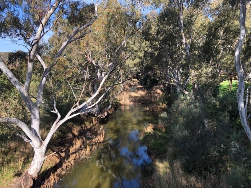
SHORT HISTORY OF CARISBROOK                                                       Carisbrook’s census population in 2016 stands at 856 (representing 8.5 %
                                                                                  growth since 2011), with new residential housing being developed to the east
It is reputed12 that Carisbrook’s name came from ‘Carrie’s Brook’, named after    of the township.
Caroline Bucknall, the daughter of E.G. Bucknall, an early local pastoralist,
who also lent his name to the Bucknall Reserve. However, before the town          As an historic township, Carisbrook includes a number of sites listed on the
was surveyed in 1851 there was a police camp and lock up named Camp               Register of the National Estate, including the log police lock up (c1852) on the
Carisbrook, implying that the name could have had another origin.                 western side of Tullaroop Creek (refer figure 1-4) and Junction Lodge (c1873).

Carisbrook was toward the edge of the Maryborough goldfields, but a good
water supply from the Tullaroop Creek underpinned its prosperity. Local
landowners Joyce and Simson opened a flour mill in 1856. The first store
opened in 1853 and an Anglican church and school began in 1855. There
were bakeries, a brewery, four hotels, brickyards and several stores when
Carisbrook was proclaimed a borough on 7 August 1857. A railway station
was opened when the line was constructed in 1874. Carisbrook competed
with Maryborough for a few years for district leadership, but Maryborough’s
centrality in the goldfields gave it prosperity that was unavailable to
predominantly agricultural Carisbrook. At about the time of its peak census
population of 1,236, Carisbrook was described in the Australian handbook,
1903.

On 1 October 1915, when the borough’s population was fewer than 1000, it
was united with the Tullaroop shire. The area’s agricultural economy kept the
town’s population from falling under 300, and civic works such as tree planting
and improvement of reserves (including the Tullaroop Creek) took place. The
railway station and goods shed are no longer used.
                                                                                  Figure 1-4: View to Tullaroop Creek of the historic Carisbrook log jail
In September 2010 and again in January 2011 many parts of regional Victoria
experienced widespread severe flooding. In Carisbrook the town was
completely inundated from floodwater in Tullaroop Creek with 800 people
evacuated and many homes damaged. More than 190 houses, two churches
and a club were inundated.

12
     https://www.victorianplaces.com.au/carisbrook

WATERWAY MANAGEMENT PLAN FOR CARISBROOK                                                                                                                         7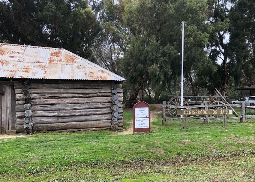
MANAGEMENT TODAY                                                                                    ADJOINING LAND USE

The Creek area is reserved Crown land managed by the Central Goldfields                             The western side of the creek heading north west downstream from Bland
Shire Council and the Department of Environment Land Water and Planning                             reserve adjoins established residential development of Carisbrook and the
(DELWP). Bland and Bucknall reserves including the car park and grass area                          historic Carisbrook log jail.
are managed by the Council, and the remainder managed directly by DELWP.
(refer Figure 1-5 which shows the creek reserve and sections subject to Water                       The eastern side of the creek adjoins rural residential property adjoining
Frontage Licences).13 The railway reserve at the end of the northern end of                         Bucknall reserve and further downstream to the north east an agricultural
the Creek reserve is managed by Vic Track Corporation and the Pyrenees                              grazing property, which also holds a Water Frontage Licence over the creek.
Highway at the southern is managed by the Department of Transport.
                                                                                                    LAND USE PLANNING PROVISIONS

                                                                                                    The majority of the creek is subject to Public Park and Recreation Zone under
                                                                                                    the Central Goldfields Planning Scheme, and is subject to the following
                                                                                                    overlays below (and shown in Figure 1-6):
                                                                                                    §   Schedule 209 (Carisbrook area) to the Heritage Overlay (HO209),
                                                                                                        which aims to protect the historic character of Carisbrook.
                                                                                                    §   Schedule 1 to the Environmental Significance Overlay (ESO1), which
                                                                                                        aims to
                                                                                                        -   Prevent pollution and increased turbidity of water in water
                                                                                                            storages, watercourses and channels.
                                                                                                        -   Restrict and regulate developments which may interfere with the
                                                                                                            use of water for agricultural, domestic or other purposes.
                                                                                                        -   Preserve existing native vegetation and to promote regeneration of
                                                                                                            native vegetation.
                                                                                                        -   Contribute to the enhancement of water quality throughout the
                                                                                                            Murray-Darling Basin.
                                                                                                        -   Maintain the ability of streams and watercourses to carry natural
                                                                                                            flows.
Figure 1-5: Crown land tenure (including Water Frontage Licences)
                                                                                                        -   Protect and encourage the long-term future of flora and fauna
                                                                                                            habitat in and along watercourses and water storages.

13
     http://mapshare.vic.gov.au/MapShareVic/index.html?viewer=MapShareVic.PublicSite&locale=en-AU

WATERWAY MANAGEMENT PLAN FOR CARISBROOK                                                                                                                                          8
§ Schedule 1 to the Land Subject to Inundation Overlay (LSIO1), which COMMUNITY USE AND RECREATION
aims to:
- To identify land in a flood storage or flood fringe area affected by The creek is well used by local residents and visitors. On the western bank,
the 1 in 100 year flood or any other area determined by the an unsealed shared trail runs from Bland Reserve from the pedestrian bridge
floodplain management authority. (at Green Street) and along the toe of the creek embankment to McNeil Street,
becoming undefined to the railway bridge at the northern ed of the reserve.
- To ensure that development maintains the free passage and
This walking track, which adjoins the town of Carisbrook appears the most
temporary storage of floodwaters, minimises flood damage, is
popular – but is undefined for a third of its length. Another trail on the eastern
compatible with the flood hazard and local drainage conditions and
bank of the creek, joined by a pedestrian bridge at the end of Green Street,
will not cause any significant rise in flood level or flow velocity.
continues the walking track at Heape Street, where the track heads north east
- To protect water quality in accordance with the provisions of State away from the township. There are four access points down to the trail from
Environment Protection Policy (Waters of Victoria). the Township of Carisbrook, McNeil, McLaughlin, Powlett and Greens Streets.
- To ensure that development maintains or improves river and On the eastern side of the creek, the creek can be accessed from Heape
wetland health, waterway protection and flood plain health. Street and from the Bucknall Reserve off McCallum Street.
There is a well used playground in Bland Reserve, together with a car park at
the end of Green Street. Bucknall Reserve, which is joined to Bland Reserve
via a pedestrian bridge has been historically planted out with ornamental
LSIO1
exotic trees and contains a toilet block and car park for public visitor’s use.
The local Friends of Carisbrook Creek Community Group has been
extensively involved in the planning and management of the reserve’s
vegetation and walking trails, and have established seating and a series of
interpretive signs along the eastern bank of the creek to highlight its history
and environmental values, including past floods.
STRATEGIC DIRECTIONS
The creek and surrounding catchment are also the subject of a number of
broader regional and issue-specific strategies and plans developed by the
North Central CMA, Council, Central Highlands Water, the Dja Dja Wurrung
Clans Aboriginal Corporation and the Victorian Government.
Figure 1-6: Planning overlays
WATERWAY MANAGEMENT PLAN FOR CARISBROOK 9These strategies, which have been considered in developing management § Central Highlands Integrated Water Management Strategic
recommendations include: Direction Statement (DELWP, 2019) – identifies collaborative IWM
opportunities that can improve resilience and liveability in cities and
§ North Central Regional Catchment Strategy (2013-2019) provides
towns in the region, including the following outcomes:
long-term vision for Natural Resource Management (NRM) within the
North Central Catchment Management Authority region, including the - Healthy and valued waterways, wetlands and waterbodies
Tullaroop catchment. The RCS sets regional priorities for the - Healthy and valued landscapes
management of natural assets, sets overall direction for investment and - Avoided or minimised existing and future flood risks.
coordination of effort by landholders, partner organisations and the wider
§ Maryborough Integrated Water Management Plan (2018) - report
community. It provides a framework that supports and encourages
prepared for Central Highlands Water, Central Goldfields Shire and
participation in protecting and enhancing our environment.
North Central Catchment Management Authority. The Maryborough
§ North Central Waterway Strategy (2014-2022) - provides a single, Integrated Water Management Plan explores and sets out
regional planning document for waterway management and a high-level recommendations for future water management in the Maryborough
regional works program to guide investment. The Strategy is an area, including Carisbrook. The Plan examines the whole urban water
important framework for the North Central CMA in partnership with other cycle, including the management of stormwater, wastewater, water
agencies, Traditional Owners and the community to manage the region’s supplies and waterways. It also considers how water can be managed
waterways, including the Tullaroop Creek and builds upon the 2013-19 to deliver community benefits such as enhanced amenity, greener open
North Central Regional Catchment Strategy. spaces and street trees and enhanced recreational opportunities.
§ North Central Floodplain Strategy (2018-2028) – provides a single, § Dhelkunya Dja - Dja Dja Wurrung Country Plan (2014-2034) – the
regional planning document for floodplain management within the North Country Plan will provide direction for the Dja Dja Wurrung Clans
Central CMA region, and a high-level regional work plan to guide future Aboriginal Corporation and the Traditional Owner Land Management
investment priorities. This strategy, which was developed by the North Board to build partnerships with key stakeholders and to increase the
Central CMA in partnership with local government, including the Central involvement of Dja Dja Wurrung Traditional Owners in the effort to
Goldfields Shire, informs future management of flood risk within achieve their goals for Country. It is about re- affirming their aspirations
Carisbrook, in line with the 2013 Carisbrook Flood and Drainage and describing the future of their people, the Traditional Owners of Dja
Management Plan Final Study Report. Dja Wurrung Country. It recognises the importance of their cultural
§ Biodiversity 2037 (DELWP, 2017) – provides the Victorian heritage – significant places and landscapes, stories and language,
Government’s overarching strategy for investing together to protect the customs and practices and responsibilities for looking after Country. It
environment, linking society and the economy to the environment, describes the pathway the Dja Dja Wurrung community has determined
working with Traditional Owners and Aboriginal Victorians and better it needs to take to rebuild and prosper.
protection and management of regional biodiversity.
WATERWAY MANAGEMENT PLAN FOR CARISBROOK 10Bland Reserve
WATERWAY MANAGEMENT PLAN FOR CARISBROOK 11
Playspace2 What we heard? 2.1 FINDINGS
VISION
The Carisbrook community was encouraged to contribute their views as a
foundation to shape the development of this waterway management plan. The Community members were asked to think about how they wanted to see the
consultation period was open between 27 September and 14 October 2020. creek in 10-20 year’s time. Many residents hoped to see the creek return to
Due to the COVID-19 restrictions in place at the time, planned face-to-face its look and feel from their youth; more swimming, more wildlife, more
workshops were deferred. Instead, an interactive map was developed for vibrance. While others focused on the promotion of natural and cultural
residents to pinpoint their ideas, observations and issues. 12 residents shared values. A sample of responses is included below.
their insights through this map (Figure 2-1). These residents, alongside an
additional 24 community members completed an online or hardcopy survey. “Natural environment that is resilient in coping with climate change and
providing community access for people and their pets to enjoy it.”
“A waterway that retains its natural feel, good connection to the waterway,
space where people feel safe to walk and enjoy, a healthy waterway
with fish and other animals. Not overgrown with exotics”
“A healthy waterway, acknowledged and protected the community
and local government.”
“I want my children to return with their children and remember the
place and recognise it and appreciate the improvements.”
“Like what it was 20-50 years ago. Children and adults could swim there.
Water flowed and was clean. Platypus were there. Not a flood or fire
danger to town.”
“I would like to see the community as well as visitors to the town utilise the
creek area for all sorts of recreation and gatherings. Creek areas within
Figure 2-1: Tullaroop Social Pinpoint Map14 town areas should benefit the people in the town”.
14
https://rmcg.mysocialpinpoint.com/tullaroop-creek/map#/
WATERWAY MANAGEMENT PLAN FOR CARISBROOK 12ACTIVITIES AND USE FUTURE MANAGEMENT
Frequency and type of use of the creek is diverse among respondents (Figure The following word map from the Social Pin Point comments highlights key
2-2 and Figure 2-3), reflecting the range of opportunities available for such a aspects of the creek the community would like protected or enhanced.
natural asset so close to the community.
What physical activities do you enjoy when you
visit the creek?
Play
Fish
Sit Below is a snapshot of other key aspects the community raised, which have
Swim
been used to inform the objectives and management actions under this plan.
Run
A majority of feedback provided on the interactive map focused on
Cycle
opportunities for extending and connecting the walking trail.
Walk Suggestions included extending the track from Heape Street, across this
0% 20% 40% 60%. 80% 100% viaduct and back to the log Jail. Issues arising from private land ownership
were noted, but respondents overwhelming saw significantly recreational and
Figure 2-2: Physical activities community benefit in exploring options for an extension.
Clearing vegetation within the waterway (exotic weeds and native reeds)
What social activities do you enjoy when you was highlighted as an opportunity to increase flows and improve access
visit? for swimming. Several residents identified waterway constraints as a
Play/informal… potential flood risk, while others focused on the aesthetic appeal of improved
waterway flows.
BBQ
A range of views were presented on the presence of non-native
Picnic vegetation (trees) in the two reserves. Some considered these ‘exotics’ to
Walk together be deeply intertwined with the recent ‘spirit’ of the park, while others hoped to
promote a more native or natural feel to the park.
0% 20% 40% 60%. 80% 100%
Acknowledgement and promotion of the creek’s cultural heritage was
Figure 2-3: Social activities highlighted as an important gap. Several respondents suggested more
work must be done to incorporate and pay respect to the Traditional Owners
of the Country, the Dja Dja Wurrung People.
WATERWAY MANAGEMENT PLAN FOR CARISBROOK 132.2 MANAGEMENT ISSUES
In response to a desktop review, multiple site inspections and community
feedback, the following highlight some of the key management issues
identified.
Informal or limited public access throughout the creek reserve
Whilst there are well maintained unsealed walking/ cycling tracks along much Figure 2-5: Stormwater outfall off McNeil Street
of the creek reserve and a pedestrian bridge linking the Bucknall and Bland
Reserves, the track becomes informal towards the northern end of the Flood protection and vegetation management
western bank and is unpassable on the eastern side due an existing Water
Frontage Licence, just south of the railway bridge. Accordingly, there is no Following the major flood events of 2010-11 (refer Figure 2-6), North Central
easily means to walk the entire length of the track, nor is it suitable for disability Catchment Management Authority, in collaboration with the Central Goldfields
access, which is important providing access to all, including elderly members Shire and the local community developed the 2013 Carisbrook Flood and
of Carisbrook. Drainage Management Plan15, which included reducing the impact of
vegetation (such as exotic vegetation, thinning of native vegetation and fallen
trees between Camp Street and downstream of the railway line). The purpose
of the plan was to better understand the impacts of flooding on the township
and identify options to reduce the potential impacts to the community.
The Central Goldfields Shire was successful in obtaining funding to implement
the recommendations of the plan, which included reducing the impact of
vegetation (such as exotic vegetation and fallen trees near the Pyrenees
Highway bridge) in the Tullaroop and McCallum Creeks in line with the
management recommendations of the Carisbrook Flood Management Plan.
Figure 2-4: Fenced area at the north eastern end of the reserve
Under these recommendations, Council has identified the need to undertake
Stormwater erosion off Carisbrook township
ongoing management and maintenance of vegetation through the reserve to
mitigate any further effects of future flooding, whilst protecting significant
Stormwater outfalls from Carisbrook (see Figure 2-5) flow overland directly to
areas of native vegetation, which it wishes to retain, protect and enhance.
the creek through a series of stormwater outlet pipes that are causing erosion
at their discharge points.
15
Water Technology, 2013
WATERWAY MANAGEMENT PLAN FOR CARISBROOK 14There is also sediment build up underneath the Pyrenees Highway bridge that Landscape and signage
will need careful examination and maintenance to enable adequate flow
convenance during high stream flows reduce erosion at the base of the bridge. The Bucknall and Bland Reserves are popular with the local community and
visitors to Carisbrook, and are inextricably linked to the history of the Tullaroop
Creek. However, many of the original exotic trees planted within the reserves,
such as the poplars are now showing signs of stress or senescence, and from
some vantage points are blocking natural view lines to the creek, and the
reserve’s connection to the creek. Physical access to the creek is also
important for past recreational practices such as swimming and fishing,
however, this access is no longer easily accessible in this area due to
regrowth of exotic vegetation and native reeds.
The reserve also has extensive interpretive signage, established by the
Friends of the Tullaroop Creek, that promotes its natural values and features
and the local history of the Carsibrook. Although still intact, the signage could
be renewed and expanded (refer Figure 2-7).
Figure 2-6: Carisbrook in flood in 201116 As part of a process of renewing this signage, there is an opportunity to better
capture and promote Traditional Owner connections to the creek.
Biodiversity protection and weed management
The Tullaroop Creek is valued for its natural environment, which includes its
River Red Gum dominated Creekline Grassy Woodland, and the habitat it
provides for a range of instream and riparian species. The importance of
protecting this stream environment, is captured in a range of broader
strategies (refer page 10 above) and recent vegetation assessments1718, and
is central to the character and well-being of the Carisbrook community. The
recent vegetation assessment19 found that despite the extensive clearing of
exotic vegetation post flooding, a few species continue to emerge from seed
distribution. Desert Ash (Fraxinus angustifolia) have been observed
throughout the project reach, particularly at the upstream end, and Poplar and Figure 2-7: Trail signage along Tullaroop Creek.
Blackberry have also observed across the project area.
16 18
Water Technology, 2013 Water Technology, 2021
17 19
Okologie Consulting, 2019 Ibid
WATERWAY MANAGEMENT PLAN FOR CARISBROOK 153 The Plan
3.1 LONG-TERM VISION
Tullaroop Creek is the centrepiece of Carisbrook:
§ known for its peaceful landscape and natural values;
§ a place where its history and cultural connections past and present are
understood and respected; and
§ where all can enjoy safe access.
3.2 STRATEGIC OBJECTIVES
The Waterway Management Plan for Carisbrook is guided by five
objectives. These objectives form the main areas of focus under which a
series of goals and management recommendations have been identified.
1. Further develop and maintain the Bland and Bucknall reserves as a
significant open space for passive use
2. Develop the Creek Corridor to better support active recreation activities
3. Build a connection with the place
4. Protect and enhance the creek’s natural values
5. Improved governance and risk management, including management of
flood risk.
The management recommendation’s underpinning the objectives are
presented in the following sections. Broad timeframes for implementation
have been assigned to each action and include: Short (1–3 years), Medium
term (4–7 years), (8-10 years), and ongoing.
These recommendations should be read alongside the four open space site
plans for the creek in Appendix 1 (two at a scale of 1:2000 and two more
detailed plans for the Bucknall and Bland Reserves at a scale of 1:1000).
WATERWAY MANAGEMENT PLAN FOR CARISBROOK 163.3 OBJECTIVE 1: FURTHER DEVELOP AND MAINTAIN THE BLAND AND BUCKNALL RESERVES
AS A SIGNIFICANT OPEN SPACE FOR RECREATIONAL USE
GOALS Both reserves would also benefit from upgrades to the existing interpretive
signage, which although extensive and detailed is in need of renewal. This
§ Improve accessibility
would provide an opportunity to better promote the site’s Traditional Owner
§ Respond to community preferences regarding presentation connections alongside the creek’s natural values and local history.
§ Restore the relationship to the Creek and maintain significant view lines
§ Upgrade the play space. The play space in Bland Reserve is popular with visitors to the creek, and
when the facility reaches the end of its service life, it should be upgraded to a
CONTEXT local space that incorporates a more natural style and safety features.
Through the public consultation phase, 83% of respondents identified PRINCIPLES
accessibility for all as very important with a focus on improved condition of the
existing gravel paths to be Disability and Discrimination Act (DDA) compliant. The following management recommendations will be undertaken according to
the following principles:
Many of the original exotic trees planted within Bucknall Reserve, such as the
poplars are now showing signs of stress or senescence, and from some § All planned new or upgraded reserve infrastructure must consider
vantage points are blocking natural view lines to the creek, and the reserve’s potential impacts on trade and visitation in the town of Carisbrook
connection to the creek. Many in the community also identified the grass
environments of both reserves and available shade as also very important to § Preference should be given to the use of natural and unobtrusive
be maintained. materials for any infrastructure installations and upgrades; and where
appropriate, engage specialist expertise to assist with the design of new
As part of the plan to improve the landscape character and sight lines across structures (or major upgrades) such the toilet block or play space
the reserves, new trees should be selected to replace specimens in poor
health. Species selection should give consideration to the historic landscape § Ensure any planned removal or maintenance of regenerating reeds or
character of the reserves. cumbungi (Typha domingensis), is targeted to specific locations requiring
creek access, is the minimum necessary to afford such access and
The consultation also identified physical access to the creek as important for accords with the requirements for native vegetation removal under
historical recreational purposes such as swimming and fishing and Section 52.17 of the Central Goldfields Shire Planning Scheme
encouraged the removal or maintenance of reeds from the creek’s edges. To
allow greater community use of the creek at key locations, any reed removal § Any replacement trees in the reserves should give consideration to
would need to be accompanied by firm, well graded and appropriately finished historic landscape character of the reserves.
areas and subject to relevant planning and other approvals (refer section 3.7).
WATERWAY MANAGEMENT PLAN FOR CARISBROOK 17MANAGEMENT RECOMMENDATIONS
GOA L N O. R E C OMME N D E D A C T I ON T I ME F R A ME
OBJECTIVE 1 - Further develop and maintain the Bland and Bucknall reserves as a significant open space for community use
Improve 1.1.1 Ensure Disability and Discrimination Act (DDA) compliant paths connect key infrastructure including car park, Medium
accessibility seats, picnic tables, bridge and toilets.
1.1.2 Install asphalt or concrete paths in areas where gravel cannot be maintained. Medium
1.1.3 Ensure reserve environment is developed in line with Crime Prevention through Environmental Design (CPTED) Medium
guidelines to increase perception of safety.
Respond to 1.2.1 Maintain as a predominantly grassed environment with shade trees. Short
community
preferences 1.2.2 Ensure that improvements are designed to achieve the community’s preference for a neatly maintained Short
regarding environment.
presentation
Restore the 1.3.1 Improve physical access to the creek by removing regenerating reeds at targeted locations from the creek’s Ongoing
relationship to the edges and grassing to the water’s edge.
Creek and maintain
significant view lines 1.3.2 Allow for community use of the Creek for recreational purposes such as swimming and fishing by providing firm, Short
well graded and appropriately finished areas.
1.3.3 Open up views across the creek, by removing strategic exotic vegetation, including poplar trees. Medium
1.3.4 Install interpretive signage focusing on historic images of the Creek and verified first person recollections. Medium
1.3.5 Install interpretive signage focusing on the local history of the Traditional Owners. Medium
1.3.6 Install new reserve trees to replace specimens in poor health, selecting species with consideration of the site’s Medium
historic landscape character.
Upgrade the play 1.4.1 When the existing facility reaches the end of its service life, upgrade to a local space that incorporates natural Long
space style features.
WATERWAY MANAGEMENT PLAN FOR CARISBROOK 183.4 OBJECTIVE 2: DEVELOP THE CREEK CORRIDOR TO BETTER SUPPORT RECREATION
ACTIVITIES
GOALS If the bridge cannot be used as a pedestrian bridge, then this would require a
detailed investigation to install a second crossing that considered flow
§ Improve accessibility
conveyance and fish passage.
§ Explore the creation of a circular walking track
§ Restore the relationship to the Creek. This circular trail option would also need to examine a review of the Crown
Water Frontage Licence east of Creek with a view to negotiate and provide
CONTEXT public access.
Through the public consultation phase, 83% of respondents identified PRINCIPLES
accessibility for all as very important with a focus on improved condition of the
existing gravel paths to be Disability and Discrimination Act (DDA) compliant. The following management recommendations will be undertaken according to
For example, asphalt or concrete paths should be installed in areas where the following principles:
gravel cannot be maintained.
§ Any future pedestrian creek crossing at the northern end of the project
There are several locations where bench seating has been set up for walkers site must consider impacts on flows, flooding and fish passage and the
to rest and enjoy the creek environs. These appear to be still in relatively good immediate environment, and be of a form sympathetic to the historic and
condition and would not be a priority for replacement at this stage. natural landscape character of the creek
The consultation also identified physical access to the creek as important for § Preference should be given to the use of natural and unobtrusive
historical recreational purposes such as swimming and fishing and materials for any new interpretive signage; and where appropriate,
encouraged the removal or maintenance of regenerating reeds from creek’s engage specialist expertise to assist with their design
edges. To allow greater community use of the creek at key locations, any reed
removal would need to be accompanied by firm, well graded and appropriately § Ensure any planned removal or maintenance of regenerating reeds or
finished areas and subject to relevant planning and other approvals (refer cumbungi (Typha domingensis), is targeted to specific locations requiring
section 3.7). creek access, is the minimum necessary to afford such access and
accords with the requirements for native vegetation removal under
A number of the community respondents identified extending the gravel Section 52.17 of the Central Goldfields Shire Planning Scheme
walking track to the railway line both sides of creek to establish a circular
walking track or loop to facilitate improved user (pedestrian or cycling) § Where grades permit at the specified locations, remove vegetation,
experience using the rail bridge as a crossing point. smooth and grass slopes to the water’s edge to allow for efficient ongoing
maintenance by the Shire.
WATERWAY MANAGEMENT PLAN FOR CARISBROOK 19MANAGEMENT RECOMMENDATIONS
GOA L N O. R E C OMME N D E D A C T I ON T I ME F R A ME
OBJECTIVE 2 - Develop the Creek Corridor to better support recreation activities
Improve 2.1.1 Review and upgrade gravel paths to a higher standard of DDA compliance. Medium
accessibility
2.1.2 Asphalt or concrete paths should be installed in areas where gravel cannot be maintained. Medium
2.1.3 Ensure reserve environment is developed to in line with CPTED guidelines to increase perception of safety. Medium
Explore the creation 2.2.1 Review Crown land licence east of creek to provide public access. Medium
of a circular walking
track 2.2.2 Extend the gravel walking track to the railway line both sides of creek. Long
2.2.3 Review any encroachments into the creek reserve. Long
2.2.4 Install a waterline-level connection across the creek at the northern end of the creek reserve that will not impede Long
water flow, and also allows movement of aquatic species up and downstream.
2.2.5 Connect the creek’s circular paths to surrounding streets. Long
2.2.6 Install DDA seating and interpretive signage at strategic points along the track. Medium
Restore the 2.3.1 Provide greater physical access to the creek for users by reducing the areas of woody weeds, non-eucalypt Ongoing
relationship to the seedlings and regenerating reeds along the creek corridor at targeted locations.
Creek
WATERWAY MANAGEMENT PLAN FOR CARISBROOK 203.5 OBJECTIVE 3: BUILD A CONNECTION WITH PLACE
GOALS Traditional Owner connections
§ Improve accessibility
There are many steps the Council can take to acknowledge the past, build
§ Reflect on the Creek's history in the development of Carisbrook relationships and incorporate the significance of Aboriginal culture and history
§ Acknowledge the importance and ongoing connection of the Creek to into the management of Tullaroop. Commencing discussions with Dja Dja
its Traditional Owners, Dja Dja Wurrung and Aboriginal Victorians Wurrung elders will be central to this process and it is essential that
§ Restore the relationship to the Creek. discussions be guided by what Traditional Owners would like to see at
Tullaroop Creek, not what others think should occur. This means asking
CONTEXT questions such as, “What does acknowledgement and recognition look like
for Aboriginal people?” and “How would they like their stories represented?”
History and connection to the creek
Over time it is hoped that more substantial activities will take place, which may
As detailed in Section 1, Tullaroop Creek has long been associated with the include cultural walks, the sharing of Elders’ stories with visitors to creek and
history and development of Carisbrook. revegetation with bush foods.
For local people, the history of the settlement of Carisbrook continues to be PRINCIPLES
an important part of the Tullaroop story. The community is particularly
interested in history at Carisbrook and its heritage (including the log jail), its The following management recommendations will be undertaken according to
natural landscape and recent major events such as the 2010-11 floods. the following principles:
Through the community surveys, the importance of the creek to the recreation
life of the Carisbrook was revealed, highlighting swimming, fishing and family § Set up an ongoing partnership with the creek’s Traditional Owners, Dja
gatherings that took place over more recent history. Dja Wurrung about Aboriginal heritage matters and Traditional Owner
connection to the creek.
There is an opportunity to improve this connection and history through an
upgrade of the existing interpretive signage with focus on the town’s history § Support active community engagement with the Creek through volunteer
and natural values, improved access to the creek for recreational activities. groups such as Friends of Tullaroop Creek and Landcare, and encourage
The neighbouring heritage precinct on the western section of the creek and support greater participation from younger members of the
provides an opportunity for increased visitor use and regional tourism community.
experiences – by connecting to the planned loop trial and upgraded signage.
Ongoing community involvement and participation through a reinvigorated
Friends Group is critical to this outcome.
WATERWAY MANAGEMENT PLAN FOR CARISBROOK 21MANAGEMENT RECOMMENDATIONS
GOA L N O. R E C OMME N D E D A C T I ON T I ME F R A ME
OBJECTIVE 3 - Build a connection with the place
Provide 3.1.1 Install new interpretive signage (that builds on existing signage) along the circular Creek track to provide Short
environmental information on healthy waterways, local ecosystems, flora and fauna and flood management.
education
Reflect on the 3.2.1 Install interpretive signage to the reserves focusing on historic images of the Creek and verified first person Short
Creek's history in recollections.
the development of
Carisbrook
Acknowledge the 3.3.1 Install interpretive Dja Dja Wurrung signage focusing on Traditional Owner connection and cultural values. Medium
importance and Signage should include an acknowledgment of the Traditional Owners of the land and interpretive signage
ongoing connection informing visitors of the cultural heritage of the site, food and fibre in the area and the traditional uses of these
of the Creek to its plants.
Traditional Owners,
Dja Dja Wurrung and 3.3.2 Commence discussions with the Traditional Owners Dja Dja Wurrung to inform future management actions as a Ongoing
Aboriginal step towards acknowledging the past and building future partnerships. This should include Dja Dja Wurrung
Victorians involvement in management and monitoring of the waterway over time, including any future management plans
being developed for the area.
3.3.3 Undertake a detailed cultural heritage survey of the area by Dja Dja Wurrung, to ensure all cultural heritage sites Short
identified during the assessment are recorded and protected.
3.3.4 Dja Dja Wurrung to lead revegetation of food, fibre and medicine plants into the Tullaroop Creek waterway and Medium
surrounding landscape.
Enhance community 3.4.1 Encourage and support private and public community gatherings. Medium
partnerships
3.4.2 Encourage and support the activities and agency of the Friends group. Short
WATERWAY MANAGEMENT PLAN FOR CARISBROOK 223.6 OBJECTIVE 4: PROTECT AND ENHANCE THE CREEK’S NATURAL VALUES
GOALS PRINCIPLES
§ Increase understanding of the native flora and fauna
The following management recommendations will be undertaken according to
§ Identify, protect and enhance native vegetation the following principles:
§ Reduce the spread and impact of weeds and pest animals
§ Ensure only indigenous plant species are used in revegetation works,
§ Promote integrated water management principles for stormwater except in the Bland and Bucknall Reserves.
management.
§ Ensure native grasses and low understorey species are included as
part of revegetation work, to encourage greater biodiversity outcomes.
CONTEXT
This will contribute to more diverse plantings that over time will provide
Amongst the main reasons that people visit the creek is the opportunity “to be greater habitat values for native wildlife, from ground-dwelling
in nature” and to appreciate the natural history of the site. This was reflected mammals to birds.
in the community responses to the survey. The protection of remnant native § Focus revegetation in areas that protect significant view lines of the
vegetation and the planting of more native vegetation also rated highly creek
amongst community as important management actions for the creek. § Adopt the 1999 Urban Stormwater Best Practice Environmental
Management Guidelines in managing stormwater outfalls to the creek
There is a need to protect and enhance existing remnant indigenous
§ Undertake revegetation works in a manner sympathetic to the
vegetation including Floodplain Riparian Woodland and Riparian Woodland
principles of good floodplain management. This should include low
Communities. There is a challenge for the Council to strike a balance between
understorey species and overstorey trees with a light scattering of mid
revegetating to increase the biodiversity of the creek to protect and enhance
storey shrubs.
the natural values, whist managing flood risk and retain the existing
recreational use and views. § The aim of the planting should be to out compete weed species,
provide for easier maintenance and a self-managing system whilst not
Minor stormwater erosion is occurring on the western bank of the creek. In exacerbating flood risk.
line with Integrated Water Management principles20, the stormwater outfalls
should be reviewed with view to adopt more water sensitive design outcomes,
that minimise erosion, and the establishment of swale drains and filter strips
planted with native species and pools for aquatic habitat. This could be
enhanced by a stormwater education campaign promoting the connection
between stormwater run-off and the creek’s health.
20
DELWP, 2019
WATERWAY MANAGEMENT PLAN FOR CARISBROOK 23MANAGEMENT RECOMMENDATIONS
GOA L N O. R E C OMME N D E D A C T I ON S T I ME F R A ME
OBJECTIVE 4 – Protect and enhance the creek’s natural values
Increase 4.1.1 Undertake a comprehensive flora and fauna assessment. Short
understanding of the
creek’s native flora 4.1.2 Install new interpretive signage (that builds on existing signage) along the existing creek track to provide Short
and fauna information on healthy waterways, local ecosystems, flora and fauna, Traditional Owner values and flood
management.
Identify, protect and 4.2.1 Prioritise key areas for native vegetation management, protection and enhancement based on flood risk and Short
enhance native biodiversity.
vegetation
Reduce the spread 4.3.1 Undertake staged weed control program to promote active regeneration of floodplain riparian woodland Short
and impact of weeds communities on the creek side of the existing paths, using the path as a management boundary to minimise
and pest animals reinvasion of ground layer weeds from the adjoining residential and rural residential areas.
4.3.2 Prioritise management of weeds (exotic plant species) to reduce flood risk. Ongoing
Promote Integrated 4.4.1 Target source litter control and promote education about the impacts of stormwater run-off on the creek, and the Medium
Water Management opportunities presented through Integrated Water Management.
outcomes
4.4.2 Restore the eroded stormwater outlet at McNeil Street in line with the 1999 Urban Stormwater Best Practice Medium
Environmental Management Guidelines.
WATERWAY MANAGEMENT PLAN FOR CARISBROOK 243.7 OBJECTIVE 5: IMPROVED GOVERNANCE AND RISK MANAGEMENT
GOALS Flood and other risks
§ Establish and coordinate a creek management reference group with It is important that key risks in managing the creek reserve, are captured and
high level community and stakeholder representation implemented. This includes ongoing management of flood risk through
§ Establish and maintain and asset management database for the creek targeted vegetation management identified through the 2013 Carisbrook
§ Establish a risk management plan (including flood and bushfire risk). Flood and Drainage Management Plan.
CONTEXT Prior to, and during, the development of the Carisbrook Flood Plan, residents
raised concerns about vegetation in the waterways. Residents were
Improved governance particularly concerned about the exotic vegetation that choked the waterways
upstream of the Pyrenees Highway, as well as trees that had fallen or had the
Tullaroop Creek is central to the history, character, landscape and function of potential to fall and block the waterways.
the Carisbrook township. It is therefore important that Council can draw on
key community members and stakeholders to assist in its ongoing The North Central CMA in partnership with the Central Goldfields Shire
management. This input would be best served through establishment of a undertook vegetation removal works in 2011-12, funded by the Victorian
creek management reference group that could involve more formalised Government, to remove exotic vegetation and many fallen trees near the
community and stakeholder involvement, as well as oversight and review of Pyrenees Highway bridge. Flood modelling undertaken in the development of
this waterway management plan. The creek management reference group the Carisbrook Flood and Drainage Management Plan demonstrated the
should be supported by an agreed term of reference, meet at least annually, benefit of these works and identified the potential for additional works to
and at a minimum include representation from the Carisbrook community and further reduce the flood risk to Carisbrook. These additional vegetation
creek users, Friends Group, key agencies, such as the North Central CMA, management works were completed in 2016.
DELWP and Traditional Owners, Dja Dja Wurrung.
The purpose of the vegetation management is to assist in:
Council is the Committee of Management for only a proportion of the creek § Reducing the potential for water to break out of McCallum Creek
(Bland and Bucknall Reserves) and should work with DELWP to consider upstream of Carisbrook; and
extending that status to the entire reserve between the two bridges.
§ Increase the efficiency of water flowing in Tullaroop Creek through the
Asset management Pyrenees Highway bridge to, and past, the railway bridge.
As highlighted above, the Creek contains a series of Council owned and/or The report authors note that the vegetation management in combination with
managed community assets, including toilet blocks, ornamental trees, paths the western levee works will protect Carisbrook from large flood events that
and benches and signage. To ensure an orderly asset maintenance and may occur on average once every 50 years. However, Carisbrook is likely to
replacement, the establishment of a spatial asset resister is recommended. still experience riverine flooding in a repeat of a January 2011 flood event.
WATERWAY MANAGEMENT PLAN FOR CARISBROOK 25PRINCIPLES STATUTORY ENVIRONMENTAL APPROVALS
The following management recommendations will be undertaken according to Any works and activities planned under this waterway management plan
the following principles: would require planning approval under provisions of the Central Goldfields
Planning Scheme. These include:
Flood risk management works
Zones:
§ Any works planned to manage flood risk should be supported by the
§ Public Park and Recreation Zone (PPRZ)
development of a Construction Environment Management Plan
(CEMP)21 that include actions to avoid potential impacts to the creek’s Overlays:
ecological values. The CEMP should include as a minimum:
§ Schedule 209 (Carisbrook area) to the Heritage Overlay (HO209)
- Evidence of required statutory approvals (refer below).
§ Schedule 1 to the Environmental Significance Overlay (ESO1)
- An induction for contractors regarding ecological values throughout
§ Schedule 1 to the Land Subject to Inundation Overlay (LSIO1)
the site.
§ Schedule 1 to the Floodway Overlay (FO).
- Designated No Go Zones to avoid any disturbance or damage to
native vegetation/waterway. No go zones should be fenced with Native vegetation controls – under Section 52.17, which aims to ensure
para-webbing or similar material prior to construction. that there is no net loss to biodiversity as a result of the removal, destruction
- Pruning of any indigenous trees should be undertaken by a or lopping of native vegetation.
qualified arborist. This is achieved by applying the following three step approach in accordance
- Access restrictions to prevent unauthorised access during works. with the Guidelines for the removal, destruction or lopping of native vegetation
- Standard best practice measures to minimise the spread of soil (Department of Environment, Land, Water and Planning, 2017):
pathogens, and weeds from machinery or through movement of § Avoid the removal, destruction or lopping of native vegetation.
soil on and offsite. § Minimise impacts from the removal, destruction or lopping of native
- Best practice sedimentation and erosion control measures to vegetation that cannot be avoided.
minimise impacts to the waterway. § Provide an offset to compensate for the biodiversity impact if a permit is
- The location of construction stockpiles, machinery, and other granted to remove, destroy or lop native vegetation.
infrastructure should be away from areas of native vegetation or § To manage the removal, destruction or lopping of native vegetation to
the waterway. minimise land and water degradation.
- A suitably qualified ecologist should be present during works within Other statutory approvals may also apply, depending on the works planned
the waterway relocate any individual frogs encountered during the for example, Works on Waterways Permits under the Water Act 1989, and
works. cultural heritage approvals under Aboriginal Heritage Act 2006.
21
Okologie Consulting, 2019
WATERWAY MANAGEMENT PLAN FOR CARISBROOK 26You can also read