San Francisco Bay Trail at Point Molate - Preliminary Biological Resource Assessment - Point Molate Alliance
←
→
Page content transcription
If your browser does not render page correctly, please read the page content below
San Francisco Bay Trail at Point Molate

           Preliminary Biological Resource Assessment

            EBRPD                 Prepared For:        Prepared By:
Contra Costa County, California      EBRPD                 NCE
                                                  501 Canal Blvd, Suite I
                                                   Richmond, CA 94804

              Date:                               NCE Project Number:
         April 27, 2016                                567.04.55

John Heal
Senior Scientist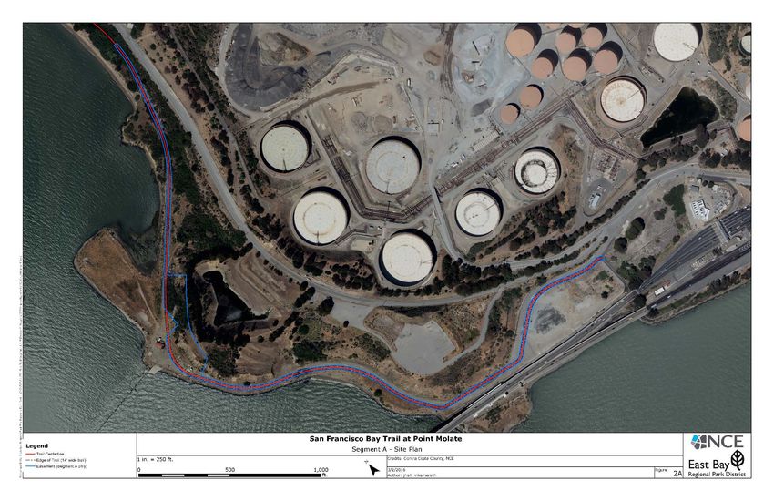
San Francisco Bay Trail at Point Molate
1.0 INTRODUCTION                          PRELIMINARY BIOLOGICAL RESOURCE ASSESSMENT
San Francisco Bay Trail at Point Molate
TABLE OF CONTENTS                                            PRELIMINARY BIOLOGICAL RESOURCE ASSESSMENT

                                            TABLE OF CONTENTS

1.0 INTRODUCTION .................................................................................................... 1
  1.1  Project Site and Study Area ............................................................................. 1
  1.2  Project Description ......................................................................................... 3
            Project Design ......................................................................................... 3
2.0 METHODS ............................................................................................................. 6
3.0 RESULTS .............................................................................................................. 7
  3.1  Soils and Topography ..................................................................................... 7
            Soils ....................................................................................................... 7
            Topography ............................................................................................. 7
            Climate................................................................................................... 7
  3.2  Habitats ........................................................................................................ 7
            Project Region ......................................................................................... 7
            Project Site and Vicinity ............................................................................ 8
  3.3  Special Status Species .................................................................................. 15
  3.4  Jurisdictional Waters .................................................................................... 27
4.0 POTENTIAL IMPACTS ........................................................................................... 28
  4.1  Local Ordinances and Regulations .................................................................. 28
            City of Richmond General Plan ................................................................. 28
            1994 City of Richmond General Plan ......................................................... 29
  4.2  San Francisco Bay Conservation and Development Commission ......................... 30
  4.3  Relevant Federal and State Laws ................................................................... 31
            California Environmental Quality Act......................................................... 31
            Threatened and Endangered Species ........................................................ 31
            Migratory Birds ...................................................................................... 32
            Birds of Prey ......................................................................................... 32
            Wetlands and Other Jurisdictional Waters ................................................. 32
  4.4  Project Specific Impacts ................................................................................ 33
            Impacts to Sensitive Habitats .................................................................. 33
            Impacts to Habitats for Rare and Endangered and Other Special Status
            Species ................................................................................................ 34
  4.5  Conclusion .................................................................................................. 35
5.0 REFERENCES ...................................................................................................... 36
APPENDIX A ................................................................................................................ 38

                                                                                                                 ii | P a g e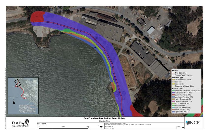
San Francisco Bay Trail at Point Molate
TABLE OF CONTENTS                                            PRELIMINARY BIOLOGICAL RESOURCE ASSESSMENT

                                               LIST OF FIGURES

Figure   1: Project Site and Vicinity ................................................................................... 2
Figure   2A: Project Site Plan ............................................................................................ 4
Figure   2B: Project Site Plan ............................................................................................ 5
Figure   3A: Habitats ..................................................................................................... 10
Figure   3B: Habitats ..................................................................................................... 11
Figure   3C: Habitats ..................................................................................................... 12
Figure   3D: Habitats ..................................................................................................... 13
Figure   3E: Habitats ..................................................................................................... 14
Figure   4: CNDDB......................................................................................................... 16

                                                LIST OF TABLES

Table 1. Soils Occurring on the Point Molate Trail Project Site ............................................ 7
Table 2. List of Special Status Species that May Occur in the Project Vicinity ..................... 17

                                                                                                                 iii | P a g e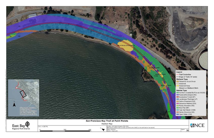
San Francisco Bay Trail at Point Molate
1.0 INTRODUCTION                               PRELIMINARY BIOLOGICAL RESOURCE ASSESSMENT

                                  1.0     INTRODUCTION

This Preliminary Biological Resource Assessment was prepared for the site of the Point Molate
Trail Project (Project). This report describes the biological resources found in the area and the
potential for impacts to those biological resources that must be considered under the California
Environmental Quality Act (CEQA). The report concludes with an analysis of those potential
impacts

The objectives of this report are to:

           •   Summarize all site-specific information related to existing biological resources;
           •   Draw reasonable conclusions about the biological resources that could occur
               onsite based on habitat suitability, historical occurrences, and the proximity of
               the site to a species’ known range;
           •   Identify and discuss the potential impacts to biological resources from the Project
               likely to occur on and near the site within the context of CEQA; and
           •   Identify avoidance and mitigation measures that would reduce potential impacts
               and that are generally consistent with recommendations of the resource agencies
               for affected biological resources.

1.1    PROJECT SITE AND STUDY AREA

The project study area is located in Contra Costa County, California (Figure 1) and includes the
City of Richmond (City) rights-of-way and portions of adjacent private parcels. The Project
overlaps or is located adjacent to portions of the following APNs: 561-040-013, 561-040-016,
561-040-015, 561-040-014, 561-040-004, 561-050-003, 561-400-004, 561-400-008, 561-
100-008, and 561-080-006. The Project site is found on portions of the San Quentin, California
7.5 minute USGS quadrangle. Photographs of the site are found in Appendix A.

The project study area covers approximately 2.3 miles of trail and a width of 200 feet, which is
approximately 55 acres. Areas of steep slopes are found along the eastern portion of the study
area.

The proposed trail footprint is much smaller than the project study area. The larger project
study area is examined to determine the potential for indirect impacts to protected habitats,
flora, and fauna.

The proposed trail footprint is relatively level and follows the shoreline; at approximately 10
feet in width plus 2 foot wide shoulders on either side. According to the City of Richmond
Zoning Map, the project study area is zoned Community and Regional Recreational (City of
Richmond, 2008).

                                                                                        1|Page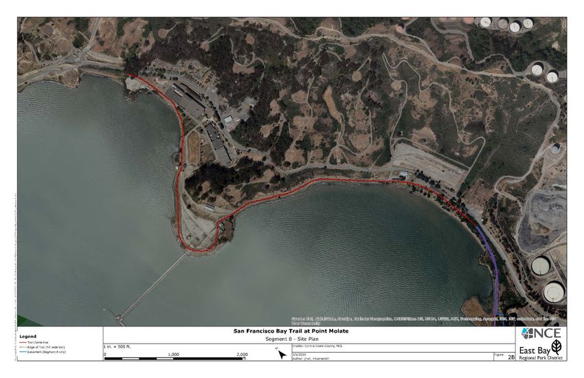
San Francisco Bay Trail at Point Molate
1.0 INTRODUCTION                          PRELIMINARY BIOLOGICAL RESOURCE ASSESSMENT

Figure 1: Project Site and Vicinity

                                                                           2|Page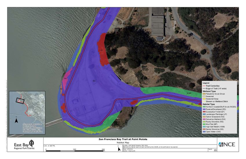
San Francisco Bay Trail at Point Molate
1.0 INTRODUCTION PRELIMINARY BIOLOGICAL RESOURCE ASSESSMENT
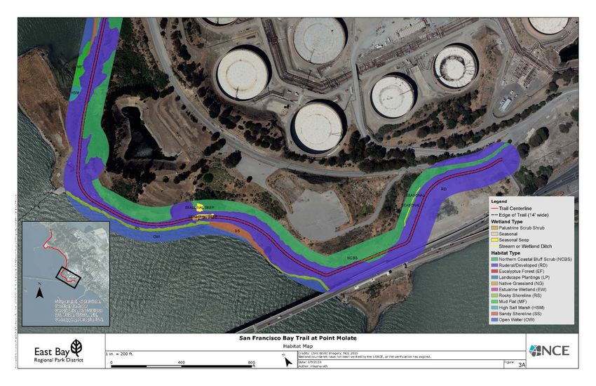
1.2 PROJECT DESCRIPTION
The San Francisco Bay Trail is anticipated to be a 500-mile shoreline path that will encircle the
Bay in the future. Currently more than 340 miles have been completed along the shoreline
through nine counties and 47 cities. The East Bay Regional Park District (EBRPD) is conducting
the engineering design documents, CEQA documents, and completion of all necessary
regulatory permits to construct the San Francisco Bay Trail (Bay Trail) at Point Molate.
The current focus of the design and environmental documents is for the development of a 1.1
mile section of non-motorized Class I trail connecting the Bay Trail from the Richmond-San
Rafael (RSR) Bridge out around Castro Point to the Point Molate Beach Park, which has been
designated as Segment A as shown on Figure 2A.
The additional trail segment that EBRPD would like to include collaboratively with the City of
Richmond is Segment B, shown on Figure 2B, which continues from Segment A at the southern
edge of the Point Molate Park then extends through the park and continues north along Burma
Road to the former Point Molate Treatment Pond area.
Project Design
The general approach to the design of the trail is to locate the footprint within the existing
railroad alignment to minimize grading, using land that has already been developed to the
extent practicable. The current design also allows for minimizing grading by using existing
paved surfaces and old railroad ballasts for trail support. This will not only reduce grading costs
but reduce construction exposure and more expensive handling and off-haul of potentially
contaminated soils. The other advantage of working in the existing railroad alignment is railroad
tracks are sited on “better ground” and provide good support for the future trail. Utilizing a
previously impacted footprint for the trail will reduce the impact to sensitive resources and avoid
most sensitive habitats.
EBRPD plans to use common and readily obtainable trail building materials that are cost
effective, low maintenance, and easily procured by a contractor. The trail surface will be paved
and the shoulders will be gravel or crushed rock.
Another key consideration is how the contractor will gain access to the site and where the
contractor can store materials and equipment. The access for Segment A from the south end
where the trail starts includes a parking lot which would promote a logical construction staging
area. Segment B would have construction access via either Point Molate Beach Park or the
former Point Molate Treatment Pond area.
3|Page
San Francisco Bay Trail at Point Molate
1.0 INTRODUCTION                          PRELIMINARY BIOLOGICAL RESOURCE ASSESSMENT

Figure 2A: Project Site Plan

                                                                           4|Page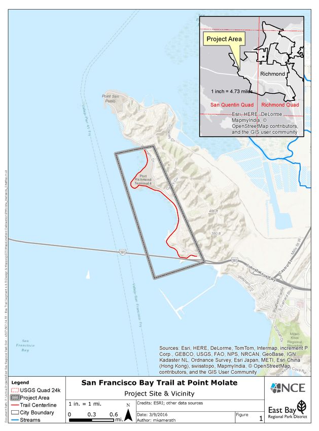
San Francisco Bay Trail at Point Molate
1.0 INTRODUCTION                          PRELIMINARY BIOLOGICAL RESOURCE ASSESSMENT

Figure 2B: Project Site Plan

                                                                           5|Page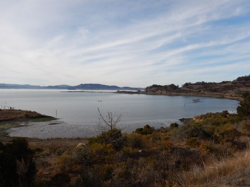
San Francisco Bay Trail at Point Molate
2.0 METHODS                                    PRELIMINARY BIOLOGICAL RESOURCE ASSESSMENT

                                     2.0     METHODS

The purpose of this Preliminary Biological Resource Assessment is to describe the biological
resources found in the area and the potential for impacts to those biological resources that must
be considered under CEQA. Research was conducted on biological resources known to occur in
the area and a site visit included both a reconnaissance level survey and a survey and mapping
of the waters of the U.S. (WOUS) found on the site.

Site specific references and background information reviewed include:

       •   Analytical Environmental Services, 2009. Point Molate Mixed-use Tribal Destination
           Resort and Casino Project DEIS/DEIR.
       •   California Natural Diversity Database (CNDDB). 2015. California Department of Fish
           and Game, Sacramento, CA. Accessed online.
       •   California Native Plant Society. 2015. Inventory of Rare and Endangered Vascular
           Plants of California (online edition, v8-01a). Accessed online.
       •   LSA, 2011. Natural/Cultural Resource Information, Point Molate Bay Trail. Technical
           memorandum to EBRPD.
       •   LSA, 2011.       Wetland delineation Study, Point Molate Bay Trail. Technical
           memorandum to EBRPD.
       •   Natural Resource Conservation Service. United States Department of Agriculture.
           Web Soil Survey. Accessed online.
       •   Tetra Tech, Inc., 1998. Special Status Plant Survey and Habitat Assessment. Navy
           Fuel Depot, Point Molate, Contra Costa County, California.
       •   U.S.G.S. San Quentin, California (1995) 7.5 minute quadrangle.
       •   U.S. Fish and Wildlife Service. 2015. Federally Endangered and Threatened Species
           that Occur in or may be Affected by Projects in the San Quentin U.S.G.S. 7 ½ Minute
           Quad. Accessed online.

The site was visited on October 26th, 27th, and 28th, 2015 by NCE scientists Mack Casterman,
Marcy Kamerath and John Heal. A reconnaissance level survey was conducted, plant
communities and habitats were observed and recorded, and the edges of the Ordinary High
Water Mark (OHWM) and riparian area were delineated and subsequently mapped and
previously mapped wetlands were confirmed. Transects were traversed on foot and the site
was photographed. Focused surveys for special status species of flora and fauna were not
conducted.

                                                                                       6|Page
San Francisco Bay Trail at Point Molate
3.0 RESULTS PRELIMINARY BIOLOGICAL RESOURCE ASSESSMENT
3.0 RESULTS
3.1 SOILS AND TOPOGRAPHY
Soils
According to the Natural Resources Conservation Service, soils found in the immediate vicinity
of the project site are Millsholm loam, 20% to 60% slopes, Quarry, and Urban land (NRCS
2016). This soil unit is not known to contain serpentine (University of California, 2009). A
summary of this soil unit is found in Table 1 below.
Table 1. Soils Occurring on the Point Molate Trail Project Site
% of
Map Drainage
Soil Series/Soil Parent Material project
Symbol class
boundary
Millsholm loam, 20 to 60 percent Very steep shallow
MeG well drained 79%
slopes, moist, MLRA 15 fine loam
Depressions without
Quarry Qa 4%
soil
Generally pavement
Urban land Ub 17%
and buildings
Source: NRCS 2011
Topography
Topography in the vicinity of the site ranges from rolling to steep. Elevations of the project site
range from approximately 0 feet to 150 feet (0 meters to 45 meters) above mean sea level.
Climate
The climate in Contra Costa County (CCC) varies depending on the location and topography.
Western CCC experiences cool summers and mild winters due to its proximity to San Francisco
and San Pablo Bays. On the other hand, eastern CCC, which includes portions of the San
Joaquin Valley, has hot and dry summers with cool winters. Elevation and proximity to the sea
have a direct affect on the average annual precipitation across the County. Antioch, which is
located near sea level, receives 13.34 inches, while the north gate at Mt. Diablo (elevation 344
feet) receives 22.77 inches and Richmond in western CCC receives 22.28 inches. While most
precipitation falls in the form of rain across the County, higher elevation areas including Mt.
Diablo and its surrounding foothills will receive snow during the winter months (NRCS 1977).
3.2 HABITATS
Project Region
The lands surrounding the site are on the coast are influenced by immediate proximity to the
coast. Habitats in this area include eucalyptus forest, ruderal, northern coastal bluff scrub,
native grassland, urban landscapes, high salt marsh, estuaries, tideflats, rocky and sandy
intertidal zones, and the nearshore environment. Other habitats in the region include wetlands,
ponds, riparian areas, and streams.
7|PageSan Francisco Bay Trail at Point Molate
3.0 RESULTS PRELIMINARY BIOLOGICAL RESOURCE ASSESSMENT
Project Site and Vicinity
Fourteen general habitat types were identified on the project study area (Figures 3A – 3E).
These habitat types are based on their potential to support Special Status Species (SSS) flora
and fauna. The habitat types are palustrine scrub-shrub, seasonal and seasonal seep wetlands,
northern coastal bluff scrub, ruderal/developed, eucalyptus forest, landscaped, native
grassland, estuarine wetland, rocky shoreline, mud flat, high salt marsh, sandy shoreline and
open water. Photographs of the site are found in Appendix A.
Northern Coastal Bluff Scrub: Plants in the scrub community are characterized by flexible
woody stems and soft leaves. At Pt. Molate, the scrub is adapted to cool conditions that are
influenced by the maritime fog. The community at Pt. Molate has been classified as Northern
Coastal Bluff Scrub – a rare type of coastal scrub that is classified by the California Department
of Fish and Wildlife as a “Sensitive Natural Community” (G2.S2.2). Characteristic of its type,
this community intergrades with native grassland at Pt. Molate. Species in the northern coastal
bluff scrub community include: coyote brush (Baccharis pilularis), toyon (Heteromeles
arbutifolia), coast buckwheat (Erigonium latifolium), coastal sagebrush (Artemisia californica),
live oak (Quercus agrifolia), coffeeberry (Rhamnus californica), California buckeye (Aesculus
californica), and snowberry (Symphoricarpos albus).
Eucalyptus Forest: This habitat type is invading coastal scrub and native grassland areas on
the project site. Eucalyptus forest habitat is dominated by blue gum (Eucalyptus globulus);
poison oak (Toxicodendron diversilobum), and toyon occur in the periphery.
Native Grassland: The native grassland at Pt. Molate is characterized by open areas of native
bunchgrass and native forbs. These grassland areas include Purple Needlegrass and California
Oatgrass alliances with either Stipa pulchra or Danthonia californica as the dominant species.
According to the Manual of California Vegetation, purple needlegrass need only make up 5% of
absolute cover, or 10% of relative cover to qualify as this alliance.
Together, these alliances make up a “coastal terrace prairie” community which is identified by
a maritime (fog) influence and a cooler climate than grasslands in areas farther inland. This
community type is rare throughout coastal regions of the State, but particularly in the East Bay
where shoreline development has destroyed all but a few remnant stands such as the one at
Pt. Molate. The California Department of Fish and Wildlife classifies this community as a
“sensitive natural community” (G2.S2.1). Other species of note in the native grassland
community at Pt. Molate include Molate fescue (Festuca rubra ‘molate’), a unique ecotype that
has gained widespread use in the nursery trade and is believed to have originated at Pt. Molate.
In the absence of grazing and fire, certain native grassland areas at Pt. Molate are in the process
of being converted to coastal scrub and other areas are being invaded by invasives such as
French broom (Genista monspesullana).
Landscape plantings: Established plants and trees that were planted as part of beach park
landscaping. Species include Monterey pine (Pinus radiata), eucalyptus (Eucalyptus sp.), and
acacia (Acacia sp.).
Palustrine Shrub Scrub Wetland: freshwater wetland areas which lack flowing water and
may contain ocean derived salts due to proximity to shoreline. Dominated by shrub species
such as red willow (Salix laevigata) and arroyo willow (Salix lasiolepsis).
8|PageSan Francisco Bay Trail at Point Molate
3.0 RESULTS PRELIMINARY BIOLOGICAL RESOURCE ASSESSMENT
Freshwater Wetland: wetland areas that are only influenced by freshwater saturation,
dominated by rushes (Juncus effusus and Juncus patens), Italian ryegrass (Lolium multiflorum)
and meadow barley (Hordeum branchyantherum).
Estuarine wetland: A wetland habitat type characterized by being partially enclosed by land
but with open or sporadic access to ocean water which is diluted by freshwater runoff from land.
Estuarine wetlands are typically dominated by California cordgrass (Spartina foliosa). High salt
marsh is dominated by pickelweed (Salicornia virginica), marsh gumplant (Grindelia stricta),
and saltgrass (Distichlis spicata).
Rocky shoreline: mostly adjacent to ruderal areas. Rocks are largely anthropic in origin.
Sandy shoreline: shoreline with much salt water and tidal influence characterized by deep
sand.
High salt marsh: A coastal habitat type found in the upper tidal zone between land and open
salt water that is regularly flooded by tides.
Mud flat: A habitat characterized by open muddy land that is left uncovered at low tide.
Rocky shorelines and mud flats are generally unvegetated. Sandy shorelines are also
unvegetated and open water may include eelgrass beds (Zostera marina).
Ruderal/Developed: previously developed areas that still exhibit the impacts of development
- often characterized by pavement or heavily compacted soil. Plants are mostly non-native
invasive with few native species present. These include ripgut brome (Bromus diandrus), Italian
ryegrass, Italian thistle (Carduus pyncnocephalus), field mustard (Brassica rapa), sticky
tarweed (Holocarpha virgata), wild radish (Raphanus sativus), bristly ox-tongue (Picris
echioides), artichoke thistle (Cynara cardunculus), and winter vetch (Vicia villosa).
Non-native plants that are invasive on the site include French broom, pampas grass (Cortaderia
jubata), and ice plant (Carpobrotus edulis x chilensi), a non-native found on the beach south of
Point Molate Park. Multiple invasive exotics listed by the California Invasive Plant Council (Cal-
IPC) as species of ‘High’ concern were found on the site. These are Himalayan blackberry
(Rubus discolor), French broom, and fennel (Foeniculum vulgare).
Wildlife Habitats. The habitats within and surrounding the project site support a varied
assemblage of wildlife, which may move through the region or migrate seasonally. Intact or
partially intact native grassland, high salt marsh, and willow scrub-shrub wetlands are
increasingly scarce in the Bay area, and therefore crucially important to native wildlife.
Many shoreline habitats along San Francisco and San Pablo Bay are bisected by road and
railroad. The railroad bed at Point Molate is no longer active; in fact, it is the location of the
proposed trail. In addition, there are no through roads and traffic is limited. Because of this
lower disturbance regime, the habitats along this trail corridor are particularly important for
wildlife.
The proximity of habitat types provide habitat for a number of resident and migratory birds and
makes the area particularly rich in avian fauna. Pelagic birds, shorebirds, waterfowl, passerines,
raptors and others can be found in the vicinity from time to time. These and other birds may
nest, forage, or winter in habitats on or adjacent to the site. The shoreline, wetland and upland
habitats in the vicinity also provide foraging and cover for several mammal species. These
include coyote (Canis latrans) and mule deer (Odocoileus hemionus).
9|PageSan Francisco Bay Trail at Point Molate
3.0 RESULTS PRELIMINARY BIOLOGICAL RESOURCE ASSESSMENT
Figure 3A: Habitats
10 | P a g eSan Francisco Bay Trail at Point Molate
3.0 RESULTS PRELIMINARY BIOLOGICAL RESOURCE ASSESSMENT
Figure 3B: Habitats
11 | P a g eSan Francisco Bay Trail at Point Molate
3.0 RESULTS PRELIMINARY BIOLOGICAL RESOURCE ASSESSMENT
Figure 3C: Habitats
12 | P a g eSan Francisco Bay Trail at Point Molate
3.0 RESULTS PRELIMINARY BIOLOGICAL RESOURCE ASSESSMENT
Figure 3D: Habitats
13 | P a g eSan Francisco Bay Trail at Point Molate
3.0 RESULTS PRELIMINARY BIOLOGICAL RESOURCE ASSESSMENT
Figure 3E: Habitats
14 | P a g eSan Francisco Bay Trail at Point Molate
3.0 RESULTS PRELIMINARY BIOLOGICAL RESOURCE ASSESSMENT
3.3 SPECIAL STATUS SPECIES
A wide variety of taxa native to the state of California have low populations, limited
distributions, or are otherwise vulnerable to extinction or extirpation with the state. Although
they may include Ecologically Significant Units and sub-species as well as species, these taxa
are collectively referred to as “special status species” (SSS).
These flora and fauna may be considered “rare” and are vulnerable to extirpation as the state’s
human population grows, the habitats these species occupy are converted to agricultural and
urban uses, and they are subject to other impacts, such as climate change or wildfires. State
and federal laws have provided the California Department of Fish and Wildlife (CDFW) and the
U.S. Fish and Wildlife Service (USFWS) with the responsibility for conserving and protecting the
diversity of plant and animal species native to the state. Because of the diversity of habitats
within the state, a relatively large number of native plants and animals have been formally
designated as “threatened” or “endangered” under state and federal endangered species
legislation. Others have been designated as candidates for such listing. Still others have been
designated as “species of special concern” by the CDFW. The California Native Plant Society
(CNPS) has developed its own set of lists of native plants considered rare, threatened, or
endangered (CNPS 2010). Additionally, conservation groups such as the American Fisheries
Society, the World Conservation Union, and the Xerces Society have developed lists and
categorized species that are of particular concern with regard to conservation.
A number of special status plants and animals have the potential to occur in the site’s vicinity
(Figure 4). These species and the likelihood of their occurrence in the study area are listed in
Table 2, found below. Sources of information for this table included California’s Wildlife,
Volumes I, II, and III (Zeiner et. al 1988), California Natural Diversity Database (CDFG 2011),
California Wildlife Habitat Relationships (CDFG 2008a), National Marine Fisheries Service (NOAA
2011), A California Cooperative Anadromous Fish and Habitat Data Program (CalFish 2011),
and The California Native Plant Society’s Inventory of Rare and Endangered Vascular Plants of
California (CNPS 2010). This information was used to evaluate the potential for special status
plant and animal species to occur on the site. It is important to note that the California Natural
Diversity Database is a volunteer database of historical occurrences; therefore, it may not
contain all known or gray literature records.
In addition to the CNDDB, biological studies previously conducted in the vicinity were reviewed
and determinations made regarding the likelihood of SSS to occur on the site or in nearby
habitats. A list of federally protected species was generated for the San Quentin quadrangle
by the USFWS and retrieved by NCE, and these species were also reviewed for their potential
to occur on the site. The results are presented in Table 2.
15 | P a g eSan Francisco Bay Trail at Point Molate
3.0 RESULTS PRELIMINARY BIOLOGICAL RESOURCE ASSESSMENT
Figure 4: CNDDB
16 | P a g eSan Francisco Bay Trail at Point Molate
3.0 RESULTS PRELIMINARY BIOLOGICAL RESOURCE ASSESSMENT
Table 2. List of Special Status Species that May Occur in the Project Vicinity
Species Status Habitat Occurrence in the study area
Plant Species
Coastal prairie, coastal
Santa Cruz Unlikely. Species distribution
FT, CE, scrub, and valley and
tarplant limited to specific areas.
CNPS foothill grassland. 10 -
(Holocarpha Potential habitat does not exist
1B.1 220 meters. Blooms
macradenia) on site.
June - October.
Bent-flowered Coastal bluff scrub,
Possibly. Suitable habitat
fiddleneck 1B.2 cismontane woodlands,
occurs on or near the site.
(Amsinckia lunaris) grasslands.
Alkali milk-vetch Valley grassland, alkali Possibly. Alkali pool at north
(Astragalus tener 1B.2 sink, freshwater end of segment 2 is potential
var. tener) wetlands. habitat.
Point Reyes birds-
Unlikely. Alkali pool and salt
beak
Coastal salt marsh, marsh could support this
(Cordylanthus 1B.2
wetland riparian. species. Assumed extirpated
maritimus ssp.
from the East Bay.
palutris)
Unlikely. Alkali pool and salt
Soft birds-beak
Coastal salt marsh, marsh could support this
(Cordylanthus 1B.2
wetland riparian. species. Reported from Point
mollis ssp. mollis)
Pinole.
Usually serpentinite,
mesic habitats including
Unlikely. Species distribution
chaparral, cismontane
Loma Prieta hoita limited to specific areas.
1B.1 woodland, and riparian
(Hoita strobilina) Potential habitat does not exist
woodland. 30 - 860
on site.
meters. Blooms May -
October.
Marsh gumplant
Likely. Was observed near the
(Grindelia stricta CNPS 4 Coastal salt marshes.
site in 1998 (Tetra Tech, 1998).
var. angustifolia)
Marshes and swamps
California seablite
FE, CNPS (coastal salt). 0 - 15 Absent. No records form
(Suaeda
1B.1 meters. Blooms July - Contra Costa County.
californica)
October.
Marin Dwarf-flax
FT, CNPS Unlikely. Species distribution
(Hesperolinon Serpentine endemic.
1B.1 limited to specific areas.
congestum)
17 | P a g eSan Francisco Bay Trail at Point Molate
3.0 RESULTS PRELIMINARY BIOLOGICAL RESOURCE ASSESSMENT
Species Status Habitat Occurrence in the study area
Showy Indian
FE, CNPS Valley grassland, Absent. No records from
Clover (Trifolium
1B.1 riparian. Contra Costa County.
amoenum)
Tiburon
Jewelflower FE, CNPS Unlikely. Species distribution
Serpentine endemic.
(Streptanthus 1B.1 limited to specific areas.
niger)
Tiburon Mariposa
Lily FT, CNPS Unlikely. Species distribution
Serpentine endemic.
(Calochortus 1B.1 limited to specific areas.
tiburonensis)
Tiburon Paintbrush
FE, CNPS Unlikely. Species distribution
(Castilleja affinis Serpentine endemic.
1B.2 limited to specific areas.
ssp. Neglecta)
White-rayed
Pentachaeta FE, CNPS Valley grassland. Unlikely. Species distribution
(Pentachaeta 1B.1 Affinity for serpentine. limited to specific areas.
bellidiflora)
Suisun marsh
Likely. Historic record from the
aster Freshwater wetlands,
1B.2 adjacent fuel depot site (AES,
(Symphyotrichum brackish marsh.
2009).
lentum)
Present. Observed on sandy
Beach bur
shoreline south of Point Molate
(Ambrosia A2 Coastal habitat.
Beach Park. Considered rare by
chamissonis)
Dianne Lake.
Avian Species
Allen’s
Coast chaparral,
hummingbird Possible. May occur seasonally
BCC brushland, and edges of
(Selasphorus on or near the site.
redwood forest.
sasin)
California Endemic.
Year-round range
confined to tidal and
San Pablo song muted tidal salt marshes
Possible. Potential nesting
sparrow (Melospiza CSC, BCC fringing San Pablo Bay.
habitat does exist near site.
melodia samuelis) Dense vegetation is
required for nesting
sites, song perches, and
as cover from predators.
18 | P a g eSan Francisco Bay Trail at Point Molate
3.0 RESULTS PRELIMINARY BIOLOGICAL RESOURCE ASSESSMENT
Species Status Habitat Occurrence in the study area
Most common in tidal
emergent wetlands
dominated by
CT, FP, pickleweed (Salicornia
California black rail Possible. Potential nesting
ABC sp.) or brackish marshes
(Laterallus habitat does not exist on site.
WLBCC, supporting bulrush
jamaicensis Dispersing birds could use
IUCN NT, (Scirpus sp.). Nesting
coturniculus) adjacent salt marsh habitats.
BCC occurs March-June in
dense vegetation near
upper limits of tidal
flooding.
Osprey Present. Observed on site. At
Nests near large bodies
(Pandion CSC least one nest is located near the
of water with fish.
haliaetus) proposed trail route.
Requires emergent
wetlands and tidal
sloughs, although
occasionally uses
transition zone between
California clapper wetland and adjacent Possible. Potential nesting
FE, CE,
rail (Rallus upland habitat. Nesting habitat does not exist on site.
FP, ABC
longirostris occurs mid-March to July Dispersing birds could use
WLBCC
obsoletus) in lower zones of saline adjacent salt marsh habitats.
emergent wetlands,
where cordgrass
(Spartina sp.) is
abundant and tidal
sloughs are nearby.
Can be found on sandy
beaches, sand spits,
dune-backed beaches,
sparsely-vegetated Possible. Beaches in project
Western snowy FT, CSC,
dunes, beaches at creek vicinity are too small to allow
plover (Charadrius ABC
and river mouths, and nesting, but birds may
alexandrinus WLBCC,
salt pans at lagoons and occasionally forage in these
nivosus) BCC
estuaries. Breeding habitats.
occurs March-September
in shallow scrapes or
depressions in the sand.
19 | P a g eSan Francisco Bay Trail at Point Molate
3.0 RESULTS PRELIMINARY BIOLOGICAL RESOURCE ASSESSMENT
Species Status Habitat Occurrence in the study area
Frequents estuarine,
marine subtidal, and
F
California brown marine pelagic waters.
Delisted-
pelican (Pelecanus Breeds March - August Present. Observed near the
2009, C
occidentalis on Channel Islands site.
Delisted
californicus) (Anacapa, Santa
2009, FP
Barbara, and Santa
Cruz).
Migratory. Feeds in
shallow estuaries or
lagoons where small fish
are abundant. Breeds in
California least FE, SE, abandoned salt ponds Unlikely. Does not occur on the
tern (Sternula FP, ABC and along estuarine site. May forage in shallow near
antillarum browni) WLBCC, shores in San Francisco shore waters during summer.
Bay. Breeding occurs in
areas free of human or
predatory disturbance
from April-August.
Individuals breed on
Unlikely. Peregrine falcon may
cliffs in the Sierra or in
Peregrine falcon occur incidentally on the site if
coastal habitats; occurs
(Falco peregrinus CE they forage over adjacent areas.
in many habitats of the
anatum) Suitable nesting habitat is
state during migration
absent from the site.
and winter.
Possible. This species may
Short-eared owl Open country and occur incidentally on the site, or
BCC
(Asio flammeus) grasslands. may nest in grassland on or near
the site.
Black-vented Usually within a few Unlikely. May occur incidentally
shearwater miles of shore during off shore near the site. Suitable
BCC
(Puffinus winter. Breeds in nesting habitat is absent from
opisthomelas) Mexico. the site.
Very arid regions where
there is some minor Possible. This species may
Costa's
brush or scrub cover. In occur incidentally on the site, or
hummingbird BCC
summer the breeding may nest in shrubs on or near
(Calypte costae)
range extends into the site.
California.
Possible. This species may
Thickets and edges of
Fox sparrow occur incidentally on the site, or
BCC forests or chaparral.
(Passerella iliaca) may nest in shrubs on or near
Nests near the ground.
the site.
Nesting habitat is dry
Lawrence's Possible. This species may
and open woods that are
goldfinch occur incidentally on the site, or
BCC near both brushy areas
(Carduelis may nest in shrubs on or near
and fields of tall annual
lawrencei) the site.
weeds.
20 | P a g eSan Francisco Bay Trail at Point Molate
3.0 RESULTS PRELIMINARY BIOLOGICAL RESOURCE ASSESSMENT
Species Status Habitat Occurrence in the study area
Nests in large marshes
with dense vegetation.
Unlikely. May occur incidentally
Least Bittern The nest is a well-
BCC near the site. Suitable nesting
(Ixobrychus exilis) concealed platform built
habitat is absent from the site.
from cattails and other
marsh vegetation.
Coastal mudflats and Unlikely. May occur near the
Lesser yellowlegs
BCC flooded fields during site in winter. Suitable nesting
(Tringa flavipes)
winter. habitat is absent from the site.
Lewis's
Mixed oak woodland, Unlikely. May occur on or near
woodpecker BCC
ponderosa pine. the site in winter.
(Melanerpes lewis)
The bird requires an
open habitat with an
Loggerhead shrike
area to forage, elevated Possible. May occur on the site
(Lanius BCC
perches and nesting in winter.
ludovicianus)
sites. Prefers shorter
vegetation.
Long-billed curlew Mudflats, salt marshes,
Unlikely. May occur on or near
(Numenius BCC beaches; breeds in
the site in winter.
americanus) grasslands.
Mudflats, salt marshes,
Marbled godwit Unlikely. May occur on or near
BCC beaches; breeds in
(Limosa fedoa) the site in winter.
grasslands.
Possible. This species may
Nuttall's
Oak woodland, riparian occur incidentally on the site, or
woodpecker BCC
habitat, and chaparral. may nest in trees on or near the
(Picoides nuttallii)
site.
Oak titmouse
Open mixed oak Unlikely. Suitable habitat does
(Baeolophus BCC
woodlands. not exist on the site.
inornatus)
Possible. This species may
Olive-sided
Coniferous and occur incidentally on the site, or
flycatcher BCC
eucalyptus woodlands. may nest in trees on or near the
(Contopus cooperi)
site.
This species is pelagic,
Pink-footed
occurring in the Pacific
shearwater Unlikely. Suitable habitat does
BCC Ocean. It predominantly
(Puffinus not exist on the site.
nests on offshore islands
creatopus)
off Chile.
Short-billed Mudflats, salt marshes,
dowitcher beaches; breeds in bogs, Unlikely. May occur on or near
BCC
(Limnodromus tidal marshes, and the site in winter.
griseus) forests.
Wet meadows, fens, and
Yellow rail
shallow marshes. May Possible. May occur on the
(Coturnicops BCC
winter on the California site.
noveboracensis)
coast.
21 | P a g eSan Francisco Bay Trail at Point Molate
3.0 RESULTS PRELIMINARY BIOLOGICAL RESOURCE ASSESSMENT
Species Status Habitat Occurrence in the study area
Yellow warbler
Riparian trees and
(Dendroica Possible. May occur on the
BCC shrubs, particularly
petechia ssp. site.
willow.
Brewsteri)
Red knot (Calidris Mudflats, salt marshes,
Unlikely. May occur on or near
canutus ssp. BCC beaches; breeds in
the site in winter.
Roselaari) tundra.
Open country, prairies,
Burrowing owl deserts, fallow fields,
Unlikely. Suitable habitat does
(Athene BCC coastal dunes with
not exist on the site.
cunicularia) mammal burrows and
friable soils.
Open and semi-open Possible. Swainson’s hawk
country – deserts, may occur incidentally on the
Swainson's hawk
BCC grasslands and prairies. site if they forage over adjacent
(Buteo swainsoni)
Nests in isolated or areas. They are unlikely to nest
riparian trees. on the site.
Open grasslands, Possible. Northern harrier may
marshes, and riparian occur incidentally on the site if
Northern harrier
CSC woodlands. Nests in they forage over adjacent areas.
(Circus cyaneus)
undisturbed open field or Suitable nesting habitat is
meadow. absent from the site.
Meadows, rangeland;
Tricolored
nests in large emergent Unlikely. Suitable habitat does
blackbird (Agelaius BCC, CSC
marshes, especially not exist on the site.
tricolor)
cattails.
Whimbrel Mudflats, salt marshes,
Unlikely. May occur on or near
(Numenius BCC beaches; breeds in
the site in winter.
phaeopus) tundra.
Possible. Bald eagles may
Bald eagle Near seacoasts, large occur incidentally on the site if
BCC,
(Haliaeetus lakes, and rivers where they forage over adjacent areas.
BEPA
leucocephalus) fish are present. They are unlikely to nest on the
site.
Black Intertidal zone of rocky
oystercatcher shorelines. Nests in
BCC Present. Observed on site.
(Haematopus pebble or scrape on the
bachmani) beach.
Possible. This species may
Bell’s sparrow Sagebrush, chaparral, occur incidentally on the site, or
BCC
(Amphispiza belli) dry foothills. may nest in shrubs on or near
the site.
Bryant’s savannah Coastal marsh and
sparrow grassland. High salt
Possible. This species may
(Passerculus marsh and adjacent
CSC occur incidentally on the site, or
sandwichensis uplands. Nest on or
may nest on or near the site.
alaudinus) near the ground in
herbaceous vegetation.
22 | P a g eSan Francisco Bay Trail at Point Molate
3.0 RESULTS PRELIMINARY BIOLOGICAL RESOURCE ASSESSMENT
Species Status Habitat Occurrence in the study area
Saltmarsh
Possible. This species may
common Breeds in forested
occur on or near the site, or may
yellowthroat CSC wetlands, brackish and
nest in willow thickets on the
(Geothlypis trichas freshwater marshes.
site.
sinuosa)
Mammal Species
San Pablo vole
Salt marshes adjacent to Unlikely. Potential salt marsh
(Microtus
CSC southeastern part of San habitat is marginally large
californicus
Pablo bay. enough.
snpabloensis)
Salt-marsh
Unlikely. Potential salt marsh
vagrant shrew High salt marsh;
CSC habitat is marginally large
(Sorex vagrans Salicornia.
enough.
halicoetes)
Found only in saline
emergent wetlands of
San Francisco Bay and
its tributaries.
Salt-marsh harvest Pickleweed saline
FE, CE, Unlikely. Potential salt marsh
mouse emergent wetlands are
FP, IUCN habitat is marginally large
(Reithrodontomys preferred, while adjacent
EN enough.
raviventris) grasslands may also be
used. Nests in grass and
sedges, not burrows.
Breeding occurs March -
November.
Herptile Species
A pond frog that inhabits
humid forests,
woodlands, grasslands,
Unlikely. Suitable habitat for
and streamsides;
this species is present in the
California red- however, frequents
FT, CSC, general vicinity. No permanent
legged frog (Rana otherwise permanent
IUCN VU sources of water are found on
draytonii) sources of water.
the site, which is generally dry
Breeds January-April and
and faces southwest.
can be found in damp
woods during non-
breeding periods.
23 | P a g eSan Francisco Bay Trail at Point Molate
3.0 RESULTS PRELIMINARY BIOLOGICAL RESOURCE ASSESSMENT
Species Status Habitat Occurrence in the study area
Fish Species
Require cool freshwater
for spawning and rearing
sites. Adult runs occur
during the winter, while
the amount of time
Central California
spent in fresh versus salt Absent. Does not occur on the
coast steelhead FT, AFS
water varies site. May be present in near
(Oncorhynchus TH
considerably. Typically shore waters.
mykiss)
steelhead enter the
streams and rivers
between late December-
April, while spawning
occurs in late spring.
Delta smelt Estuary of Sacramento
(Hypomesus FT River. Brackish and Absent. Habitat not present.
transpacificus) fresh water.
Green sturgeon
Estuary of Sacramento
(Acipenser
FT River. Brackish and Absent. Habitat not present.
medirostris)
marine water.
Lagoons formed by
Tidewater goby streams running into the
(Eucyclogobius FE sea. The tidewater goby Absent. Habitat not present.
newberryi) prefers salinities of less
than 10 ppt.
Invertebrate Species
Distribution and
reproduction dependent
upon milkweed plant
Sensitive (Asclepiadaceae sp.).
species Species is a migrant of a
Monarch butterfly
under population that spends
(Danaus Present. Observed on site.
Richmond its summers in the
plexippus)
General eastern Rocky Mountains
Plan and winters in California
as far north as
Monterey, CA, in
eucalyptus trees.
Habitat
Present. Wetlands were
Wetlands
identified on the project site.
Present. Numerous native tree
Native trees species were observed within
and adjacent to the project site.
Present. Native grassland is
Native grassland present on and in the vicinity of
the project site.
24 | P a g eSan Francisco Bay Trail at Point Molate
3.0 RESULTS PRELIMINARY BIOLOGICAL RESOURCE ASSESSMENT
Species Status Habitat Occurrence in the study area
Absent. No designated Critical
Critical Habitats
Habitats are located on site.
Sources: CNDDB 2015, AES 2009, USFWS 2015, LSA 2011, Tetra Tech 1998, and CNPS 2010.
Present: Species observed on the sites at time of field surveys or during recent past.
Likely: Species not observed on the site, but it may reasonably be expected to occur there on a
regular basis.
Possible: Species not observed on the sites, but it could occur there from time to time.
Unlikely: Species not observed on the sites, and would not be expected to occur there except,
perhaps, as a transient.
Absent: Species not observed on the sites, and precluded from occurring there because habitat
requirements not met.
STATUS CODES
Federally Endangered FE
Federally Threatened FT
Federally Endangered (Proposed) FPE
Federal Candidate FC
Bald Eagle Protection Act BEPA
California Endangered CE
California Threatened CT
California Rare CR
California Protected CP
California Species of Special Concern CSC
California Watch List WL
California Fully Protected FP
USFWS Birds of Conservation Concern BCC
California Native Plant Society Listing CNPS
Plants Presumed Extinct in California 1A
Plants Rare, Threatened, or Endangered in
California and elsewhere 1B
Plants Rare, Threatened, or Endangered in
California, but more common elsewhere 2
Plants about which we need more information
– a review list 3
Plants of limited distribution – a watch list 4
25 | P a g eSan Francisco Bay Trail at Point Molate
3.0 RESULTS PRELIMINARY BIOLOGICAL RESOURCE ASSESSMENT
American Fisheries Society AFS
Endangered EN
Threatened TH
Vulnerable VU
The World Conservation Union IUCN
Conservation Dependent CD
Critically Endangered CE
Data Deficient DD
Endangered EN
Least Concern LC
Near Threatened NT
Vulnerable VU
Xerces Society: Red List Xerces
Possibly Extinct PE
Critically Imperiled CI
Imperiled IM
Vulnerable VU
Data Deficient DD
26 | P a g eSan Francisco Bay Trail at Point Molate
3.0 RESULTS PRELIMINARY BIOLOGICAL RESOURCE ASSESSMENT
3.4 JURISDICTIONAL WATERS
Jurisdictional waters are defined by the laws that protect them, including the federal Clean
Water Act (CWA) and the California Fish and Game Code, Sections 1601 through 1603 (Section
1600). The CWA regulates waters of the U.S., which typically includes rivers, creeks, and
drainages that have a defined bed and bank and which, at the very least, carry ephemeral
flows. Waters of the U.S. may also include lakes, ponds, reservoirs, and wetlands, if these
waters have a significant nexus with a Traditional Navigable Water.
Creeks, rivers, lakes, and their associated riparian areas may be subject to regulation by the
CDFW under Section 1600, and the California Regional Water Quality Control Board (RWQCB)
may take jurisdiction over all waters of the state. Waters of the state are defined as all surface
and groundwater within the state of California. San Pablo Bay and its associated wetlands are
waters of the U.S., as are other wetlands located on the site.
27 | P a g eSan Francisco Bay Trail at Point Molate PRELIMINARY BIOLOGICAL RESOURCE ASSESSMENT
4.0 POTENTIAL IMPACTS
4.0 POTENTIAL IMPACTS
4.1 LOCAL ORDINANCES AND REGULATIONS
Local ordinances and regulations of importance include the City of Richmond General Plans (City
of Richmond 1994 and 2011). These plans discuss trees and general habitat areas that should
be protected. These include significant trees, native trees, heritage trees, oak woodlands,
wetlands, marshlands, baylands, creek corridors, riparian areas, and habitats which are unique
or rare. Existing oak, willow or California buckeye trees (Quercus spp., Salix spp., or Aesculus
californica) and coyote bush shrubs (Baccharis pilularis) should be protected from all
construction activities.
City of Richmond General Plan
The project will require compliance with any element of the City’s 1994 and 2011 General Plans
which protects sensitive natural resources (e.g., conservation, open space, etc.) (City of
Richmond 1994 and 2011). These specific policies include:
City of Richmond 2011 General Plan
Policy CN1.1 Habitat and Biological Resources Protection and Restoration
• Natural habitat is essential to ensuring biodiversity and protecting sensitive
biological resources. Protect these areas and work with the California Department
of Fish and Game, the San Francisco Bay Regional Water Quality Control Board,
the East Bay Regional Park District, and other regional agencies to identify areas
for special protection and establish appropriate protection measures for these
areas.
• Protect resources to maximize the efficacy of natural systems and encourage
sustainable development practices and conservation measures to ensure a
healthy natural environment.
• Protect wetlands from direct and indirect impacts of new and existing
development and infrastructure. Ensure that direct and indirect impacts to
wetland habitats are minimized by environmentally sensitive project siting and
design.
• Protect marshlands and baylands to ensure they are not polluted or damaged
from bay filling and dredging.
• Protect and restore creek corridors and riparian areas to ensure they function as
healthy wildlife habitat and biological areas.
• Protect and restore creek corridors and riparian areas by restoring riparian
habitat with appropriate vegetation and channel design; removing culverts and
hardened channels where appropriate; improving creek access; avoiding future
culverting or channelization of creeks; and ensuring appropriate and ongoing
maintenance.
• At a minimum, require mitigation of impacts to sensitive species ensuring that a
project does not contribute to the decline of the affected species populations in
the region. Identify mitigations in coordination with the U.S. Fish and Wildlife
service, the California Department of Fish and Game, and other regulatory
agencies.
28 | P a g eSan Francisco Bay Trail at Point Molate PRELIMINARY BIOLOGICAL RESOURCE ASSESSMENT
4.0 POTENTIAL IMPACTS
Policy CN1.2 Local Native Plant Species
• Promote the use of locally propagated native plant and tree species and remove
and control the spread of invasive exotic plant species. Promote and protect
native plant species in natural areas as well as in public landscaping of parks,
schools, medians, and planter strips. Work closely with landowners, landscapers,
and nurseries to remove and prevent the spread of invasive exotic plant species.
Policy CN1.3 Urban Creek Restoration
(1) Encourage the restoration of urban creeks and coordinate with property owners and
local interest groups in the restoration efforts.
(2) Daylight creeks that are currently in culverts or hardened channels where feasible in
new and redevelopment projects.
(3) Establish performance standards for creek corridors that accomplish the following:
• Offer sufficient width in and/or adjacent to preserves to allow for existing and
created wildlife habitat, species sensitive to human disturbance, vegetative
filtration for water quality, corridors for wildlife habitat linkage, protection from
runoff, and other impacts of adjacent urban uses;
• Allow for sufficient width adjacent to natural resource preserves to allow for trails
and greenbelts; and
• Discourage the use of herbicides and provide sufficient width for a mowed
firebreak (where necessary), adjacent passive recreation uses and access for
channel maintenance and flood control.
• In areas of creek restoration, implement design specifications and modeled flow
conditions to ensure that creek channel configuration and vegetation would
withstand storm flows, that conveyance capacity is not impeded, and that the
system is stabilized following construction. Design shall be conducted by a
certified professional in stream restoration and fluvial geomorphology processes.
• Implement construction best management practices to reduce erosion potential
including, but not limited to, construction scheduled for dry season work; high
flow bypass until the system is stabilized; temporary and permanent erosion and
sediment controls; and prevention of run-off during construction.
• Implement monitoring, inspection, and maintenance programs and plans to
ensure long-term continued function.
Policy CN6.2 Protection and Expansion of Tree Resources
• Protect and expand tree resources within Richmond. Protect native trees,
heritage trees and oak woodlands; expand and maintain street tree planning;
use zoning and building requirements to ensure that trees are included in new
developments; and engage the community to undertake planting campaigns.
Furthermore, promote trees as economic and environmental resources for the
use, education, and enjoyment of current and future generations.
1994 City of Richmond General Plan
Policy OSC-A.2 Preserve unique plant communities and wildlife habitats.
• Particularly good examples of typical area habitats, which can be used for
classroom study purposes. For example, the mixed evergreen woodland in
Wildcat Canyon, buffer zone transitional upland areas adjacent to tidelands at Pt.
Pinole, and the marsh areas at the mouths of San Pablo and Wildcat Creeks.
29 | P a g eSan Francisco Bay Trail at Point Molate PRELIMINARY BIOLOGICAL RESOURCE ASSESSMENT
4.0 POTENTIAL IMPACTS
• Habitats which are unique or rare in the Planning Area, such as the native
grassland community on Brooks Island.
• Minimize removal of vegetation in all new developments. In particular, the
cutting of mature native woodland trees, especially on unstable slopes and in
creek beds, should be controlled.
• Encourage planting of new vegetation, especially of native plants, where such
plantings would help to define important areas and features, such as public
buildings, parks, creeks, and coastline.
Policy OSC-I.1 Flood and Erosion Control.
• Prohibit development that is potentially destructive to the natural qualities of the
creeks and is not necessary for flood control.
• Adopt flood control systems which maintain the natural qualities of the creeks as
much as possible. (See also Community Facilities Element Policy CF-H.7)
• Preserve stream beds, water courses and channels in their natural state except
where needed for flood and erosion control. (See also Community Facilities
Element Policy CF-H.7)
• Control soil erosion to prevent flooding and destruction of natural waterways, to
maintain water quality, to reduce public costs for flood control works, and to
prevent damage to construction sites. (See also Community Facilities Element)
• Prevent creek bank erosion, preserve wildlife habitat, protect the scenic quality
of the creeks, and secure public access to the natural waterways. See
Watersheds & Surface Waterways Map, Technical Appendix for the Richmond
General Plan. (See also Community Facilities Element Policy CF-H.7)
• City will require developers of new projects on upstream portions of the San
Pablo and Wildcat Creek watersheds to include designs to reduce the volume of
surface runoff. Such design should minimize removal of native woodlands,
maximize vegetated open space, and retard peak runoff of surface and
subsurface drainage.
Urban Forest Management Plan
• This plan provides design guidelines for street trees including tree selection lists
for Richmond and nursery standards relating to trees being true to type, health
of the trees, compliance with federal and state laws, root-ball moisture, tree
crown, roots, site preparation, planting water reservoir, mulching, and watering.
4.2 SAN FRANCISCO BAY CONSERVATION AND DEVELOPMENT COMMISSION
The San Francisco Bay Conservation and Development Commission (BCDC) has authority over
projects that may affect the environment and habitats in and near San Francisco Bay. Proposed
projects must comply with state law, including case law, and comply with the BCDC policies and
plans. These policies regulate land use activities within 100 feet of the bay shoreline and strictly
control fill for non-water dependent uses. Foremost among these is the San Francisco Bay Plan
(SFBCDC, 2008).
The following policies are excerpted from the Bay Plan:
Within priority use areas, such as shorelines designated for ports, other water dependent uses,
airports, wildlife refuges and water based recreation, the BCDC can only authorize those uses
for which the shoreline has been designated or an interim use that will not preclude the future
use of the site as designated. Maximum feasible public access to the shoreline must be provided
as part of the project. The Bay Plan designation for this area is Waterfront Park, Beach.
30 | P a g eSan Francisco Bay Trail at Point Molate PRELIMINARY BIOLOGICAL RESOURCE ASSESSMENT
4.0 POTENTIAL IMPACTS
“San Pablo Peninsula - Significant potential for creating a permanently protected open space
and park facility. Limited commercial development can be compatible with park.” (SFBCDC,
2008).
“Former Naval Fuel Depot Point Molate - Develop for park use. Landward of Western Drive
should be developed consistent with recreation policy 4-b.(Policy 4-b pertains to historic
buildings). Provide trail system linking shoreline park areas and vista points in hillside open
space areas. Provide public access to historical district with interpretation of this resource. The
Point Molate Pier should be re-used for water-oriented recreation and incidental commercial
recreation. Encourage water-oriented recreation, including mooring facilities for transient
recreational boats, excursion craft and small water craft. Protect existing eelgrass beds”.
(SFBCDC, 2008).
Public Access Policies
“3. Public access to some natural areas should be provided to permit study and enjoyment of
these areas. However, some wildlife are sensitive to human intrusion. For this reason, projects
in such areas should be carefully evaluated in consultation with appropriate agencies to
determine the appropriate location and type of access to be provided.
4. Public access should be sited, designed and managed to prevent significant adverse effects
on wildlife. To the extent necessary to understand the potential effects of public access on
wildlife, information on the species and habitats of a proposed project site should be provided,
and the likely human use of the access area analyzed. In determining the potential for
significant adverse effects (such as impacts on endangered species, impacts on breeding and
foraging areas, or fragmentation of wildlife corridors), site specific information provided by the
project applicant, the best available scientific evidence, and expert advice should be used. In
addition, the determination of significant adverse effects may also be considered within a
regional context. Siting, design and management strategies should be employed to avoid or
minimize adverse effects on wildlife, informed by the advisory principles in the Public Access
Design Guidelines. If significant adverse effects cannot be avoided or reduced to a level below
significance through siting, design and management strategies, then in lieu public access should
be provided, consistent with the project and providing public access benefits equivalent to those
that would have been achieved from on-site access. Where appropriate, effects of public access
on wildlife should be monitored over time to determine whether revisions of management
strategies are needed.” (SFBCDC, 2008).
4.3 RELEVANT FEDERAL AND STATE LAWS
California Environmental Quality Act
The project will require compliance with CEQA and EBRPD will serve as the lead agency. As
such, the District will conduct an environmental review, which will include a review of all studies
conducted in compliance with CEQA, and the creation and adoption of appropriate mitigation
and monitoring measures.
Threatened and Endangered Species
State and federal “endangered species” legislation has provided the CDFW and the USFWS with
a mechanism for conserving and protecting plant and animal species of limited distribution
and/or low or declining populations. Species listed as threatened or endangered under
provisions of the state and federal endangered species acts, candidate species for such listing,
31 | P a g eYou can also read