Floristic patterns of the neotropical forests, savannas and scrublands with Trithrinax campestris (Arecaceae) in central Argentina
←
→
Page content transcription
If your browser does not render page correctly, please read the page content below
Vegetation Classification and Survey 2: 5–18
                                                                                                                     doi: 10.3897/VCS/2021/59384

International Association for Vegetation Science (IAVS)

      RESEARCH PAPER

Floristic patterns of the neotropical forests,
savannas and scrublands with Trithrinax
campestris (Arecaceae) in central Argentina
Sebastián R. Zeballos1, Marcelo R. Cabido1, Juan J. Cantero1,2, Alicia T.R. Acosta4,
M. Virginia Palchetti1, Juan Argañaraz5, Paula I. Marcora1, Paula A. Tecco1,3, Ana Ferreras1,
Guillermo Funes1,3, Victoria M. Vaieretti1, Georgina Conti1, Melisa A. Giorgis1,3
1 Instituto Multidisciplinario de Biología Vegetal (CONICET-UNC), Córdoba, Argentina
2 Departamento de Biología Agrícola, Facultad de Agronomía y Veterinaria, UNRC, Córdoba, Argentina
3 Facultad de Ciencias Exactas, Físicas y Naturales, Universidad Nacional de Córdoba, Córdoba, Argentina
4 Dipartimento di Scienze, Università degli Studi di Roma Tre, Roma, Italy
5 Instituto de Altos Estudios Espaciales Mario Gulich (CONAE-UNC), CONICET, Córdoba, Argentina

Corresponding author: Melisa A. Giorgis (mgiorgis@imbiv.unc.edu.ar)

Academic editor: F. Fernández-González ♦ Received 7 October 2020 ♦ Accepted 17 December 2020 ♦ Published 17 February 2021

       Abstract
       Aims: Trithrinax campestris is one of the palm species with the southernmost distribution in the Neotropics. Despite
       that the vegetation types in which T. campestris occurs are nowadays heavily threatened by land use and land cover
       changes, their floristic composition and structure are still to be documented. In order to characterize T. campestris habi-
       tats, the aim of this study was to describe the floristic composition of the vegetation types in which this palm occurs and
       their relationships with different environmental factors.
       Study area: The survey was conducted in central Argentina in an area comprising the southern extreme of the distribu-
       tion of T. campestris in the following phytogeographic areas: Espinal, Lowland and Mountain Chaco.
       Methods: Following the Braun-Blanquet approach we collected 92 floristic relevés recording a total of 601 vascular plant
       species. Vegetation was classified through the ISOPAM hierarchical analysis. Bioclimatic and elevation data were related
       to the floristic data through the ISOMAP ordination. Remote-sensed images (Landsat TM, ETM+ and OLI) were used
       to characterize the fire frequency in the 92 stands.
       Results: Four vegetation types that differed in floristic composition and in diagnostic species were discriminated: 1.1
       Celtis tala/Sida rhombifolia closed forest; 1.2 Aspidosperma quebracho-blanco/Prosopis kuntzei open forest; 2.1 Jarava
       pseudoichu/Vachellia caven open savanna; and 2.2 Acalypha variabilis/Nassella cordobensis scrubland. The ISOMAP
       ordination showed that differences in floristic composition were related to elevation, topography and climatic variables.
       Out of the 92 stands, only 21 showed the occurrence of fires during the period 1999–2018.
       Conclusions: Our results evidenced that vegetation types (forests, savannas and scrublands) comprising T. campestris
       developed in a wide range of environmental conditions. This is the first study that focuses on all vegetation types in
       which T. campestris occurs in central Argentina and it is relevant for conservation and sustainable management of the
       only native palm species in the flora of this part of the country.
       Taxonomic reference: Catálogo de las Plantas Vasculares del Cono Sur (Zuloaga et al. 2008) and its online update
       (http://www.darwin.edu.ar).
       Abbreviations: ISOMAP = isometric feature mapping; ISOPAM = isometric partitioning around medoids.

                        Copyright Sebastián R. Zeballos et al. This is an open access article distributed under the terms of the Creative Commons Attribution
                        License (CC-BY 4.0), which permits unrestricted use, distribution, and reproduction in any medium, provided the original author and
                        source are credited.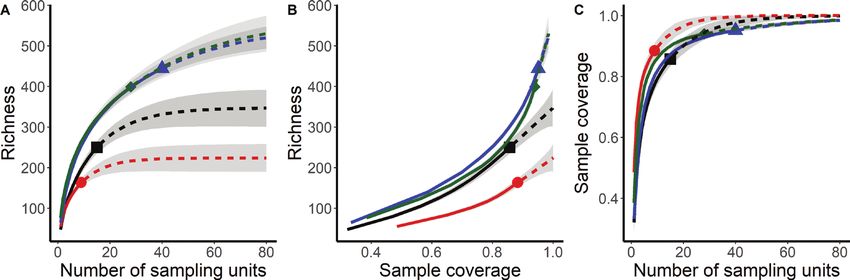
6                                              Sebastián R. Zeballos et al.: Vegetation types with Trithrinax campestris (Arecaceae)

      Keywords
      Chaco, chorotype, endemism, environmental variable, Espinal, floristic composition, palm, species richness, vegetation type

Introduction                                                         et al. 2011) such as climatic (e.g., water and temperature
                                                                     seasonality related variables), edaphic and anthropic (e.g.,
Trithrinax Martius is a neotropical genus of palms (Are-             agriculture, fire and herbivory) have not been explored
caceae) distributed in the subtropical and warm temperate            comprehensively for this palm species (Sayago 1969;
region of South America, from almost sea level up to an              Luti et al. 1979). Therefore, the vegetation types in which
elevation of 1,500 m (Cano et al. 2013). It belongs to the           T. campestris occurs, their composition and structure, as
subfamily Coryphoideae and to the tribe Cryosophileae                well as the relationship with the main environmental var-
(Dransfield et al. 2005, 2008), and occurs in Brazil, Ar-            iables are still to be documented.
gentina, Bolivia, Paraguay, and Uruguay (Henderson et al.                As many palms worldwide, T. campestris is a keystone
1995; Dransfield et al. 2008; Pintaud et al. 2008; Zuloaga           species for local people that traditionally use the leaves and
et al. 2008; Gaiero et al. 2012). Trithrinax comprises three         spines to make handicrafts such as baskets and a variety of
species (T. brasiliensis, T. schizophylla and T. campestris),        objects (Moraes 2001; Cano 2014). Moreover, this palm
widely distributed in different habitats and vegetation              is being evaluated for the production of biofuels. At the
types. The northern limit of its distribution lies in Santa          same time, vegetation types with T. campestris are threat-
Cruz Department, Bolivia, where T. schizophylla occurs,              ened because many habitats previously occupied by com-
while in the southern extreme of its range, in central Ar-           munities with palms are currently replaced by soybean
gentina and Uruguay, T. campestris is found (Cano et al.             and corn crops and also by pastures (Cano 2014; Mendo-
2013). Trithrinax species are more tolerant to drought and           za et al. 2016; and personal observation by the authors).
lower temperatures than other species of palms (Boyer                Knowledge of the effects of human activities (i.e., fire and
1992; Riffle and Craft 2003; Meerow 2005). Particularly,             grazing) on the population dynamics of T. campestris, as
it has been documented that T. campestris may resist even            well as its germination ecology, is still preliminary. Cano
less than -10°C (Meerow 2005), which may explain its dis-            (2014) reported an evident lack of seedlings and saplings
tribution at higher latitudes.                                       due to anthropogenic fires and cattle grazing, while Men-
    The distribution area of T. campestris is mainly re-             doza et al. (2016) highlighted the lack of new palm seed-
stricted to central Argentina (Cano et al. 2013) where the           lings related to extremely low seed germination observed
vegetation types in which the palm occurs, belong to the             in field and laboratory experiments. The persistent leaf-
Espinal and Chaco phytogeographical provinces (Cabrera               sheaths protect the stems of adult individuals what may
1976). Previous studies report the presence of this species          be an adaptation to anthropogenic originated fires (Cano
in various vegetation types with different soil and climat-          et al. 2013). Individuals of T. campestris seen in the field
ic conditions and different disturbance histories (Sayago            frequently show fire marks in the naked stems which lose
1969; Luti et al. 1979). In each habitat the importance of           their sheath layers (Cano et al. 2013 and personal observa-
T. campestris ranges from some scattered, isolated individ-          tions by the authors). However, seedlings are not resistant
uals, to locally dense populations where the species be-             to fire episodes, showing that fire may represent an impor-
comes dominant in the community (Sayago 1969). From                  tant threat for the long-term survival for Trithrinax wild
the phytogeographic point of view, Kurtz (1904), Sayago              populations (Cano et al. 2013). In the last decades mature
(1969) and Cabido et al. (2018) reported the occurrence              specimens have been exported to European countries for
of T. campestris in forests, grasslands or in savannas of            use in gardening (in 2003 the exportation of T. campes-
the Lowland Chaco area, while Giorgis et al. (2017) rec-             tris generated an income of 600,000 USD; SENASA, Ar-
ognized the presence of the palm as a co-dominant and                gentina,        http://www.senasa.gob.ar/senasa-comunica/
subordinate species across different vegetation types                noticias/). Furthermore, the invasion by exotic species
in the Mountain Chaco. Within the Espinal phytogeo-                  represents an additional potential threat for the vegetation
graphic province, Lewis and Collantes (1973) identified              types in which T. campestris occurs (Giorgis et al. 2017;
a floristic district based in part on the occurrence of this         Cabido et al. 2018; Zeballos et al. 2020). Cano et al. (2013)
species. More recently, Lewis et al. (2009) also reported            defined the conservation status of T. campestris as vulner-
the occurrence of some isolated patches of Espinal forests           able, mainly due to habitat destruction and conversion to
comprising T. campestris in the eastern area of Córdoba              agriculture, and further insights on vegetation types with
province, central Argentina. However, none of these stud-            T. campestris are urgently needed to develop proper con-
ies performed on Chaco or Espinal reported the complete              servation and management strategies.
floristic composition of the patches in which this palm oc-              This study aimed to describe for the first time the whole
curs. Moreover, the effect of those factors that have been           floristic composition of vegetation types of the main hab-
previously reported as major drivers influencing the dis-            itats in which T. campestris occurs in central Argentina.
tribution of palm vegetation types worldwide (Eiserhardt             Since disturbance may have introduced dramatic changes
Vegetation Classification and Survey 7
in the physiognomy of vegetation, we also explored the
patterns of life forms distribution. In addition, and taking
into account that the habitats in which T. campestris oc-
curs involve different phytogeographic units, we also es-
tablish the proportion of chorotypes and endemic species
present, as well as the origin of all the taxa recorded in
each vegetation type. Finally, the association between the
floristic composition and the main environmental varia-
bles (i.e., bio-climatic, topographic and edaphic) and fire
frequency, were assessed.
Methods Figure 1. A Location of the study area (Córdoba province)
in South-America; B Location of Córdoba province in cen-
Study area and vegetation survey tral Argentina and overall distribution of Trithrinax camp-
estris (black dots) in Argentina and Uruguay (according
The survey was conducted in central Argentina, Córdoba to Cano et al. (2013) and Flora australis database) and
province, covering ca. 161,000 km² (Figure 1). Sampling sample plots (relevés; white dots) collected in this study
sites were distributed in habitats where the presence of in Córdoba province. The location of Chaco (dark grey),
T. campestris had been reported in previous works by Espinal (light grey), and Pampa (intermediate grey) phy-
Kurtz (1904), Sayago (1969), Lewis and Collantes (1973) togeographic provinces in central and northern Argenti-
and Luti et al. (1979), as well as in sites where specimens na are depicted based on Cabrera (1976).
deposited in the Herbarium of the National University of
Córdoba (CORD) had been collected. The study area is extraction (Schofield and Bucher 1986) and the advances
partially included in the Espinal phytogeographic prov- of the agricultural frontier (Arturi 2005; Guida-Johnson
ince and the Western (Lowland) and Mountain Chaco and Zuleta 2013; Fehlenberg et al. 2017) have altered the
districts according to the phytogeographic scheme of Ar- original distribution patterns of vegetation types (Zak et
gentina (Cabrera 1976). Following the Biogeographic Map al. 2008; Hoyos et al. 2013; Agost 2015; Giorgis et al. 2017;
of South America by Rivas-Martínez et al. (2011), our veg- Cabido et al. 2018; Garachana et al. 2018; Kowaljow et al.
etation types are mainly included in the South Chacoan 2018; Zeballos et al. 2020).
Province within the Chacoan Region (Chaqueña), and in The study area is characterized by two main geomor-
the Xerophytic Pampean Region. The eastern extreme of phologic units: an old Cambric mountain system compris-
the study area belongs to the Espinal (Lewis and Collantes ing three main ranges and lowlands filled with Pleistocene
1973; Cabrera 1976; Zeballos et al. 2020), and is character- and Holocene sediments, distributed both to the east and
ized by seasonally dry subtropical forests and woodlands west of the mountains (Carignano et al. 2014). The study
distributed on lowlands with deep and well to imperfectly area comprises a climatic gradient from subtropical in the
drained soils, in the proximity of the Pampean phytogeo- lowland Espinal and Chaco areas (200 to 400 m), to warm
graphic province. The northern extreme occupies part of temperate in the northern and western mountain locali-
the Lowland Chaco ecosystem (Western Chaco District ties (500 to 1200 m). Average annual temperature ranges
sensu Cabrera, 1976) with xerophytic forests on well to from 17 to 20°C in the flat areas to 13 to 14°C in the north-
excessively drained soils and part of the Mountain Cha- ern and western hills (Cabido et al. 1998). Average annual
co District (Cabrera 1976) occupying low hillsides and rainfall is highest in the north-east, ranging from 700 to
slopes with shallow and rocky substrates and small valley 900 mm, decreasing to less than 600 mm to the west of
bottoms with deeper soils. Finally, the western extreme the study area. Over the whole area, more than 80% of
of the study area also belongs to the Mountain Chaco the rainfall is concentrated from October to March (warm
District; the landscape is dominated by open woodlands season in Southern Hemisphere).
and scrublands on dry gentle and steep slopes alternating The vegetation survey was designed to cover the ge-
with flat areas (“pampas”) with deeper soils and narrow ographic, topographic and ecological variability of
valley bottoms likely to suffer occasional flooding. At the vegetation types in which T. campestris is present re-
beginning of the 20th century, the study area was covered gardless of its abundance (Figure 2). Sampling fol-
by xerophytic forests dominated by Aspidosperma quebra- lowed the Zürich-Montpellier School of phytosociology
cho-blanco, Schinopsis lorentzii and species of Prosopis in (Braun-Blanquet 1932), and comprised 92 georeferenced
the lowlands. In the mountains, the landscape was dom- 20 × 20 m2 plots. In each plot, all vascular plants were
inated by a mosaic of woodlands, shrublands and grass- recorded and species cover was estimated using the cov-
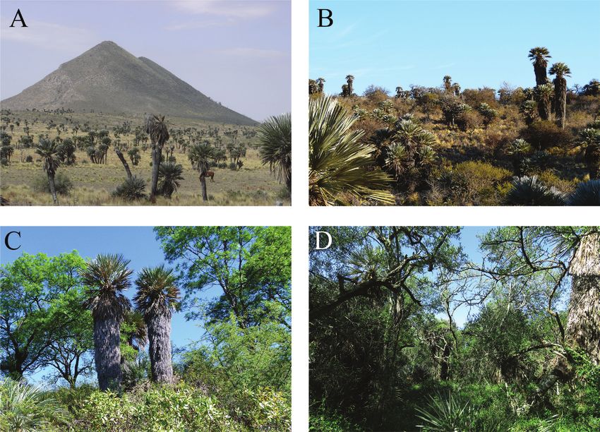
lands and the main tree species were Lithraea molleoides, er-abundance scale of Braun-Blanquet (1932) (+=8 Sebastián R. Zeballos et al.: Vegetation types with Trithrinax campestris (Arecaceae) Figure 2. Examples of vegetation types comprising Trithrinax campestris in the study area in central Argentina. A Palm savanna with T. campestris in a matrix of grasslands on gentle hillside slopes; B Scrubland dominated by Vachellia caven and T. campestris on rocky soils; C Mountain Chaco forest dominated by Schinopsis marginata with scattered individuals of T. campestris on steep mountain slopes; and D Espinal forest with Celtis tala, Prosopis nigra and T. campestris on deep soils in lowland areas. their distributional range and species origin (i.e., native Environmental variables or exotic) followed the catalogue of vascular plants of the Southern Cone (Zuloaga et al. 2008) and its online up- Bioclimatic variables and elevation were interpolated date (http://www.darwin.edu.ar/). Endemic taxa at the from the WorldClim database (http://www.worldclim. national and local levels followed Giorgis et al. (under re- org; Fick and Hijmans 2017), at a spatial resolution of 30 view). Endemic at the local levels means endemic species seconds (ca. 1 km2) for continental South America. As the restricted to the study area and surrounding provinces main bioclimatic variables that constrain the distribution (mainly Córdoba and San Luis). Fourteen out of the 92 of palm species and communities worldwide are related to vegetation plots are registered in the Global Index of Veg- water availability and temperature (Eiserhardt et al. 2011) etation-Plot Database (Dengler et al. 2011; http://www. the following variables were selected: Precipitation of the givd.info) under ID SA-AR-002. Wettest Quarter(PWeQ), Minimum Temperature of the To assess the main trends of species distribution patterns Coldest Month (MTCM), Precipitation Seasonality (PS), and their representation in the study area, species choro- Precipitation of the Wettest Month (PWeM), Annual Pre- types (groups of species with a similar distribution), were cipitation (AP), and Precipitation of the Driest Quarter assigned following the criteria proposed by Cabido et al. (PDQ) (see O’Donnell and Ignizio 2012 for details con- (1998) and Zeballos et al. (2020): Southern-Brazilian (1), cerning all the bioclimatic variables). To obtain data on Chaquenian (2), Low Mountain Chaco (3), Arid Chaco and topographic and edaphic variables for each plot (slope Monte (4) and Exotic (5). Additionally, the mean percentage and organic matter content of the surface soil layer), all of each chorotype per plot as well as the mean species rich- the 92 relevés were plotted on digitalized maps of the soils ness and number of exotics per relevé were calculated. Life of Córdoba province provided at two different scales (i.e., forms followed Zeballos et al. (2020) thus sorted as: cactus 1:500,000 and 1:50,000) (Gorgas and Tassile 2006; http:// (c), climber (cl), epiphyte (e), fern (f), grass (g), graminoid visor.geointa.inta.gob.ar/?p=857). The 1:50,000 scale was (gr), herb (h), parasite (p), palm (pl), shrub (s) and tree (t). preferentially used, but some information gaps at this
Vegetation Classification and Survey                                                                                  9

scale were completed with data provided by the map at            Zeballos et al. 2020). Chao2, Jackknife 1 and Jackknife 2
1:500,000. Both maps depict soil cartographic units and          non-parametric estimators for incidence data were used to
describe the internal heterogeneity of each unit through         estimate the total number of species that would be present
representative soil profiles providing an analysis of their      in each vegetation type. Further, the coverage estimate for
chemical and physical properties.                                each plant community is given because it represents the
    Following Argañaraz et al. (2015a) and Argañaraz et al.      estimated fraction of the entire population of individuals
(2020) the fire history frequency was characterized for the      in the community that belong to the species represented
92 sampling sites.Time series of Landsat TM, ETM+, and           in the sample. Non-parametric estimators for incidence
OLI images (30 m of spatial resolution), covering the study      data, and incidence-based rarefaction and extrapolation
area, acquired between 1999 and 2018 were used. This fire        (R/E) curves were performed using the SpadeR and iNEXT
database was derived automatically using ABAMS (Auto-            R-packages (Chao and Chiu 2016), respectively. Analyses
matic Burned Area Mapping Software), a tool based on             of variance were performed in order to evaluate the differ-
the algorithm proposed by Bastarrika et al. (2011) and           ences in mean species richness, mean percentage of each
updated versions implemented in Google Earth Engine.             chorotype per relevé as well as the differences in the mean
We considered any continuous burned patch as a single            species richness and number of exotics per relevé among
fire event except when the intensity of the burned signal        vegetation types. In all cases, the normality of the data and
was markedly different. Specifically, fire frequency is the      the homoscedasticity of variances were checked and when
number of times that a plot was burned for the period of         these requirements were not met, the data were natural
time considered. The minimum mapping unit of the fire            log transformed. The relationship between the floristic
database is of 5 ha (Argañaraz et al. 2015a). We converted       composition and fire frequency as well as bioclimatic and
vector layers of burned areas to raster format as binary         edaphic variables was assessed through the envift function
layers (burned or unburned) and determined the fire fre-         from the vegan R-package (http://CRAN.R-project.org/
quency for the 92 sites.                                         package=vegan). Bioclimatic and elevation data extrac-
                                                                 tions were conducted using the extract function. Those
                                                                 variables with the highest squared correlation coefficient
Data analyses                                                    were related to the ISOMAP ordination. Furthermore, to
                                                                 evaluate how the vegetation structure of stands, as well as
The ISOmetric feature mapping and Partition Around               T. campestris cover, were affected by fire frequency, ANO-
Medoids (ISOPAM) ordination and classification method            VAs were performed. All analyses and graphs were per-
were employed to analyze the 92 relevés. This analysis was       formed in R version 3.5.1 (R Core Team 2018).
used to detect the major vegetation types and their cor-
responding diagnostic species groups (Schmidtlein et al.
2010; Černý et al. 2015; Cabido et al. 2018). Hierarchical       Results
ISOPAM was run on the Bray-Curtis dissimilarity matrix.
This matrix was constructed with the floristic table after       Floristic composition
Braun-Blanquet scores were transformed to the central
class values (Kent 2012). The maximum number of clus-            A total of 601 vascular plant species and infraspecific taxa
ters on each hierarchical level was arbitrarily set to ten and   (555 natives, including 68 endemics and 46 exotics), dis-
standardized G statistics to five. For each vegetation type,     tributed among 77 families and 333 genera, were recorded
diagnostic species were selected using the phi coefficient       in the 92 relevés (Table 1 and see also Suppl. material 1:
of fidelity (Chytrý et al. 2002). Those species with phi ≥       Table S1.1). The most common families were Poaceae (108
0.1 and a statistically significant association (p < 0.001)      species), Asteraceae (104), and Fabaceae (43), which to-
with a particular vegetation type according to Fisher’s          gether accounted for 42.4% of all species. Other common
exact test, were considered as diagnostic. These analyses        families were Euphorbiaceae (27 species), Solanaceae
were performed in the JUICE 7.0 program (Tichý 2002).            (26), Malvaceae (24), Cactaceae and Verbenaceae (22 spe-
Each vegetation type was named after the first two spe-          cies each). The most common genera were Baccharis, (13
cies that showed: 1) phi ≥ 0.2 and a statistically significant   species), Euphorbia (12), Solanum (11), Tillandsia (10),
(p < 0.001) association with a given vegetation type; and        Nassella and Croton (8 species each). The predominant
2) constancy >30%. The vegetation matrix was ordinated           life forms were herbs (264 species), followed by grasses
through isometric feature mapping (ISOMAP; Tenem-                (108), shrubs (88), climbers (46), trees (27) and cacti (22).
baum et al. 2000; Černý et al. 2015), using the number of        The most prominent chorotype was the Southern-Bra-
neighbors to the optimal value from the first hierarchical       zilian (56.08 ± 11.73% of all species, mean plus standard
level of the ISOPAM classification.                              deviation), followed by the Chaquenian (29.67 ± 13.15%),
   Incidence-based rarefaction and extrapolation (R/E)           the Low Mountain Chaco (11.08 ± 5.65%), and the Arid
curves using sample size-based and coverage-based meth-          Chaco and Monte (0.12 ± 0.43%) chorotypes. Exotics were
ods were performed to evaluate whether plant species             represented by 3.05 ± 3.19% of all species. The overall cov-
from the different vegetation types classified by the ISO-       er of T. campestris in the 92 relevés ranged from less than
PAM method were well represented (Budka et al. 2018;             1% to almost 40%.
10 Sebastián R. Zeballos et al.: Vegetation types with Trithrinax campestris (Arecaceae)
Table 1. Synoptic table of the vegetation types classified LF CT Cluster 1 Cluster 2
by ISOPAM analysis showing the percentage constancy, Vegetation type 1.1 1.2 2.1 2.2
Tripogonella spicata g 1 11.1+ 5+ 39.31
mean Braun-Blanquet cover (as superscript) and phi values
Baccharis linearifolia s 1 15+ 53.6+
based on 92 relevés collected in Córdoba province, central Microchloa indica var. indica g 1 11.1+ 10+ 46.41
Argentina. Species are sorted by decreasing fidelity within Schizachyrium salzmannii g 1 2.5+ 251
each vegetation type. Dark, medium and light grey indi- Andropogon ternatus g 1 2.51 251
Eustachys retusa g 1 11.1+ 601 78.61
cates phi ≥ 0.3, phi ≥ 0.2 and phi ≥ 0.1, respectively. Vegeta-
Gomphrena perennis var. perennis h 1 6.71 101 42.91
tion type codes: 1.1 Celtis tala/Sida rhombifolia closed for- Glandularia peruviana h 1 11.1+ 45+ 71.4+
est; 1.2 Aspidosperma quebracho-blanco/Prosopis kuntzei Margyricarpus pinnatus s 1 15+ 57.1+
open forest; 2.1 Jarava pseudoichu/Vachellia caven open Glandularia venturii h 2 15+ 57.1+
savanna; 2.2 Acalypha variabilis/Nassella cordobensis scru-
bland. Life forms (LF): c: cactus; cl: climber; e: epiphyte; f: Vegetation classification
fern; g: grass; gr: graminoid; h: herb; p: parasite; pl: palm;
s: shrub; t: tree. Chorotypes (CT): (1) Southern-Brazilian, The vegetation matrix was classified by the ISOPAM anal-
(2) Chaquenian, (3) Low Mountain Chaco, (4) Arid Chaco ysis into two main clusters (C1 and C2) and each cluster
and Monte, (5) Exotic. Symbols: °: endemics at local level; was further partitioned into two vegetation types (Table 1).
*: endemics at the national level. Species constancy and average cover data are reported in
LF CT Cluster 1 Cluster 2 synoptic Table 1 and also in the extended Suppl. material 1:
Vegetation type 1.1 1.2 2.1 2.2 Table S1.1. Cluster 1 comprised relevés collected mainly in
Number of relevés 15 9 40 28 the plains located to the east and north of the study area (Es-
Trithrinax campestris pl 2 1002 1001 1002 1001
Diagnostic species
pinal and the Lowland Chaco, respectively), while Cluster 2
Sida rhombifolia h 1 66.71 11.1+ 7.5+ 3.6+ included relevés distributed predominantly, but not exclu-
Celtis tala t 1 1002 77.82 551 46.41 sively, in low mountain ranges and valley bottoms located
Nassella hyalina g 1 402 51 to the north and west of the area (Lowland Chaco and the
Rivina humilis h 1 66.71 11.1+ 5+ 3.6+
Mountain Chaco, respectively). Although the sample-size-
Dicliptera squarrosa h 1 53.32 12.5+ 10.7+
Malvastrum coromandelianum h 1 73.31 22.2+ 20+ 10.7+ based rarefaction showed that the curves of the four vege-
Holmbergia tweedii s 2 33.31 tation types had not yet reached the asymptote (Figure 3A),
Schinus longifolius s 2 46.71 11.1+ 10+ 3.6+ the observed species richness reached a high percentage of
Capsicum chacoënse s 2 40+ 7.5+
the species estimated using the non-parametric estimators
Cyperus hermaphroditus gr 1 26.7+
Araujia odorata cl 1 53.3+ 22.2+ 5+ 3.6+
(Table 2). The coverage-based rarefaction curves suggested
Prosopis kuntzei t 2 88.92 that the four vegetation types identified were well repre-
Sarcomphalus mistol t 2 6.7+ 88.92 sented since the sample coverage percentage showed values
Jarava ichu var. ichu g 3 55.62 102
equal or higher than 0.85 in all types (Figure 3B, C; Table 2).
Aspidosperma quebracho-blanco t 2 13.31 1001 10+
Vachellia aroma s 2 66.71 7.51 3.6+
Senegalia praecox t 2 13.32 88.91 2.5+ 3.61 Table 2. Species observed (Sobs) and non-parametric es-
Mimosa detinens s 2 55.6+ timators of species richness plus standard error for in-
Deinacanthon urbanianum e 2 6.71 88.9+ cidence data for each vegetation type. Vegetation type
Monteverdia spinosa s 2 6.7+ 77.8+ 5+
codes: 1.1 Celtis tala/Sida rhombifolia closed forest; 1.2
Nicotiana glauca s 1 44.4+
Gouinia paraguayensis g 2 44.4+ 3.6+
Aspidosperma quebracho-blanco/Prosopis kuntzei open
Croton lachnostachyus s 3 33.31 77.81 17.5+ 10.7+ forest; 2.1 Jarava pseudoichu/Vachellia caven open sa-
Tillandsia aizoides* e 2 13.3+ 55.6+ 10+ vanna; 2.2 Acalypha variabilis/Nassella cordobensis scru-
Castela coccinea t 2 55.6+
bland. Estimators: Chao2-bc: a bias-corrected form for
Opuntia quimilo c 2 66.7+ 3.6+
Cleistocactus baumannii c 2 44.4+
the Chao2 estimator; Jackknife 1: Estimator that use
Atamisquea emarginata s 2 44.4+ the frequency of uniques; Jackknife 2: Estimators that
Pseudabutilon pedunculatum h 2 13.3+ 66.7+ 2.5+ use the frequencies of uniques and duplicates; and C.
Leptochloa crinita g 2 6.7+ 44.4+ hat: Sample coverage index.
Harrisia pomanensis c 2 44.4+ 3.6+
Synedrellopsis grisebachii h 2 66.7+ 5+ 7.1+ Non-parametric 1.1 1.2 2.1 2.2
Melica argyrea g 1 33.3+ estimators
Jarava pseudoichu g 3 46.71 853 71.42 Sobs 250 163 444 399
Prosopis campestris° t 2 32.52 3.6+ Chao2-bc 344.72±24.06 220.80±19.35 553±25.17 568.29±39.99
Condalia microphylla* s 2 33.31 100+ 77.51 251 Jackknife 1 351.73±14.02 219.89±10.37 570.75±15.82 527.25±15.87
Lippia turbinata f. turbinata s 2 20+ 11.11 701 501 Jackknife 2 400.33±23.25 249.25±16.67 625.75±26.96 606.93±26.90
Vachellia caven s 1 53.31 11.11 97.52 1002 C. hat 0.86 0.88 0.95 0.94
Acalypha variabilis h 1 26.71 451 96.42
Nassella cordobensis* g 3 151 64.31
Krapovickasia flavescens h 1 6.7+ 11.1+ 45+ 89.31
Aristida circinalis g 1 2.5+ 28.61 Descriptions of the vegetation types are given below:
Sporobolus indicus g 1 6.71 17.5+ 60.71
Aristida adscensionis g 2 11.1+ 401 67.91 Cluster 1: Comprises two vegetation types distributed
Condalia montana* t 3 202 11.1+ 201 64.31
mainly in the lowlands of the Espinal phytogeographicalVegetation Classification and Survey 11
Figure 3. A Sample-size-based; B Coverage-based rarefaction and extrapolation sampling curves for species rich-
ness; C Sample completeness curves for each vegetation type. Solid line segments indicate rarefaction and dotted
line segments indicate extrapolation (up to a maximum sample size of 40), while shaded areas indicate 95% confi-
dence intervals (based on a bootstrap method with 100 replications). Colours and symbols: black square, 1.1 Celtis
tala/Sida rhombifolia closed forest; red circle, 1.2 Aspidosperma quebracho-blanco/Prosopis kuntzei open forest; blue
triangle, 2.1 Jarava pseudoichu/Vachellia caven open savanna; green diamond, 2.2 Acalypha variabilis/Nassella cor-
dobensis scrubland.
province (and marginally in the adjacent Pampean territo- 1.2 Aspidosperma quebracho-blanco/Prosopis kuntzei
ry) (Vegetation type 1.1) and the Western Chaco District open forest. Open forest with a tree layer cover of 30.67 ±
(Vegetation type 1.2) in the north-east and north of the 9.94% and a height of 6.06 ± 0.95 m. A dense shrub layer
study area, respectively. (59.44 ± 4.29%) with a height of 3.31 ± 0.3 m and a cover
of the herb layer of 55.56 ± 6.48% and a height of 0.56 ±
1.1 Celtis tala/Sida rhombifolia closed forest. Forests 0.02 m were recorded. Trithrinax campestris was a sub-
with a canopy height of 7.21 ± 0.39 m, dominated by a ordinated to other species and generally with low mean
group of tree species typical of the Espinal forests such cover values (5.34± 1.85%). Several tree species like Aspi-
as Celtis tala, Geoffroea decorticans and Prosopis nigra. dosperma quebracho-blanco, Prosopis kuntzei, Sarcompha-
The tree layer showed the highest average percent cover lus mistol, Senegalia praecox and shrubs such as Vachellia
value among the four vegetation types described (60.2 ± aroma, Mimosa detinens, Castella coccinea, Atamisquea
7.65%; mean plus standard error), followed by the herb emarginata, Monteverdia spinosa, were local dominants
layer with an average cover of 59.3 ± 8.34% and a height of and the diagnostic species for this type (Table 1). Also, di-
0.59 ± 0.07 m, while the shrub layer exhibited a height of agnostics were the succulent cacti Opuntia quimilo, Cleis-
2.64 ± 0.25 m and the lowest average cover (33 ± 5.97%). tocactus baumannii and Harrisia pomanensis, as well as
Trithrinax campestris reached its highest average cover in the C3 tussock grass Jarava ichu var. ichu.
this vegetation type (17.48 ± 4.12%) and co-dominated This vegetation type usually forms isolated patches sur-
the tree and/or the shrub layer in some of the relevés (e.g., rounded by soybean and corn crops in the lowlands of the
in some of them T. campestris showed a cover of 38%). The northern part of the study area. A total of 153 (146 natives
tree Celtis tala together with some shrubs such as Schinus and seven exotics) species were recorded in this vegeta-
longifolius and Capsicum chacoense, the herb Rivina hu- tion type of which 10 are endemic (eight at the national
milis, the grass Nassella hyalina and the climber Araujia and two at the local levels). The mean species richness
odorata were diagnostic for this vegetation type (Table 1). per relevé was 54.8 ± 3.24. The most abundant life forms
This vegetation type occurred mainly in the northeastern were herbs (57 species, 34.9%), shrubs (28 species, 17.2%),
plains of the study area on deep soils but some stands were grasses (32 species, 19.6%), trees (14 species, 8.6%) and
also found on the northern and western mountains occupy- climbers (13 species, 7.9%).
ing valley bottoms and gentle slopes, always on deep soils. In
mountain valley bottoms with poor drainage or even very Cluster 2: This Cluster includes two vegetation types
occasional flooding, T. campestris may also form pure stands. distributed mainly in low mountain slopes and valley bot-
A total of 231 (213 natives and 18 exotics) species were re- toms located in the Mountain Chaco District in the north
corded in this vegetation type, of which 19 are endemic (17 and west of the study area.
at the national and two at the local levels). The mean species
richness per relevé was 47.3 ± 3.31. Among life forms, herbs 2.1 Jarava pseudoichu/Vachellia caven open savanna.
(93 species, 37.2%) jointly with shrubs and grasses (46 spe- Open savannas with a high grass and herb cover (aver-
cies each, 18.4% each), were the most abundant, followed by age cover and height of the herbaceous layer were 78.28 ±
climbers (24 species, 9.6%) and trees (22 species, 8.8%). 3.59% and 0.74 ± 0.02 m, respectively). The average cover12 Sebastián R. Zeballos et al.: Vegetation types with Trithrinax campestris (Arecaceae)
of the tree and shrub layers was low (14.15 ± 2.16% and Richness and chorotype patterns among vege-
34.3 ± 2.69%, respectively) while their height also showed tation types
low values (4.64 ± 0.33 and 3.31 ± 0.1 m, for the tree and
shrub layers, respectively). Trithrinax campestris density The total number of vascular plant species per relevé
varied from only scattered individuals to denser patches ranged between 29 and 103, and the mean species rich-
in almost pure stands, reaching an average cover of 14.44 ness per relevé differed significantly among vegetation
± 2.11%. The C3 grass Jarava pseudoichu and the shrubs types (F3,88= 15.04; p = 0.001). The Acalypha variabilis/
Prosopis campestris, Condalia microphylla, Lippia turbina- Nassella cordobensis scrubland showed the highest mean
ta fo. turbinata and Vachellia caven were diagnostic spe- species richness per relevé (Table 3), while the Celtis tala/
cies for this vegetation type (Table 1). Sida rhombifolia closed forest had the lowest richness; the
This vegetation type was widely distributed across gen- other two vegetation types showed intermediate values.
tle slopes and valley bottoms mostly in the mountains of We recorded 52 endemic species at national level and 16 at
the northern part of the study area though some stands local level; only 5 endemic species (Gymnocalycium mostii;
are located to the west, on both gentle relief and more Gymnocalycium capillense; Apurimacia dolichocarpa; Al-
steep topography. In some stands, the dominant vegeta- ternanthera pumila and Trichocline plicata) were restricted
tion was an open scrubland dominated by Vachellia caven, to the study area and surroundings. Significant differences
while on slopes of the mountains to the west of the area in the representativeness of the different chorotypes were
remnants of Low Mountain Chaco Forest, dominated by observed among the vegetation types, with the exception of
Schinopsis marginata, Lithraea molleoides and Ruprechtia the Arid Chaco and Monte chorotype (Table 3). The vege-
apetala, with only sparse individuals of T. campestris, were tation types differed significantly in their Southern-Brazil-
found. A total of 406 (375 natives and 31 exotic species) ian chorotype representativeness (F3,88 = 23.34; p = 0.001)
species were recorded of which 39 are endemics (31 at the as well as in the Chaquenian chorotype (F3,88 = 40.73; p <
national and eight at the local levels). The mean species 0.001). The Southern-Brazilian chorotype was the best
richness per relevé was 64.3 ± 2.28. Herbs (197 species, represented with the exception of the Aspidosperma que-
44.3%), grasses (87 species, 19.5%) and shrubs (68 species, bracho-blanco/Prosopis kuntzei open forest in which the
15.3%) were the most common life forms. Chaquenian chorotype exhibited the highest percentage
of species (Table 3). Species of the Southern-Brazilian
2.2 Acalypha variabilis/Nassella cordobensis scrub- chorotype showed the highest proportion in the two veg-
land. Open scrubland with an almost continuous grass etation types of Cluster 2 and in Celtis tala/Sida rhombi-
and herb cover (the average cover of the herbaceous layer folia closed forest. The Arid Chaco and Monte chorotype
was 70.68 ± 4.73% with a height of 0.71 ± 0.05 m). Despite was less represented in the four vegetation types (i.e., less
that in some stands on rocky substrate the shrub cover than 1% on each one), and without significant differences
may increase, the average cover and height of this layer between them (F3,88 = 1.46; p = 0.23). The Low Mountain
were medium to low (35.18 ± 3.30% and 2.34 ± 0.14 m, re- Chaco chorotype also showed differences between vegeta-
spectively). Tree cover and height were the lowest among tion types (F3,88 = 9.34; p =Vegetation Classification and Survey 13
types (F3,88 = 6.52; p = 0.0005 and F3,88 = 4.4; p = 0.006, 340 to 436 m in average in Cluster 1. This elevation gradi-
respectively) with the highest values observed in the Celtis ent mirrored trends in temperature related variables (e.g.,
tala/Sida rhombifolia closed forest and the Jarava pseudoi- minimum temperature of coldest month). The vegetation
chu/Vachellia caven vegetation type (Table 3). types included in Cluster 1 occupied warmer areas with
higher precipitations with ca. 100 mm difference respect
to Cluster 2. Slope exhibited an appreciable range of varia-
Vegetation types, environmental variables and tion between both Clusters and was steeper in low moun-
fire frequency tain areas (Cluster 2). Organic matter content of the sur-
face soil layer showed higher average values in Cluster 1.
The ISOMAP ordination (Figure 4) showed that differenc- Out of the 92 stands, only 21 showed the frequency
es in floristic composition were related to elevation (Elev; of fires during the period 1999–2018. Overall, the fire
r2 = 0.44, p = 0.001;), minimum temperature of the coldest frequency was not related to the floristic composition
month (MTCM; r2 = 0.40, p = 0.001), precipitation of the (r2 = 0.04, p = 0.12). Eighteen sites were burned only once
driest quarter (PDQ; r2 = 0.37, p = 0.001), precipitation while three sites were burned three times during the pe-
of the wettest month (PWeM; r2 = 0.37, p = 0.001), an- riod analyzed. Those stands that belong to the vegetation
nual precipitation (AP; r2 = 0.37, p = 0.001), precipitation types of Clusters 2 showed a higher fire frequency since
seasonality (PS; r2 = 0.33, p = 0.001), precipitation of the 13 out of 40 stands were burned in the Jarava pseudoichu/
wettest quarter (PWeQ; r2 = 0.31, p = 0.001), organic mat- Vachellia caven open savanna while 4 out of 28 stands
ter content of the topsoil (OM; r2 = 0.29, p = 0.001) and were burned in the Acalypha variabilis/Nassella cordoben-
slope (r2 = 0.28, p = 0.001). Elevation was the most im- sis scrubland. The vegetation types of Cluster 1 showed
portant factor in relation to composition, with both vege- just two stands burned each. However, the four vegetation
tation types included in Cluster 2 characterized by mean types did not differ in their fire frequency (F3,84 = 2.16;
elevations higher than 900 m, while elevation ranged from p = 0.09). Furthermore, the vegetation structure of stands
(i.e., the percentage cover of each vegetation layer) of the
different vegetation types did not show any significant
differences between unburned and burned stands accord-
ing to their tree (F3,84 = 0.81; p = 0.49), shrub (F3,84= 0.39;
p = 0.76) and herb (F3,84 = 0.18; p = 0.9) layers cover as well
as in T. campestris cover (F3,84 = 0.46; p = 0.71).
Discussion
In this study we describe for the first time the complete
floristic composition of the main vegetation types in
which T. campestris occurs in central Argentina. Our re-
sults evidenced that either as isolated individuals inter-
mingled in forests (Cluster 1), in savannas and scrublands
(Cluster 2), or as denser populations (likely in both Clus-
ters) (Table 1 and Figure 4), this palm is able to occupy
sites with different topography and soils along a wide gra-
dient of environmental conditions. This wide gradient of
environmental conditions was already observed by former
Figure 4. Isometric feature mapping plot (ISOMAP), botanists who studied the flora in central Argentina more
based on Bray-Curtis dissimilarity of 92 relevés × 601 than one hundred years ago (Lorentz 1876; Kurtz 1904),
plant species matrix for those vegetation types that and several decades before our survey (Sayago 1969; Luti
include Trithrinax campestris in central Argentina. Vege- et al. 1979); however, none of them included complete flo-
tation type codes: 1.1 Celtis tala/Sida rhombifolia closed ristic inventories.
forest; 1.2 Aspidosperma quebracho-blanco/Prosopis
kuntzei open forest; 2.1 Jarava pseudoichu/Vachellia
caven open savanna; 2.2 Acalypha variabilis/Nassella Richness, endemism and chorological patterns
cordobensis scrubland. Environmental variables abbre- among vegetation types
viations: Elev: Elevation; MTCM: Minimum Temperature
of Coldest Month; PWeQ: Precipitation of the Wettest Relevés included in Cluster 2 revealed higher mean
Quarter; PS: Precipitation Seasonality, PWeM: Precipi- species number if compared with Cluster 1. The higher
tation of the Wettest Month; AP: Annual Precipitation; species richness recorded in vegetation types of Clus-
PDQ: Precipitation of the Driest Quarter; OM: Organic ter 2 (Jarava pseudoichu/Vachellia caven open savanna
matter. Colours: green, Cluster 1; red, Cluster 2. and Acalypha variabilis/Nassella cordobensis scrubland)14 Sebastián R. Zeballos et al.: Vegetation types with Trithrinax campestris (Arecaceae)
(Table 3), might reflect the topographic and edaphic het- Cabido et al. (1998) and Zeballos et al. (2020) for woody
erogeneity observed in the Low mountain Chaco habitats vegetation types from central Argentina including main-
occupied by these vegetation types. In mountain envi- ly lowland vegetation types. The predominance of these
ronments, topography may influence the distribution of chorotypes is not surprising since our study area includes
plant species and vegetation types by modifying soil prop- sedimentary plains and low mountain habitats. Moreo-
erties, exposure, and temperature, as well as vegetation ver, there are not significant barriers to the dispersal of
physiognomy and dynamics (Svenning 2001; Eiserhardt taxa distributed in the eastern and northeastern area of
et al. 2011). In contrast, both vegetation types included the country (Southern-Brazilian chorotype) and from the
in Cluster 1 (Celtis tala/Sida rhombifolia closed forest and northern flatlands of the Great Chaco in the northern re-
Aspidosperma quebracho-blanco/Prosopis kuntzei open gion of Argentina, but also Bolivia and Paraguay (Chaque-
forest), are distributed in more homogeneous landscapes nian chorotype) (Fuentes and Navarro 2000; Steininger et
found in the plains and flatlands of the Espinal and Cha- al. 2001; Navarro et al. 2006). Many of the species reported
co domains. Vegetation types in Cluster 2 are also richer in our survey with a Southern-Brazilian distribution have
in species than other woody communities of plains and also been mentioned by Rodriguez et al. (2017) as com-
low mountain habitats in central Argentina (Giorgis et ponents of Butia yatay palm groves and gallery forests in
al. 2017; Cabido et al. 2018; Zeballos et al. 2020). Similar northeastern Argentina, where T. campestris is a subordi-
patterns of higher species diversity reflecting habitat het- nate element.
erogeneity have been reported elsewhere in the world for The overall number of exotics in our survey is lower
different types of vegetation (Whittaker 1960; Coblentz with respect to those reported in previous floristic studies
and Riiters 2004; Kreft and Jetz 2007) and specifically for from central Argentina (Giorgis and Tecco 2014; Cabido
communities rich in palm species (Guimarães et al. 2002; et al. 2018; Zeballos et al. 2020). The number of exotic
Resende et al. 2013). An additional factor influencing species ranged from 7 to 31 among the four vegetation
local species richness may be the physiognomy of vege- types, with Jarava pseudoichu/Vachellia caven open savan-
tation which, is the results of complex feedback between na showing the highest record, while the mean number of
climate, topography and disturbance (i.e., fire and graz- exotics per plot was maximum in Celtis tala/Sida rhombi-
ing) (Giorgis et al. 2017; Argañaraz et al. 2020). Vegetation folia closed forest. Note that in this vegetation type even
types comprised in Cluster 1 exhibited higher tree canopy some exotics are considered diagnostic species (e.g., the
cover and the differences in their canopy openness could grass Chloris gayana and the tree Morus alba). This higher
determine gradients of light affecting the distribution of exotic occurrence may be explained by the earlier expan-
species. Cluster 2, instead, comprised open savannas and sion of agriculture in this area in comparison with that
scrublands allowing for more light availability at the shrub of the Aspidosperma quebracho-blanco/Prosopis kuntzei
and herb layers (Figure 2), which may enhance plant spe- open forest, where the introduction of intensive agricul-
cies richness. Strong influence of light gradients through ture is more recent (Zak et al. 2008; Cabido et al. 2018;
competition for light and shade tolerance has been report- Zeballos et al. 2020).
ed in other biomes, especially in tropical forests (Carson
and Schnitzer 2008), but at the moment, our evidence is
scarce and needs further research. Vegetation types and environmental factors
In addition to the variations in species richness among
the vegetation types (Table 3), differences in the compo- Within Cluster 1, trends in floristic composition were
sition of endemic species were also observed. Vegetation mainly related to annual rainfall, other precipitation pa-
types included in Cluster 2 showed the highest numbers of rameters associated to it, and the minimum temperature
endemic species both at the national and local levels. Jara- of the coldest month (Figure 4). On the other side, in
va pseudoichu/Vachellia caven open savanna and Acalypha Cluster 2 composition was mainly driven by elevation and
variabilis/Nassella cordobensis scrubland comprised 8 and topography but also by precipitation seasonality. Celtis
12 endemism at local level, respectively, which evidenced tala/Sida rhombifolia closed forest and Aspidosperma
the high natural value of these vegetation types and their quebracho-blanco/Prosopis kuntzei open forest occurred
importance for biodiversity conservation. The valuable at the warmest part of the study area where annual rain-
pattern of endemism reflected in our data could be ex- fall is higher, whereas Jarava pseudoichu/Vachellia caven
plained through the isolating effect of mountains with re- open savanna and Acalypha variabilis/Nassella cordoben-
spect to lowlands; recent studies report a clear correlation sis scrubland occupied the highest and coldest habitats in
between plant endemism and mountain isolation (Stein- premontane hills to the north and west of the study area.
bauer et al. 2016; Camacho-Sanchez et al. 2019). Despite Areas at higher elevations are characterized not only by
our findings, the distribution of many taxa is still scarcely lower temperatures, but also by different topographic con-
known in Argentina and further floristic and chorological ditions and rocky soils that which may avoid the establish-
studies could change the status of many plant species. ment of species from the lowland Espinal and Chaco areas
The Southern-Brazilian and Chaquenian chorotypes (Cabido et al. 2018; Zeballos et al. 2020).
were dominant in all the four vegetation types described Despite of the environmental differences between
(Table 3). The same pattern has also been reported by the vegetation types described, our results showed thatVegetation Classification and Survey 15
T. campestris can grow in a wide range of environmen- of community types with different environmental con-
tal conditions. In line with our results, previous studies ditions. These results are essential to develop adequate
dealing with palm communities in tropical and sub- conservation strategies and useful for the sustainable
tropical areas have emphasized the occurrence of palm management of this endangered species. It is accept-
species in different habitat types, such as floodplains, ed that the current distribution of palms is limited by
terraces, swamps, premontane hills, and even dry lands climatic conditions prevailing during the cold season
(Navarro 1997; Navarro et al. 2006; Balslev et al. 2010; (Walther 2002), and that under warming scenarios some
Eiserhardt et al. 2011; Resende et al. 2013; Rodríguez et palm species may be extending their ranges into high-
al. 2017). We should note that this species grows in warm er latitudes and altitudes (Walther et al. 2007; Giorgis et
temperate areas and sites not necessarily subjected to al. 2015). However, to our knowledge, there is no infor-
temporary or permanent flooding, as has been observed mation about the behavior that T. campestris may show
in many species of the family Arecaceae (Eiserhardt et al. under changing scenarios of temperature and rainfall
2011). Bjorholm et al. (2006) suggested that for species neither about its regeneration niche. Preliminary field
within the Coryphoideae subfamily, the present-day en- observations suggest that a high number of seedlings
vironmental regional factors have low explanatory pow- could be associated with higher tree canopy cover while
er in its current distribution while non-environmental in more open sites the lack of regeneration could be
regional factors and/or long-term disturbance factors related to more vulnerable populations. Future studies
might have historically constrained their distribution. As should extend the floristic survey to other areas in which
Dalle et al. (2002) and Svenning et al. (2004) remarked, the vegetation types comprising T. campestris have been
some palm species may be associated with disturbanc- reported (Cano et al. 2013; 2014), especially in San Luis
es that occurred more than 20 years ago. In this sense, and Santiago del Estero provinces, also located in central
a climatic reconstruction of central Argentina not only Argentina (see Figure 1). Similarly, future successional
observed the presence of silicophytolith of the Arecaceae and demographic studies should complement our sur-
family but also registered a peak of higher aridity and vey in order to give a more complete picture of the real
warm climate experimented 1,600 years ago (Giorgis et conservation status of the species and of the vegetation
al. 2015). These climatic conditions might have allowed types in which it occurs.
that T. campestris reached the southernmost distribution
in central Argentina.
Several authors have pointed to the effect of range Data availability
management (e.g., fire and cattle grazing) on the physi-
ognomy and composition of vegetation types comprising A subset of the plots is included in the database SA-AR-002
other Argentinian palm species (Morello and Adamoli – Vegetation of Central Argentina(Dengler et al. 2011;
1974; Biani et al. 2007; Cabral and Castro 2007; Batista http://www.givd.info). The remaining subset will be includ-
et al. 2014). Fire is a common and important disturbance ed in the same database in 2021. The data are also available
driver in central Argentina and particularly in the study from the Corresponding author upon reasonable request.
area (Argañaraz et al. 2015 a, b, 2020). Observations in
the early works by Sayago (1969) and Luti et al. (1979),
as well as more recent findings by Giorgis et al. (2013), Author contributions
Carbone et al. (2017) and Kowaljow et al. (2018), high-
light the effect of fires on the structure and composition SRZ, MRC, MAG, designed the survey; MAG, MRC, JJC,
of Chaco vegetation in Córdoba. However, we registered ATRA, PIM, did the field work; SRZ, MRC performed
a low fire frequency in the plots surveyed (i.e., 21 out of data analysis; SRZ, MAG, MRC, ATRA, JJC wrote the
the 92 sampling sites were burned) at least for a period original manuscript; JA analyzed fire data; MVP, JA, PIM,
of twenty years. This result suggests that other drivers, PAT, AF, GF, MVV, GC contributed substantially to the
such as land use change and grazing may be more im- final writing of the manuscript and in the interpretation
portant determining the structure and floristic patterns of results.
of those vegetation types in which T. campestris grows
naturally. Nevertheless, our data concerning the effect of
fires are only preliminary and longer time series of fire Acknowledgements
frequency are needed.
We thank Ángela Cano for advice on the overall distribu-
tion of T. campestris. This research was partially supported
Conclusions and further perspectives by the Consejo Nacional de Investigaciones Científicas y
Técnicas (CONICET), the Ministerio de Ciencia y Tec-
This study provides a detailed analysis of the vegetation nología de la Provincia de Córdoba (MINCyT – Córdoba,
types comprising T. campestris, the only native palm spe- No. 000007/2019), the Secretaría de Ciencia y Tecnología
cies in the flora from central Argentina. Moreover, our (SECyT – UNC), the Universidad Nacional de Río Cuarto
study highlights that T. campestris can grow in a variety and Neotropical Grassland Conservancy.16 Sebastián R. Zeballos et al.: Vegetation types with Trithrinax campestris (Arecaceae) References Argañaraz JP, Pizarro GG, Zak M, Bellis LM (2015a) Fire regime, cli- Camacho-Sanchez M, Hawkins MTR, Yu FTY, Maldonado JE, Leon- mate, and vegetation in the sierras de Córdoba, Argentina. Fire Ecol- ard JA (2019) Endemism and diversity of small mammals along ogy 11: 55–73. https://doi.org/10.4996/fireecology.1101055 two neighboring Bornean mountains. PeerJ 7: e7858. https://doi. Argañaraz JP, Pizarro GG, Zak M, Landi MA, Bellis LM (2015b) Human org/10.7717/peerj.7858 and biophysical drivers of fires in semiarid Chaco mountains of cen- Cano A, Perret M, Stauffer FW (2013) A revision of the genus Trithrinax tral Argentina. Science of the Total Environment 520: 1–12. https:// (Cryosophileae, Coryphoideae, Arecaceae). Phytotaxa 136: 1–53. doi.org/10.1016/j.scitotenv.2015.02.081 https://doi.org/10.11646/phytotaxa.136.1.1 Argañaraz JP, Cingolani AM, Bellis LM, Girogis MA (2020) Fire inci- Cano A (2014) A subtropical quest to discover wild Trithrinax. Palms dence along an elevation gradient in the mountains of central Ar- 52: 65–71. gentina. Ecología Austral 30: 268–281. https://doi.org/10.25260/ Carbone LM, Aguirre-Acosta N, Tavella J, Aguilar R (2017) Cambios EA.20.30.2.0.1054 florísticos inducidos por la frecuencia de fuego en el Chaco Serrano. Balslev H, Eiserhardt W, Kristiansen T, Pedersen D, Grandez C (2010) Boletín de la Sociedad Argentina de Botánica 52: 753–778. https:// Palms and palm communities in the upper Ucayali river valley – a doi.org/10.31055/1851.2372.v52.n4.18861 little known region in the Amazon basin. Palms 54: 57–72. Carignano C, Kröhling D, Degiovanni S, Cioccale M (2014) Geomor- Bastarrika A, Chuvieco E, Pilar Martín M (2011) Automatic Burned Land fología Relatorio. XIX Congreso Geológico Argentino, Córdoba, AR. Mapping from MODIS time series images: Assessment in Mediter- Carson WP, Schnitzer SA (2008) Tropical forest community ecology. Wi- ranean Ecosystems. IEEE Transactions on Geoscience and Remote ley-Blackwell, Chichester, UK. Sensing 49: 3401–3413. https://doi.org/10.1109/TGRS.2011.2128327 Castellanos A, Ragonese AE (1949) Distribución geográfica de algunas Batista WB, Rolhauser AG, Biganzoli F, Burkart SE, Goveto L, Maranta palmas del Uruguay. Lilloa 20: 251–261. A, Genoveva Pignataro A, Morandeira NS, Rabadán M (2014) Las co- Černý T, Kopecký M, Petřik P, Song J, Šrůtek M, Valachovič M, Altman J, munidades vegetales de la sabana del parque nacional el palmar (Ar- Doležal J (2015) Classification of Korean forests: Patterns along geo- gentina). Darwiniana, nueva serie 2: 5–38. https://doi.org/10.14522/ graphic and environmental gradients. Applied Vegetation Science 18: darwiniana.2014.21.569 5–22. https://doi.org/10.1111/avsc.12124 Biani NB, Middleton J, Romano MC (2007) Applied biodiversity con- Chao A, Chiu CH (2016) Nonparametric estimation and com- servation linked to sustainable development in a Chaco ecosystem in parison of species richness. In: eLS (Encyclopedia of Life Sci- northern Santa Fe province, Argentina. International Journal of En- ences). John Wiley and Sons, Ltd, Chichester, UK. https://doi. vironmental, Cultural, Economic and Social Sustainability 2: 53–62. org/10.1002/9780470015902.a0026329 https://doi.org/10.18848/1832-2077/CGP/v02i07/54300 Chytrý M, Tichý L, Holt J, Botta-Dukát Z (2002) Determination of diag- Bjorholm S, Svenning JC, Baker WJ, Skov F, Balslev H (2006) Historical nostic species with statistical fidelity measures. Journal of Vegetation legacies in the geographical diversity patterns of New World palm Science 13: 79–90. https://doi.org/10.1111/j.1654-1103.2002.tb02025.x (Arecaceae) subfamilies. Botanical Journal of the Linnean Society Coblentz DD, Riitters KH (2004) Topographic controls on the re- 151: 113–125. https://doi.org/10.1111/j.1095-8339.2006.00527.x gional-scale biodiversity of the south-western USA. Journal of Boyer K (1992) Palms and Cycads Beyond the Tropics. Palm and Cycad Biogeography 31: 1125–1138. https://doi.org/10.1111/j.1365- Societies of Australia, Milton, AU, 150 pp. 2699.2004.00981.x Braun-Blanquet J (1932) Plant sociology. The study of plant communi- Dalle SP, Lopez H, Diaz D, Legendre P, Potvin C (2002) Spatial distribu- ties. McGraw-Hill, New York, US. tion and habitats of useful plants: an initial assessment for conserva- Brown JH (2001) Mammals on mountainsides: elevational patterns of tion on an indigenous territory, Panama. Biodiversity and Conserva- diversity. Global Ecology and Biogeography 10: 101–109. https://doi. tion 11: 637–667. https://doi.org/10.1023/A:1015544325763 org/10.1046/j.1466-822x.2001.00228.x Dengler J, Jansen F, Glöckler F, Peet RK, De Cáceres M, Chytrý M, Ewald Budka A, Łacka A, Szoszkiewicz K (2018) Estimation of river ecosystem J, Oldeland J, Finckh M, …, Spencer N (2011) The Global Index of biodiversity based on the Chao estimator. Biodiversity and Conser- Vegetation-Plot Databases (GIVD): a new resource for vegetation vation 27: 205–216. https://doi.org/10.1007/s10531-017-1429-2 science. Journal of Vegetation Science 22: 582–597. https://doi. Cabido M, Funes G, Pucheta E, Vendramini F, Díaz S (1998) A chorolog- org/10.1111/j.1654-1103.2011.01265.x ical analysis of the mountains from Central Argentina. Is all what we Dransfield J, Uhl NW, Asmussen CB, Baker WJ, Harley MM, Lewis CE call Sierra Chaco really Chaco? Contribution to the study of the flora (2005) A new phylogenetic classification of the palm family, Areca- and vegetation of the Chaco. Candollea 53: 321–331. ceae. Kew Bulletin 60: 559–569. Cabido M, Zeballos SR, Zak M, Carranza ML, Giorgis MA, Cantero JJ, Dransfield J, Uhl NW, Asmussen CB, Baker WJ, Harley MM, Lewis CE Acosta AT (2018) Native woody vegetation in central Argentina: (2008) Genera Palmarum. Royal Botanic Gardens Kew, Richmond, UK. Classification of Chaco and Espinal forests. Applied Vegetation Sci- Eiserhardt WL, Svenning JC, Kissling WD, Balslev H (2011) Geograph- ence 21: 298–311. https://doi.org/10.1111/avsc.12369 ical ecology of the palms (Arecaceae): determinants of diversity and Cabral EL, Castro M (2007) Palmeras argentinas, Guía para el recono- distributions across spatial scales. Annals of Botany 108: 1391–1416. cimiento. L.O.L.A, Buenos Aires, AR, 88 pp. https://doi.org/10.1093/aob/mcr146 Cabrera AL (1976) Regiones fitogeográficas argentinas. In: Kugler WF Fick SE, Hijmans RJ (2017) WorldClim 2: new 1‐km spatial resolution (Eds) Enciclopedia argentina de agricultura y jardinería. Acme, Bue- climate surfaces for global land areas. International Journal of Clima- nos Aires, AR, 1–85. tology 37: 4302–4315. https://doi.org/10.1002/joc.5086
You can also read