Satellite data for the offshore renewable energy sector: synergies and innovation opportunities - arXiv
←
→
Page content transcription
If your browser does not render page correctly, please read the page content below
Satellite data for the offshore renewable energy sector: synergies and
                                                                               innovation opportunities

                                                 E. Medina-Lopeza,∗, D. McMillanb , J. Lazicc , E. Hartb , S. Zena , A. Angeloudisa , E. Bannond , J.
                                                     Browellb , S. Dorlinge , R.M. Dorrellf , R. Forsterf , C. Oldg , G.S. Payneh , G. Porteri , A.S.
                                                       Rabanedaf , B. Sellarg , E. Tapoglouf , N. Trifonovaj , I.H. Woodhousek , A. Zampolloj
                                                  a
                                                      Institute for Infrastructure and Environment, School of Engineering, The University of Edinburgh, The King’s
                                                                                                    Buildings, Edinburgh, UK
                                                                                                    b
                                                                                                      University of Strathclyde
arXiv:2103.00872v1 [physics.geo-ph] 1 Mar 2021

                                                                                          c
                                                                                            Bayes Centre, The University of Edinburgh
                                                                                                      d
                                                                                                        Wave Energy Scotland
                                                                                                         e
                                                                                                           Weatherquest Ltd.
                                                                                    f
                                                                                      University of Hull,Cottingham Rd., Hull HU6 7RX UK
                                                        g
                                                          Institute for Energy Systems, School of Engineering, The University of Edinburgh, The King’s Buildings,
                                                                                                     Edinburgh EH9 3JL, UK
                                                      h
                                                        Laboratoire de recherche en Hydrodynamique, Energétique et Environnement Atmosphérique, Ecole Centrale
                                                                                         Nantes, 1 rue de la Noë, 44300 Nantes, France
                                                                                                      i
                                                                                                        Orbital Micro Systems
                                                              j
                                                                School of Biological Sciences, University of Aberdeen, Tillydrone Ave, Aberdeen AB24 2TZ, UK
                                                                        k
                                                                          School of Geosciences, The University of Edinburgh, Edinburgh EH9 3JL, UK

                                                 Abstract
                                                 Can satellite data be used to address challenges currently faced by the Offshore Renewable Energy
                                                 (ORE) sector? What benefit can satellite observations bring to resource assessment and main-
                                                 tenance of ORE farms? Can satellite observations be used to assess the environmental impact
                                                 of offshore renewables leading towards a more sustainable ORE sector? This review paper faces
                                                 these questions presenting a holistic view of the current interactions between satellite and ORE
                                                 sectors, and future needs to make this partnerships grow. The aim of the work is to start the
                                                 conversation between these sectors by establishing a common ground. We present offshore needs
                                                 and satellite technology limitations, as well as potential opportunities and areas of growth. To
                                                 better understand this, the reader is guided through the history, current developments, challenges
                                                 and future of offshore wind, tidal and wave energy technologies. Then, an overview on satellite
                                                 observations for ocean applications is given, covering types of instruments and how they are used
                                                 to provide different metocean variables, satellite performance, and data processing and integra-
                                                 tion. Past, present and future satellite missions are also discussed. Finally, the paper focuses on
                                                 innovation opportunities and the potential of synergies between the ORE and satellite sectors.
                                                 Specifically, we pay attention to improvements that satellite observations could bring to standard
                                                 measurement techniques: assessing uncertainty, wind, tidal and wave conditions forecast, as well as
                                                 environmental monitoring from space. Satellite–enabled measurement of ocean physical processes
                                                 and applications for fisheries, mammals and birds, and habitat change, are also discussed in depth.
                                                 Keywords: Satellite data, Offshore Renewable Energy (ORE), wind, tidal, wave, SAR,
                                                 sustainable ORE sector

                                                 Preprint submitted to Remote Sensing of Environment                                                 March 2, 2021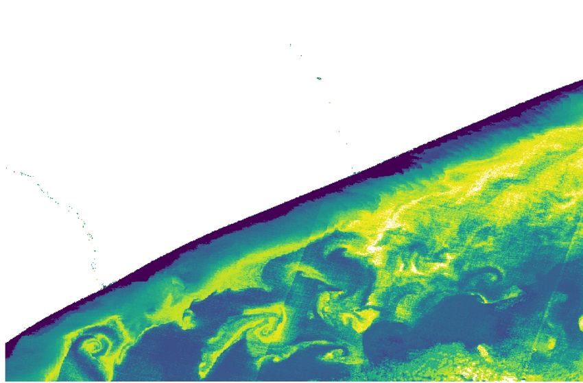
Table of contents

1 Introduction                                                                                                         2

2 The      offshore renewable       energy      industries                                                             3
  2.1      Offshore wind energy     . . . . .   . . . . . . . . . . . . . . . . . . . . . . . . . . . . . .            4
  2.2      Tidal energy . . . . .   . . . . .   . . . . . . . . . . . . . . . . . . . . . . . . . . . . . .            7
  2.3      Wave energy . . . .      . . . . .   . . . . . . . . . . . . . . . . . . . . . . . . . . . . . .           15

3 Satellite observations in the ocean                                                                                 19
  3.1 Satellite performance . . . . . . . . . . . . . . . . . . . . . . . . . . . . . . . . . . .                     19
  3.2 Satellite data processing . . . . . . . . . . . . . . . . . . . . . . . . . . . . . . . . .                     26
  3.3 Past, present and future satellite mission . . . . . . . . . . . . . . . . . . . . . . . .                      28

4 Satellite data for offshore renewable energy: synergies and innovation                          opportu-
  nities                                                                                                              34
  4.1 Satellite data to reduce uncertainties for offshore wind farm operation . .                 .   .   .   .   .   34
  4.2 Satellite data for short–term power forecasting . . . . . . . . . . . . . . .               .   .   .   .   .   34
  4.3 Satellite data for wave forecasting . . . . . . . . . . . . . . . . . . . . . . .           .   .   .   .   .   37
  4.4 Satellite data for tidal forecasting . . . . . . . . . . . . . . . . . . . . . . .          .   .   .   .   .   39
  4.5 Satellite data for environmental monitoring . . . . . . . . . . . . . . . . .               .   .   .   .   .   39

5 Conclusions                                                                                                         46

1. Introduction

     The motivation for this study arises from a need for cost reduction in the way metocean data
is typically collected in the marine environment (e.g. by using offshore meteorological stations,
which are expensive to deploy and maintain due to the harsh marine weather conditions), and how
this data gathering process affects the total cost of energy in offshore renewable energy projects.
Marine data has an impact in all phases of a marine renewable farm development, including initial
stages such as site selection and device design, but also construction (particularly during operations
and maintenance) and decommissioning. Nowadays, the planning of operations and maintenance
(O&M) missions and vessels dispatching for offshore installations is limited to updated numerical
weather forecasts every 6 to 12 hours. Being able to correctly predict, on a short–term, the weather
conditions will allow the optimisation of costs and resources for O&M. Moreover, the correct es-
timate of access windows that allow the crew to conduct the management operations safely is
difficult due to the high degree of uncertainty characterising the modelling tools currently available
for managers.

  ∗
      Corresponding author
      Email address: emedina@ed.ac.uk (E. Medina-Lopez)

                                                         2
Satellite–based measurements have long been identified as having a potential role in enabling
cost reduction of marine renewables, but applications have been largely limited to wind resource
assessment and wake modelling. This paper aims to take satellite data usage in offshore renew-
able energy (ORE) to the next level by better linking satellite data, models driven by such data,
decisions driven by the model outputs, and quantifying this impact on Levelized Cost of Energy
(LCOE). By mapping linkages between key decision horizons in ORE life cycle to satellite capabil-
ity, this paper presents a map of where satellite data can best impact ORE project decisions. This
map will direct the data analysis activities towards the project decisions having the best potential
for improvement and quantify any reductions in uncertainty. These improvements can be captured
and monetised in a range of cost models.

    Offshore climate information is derived from various key satellite datasets. Offshore wind re-
source can be derived from satellite synthetic aperture radar (SAR) for localised use, and satellite
scatterometers at a wider scale. SARs can also be used to model wave and tidal resource, and satel-
lite altimeters are specifically used for wave resource characterisation. There is a great range of
free and open satellite datasets that are relevant for ORE applications. As an example, Copernicus
Sentinel-1 is a SAR that has been operating since 2014, providing coverage over Europe, Canada
and main shipping routes in 2–4 days, regardless of weather conditions. SAR data is delivered to
Copernicus services within an hour of acquisition, Copernicus (2020). Its high resolution (20m)
allows sufficiently detailed coverage of relevant areas. The information can be download from the
Sentinel Hub online system and operated locally using the Sentinel Application Platform (SNAP)
for satellite data, European Space Agency (2020), or it can be operated online from Google Earth
Engine some days after acquisition, Google (2020), reducing operation time. The satellite–derived
information can be compared with existing numerical models and in situ measurement stations,
obtaining a quantitative comparison that is able to feed into life cycle, operations, and cost of
energy analyses.

    The paper contains three sections: the first one presents the ORE sector, describing the offshore
wind, tidal and wave sub–sectors. A brief introduction to the history of these fields is provided,
followed by current techniques for resource assessment and site characterisation, main technologies
and commercial projects, and finally by presenting the challenges of the sector. The second section
of the paper covers the satellite observations sector. An overview on available technologies and
their use is given, followed by some insight on satellite data processing and integration. The section
ends with a summary of the past, present and future of satellite missions and their applicability to
metocean observations. The last section of the paper presents the ORE and satellite data synergies,
focusing on offshore wind, tidal and wave forecasting, as well as other key parameters that can be
improved by the use of satellite data, such as environmental monitoring, physical processes in the
marine environment, fisheries, mammals and birds, and habitats. The section ends with a note on
uncertainty quantification in the use of satellite data.

2. The offshore renewable energy industries

   The current section introduces wind, tidal and wave energy, before discussing key innovation
points and opportunities for which satellite data might add significant value. Within these dis-
cussions, it will become clear that commonalities exist across different ORE sectors regarding the
decisions being made and the applications for which additional data is required. At a high level,
                                                  3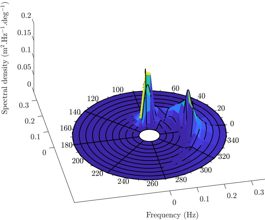
the ORE sector has been found to broadly require improved information in two contexts: the char-
acterisation of operational and environmental conditions for an offshore site and provision of data
to drive/enhance operational decision making. Each category can be broken down further into a
general framework within which key decisions across ORE technologies fit. These more detailed
breakdowns are shown in Figures 1 and 2.

                                                       Characterisation of
                                                        operational and
                                                  environmental conditions for
                                                    an offshore site or sites

                                                                                                      Filling data
                                                 Operational          Environmental
                                                                                                           gaps

                                                                          Design                        Impact
                                                                         focussed                      focussed

      Site wind, wave     Damaging effects       Salinity,           Bathymetry/                      Environmental
                                                                                        Sea-bed
     and tidal/current     - rainfall, hail,   temperature         sea-floor features               mapping/tracking of
                                                                                        mobility
          climates         biofouling etc.         etc.              and obstacles                         site

                                    Through                                             Sediment    Flora and          Habitat
                          Near                                                          transport     fauna          structures
                                     water
                         surface
                                    column

Figure 1: Graphical summary of key knowledge/decision points for offshore renewables regarding the characterisation
of operational and environmental conditions across an offshore site.

2.1. Offshore wind energy
2.1.1. Brief history of offshore wind energy
    The worlds first offshore wind farm was built in Vindeby in Denmark in 1991 Power Technology
(2020). Commercial offshore wind began to gain some momentum in the early 2000s as a reaction to
volatile fossil fuel prices and climate change, with the UK commissioning a 4MW test site at North
Hoyle in 2000 OREC (2020). This was followed in 2002 by the first large scale (>100MW) offshore
wind farm at Horns Rev in Denmark. Since then, offshore wind capacity has steadily increased
worldwide to around 30GW today. Offshore wind energy is critical in meeting the climate aims
set by 2050, although their realisation will require a more than ten-fold increase in offshore wind
power International Renewable Energy Agency (2019) compared to currently installed capacity.
As such, significant innovations and costs reductions which are sustainable in the long term are
required throughout the life-cycle of offshore wind farms UK Govt. (2019). The following sections
highlight the context for offshore wind decisions across the lifetime of a wind farm and indicate
those areas where valuable contributions can still be made.

2.1.2. Site selection
    The resource available at a site is a key parameter in determining the profitability of a resulting
wind farm. In addition, site conditions will correlate strongly to asset lifetimes, for example high
                                                               4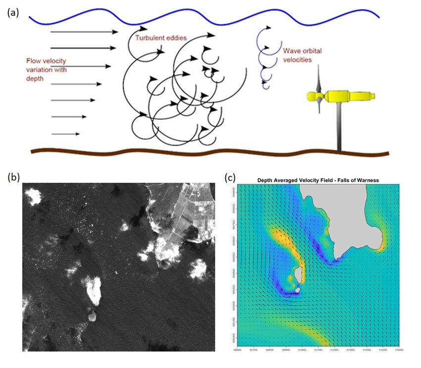
Provision of data to
                                                          drive/enhance
                                                            operational
                                                         decision making

                   Assimilation
                                                                                                            Filling data
                                                                                                                 gaps
                   Forecasting

     Short-term     Long-term          Validation                                Condition                  Operation and
                                                            ORE models
                                                                                 monitoring                    control

      Energy
      markets                                                             In-situ sensor         Yaw                        Extreme
                                                                                                            Wakes
                                                                            synergies?          errors                       events

                                  Access/scheduling              Other model                                          Device vs
                                    model inputs                    types                   Failure                 farm control
                                                     Model                          prediction/detection/
                                                    validation                            prognosis

Figure 2: Graphical summary of key knowledge/decision points for offshore renewables regarding the operational
phase of an offshore site.

levels of turbulence are associated with early fatigue related failures. As such, more detailed infor-
mation a priori about a given site allows for more accurate yield and fatigue damage assessments
to take place early in the project lifecycle. It is currently standard to assess wind conditions at a
regional level, and once a site has been chosen at that fidelity an in-situ campaign is undertaken at
the site itself Sempreviva et al. (2008). While the regional level analysis does often include satel-
lite data of some form, a clear innovation which would add value to offshore wind site selection
processes would be the possibility to survey much larger sections of ocean with increased detail
and accuracy to better identify promising sites. Furthermore, site selection is now beginning to be
considered within wider contexts which rely on availability of a range of data types Vagiona and
Kamilakis (2018), Cradden et al. (2016) and GIS software analyses, and so again there is signifi-
cant room for value to be added within these more comprehensive procedures and demanding data
requirements.

2.1.3. Wind farm design
    The design of a wind farm is a broad and complex task which ideally considers each stage of
the plant lifecycle, including: technology selection Arrambidea et al. (2019), layout and cabling
optimisation Hou et al. (2019) as well as operational and end-of-life practicalities. It should be
highlighted that this is a key stage from an overall costs viewpoint, since, decisions taken at the
design stage effectively lock-in certain cost outgoings for the full 25+ years lifetime of the wind
farm. Decisions at this stage are very much driven by past, current and future site conditions
and physical properties in terms of resource, additional environmental factors such as wave and
current loading, sub-sea features and sediment type. Within the decisions to be made, substructure
selection is a point where the project developer has strong influence since this choice is not controlled
by the original equipment manufacturer (OEM). This decision in particular is heavily influenced
                                                                   5
by environmental and geological site conditions Muskulus and Schafhirt (2015). Uncertainties
regarding site conditions currently lead to large safety factors being applied which inevitably add
costs onto projects, better information which allows for these margins to be safely slimmed down
would have important cost saving implications.

2.1.4. Construction and installation
    Offshore wind farm construction and installation requires expensive heavy lifting vessels to be
utilised, with specialist equipment for foundation construction or piling also required. The use of
such vessels is a significant costs to any project. They must be booked in advance and hence unused
operational days are still charged at the normal rates. As such, careful planning and confidence in
available weather access windows are crucial at this stage. In addition, vessels routes both to and
within the wind farm, i.e. the order of construction, must be optimised in order to avoid wasted
fuel and additional costs Barlow et al. (2015), Lacal-Aránteguia et al. (2018). Crew safety is also
of paramount importance during these phases.

2.1.5. Operations and maintenance
    The operations and maintenance phase of an offshore wind farm life-cycle is best understood as
consisting of three distinct periods, these being: in-warranty operation, post-warranty operation
and late-life operation. In-warranty operation last for the first 3-5 years once a site begins energy
production. Within this phase the owner has limited control over how the site is run, depending
on how contracts are arranged, and weather associated risks can in some cases be outsourced to
the OEM. The agreements secured in these maintenance contracts have important implications for
site yield Hawker and McMillan (2015) in the early years. Post-warranty, site operators can choose
to sign a new long term contract with the OEM, appoint a third party or bring these operations
in-house. A mixture of the above can also be used. At this stage it is crucial for the site owner
to understand the weather risks associated with operations, reliability and access. Key decisions
centre around the planning and scheduling of maintenance and repair operations throughout the
wind farm, while accounting for and managing the risks associated with weather and site condi-
tions, as well as the stochastic nature of failures Seyr and Muskulus (2019b), Shafiee et al. (2015).
Understanding and monitoring Key Performance Indicators (KPIs) is also important at this stage
Gonzalez et al. (2017). It could be argued that site conditions and weather risks for a given site
should be well known after 5 years of data collection and analysis, however, with the increasing
scale of offshore wind farms (hundreds of wind turbines covering hundreds of square kilometres
of ocean) and often only a handful of on-site met-ocean sensors, detailed site data with a high
resolution of spatial coverage is not yet a reality.

    Late-life operations, including any periods of life extension, sees another shift in context for
operational decision making. At this stage of the project, assets will be wearing out and failing with
greater frequency and inspections and repairs will be required at shorter intervals. Furthermore,
since Contracts for Difference (CfD) agreements generally have a life of 15 years, the site income
may well have changed from those under which it was designed. CfDs are contracts that guarantee
a payment for any differences between a “floor price” (below which the market price of electricity
cannot fall without a compensation made) and the actual cost of electricity to the provider. The
end stage of the CfD agreement will therefore be driven strongly by the price floor. For a detailed
overview of the key considerations and influencing factors for O&M decisions and planning see Seyr
and Muskulus (2019a).
                                                  6
2.1.6. Decommissioning and life extension
    The decisions made towards the end of the life of an offshore wind farm overlap strongly with
those made during the design phase, since, it is now necessary to reconcile assets’ operational
histories with what was assumed during planning and design. Decommissioning costs themselves
are also somewhat uncertain and so reductions in uncertainty around this is important for optimal
decision making Topham and McMillan (2016), Topham et al. (2019). Life extension of a wind
farm consists of assessing whether the assets can be safely and profitably operated beyond the
end of their design lives, a question which would be greatly assisted by improved site condition
information across the wind farm lifetime. These decisions have been fairly extensively studied in
the context of onshore wind Ziegler et al. (2018), with offshore now also being considered Bouty
et al. (2017), albeit at an earlier stage of understanding and experience.

2.1.7. Future challenges for the offshore wind sector
    Innovation points and the possible provision of information which would have significant impacts
to the offshore wind industry all centre around the provision of more data, and with improved
spatial resolutions in particular, over what is currently available regarding site met-ocean and
environmental conditions. In addition, the enhancement and increased redundancy of offshore
wind site communications provisions, for the purposes of providing ancillary services and ensuring
security of supply/blackout prevention (with respect to a future grid with much higher proportions
of renewables penetration), would also have a significant impact in this sector.

2.2. Tidal energy
2.2.1. Brief history of tidal energy
    The use of tidal energy dates back to as early as 10AD (first recorded tidal mill on the Persian
Gulf)Charlier and Finkl (2009). Early engineering applications exploited both tidal stream and
tidal range energy to turn water wheels for milling grain. Investigation into the generation of
electricity at a large scale began in the 1920s, with the world’s first tidal barrage power station
operating at La Rance Tidal range energy resource and optimization – Past perspectives and fu-
ture challenges (2018), Khare et al. (2019), France, from 1966. The La Rance barrage remains
operational, generating power through an installed capacity of 240MW. Interest on the genera-
tion of electricity from tidal stream began in the 1980’s when research into the design of tidal
hydrokinetic energy converters Bahaj and Myers (2003), Laws and Epps (2016), Borthwick (2016)
started to become mainstream. A variety of different rotor designs have been trialled, but the
sector has converged toward the horizontal axis tidal turbine (HATT), Bahaj and Myers (2003),
for the majority of applications, following the design technology developed for the wind sector. To
date power generation from tidal stream has not reached the level of tidal range systems in energy
output terms. The largest power producer from tidal stream is the MeyGen Tidal Power Project
situated in the Inner Sound of Pentland Firth, Scotland. MeyGen is currently extracting 4.5MW
through an array of four turbines, with resource consent to extend this to 86MW, SIMEC Atlantis
(2020).

2.2.2. Tidal resource assessment and site characterisation
    Tidal energy is generated by the gravitational interaction of the Earth–Moon–Sun system Gill
(1982), Pugh (1987), Apel (1988). As the relative orbital positions of these three bodies evolves,
the gravitational and centrifugal potential at the Earth’s surface varies. This leads to deformation
in fluids on the Earth’s surface; the fluid effectively bulges at nodal points in response to local
                                                 7
changes in gravitational potential - this is the tide Pugh (1987), Apel (1988). Tidal dynamics vary
in time due to the interaction of multiple forces. These tidal forces can be described by mathe-
matical expansions of harmonic constituents, a more detailed description can be found in Parker
(2007). The period difference in these forces correspond to longer spring-neap patterns, as well as
other cycles that contribute to tidal range and velocity variability. There are certain periods when
the tidal forces constructively interfere to increase the tidal range. This applies over spring tides
when the principal lunar (M2 ) and solar (S2 ) forcings complement each other resulting in greater
than average tidal ranges and velocities. The opposite occurs during neap tides when forces from
the moon and the sun counteract one-another. Moreover, other hydrodynamic effects, as ell as
wind and waves, Lewis et al. (2017), will also be relevant to the evolution of the tide, altering the
available potential and kinetic energy.

     Apart from temporal variations, tides also vary spatially. Tides are by definition ocean surface
waves of a very long wavelength λ. Despite the pronounced wavelength, they remain subject to
wave transformation including shoaling and reflection.As a progressive wave propagates from deep
water to shallower √regions (e.g. in the transition from oceanic depths to a continental shelf), the
wave celerity c (≈ gd, where d is the depth) decelerates, reducing λ and leading to an amplifi-
cation of the wave height H. In combining such changes in depth with further reflections whilst
encountering coastal features, reflected and incident tidal waves combine to form a perceived total
wave Pugh and Woodworth (2014). Consequently, the presence of landmass on the Earth’s surface
higher than the mean sea level introduces obstacles to the propagation of the fundamental tide
(i.e. the tide main component), resulting in local distortions in the tidal amplitude, phase, and
harmonic constituents Pugh (1987). It is these local distortions (for example, interactions between
islands, or narrow sea channels between land masses) that lead to the energy amplifications ex-
ploited for tidal energy extraction.

    The site information required by a tidal developer depends on the method of energy extraction
being developed, i.e. tidal range or tidal stream. Tidal range systems take advantage of local
resonance effects that amplify the available potential energy over a tidal cycle. Resonance in a
tidal basin occurs when the tidal wave period T is close to the natural period of the basin, as for
example given by Merian’s formula Pugh (1987). Effectively, the amplification of an incoming wave
is increased if the basin length converges to λ/4, assuming idealised bathymetric conditions. Such
resonance effects occur in several sites across the globe. In particular, the highest tidal range has
been observed in the Bay of Fundy, Canada where the basin natural frequency has been calculated
to be Tb ≈ 13.3h leading to amplifications Garrett (1972) for the M2 and S2 tidal wave constituents.
In the UK, equivalent conditions emerge within the Severn Estuary, known for hosting one of the
highest tidal ranges in the world. As a result both of the above have been the focus of many tidal
range energy proposals.

    Tidal stream systems take advantage of localised flow acceleration resulting from flow con-
striction (channels and straits) or flow curvature (headland effects). Such features impede locally
the propagation of the tidal waves, resulting in hydraulic gradients. The latter amplify current
velocities, and by extension the scale of the kinetic energy available. For all forms of tidal power
generation, resource assessment is typically a combination of measurement and numerical mod-
elling; this is the approach recommended in the IEC technical specification, Commission (2015),

                                                 8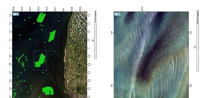
for tidal energy resource assessment and characterisation.

    Tidal range energy resource assessment initially relies on the potential energy calculation. The
maximum theoretical potential energy produced by the head difference H (m) is given by Prandle
(1984): Emax = 21 ρgAH 2 . ρ is density, g is acceleration due to gravity, and A is the impounded
surface area. Using this basis, the estimation of the global resource has been the subject of re-
cent studies (e.g Neill et al. (2018)) that employ tidal elevations drawn from available global tidal
models to quantify the head differences over every tidal cycle. While global ocean models can be a
useful indicator to provide a coherent insight to the distribution of potential energy, these models
typically lack resolution in the coastal zone and exclude critical processes such as intertidal effects.
Therefore, global approaches may not capture localised coastal details that can be vital to repro-
duce the resonance effects accurately. In refining the resource estimates for individual assessments,
regional coastal ocean models are sequentially applied to quantify with more confidence the regional
conditions Angeloudis and Falconer (2017). In conducting these processes reliably, measurements
become essential to accurately capture the tidal elevations and velocities in the areas of interest,
ensuring that the numerical approaches adequately reproduce key dynamics. In particular, for a
more informed resource and impact assessment of more developed schemes, operational models
are coupled with coastal ocean models Angeloudis et al. (2016) to simulate the individual scheme
operation and quantify and optimise the expected energy output Angeloudis et al. (2018).

    The most basic tidal stream resource assessments aims to determine how much kinetic energy
is available for extraction at a given site. The instantaneous power at a given point in the fluid is
defined Bryden et al. (2007) as Pinst = 21 ρU 3 , where ρ is the fluid density, and U is the horizontal
fluid velocity. To calculate the available tidal stream resource a 3-D map of the time varying fluid
field is required. Energy is extracted from a vertical plane in the flow corresponding to the rotor
plane of a tidal turbine. The available power is the area integral over the rotor plane of the power
from the horizontal flow normal to the rotor plane, integrated over time. The converted energy
extracted depends on the power efficiency (CP ) of a given turbine. This analysis does not take
into account the impacts of levels of turbulence, locally generated large-scale flow structures (e.g.
eddies), or local wave-current interactions. All of these processes impact on a TEC’s ability to
extract energy from the tidal stream and its long-term reliability. Therefore resource assessment
for tidal stream energy requires a full site characterisation. This informs where best to locate
turbines and turbine design parameters, as well as higher frequency loadings.

    Site characterisation is achieved through a combination of in situ measurements and regional
fluid modelling. In situ measurements are provided from a variety of instruments, the most com-
mon being the Acoustic Doppler Profiler (ADP). An ADP consists of multiple acoustic transducers
pointing in different off-axis directions, but in a geometric pattern that allows the reconstruction
of the 3-D velocities along the instrument axis. They measure the fluid velocity through the
back-scattered Doppler shift in the frequency of a transmitted acoustic pulse. Details of these in-
struments and their operation can be found in Thomson and Emery (2014), Joseph (2013). ADPs
can be deployed in fixed seabed moorings, mid-water or surface floating moorings, or from a mov-
ing vessel. In high-flow regions of interest to tidal developers, only the seabed mounted and vessel
mounted measurements are made, due to the harsh environmental conditions. Seabed moored in-
struments provide a time series of vertical profiles of the 3-D velocity at a single point. These give

                                                   9
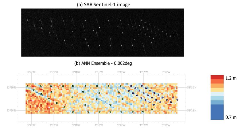
Figure 3: Site characterisation for tidal stream energy extractions needs to capture the full range of complex flow
conditions. (a) The IEC/TS62600201 2015 in situ data specifications target the capture of the vertical variation
in flow conditions, (b) but the spatial variations due to flow separation processes, as observed in satellite imagery
(Sentinel2A channel B3 data, 21/04/2017), need to be considered, (c) this is where regional-scale modelling is required
to extend the information content. The lower pannels show the EMEC research site.

high temporal data, but only the vertical flow structure at the mooring location. Vessel mounted
ADP’s can be used to survey a series of transects over multiple tidal cycles, providing good spatial
coverage at the expense of temporal resolution. To capture the full spatio-temporal variability in
the flow field, 3-D regional tidal models are required. An appropriately chosen set of ADP mea-
surements are used to validate a regional model. When appropriately configured, the ADP’s also
provide measures of the local turbulence, e.g. turbulence intensity (T I), turbulent kinetic energy
(T KE), turbulence dissipation rate (), or components of the Reynold’s stress tensor, and they
can be used to determine turbulence length scales. All of these parameters are relevant to turbine
design and reliability modelling. Lastly ADP measurements can be used to quantify the local
wave-current interactions. Wave measurements are made using the methods to be described in the
section on wave energy. At the time of writing the IEC provide technical specifications Commission
(2015) defining data collection and processing, numerical model configuration requirements, and
site characterisation reporting methods for site developers.

                                                          10
Advanced measurement methodologies are being developed to collect site data from operating
turbines Draycott et al. (2019). These techniques provide opportunities to directly assess the im-
pact of a turbine on the local flow and to complement standard measurements that have to be
made up-stream and down-stream of a turbine to minimise instrument deployment and recovery
risks. These data allow the quantification and assessment of theoretical parameters used to define
the IEC technical specifications for data capture. Local velocity field “gusts” and their impact
on turbine behaviour can be directly measured through the use of horizontally mounted ADPs.
Bespoke acoustic instruments are being designed and tested that will provide more accurate mea-
sures of the hub-height flow structures, than the standard off-the-shelf instruments can currently
achieve. The integration of such instruments on turbines may also provide a means for potential
responsive control of turbines to optimise their operation and minimise fatigue.
2.2.3. Main tidal technologies
Tidal range power plants behave effectively like dams, constructed in areas exhibiting sufficient
tidal range to economically house turbines for power generation. Their operation is based on the
creation of an artificial tidal phase difference, by enclosing water over a surface area A. This fa-
cilitates a head difference H that is then allowed to drive flow through turbines, tapping into the
potential energy. Tidal range power generation is a low-head hydropower application where bulb
turbines are currently the default turbine technology proposed and installed. Over the years, bulb
turbine capabilities have been continually evolved in terms of their efficiency Waters and Aggidis
(2016), but also in terms of their sustainability. In terms of the overall tidal power plants, while the
constituent elements between designs remain the same (i.e. Turbines, Sluice gates, Embankments),
the configuration may vary to deliver considerably different generation profiles.
Tidal range power plants can be attached to the coast (such as a barrage or a coastal lagoon)
or located entirely offshore (as offshore lagoons). ‘Barrage’ and ‘lagoon’ are terms used as per the
impoundment perimeter characteristics. If most of the perimeter is artificial, then the term lagoon
is appropriate, whilst barrage is suitable otherwise. In the case of lagoons, the additional cost
for longer embankments typically enables smaller developments, that may be more feasible than
barrages. The latter typically span the whole width of an estuary, and are thus associated with
severe hydro-environmental impacts that are challenging to quantify.
Tidal stream energy extraction is still an emerging technology, that has accelerated in recent
years due to the need to reduce carbon emissions to mitigate the impacts of energy generation
on climate change. The principles of tidal stream energy extraction are very similar to those for
wind: a rotor system is coupled to an energy converter that generates electricity which is supplied
to a power grid. The majority of marine tidal turbines being developed are horizontal axis sys-
tems. There are two mooring systems currently being investigated: fixed bed-mount systems such
as those from MeyGen and Nova Innovation, SIMEC Atlantis (2020), Nova Innovation (2020), or
floating systems, such as the Orbital Marine turbine, Orbital Marine (2020). Research to date
indicates that the fluid dynamics in tidal stream energy extraction sites are significantly more
complex than those encountered by the wind sector, therefore some of the assumptions that have
been carried across from wind may not be valid. This has tended to lead to over-engineering of
tidal turbines with an associated increase in production costs. There is a large amount of on-going
11Figure 4: General arrangement and operation of tidal range power plants. Top: the Swansea Bay Tidal Lagoon
outline of Tidal Lagoon Power Ltd, an example of a single-basin tidal range structure. Bottom: Operation of a
tidal range power plant including control parameters that can be used to optimise a tidal range structure operation
Harcourt et al. (2019).
research investigating how to provide more appropriate information to both designers and site
developers to help improve turbine performance, reliability, and maintenance. Beyond the single
12turbine systems, there is ongoing research into the design of tidal turbine arrays, in particular
turbine interaction and optimisation of power production through choice of array layout. There
is also an associated impact on both the local environment and away from the array due to the
extraction of tidal energy. These impacts are still not fully understood, and are a subject where
there is further potential to take advantage of satellite data to capture spatial changes over a wide
area.
The development of tidal energy sites is both a difficult and costly exercise, as these site
inherently have very strong and highly turbulent flows. Marine operations are limited to narrow
windows around times of slack water (i.e. there are four operating windows each day at times
of high and low water). The operating windows are further reduced by weather and waves (both
locally wind generated and open-ocean storm generated swell). For these reasons, tidal energy
extraction systems are costly to install, maintain, and operate. To be economic they must be
scalable. To achieve the necessary level of scalability high quality site information is required,
including extreme event statistics. Both short-range and long-range forecasting is required to help
minimise operational and maintenance costs.
2.2.4. Tidal projects
The majority of large scale operational projects are of the tidal range type. Up to July 2020,
the largest tidal energy producer is the Sihwa Lake Tidal Power Station in South Korea, with a
254MW capacity Bae et al. (2010). This is followed by the La Rance Tidal Power Plant, France
(240MW) OES Annual Report - 2019 (2019), Waters and Aggidis (2016). Smaller tidal range
schemes exist in Canada (e.g. the 20 MW Annapolis Royal tidal power station), Russia and China.
Moreover, there is interest in developing schemes at multiple sites where the resource allows it Neill
et al. (2018), or as solutions supporting electrification in remote/isolated areas Mejia-Olivares et al.
(2020), Delgado-Torres et al. (2020). Scotland is at the forefront of the developments in terms of
tidal stream projects. SIMEC Atlantis and the Meygen array are devising 4.5 MW of tidal stream
energy in the Pentland Firth, SIMEC Atlantis (2020). Nova Innovation is developing a tidal array in
Shetland, with a capacity of 300 kW, Nova Innovation (2020). Orbital Marine Power has developed
and tested a 2MW turbine at the European Marine Energy Centre (EMEC) in Orkney, Orbital
Marine (2020).
2.2.5. Challenges facing tidal sector
Tidal range energy technology is generally perceived as a mature form of power generation.
This is attributed to successful tidal power plant examples operating around the world, as well as
the technology transfer from hydropower and wind energy sectors, both long–established technolo-
gies. Nonetheless, there are several factors dictating the development of tidal energy schemes even
if preliminary resource assessments indicate commercial potential Neill et al. (2018). Beyond phys-
ical constraints, the capital cost and uncertainty over the environmental impacts of large marine
infrastructure constitute formidable barriers to development.
The presence of an obstruction such as a tidal range scheme can lead to earlier reflection of
the tidal wave and thus interfere with the established tidal resonance. The impact of the structure
is more pronounced for barrages that typically span the entire basin. As a consequence, the tidal
range at a regional scale can be altered, with implications for tidal fluxes, coastal inundation and
the size of intertidal areas. In the case of tidal power plants positioned along a coastline, advective
13accelerations can take place as the flow goes around the confined area Angeloudis et al. (2020).
Changes in velocity magnitude modify the shear stress exerted on the seabed, thus leading to
recirculation zones Vouriot et al. (2019) triggering erosion/deposition processes, with potentially
long-term results.
Impacts on sedimentary processes can sequentially alter estuarine and coastal water quality.
Increased sediment deposition can lead to a reduction in Faecal Indicator Organism (FIO) con-
centrations (e.g E. Coli ), thus fostering improved water quality, subject to the interaction of the
designs with the hydrodynamics and other existing marine infrastructure (e.g. sewage or desali-
nation inflows or outfalls). The increased residence time and light penetration in the artificial
impoundment could favour conditions for primary phytoplankton production. Salinity concen-
trations are likely to change, particularly in the impounded area in the presence of substantial
brackish/fresh water sources. A more extensive discussion on the water quality impacts of tidal
range developments can be found in Kadiri et al. (2012).
The main challenges facing tidal stream development are related to turbine reliability, reduction
of cost through optimal design, optimal planning of operations and maintenance activities. Reli-
ability can be improved through an improved understanding of the fluid dynamics, in particular
quantification of the large-scale structures, wave-current interactions and their effect on turbine
behaviour, and predictive control of the turbine to minimise impacts of high-frequency events. The
design of turbine rotors has a relevant impact on the operation and reliability of tidal turbines.
Blade design is informed through Computational Fluid Dynamics (CFD) modelling. The CFD
model needs to provide true representations of the full fluid environment (i.e. currents, small- and
large-scale turbulence, and waves) to capture the full spectrum of the physical loads. Operations
and maintenance is costly in the marine environment, particularly for sea bed-mounted turbines.
To date, site characterisation has been predominantly carried out using in situ measurements
and numerical models, but satellite data provide regional scale data the can be used to both
characterise a site and validate numerical models. In particular, optical and SAR imagery can
be used to quantify the large-scale eddy fields generated by flow separation processes. These
data potentially provide another independent measure that can be used to validate numerical
simulations, and provide a first pass indication of regions within a site that may be problematic
both for in situ data collection for site characterisation and for subsequent positioning of tidal
turbines. Optical imagery generally provides high spatial resolution (¡10m), but the information
content is limited by the amount of cloud in a given image. This significantly reduces the number of
useful images available for a given location from a time series. SAR imagery is not restricted by the
presence of cloud and the spatial resolution is improving with each generation of instrument. With
an appropriately configured SAR system it has been shown that surface currents can be measured
from space Joseph (2013), Romeiser et al. (2014), Suchandt and Runge (2015). These techniques
need development to allow full 2D surface-velocity fields to be derived, but has the potential to
provide maps of surface flow data. Altimeter data are used to validate tidal models, but currently
these data do not provide sufficient spatial resolution or accuracy in straits and channels typically
targeted for tidal stream energy extraction. The more general limitation of satellite data is the
frequency of over-passes at any given site, which is generally twice daily or less, but there is the
potential to build a statistical picture of temporal variability from long-time series of satellite data.
142.2.6. Future of tidal energy
For tidal range energy, there are a number of schemes that are under consideration over the
next 5-10 years, and many more sites have been identified around the globe where schemes can be
developed. The main barrier to the development of these types of systems is generally related to
environmental impacts as well as making a robust case for the initial capital investment. For the
latter, satellite data can play a role in more adequately addressing uncertainties associated with the
environmental impact and also informing future studies about regional and far-field effects of tidal
range schemes.For tidal stream, increased commercial investment is required, most of the current
focus is on small scale projects that service islands or integrate with a range of renewable energy
sources. Reliability is a key factor identified as introducing high-risk to investors, so significant
development is needed to accelerate methods for improving reliability. This depends on design
improvement, materials, turbine siting, resource characterisation, predictive control (impact of
waves, storms, etc), and O&M optimisation.
2.3. Wave energy
2.3.1. A brief introduction to wave energy
Over many years, significant research, development and innovation has been carried out across
the world looking at wave energy technologies. The first recorded attempt at devising a concept
to harness wave energy goes back to 1799 when two French engineers patented a system involving
a float and a lever (Ross, 1995). There is however, no knowledge of the outcome of this invention.
The next notable use of wave energy was in the 1950s to power navigation buoys around the coast
of Japan. These buoys were produced on a relatively large scale (about 300 were deployed) but
the amount of energy each buoy produced was relatively small (just enough to power a 60W nav-
igation light). Modern research and development in wave energy as a means of producing utility
scale electricity was motivated by the oil crisis of the early 1970s. New government programmes,
particularly in the UK, encouraged research, including pioneering work of Prof. Stephen Salter and
his team at the University of Edinburgh (Salter, 1974). Since then, over 85 wave energy converter
(WEC) concepts have been tested at large-scale and under representative environmental conditions
Babarit (2017), but so far, no long lasting commercial breakthrough has been achieved. Through
changing programmes at different levels of government, support for technology development was
intermittent and progress slow Hannon et al. (2017). At the same time, other forms of renewable
energy have been progressing quickly, taking some focus off the developments required to push
wave energy technology forward. As a results, some technology developers are now focusing on
niche markets such as powering remote island communities, oceanographic instruments and iso-
lated offshore oil and gas equipment, where traditional power generation approaches are costly
and/or difficult to implement technically LiVecchi et al. (2019).
Over the course of wave energy development, a wide variety of methods have been explored in
an effort to extract the energy from waves. Each of these methods has tried to exploit different
features of the wave energy resource. Some methods rely on the rise and fall of a wave moving
a floating device, others rely on the change in pressure above a submerged device, while another
method extracts energy from the surging motion of waves before they break close to shore. The
Aquaret project Aquaret (2020) gives descriptions and graphics describing the most common types
of WECs, each one designed around different features of the wave resource. Details relating to the
performance of device types in different sites using a variety of evaluation metrics can be found in
15Babarit et al. (2012).
A key performance indicator to assess the future potential of a WEC technology is the long
term LCOE. Three key elements of this calculation are: the initial capital cost of the wave energy
device/array, the operations and maintenance costs, and the revenue generated from output. Each
of these elements are influenced at different stages of the project development lifecycle. The
capital expenses can be considered to be loosely related to the historical site conditions, and
the structural design of the WEC. Operations and maintenance (O&M) costs can be minimised
through design and planning but will be influenced by the site conditions at the time the O&M
operations are required. Indeed downtime for maintenance can be planned during periods when
lost revenue would be minimised either based on analysis of historical data or forecasts of future
conditions. Prediction of future revenue will be based on calculations of historical wave resource
information and knowledge of device performance, but can be broken-down to seasonal revenue
based on resource variations. Accurate assessment of the LCOE throughout the development stages
of a WEC concept is key to assess its commercial viability and inform design decisions.
2.3.2. Wave energy converter site characterisation
The features of a site which are of interest to the developer of a WEC include, but are not lim-
ited to, seabed bathymetry and ground conditions, tides and currents, wave resource (wave heights,
wavelengths, range of wave directions and spectral information), marine life and wind conditions.
Other characteristics of the site which may be of interest depending on the type of WEC are water
depth changes based on tidal range or variation between regular conditions and storm conditions.
There are a range of instruments and methods available to determine some of these features which
include in situ measurement, numerical models and human observations. Each of these has their
own advantages and disadvantages which include cost and accuracy, so the best compromise is
often used for practical reasons. When technology starts to reach a higher level of maturity it is
required to test a prototype at sea, and this is often undertaken at a scale which is smaller than
the expected commercial device. The process to determine an appropriate open water site for a
scaled device is not straightforward and detailed analysis of both the commercial deployment site
and the scale test site is required Mclean et al. (2019).
Improving the accuracy of available data for the site, including the wave resource, is imperative
to optimise the design of the technology and the commercial array in which it is to be used. Re-
gardless of the feature of the wave resource being exploited by the WEC, accurate representation
of that resource is required. Seasonal and annual variations at a site can be significant Perignon
(2017), Mclean et al. (2019) so extensive knowledge of a deployment site is important at a number
of stages throughout the development of a WEC and a commercial project. During design phases
it is important to understand the wave conditions and how this will impact on the device motions
and loads within individual components. The International Electrotechnical Commission (IEC),
recommends, in its technical specification on wave energy resource and characterization Interna-
tional Electrotechnical Commission (2015), fully spectral and directional description of the seastate
for WEC design, as well as understanding of the extreme conditions at site in order to determine
design load cases International Electrotechnical Commission (2019). This detailed level of resource
description can be achieved by in situ physical measurements or by hindcast numerical modelling.
In situ measurements can be obtained from a range of instruments. The most common ones are
listed below with a short explanation and a more comprehensive list, with more details on their
16working principle can be found in (Tucker and Pitt, 2001, chapters 3-4) and (Pecher and Kofoed,
2017, chapters 3).
Surface-following buoys are equipped with accelerometers and/or GPS sensors from which wave
elevation time series and spectral measurements can be inferred. These instruments are typically
expensive (although new GPS buoys are becoming more affordable Raghukumar et al. (2019)).
They are well-suited for deep water sites and have a well-established track record (less so for the
GPS based ones which are more recent). Their main limitation is measurements where currents
are present and steep waves as the buoys does not accurately follow the water surface. Directional
and non-directional surface-following buoys are available. Regular removal of marine growth may
be required to ensure measurement accuracy is not impacted by the change in weight or drag of the
buoy. Acoustic current profilers are instruments that can be deployed on the seabed and which rely
on transducers emitting acoustic pulses which are reflected by the water surface and by particles
in suspension in water. The former phenomenon allows surface tracking while the latter allows
measurements of particle velocity throughout the water column using the Doppler effect Work
(2008). As their name implies, these instruments were originally designed to measure current but
omnidirectional wave elevation can be measured from surface tracking while directional wave mea-
surements can be inferred from water particle motions. These instruments tend to be expensive
and suited for shallow water wave measurements. Pressure transducers are also deployed on the
seabed. The pressure measurements they provide is used to infer the water level variations due to
tide but also to waves. They tend to be less expensive but the quality of the wave measurements
obtained is affected by the wave induced pressure decay with water depth which make them only
suitable for shallow water sites. They only provide omnidirectional wave measurements except if
they are deployed in arrays Howell (1998).
Numerical modelling of wave energy resource is typically achieved using third-generation spec-
tral models such as SWAN or WaveWatch. These solve the wave action balance equation Hassel-
mann et al. (1988) on a grid which discretise the ocean domain of interest. More information about
this is provided in section 4.3. Physically, this balance equation can loosely be assimilated to the
energy balance of waves, where the wind blowing over the ocean surface is the main energy source
and white capping, wave breaking and bottom friction are the main energy sinks. Moreover, the
model takes into account non-linear energy transfer between different wave frequencies. The way
some of these phenomena are modelled is semi-empirical and the model therefore requires calibra-
tion against in situ measurements. It is not always possible to have location overlap between in
situ measurements, accurate spectral model data and desired WEC deployment sites, however it
may be possible to use one buoy to calibrate a wave model at one precise location, then expand
the area of acceptable accuracy based on satellite data. Figure 5 shows a representation of the fre-
quency and directional spectrum obtained from the public domain wave climate hindcast Homere
database (Accensi and Maisondieu, 2015) produced by IFREMER.
2.3.3. Wave climate forecasting
To optimise a WEC and an array, real time knowledge of the incoming wave can be used as
an input to a control system to update system settings, Li et al. (2012). The optimisation may be
designed for maximising power output, smoothing output across the array or intended to reduce
wear on components.
17Figure 5: Frequency and directional spectrum at 47.239◦ North; 2.786◦ West (off the coast near Nantes, France).
Short term forecasting can also be used to estimate the output of the array, providing more
accurate information to grid operators and analysts looking to balance the national grid. Balancing
the grid is an issue for all electricity generators and research is ongoing, Barlow et al. (2015), Drew
et al. (2017), Cannon et al. (2017), looking at the issues and solutions available to the sector to
prevent curtailment, blackouts or large energy price fluctuations due to intermittent generation.
It is proposed that predictable electricity generation may have a higher value than intermittent
generation due to ability to plan grid balancing activities rather than having to react to sudden
changes, Pennock et al. (2019).
Slightly longer-term forecasts can be used for planning of marine operations where wave height
or wind speed will limit the opportunities for undertaking work. Some operations may only take
a few hours, while others a few days, and depending on the availability of vessels, equipment
and personnel, they may need to be kept on stand-by waiting for appropriate weather windows.
Improved accuracy for site condition forecasts can improve the planning of marine operations,
reducing the stand-by time and therefore reducing costs. This may be more important when
equipment within the WEC has failed and there may be safety risks associated with such operations
being delayed.
2.3.4. Future perspectives and challenges
A combination of historical and current environmental data can be used to determine migra-
tion routes for marine mammals and assess if there has been a long term impact on this by the
presence of a wave energy array in a particular area. It is recognised that by creating a fishing
18exclusion zone within the array, it may displace marine life, even encouraging them to migrate to-
wards the array. This, in itself is an interesting topic for which there is a lack of long term realistic
data within the ocean energy sector, but possibilities of further research in the future are extensive.
Accurate site data, used for hindcast, real-time and forecasting is imperative to improve the
design, optimisation, planning and long term operations of ocean energy technologies. As such,
all methods for providing this data should be explored including how existing practices can be
complimented and improved with satellite data. Satellite data could be a tool to help calibrat-
ing/validating hindcast wave resource numerical models. Indeed, although satellites would only be
able to provide significant wave height and a wave length/period parameter at one particular time
per day, this can be done over a wide area unlike what is available from conventional in situ wave
measurement (surface-following buoys, acoustic Doppler profilers).
3. Satellite observations in the ocean
3.1. Satellite performance
Different sensors are used within the field of satellite oceanography research. These sensors can
be classified according to their range of measurement within the electromagnetic spectrum Preiss-
ner (1978). The performances of remote sensing instruments take place between certain wavelength
(or frequency) ranges of the spectrum. Thus, optical sensors operate within the visible wavelength
range, 0.4 to 0.7 µm and the near infrared range between 0.7 µm and 1.1 µm. Infrared (including
thermal) measure between 1.1µm and 1 mm. Finally microwave sensors use wavelengths between
1 mm and 1 m (300GHz – 300 MHz). Atmospheric attenuation due to clouds, rain, snow, or water
column varies according to the relative size of the attenuating features and the selected wave-
length. Thus, optical and infrared signals are more affected by the meteorology than microwave
signals which are much longer in wavelength and therefore scatter much less. Longer wavelength
microwaves are typically therefore not altered by clouds, but can be disturbed by rain, especially
at the shorter wavelengths used by many satellite radar systems. Sensors can be designed as mul-
tispectral, while others operate at specific wavelength. Multispectral instruments can operate at
different wave bands (referred to as “bands” as shorthand).
Another classification according to instrument performance is passive and active operation.
Passive sensors are signal receivers, but do not transmit any electromagnetic pulse. These sensors
can measure radiance, thermal emission, and scattered energy that originates from some other
source, such as the Sun. On the other hand, active sensors illuminate the planet surface with an
electromagnetic pulse and measure the ’backscattered’ signal of that pulse after it has scattered
from features on the surface (Woodhouse, 2005, chapters 1). Optical and infrared sensors are
passive instruments, while microwave sensors are divided between passive and active instruments
(radar).
Along with passive and active designation, sensors can also be classified as sounders or imagers.
Sounders, also known as atmospheric sounders, measure vertical distributions of atmospheric pa-
rameters, such as temperature, humidity, precipitation and chemical composition. Infrared sensors
are the most common atmospheric sounders, although microwave sounders are also in use. On the
other hand, imagers measure two dimensional properties in a plane parallel to the surface. Optical,
microwave, and infrared sensors can be used as imagers. Currently all the Earth Observation (EO)
19You can also read