SECONDARY GEODIVERSITY AND ITS POTENTIAL FOR URBAN GEOTOURISM: A CASE STUDY FROM BRNO CITY, CZECH REPUBLIC
←
→
Page content transcription
If your browser does not render page correctly, please read the page content below
Lucie Kubalíková, Karel Kirchner, Aleš Bajer
QUAESTIONES GEOGRAPHICAE 36(3) • 2017
SECONDARY GEODIVERSITY AND ITS POTENTIAL FOR URBAN
GEOTOURISM: A CASE STUDY FROM BRNO CITY, CZECH
REPUBLIC
Lucie Kubalíková1, Karel Kirchner1, Aleš Bajer2
Institute of Geonics, Academy of Sciences, Brno, Czech Republic.
1
2
Department of Geology and Pedology, Faculty of Forestry and Wood Technology, Mendel University in Brno,
Czech Republic
Manuscript received: April 15, 2017
Revised version: July 01, 2017
Kubalíková L., Kirchner K., Bajer A. 2017. Secondary geodiversity and its potential for urban geotourism: a case study
from Brno city, Czech Republic. Quaestiones Geographicae 36(3), Bogucki Wydawnictwo Naukowe, Poznań, pp. 63–73.
7 figs, 1 table.
Abstract: Secondary geodiversity (represented by anthropogenic landforms, which can be considered a significant part
of geoheritage of certain area) can be seen as an important resource for geotourism and geoeducational activities with-
in urban areas. Brno city (Czech Republic) is rich in these landforms as well as numerous urban areas. Some of them
(especially old quarries and underground spaces) are already used for recreation, tourism and leisure or they serve as
excursion localities for the university students, some of them are unique from the geoscience point of view and they
have also certain added values (historical, archaeological or ecological). However, in some cases, their potential is not
fully recognised. The article describes the main anthropogenic landforms within Brno city and analyses their suitability
for geotourism and geoeducational activities.
Key words: geosites, geodiversity, anthropogenic landforms, recreation, geoeducation
Corresponding author: Lucie Kubalíková, LucieKubalikova@seznam.cz
Introduction
This definition presents the geodiversity as val-
ue-free quality of the natural environment; those
Geodiversity, respectively its valuable part – elements of natural geodiversity that are of signifi-
geoheritage is undoubtedly the main resource cant value to humans for non-depleting purposes,
for the geotourism and geoeducational activi- which do not decrease their intrinsic or ecological
ties (Dowling, Newsome 2010, Dowling 2011). values are called geoheritage (Sharples 2002). The
Geodiversity is defined as “the natural range (di- concept of geoheritage is based on the definition
versity) of geological (rocks, minerals, fossils), ge- of natural heritage, which was presented already
omorphological (landforms, topography, physi- in 1972 (UNESCO 1972). The term geoheritage
cal processes), soil and hydrological features. It was defined as those components of natural geo-
includes their assemblages, structures, systems diversity of significant value to humans, includ-
and contribution to landscapes” (Gray 2013: 12). ing scientific research, education, aesthetics and
© 2017 Author(s)
This is an open access article distributed under
the Creative Commons Attribution-NonCommercial-NoDerivs license
doi: 10.1515/quageo-2017-0024
ISSN 0137-477X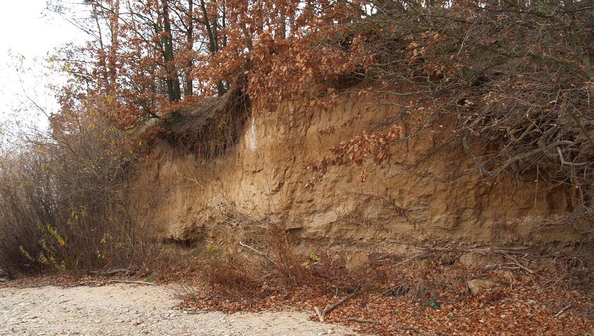
64                             Lucie Kubalíková, Karel Kirchner, Aleš Bajer

inspiration, cultural development, and a sense of     including scientific research, education, aesthet-
place experienced by communities (Dixon 1996 in       ics and inspiration, cultural development, and a
Dingwall 2005: 14). A similar definition was pre-     sense of place experienced by communities.
sented by Eberhard (1997); he emphasised that
geoheritage belongs to the “things we would wish
to retain for present and future generations”.        Secondary geodiversity represented
    In the above mentioned definitions of geoher-     by anthropogenic landforms
itage appears the word “natural” (natural geodi-
versity or primary geodiversity, that means the          Those components of secondary geodiversity,
features formed without the human impact or ac-       which form the part of geoheritage, are generally
tivity). Obviously, the natural features represent    represented by anthropogenic landforms (or man-
the greatest part of geoheritage (both on glob-       made landforms). They can be sorted by using
al and local scale), but the secondary (or man-       various criteria, but for the purposes of this pa-
made) geodiversity should not be omitted as it        per, the genetic classification is probably the most
also represents a significant resource for tourist    suitable. The following classification is based on
and recreation activities (Kubalíková et al. 2016).   Kirchner, Smolová (2010) and Szabó et al. (2010):
    Secondary or man-made geodiversity can be         1) mining landforms (quarries, pits, collapse
defined (analogically to the Gray’s definition of        sinks, subsident depressions, dumps, heaps,
geodiversity) as “the range/diversity of the man-        shafts, adits etc.),
made/anthropogenic landforms, including their         2) industrial landforms (industrial fields, heaps,
assemblages, relationships, structures and sys-          underground factories etc.),
tems”. As well as natural (or primary) geodiver-      3) agricultural landforms (agricultural terraces,
sity, the secondary geodiversity has the potential       piles, ramparts etc.),
for geotourism and geoeducational activities          4) urban landforms (terraces, ramparts, waste
both outside and within urban areas. There is a          dumps, urban underground, emergency shel-
lot of examples, where the secondary geodiversi-         ters etc.),
ty increases overall geodiversity of certain areas    5) communication landforms (road or railway
(e.g. limestone quarries in the Bohemian Karst).         cuttings, transport platforms etc.),
The secondary geodiversity also allows us to          6) water system landforms with a subset of lit-
know the information which would normally re-            toral landforms (water reservoirs, dams, pol-
main hidden and so it helps to understand the            ders, water canals, mill races, weirs, wells etc.),
evolution of landscape and Earth history, e.g.        7) military landforms (craters, ramparts, fortifi-
Klonk near Suchomasty, where the boundary be-            cation systems, underground bunkers etc.),
tween the Silurian and Devonian period was un-        8) funeral landforms (funeral hills, burial
covered thanks to the quarrying and then it was          mounds, crypts, tombs, ossuaries etc.),
ratified as a Global Boundary Stratotype Section      9) celebration landforms (menhirs, dolmens,
and Point in 1972 (Chlupáč et al. 1972).                 cromlechs etc.),
    In the Czech Republic, the term “secondary        10)		other landforms (recreational landforms, ar-
geodiversity” was introduced by Cílek (2002)             chaeological excavations, research landforms
who encompassed its role in the diversity of the         etc.).
landscape in wider meaning. So, specific anthro-         Probably the most attractive landforms from
pogenic landforms (which represent particular         the geotouristic and geoeducational point of view
features and examples of geoheritage) form the        are the mining landforms (quarries, pits), urban
full-value and indisputable part of the geoherit-     landforms (underground, artificial caves) or com-
age both on global and local level.                   munication landforms (road or railway cuttings).
    If the statements mentioned above are accept-     However, the analysis of the attractiveness of the
ed and taken into account, a slightly modified        specific types of anthropogenic landforms and
definition of the geoheritage can be presented:       the validation of the attractiveness of the above
components or features of primary (natural) and       mentioned would require detailed research,
secondary (man-made or anthropogenic) geodi-          which should include more anthropogenic fea-
versity, which are of significant value to humans,    tures within larger areas and which should use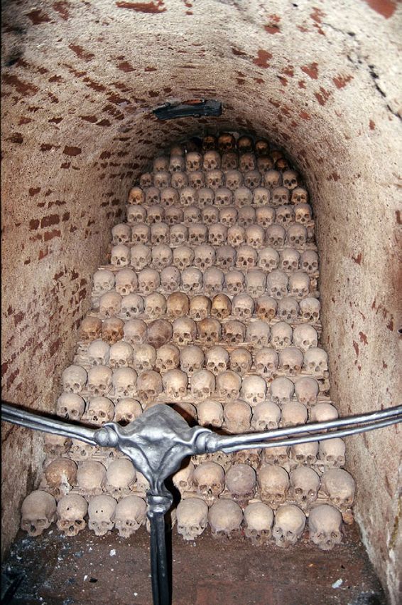
Secondary geodiversity and its potential for urban geotourism: a case study from Brno city        65

the statistic methods and particular assessment of      forming the basement, is covered by the Neogene
the geoeducational and geotouristic potential.          sediments of the Carpathian Foredeep. Brno
   The secondary geodiversity is also represent-        Massif is the Cadomian magmatic body (570–600
ed by anthropogenic processes and influences            Ma old) composed of the Eastern and Western
on the relief, especially removing large volumes        Granodiorite Area, which are separated by the
of material and the processes which would not           Metabazite Zone composed of slightly meta-
normally exist on certain place: formation of de-       morphosed basalts with geochemistry similar
bris cones in quarries, littoral processes on the       to basalts of mid-ocean ridges. This is the oldest
shores of the artificial lakes etc. The observation     proved part of the Brno Massif (~725 Ma old).
and the explanation of these processes can also             The Paleozoic cover is represented by
have interesting geoeducational and geotouristic        Devonian basal clastic sediments, which crop
potential as they help understanding the creation       out in a tectonic slice of the Babí lom zone (e.g.
of anthropogenic landforms.                             Červený kopec, Žlutý kopec), and Devonian
                                                        limestones, which can be found especially on the
                                                        northeastern part of the city (e.g. Hády).
Study area                                                  In a few isolated cases in the southeastern part
                                                        of the study area, the Jurassic limestones occur
    The Brno city is the second largest city in         (e.g. Stránská skála).
the Czech Republic (population: approximately               The Neogene sediments of the Carpathian
380,000 inhabitants) and it is situated in the South    Foredeep cover the Brno Massif preferentially
Moravian Region (southeastern part of the coun-         along the tectonically predisposed valleys. The
try) (Fig. 1). It lies on the contact of the Bohemian   Ottnangian gravels prevail in the north part of
Massif and Carpathian Foredeep, which makes             the city (e.g. Jinačovice trough). The Řečkovice–
the geology and geomorphology arrangement               Kuřim trough (northern part of the study area)
of the area quite complicated and varied. The           is filled by the thick Badenian calcareous clays
following description of the geological and geo-        with sands and gravels at the base, which can be
morphological settings is based on Novák et al.         found also in the southern part of the study area
(1991), Müller, Novák (2000), geological maps           under the Quaternary loess and fluvial deposits.
and information available on the web page of                There is currently no active mine or quar-
the Czech Geological Survey (2017a, 2017b) and          ry, but the exploitation of construction material
Demek, Mackovčin (2014).                                (building stone, loess) can be traced back to the
    The Brno Massif (part of Brunovistulicum)           14th century and it has markedly influenced the
and its Paleozoic cover (Moravian–Silesian area)        landscape. The most important limestone quar-
                                                        ries are situated on the Northeast of the city
                                                        (Hády, Lesní lom), diorite was extracted e.g. in
                                                        the northwestern part of the study area, and the
                                                        loess and sands were exploited in the southern
                                                        part of the city.
                                                            The study area belongs to two different ge-
                                                        omorphological provinces: Czech Highlands
                                                        (northern and central part of the study area)
                                                        and Western Carpathians (southern part). In the
                                                        northern and central part, the relief is tectonical-
                                                        ly influenced (occurrence of horsts and grabens
                                                        and tectonically conditioned valleys of Svratka
                                                        and Svitava) and more pronounced (significant
                                                        elevations – Petrov, Špilberk, Kraví hora etc.),
  Fig. 1. The position of the study area (Brno city)    the southern part is rather flat and it was formed
  within the South Moravian region and the Czech
                      Republic.
                                                        especially during the Neogene and Quaternary.
 Source: http://navstevapapeze.cz/_d/mapa_jmk.jpg,      The relief of the study area is strongly influenced
           accessed 29.06.2017, and modified.           by the anthropogenic activity.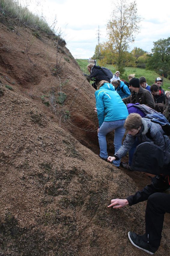
66 Lucie Kubalíková, Karel Kirchner, Aleš Bajer
Selected sites Hády plain has monotone substrate
(Vilémovice limestone of Devonian age) rugged
In this section, some selected geosites and ge- by small quarries which can be confused with
omorphosites of anthropogenic origin potential- natural landforms (especially sinkholes). These
ly interesting for geotourism and geoeducational depressions have been there already since the
activities within Brno city are briefly described Middle Ages. They have an important role for the
(Fig. 2). The list is not exhaustive, and the main local ecosystems (especially thermophilic vegeta-
criterion for the selection was to identify the tion) and they increase the overall biodiversity of
sites which would represent the highest number the area.
of genetic groups of anthropogenic landforms The upper bench of the Hády quarry is impor-
mentioned above. The information is based on tant from the stratigraphic and palaeontological
fieldwork, Database of the geological localities point of view. The transgression of the Jura lime-
(Czech Geological Survey 2017b), Kubalíková et stones (palaeontologically rich: ammonites, bele-
al. (2016) and other resources (cited below). mnites, crinoids, brachiopods, sporadically teeth
of sharks) on the folded Devonian limestones is
1 – Hády well visible here (Fig. 3a).
Hády quarry includes three different sites: In the lower part of the Hády quarry (Růženin
Hády plain, the upper bench of the limestone lom), the tectonic thrust of the older rocks of Brno
quarry and the lower part of the quarry (Růženin Massif on the younger Upper-Devonian and
lom). Lower-Carbon limestones of the Líšeň formation
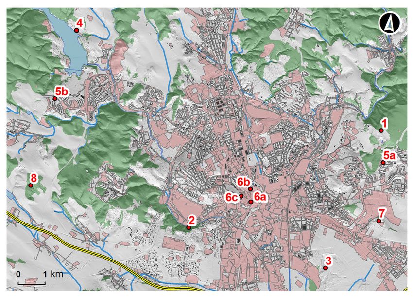
Fig. 2. A sketch of the position of the selected sites within the study area.
1 – Hády, 2 – Červený kopec, 3 – Pískovna Černovice, 4 – Abrasion cliffs on Brno dam, 5a – Jedovnická Street cutting,
5b – Vejrostova Street cutting, 6a – Labyrinth under Zelný trh, 6b – Ossuary under St. James Church, 6c – Shelter
Z-10, 7 – Stránská skála, 8 – Bosonožský hájek.
Source: https://geoportal.gov.cz/web/guest/home, accessed 29.06.2017 and modified.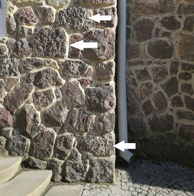
Secondary geodiversity and its potential for urban geotourism: a case study from Brno city            67

Fig. 3. (a) The transgression of the Jura limestones on the folded Devonian limestones in the upper bench of the
  Hády quarry, (b) The bottom of the Hády quarry (Růženin lom) flooded with a lake; in the background, the
   alternation of limestone, clay limestone and calcic claystone can be observed (Photo: L. Kubalíková, 2015).

can be observed. Also the alternation of lime-           quarries where the Lower-Devonian conglomer-
stone, clay limestone and calcic claystone is visi-      ate was extracted. The conglomerate has a typical
ble together with other facies that reflect the tur-     red-violet colour which gave the name to the site
bulent sedimentation.                                    (Červený kopec means Red hill) and it presents
    Concerning the anthropogenically condi-              an illustrative example of the basal clastic sedi-
tioned processes, it is possible to observe the for-     ments and of the sedimentation environment,
mation of debris cones (both in the lower and up-        so it has a high educational value from the lith-
per part of the quarry), which has a remarkable          ological and palaeogeographical point of view.
geoeducational potential.                                The stone was extracted since the Middle Ages
    The bottom of the quarry is flooded by a lake        and it was widely used as dimension stone; it
(Fig. 3b) which is important from the ecological         can be found in the various walls and buildings
point of view; halophyts and steppe species can          within Brno (Fig. 4). The second site is a former
be found here.                                           loess pit (former Kohn’s brick-kiln) where the
    The site is well accessible, there are several       loess profile with fossil soils is preserved. The
marked paths in the area and an educational trail
about the natural features. The site is also widely
used as an excursion locality for university stu-
dents. This complex of anthropogenic landforms
is a good example how the overall geodiversity
and biodiversity can be increased by the human
action and how the anthropogenic landforms can
serve the educational and recreational purposes.
    Close to this geosite, a new recreational zone
is proposed – it should have the character of a
park (according to the land-use plan of the Brno
city) with possibility of sport activities. At pres-
ent, the competition of proposals (architecton-
ical-landscape plans) is running. The question
is if the park will raise the attractiveness of the
geosite.

2 – Červený kopec
   There are two geologically and geomorpho-
logically different localities within Červený             Fig. 4. Old Red conglomerate used as building stone,
kopec. The first one is the system of old small                   Biskupská Street (Photo: A. Bajer, 2017).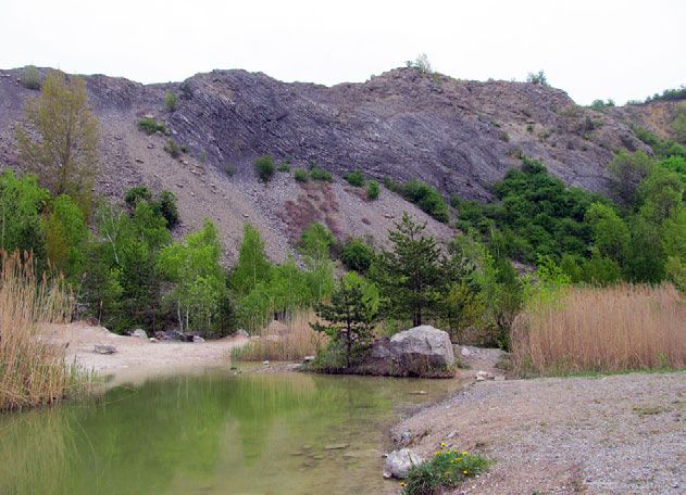
68                               Lucie Kubalíková, Karel Kirchner, Aleš Bajer

site is stratigraphically important and unique in         site has a big educational potential, but it is acces-
Europe, because it shows the whole Quaternary             sible only with permission after previous consul-
evolution (approximately 2 Ma). Thanks to the             tation of the owner (the land is private and sand
presence of this complex profile, the site has an         extraction is still in progress). Usually, the access
immense educational and scientific value (being           for organised groups (e.g. university students) is
the topic of a considerable number of scientific          possible.
papers, e.g. Kukla 1975, Musil 1982, Smolíková
1990, Zeman 1992, Demek et al. 2005). Both sites          4 – Abrasion cliffs on Brno dam
are well accessible and visible, although the sec-            Brno dam was constructed in the 1930’s and it
ond one partly suffers from vegetation growth.            considerably changed the relief of the area. The
                                                          most remarkable form is the body of the dam
3 – Pískovna Černovice                                    itself (23.5 m high, 120 m long, 7 m wide), but
   The active sand pit of Černovice is important          there are other relevant anthropogenic features.
especially from the stratigraphical and palaeon-          Probably the most interesting and attractive ele-
tological point of view. During the extraction            ments are the abrasion cliffs formed thanks to the
of the material, the sediments of Tuřany terrace          activity of the waves on the shores caused espe-
were displayed. They lies 40 m above the pres-            cially by winds and also by shipping (Šlezingr
ent-day level of the Svitava river and they are           1998, 1999 in Peterková 2011). They are developed
formed by sand and gravel with pebbles of var-            on the locality of Osada in Quaternary loess sed-
ious provenance. Below this terrace, embedded             iments and they reach the height of 4 m (Fig. 5).
Brno sands are present. These sands were formed           These landforms are a good example of dynamic
during the LowerBadenian marine transgression             geomorphological processes on coastal environ-
and they include concretions of calcareous sand-          ments. The cliffs have also an ecological value as
stones or sandy limestones that form the bench-           they serve as a nest place for various bird species
es, probably the residues of beach sediments.             (sand martin, king fisher). The site itself is well
They are also palaeontologically rich (especially         known, visible and accessible, the landform is
shallow water taxons, e.g. Ammonia beccarii). The         quite illustrative and the ecological feature is also
sediments of the Černovice sand pit represent the         attractive, but the geotourist and educational po-
deposits of the Outer Carpathian Foredeep. The            tential of this site is not fully recognised and used.

     Fig. 5. Abrasion cliff developed in Quaternary loess on the Osada, Brno dam (Photo: K. Kirchner, 2015).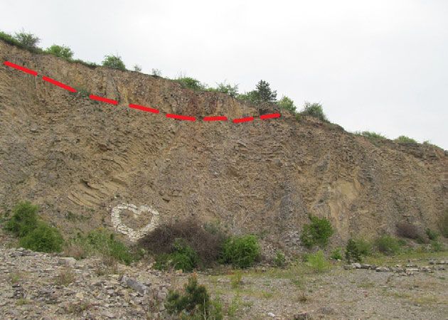
Secondary geodiversity and its potential for urban geotourism: a case study from Brno city            69

5 – Jedovnická Street cutting (Líšeň)                      the position of Brno Massif’s rocks in the regional
and Vejrostova Street cutting (Bystrc)                     context and can serve as field geology textbook.
    On Jedovnická Street several rock profiles of             Both road cuttings are a good example of
Brno Massif’s granodiorites (type Královo Pole)            communication landforms. Generally, the road
are example of road cuttings. The rock profiles            cuttings have a big educational potential and
are mostly heavily weathered, pinkish to red-              there is a lot of similar landforms within Brno,
dish, with brown discolouring due to weath-                however, some of them exist only temporarily
ering, medium to coarse-grained biotitic gran-             and there is often no time to do a description or
odiorites. Spectacular ones are up to 2 cm long,           documentation.
bronze-brown, columnar (pseudohexagonal) bio-
tites. Within the slope debris of this road cutting,       6 – Anthropogenic underground of Brno
the biotite can be very easily found and collect-          (Labyrinth, Ossuary, Bunker Z-10)
ed, which has a significant educational potential             The underground spaces underneath Zelný
(Fig. 6).                                                  trh (market) have been created since the Middle
    On the right side of the Bystrc housing es-            Ages. The complex of cellars served for food
tate, on Vejrostova Street, there are visible              storing, ageing of wine and beer, as war shelters
road cuttings in rocks of Brno Massif’s mantle.            and mainly as a background for the marketers
Differently tectonically affected gneiss, accom-           (the markets on the Zelný trh have been held for
panied by younger granodiorites of Brno Massif             more than 700 years). In 2009, the cellars and oth-
(type Tetčice) and even younger veins of aplite            er underground caverns were reconstructed and
can be observed here. The profile clearly shows            nowadays they are one of the tourist attractions
                                                           of the Brno city. From the geoeducational point
                                                           of view, the Labyrinth underneath Zelný trh is a
                                                           good example of urban underground with high
                                                           historical, cultural and archaeological value.
                                                           The accessibility is good and the site itself is safe
                                                           (Svoboda 2008).
                                                              Another example of anthropogenic under-
                                                           ground (or more accurately funeral under-
                                                           ground landform) is the Ossuary under the St.
                                                           James’ Church (Fig. 7). The number of buried
                                                           in the St. James’ Ossuary is estimated at 50,000
                                                           people, which makes this ossuary the second
                                                           largest in Europe (after the Parisian catacombs).
                                                           The anthropological analysis shows that there
                                                           are buried the victims of the medieval plague
                                                           and cholera epidemics, and the victims from the
                                                           Thirty-year war and the Swedish siege of Brno.
                                                           The underground was opened for public in 2012
                                                           and together with Zelný trh underground it is an
                                                           important tourist site in Brno. From the educa-
                                                           tional point of view, it represents the significant
                                                           funeral underground landform with a high an-
                                                           thropological, cultural, historical, archaeological
                                                           and religious value (Svoboda 2008).
                                                              Another interesting underground space is the
                                                           shelter (or bunker) Z-10. It represents one of the
                                                           military underground landform within Brno city
   Fig. 6. The communication cutting of Jedovnická         (there are more shelters, but not all of them are ac-
street which displays the Brno Massif´s granodiorites      cessible for public). The artificial caverns were ex-
has a big educational potential (Photo: A. Bajer, 2013).   cavated in the metarhyolites and metatufs (www.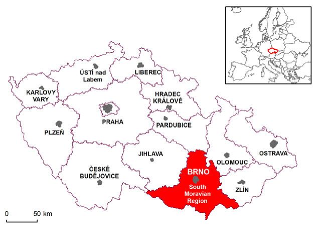
70                             Lucie Kubalíková, Karel Kirchner, Aleš Bajer

                                                       7 – Stránská skála
                                                            Stránská skála is a site of geological, palaeonto-
                                                       logical, archaeological and historical importance.
                                                       It is a denudation relict of Jurassic limestones with
                                                       rich palaeontological findings (e.g. crinoids). The
                                                       limestone was extracted and used as a decoration
                                                       stone (e.g. fountain in Špilberk castle in the cen-
                                                       tre of Brno) and later, before WWII, the site was
                                                       selected as suitable for the construction of under-
                                                       ground shelters and factories.
                                                            These underground spaces represent indus-
                                                       trial and military landforms within Brno district.
                                                       For several years, the landforms served as a shel-
                                                       ter for homeless people. Today they are closed,
                                                       but they still attract people. The site is also inter-
                                                       esting from the botanical point of view (Pulsatilla)
                                                       and it is abundantly visited during the spring.
                                                       Archaeologically it is an important Palaeolithic
                                                       locality that shows evidence of settlement al-
                                                       ready 600,000 year BP (Homo erectus). It is one
                                                       of the most important locality from this point of
                                                       view. Later, the evidence of human presence is
                                                       proved in the period 30,000 – 40,000 year BP.
                                                            The site is also important from the palaeogeo-
                                                       graphical point of view: the Svitava river flew
                                                       nearby (today, the position of the stream chan-
 Fig. 7. The Ossuary under the Saint James Church –    nel is different) and created numerous branches
 an example of underground funeral anthropogenic       here, so the landscape had a different pattern
          landform (Photo: K. Kirchner, 2015).         compared to today.
                                                            The limestone quarry is used as an excursion
geology.cz/extranet/mapy, accessed 29.06.2017),        locality and generally it is a favourite place for
which belongs to the oldest rocks within the study     visits and walks, the accessibility by public trans-
area. The purpose of this shelter was to protect       port is good. The marked tourist paths are present
prominent people of Brno and South Moravian            as well as tourist shelters, the site has thus a big
Region during the Cold War in the case of atom-        potential for geoeducation and geotourism too.
ic attack. Originally it served as a war shelter al-
ready during World War II. In the 1946–1948 peri-      8 – Bosonožský hájek
od it was used as a stock for the winery wholesale        Bosonožský hájek is located westward of Brno
store Löwy and Šmíd, but after nationalization it      in the eastern slopes of the Bobravská vrchovi-
was transformed to the shelter with a capacity of      na Highland (1.1 km southeast from city district
500 people during 3 days. Today, there is a citi-      Brno Žebětín). It is a unique example of intensive
zens’ initiative “American fund” whose aim is to       gullying of Pleistocene loess deposits; locally the
use the originally military landform for cultural      incision reached even the underlying granitoid
purposes. Together with the Tourist Information        bedrock. Three types of gully networks can be
Centre of Brno it organizes excursions, which are      recognised according to their extension and mor-
focused mainly on the historical aspects of the        phology. The approximate length of whole net-
site. Unfortunately (as in the case of Brno under-     work is about 18,354 m and the density is about
ground – Ossuary and cellars under Zelný trh),         39.25 km∙km-2 (Kirchner et al. 2011).
the geological and geomorphological aspects are           The formation and development of a gul-
omitted or only slightly mentioned (Tourist infor-     ly network is conditioned by natural factors
mation centre of Brno 2017).                           and human activities, e.g. intensive water
Secondary geodiversity and its potential for urban geotourism: a case study from Brno city 71
erosion during flash floods or track construction potential for geotourism and geoeducational ac-
(Kirchner et al. 2011). In the southern part of the tivities, but in some cases the potential is not rec-
study area, there are remnants of historical ag- ognised. The next step of the research is the de-
ricultural terraces (terraces were used probably tailed analysis and evaluation of the geotourism
as vineyards) dissected by erosion. In the eastern and geoeducational purposes of particular sites
part of this site, historical paths pass through the based on methods used within the concept of
study area (this fact is documented by historical geomorphosites (e.g., Coratza, Giusti 2005, Pralong
maps from the 2nd Military Survey of 1836–1852). 2005, Reynard et al. 2007, Pereira, Pereira 2010,
These paths were eroded and deep gullies were Kubalíková 2013, Bajer et al. 2015, Kubalíková,
formed and they are still well visible. This terri- Kirchner 2016) and eventually, analysis of the
tory is a subject of interdisciplinary research with demand of potential visitors. Then, the specific
respect to dating of the main phases of natural proposals for the geoeducational and geotouris-
and human-induced gully incision. tic use will be presented.
Analysis of the geotourism Conclusions
and geoeducational potential
Although some anthropogenic landforms rep-
Based on the terrain research, freely accessi- resent big intervention to the natural ambient,
ble maps (Národní geoportál INSPIRE, https:// some of them can increase the diversity of natu-
geoportal.gov.cz/web/guest/home, accessed ral environment and they can create good basis
29.06.2017) and other resources (cited above), a for diversification of the ecosystems. Also, some
SWOT analysis of the geotourism and geoeduca- of anthropogenic landforms are very important
tional potential of the sites was done (Table 1). from the historical and archaeological point of
SWOT analysis is a simple assessment tool, which view, so the overall value of these geosites and
presents Strengths, Weaknesses, Opportunities geomorphosites is composed of the scientific
and Threats. It helps with strategic planning and and cultural value. Moreover, some landforms
decision-making and it is widely used both for uncover the features, which would normally
planning in companies and planning the commu- remain hidden; in this sense they increase the
nity or regional development. geodiversity of the area. As they show various
Based on the SWOT analysis it can be said that geological outcrops or geomorphological pro-
anthropogenic landforms within Brno possess a cesses, they can serve as a terrain handbook for
Table 1. SWOT analysis of the geotourist and geoeducational potential of the anthropogenic landforms within
Brno city.
Strengths Weaknesses
–– big diversity (although there are no menhirs or cromlech –– some sites and areas are private, accessibility is
(celebration landforms in general), but the rest of the genetic restricted or possible only with a permission
groups is represented) –– the geo-feature is oppressed (esp. Brno under-
–– high number of sites ground) and consequently, the interpretation and
–– representativeness and easy recognizability of the landforms promotion of the geo-features of some sites is not
and processes (pedagogical and educational potential) good
–– accessibility (on foot, by public transport) –– inadequate use of some sites (waste, vandalism,
–– existence of tourist paths high exposure to the visitors)
Opportunities Threats
–– higher promotion of the geo-features can increase the attrac- –– not politically attractive theme
tiveness of the sites –– ongoing and continuing inadequate use of some
–– the added values of the sites can attract visitors to the sites
geo-features –– high exposition to the visitors, damage of the
–– geoeducation, sustainable geotourism and recreation as an sites
alternative for “classical” trips to the Brno surroundings –– no conception of the geoeducation and geotour-
(e.g. Moravian Karst which is overloaded by visitors) ism on the urban level (or regional level)
–– recognizing the importance of geo-features –– the fight between the geoscientists and biologists72 Lucie Kubalíková, Karel Kirchner, Aleš Bajer
Earth sciences and they can be used for geoedu- the geoeducational and geotouristic potential of
cational purposes. Anthropogenic landforms are these significant sites will not be fully and ration-
often visually attractive; so they have big poten- ally exploited.
tial for recreational and tourist activities. In many
cases, anthropogenic landforms also document Acknowledgement
prehistoric and historical development of relief
and landscapes and therefore they are a part of The article was supported by long-term con-
the geomorphological attempt to geodiversity ceptual development support of research organ-
(Thomas 2012). isation (Institute of Geonics, Czech Academy of
Thus, secondary geodiversity with its par- Sciences, v.v.i.) RVO: 68145535.
ticular features – anthropogenic landforms –
undoubtedly represents a significant part of the
Brno city’s geoheritage and it can be viewed as References
a considerable resource for geotourism and geo-
Bajer A., 2012. Geologické vycházky okolím Brna (Geological
educational activities. In some cases, its potential walks around Brno). Rezekvítek Brno.
is already recognised and rationally used, but Bajer A., Kirchner K., Kubalíková L., 2015. Geodiversity val-
other important sites are neglected, poorly pro- ues as a basis for geosite and geomorphosite assessment:
a case study from Žďárské Vrchy Highland. In: Lněnička
moted and the care about them is not sufficient. L. (ed.), Proceedings of 23rd Central European Conference:
However, there are some important projects 56–69.
on geodiversity, geotourism and geoeducation Chlupáč I., Jaeger H., Zikmundová J., 1972. The Silurian-De-
vonian boundary in the Barrandian, Bulletin of Canadian
within Brno and South Moravian Region:
Petroleum Geology 20(1): 104–174.
–– Geological walks (Bajer 2012), Cílek V., 2002. Geodiverzita – opomíjený aspekt ochrany
–– Geology of the Brno and its surroundings přírody a krajiny (Geodiversity – a neglected aspect of
(Müller, Novák 2000), nature and landscape conservation). Zprávy o geologických
výzkumech v roce 2001: 13–15.
–– Database of the geological localities (Czech Coratza P., Giusti C., 2005. Methodological proposal for the
Geological Survey 2017b), assessment of the scientific quality of geomorphosites.
–– Significant geological sites of Moravia and Il Quaternario, Italian Journal of Quaternary Sciences 18(1):
305–313.
Silesia (Vávra, Štelcl 2014), Czech Geological Survey, 2017a. Maps. Online: www.geolo-
–– Some non-profit organisations hold programs gy.cz/extranet/mapy (accessed 30 March 2017).
for children, guided excursions, talks and Czech Geological Survey, 2017b. Significant geological locali-
presentations. ties of the Czech Republic. Online: lokality.geology.cz (ac-
cessed 30 March 2017).
These projects are a good starting point for Demek J., Havlíček M., Kirchner K., Nehyba S., Lisá L.,
similar activities and more detailed analysis of 2005. K rozšíření poznatků o kvartérních sedimentech
the potential of secondary geodiversity in the na Červeném kopci v Brně (Distribution of Quaternary
sediments on the Červený kopec (Red Hill) in Brno). In:
study area. Geomorfologický sborník. České Budějovice: Jihočeská uni-
Conceptually, there is no document about verzita v Českých Budějovicích, 2005: 159–163.
geoeducation and geotourism for Brno and its Demek J., Mackovčin P. (eds), 2014. Zeměpisný lexikon ČR.
Hory a nížiny (Geographical lexicon. Mountains and low-
surroundings or for the South Moravian Region;
lands). Agentura ochrany přírody a krajiny ČR, Brno, 607
in the Conception of the environmental education for p.
the South Moravian Region (Jihomoravský kraj 2010), Dingwall P., 2005. Geological world heritage: a global framework.
unfortunately, there is nothing about geodiver- A Contribution to the Global Theme Study of World Heritage
Natural Sites. IUCN, WCPA, UNESCO.
sity. At the State level, general documents on Dixon G., 1996. Geoconservation: An International Review and
geodiversity, geoeducation and geotourism are Strategy for Tasmania. Occasional Paper 35, Parks & Wild-
missing too. life Service, Tasmania, 101 p.
Dowling R.K., 2011. Geotourism’s Global Growth. Geoherit-
Above-mentioned facts should be respected age 3(1): 1–13.
and included into the landscape management, Dowling R.K., Newsome D. (eds), 2010. Geotourism. The tour-
regional planning and development strategies. ism of geology and landscape. Goodfellow Publishers, Ox-
The cooperation of the specialists of the different ford, 246 p.
Eberhard R. (ed.), 1997. Pattern and Process: Towards a Region-
branches is also desirable (scientists, teachers in al Approach to National Estate Assessment of Geodiversity.
the primary, secondary and high schools, local Technical Series No. 2, Australian Heritage Commission
authorities, owners of the landforms), otherwiseSecondary geodiversity and its potential for urban geotourism: a case study from Brno city 73
and Environment Forest Taskforce, Environment Aus- Peterková L., 2011. Reliéf a geomorfologický vývoj řeky Svratky v
tralia, Canberra. brněnském prostoru v severozápadní části Bobravské vysočiny
Gray M., 2013. Geodiversity: Valuing and Conserving Abiotic (Relief and geomorphological development of the Svrat-
Nature. Wiley Blackwell, Chichester, 495 p. ka river in Brno area in NW part of Bobravská vrchovina
Jihomoravský kraj, 2010. Koncepce EVVO Jihomoravského kra- highland). Ph.D. thesis. Masarykova univerzita, Příro-
je na období 2011–2020 (Conception of the environmental dovědecká fakulta, Brno, 147 p.
education for the South Moravian Region). JMK, Brno. On- Pralong J.P., 2005. A method for assessing tourist potential
line: https://www.kr-jihomoravsky.cz/Default.aspx- and use of geomorphological sites. Géomorphologie: relief,
?ID=154180&TypeID=2 (accessed 29 June 2017). processus, environnement 3: 189–196.
Kirchner K., Münster P., Máčka Z., 2011. Stržový systém Reynard E., Fontana G., Kozlik L., Scapoza C., 2007. A meth-
v Bosonožském hájku – jedinečný geomorfologický od for assessing the scientific and additional values of
fenomén západně od Brna (Gully system in Bosonožský geomorphosites. Geographica Helvetica 62(3): 148–158.
hájek – a unique geomorphological phenomenon west Sharples C., 2002. Concepts and principles of geoconservation.
of Brno). Geologické výzkumy na Moravě a Slezsku 18(2): Tasmanian Parks & Wildlife Service website, Septem-
33–36. ber 2002. Online: xbiblio.ecologia.edu.mx/biblioteca/
Kirchner K., Smolová I., 2010. Základy antropogenní geomor- Cursos/Manejo/Geoconservation.pdf (accessed 9 March
fologie (Elements of anthropogenic geomorphology). Uni- 2011).
verzita Palackého v Olomouci, 287 p. Šlezingr M., 1998. Vliv lodní dopravy na Brněnské přehradě
Kubalíková L., 2013. Geomorphosite assessment for geotour- na vznik abraze břehů (Influence of shipping on the Brno
ism purposes. Czech Journal of Tourism 2(2): 80–104. Dam to the creation of shoreline abrasion). In: Přehradné
Kubalíková L., Bajer A., Kirchner K., 2016. Secondary geodi- dni 1998 – sborník referátov, Košice: 154.
versity and its potential for geoeducation and geotour- Šlezingr M., 1999. Prezentace výsledků monitoringu postu-
ism: a case study from Brno city. In: Fialová J., Pernicová pu abraze na březích údolní nádrže Brno v letech 1989 –
D. (eds), Public recreation and landscape protection – with 1999 (Presentation of the results of the monitoring of the
nature hand in hand… Conference proceeding. Mendel process of abrasion on the banks of the Brno reservoir in
University Brno: 224–231. the years 1989-1999). Vodní hospodářství 9: 192–193.
Kubalíková L., Kirchner K., 2016. Geosite and Geomor- Smolíková L., 1990. Regionální paleopedologie (Regional
phosite Assesment as a Tool for Geoconservation and Palaeopedology). In: Němeček J., Smolíková L., Kutílek M.,
Geotourism Purposes: a Case study from Vizovická vr- 1990. Pedologie a paleopedologie, Academia: 405–479.
chovina Highland (Eastern Part of the Czech Republic). Svoboda A., 2008. Brněnské podzemí I (Brno underground I).
Geoheritage 8(8): 5–14. R-ateliér spol. s r.o., Brno, 168 p.
Kukla G., 1975. Loess stratigraphy of central Europe. In: Szabó J., Dávid L., Loczy D. (eds), 2010. Anthropogenic Ge-
Butzer K.W., Isaac G.L. (eds), omorphology. A Guide to Man-Made Landforms. Springer,
After the Australopithecines, Mouton Publishers: 99–188. Dordrecht, 250 p.
Müller P., Novák Z., 2000. Geologie Brna a okolí (Geology of Thomas M.F., 2012. A geomorphological approach to geodi-
Brno and its surroundings). Český geologický ústav Pra- versity – its applications to geoconservation and geotour-
ha, 90 p. ism. Quaestions Geographicae 31(1): 81–89.
Musil R., 1982. Současný stav poznatků o kvartéru Brněnské Tourist information centre of Brno, 2017. Shelter 10-Z. Online:
kotliny (The current state of knowledge about the Qua- ticbrno.cz/cs/podzemi/kryt-10-z (accessed 30 March
ternary of the Brno basin). Studia Geographica 80: 261–268. 2017).
Národní geoportál INSPIRE, 2017. Maps. Online: geoportal. UNESCO, 1972. Convention concerning the protection of the
gov.cz/web/guest/home (accessed 26 June 2017). world cultural and natural heritage. Online: whc.unesco.
Novák Z. et al., 1991. Geologická mapa 1:50 000, list 24-32 Brno org/archive/convention-en.pdf (accessed 17 November
(Geological map 1:50 000, sheet 24–32 Brno). Český geo- 2010).
logický ústav, Praha. Vávra V., Štelcl J., 2014. Významné geologické lokality Moravy
Pereira P., Pereira D., 2010. Methodological guidelines for a Slezska (Significant geological localities of Moravia and
geomorphosite assessment. Géomorphologie: relief, proces- Silesia). Masarykova Univerzita Brno, 290 p.
sus, environnement 3: 215–222. Zeman A., 1992. New data on the Quaternary at Červený ko-
pec hill in Brno. Scripta Geology 22: 123–131.You can also read