PUBLIC SPACE IN BANGALORE: PRESENT AND FUTURE
←
→
Page content transcription
If your browser does not render page correctly, please read the page content below
SECTION II
                PUBLIC SPACE IN BANGALORE: PRESENT AND FUTURE
                                  PROJECTIONS

This section provides a brief introduction of the growth of Bangalore from a fort city to a large metropolis. This section studies public space in Bangalore
since the colonial period. It describes the origin of many of Bangalore’s public spaces and traces their history to the present times. It also describes the
issues and problems facing public space today and draws conclusions regarding ways to address them. Chapter 5 outlines the history of the city from 1537
AD to the present, with emphasis on the development of the city. The intention of this chapter is to understand how Bangalore evolved and the issues that
were created by urbanization as it applies to public space. Chapter 6 discusses the different public space types that developed in the Indian city and the
colonial city until independence in 1947. Emphasis is laid on the two urban form types that characterised the two cities of Bangalore and the consequent
public spaces they generated. Chapter 7 deals with public space after independence. The various public space types are identified and discussed in detail.
Emphasis has been give to the history and present use of these spaces. This chapter establishes the primacy of the street as an important public space in
Bangalore. Chapter 8 explores the various struggles and problems taking place in Bangalore’s public spaces. It especially describes the language movement
in the city and the lack of imageability of Bangalore. This chapter establishes the connection between these issues and the contest for public space and the
absence of a clear city centre. Chapter 9 describes the evolution of M.G. Road as Bangalore’s de-facto city centre. It studies M.G. Road in detail and how it
is used today. It also outlines the future issues facing M.G. Road. Chapter 10 makes the argument that Bangalore today is faced by three main problems –
the congestion of M.G. Road (Bangalore’s evolving city centre), the lack of an imageable city centre and the contest for public space and its privatisation. The
chapter suggests a solution to the above issues by way of a central public space, which will address the various issues and become a binder physically and
socially while portraying a coherent city centre image.

                                                                                                                                                             33
CHAPTER 5: BANGALORE: MUD FORT TO SPRAWLING METROPOLIS

Today Bangalore is India’s fifth largest city and one of the fastest growing. It has a population of around 5 million and is a true cosmopolitan city. However it
had modest beginnings and the origin of “Bengalooru” is lost in history. Though several artefacts have been found dating back to 900 AD and even earlier
Bangalore in its present context was founded when a mud fort was built at “Bengalooru”. Kempe Gowda I, a feudatory of the Vijayanagara Empire, built it in
1537 AD and made it his capital.

5.1. KEMPEGOWDA TO TIPU SULTAN (1537 AD TO 1791 AD)

The fort built by Kempe Gowda I was of modest dimensions with mud as the main building material1. Within the fort the town was divided into petes or
localities such as Chickpete, Dodpete, Balepete, Cottonpete and other areas earmarked for different trades and artisans. The town had two main streets,
Chickpete Street ran east to west and Dodpete Street ran north to south, their intersection forming Dodpete Square, the heart of Bangalore. Kempe Gowda I
encouraged the construction of temples and lakes and planned residential layouts, or agraharams, around each temple2. The construction of the mud fort
and several temples and lakes transformed Bangalore from a sleepy village to a centre of culture based on the Hindu religion3. Kempe Gowda II was an able
successor to his father under whom Bangalore developed in the tradition of the Vijayanagara cities, a mosaic of bazaars, temple complexes and agraharams.
He also the built the four famous towers that marked Bangalore’s boundary. Kempe Gowda II suffered a crushing defeat at the hands of the Bijapur armies
led by Shaji in 1638 AD who made Bangalore a centre of Maratha culture4. Bangalore, though, soon fell to the Mughal army under Khasim Khan in 1687 AD,
who leased the city and the surrounding areas to Chikkadeva Raya Wodeyar in 1690 AD. Chikkadeva Raya Wodeyar (1673 AD- 1704 AD) built an oval
shaped fort south of the old mud fort. After the death of the Wodeyar in 1704 AD, Hyder Ali usurped the throne and ruled Mysore with his son Tipu Sultan
until the British defeated him in 1790 AD. Hyder Ali got the oval fort in the south rebuilt in stone5. The palace started by Hyder Ali was built within this fort and
was completed by Tipu. The town was about 5 kilometres in circumference, with the fort at the south end, with well planned streets and prosperous shops
indicating a flourishing economy6. A big market stretched from the north gate of the town to the oval fort, a predecessor of today’s Avenue Road. Hyder and
Tipu also contributed towards the beautification of the city by building Lalbag Garden in 1760 AD. Under them Bangalore developed into a commercial and
military centre of strategic importance.

5.2. COLONIAL PERIOD (1791 AD to 1947 AD)

The British found Bangalore to be a pleasant and appropriate place to station their garrison and thus a cantonment was built. It was separated by an 11.5-
kilometer wide strip of open land, from the ‘native town’ or pete. Maya Jayapal explaining the origin of the word cantonment says,
    “The origin of the word ‘Cantonment’ is from the French canton, meaning corner or district. It has become, through usage, an Anglo-Indian word and
    is applied to military stations in India, built usually on a plan, which was originally that of a standing camp or cantonment. Each cantonment is
    essentially a well defined and clearly demarcated unit of territory set apart for the quartering and administering of troops”7.

                                                                                                                                                                  34
Cantonments were built by the British primarily for security and health. With the defeat of Tipu Sultan the British became the foremost power in south India.
Bangalore ceased to be a strategic citadel in the medieval sense, instead becoming a British cantonment. Bangalore fort slowly passed into oblivion, the fort
walls coming down in stages to make way for the expanding city. The Parade Ground, surrounded by a ride or mall called Rotten Row, was more or less the
heart of Bangalore Cantonment8. Around this grew the Civil & Military Station (CMS). A civilian population of lower economic strata, attracted by the
opportunities for employment and trade and offering subsidiary services to the military personnel, settled in a high density and congested, unhealthy locality.
This is due to lack of concern shown by the British towards them. This area evolved into a general bazaar called Blackpally, which is today’s Shivajinagar
area. According to Prof. M.N. Srinivas some parts looked like a small Tamil town like Vellore, with houses having Tamil style verandas facing the street.
These verandas were important spaces to socialise and also to segregate the private areas of the house from the outside. There were also slums on the
outskirts of the colonial city like Pottery Town9. According to P.D. Mahadev the colonial city unintentionally helped decongest the old native city and also
provided much needed ‘lung space’10. Several developments, led to the rapid growth of the city. The most important of these being the telegraph connections
introduced to and from Bangalore to all the important cities of India in 1853 AD and the rail connection to Madras in 1864 AD. Hence with city walls gone and
unprecedented growth of the city it began to sprawl into the countryside unchecked. By 1881 AD, Bangalore had two nuclei: one a high-density area around
the fort and its market (K.R. Market area) in pete and the second Blackpally (Russel Market area) within the colonial city. Both of these comprised the inner
city of Bangalore with Cubbon Park acting as a large green buffer. Several suburbs were built at the turn of the century. By 1931 AD the CMS’s population
was 134,113 and that of Bangalore was 308,000.
5.3. POST INDEPENDENCE (1947 AD to Present)
In 1947 India gained independence and the Indian and colonial cities were merged in 1949. Bangalore has since remained the capital of Karnataka state.
Bangalore continued to grow and several public sector industries were set up from 1940 -1970 transforming it into a science and technology centre. By 1961,
Bangalore had become the 6th largest city in India with a population of 1,207,000. Between 1971-1981, Bangalore’s growth rate was 76%, the fastest in Asia.
By 1988 the Electronic City had been developed and Bangalore emerged as India’s software capital. Consequently the 1990’s saw a construction boom
fuelled by Bangalore’s growing reputation as “India’s silicon valley”, which saw many young professionals migrate to the city.
5.4. CONCLUSION
Bangalore continues to grow at a rapid pace and today the city has expanded into a large metropolis, an international technology hub specializing in
aerospace, information technology and biotechnology. Today Bangalore’s population stands at roughly 5 million. Though Bangalore grew in all directions,
pressure has been particularly intense on the inner city, which continues to grow with two nuclei, though over the years this distinction has blurred. One is the
very high-density area around the city railway station and K.R. Market and the other being the M.G. Road and Russel Market areas. The stress in these
areas is still intense, especially on public spaces such as streets, as the outward growth of Bangalore continues. As early as the 1970’s Rao & Tewari
suggested that Bangalore should integrate various areas and elements of the city with the street and land-use structure, and develop a cellular and hierarchic
city structure11. Even today Bangalore comes across as an unstructured city without any hierarchy. Attempts have been made to introduce ring roads and
radial roads to give structure. In addition, attempts to decongest core areas have been partly successful with new satellite commercial centres developing in
the better-planned suburbs such as Jayanagar.
35REFERENCE
1. Ribeiro, E.F.N. – From Mud Fort to Metropolitan Region, Architecture+Design, March-April 1999, pg. 28, 29.
2. Jayapal, Maya – Bangalore: The Story of a City, East West Books (Madras) Pvt. Ltd., pg. 11.
3. Issar, T.P. – The City Beautiful, Bangalore Urban Arts Commission, 1998, Bombay, pg. 238.
4. Jayapal, Maya, pg. 16, 17.
5. Jayapal, Maya, pg. 25, 26.
6. Jayapal, Maya, pg. 35, 36.
7. Jayapal, Maya – Bangalore: The Story of a City, East West Books (Madras) Pvt. Ltd., pg. 49, 50.
8. Jayapal, Maya, pg. 54.
9. Prof. M.N. Srinivas, Bangalore: Scenes from an Indian City, Gangarams Publications Pvt. Ltd., pg. 17.
10. Mahadev, P.D. – Bangalore: A Garden City of Metropolitan Dimensions (Million Cities of India), pg. 243.
11. Prakasarao, V.L.S. and Tewari, V.K., pg. 172, 174.
36CHAPTER 6: PUBLIC SPACE: COLONIAL PERIOD
This chapter examines the evolution of public space during the colonial period. The evolution of the colonial city into the Central Business District (CBD) of
Bangalore and the role of M.G. Road as the primary public space are discussed in detail. This chapter draws conclusions regarding the urban form and the
types of public spaces that developed during the colonial era.
Bangalore in the 19th century was a twin city comprising the pete, or Indian city, and the cantonment, or the colonial city. Both followed their own traditions of
urban form and thus evolved different sets of public spaces. However, each presented a highly imageable urban structure: the Indian city continued the
medieval tradition of high-density, mixed-use neighbourhoods with temple squares and markets forming nodes and open spaces in the other wise close-knit
urban fabric; the British on the other hand adopted the cantonment type urban form, which was the antithesis of the Indian city. In contrast with the narrow
meandering streets of the pete, the cantonment developed with wide tree-lined avenues and spacious bungalows. The mall, parade ground and park were
some of the public spaces that were developed in the colonial city.
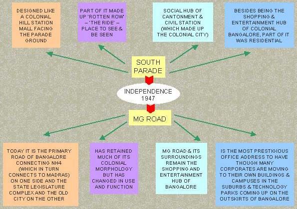
By 1812 AD the colonial city developed as a low density “Garden City”, with a parade ground, clubs, churches, bungalows, shops, markets, cinemas, and
parks and other open spaces interspersed by water bodies. The colonial city had a strong European character, with public life and thus public space centred
on and around South Parade. South Parade, today’s M.G. Road, and the area around it became a fashionable mall with bars and restaurants and all sorts of
shops catering to European tastes with Blackpally catering as a bazaar for everyday needs1. A bridle path also existed around Parade Ground, which was a
popular place to promenade. Cubbon Park, which was developed in 1864 AD on about 120 hectares of land, was a popular public space for people from both
the pete and the cantonment 2. Besides Cubbon Park several smaller parks were developed in the colonial city, which were popular community spaces. Also
an amusement park called ‘Hollywood City’ was set up on Police Parade grounds during the Second World War and a skating rink owned by a Jewish family
existed at the corner of Cubbon road and Curzon road3. The streets in the cantonment were important public spaces and were straight and wide and were
designed for vehicular traffic, but of a different kind from today’s motorised traffic. The streets had slow moving traffic with plenty of space for pedestrians and
bicyclists. Cars were introduced in Bangalore in the beginning of the 20th century. The car, scooter and motorcycle slowly replaced the carriage and bicycle
as the preferred mode of transport from the 1960’s onwards and the quality of the streets rapidly deteriorated.
The Indian city had a clear edge, which differentiated the high-density city from the countryside and hence was clearly legible. The streets were carved out of
the mass of buildings and hence were “elemental streets”, as identified by William C. Ellis. In other words the street had felt volume and became an outdoor
room with the facades of the buildings belonging to the street rather than the buildings. Therefore the streets had a very strong character and were highly
imageable. They were channels of communication and interaction, which held the city together. Where two streets intersected they opened up to form temple
squares or market squares and these acted as nodes. They were important punctuation points in the rhythm of the street and were highly imageable spaces.
Hence going by Kevin Lynch’s theory of imageability the Indian city had a strong edge differentiating it from the country side, had paths in the form of streets
as external rooms, which opened up into squares as nodes with a landmark overlooking it like a temple or a market. The city itself was divided into districts
based on trade and caste each having a unique character. Therefore one can conclude that the Indian city was a highly imageable entity.
The colonial city was developed on the “tower in space” model of urban development. But in spite of this it had a strong image. Firstly South Parade, which
was the centre of the colonial city, had a very strong character of low-rise commercial buildings facing a parade ground with a bridle path around it. This
37formed a highly imageable city centre. Around this grew residential neighbourhoods and the cantonment proper, which had a strong colonial character and
were divided based on class. Hence they can be called districts based on Lynch’s theory. The whole city was interspersed by parks and lakes, which formed
nodes throughout the city. Cubbon Park, which separated the Indian city from the colonial city, formed a major edge. Finally the juxtaposition of the high-
density compact Indian city and the low-density sprawl of the colonial city made them highly imageable due to the contrast between them.
The only feature that tied the two cities was the ‘Garden City’ image, which was pursued in the colonial city and the suburbs of the Indian city. Bangalore’s
‘Garden City’ image originated with the development of Lalbag Garden. In 1908 Krishnaraja Wodeyar IV appointed Mr. Krumbiegel as the Government
Horticulturist. During the period 1908 to 1932, he not only developed Lalbag Garden but also beautified the entire city. He planted several avenue-trees along
streets and promoted the idea of “serial blooming”. Dr. Mari Gowda who succeeded him continued his good work4. Bangalore’s parks and lakes along with
the spacious bungalows all combined to enhance its image as a ‘Garden City’. Bangalore continues to be called a garden city although few parks and lakes
have been added to the city in recent years and high-rise buildings have replaced many bungalows. A concerted effort is underway to improve the existing
open spaces and enhance Bangalore’s ‘Garden City’ image.
CONCLUSION
In conclusion the Indian city developed like other traditional south Indian cities with agraharams, narrow meandering streets and temple and market squares.
The streets and squares formed ‘outdoor rooms’ where people performed their daily chores. The city was mainly a pedestrian precinct. The public spaces
that evolved were bazaar streets, temple squares, lakes and maidans (open grounds). These spaces responded to the type of urban fabric and were thus
intimate in scale responding to the needs of a pedestrian. Public space was closely connected with religion and thus temple and mosque squares were
important. Also the Karaga festival, which was an annual procession, used the pete’s streets as a stage. Maidans were important recreation spaces for
children to play and for the elderly to walk and socialise. These public space types will be discussed in detail in the following chapter. Lalbag Garden, which
was initially developed as a resort for the rulers, became a very popular public park. It wasn’t until the reign of the Wodeyars (19th century) that public
gardens were developed in the suburbs adjoining the traditional city. The newer suburbs that were developed like Basavangudi were influenced by western
planning ideas and had wider roads with large plots for bungalows and several parks and gardens. These suburbs were sprawled out in comparison to the
pete, and thus people who could afford to commute by carriage or jutka lived there. The streets were in a gridiron pattern and were designed to cater to
heavier traffic.
During the colonial period the pattern of development moved away from the traditional form and introduced a cantonment form of development. The city that
developed thus had wide roads with buildings set back from the sidewalk within large compounds. The mall, parade ground and the park were the preferred
types of public spaces. The British tried to create ‘a bit of England in India’ in Bangalore. People were expected to commute by carriages or bicycles hence
the streets that were developed were wide and the cantonment in general was sprawled over a large area. The street being the primary public space
developed as a boulevard with wide pedestrian space to stroll and window shop. Ample tree canopy provided shade from the summer sun. South Parade or
M.G. Road developed as the centre of the colonial city and continues to evolve today as the centre of Bangalore. Prof. M.N. Srinivas feels that the British
could have planned a “fine city” but chose to ignore the civilian areas growing around the cantonment, which led to haphazard development with narrow
windy roads5.
38As a result Bangalore has evolved into a bi-nuclear city – with pete and cantonment areas as its two cores. After independence the city was merged into one
entity and grew rapidly tending towards a compact circular shape. Though the city is more unified than before the bi-nuclear nature of the city remains to
date. M.G. Road area lying roughly at the centre of the two cores has evolved as the CBD and the de-facto centre of Bangalore. Bangalore’s evolution was
rapid, from a colonial outpost to administrative/commercial city, and from a science/education city to InfoTech and services centre. With Bangalore’s rapid
growth came related problems, which led to the city bursting at its seams and the infrastructure buckling under pressure. In a continuing bid to slow down
Bangalore’s growth and divert some of the development pressure to other cities, satellite townships were developed and it was proposed that counter
magnets to the city be encouraged. Besides pressure on infrastructure and congestion in the city there was a gradual loss of public space due to
developmental pressures. Lakes were covered for development, parks were encroached upon and insufficient open spaces were allocated in the new illegal
developments in fringe areas. Growth of the city has changed the demography and hence the new users have different needs, which will be discussed in
detail in the following chapter.
REFERENCES
1. Jayapal, Maya – Bangalore: The Story of a City, East West Books (Madras) Pvt. Ltd., pg. 54, 55.
2. Ribeiro, E.F.N. – From Mud Fort to Metropolitan Region, Architecture+Design, March-April 1999, pg.28, 29.
3. Jayapal, Maya, pg. 100.
4. Issar, T.P. – The City Beautiful, Bangalore Urban Arts Commission, 1998, Bombay, pg.60.
5. Prof. M.N. Srinivas, Bangalore: Scenes from an Indian City, Gangarams Publications Pvt. Ltd., pg. 17.
39CHAPTER 7: PUBLIC SPACE: POST INDEPENDENCE
This chapter examines the evolution of public space after independence and the current status of these public spaces. It examines the various public space
types that are being used today and draws conclusions for future trends in use and development of public spaces.
7.1. STRUCTURE OF THE CITY
After independence the two cities were merged and both types of public spaces, traditional and colonial, became familiar to the citizens. Traditional families
continued to prefer the pete area, which supported their life style, while the more westernised citizens found the cantonment area to be more to their liking. In
spite of the differences between the public spaces of the two cities one can draw parallels between them – for example the parade ground was similar to the
maidan, spatially at least. Like wise the bazaar street was similar to the mall in function, if not spatially. The two old nuclei though, did not merge because of
Cubbon Park and the Administrative Complex, which separated them. Hence even today Bangalore can be called a bi-nuclear city, although this distinction is
becoming blurred. Rao & Tewari felt that Bangalore’s bi-nuclear character was an advantage and should be maintained without letting them fuse, with
Cubbon Park acting as a green buffer1.
After independence most foreigners owning property and living in the colonial city left Bangalore either with or after the British troops left India. Many Anglo-
Indians also migrated to England or Australia because they felt insecure after the departure of the British. The density in the Cantonment area though,
continued to rise after independence, in spite of the presence of large public open spaces, the racecourse, golf club, and spacious grounds attached to clubs,
colleges, schools and other institutions. Even until the 1960’s Bangalore retained its “Garden City” image (see appendix) as a result of which it became
popular with retired people and others who wanted a quiet and green city to live in. Many people who wanted to escape from the hustle and bustle of other
metropolitan cities decided to settle down here. In the 1970’s land allocated for recreation was 8% of the city land. It was the highest among metropolitan
cities of India. According to Fazlul Hasan, Bangalore’s reputation as a ‘Garden City’ began with the Silver Jubilee Celebrations of the rule of His Highness
late Krishna Raja Wodeyar IV in 19272. The years that followed saw several works aimed at beautifying Bangalore. Parks, public buildings and hospitals
were built. It seems that this romantic image of Bangalore faded quickly and as early as the 1970’s Hasan laments that the rapid industrialization and
increase in population had damaged the beauty of the city, with slums proliferating in many areas2. Bangalore registered record growth during this decade
and as a result land prices escalated. Developers bought land and high-rise apartment and commercial buildings started replacing the bungalows. In 1889,
open space was four times the built up area. By 1980 the built up area was four times the open space area.
Many of the public spaces that exist today are a legacy of the colonial period. The streets and bazaars of the Indian city continue to function in a similar way
as before independence. South Parade has transformed into M.G. Road but continues to be a fashionable shopping and business street. Cubbon Park and
Lalbag Garden are as popular as ever. With the changes in urban structure and demography of the city have come some changes in recreational activities,
which have implications for the types of public spaces and their uses in Bangalore.
407.2. RECREATIONAL USE OF PUBLIC SPACE IN BANGALORE
Streets have always been important public spaces in Bangalore. M.G. Road and Avenue Road are some of the popular streets for shopping and recreation.
Bangalore is also known for its flowering trees, continuing a tradition started by Krumbeigal and Dr. Mari Gowda. Many of the city’s flowering street trees
were planted during their tenure. Some of the popular flowering trees of Bangalore are the champak (Michelia champaka), jacaranda (Jacaranda
mimosifolia), Africa tulip tree (Spathodea campanulata), the cannon ball tree (Couroupita guianensis), starry frangipani (Plumeria rubra), Gulmohar (Delonix
regia), and the rain tree (Entrolobium saman). According to Venkatarayappa, in the 1950’s walking on the tree-lined streets of Bangalore was a common
habit for the retired officers and others, both in the evening and the morning3. Even today one sees many senior citizens taking morning walks and younger
people jogging on Bangalore’s avenues and parks.
Bangalore has many playgrounds and sports fields, some more organized and structured than the others. For example the facility in Madhavan Park has a
skating rink, basketball courts, a running track and soccer and cricket grounds, whereas some of the others are just open fields or maidans where several
groups are playing different games, mostly cricket and soccer. These look chaotic but each group is following their respective matches and games as if they
were the only ones on the field. Several of the schools and colleges, especially those run by the government, allow the general public to play on their fields
on holidays and after they close for the day.
A survey conducted by Rao & Tewari in the 1970’s revealed some interesting facts regarding public space use – only 4% of the people surveyed went to
parks and walked as their primary leisure activity4. Thirty nine percent preferred going to movies and 26% to places of worship. As a second and third
preference, 8% and 17% respectively of the people surveyed listed going to parks as a leisure activity. They concluded that there was a case for a
“recreational complex” being developed in each neighbourhood based on the survey4.
While recreational uses have changed over the years, for the most part the traditional public space types of parks, gardens, streets, markets, and maidans
continue to serve the needs of Bangalore’s residents. However, the changing demography and people’s life style has resulted in new needs, which are not
being fully met by the traditional public spaces, especially in the Central Business District (CBD). At present semi-public spaces such as shopping malls and
open-air cafes are catering to these new needs. Also the quality of many public spaces has deteriorated due to over crowding or lack of management. As a
result they no longer cater to the needs of people. This calls for a careful study of the existing public space types to identify the needs that are being met and
the needs that should to be catered to and the implications for future use of public spaces.
7.3. PUBLIC SPACE TYPES IN BANGALORE
Traditionally parks and lakes have catered to the city’s need for being close to nature, and streets and markets have catered to the need for urban life and
interaction with people. Temples and mosques have served religious people and senior citizens, whereas maidans have been used by children to play.
These traditional uses of public spaces continue even today. However these traditional spaces are not fully meeting today’s needs, especially those of the
lower income groups, the nationalists and young professionals and teenagers. This will be discussed in detail in the following chapter. This section will study
the traditional public spaces and arrive at conclusions pertaining to their use and future trends. The urban public spaces existing in Bangalore can be broadly
41categorized into those that cater to people’s needs to be close to nature, such as parks and lakes, and those that cater to people’s urban life needs, such as
streets and markets. The following are some of the traditional types of public spaces existing in Bangalore today:
PARKS AND GARDENS
Today Bangalore has many parks and gardens, of these two of the most important parks in Bangalore are Lalbag Garden and Cubbon Park. Sir Richard
Sankey developed Cubbon Park in 1864. Cubbon Park served as a setting for Attara Kacheri (public offices which has been converted into the Karnataka
State High Court) and later Vidhan Soudha (Legislative Assembly). Cubbon Park also had a bandstand where the military band played for the public. This
tradition started with the celebration marking Queen Victoria’s 60 years of rule and went on till the 1960’s when an orchestra used to perform once a week.
According to Maya Jayapal the bandstand in the 1940’s and 1950’s was a place to promenade – to see and be seen5. Today Cubbon Park occupies about
150 acres of land in the centre of the city and the Attara Kacheri (High Court), the Seshadri Iyer Memorial Hall (Central Library), the State Archaeological
Museum and the Karnataka Government Insurance Department are housed there. It also has a children’s park with an amusement ground in a park setting.
Next to this is the complex of buildings housing the city aquarium, Government Art Museum and the Visveswaraya Science Museum. Throughout the
Cubbon Park are groves of shady trees and bamboo, turf, grass, flowering plants, creeks and ponds, promenades, seats and shady nooks for pleasure and
rest, meadows, woods and lawns. It is a naturalistic garden and is heavily used on holidays. Cubbon Park today caters to peoples’ active and passive
recreation needs. The lawns and meadows provide space for families to picnic, the children’s amusement ground has many rides and play equipment, the
woods provide space for solitude and contemplation and the many paths are popular among joggers and senior citizens. Thus Cubbon Park caters to
people’s relaxation and engagement needs (as identified by Carr and Lang), cognitive and aesthetic needs (by observing and enjoying nature), and has
become a sacred space full of meaning for the citizens who have formed a connection with it over several generations.
Lalbag Garden covers an area of about 240 acres. It was built during the reign of Hyder Ali and was originally only 40 acres. The original design was
influenced by the Mughal garden at Sira. It once housed a small zoo, which was very popular. A bandstand was built in the mid-1800 where the military band
used to play. After independence an orchestra gave performances there till 1976. The bandstand was also the venue for flower shows till the Glass House
was built. The Glass House, which has a plan in the shape of a cross, was modelled on the Crystal Palace in England. Today horticultural shows are held in
the Glass House throughout the year, which attracts many visitors. The Lalbag Lake, which is towards the southern end of the garden, is a popular attraction.
It covers 30 hectares and is bordered by Gulmohar trees. The lake is a great habitat for various birds, some migrating all the way from central Asia. Lalbag
Garden now also has an aquarium. The eastern end of Lalbag Garden has a small hillock on top of which stands one of the Kempe Gowda towers. One can
get a panoramic view of the city from here. Lalbag Garden today has become a very important botanical garden and a national landmark, especially the
Glass House, the hill with Kempe Gowda’s tower and the Mughal gardens. The rest of Lalbag Garden is a naturalistic park, which is used in much the same
way as Cubbon Park. Like Cubbon Park it caters to people’s relaxation and engagement needs (as identified by Carr and Lang), cognitive and aesthetic
needs (by observing and enjoying nature, the horticultural exhibitions and historic sculptures), and has become a national landmark, therefore steeped in
symbolic meaning and importance.
Though they are city parks, Cubbon Park is patronized mostly by people from the pete area and the CBD and Lalbag Garden by residents of the southern
suburbs like Basavangudi and Jayanagar. People in the northern suburbs go to Sankey Tank. Because people scorn public displays of affection, many
teenagers and newlyweds like spending time in relative seclusion in these parks. A walk through some of the more isolated spots of these parks reveal
couples, who look like they would go into a Bollywood style song sequence any minute. It is interesting to note Venkatarayappa’s observation that students at
the time of examination would sit under a tree in Lalbag to study6. Lalbag over the years has also evolved into a place for horticultural research and has a
42large library. Venkatarayappa also mentioned that no visitors left the city without visiting these gardens. He goes so far as to say that it was these gardens
that gave Bangalore the name of ‘Garden City’. Correa and Buch claim that it is the Defence lands, which gives Bangalore its garden city image7. The
defence services (military) own large areas of land in the city, which are underdeveloped. Cariappa Memorial Park is a relatively new garden developed by
the army on part of Parade Ground (a military land) in 1996 and named after Field Marshal Cariappa. It is a naturalistic garden with two waterfalls and a few
children’s play equipment. The rest of Parade Ground is under-utilised and there is potential to develop this into a central public space.
Open spaces are the lungs of a city. Correa and Buch lament that while Indian cities have tripled and quadrupled in population, the development of new open
spaces and maidans has been negligible except in Delhi and Bhopal7. Even Bangalore which claims to be a “Garden City’ has not added any significant open
space. Even the older spaces like Cubbon Park are being encroached into. The 1995 CDP however has proposed some “regional parks” to be developed.
Venkatarayappa in the 1950’s believed that “If Lalbag were not in existence in Bangalore, life in Bangalore would not have been so pleasurable and so fine
as it is today”6 – this holds true even today. In conclusion Bangalore’s parks and gardens cater to people’s relaxation, engagement, cognitive, aesthetic
needs and are symbolic of the green city image. These parks will continue to be used as they are and efforts will continue to preserve and enhance their
quality. In addition some of the “regional parks” will be developed on the lines of Cubbon Park and Lalbag Garden and will contribute towards the much
needed recreational space in other areas of the city presently not catered to by the large parks and lakes of Bangalore.
LAKES
The lakes of Bangalore were the main source of water during Kempe Gowda’s time. These were slowly forgotten as modern methods of water supply were
used. They have a pleasant impact on the climate of the city and provide a habitat for flora and fauna. Rapid urbanization has led to deterioration in the
quality of the lakes due to increase in impervious surface area. Maya Jayapal summarizes the plight of these lakes thus,
“The number of lakes has decreased from 262 in the 1960’s to 82. Many of these lakes have been converted into residential layouts, bus stands and
stadium. Some have been reduced to slums. Various reasons can be cited – failure to protect the beds, neglect of the embankments, decline in
rainfall, encroachment of lake beds for agriculture and construction, garbage dumping and the wild growth of the water hyacinth. All these cause
ecological and environmental problems, like the drying up of rivers and streams, and the stopping of movement of seasonal birds”9.
Many of the lakes were and still are associated with religious festivals like Karaga and Ganesh Chaturti. Besides this several lakes have boating facilities and
are very popular on holidays. Many lakes have also developed gardens along their banks, which is used by people for relaxation, and active and passive
recreation. It is unlikely that more lakes will be developed in Bangalore but intense pressure will continue to be exerted on the city authorities to maintain and
improve the lakes that remain. These lakes will continue to be great resources for the city for recreation and along with the parks and gardens will serve
people’s urge to be close to nature and maintain Bangalore’s garden city image.
TEMPLES AND MAIDANS
Temples and maidans were important public spaces in the Indian city. The agrahara pattern of neighbourhood planning that was adopted in some parts of
Bangalore placed the temple or temple square as its nucleus. Many of these temples had a lake or a garden attached to them. These became important
public spaces. The temples even today usually have spaces around the sanctum sanctorum where devotees can bask, meditate or socialize. The Indian city
also had a few maidans interspersed within the city. These were open grounds like ‘the commons’ and were used for several purposes. Some of these
maidans are still used in the same ways. Maidans are usually used by certain age groups – mainly teenagers to play cricket and football or by middle aged or
senior citizens for their morning or evening walks. They do not provide play areas for toddlers, which are usually found in neighbourhood gardens.
Congregations and carnivals are also held in the maidans. The Parade Ground on M.G. Road, though not strictly a maidan, could be grouped in this
43category. It is an open field of levelled dirt, which is used as a ceremonial space and also as a parade ground by the defence services. This space has great
potential to be integrated along with Mahatma Gandhi Garden, Chinnaswamy Stadium and M.G. Road forming a green city centre for Bangalore.
In conclusion we can say that religious spaces will continue to be important community spaces. They are not truly public spaces but will cater to the human
interaction needs of their respective communities. Religious spaces will continue to be developed throughout the city. However it is unlikely that traditional
maidans will be replicated, although single-use and multi-use recreation facilities will continue to be developed such as cricket grounds, soccer fields,
basketball courts, swimming pools and children’s playgrounds. Some of the existing maidans are being converted into neighbourhood parks. This trend will
continue although some of the maidans will be preserved and will continue to be open spaces for pick-up games. This will result in segregation of
incompatible uses such as active recreation of teenagers, from the active recreation of adolescents, and passive recreation of middle aged and senior
citizens.
MARKETS
The older markets of Bangalore continue to be used in the same way as a century ago. Small shops are still commonly seen today with neat piles of goods
surrounding the proprietor as he sits in the middle haggling with customers. K.R. Market and Russell Market are the two most important markets in
Bangalore. Russel Market was built in 1927 on a maidan in what was called Blackpally. The area around Russel market and parts of pete even today have
streets specializing in different goods and services like the pete of old. City Market, now called K.R. Market, was built in 1928. During festivals vendors are
allowed to display their goods on the sidewalk and the flowers being sold gives the place a festive atmosphere. Most of the suburbs developed in the 1950’s
had a city-sub-centre comprising of markets, theatres, schools, recreational and health facilities. This trend continued throughout the 1970’s and 1980’s when
several new suburbs were developed. Many of these public markets continue to be popular places to shop for produce and other goods and are lively public
spaces, which cater to people’s human interaction needs, where one can see people haggling with shopkeepers and vendors on push carts.
Over the last two decades internalised, Singapore style shopping malls have also proliferated throughout Bangalore, more often in the city centre rather than
in the suburbs as in America. These spaces range from semi-public to strictly private depending on the extent to which the owners screen entry. Many of
these malls are arranged around central interior spaces, which often try to replicate a square, plaza, street or courtyard. These atriums are actually highly
controlled indoor spaces, which act as buffers between the street and the individual shops. Many malls have tried to extend the street or link the street to
these interior spaces in a superficial way, creating a sort of theme park atmosphere. However in practice these actually present another layer to filter out
undesirables, the entry being the first filter between the street and mall, and the atrium being the second filter between the atrium and shops. This will be
further discussed in the following chapters. For now we can conclude by saying that these spaces are not really public in nature and hence do not satisfy
people’s public space needs, especially that of the lower income groups. The lower income groups and teenagers prefer shopping from vendors, especially
when they hang out in markets and streets. The traditional neighbourhood and city markets will continue to cater to people’s need for human interaction but
will become increasingly congested over time. However these spaces do not cater to the human interaction needs of teenagers and young upwardly mobile
professionals. Their needs are being currently met by the semi-public spaces mentioned earlier. This calls for a study of people’s urban life needs and re-
evaluation of existing spaces, drawing conclusions for development of future public spaces to meet these needs.
STREETS
The street is one of the most important public spaces in Bangalore. It is used as a place to do business/trade, to work/manufacture/provide a service, to
socialise, and in some cases to live. New uses are introduced on streets and sidewalks, “often temporary sometimes permanent”9. Sidewalks resemble
44factories like in Tilaknagar where small hand-made goods are manufactured or goods are stored and vehicles parked. The street-side “cobblers, bicycle
repairer, key makers depend on fair weather and passing patrons for their livelihood”9. The street becomes a fair ground on festivals such as Karaga (pete
area), Kadalekai Parishe (Basavangudi) or Hoovina Pallakki (Ulsoor). Streets are also venues for protests and rallies. The sidewalks have become sites for
religious shrines, which over time transform like anthills into large structures. Several of the main streets have developed into major commercial and
entertainment areas. B.V.K. Iyengar Road became the retail hub of the Indian city. Like wise M.G. Road, Brigade Road and Commercial Street evolved into
important shopping, recreation and office areas. Over the years the South Parade metamorphsised into M.G. Road, the hub of commercial and entertainment
activity in Bangalore. It continues to serve the city as its de-facto centre, a space to stroll in the evenings, to see and be seen.
The Bangalore bus service is inadequate to cater to the city’s needs. In the mid 1990’s an Elevated Light Rail Transport System was proposed which has not
yet seen the light of day. Bangalore desperately needs an efficient metro rail service to ease traffic on the roads and reduce pollution. The increase in traffic
has led to the deterioration in the quality of Bangalore’s streets. The shrinkage of sidewalk space and air pollution makes it difficult for pedestrians to enjoy
the street. The streets, especially M.G. Road and Brigade Road no longer cater to people’s need to linger. Over time the city has tried to convert its small
town boulevards and avenues to freeways and major arterial roads. The street as a public space is in real danger of extinction in the city due to this. The
rapid urban sprawl that has occurred in Bangalore has resulted in pressure on the CBD’s infrastructure and has led to congestion. As the entertainment and
social hub of the city, the CBD has suffered as a result, and one can no longer take a leisure stroll along the shop-lined avenues. This trend will continue over
the years with increased congestion on the streets, eroding their quality as public spaces. The streets will be reduced to the function of circulation, especially
in the CBD area and the old pete area. Their public space function will have to be catered to by new types of public spaces, which will have to be developed
adjacent to the streets to decongest them and provide respite for people to relax and linger.
SPONTANEOUS PUBLIC SPACES
Certain urban spaces acquire new uses and activities in response to the needs of their users, becoming important public spaces. These are spontaneous
public spaces. Spontaneous spaces are never really designed but take on a life of their own due to market forces and people’s needs. This introduces
activity into the space, lending it an image and thus converting an anonymous space into a ‘place’. Since they are spontaneous in nature they are never
lacking in activity. Easy accessibility and a suitable functional mix usually characterize such spaces. In Bangalore spontaneous spaces crop up at nodes
(strategic points within a city), near institutional buildings, religious buildings, and around landmarks. These spaces accommodate vendors and hawkers,
street performers and street theatre. Today one can see many vegetable vendors congregating along main streets of residential areas or at convenient open
areas such as Gandhi Bazaar Street in Basavangudi and 4th block shopping complex in Jayanagar. Every November a fair is held in the Bull Temple in
Basavanagudi. The temple premises and surrounding areas come alive, drawing large crowds.
“Bylatas” or folk theatre is very popular even today in the villages of Karnataka; “Bylatas” were common in Bangalore right up to the 1960’s10. The “Bylatas”
are spontaneous public spaces. Sheds are built in a couple of hours in some parts of Bangalore, mostly in the inner city and the labour colonies, where this
art form is popular even today and performances are held on weekends or during religious holidays. There is a need to encourage such spontaneous
activities. The circus and consumer fairs are other types of spontaneous, temporary public spaces, which are set up on open grounds and maidans. The
circus was very popular in Bangalore, but the frequency of circuses coming to town has reduced over the last two decades. Exhibitions are still very popular
in Bangalore especially home consumer fairs showcasing home appliances and furniture. Some of the larger fairs have an amusement ground with Ferris
wheels and other rides and food stalls. Many dried up lakes are also used for political rallies, as fair grounds, or by children to play cricket. Mysore Bank
45Square, Banappa Park and Chick Lalbag used to be venues for protests and demonstrations. Today Mahatma Gandhi statue and Kempe Gowda statue have
become the new venues for protests.
Most people in India criticize spontaneous urban spaces as encroachments and unwanted development. But market forces and people’s aspirations are too
strong to completely rid cities of such spaces. That is assuming these spaces are undesirable. However many of these spaces are popular and have a
lesson for urban designers. It is better to work with this phenomenon rather than totally reject it. In future these spontaneous public spaces will continue to
proliferate in a haphazard manner. At present there are no public spaces in the city, which are specifically designed to accommodate fairs and carnivals,
circuses, political demonstrations or street theatre and outdoor concerts. Stephen Carr believes such activities are very important for the public life of a city
(Carr, Francis, Rivlin, Stone). Therefore there is an urgent need to accommodate and provide space for such activities to take place in a programmed
manner.
7.4. CONCLUSION
In conclusion Bangalore’s rapid urbanization has led to congestion in the city and pressure on its infrastructure. Bangalore was essentially a small town,
which has grown rapidly. Thus streets and public spaces, which were designed for a much smaller population, are now being subjected to enormous
pressure by urban development. The unquenchable thirst for land for development has led to many public spaces being eliminated. This has resulted in
reduction in percentage of land devoted to open spaces and deterioration in the quality of the public spaces. Streets which once had only horse drawn
carriages and bicycles commuting on them have to bear the burden of today’s high-speed automobile traffic. The narrow streets of Bangalore have not been
able to cater to this and roads have been widened to the extent possible, in some cases leaving no space for a sidewalk. This has adversely affected street
life and eroded the potential of streets as quality public spaces as well. The demand for land for development has led to encroachment into other public
spaces. For example part of Cubbon Park has been used to build government offices and road widening has eaten into the sidewalk on M.G. Road. Also
several precious lakes have been drained and built on. Therefore over the years public space has shrunk and become even more precious. This along with
the zoning of the city has led to competition for public space among various groups, which will be discussed in detail in the following chapter. The loss of
public space and the chaos on Bangalore’s streets has led to the city becoming illegible. The garden city image has been lost and replaced by an image of a
chaotic city with no clear city centre. Even the bi-nuclear character of the city has become eroded. These issues will be discussed in detail in the following
chapter.
As Bangalore grows, parks and gardens will continue to be developed in the form of neighbourhood gardens and “regional parks” (city parks). These public
spaces will cater to people’s need to be close to nature. The lakes on the other hand will continue to deteriorate due to developmental pressures and silting
and they are unlikely to be replicated in other areas. However continued pressure from citizen groups and neighbourhood organizations will result in existing
lakes being preserved and their quality improved over the years. The streets and markets will continue to become busier and congested over the years and
will be reduced to circulation. They will no longer serve as places to linger and hangout, especially in the CBD and the old pete area. It is here that serious
rethinking needs to be done to evolve new forms of public spaces, which can cater to people’s need for human interaction and urban life. This problem is
especially relevant in the CBD area where a real potential exists to create such a public space for human interaction. Bangalore today lacks a central public
space to host festivals and concerts, a space to demonstrate and protest, a space for teenagers and lower income groups to hangout. These issues will be
discussed in detail in the following chapters, concentrating on M.G. Road as Bangalore’s primary public space. This brings up the question of the future of
46M.G. Road as a public space. And since pressure on the CBD is increasing by the day, what is the solution or alternative to this public space? This will be
discussed in detail in Chapter 10.
REFERENCE
1. Prakasarao, V.L.S. and Tewari, V.K. – The Structure of an Indian Metropolis: A Study of Bangalore, pg. 325.
2. M. Fazlul Hasan, Bangalore through the Centuries, Historical Publications, pg. 214, 216, 217.
3. Venkatarayappa, K.N. – Bangalore: A Socio-Ecological Study, University of Bombay, 1957, pg. 25.
4. Prakasarao, V.L.S. and Tewari, V.K. – The Structure of an Indian Metropolis: A Study of Bangalore, pg. 306, 307.
5. Jayapal, Maya – Bangalore: The Story of a City, East West Books (Madras) Pvt. Ltd., pg. 183, 184, 185.
6. Venkatarayappa, K.N. – Bangalore: A Socio-Ecological Study, University of Bombay, 1957, pg. 92, 93, 94.
7. Correa, CM and Buch, MN – Urban Form, Architecture+Design, Sept-Oct 1990, pg. 54.
8. Jayapal, Maya – Bangalore: The Story of a City, East West Books (Madras) Pvt. Ltd., pg. 192, 193, 194, 196.
9. Nair, Janaki – Beladide Noda Bengaluru Nagara.
10. Venkatarayappa, K.N. – Bangalore: A Socio-Ecological Study, University of Bombay, 1957, pg. 86, 87.
47CHAPTER 8: PUBLIC DOMAIN – CONTESTED SPACES AND LACK OF IMAGEABILITY
“The essence of urban life lies in the exuberant diversity, in the making available to anyone, at any time, a vast range of choices of things to do. That
diversity can be generated by the form of the street itself. The planner, who in addition to planning the physical environment, also wants to plan the lives
of the people who will live within it. So he plans his meeting rooms, his art rooms, his pedestrian malls with their outdoor benches and those neat
globular lights, which make all planned urban schemes elsewhere look the same”. – Jane Jacobs, Death And Life Of Great American Cities.
Public spaces in Bangalore, like other Indian cities, are places for trade, manufacture, socializing and even to live. Public spaces, especially streets, provide
space for the homeless to sleep at night; cobblers, key makers and hawkers to do their trade during the day; bhel puri and idli dosa vendors; teenagers and
others to window shop and promenade; middle aged and senior citizens to take their morning and evening strolls; neighbours to gossip; children to play;
merchants to display their goods; women to manufacture agarbattis (incense sticks), dry grain, hang clothes and do their house hold chores; carnivals and
fairs to be held; processions during festivals or for mourning; rallies and demonstrations; illegal shrines to be built; the list goes on. In short entire humanity
seems to be on display. Janaki Nair believes that, “If the city is one of the most important sites of democracy, then the actions of citizens in the public realm
are its vital signs. The vitality of citizens who may celebrate, demonstrate, commemorate or agitate, are important moments in the history of public life. Public
actions take on meaning and importance depending on the location and timing of the action; in turn, these actions redefine the meaning of a public space”1.
Certain events give meaning to certain places, making them ‘public spaces’, and vice versa. Cubbon Park, which was usually used for rest and leisure,
transformed into a political public space during rallies, likewise Mahatma Gandhi statue provides a symbolic backdrop to a demonstration. Mysore Bank
Square, Banappa Park and Chick Lalbag used to be venues for protests and demonstrations. Today Mysore Bank Square has lost its symbolic meaning due
to Kempe Gowda Road becoming a busy commercial street dotted with movie theatres, and rallies have been banned in Cubbon Park1. Mahatma Gandhi
statue and Kempe Gowda statue have become the new venues for protests. Janaki Nair believes that, “the more robust signs of democratic cultures in the
city are the wall writings, the political spectacles and the carnivals of the oppressed, which may temporarily occupy the public spaces of the city whether in
protest or celebration” 1. She feels that public forms of celebration, leisure or religiosity have declined over the years, as shown by the decline in interest in
Rajyotsava celebrations and May Day rallies1. Karaga and Muharam though, continue to be two vibrant displays of public forms of religiosity. Society is
slowly moving from ‘participation’ to ‘observation’, the television and Internet being the greatest perpetrators of this.
Janaki Nair believes that today the city “is marked by regional, national and global forces and interests in very different ways. These interests lay claim to the
city, its many pasts, and possible futures, and thereby make it their own” 1. These forces affect the future of public spaces in the CBD area in Bangalore. In
particular, two issues confront public space and hence the city today: the contest for space between different groups in the city due to spatial stratification
and the illegibility or lack of imageability of the city.
8.1. STRATIFICATION OF THE CITY ON SOCIO-ECONOMIC, RELIGION-CASTE, AND LINGUISTIC LINES
According to Rao & Tewari the ecological structure of a city is the product of social, economic and locational characteristics of its inhabitants and their
activities2. They add that,
48You can also read