Session 1 EU-wide multimodal travel information services and route planning - Europa EU
←
→
Page content transcription
If your browser does not render page correctly, please read the page content below

Session 1
EU-wide multimodal travel information
services and route planning
Session 1
Moderator:
• Claire Depré, DG MOVE, Head of Unit Sustainable Intelligent transport

Speakers:
• Francesco Pignatelli, DG JRC, Project leader
• Bernard Schwob, AFIMB Director
• Kasia Bourée, Transmodel, Project leader
• Christophe Duquesne, NeTEx, Expert
• Frank Daems, Ertico, Senior Manager
Session 1:
        EU-wide multimodal travel
          information services

    recent developments in France
on mobility and the national access point

             Bernard Schwob, director
 multimodal information and smart-ticketing agency

                                                     3
A French draft law on mobility –
data part based on the delegated regulation
Delegated regulation on multimodal information is directly applicable, comprehensive and … pretty ambitious !
A French draft law:
Taking into account some basics of a previous law adopted 2 years ago
- access to data should be free for small users ( start-up ,…)
Using the options and adaptations made possible by the delegated regulation 2017/1926
- Access to dynamic data
- A shorter schedule: access to data by december 2021, instead of december 2023
- The possibility of defining which actor is responsible for the provision of data: in the case of
public service concession, the public authority is made responsible.
Relying on previous achievements of regions in France :
- They used to collect data for their own journey planner ;
- The law would give them the charge of animating the process of data opening by the transport
authorities and operators.
A French draft law on mobility -
additional measures on accessibility and ticketing
Ensuring information on accessibility for handicaped people :
data on accessibility shall be collected, when not available
data on accessibility of :
- transport services,
- foot paths from main stop points to main buildings ;
- identifiers of digital tags
aiming at improving journey planners for blind people
Facilitating the MAAS projects :
access to the smart-ticketing services shall be given:
- to the multimodal ticketing service providers ;
- by operators supplying public service concession or subsidized transport services.
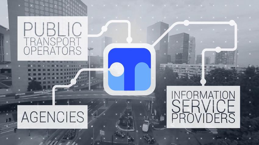
National Access Point in France
Implementation of NAP relying on the existing platform for public data :
NAP is both a data warehouse and a repository:
NAP hostes the static datasets or gives a link allowing to download it
Approach based at first on a voluntary basis
Not only local authorities and transport operators involved, but also information service providers
A step by step approach:
First step: a work with pilot authorities on static data of scheduled services
A second step launched by a « data-MaaS committee » in october 2018 and aiming at :
- exposing static data of all scheduled services :
- dealing with others data: dynamic data of scheduled services, …
- dealing with other transport modes: bike and car-sharing, parking…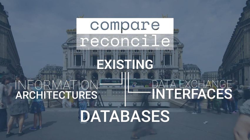
National Access Point
               Current implementation

Pilot local authorities
Static data published
Local authorities contacted
Pending agreement

Pilot Regions
Static data published

Regions contacted
Standards and quality
An open source software available to support the implementation of Netex
Creation of a set of data; data improvement;
conversion from GTFS to Netex
validation : Netex compliance and quality of data
data management
work on national Netex and SIRI profiles
Available profiles : static data, accessibility
to be launched soon:
- SIRI profile, relying on an existing regional profile;
- fares profile
https://transport.data.gouv.fr/
THE   ROLE OF     INSPIRE        IN THE

      PROVISION OF AN          EU-WIDE
      MULTI-MODAL TRANSPORT
       INFORMATION SERVICES
                 (MMTIS)

               Francesco Pignatelli
          European Commission – DG JRC

                Giacomo Martirano
            DG JRC external consultant

DELIVERING EU-WIDE MULTIMODAL TRAVEL
 INFORMATION, PLANNING AND TICKETING
      SERVICES: DREAM OR REALITY

     Bruxelles (BE), 20 Novembre 2018
INSPIRE, Europe’s ”lingua franca” for anything geospatial Directive 2007/2/EC of the European Parliament and of the Council of 14 March 2007 establishing an Infrastructure for Spatial Information in the European Community (INSPIRE)
ISA2 Programme led by the European Commission (DIGIT):
Interoperability Solutions for Government, Businesses and Citizens

                              Reduce administrative
       Breaking silos                burden
                                                          Seamless,
 Digital Single                     Tackling global       end-to-end
    Market         Security       complex challenges     digital public
                                                           services
 Efficiency and
 effectiveness     Interoperability                    Implementation
                                                        of EU policies
                          Once-only
  Public sector
                          principle
  modernisation                              Cross-border by default

                                 Open data        Open by default
     Digital by default
                                                           Standards
                          Transparency
   Single access
       point                                  Accountability
Geospatial data beyond INSPIRE
Digital Single Market
e-Government Action Plan
Tallinn Declaration
Digital Europe
Digital
Interoperability
ISA2
Solutions for European Public Government
Administrations, Businesses and Citizens Technology-enabled
MMTIS innovation and growth
European
Location Geospatial
Interoperability data
Solutions for Studies,
E-Government Frameworks and Standards,
Applications and Pilots,
Services
Location Interoperability for Digital GovernmentG2B ELISE Transportation Pilot Up-to-date flow of road
safety data between
Commercial map providers like HERE and National Road
TomTom need road network data that are Authorities and private
consistent map providers
accurate http://publications.jrc.ec.e
up-to-date uropa.eu/repository/handl
e/JRC104569
In the Transportation Pilot, INSPIRE
standards are used to get geospatial data Published in December
from public administrations 2016
Significant reduced error rates in maps of
from 25% to 7%, and Road Authorities
(SE, NO) upgraded from quarterly to daily
updates to map providers
Commercial map providers able to move
from disparate national processes to more
standardised processes in EU countries
Pilot now being rolled out across Europe
under CEF – Transport (14 countries)
Next step to open solutions to ALL industry
players
https://www.youtube.com/watch?v=jnny5ATwTYE
14INSPIRE support to the Multi-Modal Travel Information Services (MMTIS)
Policy background Actors
ITS Directive Regulation for the provision • DG MOVE – DG JRC collaboration
of EU-wide Multimodal Travel Information • 6 experts for 6 standards
Services (MMTIS) 2017/1926 • ITS and INSPIRE stakeholders
Establishes the specifications necessary for Timeline: Jan 2018 - March 2019
accessibility, exchange and update of
standardised travel and traffic data to Methodology
ensure distributed journey planning for • Identify differences in scope/purpose of the
the provision of MMTIS in the EU different standards involved
• Describe the method for handling of overlaps
Why INSPIRE?
and linking among different standards
Static travel and traffic data shall be
• Provide definitions of the MMTIS data
provided using the INSPIRE requirements,
categories
when related to the spatial networks
• Consult with ITS and INSPIRE stakeholders
Problem statement • Provide recommendations to MS to support
With INSPIRE, other ITS standards should implementation of the ITS regulation, taking
be considered: into account INSPIRE requirements
• What are the overlaps and the links?
Next steps
• What are the options for MS when
• Presentation of INSPIRE-MMTIS project at the
addressing the requirements of the two
3rd Follow-Up Member States Expert Meeting
Directives?
(20th Nov. 2018, Brussels)The role of INSPIRE in the provision of EU-wide MMTIS
INSPIRE
Data Category NAP set-up
definition
Reference Possible source of
Possible contributor
standard for Addresses, Possible source of data to recommendations for NAP
standard for spatial
POIs, etc. be made accessible set-up (metadata, network
networks through NAPs services, validation,
registry, PID, geoportal)Publication
Spatial data categories
deadline
— Location search (origin/destination):
— Address identifiers (building number, street name, postcode)
— Topographic places (city, town, village, suburb, administrative
unit)
— Points of interest (related to transport information) to which
people may wish to travel
— Location search (access nodes):
— Identified access nodes (all scheduled modes)
— Geometry/map layout structure of access nodes (all scheduled
01/12/2019 modes)
— Trip plan computation — scheduled modes transport:
— Connection links where interchanges may be made
— Network topology and routes/lines (topology)
— Stop facilities access nodes (including platform information, help
desks/information points, ticket booths, lifts/stairs, entrances
and exit locations)
— Trip plan computation — road transport (for personal modes):
— Road network
— Cycle network (segregated cycle lanes, on-road shared with
vehicles, on-path shared with pedestrians)
— Pedestrian network and accessibility facilitiesExample of the use of Link, Node, Link Sequence and Link Set
INSPIRE implementation experience, reusable as
additional support to NAP set-up and operation

 Components that can be used as examples and investigated by
 the NAP for their assessment and potential adaptation:

 •   Set-up and operation of an EU geoportal which harvests the NAP
     catalogues and provides a single access point to national datasets

 •   Set-up and operation of a codelist Registry, to support the harmonisation
     of vocabularies

 •   Set-up and operation of a Validation Service allowing MS to self-validate
     their datasets/metadata/network-services

 •   Definition of rules for PID (Persistent Identifiers) management
Want to know more?
ELISE
European Location
Interoperability Solutions
for e-Government
Get started: ELISE Action page
Join and collaborate: ELISE Community
Stay tuned: @EULocation
http://inspire.ec.europa.eu/
The ELISE action is undertaken with the support of ISA².
ISA² is a EUR 131 million programme of the European Commission which develops digital solutions that
enable interoperable cross-border and cross-sector public services for the benefit of public administrations,
businesses and citizens across the EU.
ISA² supports a large range of actions and solutions. The ISA² solutions can be used free of charge and are
open source when related to IT.
ISA² - IT solutions for less bureaucracy You click, we link. Follow us on twitter.
http://ec.europa.eu/isa, ISA@ec.europa.eu
20THE REFERENCE
LANGUAGE FOR
THE PUBLIC
TRANSPORT
DOMAIN
Kasia Bourée
Project Team INSPIRE support to MMTIS/ CEN TC278 WG3 SG4 LeaderTransmodel and the MMTIS Regulation
NATIONAL ACCESS POINT
data
exchange
formats
TAP
INSPIRE NeTEx SIRI TSI
DATEX II
IATA
spatial network rail air road transport
multimodal: road, rail, water, air
urban & long distance transportEASIER INTROPERABILITY
specify
NEW
ROAD INFRASTRUCTURE

           INSPIRE
                                             ROAD TRAFFIC INFORMATION

                                    Measured                              VMS
                                    elaborated
                                       data                             Location
                                           Parking    Situation        Referencing
GDF                                     PUBLIC TRANSPORT
                                        static and dynamic
                            NeTEx                       road, rail, air, water
                                                        scheduled & flexible
                                                        modes
                             SIRI                                                RAIL TRANSPORT
                                                                                   long distance
      AIR TRANSPORT
                             OJP                      alternative modes              TAP - TSI
                                                             Under
                                                             development
See also www.transmodel-cen.eu
NeTEx

                 (christophe.duquesne@aurigetech.com)
                      Normalisation transport
                       Information voyageur

NeTEx Overview                43                        19/11/2018
NeTEx : Exchange format
1. Based on a subpart of Transmodel
• scheduled passenger information
• scheduled operational information
2. Implemented using an exchange
language
mainly XML/XSD, but JSON is possible
3. May simplify some concept in
« views » when all the details
provided by Transmodel are not
required
but MUST stay consistant with Transmodel
NeTEx Overview 44 19/11/2018NeTEx : Exchange format NeTEx Overview 45 19/11/2018
NeTEx : Scope

NeTEx Overview        46         19/11/2018
NeTEx in National access points

                                          NeTEx in
                 GTFS
                            NAPTAN          PTO
                        TransXch
                          ange

                                          NeTEx in
                                            NAP
                 NeTEx at NAP

NeTEx Overview                       47              19/11/2018
NeTEx: Use case examples
To feed journey planner
Any passenger information system feed
Open Data feed (often as an enhanced complement to GTFS)
AVMS feed, as a base for realtime information
Exchange for co-operated network
Late schedule update (on a specific day)
dissemination
Ticketing system feed to update de fare offer
Etc.
NeTEx Overview 48 19/11/2018NeTEx: Profile
A NeTEx profile is a subset of NeTEx dedicated
to a specific use case
A profile
• facilitates the implementation of a standards
• improves interoperability
by
• focusing only on what is needed
• filling the small gaps voluntarily left by the standard
• taking into account the local context.
NeTEx Overview 49 19/11/2018Example of NeTEx usage NeTEx Overview 50 19/11/2018
ENTUR - Norway

NeTEx Overview          51        19/11/2018
ENTUR - Norway

NeTEx Overview          52        19/11/2018
ENTUR - Norway

                    https://en-tur.no/
NeTEx Overview               53          19/11/2018
Ile-de-France Mobilité
More than 80 operators
NeTEx NeTEx SIRI
Realtime
Lines Timetables Stops information
SIRI
Open Data Journey Planner
NeTEx GTFS
NeTEx Overview 54 19/11/2018NeTEx common tool: NeTEx Overview 55 19/11/2018
Christophe Duquesne
                 christophe.duquesne@aurigetech.com

NeTEx Overview                     56                 19/11/2018
Access to Data for a Better Mobility
The TN-ITS Platform
Frank Daems , ERTICOTransport Network – ITS
TN-ITS Vision and Mission

                    Bringing fresher map data to
Vision              intelligent transport services

                  Facilitate and foster the exchange of
Mission          ITS-related spatial road data between
              road authorities as trusted and quality data
                              providers, and,
             data users as map makers and other parties.
The TN-ITS data chain
Data Map makers ITS
Road
Sources Mapmakers
Service
Authorities stations
Providers
Road Authorities publish Map makers retrieve, Drivers can benefit from
changes of road data as verify and integrate these up-to-date fresh map data
part of their SDI changes in their platform in their in-vehicle system,
maintenance and bring this to map stand-alone navigation
users device or smartphonesFocus: Specifications & Deployment
Standardisation Implementation Support
Define & maintain TN- Provide guidelines & tools to
ITS specifications in support implementation in
CEN/TC 278 WG7
Belgium, Finland, France,
Ireland, Norway, Sweden,
and United Kingdom.
CEN/TS17268
(October 2018) TN-ITS GO: + NL, HU, CY, SL,
EE, LT, PT, ES, GRTN-ITS Members
Road
autho-
rities
Map
makers
Support
by
In colla-
boration
withRe-Use at Map & Service Providers Updates of Speed Restrictions near Stockholm in 2 ½ years
TN-ITS Storyboard
2018-2020: CEF
2016-2017: CEF Grant TN-ITS GO:
2013: TN-ITS Pilot EIP A4.7: five nine additional MS:
founded as ERTICO MS: IE, UK, BE/FL, NL, HU, CY, SL, EE,
Platform FI, FR LT, PT, ES, GR
2014-2015: 2017- 2018:
Transportation Pilot CEN TC278
with JRC & EULF: Technical
operational services Specification
NO, SE
CEN/TS17268
Towards TN-ITS services in 15 EU countriesTN-ITS GO : further deployment in EU
• CEF MOVE/B4-2017-63 2M€
Grant
• 20 partners across EU
• First TN-ITS services in nine MS
• Improvement in five existing
implementations
• Pilot services to become fully
operational
• Feedback loop from Map Makers
• New features supporting new use
cases
• Minimum coverage TEN-T
network – ambitions is more!
• Start Jan 2018 – 4 YearsFuture Contribution of TN-ITS
Physical infra (examples) Digital infra (examples)
• the TN-ITS Technical Specification (CEN TS
17278) will be extended to support MMTIS
data 2019
• Place and position of multimodal Hubs
• Type of multimodal transfer possibilities
(being it e.g. metro station, buss-station,
share bike parking,…)
• Static data that provides guidance to e.g.
automated vehicles in this multimodal
approachinfo@tn-its.eu www.tn-its.eu
You can also read