Shire of Woodanilling Bushfire Risk Management Plan 2017 2022
←
→
Page content transcription
If your browser does not render page correctly, please read the page content below

Shire of Woodanilling
Bushfire Risk Management Plan

          2017 – 2022

        Adopted by Council – 18/07/2017
Contents

1.     Introduction .............................................................................................................................. 6
     1.1      Background ....................................................................................................................... 6
     1.2      Aim and Objectives ........................................................................................................... 6
     1.3      Legislation, Policy and Standards ..................................................................................... 6
2.     The Risk Management Process................................................................................................. 7
     2.1      Roles and Responsibilities ................................................................................................ 7
     2.2      Communication & Consultation ....................................................................................... 9
3.     Establishing the Context ......................................................................................................... 10
     3.1      Description of the Local Government and Community Context .................................... 10
       3.1.1         Strategic and Corporate Framework....................................................................... 10
       3.1.2         Location, Boundaries and Tenure ........................................................................... 15
       3.1.3         Population and Demographics ................................................................................ 18
       3.1.4         Economic Activities and Industry ............................................................................ 19
       3.1.5         Cultural Considerations ........................................................................................... 21
     3.2      Description of the Environment and Bushfire Context .................................................. 22
       3.2.1         Topography and Landscape Features ..................................................................... 22
       3.2.2         Climate and Bushfire Season .................................................................................. 24
       3.2.3         Vegetation ............................................................................................................... 25
       3.2.4         Bushfire Frequency and Causes of Ignition............................................................. 31
4.     Asset Identification and Risk Assessment .............................................................................. 34
     4.1      Planning Areas ................................................................................................................ 34
       4.1.1         Priorities for Asset Identification and Assessment ................................................. 34
     4.2      Asset Identification ......................................................................................................... 34
     4.3      Assessment of Bushfire Risk ........................................................................................... 35
       4.3.1         Likelihood Assessment ............................................................................................ 35
       4.3.2         Consequence Assessment ....................................................................................... 36
       4.3.3         Assessment of Environmental Assets ..................................................................... 38
       4.3.4         Local Government Asset Risk Summary.................................................................. 38
5.     Risk Evaluation ....................................................................................................................... 39
     5.1      Evaluating Bushfire risk .................................................................................................. 39
     5.2      Treatment Priorities........................................................................................................ 39
     5.3      Risk Acceptability ............................................................................................................ 39
6.     Risk Treatment ....................................................................................................................... 41
     6.1      Local Government-Wide Controls .................................................................................. 41

     Shire of Woodanilling Bushfire Risk Management Plan 2017 – 2022 V2.0                                                        Page 2 of 77
6.2       Asset-Specific Treatment Strategies ............................................................................... 42
     6.3       Determining the Treatment Schedule ............................................................................ 42
     6.4       Privacy Issues and Release of Information ..................................................................... 43
7.      Monitoring and Review .......................................................................................................... 44
     7.1       Review............................................................................................................................. 44
     7.2       Monitoring ...................................................................................................................... 44
     7.3       Reporting ........................................................................................................................ 44
8.      Glossary .................................................................................................................................. 45
9.      Common Abbreviations.......................................................................................................... 48
10.        Appendices ......................................................................................................................... 50
     Appendix 1 – Legislation, Policy and Standards ......................................................................... 51
     Appendix 2 – Risk Management Process Overview ................................................................... 53
     Appendix 3 – Communications Strategy .................................................................................... 54
     Appendix 4 – Shire of Woodanilling Organisational Structure .................................................. 65
     Appendix 5 – Planning Area Map .............................................................................................. 66
     Appendix 6 – Asset Categories and Subcategories .................................................................... 67
     Appendix 7 – Consequence Ratings ........................................................................................... 69
     Appendix 8 – Local Government-Wide Controls and Multi-Agency Work Plans ....................... 71

     Shire of Woodanilling Bushfire Risk Management Plan 2017 – 2022 V2.0                                                         Page 3 of 77
Amendment List
Version Date Author Section
1.0 12 June 2017 P Cupitt & Initial version submitted to OBRM for
D Morgan compliance review
2.0 16 June 2017 P Cupitt & Renamed section 1.3
D Morgan Amended OEM references
Amended Section 3.1.1
Added Tenure table
Added information on demographics
to section 3.1.3
Amended ‘mitigation zone’ to
‘bushfire management zone’
Amended Section 3.2.1
Added reference re Natural Resource
Zone
Added information to Section 3.2.3
Moved ‘Cultural Considerations’ to
Section 3.1.5
Amended intro to Section 4
Included H&VMB in LG Wide Controls
Comms Strategy:
Added Comms Roles and
Responsibilities of the LG
Amended OBRM role
Publication Information
Wherever a third party holds copyright in material presented in this publication, the copyright
remains with that party. Their permission may be required to use the material.
This document contains Standards Australia Ltd and ISO copyrighted material that is distributed
by SAI Global on Standards Australia Ltd and ISO’s behalf. It may be reproduced in accordance
with the terms of SAI Global Ltd.’s Licence 1411-c083 to the Commonwealth of Australia (“the
Licensee”). All licensed copies of this document must be obtained from the Licensee. Standards
Australia Ltd and ISO’s material is not for resale, reproduction or distribution in whole or in part
without written permission from SAI Global Ltd: tel + 61 2 8206 6355 or
copyright@saiglobal.com.
Shire of Woodanilling Bushfire Risk Management Plan 2017 – 2022 V2.0 Page 5 of 77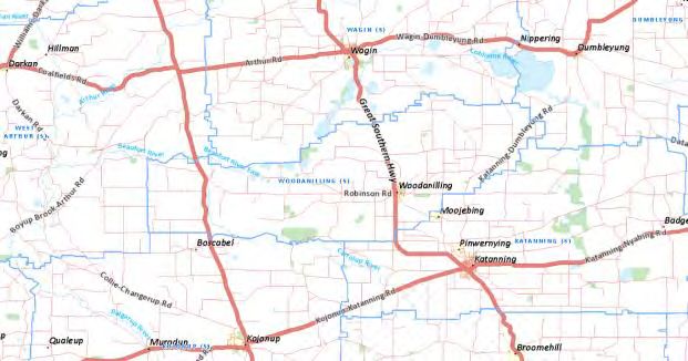
1. Introduction
1.1 Background
Under the State Hazard Plan for Fire (Westplan Fire) an integrated Bushfire Risk Management
Plan (BRM Plan) is to be developed for local government areas with significant bushfire risk.
This BRM Plan has been prepared for the Shire of Woodanilling in accordance with the
requirements of Westplan Fire and the Guidelines for Preparing a Bushfire Risk Management
Plan (Guidelines).
The risk management processes used to develop this BRM Plan are aligned to the key principles
of AS/NZS ISO 31000:2009 Risk management – Principles and guidelines (AS/NZS ISO
31000:2009), as described in the Second Edition of the National Emergency Risk Assessment
Guidelines (NERAG 2015). This approach is consistent with the policies of the State Emergency
Management Committee.
This BRM Plan is a strategic document that identifies assets at risk from bushfire and their
priority for treatment. The Treatment Schedule sets out a broad program of coordinated multi-
agency treatments to address risks identified in the BRM Plan. Government agencies and other
land managers responsible for implementing treatments participate in developing the BRM Plan
to ensure treatment strategies are collaborative and efficient, regardless of land tenure.
1.2 Aim and Objectives
The aim of the BRM Plan is to document a coordinated approach toward the identification,
assessment and treatment of assets exposed to bushfire risk within the Shire of Woodanilling.
The objective of the BRM Plan is to effectively manage bushfire risk within the Shire of
Woodanilling in order to protect people and assets including assets of local value.
Specifically, the objectives of this BRM Plan are to:
Guide and coordinate a tenure blind, multi-agency bushfire risk management
program over a five year period;
Document the process used to identify, analyse and evaluate risk, determine
priorities and develop a plan to systematically treat risk;
Facilitate the effective use of the financial and physical resources available for
bushfire risk management activities;
Integrate bushfire risk management into the business processes of local
government, land owners and other agencies;
Ensure there is integration between land owners and bushfire risk management
programs and activities;
Monitor and review the implementation of treatments to ensure treatment plans
are adaptable and risk is managed to an acceptable level.
1.3 Legislation, Policy and Standards
The legislation, policy, standards and references considered applicable to the development and
implementation of the BRM Plan are detailed at Appendix 1.
Shire of Woodanilling Bushfire Risk Management Plan 2017 – 2022 V2.0 Page 6 of 77
2. The Risk Management Process
The risk management processes used to identify and address risk in this BRM Plan are aligned
with the international standard for risk management AS/NZS ISO 31000:2009. The Shire of
Woodanilling has adopted AS/NZS ISO 31000:2009 throughout the development of the Shire’s
governance framework as detailed in the Corporate Business Plan 2012-2022 (adopted 12
August 2013), noting that some variations may have been applied during the development of
this BRM Plan to best suit the bushfire risk management context. A diagram of the AS/NZS ISO
31000:2009 process is provided at Appendix 2.
2.1 Roles and Responsibilities
The following table outlines the identified key stakeholders for this Bushfire Risk Management
Plan and their roles and responsibilities in line with the development, implementation,
monitoring and review of the BRM Plan and resulting ‘Treatment Schedule’.
Table 1 – Roles and Responsibilities
Stakeholder Name Roles and Responsibilities
Shire of Woodanilling As part of the approval process, submission of the draft
BRM Plan to the Office of Bushfire Risk Management
(OBRM) to review it for consistency with the Guidelines.
As part of the approval process, submission of the final
BRM Plan to council for their endorsement and
adoption.
As custodian of the BRM Plan, coordination of the
development and ongoing monitoring and review of the
integrated BRM Plan and treatment schedule.
Making stakeholders and landowners aware of
identified risks.
Negotiation with land owners to treat risks identified in
the BRM Plan.
As treatment manager, identification and
implementation of treatment strategies.
Department of Fire and Participation in and contribution to the development
Emergency Services (DFES) and implementation of BRM Plans and treatment
schedules, as per responsibilities as the Westplan Fire
Hazard Management Agency (HMA).
Support to local government through expert knowledge
and advice in relation to the identification, prevention
and treatment of bushfire risk.
Facilitation of local government engagement with state
and federal government agencies in the local planning
process.
Undertake treatment strategies, including prescribed
burning on behalf of Department of Lands for
Unmanaged Reserves and Unallocated Crown Land
within gazetted town site boundaries.
Shire of Woodanilling Bushfire Risk Management Plan 2017 – 2022 V2.0 Page 7 of 77
Stakeholder Name Roles and Responsibilities
In accordance with Memorandums of Understanding and
other agreements, implementation of treatment strategies
for other landholders.
Office of Bushfire Risk Under the OBRM Charter, ensure bushfire risk is
Management (OBRM) managed in accordance with AS/NZS ISO 31000.
Reporting on the state of bushfire risk across Western
Australia.
Review BRM Plans for consistency with the Guidelines
prior to final endorsement by council.
Department of Parks and Participation in and contribution to the development
Wildlife (DPAW) and implementation of BRM Plans and treatment
schedules.
Providing advice for the identification of environmental
assets that are vulnerable to fire and planning
appropriate treatment strategies for their protection.
As treatment manager, implementation of treatment
strategies on department managed land and for
Unmanaged Reserves and Unallocated Crown Land
outside gazetted town site boundaries.
In accordance with Memorandums of Understanding and
other agreements, implementation of treatment strategies
for other landholders.
Assist the local government by providing information
Other State and Federal
about their assets and current risk treatment programs.
Government Agencies
Participation in and contribution to the development
Dept of Lands and implementation of BRM Plans and treatment
LandCorp schedules.
Landgate As treatment manager (where applicable), identification
Main Roads WA and implementation of treatment strategies.
Dept of Education
Dept of Aboriginal Affairs
Forest Products Commission
Water Corporation
Dept of Water
Assist the local government by providing information
Public Utilities
about their assets and current risk treatment programs.
Western Power Participation in and contribution to the development
and implementation of BRM Plans and treatment
schedules.
As treatment manager, identification and
implementation of treatment strategies.
Assist the local government by providing information
Corporations and Private Land
about their assets and current risk treatment programs.
Owners
Participation in and contribution to the development
Telstra and implementation of BRM Plans and treatment
Rail schedules.
Shire of Woodanilling Bushfire Risk Management Plan 2017 – 2022 V2.0 Page 8 of 77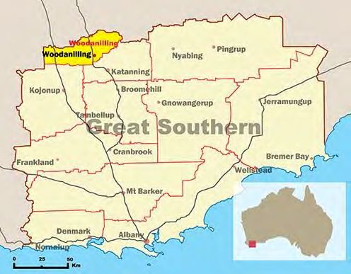
Stakeholder Name Roles and Responsibilities
Agriculture As treatment manager, identification and
Private Land Owners implementation of treatment strategies.
Participation in and contribution to the development
Other
and implementation of BRM Plans and treatment
Chief Bushfire Control Officer schedules.
(CBFCO) Providing advice for the identification of assets that are
Bushfire Advisory Committee vulnerable to fire.
(BFAC) Providing advice on appropriate treatment strategies
District Operations Advisory for asset protection.
Committee (DOAC)
Local Emergency
Management Committee
(LEMC)
Bushfire Brigades (BFB’s) and
other Emergency Services
Volunteers
Landcare
South West Aboriginal Land
and Sea Council
Wagyl Kaip Corporation
2.2 Communication & Consultation
As indicated in Appendix 2, communication and consultation throughout the risk management
process is fundamental to the preparation of an effective BRM Plan. To ensure appropriate and
effective communication occurs with relevant stakeholders throughout the life of this plan,
including during the development, implementation and review phases, a Communication
Strategy has been prepared. The strategy is provided at Appendix 3.
Shire of Woodanilling Bushfire Risk Management Plan 2017 – 2022 V2.0 Page 9 of 77
3. Establishing the Context
3.1 Description of the Local Government and Community Context
3.1.1 Strategic and Corporate Framework
The Shire of Woodanilling has a Strategic Community plan (2012 – 2022) and a Corporate
Business Plan 2012 - 2022 (adopted 2013) both of which feature a strong ‘community safety’
focus, reflect the Shire’s commitment to this end and confirm that the BRM Plan will be a
valuable document that, once endorsed, should integrate easily into existing Shire planning
frameworks.
The Strategic Community Plan and Corporate Business Plan reflect themes and objectives in the
following areas:
1. Social
o Community Facilities
o Community Well-being
2. Environmental
3. Civic Leadership
o Law & Order
o Customer Service
o Governance
4. Economic
Upon review of the Strategic Community Plan and Corporate Business Plan, the following
themes, goals and actions are identified as having direct relevance to the objectives of this BRM
Plan, with the primary focus on protecting “people, assets and other things of local value” 2:
THEME 1 SOCIAL Community Well-Being (CW)
CW 3 Expand Fire Awareness
Promote fire awareness in the community
Utilise CESM to support programs and assisting in sourcing funding for
programs
Fire awareness educational/ promotional program
Brigade support program
CW 10 Ensure significant heritage buildings and places under Councils care
and/or ownership are preserved and where possible restored
Identify buildings of significant heritage value
Prepare Heritage Management Plan(s)
2
Strategic Community Plan (2012 – 2022)
Shire of Woodanilling Bushfire Risk Management Plan 2017 – 2022 V2.0 Page 10 of 77CW 11 Develop Community Pride programs that are reflected by the high
standard of maintenance and development of private properties within
the town
Needs assessment and program establishment
THEME 2 ENVIRONMENT (EN)
EN 1 Restore and protect natural environment and landscape
Roadside weed control
Weed control in reserves
Revegetate roadsides to reduce weed burden
Protect landscapes and remnant bushland
EN 2
Undertake roadside conservation survey and develop plans for future re-
vegetation works on roadside areas to enhance ecological value and natural
aesthetics
EN 6 Increase capacity of community to implement Natural Resource
Management (NRM) and Improve NRM information
Develop local clearing policies and develop and distribute educational
information to include environmentally sensitive and community high priority
areas
THEME 3 CIVIC LEADERSHIP Law & Order (LO)
LO 2 Implementation of Fire Management Plan
Support Bush Fire Advisory Committee and local Brigades
Annual review of Woodanilling Townsite Fire Management Plan
Utilise CESM to support programs
Support education programs
Implement recommendations from Townsite Fire Management Plan
LO 6 Local Emergency Management to ensure preparedness for local
emergencies
Review Local Emergency Management Arrangements
Continue involvement with Shires of Katanning and Kent for local emergency
management and utilise CESM to develop joint and local strategies
THEME 3 CIVIC LEADERSHIP Customer Service (CS)
CS 6 Enhance the image of the Shire and establish a relationship with the
public to reflect credibility on the organisation.
Develop adopt and implement Communication Strategy and
Identify and liaise with key community members
Shire of Woodanilling Bushfire Risk Management Plan 2017 – 2022 V2.0 Page 11 of 77THEME 3 CIVIC LEADERSHIP Governance (GO)
GO 2 Preparation of Land Use Strategies for town and rural areas
Identify existing and forecast future land uses within the Shire
GO 6 Preparation of relevant local laws as determined by community need.
Identify need and develop required new local laws
GO 10 Implementation of community consultation processes that link the
Council and the community to ensure open and accountable government.
GO 11 Corporate Risk Management Plan
Develop and Implement a Corporate Risk Management Plan
The following functions within the Shire of Woodanilling’s administration team have been
identified as having specific roles and responsibilities in line with the successful implementation
of the BRM Plan.
Table 2: Functions within the Shire of Woodanilling with roles and responsibilities associated to the Bush Fire Risk
Management Plan
Function Roles & Responsibilities
Oversight of the implementation, review and
Corporate Leadership Team
monitoring of the Bushfire Risk Management Plan
Sourcing and approving funding and expenditure
Ensure implementation and review of the Bushfire Risk
Management Plan
Monitoring the implementation of agreed treatments
Liaison with key stakeholders
Participation on Local Emergency Management
Committee (LEMC)
Develop practices for fire management on LG, UCL and
Person Tasked with
UMR land
Emergency Management
Planning annual schedule of works
within the Shire
Build knowledge and understanding of fire
Administration Team
management practices within the community
Participation on Bushfire Advisory Committee (BFAC)
Support bushfire meetings and committees
Oversee burning programs and support from local
brigades
Contributing to treatment planning
Negotiating with stakeholders
Shire of Woodanilling Bushfire Risk Management Plan 2017 – 2022 V2.0 Page 12 of 77Chief Bushfire Control Oversee burning programs and support from local
Officer brigades
Contributing to treatment planning
Negotiating with stakeholders
Fire breaks inspection and enforcement
Works Department Undertake planned works
Planning Ensure adherence to building codes
Bushfire prone mapping
Finance Accessing grants and funding
NOTE: Some functions outlined above are fulfilled through the employment of contract
personnel.
A copy of the organisational structure is attached at Appendix 4.
The Shire of Woodanilling was identified as a priority local government in the first round of
funding arrangements for the WA State Government’s Bushfire Risk Management Project. This
resulted in the temporary appointment of a Bushfire Risk Planning Coordinator (BRPC) and
Bushfire Risk Management Officer (BRMO) using project funding managed through the
Department of Fire and Emergency Services (DFES). The role of the BRPC and BRMO was to
assist the Shire to develop a Bushfire Risk Management Plan including a comprehensive Asset
Risk Register and Treatment Schedule. Both the BRMO and BRPC positions were funded until 30
June 2017.
The Shire, supported by the Department of Fire and Emergency Services (DFES), currently has
access to the services of a Community Emergency Services Manager (CESM). This position is
managed by a Memorandum of Understanding (MOU) and is a shared resource between
Woodanilling and neighbouring Shires. A significant role of the CESM is to ensure the Shire’s
Volunteer Bush Fire Brigades and other Emergency Management Volunteers are supported,
trained, equipped and capable of providing appropriate fire services to the community. 3 It was
also envisaged that the CESM position would have a key role throughout the implementation,
monitoring and review phases of this BRM Plan once the plan is endorsed. At the time of
finalising this plan, the term of the CESM MOU was concluding (July 2017) with negotiations
ongoing in relation to the future of the position within the Shire. The CESM position has strong
support from the emergency services volunteers including the Bushfire Advisory Committee and
the Chief Bushfire Control Officer4 however given the changing priorities, funding limitations
and political landscape the CESM position may not be able to be supported into the future.
Should this position not continue the CESM responsibilities will be allocated to the ‘person
tasked with emergency management within the Shire’.
The Shire of Woodanilling recognises the importance of leadership and coordination in
emergency management and has an established Local Emergency Management Committee
(LEMC) with multi agency membership. This committee provides an important forum to enable
consultation around the BRM Plan.
3
Memorandums of Understanding – Provision of a shared Community Services Manager, July 2014
4
Shire of Woodanilling Council Meeting – Minutes – May 2017
Shire of Woodanilling Bushfire Risk Management Plan 2017 – 2022 V2.0 Page 13 of 77The LEMC has endorsed Local Emergency Management Arrangements (LEMA) for the Shire. In
the development of the LEMA, the Committee undertook a risk assessment process resulting in
a ‘Risk Treatment Schedule and Plan’ being developed that outlines identified risks, risk levels
and treatment options. The Shire of Woodanilling ‘Risk Register reflects Bushfire as a ‘high’ risk
to the Shire.
The Shire also has an active Bushfire Advisory Committee (BFAC). The BFAC membership
reflects considerable bushfire fighting knowledge and experience. This forum has been integral
to the development of the plan and will continue to be a key stakeholder in the implementation
and review of the plan.
In 2013 the Shire had a Fire Management Plan commissioned, with a focus on the Woodanilling
townsite, confirming the Shire’s commitment and proactive approach to Bushfire Risk
Management. In addition to the townsite plans primary aim of “managing the bush fire threat
within and around the townsite and to ensure that the community (life), residences and
infrastructure (property) and areas of conservation and heritage value (environment) are
protected from fire” 5, the plan also details further objectives being:
Reduction in fire incidents
Preparation and implementation of an annual works program
Improved compliance with Councils firebreak notice
Improved community awareness and acceptance of fire management and hazards
Greater membership of local volunteer bush fire brigades
Improved inter agency cooperation in hazard management 6
This plan further identifies that:
The most likely risk of ignition will be from human activity, either accidental or
deliberate.
Based upon fire history there is a ‘likelihood’ that there may be a localised bush fire
within the vicinity of the townsite with the consequences dependent upon how aware
and prepared the community and landowners are.
The principle bush fire threat relevant to the townsite is a grass/scrub fire.
The assessment of existing development in the townsite, in compliance against the
‘Planning for Bush Fire Protection’ performance criteria, highlights little separation
between the vegetated areas, with an extreme hazard rating, and existing residential
development.
There are no formal hazard separation zones between areas of high fire danger and
residential areas.
Management of vacant land, with absentee owners, is an ongoing concern.
Unallocated Crown Land (UCL) is not well managed 7
It is important to note that whilst the 2013 plan focusses on the Woodanilling townsite, not the
Shire as a whole, the recommendations detailed in the Woodanilling Townsite Fire Management
Plan have been incorporated into this BRM Plan which reflects a broader ‘whole of Shire’
approach. These recommendations focus on:
5
Woodanilling Townsite Fire Management Plan, February 2013, TME Town Planning Management Engineering Pty Ltd
6
Woodanilling Townsite Fire Management Plan, February 2013, TME Town Planning Management Engineering Pty Ltd
7
Woodanilling Townsite Fire Management Plan, February 2013, TME Town Planning Management Engineering Pty Ltd
Shire of Woodanilling Bushfire Risk Management Plan 2017 – 2022 V2.0 Page 14 of 77 Strategic fire breaks
Access ways.
The local primary school, which presently caters to less than 20 students, was placed on the
Education Departments ‘Bushfire Risk Register’ in 2011. An independent risk assessment was
undertaken in 2015 with a number of recommended treatments identified. These were
completed in early 2016. The school has developed a Fire Management Plan in accordance with
Department of Education requirements. It is interesting to note that the original Woodanilling
Primary School was lost to fire in July 1949. 8
3.1.2 Location, Boundaries and Tenure
Woodanilling is named after a spring in the Boyerine Creek one kilometre south of the townsite.
The Shire is located approximately 3 hours (290 km) from Perth, 2.5 hours from Bunbury and 2
hours Albany. The Shire of Woodanilling is situated on the south-western edge of the Wheat
Belt region in the Central Great Southern region of Western Australia and is linked by the Great
Southern Railway line which was an important transport route for the early colony.
9
Figure 1 – Location of the Shire of Woodanilling
The Shire of Woodanilling is 1126 square kilometres and contains approximately 107 kilometres
of sealed roads and 415 kilometres of unsealed roads.
8
Website: Trove, National Library of Australia, sourced 23 May 2017, www.trove.nla.gov.au
9
Website: http://www.gsdc.wa.gov.au/our-region/local-governments/shire-of-woodanilling/
Shire of Woodanilling Bushfire Risk Management Plan 2017 – 2022 V2.0 Page 15 of 7710
Figure 2 – Shire of Woodanilling Geographic Statistics
The Shire is bordered by the local government authorities of West Arthur, Wagin, Dumbleyung,
Katanning and Kojonup.
11
Figure 3 – Location of the Shire of Woodanilling and surrounding Shires
The main localities within the Shire are Beaufort River, Boyerine, Glencoe, Cartmetricup,
Kenmare, Westwood and Woodanilling Town.12
The Woodanilling town site contains the shire council administration centre and depot, a
general store, a primary school, a well-equipped recreation/ function centre, an historic two
storey tavern, a caravan park, an archery park and a grain receivable site.
There are 4 major transport routes through the Shire, including:
Albany Highway
Robinson Road
Great Southern Highway
Katanning / Dumbelyung Road
10
Strategic Community Plan 2012 - 2022
11
Website: Google Maps
12
Website: Shire of Woodanilling Website, Council and Community Hand in Hand
Shire of Woodanilling Bushfire Risk Management Plan 2017 – 2022 V2.0 Page 16 of 77Bushfire incidents impacting any of these routes have the potential to create concerns for the
Shire of Woodanilling as well as surrounding Shires, particularly in the context of vehicle
movement around the Great Southern Region.
13
Figure 4 – The Townsite of Woodanilling
Tenure
Within the Shire of Woodanilling, Department of Parks and Wildlife have approx. 1.2% of
tenure. Significant land in the Shire is vested to private landownders predominantly
agriculturally based. The other tenures in the Shire are combination of Local Government,
Department of Lands, Deptartment of Water, Forest Products Commission and a range of other
private owners. There are parcels of Unallocated Crown Land (UCL) and Unmanaged Reserves
(UMR) in the townsite of Woodanilling. The Shire has 1328 hectares of Nature Reserve which
equates to 1.2% of the Shires total area. 14
Table 3 – Overview of Land Tenure and Management within the Shire of West Arthur
Land Manager/Agency* % of Plan Area
Local Government 1.2%
Department of Parks and Wildlife 1.2%
Other – i.e. Department of Lands 3.7%
Private Land Owners (Agriculture) 93.9% 15
Total 100%
13
Source: DFES Mapping System (FESMaps)
14
Website: Australian Bureau of Statistics www.abs.gov.au
15
Website: Australian Bureau of Statistics www.abs.gov.au
Shire of Woodanilling Bushfire Risk Management Plan 2017 – 2022 V2.0 Page 17 of 773.1.3 Population and Demographics
An article published on 14 April 2016, in The Australian Business Review, titled “Growth and
Loss: how Australia is being reshaped” makes the observation that “great swathes of population
loss is spreading across Australia’s farmlands punctuated by growth in places like Woodanilling”.
This observation is supported by the WA Department of Planning document ‘West Australia
Tomorrow, Population Report No 7, 2006 to 2026, February 2012’, that predicts at least a 1%
annual growth increase in Woodanilling until 2026. This goes against the trend of declining
population in many regional areas.
The most recent Australian Bureau of Statistics (ABS) data is from 2015. This reflects the
population of Woodanilling as 422. The median age, of 38.3 years, is in line with the national
average of 37.4 years.
The majority of the Shire’s population is concentrated around the townsite of Woodanilling
although, as the Shire is predominantly agriculturally focused, some of the population is
dispersed throughout the Shire’s broad acre farms. Many of the families in the Woodanilling
Shire are long term generational farming families and there is minimal cultural diversity.
16
Figure 5 –Shire of Woodanilling Demographics
The 2011 Census data reflects that 206 residents of the Shire were employed with 48.1%
engaged directly within the Agricultural Industry, 7.3% engaged in Manufacturing, Construction
and Public Administration and Safety respectively.
The age profile for the Shire varies from the State and National averages in the 15 – 29 year age
group, which can be explained by people moving away from the area for educational purposes.
This age group in particular may raise concerns in line with succession planning within the local
Emergency Services Brigades. The 45 – 49 age group is noticeably higher than the State and
National averages. The unemployment rate of 2.4% is lower than both the State and National
averages of 4.7% and 5.6% respectively.
The 2011 ABS Census reflects that 37.7% of the total population over the age of 15 are engaged
in some form of volunteer work, this includes those engaged as Emergency Services Volunteers.
This rate is significantly higher than both the State and National averages that sit at 16.9% and
17.8% respectively. This statistic is noteworthy as fire response within the Shire is solely
undertaken by volunteer emergency services personnel.
16
Website: Australian Bureau of Statistics www.abs.gov.au
Shire of Woodanilling Bushfire Risk Management Plan 2017 – 2022 V2.0 Page 18 of 7717
Figure 6 –Shire of Woodanilling Age Profile, Census 2011
In the context of the four stages of emergency management – Prevention, Preparation,
Response and Recovery18, the Shire of Woodanilling has a strong and proactive approach to
bushfire response. As bushfire events can directly impact a farmer’s livelihood, colloquially ‘if
the smoke goes up’ the response will be strong and fast with farmer response units arriving from
neighbouring farms and further afield. The downside to this is that anecdotal evidence suggests
that records reflecting the number of fires in the region are not accurate as not all fires are
reported.
With statistics reflecting that 25% of the Shires population are registered Emergency Services
Volunteers, this bodes well for the Shire as this would infer that 25% of the community would
have at least some level of awareness, and therefore increased appreciation of bushfire risk and
what to do when there is a fire. When it comes to preparatory efforts (i.e. in line with
prevention and preparedness), community engagement is a little more challenging; mainly due
to time constraints, conflicting priorities and the tyranny of distance. Nevertheless, compliance
in line with landowner responsibilities, detailed in the Shire’s annual Bush Fire Notice, is
generally good.
3.1.4 Economic Activities and Industry
The Shire of Woodanilling is predominantly a sheep and grain producing area and these
industries continue to be the Shire’s economic mainstay. Agricultural activities are dominated
by grain, wool and sheep with beef and pigs also increasing in prominence. In recent years, a
sheep and goat meat abattoir, agroforestry, a dolomite (lime) fertilizer business and other
agricultural based export markets have been added to the mix.19
17
Website: Australian Bureau of Statistics www.abs.gov.au
18
Shire of Katanning, Woodanilling and Kent Local Emergency Management Arrangements, Oct 2016
19
Website: Shire of Woodanilling Website www.woodanilling.wa.gov.au
Shire of Woodanilling Bushfire Risk Management Plan 2017 – 2022 V2.0 Page 19 of 77Farms are generally getting bigger or becoming increasingly diverse in order to remain profitable
with most farms expanding to undertake both crop and livestock ventures as well as exploring
less traditional activities such as pig and goat farming. Agriculture has been the primary
industry within the Shire since the mid 1800’s, needless to say; agriculture continues to be
vitally important to the local economy.
In the period 2012 – 2015, 68% of the businesses in the Shire of Woodanilling were Agricultural
enterprises. 14% of businesses were in the rental, hiring and real estate industries and 4% in
the Manufacturing Industry, 4% in Construction, 4% in Financial and Insurance Services and 4%
in Accommodation and Food Services. 20
21
Figure 7 –Shire of Woodanilling Economic Profile, Census 2011
In 1996/97 the gross value of agricultural production (GVAP) for the Shire was in the vicinity of
$19 Million, there were 67 registered farms and the area of land used for farming was 90.5% of
the Shires land area. 22 Comparatively, in 2001, the GVAP was $19.9 Million, an increase of
4.7%. In 2006, the GVAP was $25.9 Million, an increase of 30%, with farming enterprises making
up 93.9% of the Shires land tenure. 23
24
Figure 8 – Shire of Woodanilling Agricultural Commodities, 2006
The Local Emergency Management Arrangements note that the predominant agricultural
activities occur between May – July, which is the seeding season, with harvest occurring
between November to January.
20
Website: Australian Bureau of Statistics www.abs.gov.au
21
Website: Australian Bureau of Statistics www.abs.gov.au
22
Source: Agricultural Statistical Overview 96/97, July 2000, Department of Agriculture WA
23
Website: Australian Bureau of Statistics www.abs.gov.au
24
Website: Australian Bureau of Statistics www.abs.gov.au
Shire of Woodanilling Bushfire Risk Management Plan 2017 – 2022 V2.0 Page 20 of 77In a bushfire context, whilst the shire may be seen as lower risk of bushfire due to somewhat
lower fuel loads in comparison to traditional high risk areas such as forests, the peak of the
harvest season coincides with the high risk summer periods. There is a heightened risk of fires
starting during the harvest period with cropping practices potentially resulting in ignition.
Stubble burning, post cropping, increases the possibility of accidental escapes and increased
ignitions as a result of machinery (i.e. Headers). Modern harvesters have many potential
ignition sources which need to be carefully managed. Bearings, hot exhausts, turbochargers,
electrical circuits and belts combined with dry straw, dust, chaff, oil and leaking distillate
provide the perfect environment for fire. The movement of these vehicles through cured grain
paddocks means this is the most likely time for a farm fire. There is also risk of spontaneous
ignition within hay stacks, hay sheds and chaff heaps. Crop fires tend to have a very rapid rate
of spread.25 There is also increased concern that farming practices, and therefore fire risk, can
change dramatically year to year dependent upon what activities are likely to be the most
profitable for the farmer.
The economic impact of fires on agricultural holdings should not be underestimated with
potential costs associated with machinery replacement, stock and crop losses including feed and
grazing pastures as well as massive curbs on agricultural production in following seasons.
Studies from the Black Saturday (Victorian) Fires show that Agricultural impacts were found to
be the highest contributor to total losses at 25%.26 A more recent crop fire, in 2015 in Adelaide,
resulted in “tens of thousands of hectares of crops, livestock and expensive farm machinery”
being destroyed. The economic loss to farmers was estimated to be over $100 million dollars. 27
The Shire has controls in place pursuant to the Bush Fires Regulations 1954, to reduce the risk of
crop related bushfires; these controls are reviewed annually by the Bushfire Advisory
Committee (BFAC). This risk is further reduced once harvest is completed and the paddocks
opened to grazing. However the risk is increased as result of the drive to explore alternative
crops as some crops (i.e. canola or rapeseed) burn at a higher temperature and can be harder to
extinguish and mop up. The risk is also increased as farmers move to employ innovative farming
practices and technology.
The Shire has six bridges located around the region, the majority of which are timber
construction and are therefore considered a strategic risk. Some of these bridges are located
along significant routes and have the potential to impact movement around the area should
they be impacted by fire, with economic impacts also likely.
3.1.5 Cultural Considerations
The Shire has 224 assets deemed to have cultural significance that are listed on the Heritage
Council of WA ‘InHerit’ Register. One of these, the ‘Carrolup Bridge’ is listed on the State
Heritage Register as a ‘place of State significance’ and is therefore protected under the Heritage
of Western Australia Act 1990. 28
25
Source: Department of Fire and Emergency Services (2014), Homeowner Bushfire Survival Manual, pp. 37
26
Source: Estimating the net cost of the 2009 Black Saturday Fires to the affected regions - C. Stephenson, Centre for Risk
and Community Safety, RMIT University and Bushfire CRC, J. Handmer, Centre for Risk and Community Safety, and A.
Haywood, Department of Sustainability and Environment, Victoria
27
Website: www.adelaidenow.com.au Farmers in Mid-North start counting loss from Pinery fire devastation, A, Hough,
The Advertiser, November 27, 2015
28
Website: http://inherit.stateheritage.wa.gov.au/Public/Search
Shire of Woodanilling Bushfire Risk Management Plan 2017 – 2022 V2.0 Page 21 of 773.2 Description of the Environment and Bushfire Context
3.2.1 Topography and Landscape Features
Topography impacts this BRM Plan as it contributes to risk by influencing fire rate of spread
(ROS), intensity and because of the potential for the terrain to impede access for suppression
forces. The risk associated with topography is considered in the context of access, as a variable
in predicting fire behaviour and in the calculation of the bushfire management zone for each
community/asset.
The Shire is located within the Yilgarn Craton. The Shire is a combination of ancient gneiss
(course grained rock), porphyritic granitoid (glassy rock) and even grained granitoid (crystalline
rock) with a cover of alluvium in the major valleys. Generally the basement rocks are mantled
by a lateritised, deeply weathered profile. To the east of the Shire, the sandplain soils of the
ancient plateau are extensively preserved. To the west, greater stripping of the landscape has
produced shallow duplex soils formed on the lateritic profile and results in the surface drainage
system being better defined than that to the east. 29
On the ground, the landscape reflects as ‘gently undulating’ with vast expanses of seemingly
level terrain. This tends to indicate that response would not necessarily be impeded by the
nature of the topography.
The map below reflects the geological characteristics of the area:
30
Figure 9 – Shire of Woodanilling Geology
The townsite is situated in a shallow broad valley with the Boyerine Creek running through
town. The topography is generally undulating with gradients of less than 10%. A small ridge
and exposed granite outcrops are located on the northern edge of the townsite where the
Whispering Winds Estate is located. 31 A key consideration associated with these granite
29
Native Vegetation Handbook for the Shire of Woodanilling, S Grein, 1994
30
Website: GeoVIEW.WA www.geoview.dmp.wa.gov.au
31
Woodanilling Townsite Fire Management Plan, February 2013, TME Town Planning Management Engineering Pty Ltd
Shire of Woodanilling Bushfire Risk Management Plan 2017 – 2022 V2.0 Page 22 of 77outcrops is the potential for this terrain to draw lightning strikes with weather factors (such as
lightening) having been identified as the most significant contributor to fire occurrences in the
Shire.
All of the Shire is located in the Blackwood River Catchment and is drained by the upper reaches
of the Carolup and Carlecatup Rivers. Chains of wetlands and lakes occur naturally across the
landscape.
Bushfire Prone Mapping
The intent of the WA Governments Bushfire Prone Planning Policy is to implement effective risk
based land use planning and development to preserve life and reduce the impact of bushfire on
property and infrastructure.32 The State Planning Policy 3.7 – Planning for Bushfire Prone Areas
relates to the protection of future assets and, whilst this BRM Plan focuses on improving
protection of existing assets, the Map of Bush Fire Prone Areas has been included as it provides
a useful framework for analysing fire risk and a means of validating the risk assessments made,
and ratings applied, within this BRM Plan.33
The Bushfire Prone areas are shown in ‘pink’ on the map below. The map identifies areas that
are designated as subject to, or likely to be subject to, bushfire attack. Where a bush fire prone
area cuts across a portion of a parcel of land, the entire parcel is considered to be Bush Fire
Prone. Bush Fire Prone areas are subject to new planning and construction requirements.
These are addressed through the Shire of Woodanilling Town Planning Scheme.
34
Figure 10 – Map of Bush Fire Prone Areas within Woodanilling Shire
32
WA State Planning Policy 3.7 – Planning in Bushfire Prone Area, Dec 2015
33
Guidelines for Planning in Bushfire Prone Areas, WA Dept of Planning, Version 1.1, February 2017
34
Source: Map of Bush Fire Prone Areas 2016 – Dept of Fire and Emergency Services
Shire of Woodanilling Bushfire Risk Management Plan 2017 – 2022 V2.0 Page 23 of 773.2.2 Climate and Bushfire Season
The Shire of Woodanilling is described as having a Mediterranean type climate, experiencing
cool winters and long, hot summers. Winter months are characterised by cold fronts that
generate in the Southern Ocean. Winds tend to come from the west and north-west. Rainfall in
the Wheatbelt generally decreases from west to east. 35
The following table reflects the annual climatic conditions for the Shire of Woodanilling over the
period 2016 – 2017:
36
Table 3: Annual Climatic Conditions 2016 – 2017 – Woodanilling Weather Station
The following table provides the monthly weather conditions during 2016/2017:
37
Table 4: Monthly Climatic Conditions (2016/2017) – Woodanilling Weather Station
Please note that these statistics are taken from the Woodanilling Weather Station that has only been active
since April 2016.
Bushfire risk is determined by the combination of a number of factors including climatic
conditions such as air temperature, relative humidity, wind speed and rainfall. Bushfire threat is
typically associated with very hot (above average temperatures), dry (less than 20% humidity)
and windy (above 12 – 15 Km per hour) conditions and high fuel loads. Climatic data provides
an indication of fuel availability for bushfires throughout the year, but in particular during the
fire season, and is used to calculate the Fire Danger Index (FDI), and thereby the associated
likely fire behaviour. This data is also used to determine the Southern WA fire season.
35
Woodanilling Townsite Fire Management Plan, February 2013, TME Town Planning Management Engineering Pty Ltd
36
Website: Department of Agriculture and Food - www.agric.wa.gov.au/weather-stations
37
Website: Department of Agriculture and Food - www.agric.wa.gov.au/weather-stations
Shire of Woodanilling Bushfire Risk Management Plan 2017 – 2022 V2.0 Page 24 of 77The Southern WA fire season is typically from November through to April with the Shire of
Woodanilling determining their ‘Restricted Burning’ times as follows:
19th September to 31st October: Restricted Burning (permits required)
1st November to 14th February: Prohibited Burning
15th February to 15th April: Restricted Burning (permits required)
The Bush Fires Act 1954, sections 17 and 18, provides for the ‘declaration and gazettal’ of
Prohibited and Restricted Burning Times as well as the ability to adjust burning times to suit
changing weather conditions.
3.2.3 Vegetation
The total area of native vegetation in the Shire of Woodanilling has been significantly reduced
through rapid broad scale clearing for agricultural purposes. However, much of the native
vegetation that remains in public reserves and on private land is similar in composition to that
which existed previously, although the extent of the cover has been significantly reduced. 38
Only around 16% of remnant vegetation remains, of which only 3% is within conservation
estates or State Forest. 39
The vegetation in large areas of the town and especially along the creek lines is characterised by
Jam Wattles (Acacia acuminata) and Sheoaks (Casuarina obesa). The Sheoaks usually occur with
closely packed narrow trunks with a dense understory which often has weed infestation. On the
higher land there are areas of White gum (Eucalyptus wandoo) and Salmon gums (Eucalyptus
salmonophloia). 40
Woodanilling is within the boundaries of the Blackwood River Catchment. Within the Shire the
catchment gives rise to a number of lakes and many seasonal water courses. Prior to the 1940s
these lakes were relatively fresh and supported a diverse variety of vegetation and animal life
but with extensive clearing of native vegetation to allow for agricultural development, these
lakes are now saline. With the removal of naturally occurring vegetation, the hydrology of the
region has changed dramatically. Ground water is rising through the subsoil to the surface,
transporting salts contained within the soil profile with it. Increasing salinity within soils and
water bodies is now a major problem throughout the Wheatbelt. Woodanilling is one of the
most salt affected areas in Western Australia’s south-west with more than 15% of land in the
area lost to salinity with a further 15% of remnant vegetation and agricultural land at high risk of
salinisation between now and 2026. 41
The South-west of Western Australia has been divided into districts, called Natural Resource
Zones (NRZ), 42 on the basis of their natural resources i.e. vegetation type, drainage/catchment
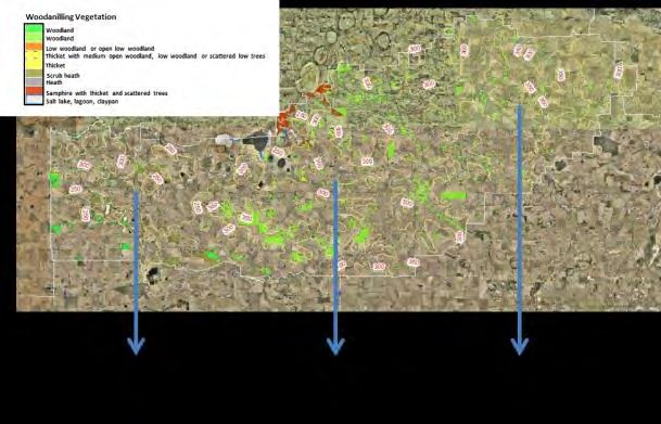
system and rainfall. The Shire of Woodanilling contains a mosaic of vegetation types, from
three zones, which are discussed below. These include the Beaufort Vegetation System, the
Wagin Vegetation System and the Dumbleyung Vegetation System.
38
Native Vegetation Handbook for the Shire of Woodanilling, S Grein, 1994
39
Source: Landscapes of the Upper Blackwood, South West NRM Strategy, www.swnrmstratety.org.au
40
Woodanilling Townsite Fire Management Plan, February 2013, TME Town Planning Management Engineering Pty Ltd
41
Source: Wagin Woodanilling Landcare, NRM WA, Project 14045 submission
42
Native Vegetation Handbook for the Shire of Woodanilling, S Grein, 1994
Shire of Woodanilling Bushfire Risk Management Plan 2017 – 2022 V2.0 Page 25 of 7743
Figure 11 – Woodanilling Vegetation Types and Systems
The Beaufort Vegetation System covers a small area in the western edge of the Shire.
Sandy deposits occur along sections of the Carrolup River and carry a variety of plant
communities. The principle elements of this vegetation system landscape are woodland
of wandoo and York gum and wandoo on undulating country and woodland of York gum
and flat-topped yate (Eycalyptus occidentialis) on sandy patches. Often there is a mosaic
of different combinations of Eucalyuptus spp. (including Marri) woodland on a variety of
landscapes. 44
The Wagin Vegetation System covers the entire Shire in a belt from Beaufort River Flats
to Woodanilling. The landscape is undulating and well dissected with only small
remnants of laterite cappings on ridges, some granite domes and broad valleys
containing salt marshes. The dominant vegetation is comprised of a mosaic of brown
mallet (Eucaluptus astringens) and wandoo (Eucalytptus wandoo) woodland on laterite
mesas and low woodland of York gum (Eucalyptus loxophleba) and wandoo on the slopes
of undulating country. Brown mallet was joined by red morrel (Eucalyptus longicornis)
near the townsite of Woodanilling. Heaths occur on scattered patches of laterite,
occasionally associated with wandoo, but more frequently with the Drummond’s gum
(Eucalyuptus drummondii). Dryandra spp. are generally the dominant species in heath
vegetation. 45
The Dumbleyung Vegetation System is the most prominent System in the Blackwood
Catchment and covers the eastern third of the Shire of Woodanilling. In the Shire, the
landscape is gently undulating. Woodlands of York gum (Eucalyptus loxophleba) and
43
Map Source: Conservation Science Western Australia Journal, Department of Parks and Wildlife, Volume Nine, Number
One, October 2013, the vegetation of Western Australia at the 1:3,000,000 scale. Explanatory memoir. Second edition. JS
Beard, GR Beeston, JM Harvey, AJM Hopkins and DP Shephard.)
44
Native Vegetation Handbook for the Shire of Woodanilling, S Grein, 1994
45
Native Vegetation Handbook for the Shire of Woodanilling, S Grein, 1994
Shire of Woodanilling Bushfire Risk Management Plan 2017 – 2022 V2.0 Page 26 of 77wandoo (Eucalyptus wandoo) occupy the undulating country with Drynadra spp. scrub
on the laterite residual. Brown (Eucalyptus astringens) mallet woodland and low
woodland occur on weathered laterite residuals and slopes. Woodlands formed are
ether mallet or York gum, salmon gum, morrell and wandoo. 46
In the context of bushfire risk, of particular note in relation to the Woodanilling townsite, are
the abundant sheoaks. The volume of sheoaks, and the density of scrub, increases the potential
for a fire to impact the Woodanilling townsite with the sheoaks potentially acting as a ‘wick’ to
draw the fire into the town settlement.
Environmental Considerations – Flora and Fauna
Flora and Fauna represent particular significance for the Shire as they are not only recognised
environmental assets in their own right, but also impact the treatment options available for
identified risks in relation to other assets.
A recent study titled ‘A Resilient Blackwood Basin in a Changing Climate Concept Plan, February
2013’ states the following in relation to threats to the Blackwood Basin: “Bushfire and its positive
effects on native vegetation are well known. Of concern however, is the lack of knowledge and an
appropriate Fire Management Plan specific to the catchments within the region that are aimed at
preserving life, conserving native vegetation and reducing the influx of invasive species. Conflicting
information exists which requires a major investment in time and resources to ensure a best
management approach is taken. Little is understood of post-fire management which has seen a rapid
invasion by weedy grasses into once pristine bushland, further increasing the risk of fire in the
future. 47
”
All treatments need to be assessed in line with the requirements of the identified flora and
fauna. As an example, one of the Declared Rare Flora located within the Shire - ADENANTHOS
PUNGENS SUBSP EFFUSA Nelson – indicates fire management as follows:
48
Figure 12 – Fire Management of Declared Rare Flora – Adenanthos Pudgens Subsp Effusa Nelson
Appropriate authorities and subject matter experts must be consulted prior to any risk
treatment works commencing.
A further consideration in relation to both bushfire mitigation and response strategies is the
potential spread of Phytopthora Cinnamomi (Dieback). Dieback has infected large areas of
Jarrah forest. It is easily spread through soil movement from vehicles, animals, water and feet.
Other fungal-borne diseases can also be spread through these pathways. This risk must be
considered in the context of planned prevention and response strategies and the risk minimised
wherever possible. The Shire has also identified a number of noxious weeds including, Wild
Oats, Barley Grass, Stinkwort, Cape Tulip, Soursob, Four O’Clock, Wireweed and Bridal Creeper.
Any treatments need to minimise the potential spread of disease or unwanted plants. 49
46
Native Vegetation Handbook for the Shire of Woodanilling, S Grein, 1994
47
A Resilient Blackwood Basin in a Changing Climate Concept Plan, February 2013
48
Declared Rare Flora in the Katanning District, Department of Conservation and Land Management, 2000
49
Website: Shire of Woodanilling www.woodanilling.wa.gov.au
Shire of Woodanilling Bushfire Risk Management Plan 2017 – 2022 V2.0 Page 27 of 77You can also read