"Reducing flood risk, sustaining communities, enabling growth" - Flood Risk Management Plan
←
→
Page content transcription
If your browser does not render page correctly, please read the page content below
East Riding of Yorkshire

Flood Risk
Management Plan
2015-2021

Kingston upon Hull and
Haltemprice Catchment within
East Riding of Yorkshire

    "Reducing flood risk,
  sustaining communities,
      enabling growth"

                           i
ii
E A S T R I D I N G O F YO R K S H I R E

 FLOOD RISK MANAGEMENT PLAN

     K I N G S TO N U P O N H U L L A N D
H A LT E M P R I C E C AT C H M E N T W I T H I N
     E A S T R I D I N G O F YO R K S H I R E

                            2015-2021

                  DECEMBER 2015

                 ©2015 East Riding of Yorkshire Council. All rights reserved.
          No part of this publication may be reproduced in any form or by any means
            without the prior permission of the East Riding of Yorkshire Council.

                                                                                      iii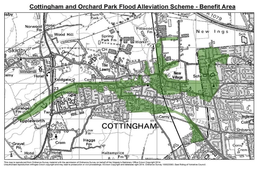
Contact information

For further information about this Flood Risk Management Plan,
please contact us using the details below.

Andrew McLachlan – Principal Engineer, Flood Risk Strategy

Angela Cowen – Senior Flood Risk Strategy Officer

Tel: 01482 391705

Email: floods@eastriding.gov.uk

Web: www.eastriding.gov.uk/flooding

Post: Flood Risk Strategy, County Hall, Beverley, HU17 9BA

                                                                 iv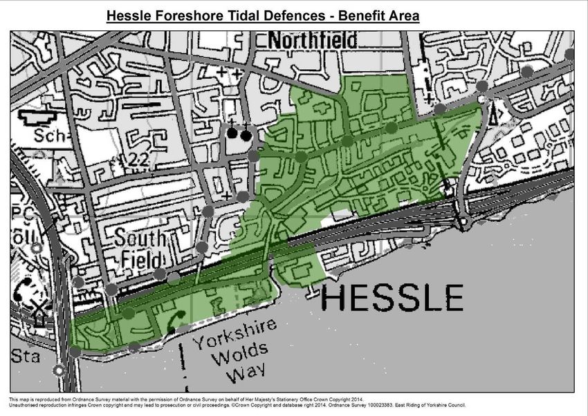
EXECUTIVE SUMMARY

Introducing the Flood Risk Management Plan
This document is the Flood Risk Management Plan (FRMP) for an area in the East Riding of Yorkshire
which forms part of the ‘Kingston upon Hull and Haltemprice catchment’. It is the first of a series of
FRMPs being prepared by East Riding of Yorkshire Council (the Council) for catchments across the
whole of the East Riding of Yorkshire, as part of its role as a Lead Local Flood Authority (LLFA).

In developing its LLFA role, the Council has produced a Local Flood Risk Management Strategy
(LFRMS). This sets out strategic priorities and actions for managing flood risk within the whole of
the East Riding of Yorkshire up to 2027 and beyond. The FRMPs are intended to support the
LFRMS by identifying more detailed measures such as site-level schemes that will reduce flood risk
to communities in each catchment. A plan showing the geographical extent of the catchments,
defined by areas in which rainfall drains to the North Sea or Humber Estuary upon striking the
ground, is provided in Figure 1 (Section 1.1).

The Kingston upon Hull and Haltemprice catchment
The Kingston upon Hull and Haltemprice catchment contains the city of Kingston upon Hull and
the area to the west of the city, which includes the ‘Haltemprice’ villages of Cottingham, Anlaby,
Willerby, Kirk Ella and Hessle, part of the village of Swanland and the village of Skidby. It also
includes the western part of the village of Bilton, which lies to the north east of Hull. Because this
catchment is at particularly high risk of surface water flooding, as witnessed in the Summer of 2007
when 11,335 properties are recorded to have flooded within this catchment (7,888 within Kingston
upon Hull and 3,447 within the Council’s area), it has been designated as a Relevant Flood Risk
Area1.

This means that this Council and Kingston upon Hull City Council (KHCC) have duties under the
2009 Flood Risk Regulations to produce a FRMP to address the significant flood risk in this
catchment, by December 2015. The two councils have thus developed respective plans for the
catchment, recognising the importance of considering flood risk management on a catchment basis.
The boundary of the catchment and that of the area covered by this FRMP are shown in Figure 2.

The Council has also worked with other risk management authorities (RMAs) that have specific
statutory duties and powers for managing flood risk in the FRMP area, including the Environment
Agency, Beverley and North Holderness Internal Drainage Board and Yorkshire Water.

Assessing flood risk
The FRMP considers the risk of flooding posed by all sources and how this may change in the future
as a result of factors such as new development and climate change. It considers how this risk is
currently being managed by RMAs, and reviews relevant strategies, plans and programmes being
progressed by RMAs and others regarding future approaches to flood risk management in the
FRMP area.

To improve understanding of flood risk in the catchment, the Council and KHCC jointly
commissioned an integrated catchment model using specialist computer software. This replicates
the catchment’s hydrology and provides an accurate simulation of the complex interactions
between inland watercourses, sewerage systems, pumping infrastructure and the sea. The resultant
surface water flood risk mapping is afforded a high confidence rating, providing a strong evidence
base against which the Council and other organisations can plan flood risk measures, such as where

1
 The 2009 Flood Risk Regulations define a Relevant Flood Risk Area as “(a) the flood risk area identified by the LLFA under regulation
14(1) or (b) if a referral is made to the Minister, the flood risk area determined by the Minister under regulation 14(6)
                                                                                                                                         v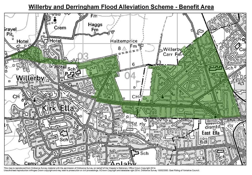
to build new flood mitigation schemes, where to allocate land for future development, and
conducting reviews of emergency plans.
Key flood risk issues
In summary, the key flood risk issues for the FRMP area are:
All types of flood risk are present, with some receptors at risk from multiple sources of
flooding. There is a substantial amount of people and property at risk within the Haltemprice
settlements, and the risk is expected to increase in the future due to climate change. There is a
strong dependence on flood defence and drainage infrastructure to mitigate this risk. Flood
forecasting and warning are also crucially important, however the current elective uptake to
the Environment Agency’s Flood Warning Service among residents and businesses is relatively
low.
The amount of maintenance activity undertaken on flood defence and drainage infrastructure is
currently less than what would normally be scheduled, due to sustained Government cuts to
the Environment Agency’s revenue budget in recent years.
There are recurrent flooding incidents associated with intense storms and limitations in the
capacity of the sewerage network in the FRMP area, particularly in Cottingham.
The Environment Agency and the Council are progressing schemes to manage the risk of tidal,
fluvial and surface water flooding. For instance, the Council is pursuing a number of large flood
alleviation schemes that will reduce the risk of surface water flooding to the Haltemprice
settlements. In addition Yorkshire Water has identified, through feasibility studies, some high
level notional solutions to increase the level of protection from the drainage system. However,
the costs associated with these are significant and will require further development by all RMAs
to enhance business cases for investment, both independently and jointly. The company has
stated that capital investment to improve the capacity of the public sewer network in the
catchment will only take place in the current 5 year investment cycle (2015-2020) where there
is a strong investment case, based on prioritised risk across all of Yorkshire. Currently
investment is prioritised where customers have previously suffered internal flooding at their
property in less than a 10% annual exceedance probability (AEP) (1 in 10 year) event.
A significant amount of new development is proposed in the area – effective Sustainable
Drainage Systems (SuDS) are important to ensure this does not add to flood risk. For major2
development proposals it will be essential to ascertain that the sewerage system has capacity to
receive additional foul flows without causing the risk of surcharge, sewage escape or flooding
within the proposed development or elsewhere in the catchment.
A number of water bodies in the area are failing to achieve ‘good’ ecological status or potential
under the Water Framework Directive due to flood risk management approaches.
Future management
The FRMP sets out a number of measures to address flood risk in the FRMP area, most of which
are to be implemented within the first reporting cycle for FRMPs (2015-21), based on what is
understood to be reasonably achievable from a legal, technical, and financial point of view, as well as
reflecting the aspirations of stakeholders and local community. They contribute to achieving the
strategic objectives set out in the LFRMS, which aim to reduce the probability of flooding and its
impacts on people, the economy and the wider environment in the East Riding of Yorkshire as a
whole. The FRMP measures supplement those in the LFRMS, and primarily relate to the delivery of
capital schemes, including the planned improvements to flood defences on the Humber and
2 Major development is defined in the National Planning Policy Framework as 10 or more dwellings.
vi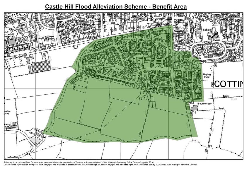
construction of new flood alleviation schemes in Cottingham, Willerby and Anlaby, improving
maintenance arrangements for existing flood risk assets, enforcing local development policies,
piloting property level protection, and improving community awareness and pro-activity regarding
flooding.

Delivery of this FRMP will require the support and ongoing commitment from all relevant partners.
The FRMP will be subject to regular monitoring and periodic review, using economic, social and
environmental indicators to ensure that the FRMP is contributing to the sustainability of the area as
far as possible.

                                                                                                  vii
viii
Location map: East Riding of Yorkshire

                            ix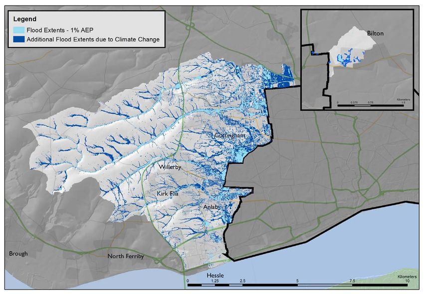
CONTENTS

Executive Summary .................................................................................................................................................................. v
Figures and Tables ................................................................................................................................................................... x
1        Introduction .................................................................................................................................................................... 1
2        Spatial Characteristics ................................................................................................................................................... 5
3        Flood Risk Overview ................................................................................................................................................... 13
4        Key Flood Risk Issues .................................................................................................................................................. 29
5        Future Management ..................................................................................................................................................... 31
6        Monitoring and Review ............................................................................................................................................... 43
7        Glossary ......................................................................................................................................................................... 47
8        References ..................................................................................................................................................................... 51
Appendix A: Flood Risk Assets ........................................................................................................................................... 53
Appendix B: Integrated Catchment Model Technical Note.......................................................................................... 63
Appendix C: Approach to Assessing Flood Risk Receptors ......................................................................................... 75
Appendix D: Flood Alleviation Scheme Indicative Information.................................................................................... 77

                                                                                                                                                                                           x
FIGURES AND TABLES
Figure 1 Hydraulic catchments in the East Riding of Yorkshire..................................................................................... 1
Figure 2 FRMP area and wider Kingston upon Hull and Haltemprice catchment boundaries ................................ 2
Figure 3 Haltemprice watersheds ......................................................................................................................................... 5
Figure 4 Geology, soil and source protection zones........................................................................................................ 7
Figure 5 Heritage assets ......................................................................................................................................................... 8
Figure 6 Environmental designations ................................................................................................................................... 9
Figure 7 Economic and social infrastructure .................................................................................................................... 10
Figure 8 Map of previous flooding events......................................................................................................................... 15
Figure 9 Overall extent of flood risk (all sources) .......................................................................................................... 17
Figure 10 Recent flood alleviation schemes ..................................................................................................................... 22
Figure 11 Flood Warning Areas .......................................................................................................................................... 25
Table 1 Critical Infrastructure ............................................................................................................................................. 11
Table 2 Previous flooding ..................................................................................................................................................... 14
Table 3 Key statistics - Flood Risk in the FRMP area ..................................................................................................... 18
Table 4 Investment needs to provide increased protection in the drainage network ............................................ 23
Table 5 Humber Flood Risk Management Plan - Measures for the FRMP Area....................................................... 26
Table 6 Key issues in relation to managing flood risk in the FRMP ............................................................................ 29
Table 7 Monitoring Framework .......................................................................................................................................... 43
Table 8 Performance indicators and targets .................................................................................................................... 45
xiAppendices
Table A1. FRAR categories 53
Table A2. Flood risk assets in the FRMP area 54
Table A3. Existing hydrometric data sources 61
Table B1. Boundary conditions applied to integrated model 63
Table B2. Proposed development sites 65
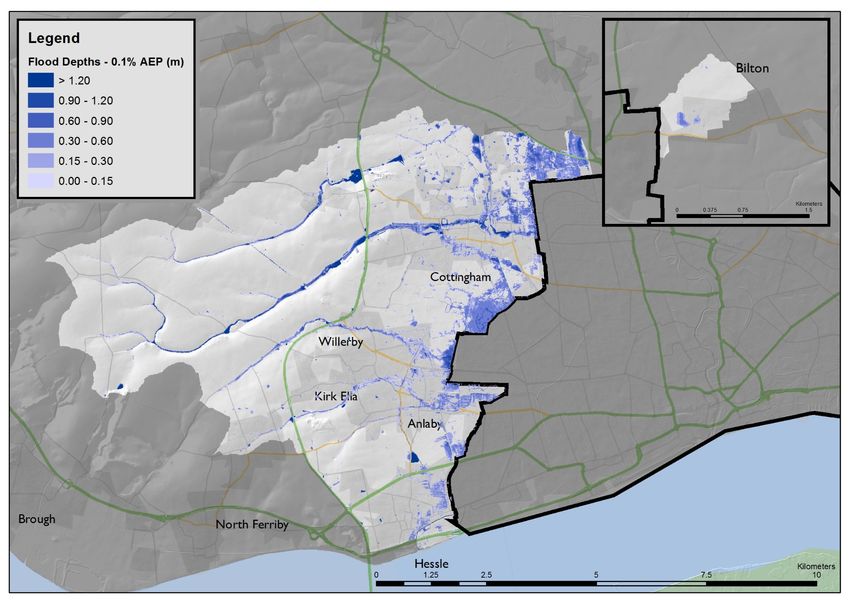
Figure B1. 3.3% AEP (1 in 30 year) flood extent and depths 67
Figure B2. 1% (1 in 100 year) flood extent and depths 68
Figure B3. 0.1% AEP (1 in 1,000 year) flood extent and depths 69
Figure B4. 1% (1 in 100 year) flood hazard 70
Figure B5. Impact of future development on the 1% AEP (1 in 100 year) flood extent 71
Figure B6. Impact of climate change on the 1% AEP (1 in 100 year) flood extent 72
Figure B7. Flood risk map - 1% AEP (1 in 100 year) 73
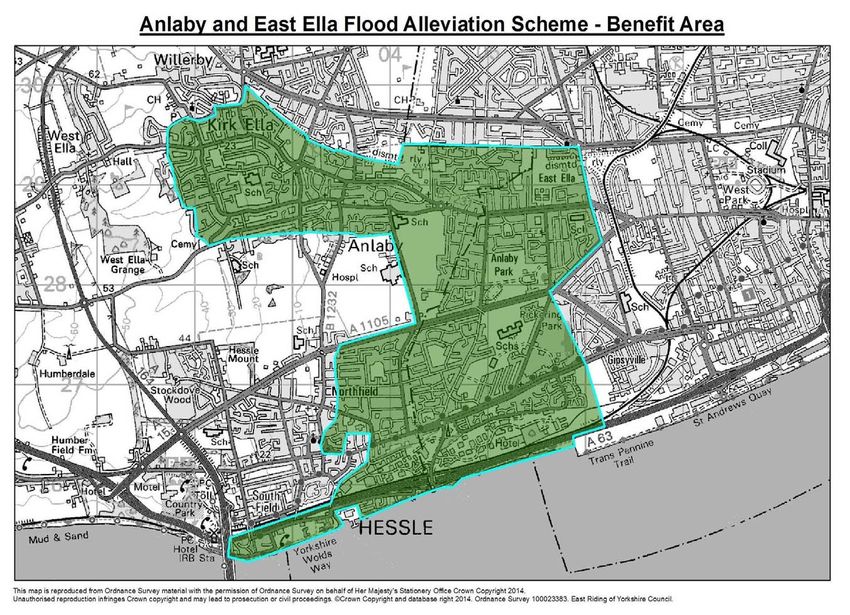
Figure D1. Anlaby and East Ella Flood Alleviation Scheme – Benefit Area 77
Figure D2. Cottingham and Orchard Park Flood Alleviation Scheme – Benefit Area 78
Figure D3. Willerby and Derringham Flood Alleviation Scheme – Benefit Area 79
Figure D4. Castle Hill Flood Alleviation Scheme – Benefit Area 80
Figure D5. Skidby Village Flood Alleviation Scheme – Benefit Area 81
Figure D6. Hessle Foreshore Tidal Defences – Benefit Area 82
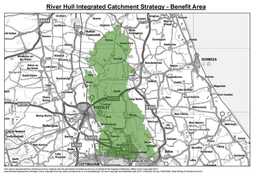
Figure D7. River Hull Integrated Catchment Strategy – Benefit Area 83
xiiWillerby and Derringham Flood Alleviation Scheme, 2015. Copyright ERYC
xiii1 INTRODUCTION
1.1. What is the Flood Risk Management Plan for the Kingston upon
Hull and Haltemprice catchment (within East Riding of
Yorkshire)?
1.1.1. The Flood Risk Management Plan (FRMP) for the Kingston upon Hull and Haltemprice
catchment (within East Riding of Yorkshire) is one of a series of such FRMPs being
prepared by East Riding of Yorkshire Council (the Council) for individual hydraulic
catchments across the East Riding of Yorkshire, in its capacity as Lead Local Flood
Authority (LLFA)3. These hydraulic catchments are shown in Figure 1. This FRMP applies
to part of a geographical area known as the Kingston upon Hull and Haltemprice
catchment. This is one of 10 national ‘Relevant Flood Risk Areas’ designated by DEFRA,
due to the high concentration of people and property at significant risk of surface water
flooding.
Figure 1 Hydraulic catchments in the East Riding of Yorkshire
1.1.2. When the catchment is referred to in this document, it relates to the Kingston upon Hull
and Haltemprice catchment as defined for the Flood Risk Regulations 2009 and includes
the administrative area of Kingston upon Hull as well as part of the administrative area of
the East Riding of Yorkshire (13,638 hectares in area). References to the FRMP area relate
to the part of the catchment that lies exclusively within the East Riding of Yorkshire
(6,452 hectares in area). The ‘catchment’ is referred to where there is relevance or
3 The Flood and Water Management Act 2010 designates all upper-tier local authorities as LLFAs, giving them lead
responsibility for managing the risk of flooding from surface water, groundwater and ordinary watercourses to provide
for better, more comprehensive management of flood risk for people, homes and businesses in their administrative
areas.
1commonality in both administrative areas. The boundaries of these areas are shown in
Figure 2.
Figure 2 FRMP area and wider Kingston upon Hull and Haltemprice catchment boundaries
1.1.3. This FRMP supports the Council’s LFRMS, which sets out what the Council intends to do
working with organisations, businesses and communities to manage the risk of flooding in
the whole of the East Riding of Yorkshire over the next decade and beyond. It should
therefore be read alongside the LFRMS to give a full picture of the Council’s approach to
flood risk management in the area. The FRMP presents additional measures specifically in
the FRMP area based on a detailed assessment of the flood risks in the catchment.
1.1.4. Together with the LFRMS, this FRMP fulfils statutory requirements set out in the Flood
and Water Management Act 2010 (F&WMA) and the 2009 Flood Risk Regulations4. It has
been informed by national policies and guidance including the National Flood and Coastal
Erosion Risk Management Strategy (Defra, 2011) and national guidance on preparing
FRMPs5. It has also been informed by local policies and plans, previous consultations, and
the findings of the Strategic Environmental Assessment (SEA) and Habitat Regulations
Assessment (HRA). As such it is intended to represent the priorities of all.
4 These Regulations transpose the European Floods Directive into domestic law. Details of how the statutory
requirements have been met are set out in Table A1 of the Local FRM Strategy.
5 Flood Risk Management Plans: How to Prepare them (Defra et al, May 2014)
21.2. How has the FRMP been Prepared?
1.2.1. In preparing the FRMP, a wide range of information has been considered to ensure that it
is based on sound evidence and is cognizant of all relevant factors that influence flood risk
management in the catchment. Of particular note are the legislative requirements which
specify what the FRMP must address and how it must be prepared, as well as legislation
that stipulates how flood risk management functions should be carried out (see Appendix
A of the LFRMS for an overview of relevant legislation). The FRMP also takes into account
key policies and plans from a national, sub-national and local level, including the National
Flood and Coastal Erosion Risk Management Strategy, flood risk management plans
produced by the Environment Agency and neighbouring LLFAs, and other relevant plans
such as the East Riding Local Plan. The governance structure and partnership working
arrangements have also influenced the content of the FRMP, as have current levels and
availability of funding from different sources.
1.3. Environmental assessments
1.3.1. Because the FRMP is a statutory document that may influence land use decisions (like the
Council’s Local Plan and Local Transport Plan) its proposals must be formally assessed in
accordance with European legislation6 to identify whether they are likely to have any
significant effects on the environment, society and/or the economy. The findings of this
exercise are presented in an Environmental Statement Report for the East Riding of Yorkshire
Local Flood Risk Management Strategy and have been taken into account in developing the
FRMP.
1.3.2. In addition, the FRMP has been subject to a Habitat Regulations Assessment in accordance
with the Habitat Regulations and Conservation of Habitats and Species Regulations 2010.
The details of this process are set out in an Addendum to the Habitats Regulations
Assessment of the Local Flood Risk Management Strategy: Screening Report for the Kingston
upon Hull and Haltemprice Flood Risk Management Plan (June 2015) and the Habitat
Regulations Assessment Appropriate Assessment Report for the Kingston upon Hull and
Haltemprice Flood Risk Management Plan (September 2015).
1.4. Consultation
1.4.1. A draft of the FRMP was subject to a public consultation in March-April 2015 with a draft
LFRMS to ensure that all interested parties had the opportunity to comment on and
influence the content of these documents. They were accompanied by a Draft
Environmental Statement Report and Draft Habitat Regulations Assessment (HRA) Stage 1
Screening Report. Details of the consultation are provided in the Report of the Consultation
on the Local Flood Risk Management Strategy and Kingston upon Hull and Haltemprice Flood
Risk Management Plan, which sets out the responses received and how these have been
taken into account in developing final versions of the documents.
6 European Directive 2001/42/EC
34 Coastguard intervention in Anlaby, June 2007. Copyright ERYC
2        SPATIAL CHARACTERISTICS

2.1.     Introduction
2.1.1.   This section provides an overview of the social, economic and environmental
         characteristics of the FRMP area.

2.2.     Topography and Hydrology
2.2.1.   The topography of the FRMP area ranges from 163.6m above ordnance datum (AOD)
         (above average sea level) near Cave Wold in the north-west, to around 0m AOD in the
         New Ings area on the western edge of Hull. There are a number of distinct sub-
         catchments or ‘watersheds’ along the edges of the Wolds, which channel water from
         agricultural land through the Haltemprice settlements towards the city’s western
         boundary, where the land becomes flatter. These are shown in Figure 3. The precipitation
         that falls on the FRMP area ultimately drains into the Humber Estuary principally via the
         public sewerage system by means of pumping at Hull Waste Water Treatment Works.

         Figure 3 Haltemprice watersheds

2.2.2.   In the north of the FRMP area, the watershed known as Cottingham Parks is drained via
         the Wanlass Beck/Mill Beck and Creyke Beck, flowing southward into Cottingham and
         converging near Victoria’s Way where along with the Broadlane Beck they flow into the
         Cottingham Branch sewer, which connects to the Northern Trunk Sewer. The Broadlane
         Beck serves the Raywell Valley which is the largest of the watersheds, starting at
         Brantingham Top.

2.2.3.   To the north east of Cottingham is low carr land known as the Northmoor catchment.
         This drains to the culverted Cottingham Drain and then to the Northern Trunk Sewer

2.2.4.   To the south of Cottingham, a network of drains / watercourses serving the Willerby
         Carrs watershed connects to the Northern Trunk Sewer via Setting Dyke at Windsor
                                                                                                 5
Road, Hull. The Great Gutter Valley watershed discharges to the Acres Heads Drain
system (Great Gutter Drain – Sand Dyke – Acre Heads Drain) which starts at Great
Gutter Lane West before taking a complex route and eventually discharging to the
Humber via Hessle Fleet Drain and Hessle Haven.
2.2.5. The Westella Valley watershed discharges via the Western Drain system (Easenby Drain –
Western Drain) which starts to the east of Swanland before passing through Kirk Ella,
Anlaby and Hessle. At Anlaby and Hessle flows are joined from the southernmost
Watershed known as Tranby Hill, before eventually discharging to the Humber via Hessle
Fleet Drain and Hessle Haven.
2.2.6. Hessle Fleet Drain discharges to the Humber via manual and mechanical sluices at Hessle
Haven. However this can only occur during low tides so the watercourse and its
tributaries have to rely on their own capacity to drain the area during high tides. There is
apparatus for a demountable pump to be installed at the sluice structure to discharge
water to the Humber if the water levels are posing a flood risk.
2.2.7. To the east of the catchment within Bilton, Bilton Drain is the main watercourse in the
western part of the village. This connects to the Bilton Trunk Sewer just to the west of
the village. The remainder of Bilton is drained via surface water sewers connecting to the
Old Fleet Drain, which lies outside the FRMP area.
2.2.8. The water that drains into the public combined sewer network within the Haltemprice
settlements and in the western parts of Hull travels mostly by gravity to a large
underground structure known as a mixing chamber which is situated directly adjacent to
West Hull pumping station at Goulton Street, Hull. Before improvements where made in
2001, flows once discharged via the West Hull Pumping Station directly to the Humber.
However flows now drop into a deep ‘Humbercare’ tunnel which carries storm and
sewerage flows across the city.
2.2.9. From Bilton and East Hull, flows in the combined public sewerage system travel to
another mixing chamber just to the north of east Hull pumping station before dropping
into the Humbercare tunnel. East Hull pumping station previously discharged flows
directly to the Humber in a similar way to that of West Hull Pumping Station.
2.2.10. The Humbercare tunnel terminates at Hull Waste Water Treatment Works where a
series of submersible pumps lift sewage into the head-works of the plant. In dry weather
conditions (which includes for light and medium rainfall) up to 2m3/s is presented to the
plant for full biological treatment before treated waste water is discharged to the
Humber. In storm conditions larger submersible pumps can be brought on line to
discharge both screened and unscreened sewerage directly to the Humber. All discharge
is subject to a regulatory consent. In total the pumping station at the waste water
treatment works can deliver an installed discharge design capacity of around 21m3/s of
sewage and storm water to the Humber.
2.2.11. Where there is a requirement to discharge flows directly to the Humber, such as in an
emergency situation, and in order to avoid danger to life or health7, both West and/or
East Hull pumping stations can be activated to remove excess flows from the public
sewerage system. This is only likely to occur if the capacity of the system is or has been
exceeded during exceptional conditions of if there is a catastrophic failure of the
Humbercare Tunnel. The installed discharge design capacity of West and East Hull
pumping stations is around 16m3/s and 28m3/s respectively giving a total pumping capacity
7 S89 (1) (a), (b), (c) Water Resources Act 1990
6for the entire catchment of up to around 65m3/s or 65 tonnes per second dependent on
conditions.
2.3. Geology and Soil
2.3.1. The FRMP area is founded on bedrock of white chalk, the majority of which is overlain
with glacial till, except for the eastern part of Cottingham, which is overlain with river
terrace deposits. This transition between till and alluvial deposits roughly coincides with
the administrative boundary of Kingston-upon-Hull. Large aquifers, used for public
drinking water supply, are present in the chalk. In order to protect these from
contamination, a large proportion of the FRMP area lies within Groundwater Source
Protection Zones. The extents of these are shown on Figure 4.
2.3.2. The soils in the FRMP area are ground water gleys that have been drained, resulting in
agricultural land use classifications of Grades 2 and 3.
Figure 4 Geology, soil and source protection zones
2.4. Cultural heritage and landscape
2.4.1. The landscape of the FRMP area is rural and suburban in character. Rural land uses
provide the setting for the Haltemprice settlements, which are predominantly arable
although some fields are used for grazing, especially for horses. The field boundaries are
generally hedgerows, although the condition of these varies. Clumps of mature trees
within the hedgerows and gardens help to integrate the edges of the Haltemprice
settlements with the surrounding landscape. The field pattern is a combination of random
and regular fields indicating both early and parliamentary enclosure. There is evidence of
mediaeval cultivation in places in the form of moated sites and small areas of ridge and
furrow.
72.4.2. Recreation facilities, such as golf courses, sports pitches, school playing fields, cemeteries
and hospitals scattered throughout the Haltemprice settlements also contribute to the
landscape character of the FRMP area.
2.4.3. To the north of Cottingham, landscape character is influenced by the horticultural
industry, where there are several glasshouses. The landscape around the village of Bilton
is predominantly arable with a stark interface between development and the countryside.
Fields are medium to large in size and are regular in field pattern, with boundaries marked
by hedgerows and drainage ditches.
2.4.4. Within the villages of Cottingham, Kirk Ella, West Ella, Hessle, Swanland and Skidby, there
are conservation areas to protect their historic character and features. Cottingham's
conservation area includes Thwaite Park, a Registered Historic Park and Garden, which
provides an important landscape setting for the urban area, and a Scheduled Monument
(the site of the former Baynard Castle). There is also a Scheduled Monument to the north
of Springhead Park Golf Course in Willerby - the site of the former Haltemprice Priory.
2.4.5. There are also numerous listed buildings in the FRMP area; notable examples include St
Mary's Church in Cottingham and St Andrew's Church in Kirk Ella, both Grade 1 listed,
and Skidby Mill, Grade II* listed.
2.4.6. In addition to these formal designations, the FRMP area is rich in cultural and heritage
assets of local significance, and as recent excavation works for surface water attenuation
schemes in the area have shown, there is still much to be discovered in terms of assets of
national and local importance.
2.4.7. The nationally designated heritage assets in the FRMP area are shown in Figure 5.
Figure 5 Heritage assets
82.5. Biodiversity and water quality
2.5.1. The natural habitats and ecology in the FRMP area have declined over time as urban
expansion and agricultural intensification have occurred along with associated land
drainage, although there are some remaining pockets of woodland and examples of
neutral unimproved grassland at Priory Meadows and Snuff Mill Fields (between
Cottingham and Willerby). The ponds in the area support amphibians including great
crested newt and some ditches support water voles. The grasslands support a range of
flora and fauna including barn owls.
2.5.2. The Humber Estuary, which forms the southern boundary of the FRMP area, is recognised
internationally for its nature conservation value. It supports significant numbers of birds
and other wildlife including grey seals, river lamprey, sea lamprey and intertidal habitats
including mudflats and saltmarsh. It is designated as a Ramsar Site under the International
Convention on Wetlands of International Importance especially as Waterfowl Habitat. It
is also designated a Special Protection Area (SPA) under the European Birds Directive, a
Special Area of Conservation (SAC) under the European Habitats Directive, and a Site of
Special Scientific Interest (SSSI) under the Wildlife and Countryside Act.
2.5.3. Under the Water Framework Directive (WFD), the Humber Estuary is classified as a
heavily modified waterbody with ‘moderate’ ecological quality and ‘failing’ chemical quality.
The Hessle Fleet Drain is also classified as a heavily modified waterbody, with moderate
ecological quality. It has not been assessed for chemical quality.
2.5.4. The environmental designations and the WFD status of water bodies in the FRMP area
are shown in Figure 6.
Figure 6 Environmental designations
92.6. People and economy
2.6.1. The population of the FRMP area is estimated at 62,800 (and c329,100 for the whole
catchment). The main concentrations of population in the FRMP area are the Haltemprice
settlements of Cottingham (c17,500), Anlaby/Willerby/Kirk Ella (c23,500) and Hessle
c(15,000), as well as smaller villages including Skidby and Swanland, and the western part
of the village of Bilton.
2.6.2. The residents in the FRMP area enjoy a relatively high quality of life, with some
neighbourhoods ranked among the 10% most affluent or ‘least deprived’ areas in the
country8. These are found in Cottingham, Willerby Kirk Ella, Hessle and Swanland.
2.6.3. Figure 7 shows the location of some of the main economic and social assets /
infrastructure in the FRMP area. The main industrial and commercial sites in the FRMP
area include Priory Park in Hessle, caravan manufacturing sites to the north of
Cottingham, industrial estates such as Great Gutter Lane in Willerby and business and
retail parks such as Willerby Hill and Anlaby retail park. There retail centres of
Cottingham and Hessle are also of a significant size. There are a number of market
gardening / horticultural businesses around Cottingham, and agricultural holdings within
the Raywell valley and Great Gutter valley watershed areas.
Figure 7 Economic and social infrastructure
2.6.4. Key community services and facilities in the FRMP area include Castle Hill hospital at
Cottingham, a regional hospital which specialises in cancer care and cardiology, secondary
schools/colleges in Cottingham, Hessle, Willerby and Kirk Ella, more than fifteen primary
schools scattered through the area and several nurseries/crèches. There are also halls of
residence in Cottingham owned by the University of Hull, more than twenty residential
homes for the elderly, and two gypsey and traveller sites. Emergency service facilities
include police stations in Cottingham and Kirk Ella, an ambulance station in Willerby and a
8 2010 Indices of Multiple Deprivation for England, Communities and Local Government
10fire station in Hessle. Tourism and leisure facilities include Skidby Windmill and several
golf courses and leisure centres.
2.6.5. The main transport routes in the FRMP area include the A63 (M62 corridor) and the
Doncaster – Hull railway, both running parallel to the Humber estuary into Hull from the
west. These form part of the east-west multi-modal transport corridor, a vital route for
the area’s economy in enabling freight movement to/from the ports. The A63 is a key
evacuation route for people in Hull and Haltemprice. The other principal route is the
A164, which extends northward from the Humber Bridge, skirting the Haltemprice
villages. There are a number of other main roads radiating out of Hull, including the
A1079 towards York, the A1174 Beverley Road, the A165 towards Bridlington and the
A1033 towards Hedon. There is also the Hull to Scarborough railway line, which passes
through Cottingham.
2.6.6. Important utility infrastructure includes a large electricity substation to the north of
Cottingham, four telephone exchanges, two waste water treatment works, and a
reservoir. Some of these are classed as critical infrastructure, because their loss would
have a major impact on the delivery of essential services in the FRMP area and beyond.
These are listed in Table 1. This does not include flood risk management infrastructure
such as flood embankments and pumping stations, which is considered in section 3.4. It
should be noted that the key pumping stations in the catchment rely on HV power supply
from the national grid.
Table.1 Critical Infrastructure
Type Description Owner
Police Cottingham Police Station HP
Depot Willerby Depot ERYC
Fire and Rescue Hessle HQ HF&R
Ambulance Willerby ambulance station YAS
Health Castle Hill Hospital NHS
Reservoir Keldgate YW
Electricity Creyke Beck sub-station UU
Telephone
Cottingham; Hessle; Kirk Ella; Bransholme KC
exchanges
Transport A63; Doncaster-Hull Rail line HA / NR
1112
Raywell Valley Flood Alleviation Scheme, 2011.
Copyright ERYC3 FLOOD RISK OVERVIEW
3.1. Introduction
3.1.1. The spatial characteristics outlined in the previous section identified that the FRMP area is
in close proximity to the Humber Estuary, has many engineered water courses, an
extensive sewerage network, and is underlain by chalk aquifers. This means that the
communities in the FRMP area are susceptible to multiple sources of flooding.
3.1.2. The term ‘flood’ is defined in UK law as “any case where land not normally covered by water
becomes covered by water”9, whether this is due to intense heavy rainfall, a river
overtopping its banks, tidal waters, groundwater, or a combination of factors. Flooding
can also occur when manmade structures fail or their capacity is exceeded, for example
when a public sewer overflows at ground level or a dam overflows or fails. A description
of the different types of flooding is provided in the Glossary of this document.
3.1.3. Flood ‘risk’ is generally defined as the likelihood of a flood occurring and its impact.
‘Likelihood’ is expressed in terms of Annual Exceedance Probability (AEP)10, for example,
a 1% AEP or a 1 in 100 chance of a flood occurring in any given year. ‘Impact’ is expressed
in terms of the social, economic and environmental receptors affected, such as quantities
of people, property, infrastructure and wildlife. Some types of flooding, such as tidal
surges, have a relatively low probability but a high impact, while other types, such as
seasonal inundation of farm land, have a high probability but a lower impact, with fewer
receptors affected.
3.1.4. This section summarises the type and scale of flood risk in the FRMP area and how this
may change in the future, including the proportion of homes, businesses, community
facilities, infrastructure and cultural and environmental assets at risk, drawing on data that
currently provides the best understanding and evidence base. The approach to the
assessment is described in Appendix C and some key statistics are presented in Table 3.
The section also outlines the roles of the key organisations responsible for managing flood
risk in the catchment, and provides an overview of relevant plans and strategies, and
planned capital investment and maintenance.
3.2. Previous flooding
3.2.1. In recent years, there have been a number of flooding incidents of varying scale and
impact within the FRMP area. The most significant of these was in June 2007, when an
exceptional amount of rainfall caused flooding all across the East Riding and other parts of
the country. Within the FRMP area, large volumes of surface water cascaded through the
Haltemprice settlements flowing from the Wolds, overwhelming the sewerage systems,
resulting in flooding to 3,447 properties internally (11,355 properties in the catchment).
Tragically, there was also one fatality.
3.2.2. Another recent significant flooding event was the tidal surge of December 2013, which
caused extensive damage and disruption to communities along the North Sea coast and
Humber Estuary. In the FRMP area, the vicinity of Hessle Haven was affected.
9 Flood and Water Management Act 2010 - Section 1
10AEP is a statistical probability based on the chance of flooding occurring in any given year e.g. a 1 in 100 year storm
means that there is a 1 in 100 year chance of a storm occurring in any year; it does not mean that a storm is expected
to occur once in 100 years.
133.2.3. Other previous flooding incidents include those arising from sewer capacity issues which
have resulted in the escape of combined sewage at ground level, posing a risk to public
health. In some locations such as Boothferry Road, Hessle, this has been observed as
often as once a year.
3.2.4. Notable flooding events are described in Table 2. Figure 8 shows their location and also
concentrations of properties that were affected by the 2007 flood event. It should be
noted that the source of previous flooding is not always known, as it is not always
possible to identify where the water came from or to distinguish between different
sources, particularly in catchments such as this where there is such interaction between
watercourses, sewerage systems, groundwater and the sea.
Table 2: Previous flooding
Date Main source of Description
flooding
8 July 2014 Surface water Flash flooding in several locations in Cottingham
during an intense storm.
5 December 2013 Tidal Largest ever recorded storm surge on North Sea
caused flooding at various locations along the
Humber Estuary, including Hessle Haven.
December 2012 – Groundwater Groundwater flooding in Cottingham following
January 2013 exceptionally wet year with highest groundwater
levels ever recorded locally and nationally.
7 August 2011 Surface water Flooding incidents in King Street and George
Street, Cottingham, following heavy downpours.
May 2011
June 2010
25 June 2007 Surface water Over 11,000 properties with internal flooding in
the catchment on 25 June. Hundredsof
15 June 2007 properties flooded internally on 15 June
27 July 2006 Surface water Flash floods in East Yorkshire after heavy
downpours and hail storms. Flooding in main
street in Willerby 2 feet deep. Restaurant in
Ferriby Road, Hessle flooded.
Unknown Groundwater Elevated groundwater levels are known to have
caused flooding in Cottingham.
Unknown Groundwater Dunswell (Ennerdale Bridge)
14Figure 8 Map of previous flooding events
3.3. Tidal flooding
3.3.1. Without defences, the low lying parts of the FRMP area would be subject to flooding
during most tides and to severe inundation during exceptionally high tides. The extent of
the tidal floodplain is shown on the Environment Agency’s Flood Map for Planning11, as
shown in Figure 9 alongside other sources. This envelopes the eastern edges of Hessle,
Anlaby and Cottingham and the open areas in between them, running parallel to the
administrative boundary with KHCC. The majority of the village of Bilton is also within
the tidal floodplain. However, there are formal defences and engineered revetment
structures on the Humber Estuary, running from the Humber Bridge in Hessle along the
city waterfront to the Napoleonic Battery at Paull. This stretch of the defences benefit
from the Hull Tidal Barrier at the confluence of the River Hull and Humber Estuary.
3.3.2. The Environment Agency has modelled the impact of tidal surges of varying heights, taking
into account the presence of the defences and the barrier12. Within the FRMP area the
outputs show that a strip of land along the estuary between Hessle Dock and Livingston
Road is at risk of inundation from a tidal surge with a 1% annual probability (1 in 100 year
event). This includes a short section of Clive Sullivan Way at Hessle Clough, Hessle Dock
itself, parts of Waterside Business Park, Clive Sullivan Way at the Priory Way interchange,
and properties off the Saxon Way Access Road South. The model also shows that a
broadly similar area is at risk of flooding up to a 0.1% annual probability (1 in 1000 year
event) but extends further inland at the eastern end. It also shows an area predicted to
flood in the area south of Clive Sullivan Way and west of Hessle Clough, which is outside
the FRMP area.
11 Website: http://maps.environment-agency.gov.uk/wiyby/wiybyController?ep=maptopics&lang=_e
12 The River Humber North Bank Tidal Modelling Study, Mott Macdonald 2012.
153.4. Fluvial flooding
3.4.1. Some parts of the FRMP area are at risk of fluvial flooding due to overtopping of main
rivers referred to in Section 2.2, such as Wanlass Beck, Creyke Beck, Broadlane Beck,
Western Drain and Acres Head Drain. Although the FRMP area is within the River Hull
valley, the river itself does not directly pose a fluvial risk to the FRMP area. There are
formal flood defences on the banks of the River Hull, running from the outskirts of
Beverley to the A1033 Ennerdale Link Bridge at the northern extent of Hull. Flood
simulation modelling outputs from the River Hull Integrated Catchment Study13 show that
these will not be overtopped up to a 1% AEP (1 in 100 year) event.
3.4.2. As described in Section 2.2, no less than five main rivers (large watercourses) in the
catchment rely on free discharge to the public sewer. As seen in 2007, the public
sewerage system can become overwhelmed in advance of peak flows from the
watercourses that enter them. This results in uncontrolled overland flow and flooding.
3.4.3. Because the watercourses in the FRMP area run through urban areas, their capacity is
restricted by numerous culverts and crossings. Once the capacity of these structures is
exceeded, flood flows tend to follow natural topography taking a route directly through
populated areas. Acre Heads drain was constructed over 90 degrees clockwise from its
natural flow path before entering a piped system, and in 2007, once the capacity of this
watercourse was exceeded, thousands of properties in the Willerby and Derringham
areas succumbed to flooding.
3.4.4. Due to the heavily modified nature of the watercourses and drainage networks within this
area with reliance on engineered infrastructure, distinguishing fluvial risk from surface
water risk is not always possible, as the interaction of the watercourses and drainage
network, together with the fluctuating groundwater levels and the impact of the tidal
cycles is such that flooding tends to occur from a combination of sources.
3.5. Surface water flooding
3.5.1. The June 2007 flooding event demonstrated the scale and severity of this type of flooding
in the FRMP area. In order to develop a better understanding of the potential extent,
depths and flow paths of the flood water associated with prolonged rainfall, this Council,
KHCC and Yorkshire Water commissioned an ‘integrated catchment model’ (ICM) to
simulate different intensities and durations of rainfall, taking into account overland flows
and the effect of below ground drainage infrastructure (principally the public sewer
network). The outputs of the ICM, which have been verified against the 25 June 2007
event, are displayed in Appendix B (Figures B1 to B4) together with a technical
description of the modelling work. The enhanced surface water risk mapping has been
incorporated into the Environment Agency’s Risk of Flooding from Surface Water Map14.
3.5.2. The mapping outputs identify risk and hazard in accordance with the requirements of the
2009 Flood Risk Regulations. These show flood extents and flood depths for the 3.3%, 1%,
and 0.1% AEP events for a storm duration of 16 hours (which has been determined to be
the critical storm duration), defined as high, medium and low probabilities respectively. An
analysis of the receptors at risk in the FRMP area indicates that 3,770 residential
properties, 254 commercial properties, and 202 hectares of agricultural land are at
medium risk of surface water flooding, as well as significant proportions of the area’s
educational facilities and utility assets. Receptors at risk are shown on Figure B7.
13 River Hull Integrated Catchment Study Model, (2015)
14Website: http://watermaps.environment
agency.gov.uk/wiyby/wiyby.aspx?&topic=ufmfsw#x=357683&y=355134&scale=2
163.6. Groundwater Flooding
3.6.1. The eastern portion of the FRMP area is vulnerable to groundwater flooding, including
most of Cottingham and the eastern parts of Willerby, Anlaby and Hessle. This is where
water stored in the underlying chalk bedrock is most likely to rise to the surface as
springs, causing flooding. These are known locally as kelds, hence ‘Keldgate’ in
Cottingham. Because it is not easy to predict exactly where groundwater flooding will
occur, the Environment Agency’s Areas Susceptible to Groundwater Flooding Map15 identifies
a relatively large area based on the geology and categorises risk according to probabilities
of 0-25%, 25-50%, 50-75% and 75-100%. This map shows that the highest risks of
groundwater flooding in the FRMP area are in the North Moor area of Cottingham (50
75%) and the Northfield area of Hessle (50-75%). However this does not correlate with
groundwater flooding observed in Cottingham and Anlaby Common.
3.7. Reservoir Flooding
3.7.1. Keldgate reservoir in Cottingham is classed as a large reservoir as it holds in excess of
25,000 cubic meters of water. The Environment Agency’s Risk of Flooding from
Reservoirs Map16 shows the predicted flood extent should this ever fail. It shows that
water would flow eastward in the north part of the village around Eppleworth Road,
continuing beyond the railway line toward Middle Dike Lane. Some water would also flow
through the village centre south-eastwardly towards Priory Road. However, flooding from
reservoirs is not considered to be a high probability, as unlike other flood defence
infrastructure, there is a statutory requirement that all large reservoirs must be inspected
regularly and essential safety work carried out.
Figure 9 Overall extent of flood risk (all sources)
15 Environment Agency, 2010.
16 http://watermaps.environment-agency.gov.uk/wiyby/wiyby.aspx?&topic=reservoir#x=357683&y=355134&scale=2
17Table 3 Key statistics - Flood Risk in the FRMP area
Source / Receptor Total in FRMP Tidal Fluvial Surface Water Groundwater Combined
area (0.5% AEP) (1% AEP) (1% AEP)
Property
No. of homes 26,826 8,447 937 3,770 12,256 15,785
No. of businesses 1,379 443 79 254 773 1,419
Agricultural Land (hectares) 4,685 409 122 202 672 202
Heritage and culture
No. of Listed buildings 114 11 2 7 41 48
Conservation Areas (hectares) 200 33 6 17 145 150
Scheduled Monuments (hectares) 13 9 2 2 8 13
Registered Parks and Gardens (hectares) 8 7 0 4 8 8
Infrastructure
Main roads (km) 12 1 0 1 2 3
Railways (km) 5 2 1 0 4 5
No. of hospitals and health centres 64 5 1 3 10 13
No. of emergency services 6 1 0 1 3 3
No. of educational facilities (including nurseries) 54 24 0 22 29 45
No. of electricity and gas sub-stations 22 0 0 0 21 21
No. of water and sewerage assets (pumping stations and treatment
31 6 2 10 17 26
works)
No. of communications network assets (telephone exchanges) 4 1 0 1 2 3
Natural environment
RAMSAR Sites (hectares) 9 7 0 0 5 9
Special Protection Areas (hectares) 9 7 0 0 5 9
Special Areas of Conservation (hectares) 9 7 0 0 5 9
Sites of Special Scientific Interest (hectares) 9 7 0 0 5 9
Note: The sources of information and methodology used to generate the statistics in the table are explained in Appendix C.
183.8. Flood risk management infrastructure
3.8.1. As described earlier, there is an extensive and complex network of infrastructure in the
FRMP area and wider catchment that prevents or reduces the impact of flooding from the
sea, watercourses and sewerage systems. Details of this from the Council’s Flood Risk
Asset Register (FRAR) are provided in Appendix A. Many of these are classified as
significant as the consequences of their failure would result in flooding to high
concentrations of people living and working in the area. They include the raised
embankments on the Humber Estuary, outfall structures on Western Drain and Acres
Head Drain, structures on inland watercourses that prevent inundation of small
watercourses when water levels in larger watercourses are high (such as the outfall of the
Counter Dyke into the Beverley and Barmston Drain), and recently constructed surface
water storage lagoons, such as on the Western Drain and in the Raywell Valley.
3.8.2. A number of pumping stations are classified significant for their role in managing flood risk
in the catchment, including West Hull Pumping Station, East Hull Pumping Station,
Waterside pumping station on Priory Road, and the terminal pumping station at the Hull
waste water treatment works at Salt End, just to the east of Hull. As explained in Section
2.2, all of these discharge significant quantities of water from the Hull and Haltemprice
catchment and other catchments into the Humber Estuary. Failure of any of these could
result in accumulation of water in the inland watercourses and sewers, resulting in
flooding to a significant number of people and properties both in the FRMP area and
wider catchment.
3.9. Impact of major developments
3.9.1. The emerging East Riding Local Plan17, which sets out where and how much new
development will take place in the area up to 2029, identifies various sites throughout the
FRMP area for new housing and other uses, particularly within the Haltemprice
settlements. The Local Plan refers to Cottingham, Anlaby/Willerby/Kirk Ella/ and Hessle
as the ‘Major Haltemprice Settlements’, allocating 15% of overall future housing
development for the East Riding to them (3,550 dwellings). Swanland is classified as a
‘Primary Village’ based on the amount of services and facilities present, and there are two
proposed housing sites (38 dwellings) within the part of the village that is within the FRMP
area. Bilton is also classified as a ‘Primary Village’ but the majority of the village is at high
risk of flooding, so no sites have been proposed there.
3.9.2. The approach to selecting development sites in the Local Plan followed the principles of
sustainable development set out in national planning policy18 and the Council’s Site
Assessment Methodology19. This prioritises sites that are well related to the main body of
the settlements, local services, transport links and community facilities, and seeks to avoid
sites that would have negative socio-economic and environmental impacts, such as
intrusion into open areas such as those that currently separate the Haltemprice
settlements, increase flood risk and/or encroach upon groundwater source protection
zones. Where it has not been possible to avoid sites at risk of flooding and/or within the
groundwater source protection zones, the Local Plan requires that development does not
cause unacceptable adverse effects. The locations of the proposed development sites are
summarised in Table B2 in Appendix B.
17 East Riding Local Plan: Proposed Submission Strategy Document (January 2014) and Proposed Submission Allocations
Document (January 2014)
18 The National Planning Policy Framework (2012), CLG
19 East Riding Site Assessment Methodology (March 2011)
193.9.3. Some sites in Cottingham, Anlaby and Swanland are at risk from surface water flooding20.
However, for the sites in Cottingham, the Local Plan specifically states that these should
not come forward until the Cottingham and Orchard Park Flood Alleviation Scheme
(COPFAS) has been implemented or it is demonstrated that an alternative acceptable
solution to the surface water flood risk issues can be implemented alongside new
development. For the relevant site in Anlaby, it highlights that the proposed Anlaby and
East Ella Flood Alleviation Scheme (AEEFAS) is likely to reduce risk to this site.
3.9.4. National planning policy requires that new development does not increase flood risk
beyond the site, thereby encouraging use of Sustainable Drainage Systems (SuDS) to
manage surface water within the site and restrict run-off to existing greenfield rates. As
such, the impact of the proposed sites in terms of additional surface water flood risk
arising from the increase in hard surfaces / paved areas has been assessed using the ICM.
This has assumed that peak run-off matches existing greenfield rates, but that total runoff
volumes would increase due to reduced absorption of surface water into the ground. It
also assumes that additional foul flows generated from the developments are negligible. As
such, the results show that for a 1% AEP (1 in 100) rainfall event, the impact of the
proposed developments is also negligible during the critical storm. This is shown on
Figure B5 in Appendix B.
3.9.5. However, for this to be the case, it is important that SuDS are installed as part of new
developments. Planning policy requires SuDS for all major developments21, such as
balancing ponds, to sufficiently retain the additional surface water on the site and allow its
release at a controlled rate. Sites of around four hectares in size may generate foul flows
potentially in excess of five litres per second22, which may increase risk of sewer
surcharging if the capacity of the existing sewerage system is limited. For sites where this
is a concern, such as Boothferry Road in Hessle, the Local Plan highlights that
development of these sites may require an upgrade to the sewer system and that those
promoting them should approach the sewerage undertaker to investigate this.
3.10. Impact of climate change
3.10.1. Climate change is predicted to lead to hotter, drier summers in the UK with greater
incidences of intense summer storms, and warmer, wetter winters, with greater
frequency of longer duration or higher intensity rainfall events. In addition, sea levels are
predicted to rise by more than a metre on the North Sea coast south of Flamborough
Head over the next hundred years. As such, the frequency and extent of flooding in the
FRMP area are likely to increase. Modelling carried out by the Environment Agency of
future tidal flooding based on predicted sea level rises23 certainly indicates that a larger
area is at risk of tidal flooding if no actions are taken to improve or maintain defences on
the Humber.
3.10.2. The impact of increased rainfall arising from climate change has been assessed using the
ICM. The results show that in a 1% AEP (1 in 100 year) event in the year 2115, there is an
increased risk of surface water flooding in a number of areas, including north of Orchard
Park in Hull and parts of Cottingham, Kirk Ella and Hessle. This is shown on Figure B6 in
20 The site selection process has taken into account the level of flood risk using best available information, including the
Environment Agency’s Flood Map for Land Use Planning, the Council’s Level 1 Strategic Flood Risk Assessment, and the
outputs of the Hull and Haltemprice Integrated Catchment Model. It has also been informed by an assessment of local
flood defence and drainage infrastructure capacity, as part of a wider assessment of infrastructure needs arising from
the scale of development proposed.
21 As defined by the Town and Country Planning (Development Management Procedure) (England) Order 2010.
22 Based on a calculation presented in Sewers for Adoption 7th Edition (WRC, 2012)
23 Humber North Bank Tidal Modelling Study, Environment Agency (2011)
20You can also read