Soil loss vulnerability: the case study of Aghien lagoon watershed outskirts Abidjan city (Côte d'Ivoire)
←
→
Page content transcription
If your browser does not render page correctly, please read the page content below

Hydrology of Large River Basins of Africa
Proc. IAHS, 384, 121–126, 2021
https://doi.org/10.5194/piahs-384-121-2021                                                                             Open Access
© Author(s) 2021. This work is distributed under
the Creative Commons Attribution 4.0 License.

         Soil loss vulnerability: the case study of Aghien lagoon
             watershed outskirts Abidjan city (Côte d’Ivoire)
       Amidou Dao1 , Ehouman Serge Koffi1 , Dabissi Djibril Noufé1 , Bamory Kamagaté1 , Lanciné Droh Goné1 ,
                                     Luc Séguis2 , and Jean Louis Perrin2
                        1 Laboratoire
                                    de Géosciences et Environnement, Université Nangui Abrogoua,
                                          02 BP 801 Abidjan 02, Côte d’Ivoire
                         2 IRD, UMR Hydrosciences, Université de Montpellier 2, Montpellier, France

                                  Correspondence: Amidou Dao (daoamidou@hotmail.fr)

                                                   Published: 16 November 2021

       Abstract. Aghien lagoon is a source of fresh water outskirts of Abidjan city in the south of Côte d’Ivoire.
       For a better understanding of its functioning, we proposed to estimate its main tributaries (Bété and Djibi) soil
       loss during 2016 and 2017 as part of our research activities in the lagoon watershed in order to evaluate its
       vulnerability face to soil loss. The methodological approach is based on USLE (Universal Soil Loss Equation)
       incorporated into GIS (Geographic Information Systems). This equation takes into account five key factors: the
       erosivity of rainfall, the soil erodibility, the topographic factor integrating slope length and steepness, the cover-
       management factor and the support practice factor. The combination of these factors made it possible to obtain
       soil loss maps of the lagoon main tributaries. The analysis of them revealed that soil loss varying mostly between
       0 and 250 t ha−1 yr−1 in 2016 and 2017. With regard to the two years, the vulnerability of the lagoon face to soil
       loss is “low” category. In fact, the soil loss class ranging from 0 to 20 t ha−1 yr−1 occupies more than 60 % of the
       two sub-basins area in 2016. This trend increased in 2017 with equivalent of 71 % of the area. On the over hand,
       the “very high” vulnerability ranging from 250 to 1050 t ha−1 yr−1 , occupied in 2016, only 0.01 % of the area.
       In 2017, this category of vulnerability increased in intensity, occupying 0.05 % of it. Ultimately, the increasing
       observed in 2016 and 2017 seems to be related to annual rainfall of respectively 1553 and 2198 mm. The case
       study of Aghien lagoon, soil loss vulnerability can be improved by taking account a long time series of rainfall
       and land use data.

1   Introduction                                                    watersheds being characterized by severe specific degrada-
                                                                    tion exceeding 2000 t km−2 yr−1 , which leads to siltation of
Rain, characterized by its height, intensity and duration, de-      dam reservoirs at a rate of 125 million meter cubes (Zouagui
fines potential erosion. Among the factors that modify the          et al., 2018).
expression of climatic aggressiveness, the vegetation cover            In Côte d’Ivoire, more precisely studies on water erosion
has by far the main role (variations 1 to 1000), then come          carried out in the commune of Attecoubé (Abidjan) by N’Dri
the slope (1 to 50), the type of soil (1 to 10) and anti-           et al. (2008) and in the region of Bonoua by Aké et al. (2012)
erosion practices (1 to 10) (Roose and Lelong, 1976; Roose          have highlighted evidence of strong soil loss due to water
et al., 2014). However, human activities are catalysts that can     erosion. This sad observation extends to the entire Abidjan
profoundly alter the structure of soils. Thus, human activ-         city, which is facing strong population growth and rampant
ities, through agricultural practices, logging, grazing, tran-      urbanization to Aghien lagoon in its outskirts. This source of
shumance or the construction of roads and buildings tend to         fresh water has been identified by the State of Côte d’Ivoire
modify erosion phenomena, often accelerating it consider-           to alleviate the drinking water problems that the megalopo-
ably (Eblin et al., 2017). In Africa, the phenomenon of soil        lis has been face for nearly two decades. Indeed, two main
loss due to water erosion is very widespread, the majority of

Published by Copernicus Publications on behalf of the International Association of Hydrological Sciences.
122 A. Dao et al.: Soil loss vulnerability: the case study of Aghien lagoon watershed outskirts Abidjan city
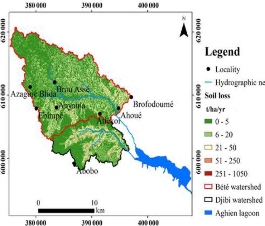
Figure 1. Study area (Ehouman et al., 2019).
Figure 2. Rainfall (a) and Discharge (b) relationship in Aghien lagoon watershed (Ehouman et al., 2019).
tributaries (Bété and Djibi) feed this lagoon. Among them, of coarse sands, variegated clays, and ferruginous sandstones
Djibi’s watershed is highly urbanized (Fig. 1). with iron ore. Since these formations are vulnerable to water
Aghien lagoon watershed is influenced by a humid tropi- erosion, Aghien lagoon watershed could be exposed to silt-
cal climate characterized by 4 seasons: a large rainy season ing from soil loss. For a better understanding of how this
(March–July) and a short rainy season (October–November). lagoon works, we set out to estimate the soil loss that would
The annual rainfall was 1553 mm in 2016 and 2198 mm contribute to its silting up due to water erosion from its main
in 2017. The other two periods correspond to more or less tributaries.
dry seasons. The hydrological regime is bimodal in close
relation with the rainfall regime. Heavy rainfall occurs in
June causing heavy floods, which define the potential wa- 2 Material and methods
ter erosion (Fig. 2). According to Soro et al. (2004), Aghien
lagoon watershed is located in a sedimentary environment The material consists of a soil map of the sedimentary wa-
formed mainly by tertiary and quaternary deposits made up tershed of Côte d’Ivoire at a scale of 1 : 200 000 from the
archive of Vennetier (1973), a digital elevation model (DTM)
Proc. IAHS, 384, 121–126, 2021 https://doi.org/10.5194/piahs-384-121-2021
A. Dao et al.: Soil loss vulnerability: the case study of Aghien lagoon watershed outskirts Abidjan city                       123

Figure 3. Hydroclimatic measurement network of Aghien lagoon watershed.

and Landsat 8 OLI images in resolution of 30 m for the             Table 1. Variation of m as a function of the slope (Payet et al.,
years 2016 and 2017. The rainfall data come from six rain-         2011).
fallstations installed in the watershed as part of Aghien la-
goon project (Fig. 3).                                                             Percentage of slope (%)   Factor m
   The method for estimating soil loss is based on USLE                            ≥5                          0.5
by taking account five key factors: the erosivity of rainfall,                     3.5 ≤ θ < 5                 0.4
the soil erodibility, the topographic factor integrating slope                     1 ≤ θ < 3.5                 0.3
length and steepness, the cover-management factor and the
124                         A. Dao et al.: Soil loss vulnerability: the case study of Aghien lagoon watershed outskirts Abidjan city

Table 2. Erosion values by vegetation cover in Côte d’Ivoire (Roose
and Lelong, 1976).

        Rainfall stations            Erosion (t ha−1 yr−1 )
        in Côte d’Ivoire            Natural      Bare    Culture
                               environment     ground
        Adiopodoumé
                                    0.03–1    60–570      0.1–90
        (forest)
        Bouaké
                                  0.01–0.2      18–30     0.1–26
        (dense savannah)
        Korhogo
                                    0.1–0.2       8–9         –
        (clear savannah)

                                                                        Figure 5. Soil loss in Aghien lagoon tributaries watershed (2016).

Figure 4. Methodology for estimating soil loss (Meliho et al.,
2016).

3     Results and discussion

3.1     Results

3.1.1     Estimation of Aghien lagoon tributaries’ watershed
          soil loss

Figures 5 and 6 are the results of thematic maps of the main
factors involved in soil loss. Indeed, these maps show the
tributaries’ watershed of Aghien lagoon (see Fig. 3). Soil              Figure 6. Soil loss in Aghien lagoon tributaries watershed (2017).
loss is varying essentially between 0 and 250 t ha−1 yr−1
in 2016. It can be seen that the low soil loss classes (0–
20 t ha−1 yr−1 ) are very widespread in the watershed. On the
contrary, the classes of high soil loss (50–1050 t ha−1 yr−1 )          nerability ranging from “very low” to “very high” (Tables 3
are not widespread and seems to follow the hydrographic net-            and 4). With regard to the two years (2016 and 2017), the
work. In 2017, this observed trend is clearly increasing for            dominant vulnerability of the lagoon in connection with wa-
high soil loss classes. The very high one goes from 250 to              ter erosion is “low” category. In fact, in 2016, the soil loss
1050 t ha−1 yr−1 .                                                      class ranging from 6 to 20 t ha−1 yr−1 occupies more than
                                                                        60 % of the area of the two sub-basins. This trend increased
3.1.2     Vulnerability of Aghien lagoon face to its
                                                                        in 2017 with soil loss area of 18 210 ha, equivalent of 71 %
          tributaries’ watershed soil loss
                                                                        of the two tributaries area.
                                                                           The “very low” vulnerability comes second with area
Vulnerability of the lagoon face to its tributaries’ watershed          percentages of 27 % and 24 % respectively in 2016
soil loss is estimated by the area percentages. Percentages             and 2017. The “very high” vulnerability ranging from 251 to
of soil loss area make it possible to assess the soil loss vul-         1050 t ha−1 yr−1 in 2016 occupied only 0.01 % of the area.

Proc. IAHS, 384, 121–126, 2021                                                          https://doi.org/10.5194/piahs-384-121-2021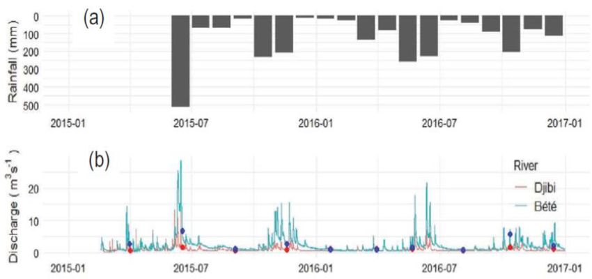
A. Dao et al.: Soil loss vulnerability: the case study of Aghien lagoon watershed outskirts Abidjan city                            125

Table 3. Vulnerability of Aghien lagoon to soil loss in 2016.       and culture (Roose and Lelong, 1976), are between the tol-
                                                                    erance threshold which is (1–12 t ha−1 yr−1 ) set by Kouadio
       Class of soil loss    Area     Area    Vulnerability         et al. (2007). The deposition of soil loss and substances in
       (t ha−1 yr−1 )        (ha)      (%)    of the lagoon         the lagoon could contribute in the long term to its pollution
       0–5                   7071    27.55    Very low              and siltation, thus causing a drastic reduction of surface wa-
       6–20                 15 552   60.59    low                   ter (Meliho et al., 2016; Zouagui et al., 2018).
       21–50                 2650    10.32    medium
       51–250                  393    1.53    high                  4   Conclusion
       251–1050                  3    0.01    Very high
                                                                    The aim of this paper was to study the soil loss vulnera-
                                                                    bility in Aghien lagoon watershed. The combination of the
Table 4. Vulnerability of Aghien lagoon to soil loss in 2017.
                                                                    factors of the universal soil loss equation made it possible
                                                                    to obtain soil loss maps of the lagoon tributaries’ watershed
       Class of soil loss    Area     Area    Vulnerability
                                                                    (Bété and Djibi). The results showed that soil loss varying
       (t ha−1 yr−1 )        (ha)      (%)    of the lagoon
                                                                    mostly between 0 and 250 t ha−1 yr−1 . With regard to the two
       0–5                   6228    24.27    Very low              years (2016 and 2017), the dominant vulnerability of the la-
       6–20                 18 210   70.95    low                   goon in connection face to water erosion is “low” category.
       21–50                   971    3.78    medium                In fact, the soil loss class ranging from 0 to 20 t ha−1 yr−1 oc-
       51–250                  244    0.95    high                  cupies more than 60 % of the two sub-basins area. This trend
       251–1050                 12    0.05    Very high
                                                                    increased in 2017 with soil loss of 71 %. The “very low”
                                                                    vulnerability comes second with area percentages of 27 %
                                                                    and 24 % respectively in 2016 and 2017. The “very high”
In 2017, this category of vulnerability increased in intensity,     vulnerability ranging from 250 to 1050 t ha−1 yr−1 in 2016
occupying 0.05 % of the sub-basins.                                 occupied only 0.01 % of the area. In 2017, this category of
                                                                    vulnerability increased in intensity, occupying 0.05 % of the
3.2   Discussion                                                    sub-basins. Ultimately, this dynamic of water erosion corre-
                                                                    lated with strong anthropogenic pollution could compromise
The soil loss maps show that the areas where soil losses vul-       the use of Aghien lagoon as a freshwater reserve for Abidjan
nerability are not dominant in the lagoon watershed (very           city. This work is a contribution to understand the function-
low-to-low category), are very widespread and cover large ar-       ing of Aghien lagoon. Applying the universal soil loss equa-
eas (88 % in 2016 and 95 % in 2017). These percentages are          tion over a long series of rainfall and land use data could
corresponding respectively to soil loss of 0 to 20 t ha−1 yr−1      improve the results of this work.
during the two years. These values can be classified in the
same category as those obtained by Roose and Lelong (1976)
in the same climatic zone in Côte d’Ivoire (see Table 2, the        Code availability. The GIS software used is Quantum GIS. The
case of Adiopodoumé). They can be explained by the pres-            code is publicly accessible at https://www.qgis.org/fr/site/forusers/
ence of abundant vegetation and gentle slopes (Roose et al.,        download.html (QGIS, 2021).
2014). However, highly vulnerable areas occupy an infinite
part with soil loss going to 251 to 1050 t ha−1 yr−1 covering
respectively area percentages of 0.01 % and 0.05 % respec-          Data availability. Data is available via the link: https://dataverse.
tively in 2016 and 2017. These high values of soil loss and         ird.fr/dataverse/root?q=Aghien (Dataverse, 2021).
low percentages of area can be due to the topographic fac-
tor integrating slope length along the hydrographic network
(Payet et al., 2011). Overall, the increase in the risk of ero-     Author contributions. AD rote the manuscript with the data col-
                                                                    lected and compilated under quantum GIS software by ESK. DDN,
sion between 2016 and 2017 in the watershed could be ex-
                                                                    BK and LDG read and correct the document. LS and JLP are our re-
plained by rampant urbanization (see Fig. 1) and overgrazing
                                                                    search partners within the framework of the Aghien lagoon project.
leading to the destruction of the vegetation in progress (Aké
et al., 2012). In addition, this degradation exposes the water-
shed to very strong runoff and very little infiltration (El hafid   Competing interests. The contact author has declared that nei-
et Akdim, 2018). Soil displaced by erosion carries nutri-           ther they nor their co-authors have any competing interests.
ents, pesticides and other chemicals (Benkaci et al., 2018).
In the case of Aghien lagoon watershed, most of these harm-
ful products can be carried by the two rivers to the lagoon         Disclaimer. Publisher’s note: Copernicus Publications remains
(Ehouman et al., 2019). The assessment of soil loss gave high       neutral with regard to jurisdictional claims in published maps and
soil loss from 50–250, these values assigned to bare ground         institutional affiliations.

https://doi.org/10.5194/piahs-384-121-2021                                                        Proc. IAHS, 384, 121–126, 2021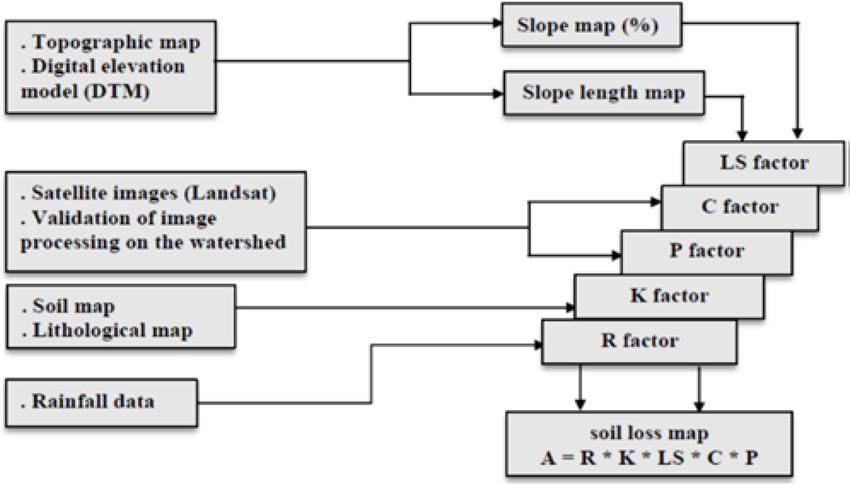
126                    A. Dao et al.: Soil loss vulnerability: the case study of Aghien lagoon watershed outskirts Abidjan city

Special issue statement. This article is part of the special issue      Kouadio, B. H., Kouamé, K. F., Saley, M., Biemi, J., and Traoré,
“Hydrology of Large River Basins of Africa”. It is a result of the         I.: Insécurité climatique et géorisques en Côte d’Ivoire: étude du
4th International Conference on the “Hydrology of the Great Rivers         risque d’érosion hydrique des sols dans la région semimontag-
of Africa”, Cotonou, Benin, 13–20 November 2021.                           neuse de Man (Ouest de la Côte d’Ivoire), Sécheresse, 18, 29–37,
                                                                           2007.
                                                                        Meliho, M., Khattabi, A., Mhammdi, N., and Zhang, H.: Cartogra-
Acknowledgements. Our thanks go to the “Debt Reduction and                 phie Des Risques De L’erosion Hydrique Par L’equation Uni-
Development Contract” (C2D) between France and Côte d’Ivoire               verselle Revisee Des Pertes En Sols, La Teledetection Et Les Sig
which funded the research activities of “Aghien lagoon” project            Dans Le Bassin Versant De L’ourika (Haut Atlas, Maroc), Eur.
through the partnership PReSeD-CI. This partnership was a very             Scient. J., 12, 32, https://doi.org/10.19044/esj.2016.v12n32p277,
good collaboration between researchers from Université Nangui              2016.
Abrogoua (UNA), in particular those from the “Laboratoire de Géo-       N’Dri, B. E., N’Go, Y. A., Kadio, H. N., Ouattara, A., Touré, B., and
sciences et Environnement” (LGE) and researchers from the French           Biémi, J.: Effect of soil slope and cover on runoff and rate soil
Institute for Research and Development (IRD).                              loss from experimental plots in area of Attécoubé, Eur. J. Scient.
                                                                           Res., 21, 459–470, 2008.
                                                                        Payet, E., Dumas, P., and Pennober, G.: Modélisation de
Financial support. This research has been supported by the Con-            l’érosion hydrique des sols sur un bassin versant du
trat Desendettement Developpement (C2D) (Lot no. 4 du projet               sud-ouest de Madagascar, le Fiherenana, Vertigo, 11, 3,
AMRUGE-CI – Appui à la Modernisation et à la Réforme des Uni-              https://doi.org/10.4000/vertigo.12591, 2011.
versités et Grandes Ecoles de Côte d’Ivoire).                           QGIS: Un logiciel open source utilisant la licence GNU Gen-
                                                                           eral Public License ce qui signifie que son code source peut
                                                                           être téléchargé via des archives tar ou un dépôt git at: https://
                                                                           www.qgis.org/fr/site/forusers/download.html, last access: 20 Oc-
References                                                                 tober 2021.
                                                                        Roose, E., Sabir, M., and Laouina, A.: Gestion durable des eaux et
Aké, G. E., Kouadio, B. H., Adja, M. G., Ettien, J. B., Ef-                des sols au Maroc, OpenEdition Books, IRD Éditions, p. 343,
  febi K. R., and Biémi, J.: Cartographie de la vulnérabilité              https://doi.org/10.4000/books.irdeditions.294, 2014.
  multifactorielle à l’érosion hydrique des sols de la région de        Roose, E. J. and Lelong, F.: Les facteurs de l’érosion hydrique en
  Bonoua (Sud-Est de la Côte d’Ivoire), Physio. Geo., 6, 1–42,             Afrique tropical, in: Etudes sur petites parcelles expérimentales
  https://doi.org/10.4000/physio-geo.2285, 2012.                           de sol, 21, vol. xviii, fasc. 4, Revue de géographie physique et de
Benkaci, S., Abir, D., Oumellal, A., and Boualem, R. B.: Modélisa-         géologie Dynamique, 18, 365–374, 1976.
  tion de l’érosion du bassin haut et moyen Cheliff par l’application   Soro, N.; Lasm, T., Kouadio, B. H., Soro, G., and Ahoussi, K. E.:
  Model builder sur ArcGis, J. Mater. Eng. Struct., 5, 81–93, 2018.        Variabilité du régime pluviométrique du Sud de la Côte d’Ivoire
Chadli, K.: Estimation of soil loss using RUSLE model for Se-              et son impact sur alimentation de la nappe d’Abidjan, Sud Sci.
  bou watershed (Morocco), Model. Earth Syst. Environ., 2, 2–10,           Technol., 14, 30–40, 2004.
  https://doi.org/10.1007/s40808-016-0105-y, 2016.                      Stone, R. P. and Hilborn, D,: Universal Soil Loss Equation (USLE),
Dataverse: Des données ouvertes pour une science durable                   Agdex#: 572/751, 2012.
  au Sud, available at: https://dataverse.ird.fr/dataverse/root?q=      Vennetier, P.: Le milieu naturel de la Côte d’Ivoire, Les Cahiers
  Aghien, last access: 19 October 2021.                                    d’Outre-Mer Année 1973 26-104, Les Cahiers d’Outre-Mer,
Eblin, S. G., Yao, A. B., Anoh, K. A., and Soro, N.: Cartographie de       p. 440, 1973.
  la vulnérabilité multifactorielle aux risques d’érosion hydrique      Wischmeier, V. H. and Smith, D. D.: Predicting rainfall erosion
  des sols de la région d’Adiaké, Sud-Est côtier de la Côte d’Ivoire,      losses- a guide to conservation planning, Agriculture Handbook
  Rev. Ivoir. Sci. Technol., 30, 197–216, 2017.                            No. 282, United States Department of Agriculture in cooperation
Ehouman, K. S., Koffi, K. T., Perrin, J. L., Séguis, L., Guil-             with Purdue Agricultural Experiment Station, Washington, 1978.
  liod, M., Droh, L. G., and Kamagaté, B.: Hydrological and             Zouagui, A., Sabir, M., Naimi, M., and Benmansour, M.: Modéli-
  water quality assessment of the Aghien Lagoon hydrosystem                sation du risque d’érosion hydrique par l’équation universelle
  (Abidjan, Côte d’Ivoire), Hydrolog. Sci. J., 64, 1893–1908,              des pertes en terre dans le rif occidental: cas du bassin ver-
  https://doi.org/10.1080/02626667.2019.1672875, 2019.                     sant de Moulay Bouchta (Maroc), Eur. Scient. J., 14, 524–544,
El hafid, D. and Akdim., B.: Quantification De L’érosion Hy-               https://doi.org/10.19044/esj.2018.v14n3p524, 2018.
  drique En Utilisant Le Modèle Rusle Et Déposition In-
  tégrée Dans Un Sig, Cas Du Bassin Versant De L’oued
  Isly (Maroc Oriental), Eur. Scient. J., 14, 1857–7881,
  https://doi.org/10.19044/esj.2018.v14n5p373, 2018.

Proc. IAHS, 384, 121–126, 2021                                                           https://doi.org/10.5194/piahs-384-121-2021
You can also read