Stillaguamish Tribe of Indians Natural Resources Department Wetlands Program Plan 2019-2024 - February 2019
←
→
Page content transcription
If your browser does not render page correctly, please read the page content below
Stillaguamish Tribe of Indians
Natural Resources Department
     Wetlands Program Plan
          2019-2024

          February 2019

               Prepared by
     Charlotte Scofield and Jody Pope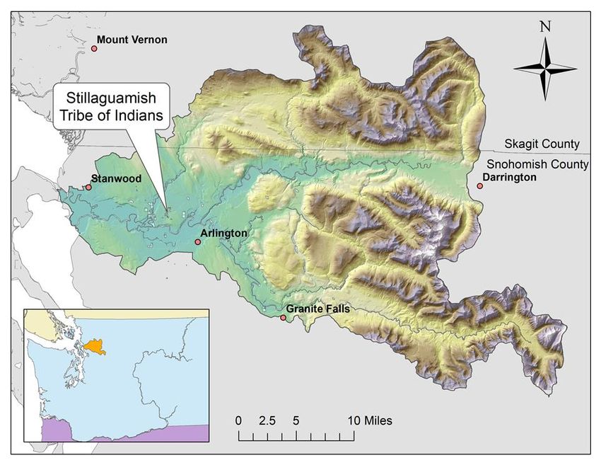
Table of Contents
Purpose ............................................................................................................................... 3
Overall Goal Statement and Timeframe for Plan ............................................................... 4
Overview of the Stillaguamish Watershed and Wetlands .................................................. 5
Core Element Actions and Activities ................................................................................... 7
Monitoring and Assessment ............................................................................................... 7
   Current Status of Monitoring and Assessment............................................................... 7
Voluntary Restoration and Protection ................................................................................ 8
   Current Status of Voluntary Restoration and Protection ............................................... 8
Program Evaluation............................................................................................................. 9
Approximate Timeline of Wetland Program Activities (2019-2024) ................................ 10
Potential Partnerships ...................................................................................................... 12
       Within the Tribe ........................................................................................................ 12
       Outside Organizations............................................................................................... 12
Potential Funding Sources ................................................................................................ 13
Responsible Parties for Plan Implementation .................................................................. 14
References ........................................................................................................................ 15
Appendix A Approved Tribal Resolution ........................................................................... 16
Appendix: I approved tribal resolution ............................................................................. 16

                                                                   2
Purpose
The purpose of the Stillaguamish Tribe of Indians - Natural Resources Department,
Wetlands Program is to monitor and assess baseline condition and function of wetland
resources and using that information to inform departmental decision-making. This will
allow the department to identify and prioritize the restoration and protection of
wetlands on Tribally owned land and within the Stillaguamish watershed. These goals fit
into the Department’s overall mission of protecting Tribal Treaty Rights as described
below.
The Stillaguamish Tribe of Indians Natural Resources Department Mission Statement:
The Stillaguamish Tribe of Indians Natural Resources Department came into being as a
result of U.S. v. Washington, Civil 9213, and better known as the Boldt Decision of 1974.
In this case, which was affirmed by the U.S. Supreme Court, Puget Sound Indian Tribes
who signed treaties with Isaac Stevens in the late 1800's retained the right to take up to
50% of all harvestable (beyond what is required to ensure reproductive success) fish and
shellfish resources within their respective Usual and Accustomed (U&A's) areas. Because
the welfare of Treaty Tribes is the responsibility of the U.S. Government (Trust status), it
became the responsibility of the Bureau of Indian Affairs (BIA) to manage fish, shellfish,
and other natural resources for the benefit of the Tribes. Seeing the benefit of having
each Tribe manage its own resources, the BIA entered into contracts with the Tribes for
the purpose of providing management of fish and shellfish resources within their
respective U&A's.
The mission of the Natural Resources Department is therefore to manage, protect, and
conserve those natural resources that are required to sustain healthy populations of
fish, shellfish, and wildlife within the Stillaguamish Tribe's traditional homelands. The
Tribe's contract with the BIA provides for enrollment of Tribal members for certifying an
individual's right to take fish, shellfish, and wildlife for commercial as well as ceremonial
purposes.
"The river is alive. It is an essential part of our lives. When it is vibrant and healthy, our
well-being is preserved. We must heal and protect this precious resource, not just for our
own Tribal Treaty rights, but because it's a wise and respectful thing to do for everyone
who lives here."
-Lew Goodridge
Tribal Elder
3Overall Goal Statement and Timeframe for Plan
The Stillaguamish Tribe of Indians Natural Resources Department (NRD) received
wetland program development funds (WPDG) from the Environmental Protection
Agency (EPA) to develop and begin to carry out the objectives described in the wetland
program plan (WPP) from 2015 through 2018. During this timeframe, a monitoring and
assessment strategy document (MAS) and quality and assurance program plan (QAPP)
were developed and approved by the EPA. The methods were tested and initial baseline
monitoring and data collection was completed. Landscape scale assessments using
Geographic Information Systems (GIS) of wetlands within the Stillaguamish watershed
was also completed.
The objectives of this plan for the next six years (2019-2024) will be, in the short-term a
continuation of monitoring and assessment work and baseline data collection, focused
on Tribally owned lands, but other wetland areas within the Stillaguamish watershed
will be monitored as well. The data collected through this effort will be used to inform
natural resources management and future decision making for Tribal government. In
the long-term, the wetland program will use the data collected to design restoration
projects. For example, vegetation data can inform what types of plant species need to
either be removed or enhanced. Also, data collected can prioritize wetlands for
restoration and future acquisition for protection and conservation of these valued
resources.
The wetland program will complement the Tribe’s other environmental programs to
work toward protection and restoration of wetland resources within the Stillaguamish
Tribe’s traditional homeland areas.
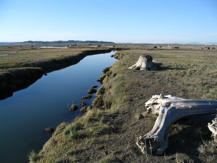
4Overview of the Stillaguamish Watershed and Wetlands
The Stillaguamish watershed (Water Resources Inventory Area (WRIA) 5) drains an area
of approximately 700 square miles and includes more than 3,112 miles of river, stream,
and marine shore habitat (Figure 1). The Stillaguamish River is the fifth largest tributary
to Puget Sound. Elevations in the watershed range from sea level to about 6,854 feet on
Three Fingers Mountain. The river enters Puget Sound at Stanwood, 16 miles north of
Everett in northwestern Snohomish County. The watershed drains into both Port Susan
and Skagit Bay. It is also part of the Whidbey Basin, which includes Skagit Bay, Saratoga
Passage, Port Susan, and Deception Pass.
Figure 1 Location of Stillaguamish Watershed
The Stillaguamish watershed can be divided into three general regions: the North Fork,
South Fork, and Lower Mainstem. The two forks join in Arlington, 18 river miles from the
mouth. Pilchuck, Deer, Boulder, and Canyon Creeks are the four largest tributaries to the
Stillaguamish River system. The watershed includes land governed by Snohomish County
and Skagit County, the cities of Arlington, Stanwood, and Granite Falls, and the
5Stillaguamish and Tulalip Tribes (Figure 1). Federal, state, and private forest land uses
occupy the majority of the watershed.
The local climate is typically maritime with cool, wet winters and mild summers. Rainfall
is highly variable throughout the watershed, with average annual rainfall ranging from 30
inches per year in the western lowlands of the watershed to 150 inches per year at higher
elevations in the eastern portion of the watershed. Approximately 75% of the
precipitation falls between October and March.
Currently, the Tribe has approximately 64 acres of reservation land, an additional 592
acres of property in Tribal trust and 1214 acres of Tribally owned lands dispersed
throughout the Stillaguamish watershed.
Wetlands within the Stillaguamish watershed help maintain and improve the water
quality of streams, rivers, lakes, and estuaries. In addition, wetlands perform functions
such as providing wildlife habitat, flood reduction, and erosion control. For a variety of
wildlife species, including invertebrates, fish, amphibians, reptiles, birds, and mammals,
wetlands are essential habitats for foraging, nesting, cover, or breeding.
Of the historic 1,350,000 acres of wetlands in Washington State approximately 412,000
(31%) acres had been lost as of the early 1990s and the majority of Washington State's
remaining wetlands have been significantly degraded (Washington State Department of
Ecology 1992). The principal historical causes of wetland loss and degradation are
draining and ditching for the expansion of agriculture and the siting of ports and
industrial facilities. The major causes of continuing loss and degradation of wetlands are
urban expansion, forestry/agricultural practices, and the invasion of exotic plants and
animals (Canning and Stevens 1989).
Similarly to Washington State, relative to historical conditions, wetlands in the
Stillaguamish watershed have been extensively lost or degraded (Pollack and Pess 1998,
Washington State Department of Ecology 1992). The Stillaguamish watershed
historically supported 29,133 acres of wetlands, while the current total wetland area is
estimated to be 6,266 acres, approximately 78% loss of historic wetlands (Washington
State Conservation Commission 1999).
Finally, wetlands resources are significant to the Tribe’s culture and for maintaining and
practicing their Treaty Rights. In order to be successful in protecting and restoring these
Tribally valuable resources into the future the Tribe needs a plan to guide management
decisions and funding sources to do so.
6Core Element Actions and Activities
The following goals, objectives and activities outline the priority needs for the
Stillaguamish wetland program over the next six years. The actions identified below will
be used as guidance and are subject to revision depending on Tribal needs and available
funding.
Monitoring and Assessment
Goal: Inventory, monitor and assess wetland resources, located on Tribal property and
throughout the Stillaguamish watershed, in an affordable and efficient manner.
Objectives: Implement monitoring and assessment strategy and use data collected to
inform departmental decision-making.
Activity:
- Monitor Tribal properties list (provided by the Tribe’s planning department) for
newly acquired properties to determine if wetland resources are present and
incorporate into departmental GIS wetland map.
- Pursue funding opportunities for wetland monitoring and assessment activities
(e.g. WPDG).
- Incorporate monitoring data into departmental decision-making. For example,
when discussing restoration opportunities on Tribal land, monitoring data
(wetland class, vegetation types, water quality, etc.) can be used to inform what
might be needed at a specific site and overall restoration objectives can be
developed. Also, when the Tribe is looking to develop a property, monitoring
data can be provided to the decision making team so they have all the technical
information available to inform their decision and how to manage for wetland
resources on Tribal property.
- Train staff by attending applicable wetlands trainings and conferences, such as
the Tribal Wetlands Working Group (TWIG) meetings, Association of State
Wetland Managers webinars and Society of Wetland Scientist or Ecological
Restoration Conferences should they coincide with grant timeline.
Current Status of Monitoring and Assessment
Modelled after the EPA 3-level wetland assessment strategy, the Stillaguamish Tribe,
using level 1 GIS landscape scale remote-sensing data, developed a series of maps of
wetland resources located within the Stillaguamish watershed; using the Washington
Department of Ecology Wetland rating system, the Tribe conducted level 2 rapid
assessment for qualitatively scoring wetlands; and developed a level 3, intensive
wetland monitoring and assessment strategy document and corresponding QAPP. The
level 3 monitoring and assessment strategy methods were tested during a pilot survey
effort to determine efficiency and effectiveness. These methods include, vegetation,
7soil and water quality sampling (Stillaguamish Tribe Wetland Monitoring and
Assessment Strategy, 2018). Slight modifications to the strategy document were made
based upon the implementation of the pilot survey. The revised strategy document and
QAPP were approved by the EPA in 2018. The Tribe received another round of Tribal
WPDG funds to continue to carry out wetland monitoring and assessment activities
through October 2019.
Voluntary Restoration and Protection
Goal: Identify and prioritize wetlands to restore, conserve, and protect on Tribal
properties and throughout the Stillaguamish watershed.
Objectives: Develop and improve Tribal wetland restoration and protection goals. Use
monitoring data and GIS maps and model to identify priority wetland sites for
preservation and restoration and identify sites for future acquisition, enhance native
vegetation species diversity on wetlands, communicate and collaborate with other
Tribal departments to achieve wetland resource restoration and protection goals.
Activity:
- Use monitoring and assessment data, from the up to 6 wetland sites surveyed, to
identify and prioritize wetland resources on Tribally-owned lands and
throughout the Stillaguamish watershed for restoration, protection and future
land acquisitions. A site assessment document will be produced describing
wetland resources on the site and how to restore the resources.
- Collaborate with NRD programs and Tribal departments to incorporate wetlands
values into educational curriculum and decision-making. For example, when the
Tribe is scoping property development and acquisition opportunities, if the site
has been monitored for wetland resources, we can provide valuable information
to the necessary decision makers on what types of wetland resources are
present on the property. Additionally, site assessment and monitoring provide
information that can be shared with the department’s education and outreach
program for use in their educational programs to Tribal youth and area schools.
Current Status of Voluntary Restoration and Protection
The previous WPDG grant objectives were to develop GIS based maps, a wetland
monitoring and assessment strategy document and to collect data; therefore, there was
no capacity to carry out the objectives of the voluntary restoration and protection core
element.
8Program Evaluation
The Wetlands program plan should be evaluated midway (in roughly three years) to
ensure the plan is on track for achieving identified actions and activities. Evaluation
should receive feedback from departmental programs and the EPA to assess program
effectiveness.
9Approximate Timeline of Wetland Program Activities (2019-2024)
10CORE ELEMENTS
2019 2020 2021 2022 2023 2024
MONITORING AND ASSESSMENT
Objectives: Implement monitoring and assessment strategy and use data collected to inform departmental decision-making.
Monitor Tribal properties list for newly
x x x x x x
acquired properties to determine if wetland
resources are present and incorporate into
departmental GIS wetland map.
Pursue funding opportunities for wetland
monitoring and assessment activities e.g. x x x x x x
WPDG.
Monitor and assess wetlands, up to 6 sites per
year, on Tribal property and throughout the x x x x x x
Stillaguamish watershed.
Incorporate monitoring data into departmental x x x x x x
decision-making.
Train staff by attending applicable wetlands x x x x x x
trainings and conferences.
VOLUNTARY RESTORATION AND PROTECTION
Objectives: Develop and improve Tribal wetland restoration and protection goals, identify priority wetland sites for preservation and restoration and
identify sites for future acquisition, enhance native vegetation species diversity on wetlands, communicate and collaborate with other Tribal departments
to achieve wetland resource restoration and protection goals.
Use monitoring and assessment data, from the
up to 6 wetland sites surveyed, to identify and x x x x x x
prioritize wetland resources on Tribally-owned
lands and throughout the Stillaguamish
watershed for restoration, protection and
future land acquisitions. Produce a site-
assessment document describing wetland
resources on the site and how the resources
can be restored.
Collaborate with NRD programs and Tribal
departments to incorporate wetlands values x x x x x
into educational curriculum and decision-
making.
11Potential Partnerships
Within the Tribe
Planning Department- provide Tribal property
data
Cultural Department- provide list of culturally
significant plants and share with them data
collected on wetlands
Education Department – collaborate for
wetland education for Tribal youth
Outside Organizations
Bureau of Indian Affairs (BIA)- funding and
inter-Tribal wetland forum (IWF)
Citizen science groups- volunteer labor
Washington State Department of Ecology
(DOE)- data source and funding
Environmental Protection Agency (EPA)-
provide methods, protocols, and funding
NOAA Fisheries-data source and funding
Point Elliot Treaty Tribes- information
sharing, funding sources, project ideas, staff
assistance
Snohomish County- data source
Skagit Valley Community College- student
interns
U.S. Fish and Wildlife Service- data source
and funding
United States Geological Survey (USGS)- WQ
data source
University of Washington (UW)- provide
climate change data
Washington Department Fish and Wildlife
(WDFW)- data source
Washington Department of Natural
Resources (DNR)- data source
Western Washington University (WWU)-data
source, student intern
12Potential Funding Sources
Environmental Protection Agency (EPA)
Seattle City Light (SCL)
Puget Sound Energy (PSE)
Washington Department of Transportation (WSDOT)
Natural Resources Conservation Service (NRCS)
United States Fish and Wildlife Service (USFWS)
Washington State Department of Ecology (WA DOE)
Bureau of Indians Affairs (BIA)
National Oceanic Atmospheric Association (NOAA)
13Responsible Parties for Plan Implementation
The personnel from the Stillaguamish Tribe of Indians who will be responsible for the
Wetland Program Plan implementation are presented below.
Project Personnel Title Responsibility
Oversees all activities associated with the
Project Biologist,
Jen Sevigny Wetland Program Plan
Stillaguamish Tribe NRD
jsevigny@stillaguamish.com
Responsible for field activities associated
Lead Project Biologist, with implementation of Wetland
Charlotte Scofield
Stillaguamish Tribe NRD Program Plan
cscofield@stillaguamish.com
Fish and Wildlife Assists biologists with field data
Rick Rogers Technician collection and GIS analysis.
Stillaguamish Tribe NRD rrogers@stillaguamish.com
Fish and Wildlife Assists biologists with field data
Amanda Summers Technician collection and GIS analysis.
Stillaguamish Tribe NRD asummers@stillaguamish.com
Certified Accountant, Responsible for fund accounting
Virginia Elves, CPA
Stillaguamish Tribe velves@stillaguamish.com
Oversees and approves all programs and
projects associated with the natural
Department Director,
Gina Gray resources department and employees
Stillaguamish Tribe NRD
ggray@stillaguamish.com
Provides oversight of grant tasks and
EPA Region 10 Grant
Westley Foster progress
Manager
Foster.Westley@epa.gov
Provides technical assistance and
EPA Region 10 Technical
Linda Storm oversight of grant tasks and progress
Monitor
Storm.Linda@epa.gov
14References
Canning, D.J., and M. Stevens. (1989). Wetlands of Washington - A resource
characterization. Washington State Department of Ecology, Olympia, WA.
Pollock, M. M., G. R. Pess. (1998). The current and historical influence of beaver (Castor
canadensis) on Coho (Oncorhynchus kisutch) smolt production in the Stillaguamish
River basin. Stillaguamish Tribe of Indians Natural Resources Department, Arlington,
WA.
Stillaguamish Tribe of Indians. (2018). Wetland Monitoring and Assessment Strategy,
Determining methods to asses wetland condition and function. Stillaguamish Tribe
of Indians Natural Resources Department, Arlington, WA.
Washington State Conservation Commission. (1999). Salmon Habitat Limiting Factors
Final Report – Water Resource Inventory Area 5, Stillaguamish Watershed. Retrieved
March 15, 2018 from:
http://www.co.snohomish.wa.us/documents/Departments/Public_Works/SWM/S-
SalmonHabLimitFactorsStilly-Jul1999.pdf
Washington State Department of Ecology. (1992). Focus--Wetlands in Washington State.
F-S-92-108 Washington State Department of Ecology, Olympia, WA.
15Appendix A Approved Tribal Resolution
16You can also read