South African Coal Desktop Study - XMP Consulting
←
→
Page content transcription
If your browser does not render page correctly, please read the page content below
South African Coal Desktop Study
INDEX

INTRODUCTION......................................................................2                      4. New Denmark Colliery................................................... 20
                                                                                                      WATERBERG COALFIELD................................................. 20
THE SOUTH AFRICAN COALFIELDS....................3
                                                                                                         Grootegeluk Colliery........................................................... 20
   1. Witbank..................................................................................4
                                                                                                      VEREENEGING-SASOLBURG COALFIELD............... 21
   2. Highveld.................................................................................4
                                                                                                         New Vaal Colliery.................................................................. 21
   3. Waterberg..............................................................................5
   4. Vereeniging-Sasolburg.....................................................5
                                                                                                      ERMELO COALFIELD........................................................... 21
                                                                                                         Savmore Colliery................................................................... 21
   5. Ermelo.....................................................................................6
   6. Klipriver..................................................................................7    KLIPRIVIER COALFIELD..................................................... 22
   7. Vryheid....................................................................................7       1. Slater Coal (Forbes Coal)............................................... 22
   8. Utrecht....................................................................................8       2. Springlake Colliery.......................................................... 22
   9. Nongoma...............................................................................8         NONGOMA COALFIELD.................................................... 23
   10. Somkele...............................................................................9           Zululand Anthracite Colliery............................................ 23
   11. Soutpansberg....................................................................9              SOMKELE COALFIELD........................................................ 23
   12. Kangwane...........................................................................9              Somkhele Colliery................................................................ 23
   13. Thuli.................................................................................... 10   VRYHEID COALFIELD......................................................... 24
                                                                                                         Vaalkrantz Colliery............................................................... 24
THE SOUTH AFRICAN COAL MINES................. 11
                                                                                                      SOUTPANSBERG COALFIELD........................................ 24
WITBANK COALFIELD........................................................ 11
                                                                                                         Tshikondeni Coal Mine....................................................... 25
   1. Douglas-Middelburg Operations............................... 11
                                                                                                      KANGWANE COALFIELD.................................................. 25
   2. Khutala Colliery................................................................ 12
                                                                                                         Nkomati Anthracite............................................................. 25
   3. Matla Coal........................................................................... 12
                                                                                                      THULI COALFIELD................................................................ 25
   4. Optimum Colliery............................................................ 12
                                                                                                         Vele Coal.................................................................................. 25
   5. Shanduka Resources...................................................... 13
   6. Goedehoop Colliery ....................................................... 13                   APPENDIX I.............................................................................. 27
   7. Zibulo Colliery................................................................... 13           APPENDIX II............................................................................. 28
   8. Arnot Colliery.................................................................... 14           APPENDIX III........................................................................... 29
   9. Arthur Taylor/ ATCOM.................................................... 14                     APPENDIX IV........................................................................... 31
   10. Tweefontein Collieries................................................. 14
                                                                                                      APPENDIX V............................................................................. 32
   11. Middelkraal Colliery..................................................... 15
                                                                                                      APPENDIX VI........................................................................... 33
   12. Mafube Colliery.............................................................. 15
   13. Kleinkopje Colliery........................................................ 15
   14. Goedgevoden Colliery................................................ 16
   15. Landau Colliery.............................................................. 16
   16. Greenside Colliery......................................................... 16
   17. Klipspruit Colliery.......................................................... 17
   18. Glisa (North Block Complex)..................................... 17
   19. Vulna Colliery (Zonnebloem).................................... 17
   20. Leeuwpan Colliery........................................................ 18
HIGHVELD COALFIELD..................................................... 18
   1. Sasol Secunda................................................................... 18
   2. Kriel Colliery....................................................................... 19
   3. Isibonelo Colliery............................................................. 20

                                                                                                                                                                                                pg 1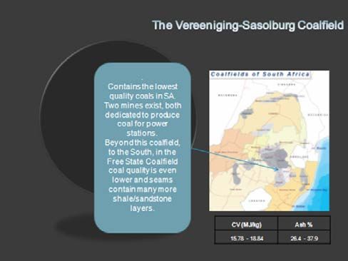
INTRODUCTION

XMP Consulting (XMP) has been requested to compile a desktop study on the Coal industry in South Africa.
The report includes the following:

Study of each of the 11 producing Coalfields
ERMELO, HIGHVELD, KANGWANE, KLIPRIVIER, NONGOMA, SOUTPANSBERG, UTRECHT, V-SASOLBURG, VRYHEID, WATERBERG
and WITBANK
     •   Coal resources/reserves and ROM/Saleable production for each Coalfield;
     •   Geology of the Karoo System of each Coalfield;
     •   List of collieries for each Coalfield.

Details of coal mines; major and junior with >3Mtpa in each Coalfield
     •   Name of Colliery and Holding Company;
     •   Detailed location (coordinates) and farms comprising each coal mine;
     •   Main shareholders of each coal mine;
     •   Status of each coal mine (in production/ greenfield or exploration stage);
     •   Mining method (opencast/underground), average stripping ratio for opencast mines;
     •   Resources/reserves/ROM/Saleable annual production tonnage of each mine;
     •   Coal type (Steam/PSS/ PCI/ Anthracite etc.) produced by each coal mine;
     •   Standard/expected coal quality (proximate analysis/ultimate analysis/ash fusion temperature/ash analysis/trace
          elements etc.);
     •    Cost analysis (mining costs/ transportation costs and port charges etc.);
     •    Status of permit or right under the PRMDA.

Transportation details for each coal mine
     •   Shipping port for export mines (RBCT, Durban, Maputo, etc);
     •   Distance from mine to shipping port;
     •   Status of rail contract (already secured or not), if secured, tonnage per year;
     •   Export allocation and capacity in Mtpa from RBCT/ Durban/Maputo/etc.;
     •   Export and domestic supply tonnage;
     •   Principal buyer (domestic market) and saleable tons to them per year.

                                                                                                                           pg 2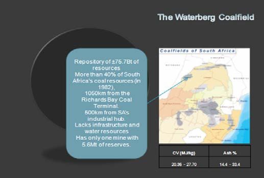
THE SOUTH AFRICAN COALFIELDS
Fig. 1 Coalfield Ranking by ROM production (2009)
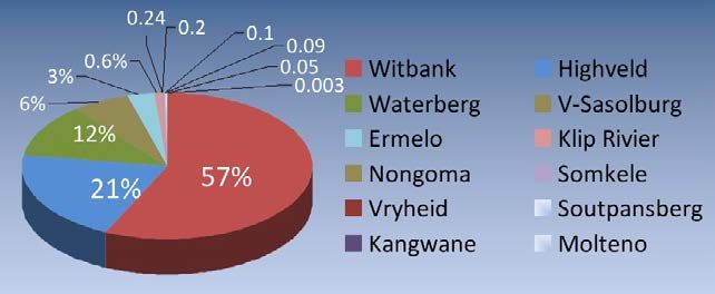
COAL RESERVES 2009
COALFIELDS RESERVES 2009 (Mt) %
HIGHVELD 9 474.6 29.2
WITBANK 8 509.3 26.2
WATERBERG 6 114.0 18.8
ERMELO 4 387.5 13.5
V-SASOLBURG 1 708.4 5.3
SOUTH RAND 715.5 2.2
UTRECHT 540.7 1.7
KLIPRIVIER 528.8 1.6
SOUTPANSBERG 257.4 0.8
KANGWANE 145.9 0.4
VRYHEID 99.6 0.3
NONGOMA 5.8 0.02
TOTAL 32 487.5 100
pg 3
1. Witbank

                                                              The Witbank Coalfield extends from Brakpan in the west through
                                                              to Belfast in the east. The northern boundary is a very irregular
                                                              sub-crop against the pre-Karoo basement rocks of predominantly
                                                              Waterberg sandstones with the most northerly limit about 15km
                                                              NW of Witbank, with many “inlets” to the east and west. The south
                                                              boundary is a prominent pre-Karoo felsite contact called the
                                                              Smithfield ridge. This basin was first exploited in the late 1800s
                                                              in the Brakpan (Apex Mines) region and has been the focus of
                                                              concerted exploration and exploitation ever since.
                                                        The basin is a multiple seam deposit type with the development
                                                        of five major seam horizons which may in places be composite
                                                        seams. The major controls for the development of the coal are
                                                        proximity to undulations of the “basement” topography, through
                                                        erosion channelling and sediment influx into swamp beds
                                                        and finally erosion of the current erosion surface. The primary
economic coal seams have been the No. 2 Seam and No. 4 Lower Seam and, in places, the No. 5 Seam.
Structurally, the coal horizons are un-deformed with each displaying a very slight dip to the south east of less than a degree
and minor discrete faulting events that have a south west to north east trend of graben features and other minor faulting
events. The most distinctive post-depositional feature is the intrusion of dolerites related to the Lesotho Basalts that have
resulted in a variety of sills and dykes of various ages. The most prominent of the dykes is the Ogies dyke, a 12 to 20m thick
essentially vertical intrusion with an east-west strike. The No. 4 Dolerite sill, a 20 to 70m thick multiple flow event, has a
preferential intrusion horizon above the No. 5 coal Seam, but in places it transgresses through the coal bearing strata to the
pre-Karoo basement and forms in other places a barrier to erosion.

2. Highveld

                                                                 The Highveld Coalfield is located in south eastern Mpumalanga
                                                                 Province, immediately south of the Witbank Coalfield. The
                                                                 width of the Coalfield is some 95km, stretching from Nigel in
                                                                 the west to Davel in the east, and is, in a N-S direction, about
                                                                 90km long, from just north of Kriel to beyond Standerton in
                                                                 the south and covers an area of approximately 7 000km2. After
                                                                 the Witbank Coalfield, the Highveld Coalfield is the next largest
                                                                 producing Coalfield in South Africa.
                                                              The Coalfield is host to up to five coal seams within the middle
                                                              Ecca Group sediments of the Karoo Supergroup. The Karoo
                                                              Supergroup comprises sediments ascribed to deposition in
                                                              glacial to fluvio-glacial and from shallow marine to fluvio-
                                                              deltaic environments. The Karoo Supergroup comprises the
                                                              following Groups (in decreasing age), although not all Groups
                                                              are completely represented in the Highveld Coalfield to the
present day erosion surface: Dwyka, Ecca, Beaufort, Stormberg and Drakensberg.
The five identified coal Seams contained in the Vryheid Formation (middle Ecca Group) are named, from the base up, as
follows: No.1 Seam; No.2 Seam; No.3 Seam; No.4 Seam and No.5 Seam.
In certain areas of the Coalfield, both the No.4 and No.2 Seams are split by clastic partings into the No.4 upper and No.4 lower
units. The Coalfield is characterized by the fact that in the northern regions, all the coal seams, with the exception of the No.3
Seam, attain mineable thicknesses with economic potential, while in the southern regions, only the No.4 Seam, and in very
localised areas, the No.2 and No.5 Seams, attain mineable dimensions of economic importance.
The depth to the coal seams increases in a southerly direction, e.g. the No.4 Seam can be mined by opencast in the Kriel
(northern) district, while it occurs at a depth of around 200m in the Standerton (southern) district. The coal seams are
generally flat-lying to gently undulating with a slight regional dip to the south.

                                                                                                                               pg 4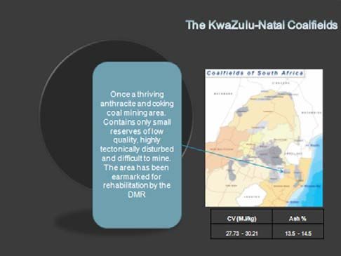
Structurally, the Coalfield is relatively un-deformed with no prominent folding having been identified. Small-scale faulting
(less than 1m) is not uncommon although large-scale faulting is. The only large-scale displacements identified are almost
always associated with transgressive dolerite sills, intruded during the waning stages of the Karoo times. These intrusive
dolerite sills and dykes are related to the Drakensberg Formation flood basalts. The dolerite intrusions adversely affect the coal
seams in the vicinity of the intrusions in terms of coal quality by devolatilising and burning the coal. Large areas of coal have
been rendered uneconomical due to the effects of these dolerite intrusions.
The most important economic coal seams are the No.4 Seam and the No.2 Seam. The No.4 Seam accounts for approximately
80% of the economically recoverable coal within the Highveld Coalfield. The No. 2 and No. 4 Seams are mined in the northern
parts of the Coalfield while only the No. 4 Seam is mined in the southern parts. The bulk of the coal produced is consumed in
power stations and for the production of synthetic fuels. A very limited quantity is exported.

3. Waterberg

                                                                    The Waterberg Coalfield is situated some 400km north west
                                                                    of Johannesburg.
                                                                    This basin is a fault bounded basin with dimensions of
                                                                    approximately 90km E-W and 40km N-S. The faulting
                                                                    plays a distinct role in the preservation and depositional
                                                                    characteristics of the coal occurrences in the region.
                                                                    The two major boundary faults are the Zoetfontein in
                                                                    the north and the Eenzaamheid fault in the south. The
                                                                    presence of post-Karoo faulting has resulted in various
                                                                    portions of the stratigraphy having been preserved. The
                                                                    current weathering surface has a major impact on the
                                                                    relative proportion of the stratigraphy preserved.
                                                                     The major formations of the Karoo Sequence are present
                                                                     within the Waterberg basin but with significant differences
                                                                     in the lithologies and are, with the exception of the Lower
Ecca, all significantly thinner representing much slower rates of subsidence than those encountered in the main Karoo Basin
with the progression from glacial through to aeolian and flood basalts being broadly represented.
The major coal bearing horizons of the Ecca Group are the Volksrust Formation (55m of intercalated mudstones and coal) and
the Vryheid Formation (three major discrete Seams of approx 3m, 9m and 4m, respectively). The most significant difference
to the main Karoo Basin is the fact that the Volksrust Formation is carbonaceous with this formation being represented by
intercalated carbonaceous shale and coal. The vitrinite content of the coal plies to the top of the Volksrust Formation result
in the upper Zones having a semi soft coking coal yield as well as coal for thermal use. While the remainder of the Volksrust
Formation yields low grade thermal coal for power station consumption.
The Vryheid Formation coal Seams are composed of predominantly dull coal with minor carbonaceous mudstone
intercalations again supplied as thermal coals. The Volksrust Formation coals are classified as a thick interbedded Seam
deposit type and the Vryheid Formation as a multiple Seam deposit type.

4. Vereeniging-Sasolburg

The Vereeniging-Sasolburg Coalfield is, according to the 1:250 000 geological map, mainly characterized by mudstone
and sandstones of the overlying Beaufort Group (Adelaide Subgroup). These are underlain by the Volksrust Formation of
the Permian Ecca Group, a formation with a thickness of approximately 100m in the Heilbron area. It consists mostly of
argillaceous rocks which are found on the surface.
The Volksrust Formation consists predominantly of grey to black silty shale, whereas thin siltstone and sandstone lenses/beds,
that are frequently bioturbated, generally occur near the upper and lower boundaries of the succession.
The Vryheid Formation underlies the Volkrust Formation and is the main coal-bearing formation. Outcrops occur in the far
north and east of Coalfield.

                                                                                                                              pg 5
The coal zone in this Coalfield is approximately 40m thick and
                                                                consists of three coal units:
                                                                  •	The lower coal unit can be separated into at most three
                                                                     benches by sandstone partings. The unit has an average
                                                                     thickness of 3m;
                                                                  •	The middle coal unit consists of the No. 2A and 2B Seams
                                                                     and their associate rock layers (resulting in successions
                                                                     that can each be up to 8m thick). This middle unit,
                                                                     however, is not always split by clastic partings; and
                                                                  •	The upper coal unit has a thickness of nearly 5m and
                                                                     includes the No. 3 Seam and the Coal Marker Seam.

                                                                 Later intrusions in the form of dolerite dykes and sills have
                                                                 disturbed the strata. Displacements of up to 85m by the sills
                                                                 are a common occurrence in this Coalfield. Minor faults with
                                                                 maximum displacements of 5m are also encountered in the
region. The general dip in the area is to the south-south-east following the basin morphology. The depth of the coal zone
varies between 125m and 270m, with an average between 180m and 220m. General stratigraphic columns of the Sigma area
suggest that the roof of the ±40m thick coal zone (Coal Marker Seam) occurs at a depth of roughly 180m.
The upper coal unit is situated approximately 20m above the middle unit. This unit is in close proximity to a prominent
dolerite sill of 80m to 100m thickness situated above the coal zone. This has resulted in strata-displacement as well as the coal
of the upper unit having a lower volatile content. The lower and middle coal units are separated by a clastic parting with a
thickness of roughly 5m. The Vryheid Formation is underlain by basement rocks comprising diamictites of the Dwyka Group
and unidentified volcanic rocks.
This Coalfield has been mined for many years and consists out of three economical mineable seams. Coal from the upper
two seams is of lesser quality, but the lower seam is of excellent quality and can be used for the local market, after some
beneficiation. However, as result of a dolomitic basement and its proximity to the Vaal River, environmental objections may
delay any mining project.

5. Ermelo

                                                                   Ermelo Coalfield stretches from Carolina in the north to
                                                                   Wakkerstroom in the south, a distance of some 150km
                                                                   and the east-west extent of the field is some 80km, from
                                                                   about 25km east of Standerton, eastwards to Sheepmoor.
                                                                   It is bounded by the Witbank Coalfield in the north west,
                                                                   Highveld in the west and Utrecht Coalfield to the south.
                                                                   Anthracite has been mined in the Piet Retief, Ermelo,
                                                                   Wakkerstroom areas, but essentially the Coalfield generates
                                                                   bituminous coal. It hosts up to eight coal seams within the
                                                                   middle Ecca Group sediments of the Karoo Supergroup, but
                                                                   not all are present in the various sectors.
                                                                   There are four coal seams which are the most important: A
                                                                   Seam; B Seam, C upper and C lower or Eland, Alfred, Gus and
                                                                   Dundas, depending on which sector is being exploited.

                                                                                                                              pg 6
6. Klipriver

                                                                The Klipriver Coalfield is the largest of the northern KwaZulu/
                                                                Natal Coalfields and historically, the most important. It is
                                                                roughly triangular in shape and the area is bounded on
                                                                the west by the Drakensberg Mountain Range, the Utrecht
                                                                Coalfield in the east and stretches N-S from just north of
                                                                Newcastle to Ladysmith in the south.
                                                                The Coalfield contains sediments of the Dwyka Formation
                                                                overlain by sediments of the Ecca and Beaufort groups of
                                                                the Karoo Sequence. No Pre-Karoo rocks are exposed within
                                                                the area. The Pietermaritzburg formation with a maximum
                                                                thickness of 90m conformably overlies the Dwyka shales. In
                                                                the absence of Dwyka, the Pietermaritzburg Formation lies
                                                                unconformably on the basement rocks.
                                                                In the northern part of the Coalfield, the Top seam has been
                                                                mined extensively but the Bottom seam has better quality
                                                                coal, only mined when it is in close proximity to the Top. In the
southern portion of the Coalfield, the upper seam has also been mined and the bottom seam is not developed to a mineable
thickness. The numerous dolerite sills and intrusions have affected the coal, resulting in a wide range of coal qualities from a
bituminous coal to anthracite. The bottom seam has generally been mined for its coking properties.
There are three operating mines: Aviemore and Springlake (both anthracite) and Magdalena (bituminous/lean coal), plus two
new developing mines: Sesikhona (anthracite) and Uithoek/Burnside (coking coal). The following mines are still producing
today: Aviemore, Magdalena and Springlake. These mines are owned by Slater Coal (Forbes Manhattan) and Shanduka
respectively.

7. Vryheid

The Vryheid Coalfield lies to the east of the Utrecht Coalfield and covers an area of approximately 2 500km2. This Coalfield has
produced some of the best coking coal, anthracite and thermal coal over a number of years. The Dwyka Formation covers
most of the area lying unconformably on the Pre-Karoo sediments. It is composed of diamictites and associated fluvioglacial
sandstones and black shales. It averages 150m in thickness, but it is thicker in Pre-Karoo glacial valleys and thinner or absent
over Pre-Karoo highs. Nine coal seams have been identified within the main coal zone of the Vryheid Coalfield and several of
these have been mined over the last century.
The lowest seam, Targas, occurs sporadically and has not been exploited and is generally thin (0.3m). The Coking seam was
the first of the seams in the sequence to have been mined. The seam is general thin and rarely exceeds 1.0m. This seam
has produced a good quality coking coal, and in some case the raw coal ash content is 7- 8%. The roof of the seam is fairly
competent with medium grained sandstone; however, the floor is mostly fine grained, micaceous sandstone with grey shale
that tends to break up under the mining equipment. The Dundas seam is common in the Coalfield and is split into the Upper
and Lower Dundas. The Lower Dundas varies in thickness from 0.2m to 2.5m and the Upper Dundas is generally thin but
has reached thicknesses of between 1.0m and 1.2m in the northern part of the coal field. The parting thickness between the
seams vary from 1.0m to 6.5m. The roof and floor conditions of these seams are generally poor. These seams have produced
good coking and thermal coal.
The Gus seam has been mined by the majority of the mines and the seam thickness varies from 0.5m to 2.0m. Both a good
quality coking coal and anthracite have been mined from the Gus Seam; it is all dependant on the position of the dolerite.
If the coal has been de-volatilised by the dolerite, good quality anthracite is produced. The coal from the Gus is low in
sulphur and has low phosphorus content, making it a premium produce. The roof is composed of well bedded competent
sandstone, while the floor is a fine to medium grained sandstone with inter-bedded shale which causes problems for mining
equipment because the floor breaks up. The Alfred seam is of lower coal quality than the other seams but the mining height
is approximately 1.5m to 1.8m. The seam yields an average CV of 27MJ/kg, which meets the export qualities. The floor is
competent but the roof conditions are poor with mudstone and shale.
The Fritz seam is the only seam of the minor ones that has any economic potential, because of its coal qualities: low ash, low
sulphur, but this seam thickness is rarely above 0.5m, making it uneconomical to mine.

                                                                                                                              pg 7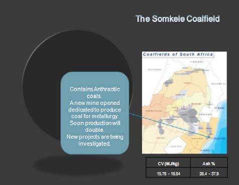
8. Utrecht

The Utrecht Coalfield lies between the Klipriver Coalfield to the west and the Vryheid Coalfield to the east. It is separated from
the Klipriver Coalfield by a barren, dolerite intruded area and from the Vryheid Coalfield by an area where both the seams
have been eroded. Dwyka formation sediments are absent or are thin over most of the Coalfield. Over much of the area, shales
of the Ecca Group directly overlie granite and these shales vary in thickness from 17m to 64m.
The four main coal seams that occur in the Utrecht Coalfield are the Alfred, Gus, Dundas and the coking seam and all
have been mined over the past century. The Coking Seam is the lowest of the mineable seams and is generally thin with
a maximum thickness of 1.5m consisting of good quality mainly bright, thinly banded coal. Roof and floor are normally
competent sandstones and the seam can produce a good quality coking coal with beneficiation.
The Dundas Seam occurs approximately 15m above the coking seam and is of variable quality and thickness. The seam
contains an upper mixed dull and bright horizon, a central bright portion and a bottom mixed coal and shale zone. The seam’s
roof is generally competent sandstone and the floor is shale, which causes problems when being mined. Both anthracite and
bituminous coal can be produced from this seam.
The Gus Seam has been mined extensively in the past and occurs approximately 17m above the Dundas and is generally
thicker than 1.0m in the southern portion of the Coalfield. In the northern part of the Coalfield, the Dundas seam splits into
the upper and lower portions which are separated by sandstone with a thickness ranging from 3m to 12m. The upper portion
of the seam can reach thicknesses of up to 3m. The roof and floor of the Dundas seam are considered variable.
The Alfred Seam is present over the much of the Coalfield and occurs approximately 14m above the Gus seam. The coal is the
thickest of the four main seams, but is generally of poor quality with high ash and high sulphur with a competent floor, but
poor to moderately competent roof.
Five major dolerites are present in the Coalfield and the most persistent is the Zuinguin dolerite that has a thickness in excess
of 150m. The effect of the dolerite intrusions on the coal varies and is related to the thickness, temperature and proximity of
the dolerite intrusions. The dolerite sills that underlie the coal have a greater effect relative to the sills that occur above the
coal seams. The Coalfield is fairly faulted and faulting associated with dolerite intrusions are common with throws ranging
from a few metres up to 150m occurring.
Coal is been mined in the Utrecht Coalfields at Uitkoms by Brandewyn Vallei and over the years, the following mines: Zimbutu,
Umgala, Utrecht, Klipspruit, Longridge, Zoetmelk, Brockwell and Kemplust produced large volumes of coal for both the export
and local markets. The Umgala reserve and the other mines mentioned above still have reserve available. Kangra Holdings still
hold the reserve to Zimbutu, Umgala, Utrecht, Klipspruit and Aasvoelkrans. Some BEE companies hold exploration permits on
Bloemendal, Commissiekraal and Zoetmelk.

9. Nongoma

                                                                This Coalfield stretches from just south of Zululand Anthracite
                                                                Colliery (ZAC), 27km NE of Ulundi and northwards to the
                                                                southern Swaziland border. The Coalfield has two identified
                                                                areas, the southern area which is currently being mined by ZAC
                                                                and the Nongoma Reserve in the north.
                                                                The strata in the Nongoma region are effectively horizontal,
                                                                but with gentle dips to the east and south of Nongoma. The
                                                                coal seams of the Vryheid Formation (Middle Ecca) occur within
                                                                this Coalfield, but the seams are generally thin. However, the
                                                                Beaufort Formation has also been reported in this area. The
                                                                coal seams in the ZAC area are severely faulted and have dips
                                                                of up to 12 degrees. Dolerite sills and dykes are common in the
                                                                Coalfield and numerous faults occur that break the coal reserve
                                                                into smaller coal blocks and these increase the mining problems
                                                                within the blocks.
Only one seam, the Main seam, has been developed by ZAC to a mineable thickness of between 1m and 3m.

                                                                                                                                pg 8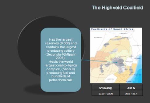
10. Somkele
It stretches from a few kilometres south of Empangeni to some
25km north of Mtubatuba, a total length of 60-70km. From
west to east it runs from the Umfolozi-Hluhluwe Game Reserve
for about 10km. The only operating colliery is Somkele mine.
Previous mining operations were conducted in the early 1900s
and in the 1940s. Somkele mines the main seam, about 16km
north west of Mtubatuba, producing high quality anthracite.
The coal seam is generally steep, dipping at 10-25° to the east.
Faulting is common and the coal measures have been intruded
by dolerite dykes and sills. The dykes vary in thickness from 10m
to 30m and sills overlay or underlie the coal seams. The seam,
which is part of the Beaufort Formation, has a total width of 13
to 14m, made up of three units, the Top, Middle and Bottom with
widths of 2, 3 and 3m, separated by carbonaceous shales.
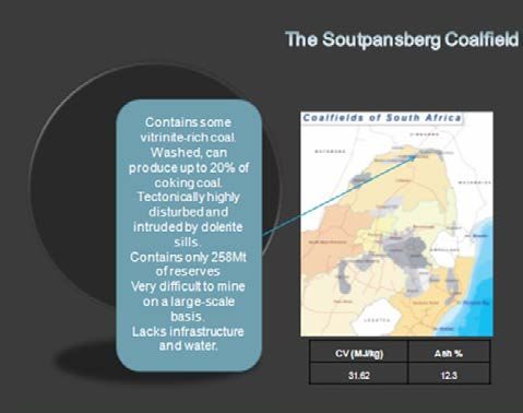
11. Soutpansberg
It is situated some 30km to the north of Makhado (Louis
Trichardt) on the northern side of the Soutpansberg. It stretches
from Tolwe in the west to the Mozambique border under the
Kruger Park – a distance of 290km. The Coalfield is divided into
three sub-basins: West, Central and East. The sub-basins are fault
bounded remnants of the Karoo sequence.
The coal bearing area is the Madzaringwe Formation, which is a
very thick sequence of carbonaceous siltstone, mudstone and
coal. Predominantly, the coal in these areas is bright coal with
high vitrinite content. The full Madzaringwe formation is in the
order of 40m in thickness.
The total coal bearing horizon is on average 30m in width, with
alternating coal and carbonaceous bands. There is only one
operating mine, Tshikondeni which produces coking coal.
12. Kangwane
It lies to the north of Swaziland and forms part of the Coalfield
which stretches from Nongoma in the south, through Swaziland
to the southern boundary of the Kruger National Park. Faulting is
common and the coal measures have been intruded by dolerite
dykes and sills. The dykes vary in thickness from 10m to 30m and
sills occur above and below the coal seams.
Three anthracite seams occur in the Coalfield, namely the Lower,
Middle and Upper seams.
There is only one mine operating in the Kangwane Coalfield,
which has been in operation since 1987: Nkomati Anthracite.
pg 913. Thuli
This Coalfield stretches for some 75km, from about 15km west
of Pontdrif to about 35km west of Musina, with the Limpopo
River as its northern boundary. Its maximum N-S width is 20-
25km at its western end, tapering north eastwards to almost
a point at its eastern limit. Thuli continues across the Limpopo
into Botswana and Zimbabwe.
The geology of the area is dominated by rocks of the Beit
Bridge Complex that were subjected to granulite-grade
metamorphism during the Limpopo Orogeny (2.7 GA), and
comprises the Malala Drift Group into which the Alldays Gneiss
and Messina Suite are intrusive. These basement rocks are
covered by Karoo Supergroup sediments.
The Malala Drift Group is made up of leucogneiss, amphibolite
and metapelite. The Karoo Supergroup consists of the Tshidzi,
Madzaringwe, Mikamdeni, Fripp and Solitude Formations and is
made up of sandstone, shale and coal.
Tertiary Deposits that overlay the above rocks are represented by calcretized sand and gravel, and consolidated silty sand.
These sediments, which occur in proximity to major rivers and streams, are generally overlain by red sand. The area is further
characterized by the Limpopo (Tuli) Coal Field, a synclinal folded basin containing a coal zone of up to 15m in width which
consists of a Top, Middle and Bottom unit, plus sub-units.
At present, no mining is taken place, but a new mini, Vele, is currently being developed in the north eastern sector, which will
produce mixed coking and power station coals.
pg 10THE SOUTH AFRICAN COAL MINES
WITBANK COALFIELD
NO NAME OF MINE ROM PRODUCTION (Mt) OWNER
1 Douglas Middelburg Operations 16.7 Becsa
2 Khutala Colliery 12.2 Becsa
3 Matla Colliery 11.2 Exxaro
4 Optimum Colliery 9.5 Siyanda Coal
5 Graspan Leeuwfontein Lakeside Bankfontein 9.0 Shanduka Coal
6 Goedehoop Colliery 7.1 Anglo Coal
7 Zibulo Colliery 6.6 Anglo Inyosi Coal
8 Arnot Colliery 5.2 Exxaro
9 Arthur Taylor Opencast Mine - (ATCOM) 4.9 Xstrata Coal SA
10 Tweefontein Colliery 4.8 Xstrata Coal SA
11 Middelkraal Colliery 4.5 Umcebo Mining
12 Mafube Colliery 4.4 Anglo Coal & Exxaro
13 Kleinkopje Colliery 4.1 Anglo Coal
14 Goedgevonden Colliery 4.1 Xstrata Coal SA
15 Landau Colliery 3.9 Anglo Coal
16 Greenside Colliery 3.7 Anglo Coal
17 Klipspruit Colliery 3.6 Becsa
18 Glisa Colliery 3.5 Exxaro
19 Vuna Colliery 3.5 Vuna Mining
20 Leeuwpan Colliery 2.5 Exxaro
21 Leandra Block 0.0 Becsa
1. Douglas-Middelburg Operations
DMO is situated some 25km south east of Witbank and east of the Duhva Power Station. The DMO area stretches from the N4
highway south to the Oliphants River at Van Dyksdrift. The coordinates of the mine are Lat: 25.940689S; Long: 29.392327E.
The mine is on the Farms Hartbeestfontein 339 JS, Driefontein 338 JS, Wolkekrans 17 IS, Vlaklaagte 21 IS as well as other
surrounding properties. DMO is wholly owned by BHP Billiton Plc.
The Douglas Middelburg Operations will produce about 10Mtpa to 12Mtpa for export and a further 10Mtpa for Eskom. It is to
maintain exports at around the current level of 12Mtpa and fulfil ongoing domestic contractual commitments to Duhva Power
Station.
The scope of the project is to include further development of existing coal reserves, development of new mining areas with
low strip ratio, and investment in new infrastructure including a 14Mtpa coal processing plant and high-capacity overland
conveyor system. The new coal processing plant will replace the existing, less efficient washing plant at Douglas.
The DMO project will allow BECSA to realise maximum value from its assets by utilising the existing reserves at Douglas and
MMS, thus enabling it to maintain exports through to 2034. Export coal is transported to RBCT by rail, while the domestic coal
is transported via conveyor belt to the nearby Duvha Power Station. Beneficiation facilities consist of the following: tips and
crushing plants, two export wash plants, a middlings wash plant and a de-stone plant. The overall capacity is 30Mtpa.
DMO is a large opencast strip mine, producing over 22Mtpa ex-pit with six large draglines.
pg 11Typical DMO Export Coal qualities:
Calorific Value MJ/kg 27.8 27.5
Calorific Value kCal/kg 6050* 6030*
Ash % 14.6 12.65
Volatile Matter % 23.6 23.3
Sulphur % 0.53 0.44
Inherent Moisture % 2.52 2.27
2. Khutala Colliery
Khutala is situated some 36km south west of Witbank and lies to the south of the N12 highway to Johannesburg. The
coordinates of the mine are Lat: 26.124238S; Long: 29.004242E. It is on the Farms Zondagsvlei 9IS, Schoongezight 218IR,
Leeuwfontein 219IR as well as other surrounding properties. Khutala is wholly owned by BHP Billiton Plc.
Khutala Colliery is an underground and opencast mine producing 15Mtpa for sale to Eskom on a cost plus basis. It is situated
100km east of Johannesburg, and is a combination of an opencast and underground mine. Domestic coal is transported via
overland conveyor to the Kendal Power Station.
Beneficiation facilities consist of a crushing plant for the energy coal with a nominal capacity of 18Mtpa. A separate smaller
crusher and wash plant with a nominal capacity of 0.6Mtpa is used to beneficiate the metallurgical coal supplied from the
opencast operation.
3. Matla Coal
Matla Colliery is situated 42km south-south-west of Witbank and about 24Km south-south-east of the town of Ogies. The
coordinates for the mine are Lat: 26.259171S; Long: 29.121065E. It is on the Farms Haasfontein 85IS, Grootpan 86IS, Vierfontein
61IS as well as other surrounding properties. Matla is wholly owned by Exxaro.
This mining complex comprises three mines producing 14Mtpa for Eskom. It is a fully mechanised underground mine
employing continuous mining and shortwalls. The thermal coal is supplied to Eskom’s Matla power station in terms of a cost-
plus agreement, reviewed annually, with a variable return payable by Eskom for any excess tonnage produced.
4. Optimum Colliery (Optimum Coal Holdings Pty Ltd)
The company is listed on the JSE. The colliery is situated ±30km south east of Middelburg on the road to Hendrina/Ermelo. The
coordinates are Lat: 26.0060055S; Long: 29.630975E. The mine is on the Farms Optimus 480 JS, Pullenshope 155 IS, Optimum
554 IS as well as Kromdraai, Boschmanspoort, and Boschmanskop. Formed in 2007, Optimum Coal is South Africa’s sixth-
largest thermal coal producer and fourth-largest exporter after Anglo Thermal Coal, BHP Billiton Energy Coal South Africa and
Xstrata Coal.
Optimum bought the Optimum Colliery in 2008 from BHP Billiton Energy Coal (BECSA). It took over the coal supply agreement
as part of the deal and has an export sales arrangement with BECSA that runs until 2021.
The company’s operations are located mainly in the Mpumalanga province and include Optimum Collieries and Koornfontein
Mine, in which it currently has an effective 96% interest.
The estimated life of the Optimum Colliery mine is 22 years and that of Koornfontein is 18 years. Export sales are made
through RBCT, in which Optimum Coal has control over 8.4Mt of entitlement.
Optimum Coal is contracted to supply 5.5Mtpa to Eskom’s Hendrina power station and has in the past supplied as much as
6.5Mtpa. The potential exists that Koornfontein will supply coal to Eskom’s nearby Komati power station and that Optimum
Coal’s Overvaal project could supply coal to Camden power station.
The company estimated a run of mine production from Optimum Collieries of between 15 and 16Mt for the current financial
year to the end of June 2011, with up to 6Mt going for exports and 5.5Mt to Eskom. Koornfontein Mines is expected to
produce up to 1.8Mt of exportable coal and 1.2Mt for Eskom and the inland market.
pg 12The production is achieved from opencast and underground operations. With the opencast mine contributing to the major
part of the production and a mining contractor doing the underground mining currently. Beneficiation facilities include tips
and crushing plants, an export washing plant and a de-stoning plant. The overall capacity is 17Mtpa.
Optimum Coal also received the right to export 6.5Mt of coal via RBCT, making the company the fourth-largest shareholder
after Anglo American, BHP Billiton and Xstrata. BHP Billiton holds the rights to market all of Optimum’s export coal until 2021.
The mine has a resource of over 700Mt and a viable coal reserve of 300Mt, giving a 25 year life-of-mine projection which
equates to 191Mt saleable coal.
The company has two coal development projects. These are the Vlakfontein project, near Ermelo, and the Overval project
in the Camden area, adjacent to Coal of Africa’s Mooiplaats operation. Warrior Coal, who is a partner in Optimum, also holds
other coal rights in Mpumalanga and Limpopo.
5. Shanduka Resources
Graspan, Leeuwfontein, Lakeside, Bankfontein, Middelburg Townlands and Springlake Colliery are all part of the Shanduka
group. In addition to these assets, Shanduka Resources has a 26% shareholding in Kangra Coal, which owns Balgarthan,
Savmore, Taaiboschspruit and Welgedacht collieries in Mpumalanga. Kangra Coal also has a small stake in RBCT.
Shanduka Coal mines produce approximately 9Mtpa and have a reserve base of 92Mt of Bituminous coal and 35Mt of
anthracite.
The Graspan colliery supplies some 3Mtpa of coal to the domestic and export market. Shanduka owns 30% in Graspan and
Glencore 70%.
6. Goedehoop Colliery
The colliery is situated about 40km south east of Witbank, between the R554 road to Belfast and the R35 from Middelburg to
Bethal and 6km west of the Komati Power Station. The coordinates of the mine are Lat: 26.102709S; Long: 29.40816E. It is on
the Farms Goedehoop 46IS, Haasfontein 28IS and Enkeldebosch 20IS as well as other surrounding properties.
Goedehoop is wholly owned by Anglo Coal. The colliery was established in April 1983 and underwent a merger with Banks
Collieries in 2005. It produces more than 11Mt from the No. 2 and No. 4 coal seams from four underground operations.
These include the Hope, Vlaklaagte, Simunye and South shafts. Coal is also mined from the Vlaklaagte and Haasfontein mini-
pit operations. Two processing plants produce 7.5Mtpa of saleable coal, which is sold mainly to the export market.
Mining boundaries cover an area of some 28 000 hectares. Current life of mine runs until after 2035 and the resource is
calculated at 310Mt.
7. Zibulo Colliery
Zibulo Colliery is situated immediately north west of Ogies, Mpumalanga opposite Klipspruit Colliery and is the first of several
Anglo Inyosi coal mines to come on stream. The coordinates of the mine are Lat: 26.04418S; Long: 29.044609E. It is on the
Farm Oogiesfontein 4 IS as well as other surrounding properties.
Zibulo Colliery is 73% owned by Anglo Coal. Anglo Inyosi Coal, a broad-based black economic empowerment (BBBEE)
company is 73% held by Anglo American, with the remaining 27% own by Inyosi, a BEE consortium led by the Pamodzi and
Lithemba consortia (66%), with the Women’s Development Bank and a community trust holding the remaining equity.
The new Zibulo multi-product mine was previously known as the Zondagsfontein project and the greenfields projects of
Elders, New Largo and Heidelberg. The colliery forms part of the Witbank Coalfield and comprises both an underground
and opencast operation. Its underground mine will mine a 7Mtpa from No. 2, No. 4 and No. 5 coal seams and its opencast
operation will produce 1Mtpa of coal.
Zibulo “Zondagsfontein” will be a multi-product mine for Eskom and the export market. It is situated close to BHP Billiton’s
Klipspruit and contains a resource of about 100Mt. Primary export product is railed to the Richards Bay Coal Terminal and
secondary middlings will be sold to the local market.
pg 13Phola Coal Processing
The Phola coal processing plant is a 50:50 joint venture between Anglo Inyosi Coal (AIC) and BHP Billiton Energy Coal South
Africa (BECSA) and is fed equally by AIC’s Zibulo Colliery and BECSA’s Klipspruit mine that will supply 3.3Mtpa to Eskom and
export another 3.3Mtpa.
The project includes run-of-mine storage and materials-handling systems, domestic and export product storage, rail lines and
two rapid rail load-out stations. Operation of the Phola plant has been outsourced to a company that will also take charge of
coal loading for road and rail transport, as well as managing the discard and tailings storage. Zibulo will deliver 6Mtpa from
underground and surface for 20 years, from reserves of more than 250Mt.
8. Arnot Colliery
Arnot Colliery is situated 40km south east of the town Middelburg and about 12km south of the N4 highway to Nelspruit. The
coordinates for the mine are Lat: 25.946414S; Long: 29.809381E. It is on the Farms Rietkuil 491JS and Nooitgedacht 493JS, as
well as other surrounding properties.
Arnot is wholly owned by Exxaro. The mine extracts coal using both underground and opencast operations and produces
5Mtpa of power station coal. Arnot uses mechanised mining methods and continuous mining processes. The mine is
contracted to supply Eskom’s Arnot power station until 2030 and the contract is a “cost-plus” agreement in which there is a
return on investment and a management fee.
9. Arthur Taylor/ ATCOM
It is part of the Xstrata’s Impunzi division. ATC/ATCOM Collieries are situated 14km south east of the town Ogies and 24km
south-south-west of Witbank. The mine is north of the Ogies – Bethal road, the R545. The coordinates are Lat: 26.10281S; Long:
29.175896E. It is on the farms Blesbokfontein 31IS, Kromfontein 30IS and Klipplaat 14IS.
ATC and ATCOM are wholly owned by Xstrata. IMpunzi Division consists of both underground and opencast mines; Arthur
Taylor Colliery (ATC), underground, ATCOM, opencast, Phoenix underground and Tavistock, underground, with a total reserve
of over 160Mt.
These collieries are situated in the Witbank Coalfield between the national roads R545 and R547. They produce approximately
3.6Mtpa and have a total resource of 80Mt. Arthur Taylor colliery and ATCOM have a clean-coal stockyard system and rapid
load out systems. Both these collieries use draglines in their opencast operations.
10. Tweefontein Collieries (Boschmans, Witcons and Waterpan)
Boschmans, Witcons and Waterpan are located 23km and 28km south west of Witbank respectively; they mine the
Boschmansfontein 12IS, Tweefontein 13IS, Zaaiwater11IS and Blesboklaagte 31IS farms. The collieries are owned by Xstrata
(79.8%) and African Rainbow Minerals (ARM), 20.2%.
The mines are in the Karoo Supergroup on the northern margin of the Witbank Coalfield. The Dwyka Tillite is overlain by
sediments of Ecca, Beaufort and Stormberg Groups. Coal measures are associated with the Vryheid Formation of the Lower
Ecca Group of Permian age. The No. 1, 2 and 4 Seams are present, but only the thick No. 4 seam is presently being mined.
They form part of Xstrata’s Tweefontein Division. Boschmans produced first in 1989, Witcons in 1981 and Waterpan in
1994. Boschmans produces around 2.8Mtpa of coal for exports and the domestic market, Witcons an estimated 1Mtpa of
beneficiated coal for export with a calorific value of 6 640kcal/kg GAR and ash content of 13%.
A Bord and pillar mining is used at Boschmans, with continuous miners. Raw coal is produced from five continuous miner
sections. Witcons has underground and surface operations, mining the No. 2 and No. 4 Seam of the Witbank Coalfield. The
underground operations were converted to continuous miner sections to improve efficiencies and maintain costs. The
underground mine is bord and pillar, utilising continuous miners and the surface mine is a truck and shovel operation.
Waterpan was developed as an opencast and underground operation, but the underground section was closed in 2006. It is
now a truck and shovel operation mining the No. 2 and No. 4 Seam.
Boschmans and Witcons ROM coals are transported to the plant by conveyor belts. The Boschmans 800tph capacity
washing plant produces sized coal from the Wemco drums and duff from the cyclones and spirals. A lower grade product is
pg 14produced in a middlings plant for the domestic power industry. Witcons coal from the opencast operation is tipped onto the
underground conveyor belt for the stockpile. Coal for exports is produced from dense medium cyclones and spirals. Waterpan
ROM coal is transported to the plant by road. The 200tph coal plant has dense medium cyclones and spirals to produce export
coal. Lower grade coal, mainly for Eskom, is beneficiated in a middlings plant.
Tweefontein Collieries produce a beneficiated coal for the exports and middlings for Eskom. An estimated 4.7Mtpa of the total
6Mtpa of the saleable production is sold into the export market with a calorific value of 6 640kcal/kg GAR and ash content of
13.5%. Tweefontein coal is loaded onto trains at the Saaiwater rail siding and railed 596km to the RBCT.
Xstrata has a shareholding capacity to export 15.5Mtpa via the RBCT, which equates to 20.9% of the terminal’s original
nominal capacity of 72Mtpa. Arm Coal has 3.2Mtpa of allocation as part of the RBCT Phase V. Boschmans , Witcons and
Waterpan mining costs are R78.59/t, R105.93/t and R74.07/t respectively.
11. Middelkraal Colliery
Middelkraal Colliery is situated 30km north of the town Bethal along the R35 and 48km south of Middelburg. The coordinates
for the mine are Lat: 26.194369S; Long: 29.477335E. It is on the Farm Middelkraal 50IS. Middelkraal is wholly owned by
Umcebo Mining. Before mining could commence, 16 houses from an informal settlement on Middelkraal Umcebo’s coal mine
property had to be relocated.
Middelkraal produces over 4.1Mt of coal for the energy market utilising Truck and Shovel operations. This coal is crushed,
screened and processed in an air jig plant and transported to the power utility sites. The total reserve is estimated to be in the
order of 30Mt, giving the mine a life of 6 years.
12. Mafube Colliery
The colliery is situated about 30km east of Middelburg between the R104 road to Belfast and the N4 Highway and 14km north
of the Arnot Power Station. The coordinates of the mine are Lat: 25.823463S; Long: 29.74347E. It is on the Farms Elandsfontein
433JS, Kleinfontein 432JS and Springboklaagte 416JS as well as other surrounding properties. Mafube is 50% owned by Anglo
Coal.
Mafube coal mine
Mafube is a 50:50 joint venture partnership between Anglo Coal and Exxaro. The project has been completed and the
ramp-up to full capacity was reached by end-2008. At full production, the mine will produce 3Mtpa of export steam coal and
2Mtpa of power station coal. The mine is situated on the Arnot North coal reserve, 30km east of Middelburg in the coal-rich
Mpumalanga Province. The project will have a life of about 23 years.
Mafube covers three reserve blocks, the Springboklaagte, Veldfontein and Nooitgedacht blocks. The 367-ha Springboklaagte
block is the current focus of Mafube’s activities. The Springboklaagte block represents a reserve of 67Mt, while another 8Mt
is in the Veldfontein block. The Nooitgedacht block contains a further 58Mt. Even with the mine’s increased production of
4.5Mt of saleable coal, it will have a life of more than 22 years. The mine has a stripping ratio of about 3.5:1. However, this will
increase over time. The overburden runs from some 8m to 30m at its deepest point.
The colliery started out as a mini-pit operation in June 2004, to supply coal to Eskom’s Arnot Power Station. Since its final
commissioning in January 2008, it has grown to produce 2.5Mtpa of low ash coal for export and 1.7Mtpa of steam coal for the
domestic thermal market.
13. Kleinkopje Colliery
The colliery is situated approximately 15km due south of Witbank on the right hand side of the road to Vandyksdrift and forms
part of the South African Coal Estates Complex. The coordinates of the mine are Lat: 26.012699S; Long: 29.225689E. It is on the
Farms Kleinkopje 15IS, Klippan 332JS and Groenfontein 331JS as well as other surrounding properties. Kleinkopje Colliery is
wholly owned by Anglo Coal.
It is currently mining the reserves contained in its No’s 1, 2 and 4 seams, and has also gained more reserves from the nearby
Greenside underground colliery, thus increasing its reserves from 216Mt to 279Mt.
pg 15Kleinkopje mines new reserves as well as large areas previously mined underground using bord and pillar techniques. Its
principal product is steam coal for the export market and a fraction for the inland or local market.
The washed coal is transported by an 8.5 kilometre overland conveyor belt to the company’s Rapid Loading Terminal. The
mine produces between 4 and 4.5Mtpa but will be increasing its Run of Mine (ROM) production to 7.6-9.3Mtpa. Approximately
50% of the coal produced is sold to Eskom.
14. Goedgevoden Colliery
Goedgevoden Colliery is situated 6km due south of the town Ogies and 38km east of Delmas. The mine is adjacent to the
Leslie - Ogies road just off the R545. The coordinates are Lat: 26.09183S; Long: 29.053069E. It is on the Farm Goedgevoden
10IS.
Goedgevoden is an opencast coal mine. It is a new large-scale, long-life, low-cost mine with new infrastructure and produces
on average 12Mtpa of ROM coal per year. It exports 3.2Mtpa via Richards Bay and supplies 3.5 Mtpa to Eskom at an overall
yield of 55%. The expected life of mine is 30 years, based on the 221Mt resource.
The shareholding in Goedgevoden is as follows: Arm Coal 51% and Xstrata SA 49 %. The coal reserves are 357Mt with a low
average strip ratio of 2.2m³/t (bcm/t). The Richards Bay coal terminal allocation for Goedgevoden is 3.5Mtpa based on the
current allocation of Phase V. Goedgevonden will supply approximately 60Mt of thermal coal (3.5Mtpa) to Eskom’s Majuba
coal-fired power station until 2026.
15. Landau Colliery
The colliery is situated about 17km north west of Witbank between the R544 road to Verena and the N4 Highway on the
right hand side of the road to Bronkhorstspruit. The coordinates of the mine are Lat: 25.79143S; Long: 29.082672E. It is on
the Farms Kromdraai 279JS, Merwede 272JS and Coronation 280JS as well as other surrounding properties. Located in
Witbank, Mpumalanga, Landau colliery forms part of the South African Coal Estates Complex and comprises four sections –
the Kromdraai opencast mine, Excelsior, the Schoongezicht mini-pit and the Umlalazi mini-pit. Landau Kromdraai Colliery is
wholly owned by Anglo Coal.
Kromdraai mines the No. 1 and No. 2 seams and has a reserve of 132Mt, producing 6.1Mtpa using a Dragline and truck and
shovels. The Kromdraai reserves will provide a life-of-mine to 2020, after which the operation will move to the second site at
the former Navigation Colliery where there exists reserves for another 11 years. Both the Kleinkopje and Kromdraai operations
are mining pillar areas that have spontaneous combustion problems. Opencast mining methods are used and the No. 1 and
No. 2 seams are mined in a drill and blast operation with one dragline, two hydraulic shovels and four haul trucks. There is
a sandstone rock parting between the two seams. The No. 1 seam was previously mined by underground mining methods
and the pillars are now being extracted from the old underground workings. The No. 2 seam was not mined before. Landau
consists of two sites: Navigation plant and Kromdraai opencast. The sites are 23km apart, with a rail link to transport mined
coal to the plant. The Navigation plant uses dense medium separation methods.
Landau mines 6.5Mtpa and produces 4.2Mtpa sales. Most of the coal produced at Landau is exported through the Richards
Bay Coal Terminal. A small portion is supplied to the inland market. A total of 3.1Mt of coal is produced for the export market
annually and is conveyed to the company’s Rapid Loading Terminal for transportation to the Richards Bay Coal Terminal.
A further 900 000t are provided for the domestic market and dispatched by road and rail. Some 210 000t of coal a year are
currently supplied to Eskom for power generation.
16. Greenside Colliery
Greenside Colliery is located approximately 15km south west of Witbank and is adjacent to the N12 highway to Johannesburg.
The coordinates of the mine are Lat: 25.960292S; Long: 29.185751E. It is situated on the Farms Groenfontein 331JS and
Klipfomtein 332JS as well as other surrounding properties. Greenside colliery is wholly owned by Anglo.
It forms part of the South African Coal Estates Complex (SACE), which includes Landau and Kleinkopje Collieries. The mine
was established to supply coal to overseas markets through the Richards Bay Coal Terminal, as well as a small quantity of coal
for domestic use. Its total output is 4.4Mtpa run of mine which equates to 3.1Mt of saleable coal. It has four underground
continuous miner sections.
pg 1617. Klipspruit Colliery
Klipspruit Colliery is situated some 27km south west of Witbank and lies to the south of the N12 highway to Johannesburg just
outside of the town of Ogies. The coordinates of the mine are Lat: 26.050481S; Long: 29.038797E. It is on the Farms Klipfontein
3IS, Smaldeel 1IS as well as other surrounding properties. Klipspruit is wholly owned by BHP Billiton Plc.
It is the only BECSA mine not contracted to a power station; the mine produces approximately 4Mtpa of coal from its opencast
operation utilizing a single dragline. The production is expected to double to 8Mt; then Klipspruit would export 4.5Mtpa and
sell 2.9Mtpa to Eskom. It has a reserve of 160Mt giving it a life of mine of 20 years.
The No. 2 and No. 4 seams are mined and the coal is currently being processed at Rietspruit Colliery until the beneficiation
plant and load out facilities for Klipspruit are completed at the new Phola Coal Processing Plant (a 50/50 JV between Anglo
and BECSA). The increased coal production will supply both Eskom, as well as export customers. The coal will be processed by
the Phola Coal Processing Plant, which will process 16Mtpa - 8Mtpa for each partner. The cost/sale per ton in July 2009 was
R240/ton FOR. The Stripping Ratio on average is 2.3bcm/t.
18. Glisa (North Block Complex)
The North Block Complex consists of Glisa and Strathae, and also the Eerstelingfontein and Belfast projects. The operations are
situated in Mpumalanga province between the towns of Carolina, Arnot and Machadodorp. The North Block Complex is 100%
owned by Exxaro. The mining rights for the North Block Complex are still waiting for the conversion to new order rights.
The coal reserve at Eerstelingsfontein is contained in a single seam, the No.2. It occurs as an erosional remnant on high ground
at shallow depths, suitable for opencast mining. The thickness of coal ranges from 0.5-3.1m, with an average thickness of
2.3m. The coal is at a relatively shallow average total depth of 10.69m. The maximum depth to top of coal in the area is 17.8m.
The North Block Mining Complex was established in 2001, mining Glisa’s underground and surface reserves. Glisa South’s
underground operation was developed in 2006 after depletion of the underground reserves. Glisa’s opencast mine in
portion 24 of Paardeplaats 380JT, for Eskom, was depleted by mid-2006. Strathrae, which was acquired from Xstrata, was
commissioned in October 2004. The colliery produces coal for Eskom and metallurgical coal for the domestic market.
Eerstelingsfontein will be mined by opencast methods using the strip mining method and the coal will be transported to the
Strathrae plant. A feasibility study is been conducted for the Belfast underground and surface project.
Mining at Glisa’s underground operation is bord and pillar using a Voest Alpine AM80 and Wirth continuous miner with six
shuttle cars. Strathrae’s surface operation mines the No.2 Seam using the truck and shovel mining method. ROM coal from the
underground operations is transported to the plant by a conveyor belt. The thermal coal and high grade coal plants each have
a capacity of 300tph. Strathrae’s plant, with 130ktpm capacity, is a beneficiation plant producing export quality coal.
The North Block Complex produces coal for the domestic and export markets. Coal from Glisa’s underground operation
is predominantly crushed and screened and sold to Eskom. The prime product is sold into the export market. Coal is
beneficiated at the Strathrae plant for exports and the middlings sold to Eskom.
Export coal is railed 576km to the RBCT. Exports from the North Block Complex are expected to increase when Exxaro
Resources increases its RBCT entitlement. Exxaro Resources could become a major exporter via the RBCT with exports
reaching 6.3Mtpa. The North Block Complex’s FOB cash costs are R328.43/t, while Domestic FOT cash costs are R100.60/t,
mainly due to low crushing and screening costs.
19. Vulna Colliery (Zonnebloem)
Zonnebloem is situated 2km east of Middelburg and just north east of Pan Siding on the mainline to Maputo. The coordinates
for the mine are Lat: 25.746999S; Long: 29.702792E. It is located on the Farm Patattafontein 412JS. Vuna Coal, the Zonnebloem
reserve has a resource of approximately 15Mt, all opencastable, and will be mined approximately at a rate of 360 000tpm.
This tonnage will be road hauled to the Woestalleen plant for processing. Some of this coal will be sold on ROM basis to other
companies.
NuCoal acquired 49% stake in Vuna coal from the BEE consortium in 2007, Vuna coal holds the mining rights to the farm
Zonnebloem and has an exclusive off-take agreement for all ROM coal, which feeds the wash plant at Woestalleen. The plant
yield is approximately 63% and the mining costs are R130/t.
pg 17You can also read