Special Climate Statement 71-severe fire weather conditions in southeast Queensland and northeast New South Wales in September 2019 - 24 September ...
←
→
Page content transcription
If your browser does not render page correctly, please read the page content below
Special Climate Statement 71—severe fire weather
conditions in southeast Queensland and northeast New
South Wales in September 2019
24 September 2019
Special Climate Statement 71—severe fire weather southeast Queensland and northeast New South Wales in September 2019
Version number/type Date of issue Comments
1.0 24 September 2019
Unless otherwise noted, all images in this document except the cover photo are licensed under
the Creative Commons Attribution Australia Licence.
© Commonwealth of Australia 2019
Published by the Bureau of Meteorology
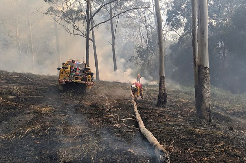
Cover image: Queensland Fire and Emergency Services, September 2019
2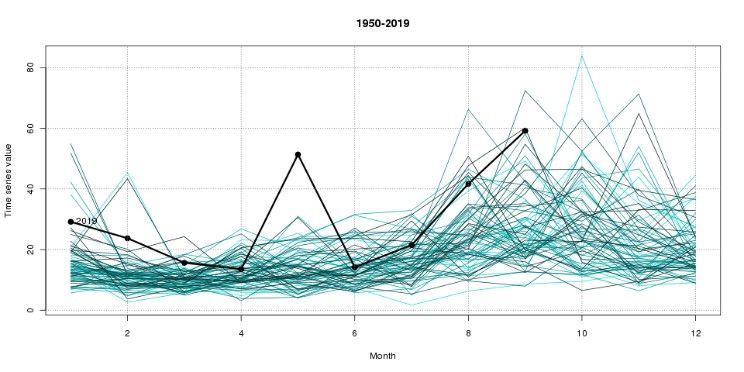
Special Climate Statement 71—severe fire weather southeast Queensland and northeast New South Wales in September 2019

Table of contents
Executive summary ..................................................................................................................................................... 4

Introduction .................................................................................................................................................................. 6

1.       Preceding climate conditions ............................................................................................................................ 7

2.       Meteorological drivers ..................................................................................................................................... 13

3.       Temperature .................................................................................................................................................... 14

4.       Strong winds .................................................................................................................................................... 17

5.       Fire weather .................................................................................................................................................... 19

6.       Documented impacts of the conditions ........................................................................................................... 25

7.       Historical and future trends ............................................................................................................................. 27

8.       Previous notable events .................................................................................................................................. 29

Tables ........................................................................................................................................................................ 31

References and further information ........................................................................................................................... 35

                                                                                                                                                                                3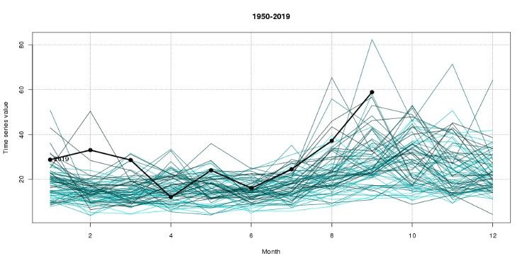
Special Climate Statement 71—severe fire weather southeast Queensland and northeast New South Wales in September 2019

Executive summary
   •   From 6 September, areas of northeast New South Wales and southeast Queensland had warmer than
       average daytime temperatures, very low humidity, and gusty winds leading to dangerous fire weather
       conditions.

   •   In these areas, fire risk was exacerbated by rainfall that was below average on a range of timescales from
       months to years, leading to a prolonged and severe drought and very high dryness factors for fuels.

   •   Maximum temperatures on the 5th and 6th were more than 10 °C above average in some areas.

   •   Many locations in the affected areas experienced January to August rainfall totals that were 50 per cent
       below average, and some locations had their driest January to August period on record since (at least)
       1900.

   •   In addition to large year-to-date rainfall deficits in 2019, below average rainfall totals in 2017 and 2018 saw
       large multi-year rainfall deficits accumulate in areas on and west of the ranges in northern New South
       Wales and southern Queensland. Rainfall over much of this area had been lowest on record for the 20
       months starting January 2018, and the 32 months starting January 2017.

   •   Trends towards a lengthened fire season have already been discerned in some areas of the country, with
       the fire season typically starting earlier in the year in southern Queensland, inland and southern New
       South Wales, and Victoria.

                                                                                                                     4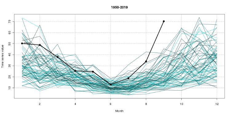
Special Climate Statement 71—severe fire weather southeast Queensland and northeast New South Wales in September 2019
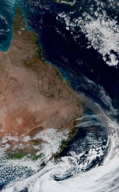
Figure 1: Satellite image from Himawari-8 on 6 September 2019 22:30 UTC showing plumes of smoke extending
eastwards from fires burning in New South Wales, and dust blowing southeast off the Queensland coast. An
intense low pressure system and associated large cloudband was situated southeast of the mainland.
5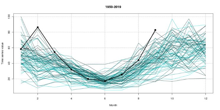
Special Climate Statement 71—severe fire weather southeast Queensland and northeast New South Wales in September 2019

Introduction
In coastal areas of southeast Queensland and northeast New South Wales, September has historically been the
month with the highest Forest Fire Danger Index (FFDI) values of the year1. Further inland in eastern Australia, the
highest FFDI values are typically late in spring, while in southern Australia fire danger typically peaks in summer.
The daily FFDI values observed during this event were above anything previously observed in most of these areas
so early in September, compared to observations since 1950. This Statement discusses these conditions and the
factors that contributed to the situation on a range of timescales.

Areas in the southern districts of Queensland and northeast New South Wales were primed for high fire danger
ratings. Rainfall for January to August 2019 was very much below average to driest on record in some localities,
along with very much warmer than average mean maximum temperatures. These areas largely overlap with the
northern Murray–Darling Basin, which has had very much below average rainfall and warmer than average
maximum temperatures since 2017 2.

On Friday 6 September, strong west to northwesterly winds ahead of the passage of a surface trough produced
extreme to locally catastrophic fire conditions in the Warrego and Maranoa, and Darling Downs and Granite Belt
districts of Queensland, and the northeastern districts of New South Wales.

For the Southern Downs Region, the fire weather during this event was comparable to October 2002, when fires in
southeast Queensland burnt 40 000 hectares.

1   FFDI is one common measure of fire weather conditions.

2For more information see Special Climate Statement 70—drought conditions in eastern Australia and impact on water resources in the
Murray–Darling Basin

                                                                                                                                      6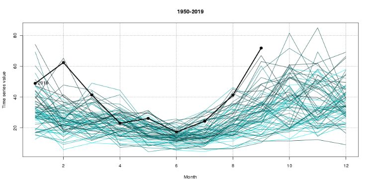
Special Climate Statement 71—severe fire weather southeast Queensland and northeast New South Wales in September 2019

1. Preceding climate conditions

Low rainfall
Fire weather reflects a combination of factors including longer-term rainfall and temperature patterns, and shorter-
term weather on a given day, including temperature, humidity and wind. Fire risk is driven by a number of factors
including fire weather and fuel availability. Rainfall influences the dryness of fuels and is a key factor in calculating
indices for determining fire weather risk such as the Forest Fire Danger Index (FFDI).

Rainfall prior to September 2019 had been below average on a range of timescales from months to years, leading
to a prolonged and severe meteorological and hydrological drought in southern Queensland and northern New
South Wales. Figures 2, 3, and 4 show the rainfall deciles across eastern Australia for January to August, winter,
and August 2019 respectively, with large areas of very much below average rainfall at each timescale.

Rainfall for January to August 2019 was lowest on record in the Southern Downs (Queensland) and Northern
Tablelands (New South Wales). For example, Tenterfield and Stanthorpe were each more than 20% below their
previous record low January–August rainfall (and 77% below the long-term average).

Rainfall in the Gold Coast hinterland had been well below average, but generally not lowest on record for the year-
to-date. In this area, conditions were extremely dry at the start of the year, with rainfall in January and February
below average to locally lowest on record for those months. Rainfall for March to June was generally close to
average, with a return to drier than average conditions in July and August. August was very dry (less than 10 mm
at most sites) but August is a seasonally dry month for the region.

Year-to-date rainfall was generally about 50% below average at sites with at least 40 years rainfall record such as
Mount Tamborine, Wunburra, Springbrook, and the longest-running Gold Coast site (Miami). Those long-term sites
all had one of their ten driest starts to the year: Wunburra (second-lowest); Springbrook (third-lowest); Miami
(fourth-lowest); and Tamborine (eighth-lowest).

At Tewantin on the Sunshine Coast, the year-to-date rainfall total was around 35–40% below average and ninth-
lowest on record. Most of that deficit was in January and February. March to June had near-average rainfall, but
July and August were about 60% below average. Tewantin had only received 6.4 mm in the 30 days before the
start of the fires.

                                                                                                                            7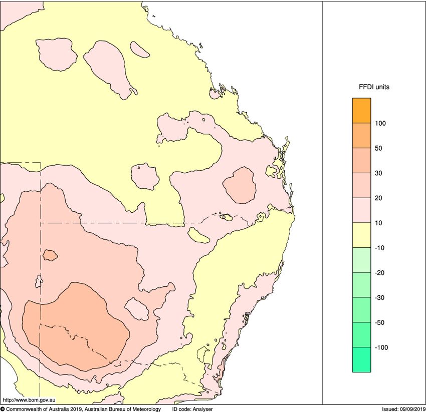
Special Climate Statement 71—severe fire weather southeast Queensland and northeast New South Wales in September 2019

Figure 2: Rainfall deciles map for January to August 2019 (based on all years since 1900).

Figure 3: Rainfall deciles map for winter (June to August) 2019 (based on all years since 1900).

                                                                                                                    8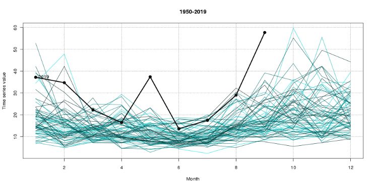
Special Climate Statement 71—severe fire weather southeast Queensland and northeast New South Wales in September 2019

Figure 4: Rainfall deciles map for August 2019 (based on all years since 1900).

                                                                                                                    9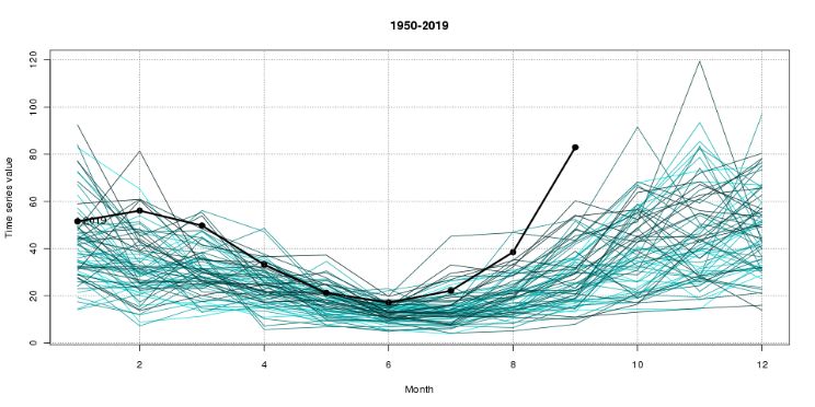
Special Climate Statement 71—severe fire weather southeast Queensland and northeast New South Wales in September 2019

Dry soils
Based on the Australian Water Resources Assessment Landscape model (AWRA-L) 6.0, the modelled root-zone
soil moisture (top 100 cm of the soil profile) was below average to driest on record for the first week of September
2019 over much of southeast Queensland and northeast New South Wales (see Figure 5, based on all years since
1911). The low soil moisture reflected both the recent intense dry conditions, as well as longer-term below average
rainfall stretching back to the start of 2017. Low soil moisture means high stress in the vegetation and will mean
fuels that might not normally burn become available to bushfires.

Figure 5: Mean September root-zone soil moisture deciles for 1–8 September 2019 from the Australian Water
Resources Assessment Landscape model (AWRA-L) 6.0 (based on all years since 1911).

The low rainfall and dry soils meant runoff had also been below average to locally lowest on record across most of
southeast Queensland and northeast New South Wales (see Figure 6). This highlighted that the long
meteorological drought (lack of rainfall) was also reflected in an intense and long-lived hydrological drought
(depleted surface and groundwater storages). These factors set in place the preconditions for dangerous fire
weather.

                                                                                                                   10
Special Climate Statement 71—severe fire weather southeast Queensland and northeast New South Wales in September 2019
Figure 6: Runoff deciles for 8 September 2019 from the Australian Water Resources Assessment Landscape
model (AWRA-L) 6.0 (based on all years since 1911).
The drought factor3, which is an input into the calculation of the FFDI, was above 9 at sites throughout northern
and central Australia, including almost all sites in southeast Queensland and northeast New South Wales. This
means the dryness of fuels was at or near the highest value used for the FFDI calculation.
Very warm year-to-date
In conjunction with the low rainfall, temperatures for 2019 had been consistently warmer than average contributing
to greater rates of drying and higher values of the drought factor.
In 2019, New South Wales had its warmest January to August period on record for overall mean temperature
(1.85 °C above average), and Australia as a whole had its warmest on record such period for maximum (daytime)
temperature (1.71 °C above average) and was second-warmest for mean temperature (1.30 °C above average,
behind 2016).
The high fire dangers in September 2019 included areas of the Murray–Darling Basin. For the Murray–Darling
Basin as a whole, the four overall warmest January to August periods on record since 1910, in order, have been in
2019, 2016, 2018, and 2017. Maximum temperature deciles for the January to August period from 2017 to 2019
are shown in Figure 7, with virtually the whole of the Murray–Darling Basin showing warmest on record. These
high temperatures contribute to higher values of the drought factor and lower values of relative humidity, as well as
directly raise the FFDI, which increases with temperature.
3
The drought factor is a component of the FFDI calculation. It indicated the state of the fuel—how ready it is to burn based on moisture content—and
ranges in value from 0 to 10.
11Special Climate Statement 71—severe fire weather southeast Queensland and northeast New South Wales in September 2019
Figure 7: Map of the Murray–Darling Basin (black outline) showing the mean maximum temperature deciles for the
period January to August in 2017, 2018, and 2019 (based on all years since 1910).
12Special Climate Statement 71—severe fire weather southeast Queensland and northeast New South Wales in September 2019
2. Meteorological drivers
Large-scale climate drivers
Australia's climate was impacted by a positive Indian Ocean Dipole (IOD) in both 2018 and 2019, exerting a drying
influence over many parts of the country. The IOD is characterised by cooler waters to the northwest of Australia
and warmer waters further west towards Africa. The positive IOD contributed to low rainfall over southern and
central Australia during winter4. It is unusual but not unprecedented to have successive positive IOD events (based
on the Bureau of Meteorology's criteria, the last known occurrence of consecutive positive IOD events was in 1982
and 1983). While the IOD is a natural mode of variability, its behaviour is changing in response to climate change.
Research suggests that the frequency of positive IOD events, and particularly the occurrence of consecutive
events will increase as global temperatures rise.
While 2017 was not an official positive IOD, the pattern of ocean temperatures was like that during past IOD
events. In other words, conditions in the Indian Ocean have been unfavourable for rainfall across Australia for each
of the past three years.
In combination with reduced rainfall, positive IOD events also lead to reduced humidity across Australia. Recent
months have seen notably low humidity, which enhances potential evaporation.
A positive IOD is likely to remain the dominant climate driver for Australia until late 2019. IOD events typically
dissipate by early summer as the monsoon trough moves into the southern hemisphere.
In the tropical Pacific Ocean, the El Niño–Southern Oscillation (ENSO) was neutral, having little influence on
Australian and global climate.
Synoptic evolution
On 4 and 5 September, a ridge of high pressure over eastern Australia combined with a dry, stable air mass
resulted in sunny conditions throughout New South Wales and much of Queensland, with warmer than average
maximum temperatures. The high pressure system weakened and drifted northwards over Queensland and by the
6th, extended a ridge along the Queensland coast. On the 6th, a cold front with a pre-frontal trough approached
from the west, bringing strong northwesterly winds ahead of the change (Figure 8).
The strong winds generated areas of raised dust as well as elevated fire dangers through southeast Queensland,
northeast New South Wales, and parts of northern inland New South Wales.
4 More information about the impacts of a positive IOD: http://www.bom.gov.au/climate/iod/#tabs=Positive-IOD-impacts
13Special Climate Statement 71—severe fire weather southeast Queensland and northeast New South Wales in September 2019
Figure 8: Mean sea level pressure analysis maps from 5 September 2019 12:00 UTC to 7 September 2019
00:00 UTC.
3. Temperature
Warmer than average days
This early in the season, the high daytime temperatures in southeast Queensland and northeast New South Wales
on 5 and 6 September 2019 were generally second only to the exceptional winter heat of 23–24 August 20095,
meaning this would have been a record-breaking early season heatwave were it not for 2009. Some locations
surpassed the observed temperatures from August 2009, particularly around Brisbane and further north along the
Queensland coast, and in the Central Western Slopes and Plains of New South Wales where early season heat
records were set.
Figures 9 and 10 show the daily maximum temperature anomalies for 5 and 6 September respectively, with large
areas of northern New South Wales and southern Queensland having daytime temperatures more than 8 °C
warmer than average (based on the 1961–1990 average).
5 See Special Climate Statement 18: Exceptional winter heat over large parts of Australia
14Special Climate Statement 71—severe fire weather southeast Queensland and northeast New South Wales in September 2019
Figure 9: Daily maximum temperature anomalies for 5 September 2019 (based on the 1961–1990 average).
Figure 10: Daily maximum temperature anomalies for 6 September 2019 (based on the 1961–1990 average).
15Special Climate Statement 71—severe fire weather southeast Queensland and northeast New South Wales in September 2019
Low humidity
Dewpoint temperatures were very low at sites in southeast Queensland and northeast New South Wales. Most
dewpoint temperatures were in the –8 °C to –12 °C range, although Brisbane Airport got down to –12.7 °C. These
dewpoint temperatures were below average, but well short of September records. The Brisbane Airport value has
historically been about a 1-in-10 year event for September, and at Oakey in the Darling Downs a 1-in-2 to -3 year
event.
Vapour pressure (an indication of humidity)6 was below average throughout the day on the 6th (Figure 11). Both
the 9am and 3pm vapour pressure observations showed large areas more than 6 hPa below average in southeast
Queensland and northeast New South Wales, indicating in intensely dry air mass.
Figure 11: 3pm vapour pressure anomalies on 6 September 2019 (based on the 1961–1990 average).
6 For more information about vapour pressure see http://www.bom.gov.au/climate/austmaps/about-vprp-maps.shtml
16Special Climate Statement 71—severe fire weather southeast Queensland and northeast New South Wales in September 2019
Precipitable water provides an estimate of the amount of moisture in the atmosphere7. During the first week of
September 2019, precipitable water values were consistently below average at Brisbane Airport, Moree, and
Charleville. On the 6th and 7th, precipitable water values also dropped below average at sites further south, such
as Sydney Airport and Williamtown RAAF.
4. Strong winds
Strong winds were observed over large areas of eastern New South Wales and southeast Queensland on the 6th.
Numerous sites in New South Wales and southeast Queensland recorded maximum wind gusts of more than
80 km/h (see Figure 12).
Several sites in eastern New South Wales recorded their highest maximum wind gust in September for at least 10
years. The strong winds extended north into southeast Queensland, with Applethorpe recording its strongest
maximum wind gust in September for more than 10 years (see Figure 13).
Figure 12: Map showing sites that had a maximum wind gust of more than 80 km/h on 6 September 2019. The
white outlines indicate sites with 10 or more years of wind data that set a September record.
7
Precipitable water is the total water vapour contained in an atmospheric column of unit cross-section, expressed in terms of the depth of an equivalent
mass of liquid water of the same cross-section. Further information available at http://www.bom.gov.au/climate/updates/articles/a024.shtml.
17Special Climate Statement 71—severe fire weather southeast Queensland and northeast New South Wales in September 2019
Figure 13: Map showing sites with 10 or more years of wind gust data that had their highest September maximum
wind gust on record on 6 September 2019. The white outlines indicate sites that had their strongest wind gust for
any month.
18Special Climate Statement 71—severe fire weather southeast Queensland and northeast New South Wales in September 2019
5. Fire weather
In coastal areas of southeast Queensland and northeast New South Wales, September has historically had the
highest FFDI values of the year. Further inland, the highest FFDI values are typically later in the season, with most
areas west of the ranges in New South Wales not having their peak fire weather until January (see Figure 14).
Figure 14: Map of eastern Australia showing the month of the highest climatological mean daily FFDI, using the
base period 1989–2018.
The high fire dangers during this event followed on from very much above average accumulated FFDI values
during winter 2019 over Australia. The only areas of the country that had average to below average accumulated
FFDI values for winter (FFDI values summed across the season) were those areas of southern and western
Victoria, western Tasmania, and northern inland Queensland that had average to the above average rainfall during
the season (see Figure 15).
19Special Climate Statement 71—severe fire weather southeast Queensland and northeast New South Wales in September 2019
Figure 15: Accumulated FFDI deciles for winter (June to August) 2019, based on all years since from 1950.
In August 2019, the Bushfire and Natural Hazards Cooperative Research Centre (BNHCRC)8 issued the Australia
Seasonal Bushfire Outlook: August 2019, reporting that northeast New South Wales and southeast Queensland
were among those areas of Australia that faced above normal fire potential for the 2019–20 fire season.
From 6 September, high temperatures, low humidity, and strong winds, coupled with the dry conditions, led to
elevated fire danger across southeast Queensland and northeast New South Wales. The measured FFDI values
were in the extreme category (over 75) across large areas, reaching the catastrophic category (FFDI values of 100
or above) at some locations in New South Wales.
Figure 16 shows the location of sites with at least 10 years of data that had their highest FFDI in September on
6 September 2019, or highest so early in the season for at least 10 years. Figure 17 shows the areas of highest
FFDI in September based on the daily gridded FFDI dataset (see Dowdy, 2018), which extends back to 1950.
8 http://www.bnhcrc.com.au/
20Special Climate Statement 71—severe fire weather southeast Queensland and northeast New South Wales in September 2019
Figure 16: Map of eastern Australia for 6 September 2019 showing sites that had their highest daily FFDI in
September for at least 10 years (white outline) or the highest so early in the season for at least 10 years (white
dashed outline).
Figure 17: Highest daily FFDI values on 6 September 2019 compared with the previous highest September daily
FFDI (1950–2018). Shaded areas indicate places where it was the highest FFDI on record for September.
21Special Climate Statement 71—severe fire weather southeast Queensland and northeast New South Wales in September 2019
In most districts of northeast New South Wales, 6 September 2019 had the highest regionally averaged daily FFDI
in September, based on all years since 1950 (see Figure 18). East of the ranges though, the daily averaged FFDI
for the North Coast was the third-highest in September, behind 27 September 1994 and 14 September 2017. For
each of the first eight months of 2019, the highest regionally averaged daily FFDI was above average in all
regions.
(a) (b)
(c) (d)
Figure 18: Regionally averaged highest daily FFDI for each month from 1950 to 2019, with 2019 shown by the
black line. Values for 1950 to 2018 are shown in shades of green, with the most recent years a darker shade.
Graphs shown for the following districts of northern New South Wales: (a) Northwest Plains; (b) Northwest Slopes;
(c) Northern Tablelands; (d) North Coast district.
22Special Climate Statement 71—severe fire weather southeast Queensland and northeast New South Wales in September 2019
In southeast Queensland on 6 September 2019, the Darling Downs9 had its highest regionally averaged daily FFDI
on record for September, based on all years since 1950 (see Figure 19). Closer to the coast, the Moreton district
(including Brisbane) had its second-highest September FFDI value on record, behind 27 September 1994. North of
Brisbane, the Port Curtis district had its third-highest regionally averaged daily FFDI value on record for
September, behind both 27 September 1994 and 22 September 1969, the latter being a day when FFDI values
reached the extreme category in areas around Biloela. We note that in most of those regions where the FFDI was
not a September record, it was an early season record (i.e. the highest value so early in spring in most areas).
(a) (b)
(c) (d)
Figure 19: Regionally averaged highest daily FFDI for each month from 1950 to 2019, with 2019 shown by the
black line. Values for 1950 to 2018 are shown in shades of green, with the most recent years a darker shade.
Graphs shown for the following districts of southeast Queensland: (a) Maranoa and Warrego; (b) Darling Downs;
(c) Moreton; (d) Port Curtis
9 Boundaries of districts referred to in this section can be found at http://www.bom.gov.au/climate/cdo/metadata/maps/raindist.pdf
23Special Climate Statement 71—severe fire weather southeast Queensland and northeast New South Wales in September 2019
Regionally, the FFDI conditions were slightly more unusual for this time of the year in northeast New South Wales
than southeast Queensland. An average over a large region is more robust and can better show the unusual
nature of conditions.
In northeast New South Wales, 6 September 2019 was the highest September daily FFDI averaged over the
combined districts of the Northern Tablelands, Northwest Slopes, and Northwest Plains on record, based on all
years since 1950 (Figure 20).
Figure 20: Regionally averaged highest September daily FFDI (1950–2019) across the combined Northern
Tablelands, Northwest Slopes, and Northwest Plains districts of New South Wales, with a lowess regression
superimposed (span parameter f = 0.8). The 2019 value is based on the highest averaged daily FFDI from 1 to
6 September.
24Special Climate Statement 71—severe fire weather southeast Queensland and northeast New South Wales in September 2019
6. Documented impacts of the conditions
Queensland
On 5 September, one home was lost in northern Queensland near Mareeba in the Atherton Tablelands. Properties
were destroyed overnight on 6 September at Binna Burra and near Stanthorpe. By 7 September, more than 50
fires were burning across Queensland and this had increased to 80 by 9 September. Residents were evacuated
from parts of Beechmont and Binna Burra in the Gold Coast hinterland, and Stanthorpe and Applethorpe in the
Granite Belt.
By 11 September, there were 70 fires still burning across Queensland, and Queensland Fire and Emergency
Services (QFES) confirmed there had been 17 homes lost across the region. Bushfires had scorched more than
33 000 hectares statewide, including 10 600 hectares at Hawkwood; 5 000 hectares at Sarabah; 2 000 hectares at
Stanthorpe, and almost 1 000 hectares at Peregian Springs.
Details:
• On 2 September, a fire was burning in difficult terrain in Sarabah, southwest of Canungra in the Gold
Coast hinterland, with people in Sarabah, Tamborine Mountain and Canungra affected by smoke. The fire
continued for several days, then strong and dry west to northwesterly winds on Friday the 6th caused it to
spread to Binna Burra, in mountainous terrain south of Canungra through the Lamington National Park. By
7 September, the fire stretched from Canungra to Binna Burra and was about 10 km long and 5 to 10 km
wide, moving at a pace of around 2 km/h. The Binna Burra Lodge was engulfed on the morning of
8 September and fire caused extensive damage to the property. Fires near Sarabah were still active on the
10th, affecting Binna Burra, Canungra and Beechmont, where more than 3 600 hectares had burnt. Over
130 people and 47 vehicles were evacuated from O’Reilly overnight on the 9th, passing through a fire
zone with Queensland Police helicopter (POLAIR) aerial support.
• From the 6th, fires took hold around Stanthorpe and Applethorpe, with homes destroyed overnight on the
6th. Fires were still burning on the 10th near Stanthorpe, including near Applethorpe and Amiens, where
2 000 hectares had burnt.
• Late on the 9th, a fast-moving fire at Peregian Beach in the Sunshine Coast was travelling in an east-
northeast direction from Emu Mountain Road towards Pitta Street and Lorikeet Drive, and was heading
towards Coolum State High School on Havan Road East. Peregian Beach residents were asked to
evacuate either south towards Coolum or north towards Noosa. By 8pm, the fire was still travelling east-
northeast towards Peregian Beach and Marcus Beach. Overnight on the 9th, at least one home was
destroyed at Peregian Beach. A southerly wind change around midday on the 10th caused the fire to
spread northwards, but the moist sea-breeze assisted with retarding the movement of the fire. By 11
September, the fire was under control, and residents returned to their homes.
New South Wales
By 9 September, more than 50 fires were active in New South Wales and by the morning of the 10th, several
homes had been destroyed. On the morning of 9 September, five fires were burning out of control and three watch
and act alerts were in place for blazes at Drake near Tenterfield, Ebor near Armidale, and Shark Creek in the
Clarence Valley.
25Special Climate Statement 71—severe fire weather southeast Queensland and northeast New South Wales in September 2019
Details:
• By 9 September, several fires were burning in the Tenterfield Local Government Area (LGA), the largest of
which was the Long Gully Road fire at Drake. The fire had burnt more than 32 100 hectares and was out of
control, burning in bushland south of the Bruxner Highway and south of Drake and Tabulum, to the west of
Clarence River in the Girard State Forest. It was burning in a northeasterly direction towards the villages of
Drake and Tabulum. By the morning of 10 September, more than 40 000 hectares had burnt. In the
afternoon, the fire breached containment lines and spread towards the Sandy Creek and Sandy Hill areas,
and continued to burn to the west of Clarence River in the Girard State Forest. By 15 September, 53 200
hectares had been burnt.
• On 9 September, the Armidale fire at Bees Nest was burning north of Ebor and to the northwest of Dorrigo.
The fire already covered more than 61 300 hectares and had a perimeter of more than 100 km. Up to
66 500 hectares had been burnt on multiple fronts by 10 September, and more than 90 100 hectares had
been burnt by the 15th.
• On the morning of 9 September, a fire at Shark Creek in the Clarence Valley LGA was burning out of
control, with more than 3 700 hectares burnt. The fire was burning in a northeasterly direction and crossed
Brooms Head Road. By midday, the fire was burning in bushland in the Yuraygir National Park and Shark
Creek area, south of Yamba, and more than 5 000 hectares had been burnt. In the afternoon, a southerly
wind change pushed the fire towards Yamba and later in the evening the fire was burning on the north and
south of Angourie and Wooleweyah. By 12 September, more than 10 100 hectares had been burnt
Figure 21: Map of eastern Australia showing the locations of some of the most significant fires (red triangles).
There were more than 50 fires reported in Queensland and another 50 in New South Wales in the week after
6 September 2019.
26Special Climate Statement 71—severe fire weather southeast Queensland and northeast New South Wales in September 2019
7. Historical and future trends
While all exceptional climate events have proximate (local) causes in antecedent and concurrent weather
conditions, long-term trends and slow variations also play a role.
As with surface air temperature, Australia has seen rising trends in fire danger indices in recent decades (see
Dowdy, 2018)10. In particular, the annual accumulated FFDI (a sum of FFDI across the year) has been increasing
across most of eastern Australia, including southeast Queensland and some areas of northeast New South Wales.
The trend in accumulated FFDI captures both an increase in the frequency and severity of dangerous fire weather
conditions. Figure 22 shows the change in highest daily FFDI for September from 1950 to 2018, with the largest
increases in southeast Queensland, and western and southern coastal areas of New South Wales
Figure 22: Map of eastern Australia showing the change in the highest daily FFDI for September from 1950 to
2018.
A measure of the onset of the fire season in a region is given by the first day when the FFDI passes 35 (other
thresholds show similar outcomes). In the Northwest Slopes and Plains districts of New South Wales, the first day
10 See also State of the Climate 2018.
27Special Climate Statement 71—severe fire weather southeast Queensland and northeast New South Wales in September 2019
has come forward by about a month since 1950, while noting a considerable degree of interannual variability (see
Figure 23). In this context, both the very high FFDI values and their occurrence early in the season is consistent
with the trend in these measures.
Figure 23: Date of the first day of each year after 31 May when FFDI values exceeded 35 in the Northwest Slopes
and Plains districts (rainfall districts 52–55) of New South Wales. A lowess regression with span parameter f = 0.8
has been superimposed. Smaller values indicate an earlier start to the fire season.
Model projections into the future continue to show an increase in FFDI values due to increasing greenhouse
emissions over the course of the century, including throughout the areas where the September 2019 fires
occurred. This is a robust result across a range of different methods and metrics (for details see Figure 6 of Dowdy
et. al. 2019).
28Special Climate Statement 71—severe fire weather southeast Queensland and northeast New South Wales in September 2019
8. Previous notable events
Spring is the peak of the fire weather season in much of southeast Queensland and northeast New South Wales.
When antecedent conditions are dry, September days with strong winds and warm temperatures can result in
severe fire weather.
September 1991
August and September 1991 were exceptionally dry months in Queensland, at the peak of a significant drought
that affected much of southeast Queensland over the preceding year.
Severe fire weather was a regular feature of September 1991 in southeast Queensland; there were major fires on
the 1st, 10th, 14–15th, 19th–22nd, and 29th. In the second half of the month, this extended to eastern New South
Wales. The events of the 10th and 14–15th in particular were associated with high temperatures and gusty winds.
There was one loss of life associated with the fires in the Sunshine Coast hinterland.
This proved to be the drought's peak in the southeast of the State, with average to above-average rainfall returning
from October onwards, although dry conditions persisted through the summer in northern Queensland and in the
tropics more generally.
Figure 24 shows large areas of southeast Queensland and northern New South Wales with very much above
average monthly accumulated FFDI values for September 1991.
Figure 24: Accumulated FFDI deciles for September 1991 (based on all years since 1950).
29Special Climate Statement 71—severe fire weather southeast Queensland and northeast New South Wales in September 2019
Spring 1994
There were numerous fires in southeast Queensland during the final week of September 1994, with property
losses near Toowoomba and in the Gold Coast hinterland. Further fires in early November caused some property
loss and extensive damage to commercial forests around Beerburrum.
April to September 1994 was extremely dry through southeast Queensland and in eastern Australia more
generally, with rainfall for the period at or near record-low levels in many inland regions. October rainfall was
generally close to average. The worst fire weather days in late September and in early November also saw strong
winds; in particular, the strong winds in early November were associated with an intense low pressure system near
Tasmania that also caused widespread wind damage in southeast Australia.
In coastal areas, 27 September 1994 had the highest regionally averaged September daily FFDI for the North
Coast district of New South Wales and Moreton district of Queensland since at least 1950.
October 2002
In late October 2002, fires in southeast Queensland burnt 40 000 ha, with one reported death, and 10 houses, 11
buildings, and 30 structures destroyed or damaged in the Stanthorpe district, Toowoomba Range and Tara. This is
the fire event that is most directly comparable with the 2019 event in the Southern Downs Region.
2002 was a consistently dry year, with many areas of southern Queensland having January to September rainfall
40 to 60% below average. The weeks leading up to the fires were especially dry in the Southern Downs, with less
than 20 mm falling at most locations between 1 September and 27 October. Temperatures were also well above
average, particularly on the 19th and 26th, when it reached 33.0 °C at Applethorpe11, an October record, which
was subsequently broken in 2014.
September 2017
The earliest in the season that extreme category FFDI values (FFDI > 75) have been recorded in northern New
South Wales was 3 September 2017. The highest values on the day were in the Central Western Plains district,
with extreme FFDI values at Coonamble and Trangie.
Prior to September 2019, the highest FFDI values on record in southern Queensland west of the ranges were on
23 September 2017, with FFDI values on the day reaching the catastrophic category (FFDI > 100) at numerous
sites in southwest Queensland, including Thargomindah, and western New South Wales, including Cobar,
Coonamble, and Broken Hill.
September 2018
Prior to September 2019, the most recent occurrence of an FFDI value in the extreme category (FFDI > 75) in
September in northern New South Wales was at Walgett on 15 September 2018. The day also had extreme
category FFDI values at places such as Wollongong and Bega in the Illawarra and South Coast districts of New
South Wales.
11 There were no temperature observations at Stanthorpe in October 2002.
30Special Climate Statement 71—severe fire weather southeast Queensland and northeast New South Wales in September 2019
Tables
Table 1: January–August 2019 rainfall totals at selected locations in southeast Queensland and the New South
Wales Northern Tablelands district.
Jan – Aug 2019 Rank (if in Existing record
Site number(s) Location % below average
total (mm) lowest 10) (mm)
Northern Tablelands
56002/56037 Armidale 193.0 –60 1 207.3 (1874)
56011/56243 Glen Innes 238.8 –57 1 243.6 (1922)
56032 Tenterfield 138.6 –77 1 190.4 (1888)
Southern Downs/Granite Belt
41095 Stanthorpe 136.7 –77 1 180.0 (1902)
41111/41525 Warwick 156.6 –65 1 168.0 (1902)
41103/41529 Toowoomba 281.4 –56 6 167.9 (1902)
Scenic Rim region
40094 Harrisville 185.6 –67 3 115.7 (1902)
40490 Carneys Creek 239.6 –66 1 334.0 (2005)
Gold Coast hinterland
40197 Mt Tamborine 581.6 –53 8 438.4 (1932)
40534 Wunburra 529.1 –56 2 329.9 (1986)
Springbrook
40607 883.9 –47 3 559.6 (1986)
Road
Gold Coast
40490 Miami 559.6 –48 4 421.0 (1986)
31Special Climate Statement 71—severe fire weather southeast Queensland and northeast New South Wales in September 2019
Table 2: Sites that had a maximum wind gust > 80 km/h on 6 September 2019.
Station Max wind gust Point direction of
number Station name State (km/h) max wind gust
68242 Kiama (Bombo Headland) NSW 115 WSW
61392 Murrurundi Gap AWS NSW 111 NW
68228 Bellambi AWS NSW 111 WNW
68253 Port Kembla NTC AWS NSW 109 W
69017 Montague Island Lighthouse NSW 107 W
68241 Albion Park (Wollongong Airport) NSW 106 W
66037 Sydney Airport AMO NSW 102 WSW
66196 Sydney Harbour (Wedding Cake West) NSW 100 WSW
67113 Penrith Lakes AWS NSW 100 NW
67108 Badgerys Creek AWS NSW 96 NNW
61363 Scone Airport AWS NSW 94 W
61425 Gosford AWS NSW 94 W
66043 Kurnell AWS NSW 94 W
67105 Richmond RAAF NSW 93 WNW
61055 Newcastle Nobbys Signal Station AWS NSW 91 W
66022 Fort Denison NSW 91 W
63292 Mount Boyce AWS NSW 89 WSW
68072 Nowra RAN Air Station AWS NSW 89 WNW
61078 Williamtown RAAF NSW 87 WNW
61250 Paterson (Tocal AWS) NSW 87 WNW
61430 Singleton Defence AWS NSW 87 NW
71032 Thredbo AWS NSW 87 NW
54038 Narrabri Airport AWS NSW 85 NW
66137 Bankstown Airport AWS NSW 85 WSW
66161 Holsworthy Aerodrome AWS NSW 85 WSW
66208 Wattamolla AWS NSW 85 W
41359 Oakey Aero QLD 83 WNW
47048 Broken Hill Airport AWS NSW 83 WSW
53115 Moree Aero NSW 83 WSW
56238 Armidale Airport AWS NSW 83 NW
68192 Camden Airport AWS NSW 83 NNW
68239 Moss Vale AWS NSW 83 NNW
51161 Coonamble Airport AWS NSW 81 WNW
56243 Glen Innes Airport AWS NSW 81 WNW
66194 Canterbury Racecourse AWS NSW 81 WSW
75019 Hay Airport AWS NSW 81 WNW
32Special Climate Statement 71—severe fire weather southeast Queensland and northeast New South Wales in September 2019
Table 3: Sites with more than 30 years of data that set new or equalled early season records for maximum temperature on 6 September 2019.
New early Previous highest
Station Years of season temperature this Date of previous Earliest higher Date of higher
number Station name State data record (°C) early (°C) highest temperature temperature (°C) temperature
39123 Gladstone Radar QLD 61 33.0 31.6 2009-08-30 33.8 2013-09-11
39128 Bundaberg Aero QLD 41 32.4 31.1 2009-08-30 32.4 2003-09-12
40004 Amberley AMO QLD 78 36.4 36.4 2009-08-24 39.2 1943-09-22
Double Island
40068 Point Lighthouse QLD 59 30.9 28.2 2009-08-24 31.4 2003-09-12
Quirindi Post
55049 Office NSW 54 31.2 29.3 1982-09-02 31.4 2017-09-13
56229 Guyra Hospital NSW 38 25.4 25.2 2009-08-24 25.4 2017-09-23
Yarras (Mount
60085 Seaview) NSW 50 34.1 34.1 2009-08-24 35.3 2003-09-22
Murrurundi
61051 (Haydon Street) NSW 53 30.4 27.3 1995-08-22 30.4 2017-09-13
Williamtown
61078 RAAF NSW 69 31.2 30.5 2012-08-23 31.7 1980-09-08
Paterson (Tocal
61250 AWS) NSW 49 32.3 30.7 2017-09-03 32.4 1980-09-08
Dunedoo Post
64009 Office NSW 54 31.2 29.5 1982-09-02 32.3 2003-09-22
33Special Climate Statement 71—severe fire weather southeast Queensland and northeast New South Wales in September 2019
Table 4: Sites that recorded a maximum FFDI ≥ 75 (extreme category) on 6 September 2019.
Station number Station name District State Maximum FFDI
40004 Amberley AMO Moreton QLD 86
40082 University of Queensland Gatton Moreton QLD 78
40211 Archerfield Airport Moreton QLD 81
40842 Brisbane Aero Moreton QLD 78
41359 Oakey Aero Darling Downs QLD 87
41522 Dalby Airport Darling Downs QLD 91
43091 Roma Airport Maranoa QLD 75
43109 St George Airport Maranoa QLD 84
44021 Charleville Aero Warrego QLD 77
51161 Coonamble Airport AWS Central Western Plains NSW 104
52088 Walgett Airport AWS Northwest Plains NSW 106
53115 Moree Aero Northwest Plains NSW 109
54038 Narrabri Airport AWS Northwest Slopes NSW 111
55202 Gunnedah Airport AWS Northwest Slopes NSW 99
55325 Tamworth Airport AWS Northwest Slopes NSW 127
56238 Armidale Airport AWS Northern Tablelands NSW 75
60141 Taree Airport AWS Manning NSW 76
61287 Merriwa (Roscommon) Hunter NSW 92
61363 Scone Airport AWS Hunter NSW 95
61392 Murrurundi Gap AWS Hunter NSW 174
62101 Mudgee Airport AWS Central Tablelands NSW 90
64017 Coonabarabran Airport AWS Central Western Slopes NSW 87
67105 Richmond RAAF Metropolitan NSW 109
67108 Badgerys Creek AWS Metropolitan NSW 90
67113 Penrith Lakes AWS Metropolitan NSW 89
68192 Camden Airport AWS Metropolitan NSW 92
34Special Climate Statement 71—severe fire weather southeast Queensland and northeast New South Wales in September 2019
References and further information
National gridded rainfall analyses are for the period since 1900 and national gridded temperature analyses are for
the period since 1910. Gridded FFDI analyses are for the period since 1950.
This Statement in general covers information available as of 12 September 2019.
Links to further information
Australia's changing climate:
State of the Climate 2018
Climate information:
http://www.bom.gov.au/climate/
Australian Landscape Water Balance:
http://www.bom.gov.au/water/landscape
References
Dowdy, A.J., 2018: Climatological Variability of Fire Weather in Australia. Journal of Applied Meteorology and
Climatology, 57, 221–234. https://journals.ametsoc.org/doi/full/10.1175/JAMC-D-17-0167.1
Dowdy, A.J., Ye, H., Pepler, A., Thatcher, M., Osbrough, S.L., Evans, J.P., Di Virgilio, G., McCarthy, N., 2019:
Future changes in extreme weather and pyroconvection risk factors for Australian wildfires. Scientific Reports, 9,
2045-2322. https://www.nature.com/articles/s41598-019-46362-x.pdf
35You can also read