ST ALDHELM'S WAY - Centre for Christian Pilgrimage
←
→
Page content transcription
If your browser does not render page correctly, please read the page content below
ST ALDHELM'S WAY
AN ANGLO-SAXON PILGRIMAGE FROM DOULTING TO MALMESBURY

                  ST ALDHELM'S LAST JOURNEY

                     ST. ALDHELM c640AD-709

(The Digby Memorial of the 1st Saint of Wessex at Shaftesbury Abbey)
                  Compiled by Rev'd. Chris and Miriam Hare

                 The pilgrimage was walked in 2019 and 2020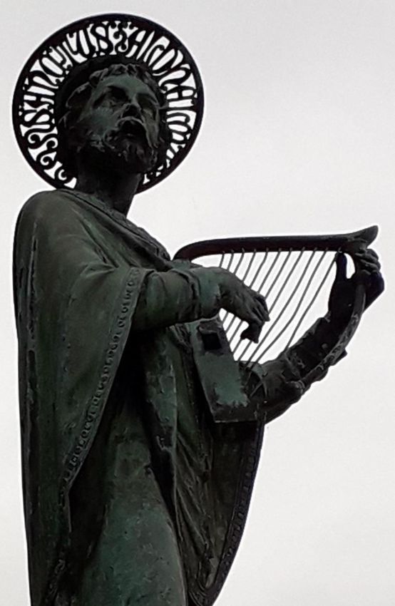
AN INTRODUCTION TO CHRISTIANITY AND TO THE ANGLO SAXONS

Christianity was first practised in Britain towards the end of the second century, and was mostly based in
towns where paganism was also practised. Germanic tribes started to settle in Romano-Celtic Britain in the
middle of the fifth century. The Angles came from modern Denmark, the Saxons from modern northern
Germany and the Jutes from the coast of Germany and Holland. Saxons conquered South West England in
the sixth century and formed the kingdom of the West Saxns. They were pagans and Christianity had nearly
died out.

In 596AD Pope Gregory sent a mission led by Augustine to “ preach the word of God to the English race".
They arrived in Thanet in Kent in 597AD. King Aethelberht of Kent's wife was already a Christian, and he was
converted and then baptised. Soon after 10,000 converts were baptised on Christmas Day in 597AD, and
many others followed. Old churches were restored and new ones were built. Roman Christianity had come to
England.

Then Pope Gregory’s successor, Honorius, sent another mission with Bishop Birinus to England in 634AD
again to preach the gospel. He landed in Wessex, baptised the king of the West Saxons, Cynegils, and then
many of the population of Wessex.

ALDHELM

Aldhelm is believed to have been born in AD640 and was part of the ruling family of the West Saxons who
occupied south west Britain, including the counties of Somerset and Wiltshire. He was born into a Saxon
world which had only recently become Christian. He is thought to have received his education, from the age
of fifteen, at Malmesbury from an Irish ascetic and hermit monk called Maildulph, after whom the town is
named. From there he went on to Canterbury to continue his education at a time when it was an educational
establishment of great excellence.

Aldhelm was said to be very tall, cheerful, friendly and good natured by character. He returned to Malmesbury
in 676AD and founded the monastery there observing the Benedictine rule, it lasted for more than 850 years.
He also founded monasteries at Frome, and Bradford- on- Avon, and was Abbot at both. He also built many
local churches. His ministry spread to most of Wiltshire, Somerset and Dorset. Aldhelm was the founder and
first Abbot of Malmesbury monastery.

Aldhelm was a talented man. He was known as the most learned western scholar of the latter part of the 7th
century. He spoke Latin and Greek fluently. He played the harp, fiddle and pipe. He used music to draw
crowds and would then preach to them. He would go to Malmesbury town bridge and make connections with
the local community there. In the ninth century King Alfred the Great said “Aldhelm won men to heed sacred
things by taking his stand as a gleeman and singing English songs on a bridge." And he was credited both in
his life, and after his death, with many miracles. He was a poet, teacher, evangelist, writer of riddles, author,
letter writer, composer, and moralist and had the finest intellect of his age. He translated the Psalms into
Anglo Saxon in the ninth century. He was praised by Bede of Jarrow for his holiness and talents.

In 700/701AD Aldhelm made a pilgrimage to Rome and visited Pope Sergius, who was so impressed with
Aldhelm that he issued a Papal Bull declaring that the three monasteries of which Aldhelm was in charge
were to be under his sole authority, thus bypassing the diocesan bishop.

The diocese of Sherborne was enlarged in 705AD to include Somerset, Dorset, Devon and Cornwall and
Aldhelm became it’s first Bishop (it later became the Diocese of Salisbury, after the Norman Conquest).

Aldhelm died on May 25 709AD in Doulting near Shelton Mallet in Somerset. The story goes that shortly after
dying, he appeared in a vision to his friend, Ecquin the Bishop of Worcester and Abbot of Evesham telling him
of his own death and commanding him to come to Doulting. The Bishop came, and at once made
arrangements for Aldhelm's body to be carried to Malmesbury.

The funeral procession brought Aldhelm’s body from Doulting to Malmesbury to be buried there by Ecquin.
The historian William of Malmesbury (1095-1143) tells us that stone crosses were later erected at 7 mile
intervals along the route, at points where his body had rested. (Later King Edward 1 would set up Eleanor
crosses at each place where the Queen Eleanor's body had rested on its way from Lincoln to Westminster.)
The final cross for Aldhelm was in the cloisters of the monastery at Malmesbury. It was there Aldhelm was
buried in the church dedicated to Saint Michael in a tomb that had supposedly been prepared in advance for
this occasion. William of Malmesbury also tells that all of the seven crosses were still there in his day, four
centuries later. He claimed that many who were ill went up to the crosses and were healed. After Aldhelm's
death he was venerated as a saint, his feast day being the day of his death, May 25.
Various suggestions have been made as to the route that the funeral procession might have taken from
Doulting to Malmesbury, but we have followed the route suggested by Bishop Browne, the Bishop of Bristol,
who wrote a book on the life of Aldhelm in 1903. Sadly, nearly all traces of the stone crosses have now
disappeared, a few probable fragments remain.
THE PILGRIMAGE
This pilgrimage starts at St Aldhelm's church, Doulting near Shepton Mallet where Aldhelm died in 709 and
ends after approximately 53 miles at Malmesbury Abbey.
St Aldhelm’s Way weaves its way through:
3 counties: Somerset, Wiltshire and Gloucestershire, and
3 dioceses: Bath and Wells, Salisbury and Gloucester.
At each "resting place" we have included some relevant history of each place or church and a list of local or
nearby facilities.
We advise you to check the points of information at the back, before you set off.
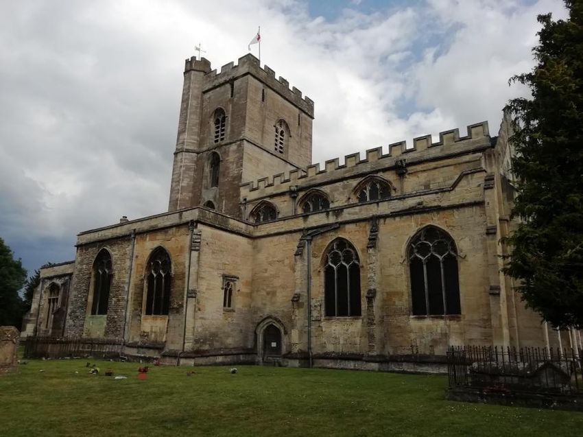
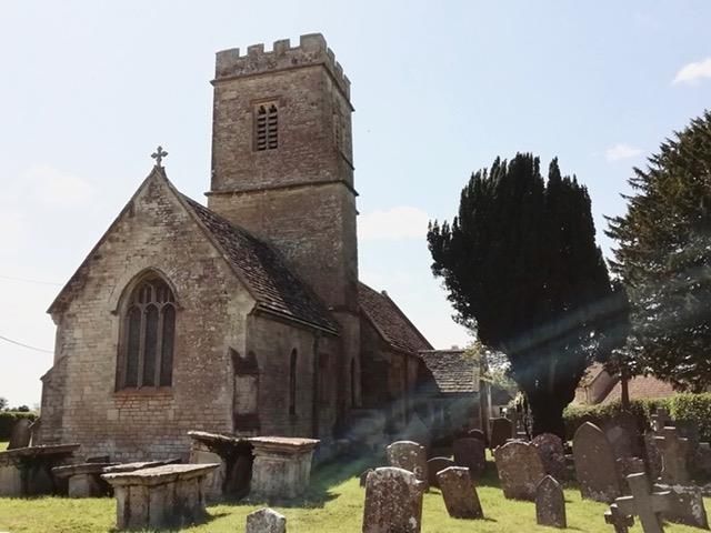
ST. ALDHELM’S CHURCH, DOULTING
SOME HISTORY ABOUT DOULTING
Doulting Church is Grade one listed and received its dedication to St Aldhelm in the 8th century when King
Ine gave the local estate to Glastonbury Abbey, named after his relative Aldhelm, who had died here in
709AD. At the time of Aldhelm’s death it would have been a small wooden church. The local school is also
named after Aldhelm.
In the centre of Doulting village, at the crossroads, are some interesting estate cottages and south of the
crossroads is Manor Farm and its noble 13th century Tithe Barn.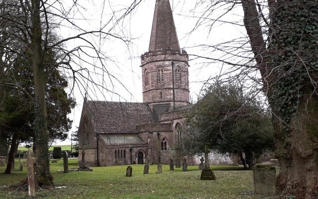
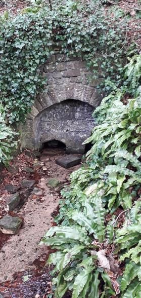
FACILITIES nearby

Poachers Pocket Pub at Chelynch

The Waggon and Horses at Beacon Hill

Charlton House Hotel, Shepton Mallet

Little Thatch Restaurant, Shepton Mallet

DAY ONE

DOULTING TO FROME - approx 9 miles

God speed as you walk this pilgrimage along St Aldhelm’s Way.

We prayed this each day as we set off:

A PILGRIMAGE PRAYER
O Lord God, from whom we come,
in whom we are enfolded,
to whom we shall return.
Bless us in our pilgrimage through life,
with the power of the Father protecting,
with the love of Jesus indwelling,
and the light of the Spirit guiding,
until we come to our ending
in life and love eternal.
Amen.                        Written by Rt. Rev'd. Peter Knott (former Bishop of Taunton)

On the north side of the churchyard, cross the lane and take the footpath
opposite following the sign to the Holy Well.
Go through a gate on to a lane and turn left down the hill past the Old Bell
House on your right.
St Aldhelm's Well (pictured here) is on your left after about 50 metres.
It is behind an outer wall with a trough, the water rising from two openings in a
second wall. It may have been constructed as a bath for pilgrims.
Water rises from a spring and flows from a channel into a trough beside the
lane into the River Sheppey.
As Aldhelm was dying he was given water from this well and it was was later
supposed to have healing powers. The Spring became a pilgrimage site and
was renowned for curing eye ailments.

Just after the well take the footpath bearing right to Bodden Cross Lane, walk
up the steps and through the gate into a field.
Take the footpath aiming at one o'clock up the slope.
Go over the stile nearly to the left corner of the field.
Walk along with the hedge on your left, when the field opens up to the left,
carry on across the field at 11 o'clock towards the trees on the horizon.
When you arrive at the trees this is where you join the EAST MENDIP WAY,
which we will follow to the outskirts of Frome.
Turn right through the kissing gate and walk through the field.
Clamber over some stones into the next field keeping the hedge on your right, walk through a kissing gate
then keep straight on with the spinney on your right.
Go through the kissing gate and onto the road.
Turn right onto the road and walk into Chelynch village.
Turn left in the village and walk past the Poachers Pocket Pub.
Take a left turn after the pub.
After 200 yards along the road, turn right up some steps through the hedge, this is quite hidden, and then
cross the field at 11 o'clock towards the right of four trees at the far edge of the field.
Go over the stone stile, and take the footpath at 10 o'clock across the field.
Go through a break in the hedge into the next field.
Walk straight on keeping the hedge to your right.
After 300 yards bear right when you see Newmans Street Farm on your right, walk through the kissing gate,
cross a small paddock, keeping the hedge on your left, walk through the kissing gate and onto the road.

Turn right onto the road.
After 100 yards turn left through a kissing gate and walk over the field at 12 o'clock.
Walk through two kissing gates and straight across the field through two stiles, through a paddock, and a
kissing gate, and walk across another paddock at 10 o'clock, passing Temple House Farm on your left.
Cross a stone stile onto the road and turn left onto the road.
After 20 yards turn right onto a road and walk along it for 400 yards.
This leads to the main road at Waterlip.
Cross the main road at the Primitive Methodist chapel built in 1874 and take the footpath opposite, and over
the stile.

After 50 yards just before a gate, turn right up the slope, through a kissing gate, and across the field.
Go through the gate and across the field at 2 o clock.
Go through another gate and across another field at 2 o clock into a wood.
Walk through a kissing gate and through the wood following the path, and through another kissing gate, follow
the path and through another kissing gate into Funtles Lane.
Turn right along the lane, through the gate and straight across the field.
Through another gate, across the field, through another gate and across a field keeping the hedge to your
right.
Go through a gate into a wood, turn right and after 100 yards turn sharp left and walk straight ahead up the
slope and through a kissing gate.
Turn sharp left around the edge of the field. In the corner of the field there is a kissing gate into a beautiful
beech wood. Look out on your right in the wood for Cranmore Tower ( a privately owned folly, which is
sometimes open as a tea room at weekends and bank holidays. )

About 300 yards after Cranmore tower, down the hill, just where there is a metal gate on the left, turn sharp
right, to the right of a sign warning:
"Archery in Progress. Keep to Bridleways"
NB Don't take the track leading down the hill!
After 400 yards take the kissing gate at 11 o'clock, this is easy to miss.
Continue for 100 yards to the next kissing gate, mostly along a track.
Cross the field keeping the hedge to your right, and walk through a kissing gate straight ahead, keep walking
straight on.
Look out for a metal gate on the right, walk down the slope with a kissing gate on the right.
Walk through the kissing gate and down the track.

After 200 yards bear left and walk through the kissing gate into the wood, through another kissing gate and
into the field.
Walk through the field and then through a kissing gate, cross the field, through a kissing gate and onto the
road at Downhead hamlet.
Turn right at the road and then immediately left along the road.
Take the road which is the first on your right at a house called The Old School.
After 150 yards where the road goes round to the right, walk straight ahead down the drive of
" Little Manor" .
After 150 yards take the kissing gate on the right which is straight on along a path; there is a wood on the left.
Follow the path through Asham Wood, at the time of walking there was a wonderful scent of wild garlic, plus
buttercups and pink campion.
Follow signs for the East Mendip Way through the wood.
After the footbridge bear right. At a fork, (after about 500 yards), take the right fork.
After 100 yards, turn right onto a bridleway out of the wood, walk under a road bridge and onto the road. Turn
slightly left onto the road into Chantry Village.
When you reach the main road turn right for 100 yards then through a kissing gate on the left hand side, walk
around the field keeping the hedge on your right. Go through a kissing gate.
Cross the next field at 11 o'clock through a kissing gate onto a track. Turn right along the track and through a
gate, and over the track into Little Acre Wood, This is easy to miss.

Follow the footpath, there is an active quarry to your left. At times the footpath is quite steep.
Walk through the kissing gate into the field, follow the footpath at 10 o'clock across the field, then bear left
before the road following the path, through a kissing gate into the wood.
Turn left into the wood, more wild garlic!
Bear left after 50 yards, walking by the river and then up some steps away from Fordbury Water to walk along
Railford Bottom.
At the top of the steps turn left at the large yew tree and follow the path through the woods eventually coming
down some steps onto the road.

Turn right onto the road crossing carefully.
After just 10 yards there are some steps up the bank on the left to the East Mendip Way.
Walk through the kissing gate and across the field walking beside the hedge on the left. You will see Whatley
church on your right.
Then through a kissing gate and walk through the next field with the hedge on your left.
Through another kissing gate and walk for 100 yards keeping the hedge on your left and before the end of the
field there is another kissing gate, go through it and turn right onto a wooded path.
After 100 yards turn left into a field and here the East Mendip Way joins the MACMILLAN WAY. Keep to the
right hand fence.
Walk down the slope and through Murder Combe, go through the gate, cross the road and straight onto the
footpath through the wood along and above Fordbury Bottom.
Walk through the gate and bear right.
Once you reach the road, turn left towards Great Elm Village, turn right just before the bridge, go through the
kissing gate and along the track, alongside the River Mells, through Bedlam, over the footbridge.
After half a mile there are two more footbridges close together, take the second one signposted East Mendip
Way.

After 400 yards take the left turn which is easily missed, signposted East Mendip Way, into the wood, going
up to a stile into a field, go straight over the field and over the next stile.
Cross the road, straight on along the track.
After 100 yards when the road curves to the left, walk straight on up grassy track into the next field, you are
now on the edge of Frome.
Keep walking along the track.
At the end of the track, walk around the gate and onto Vallis Road (this is the A362) turn right onto it, passing
the Dissenters Cemetery on your left.
This is where St Aldhelms Way departs from the East Mendip Way.

Walk along Vallis Road for 600 yards and then turn left down Goulds Ground.
Turn right at the end and then left down the lane around Holy Trinity Church ( which has a set of beautiful
Burne -Jones windows) and then turn right down Trinity Street.
The Trinity area of Frome , built in the latter half of the 17th and first half of the 18th century is an example of
one of the earliest purpose built industrial housing in the country.
Cross Selwood Road, continue along Trinity Street until you reach a T junction with the Lamb and Fountain
Pub on your left.
Turn left down Castle Street, and at the end, turn right along Whittox Lane, passing Rise, a cafe and bakery
within a converted URC chapel on your left.
At the T-junction turn left down Catherine Hill, where there is a plethora of independent shops to be explored
and cafés galore.
On the right is Sheppards Barton ( an interesting courtyard of workers cottages and the possible site of a 13th
century chapel ).

At the bottom of Catherine Hill, at the junction with Stoney St, (which goes down to the left), walk straight on
along Palmer St.
At the end of Palmer Street, turn right in order to cross the main road (Bath Street) at the pedestrian lights.
Then turn back down Bath Street and then turn right into St. Johns courtyard through the archway. St. Johns
Church is straight ahead of you. This church has Saxon origins and contains some fragments of what may
have been a Saxon cross. It may have been a "resting place" on Aldhelm's last journey.
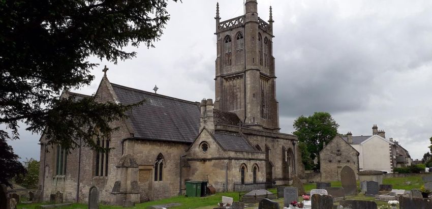
ST. JOHN’S CHURCH, FROME
SOME HISTORY ABOUT FROME
The probable meaning of Frome is a description of the flow of the river; Celtic meaning fair, fine or brisk. The
name was first recorded in 701 when Pope Sergius gave permission to Aldhelm to found a monastery "close
to the river which is called From”.
In about 700AD Aldhelm decided to found a mission to the "heathen or misguided " Celtic Christians in the
middle of Selwood Forest. So in order to be closer to them, the church of St John the Baptist at Frome was
founded. The dedication was probably an allusion to the fact that St John had also preached in the
wilderness.
William of Malmesbury wrote in 1125 that Aldhelm “built a church of stone”. This may be where the present
day Lady Chapel is inside the church. Little is left of the old Saxon church. However during restoration of St
John's church there were revealed apparent foundations of Saxon arcades and many Saxon stones were
discovered in the tower as well as possibly an early Saxon burial. The only authentic Saxon remains are two
sculptured stones built into the wall of the tower and visible from the interior. They are believed to be part of
the cross erected to mark St Aldhelm’s last journey. The stones may have been part of the crosses “where
many persons afflicted with stubborn distempers, by their earnest prayers were restored to health”.
Aldhelm put Frome on the map, and it became a Royal Manor. The Saxon kings had a palace here and
hunted in the Forest of Selwood. King Athelstan held a parliament or Witan in Frome in 934AD and it may
have had a mint.
FACILITIES
Frome has many places to eat and stay. It has many independent cafes, and public loos.
It also has a small museum.
And a prayer to end the day:
May the road rise up to meet you
May the wind be always at your back.
May the sun shine warm upon your face;
The rains fall soft upon your fields
And until we meet again, may God hold you in the palm of His hand
Traditional Gaelic Blessing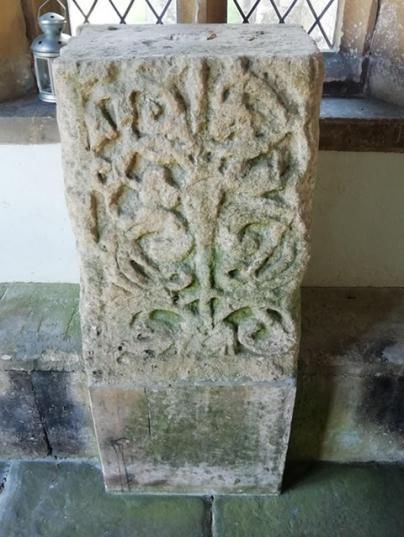
DAY TWO

FROME TO WESTBURY - approx 8 miles

A PILGRIMAGE PRAYER
O Lord God, from whom we come,
in whom we are enfolded,
to whom we shall return.
Bless us in our pilgrimage through life,
with the power of the Father protecting,
with the love of Jesus indwelling,
and the light of the Spirit guiding,
until we come to our ending
in life and love eternal. Amen.

Standing outside the west front of the church, take the steps down to your left passing the unique Via Crucis
on your right and St Aldhelm's well at the bottom.
Turn left down Cheap Street, one of the most complete medieval shopping streets in Europe and with a leat
running down it.
Turn right onto the main road, Bath Street, and walk over the river bridge.
Immediately turn right along Willow Vale following the footpath keeping the River Frome on your right for
about half a mile.

When you reach the A362, turn left and walk past the cemetery on your left, and a supermarket on your right.
Continue straight on and after 2 bridges and approximately 400 yards, turn left along a driveway with two
stone pillars and iron gates; opposite an electricity pylon.

After approximately half a mile, at the gate to Rodden Manor, go straight on through a kissing gate across a
field, through two kissing gates, walk over Rodden Down, across the field, two kissing gates, another field,
and join a tarmac track to Rodden church. The church of All Saints is charmingly set in this peaceful location,
it has been a place of worship since the thirteenth century at least, and was restored in 1640.
There are lovely views here over Rodden Brook.

Return to the tarmac track and turn right just before the church and take the footpath to Lodge Hill.
Go through a kissing gate, across the field, through a gate across the field through 2 gates, across another
field, through two more gates across a small field and onto a lane.

Cross the lane through a gate, across the field, through two more gates, across the field and go past a
treehouse on the left.
Through the gate and field, keeping the hedge on your left, with lovely vistas on your right. Go through a
kissing gate and across the field.

Turn right along the track at the end of the field (there are beautiful hills to your right).
Walk down the slope and into the next field.
Go round the field keeping the hedge to your left then into the left flank of that same large field taking a 90
degree turn.
Continue.
Taking another 90 degree turn at the end of the field. After 100 yards there is a stile on the left.
Go over the stile and across the field.
Walk to the RIGHT of the farm and pond, go through the gate, walk straight ahead (aiming for the middle of
the hedge). .

Walk across the field, through the gate and across the next field bearing slightly right.
Cross the stile and walk across the field bearing left up the hill enjoying the views.
Then walk down the hill over the stile in the far corner of the field and onto the road by the farm house, Spring
Farm.

Turn left along the road and walk for about 400 yards.
When you come to the hamlet of Huntenhull Green, bear right down the track.
At the end of the track, about 50 yards, turn right onto the road and immediately left, cross the stile onto the
footpath.
Walk across the field over the stile and then walk up hill keeping the hedge on your right, over the stile in the
top right hand corner of the field.
Chapmanslade Village is on the ridge to your left as you walk up the field.
Bear right along the edge of the field for 200 yards.
Turn 90° left by the large tree in the field, walk across the field to the kissing gate.
Go through the kissing gate, across the field, down the slope, through the kissing gate, over the footbridge,
through another kissing gate onto the road.

Turn left along the road and come to Dye House Farm, (which maybe muddy in winter).
The road becomes a footpath and goes up the hill through a tunnel of trees emerging at the top onto a road,
Southcroft, leading into Chapmanslade, which has a pub.
At the first T-junction at the green, turn right onto the main road, walk for about 300 yards.
Keep on the pavement or grass verge. After the plant nursery keep on the right hand side of the road and then,
after about 100 yards, take the footpath, crossing the stile.

Follow the footpath across the field, then cross the stile on the right onto the road.
Walk past Thoulstone Farm walking on the grass verge.
When you reach the A 36, cross this extremely busy road very carefully and take the quiet road opposite.
After about 200 yards on the right hand bend, take the footpath going straight ahead.
At the time of walking there were bluebells and primroses lining this wooded path and a green woodpecker
yaffling as we walked along this Drove Road.

After about 1 mile at a footpath junction, turn right, along a main route until you reach a road.
Turn left and immediately left again towards Dilton Marsh. Walk for about 2/3 of a mile. Turn right after a small
settlement at the bottom of a slope, along the footpath under a railway arch onto a road at Thistledown Farm.
Turn left when you join the road after about 100 yards.
(You can follow the road to Saint Mary's Church Old Dilton, which is Grade 1 listed and well worth a very short
detour. The key is held in a nearby house).

Just before the Old Church turn right along a footpath and through a kissing gate.
Go through a kissing gate and the next field, another kissing gate towards the farm, and turn right in front of
the farmhouse. Then walk to the right of the farmhouse with a stream on your right. Cross the footbridge over
the stream, walk through the kissing gate and then walk left up the hill.

At the top of the hill, go through the kissing gate across the field keeping close to the hedge on your right, after
50 yards walk through the kissing gate to your right following the footpath onto the track.
After 200 yards turn left as the track turns 90° right, after the telegraph pole.
After 50 yards turn right, take the footpath along the backs of the houses on your left, with the fields on your
right.
Walk onto the main road at Chalford.
At the end of the footpath, turn right and first left into Wellhead Drove, a quiet road.
After about 3/4 of a mile walk straight on.
At the water treatment works walk past the bollards along the bridleway for approximately 1 mile. At the end
you are rewarded with a view of the Westbury White Horse on the right.

Turn left at the T-junction down the hill into Westbury town, cross Bratton Road.
Walk straight on down Alfred Street, and after about 300 yards, opposite Royston House, there is a footpath
on your left which leads to the churchyard and to Westbury Parish church, All Saints.
Westbury church is built on the site of a Saxon church. It is 14th century.
.

                                ALL SAINTS CHURCH WESTBURY

SOME HISTORY ABOUT WESTBURY

Westbury - the most likely origin of its name is simply because the town is near the western edge of the
county of Wiltshire, the bounds of which have been much the same since the Anglo Saxon period.

The bury part of its name indicates a hill or a fortified town. In Wiltshire this often indicates an Iron Age or
Bronze Age hill fort, and such a site can be found immediately above the Westbury White Horse. It is
sometimes claimed locally that the White Horse was first cut into the chalkface as long ago as the year 878, to
commemorate the victory of Alfred the Great over the Danes in the battle of Edandun, possibly at nearby
Edington, However, scholars believe it to be an invention of the late 18th century. The form of the current
White Horse dates from 1778 when it was restored.

FACILITIES

Westbury has many shops, pubs, cafes, bakery, Post Office, public loos etc

And a prayer to end the day:

God our Father
This day is done
We ask you and Jesus Christ, your Son
That with the Spirit, our welcome guest,
You guard our sleep
And bless our rest
Amen
DAY THREE WESTBURY TO BRADFORD ON AVON - approx 7 miles A PILGRIMAGE PRAYER O Lord God, from whom we come, in whom we are enfolded, to whom we shall return. Bless us in our pilgrimage through life, with the power of the Father protecting, with the love of Jesus indwelling, and the light of the Spirit guiding, until we come to our ending in life and love eternal. Amen. As you emerge from the south door of Westbury Parish Church (just off the Market Place), turn right. After about 20 yards turn left after the Parish Hall on your left, down Church Lane, and pass Church Villa on your right. After 20 yards you will come into Edward Street, turn left down It and passing the library on your left, and bearing right through the modern precinct in the High Street. At the T-junction with Haynes Road, turn right and cross the road at the pedestrian crossing continuing along Haynes Road. After about 50 yards, at the roundabout turn left and take the footpath immediately to the left of the Methodist Church on the roundabout, signposted Grassacres. Walk past Grassacres playpark on the right, at the end of the footpath turn left and immediately right, to the left of house number 20 along another footpath. At a T junction after about 100 yards, turn left. After approximately 200 yards, turn right along Springfield Road, then after about 100 yards at a T-junction turn right across a zebra crossing, then after 50 yards turn left along Penleigh Road. After about 50 yards cross Redlands Lane, go straight onto a tarmac footpath. Cross Timor Road, and shortly afterwards take the right fork, by a litter bin, continuing along the tarmac footpath. Cross Hackney Way and continue straight on along the footpath. After approximately 150 yards, cross the main road, straight onto a track through open fields. After 250 yards there is a gate slightly to the left at 11 o'clock, while the main track leads straight onto the farm. Go through the gate to the left which says "beware of the dogs" and also " Bridleway Access Only" . Then go through the second gate beside two houses, and then a third gate onto a road, under a railway bridge. After about 50 yards there is a T-junction with a road, turn right along the road, which is also the NATIONAL CYCLING NETWORK Route 254. walk across a railway bridge, the road goes round to the left. About 50 yards after the railway bridge take the footpath to the right, across a stile and walk across the field. Cross another stile, then over the railway tracks carefully, go over the stile, keep the hedge on your right and walk on the edge of the field for about 40 yards, cross the stile on your right. Keep to the edge of the field, turn left in the next field keeping the hedge on the left. After about 200 yards in the corner of the field, go over the stile, which is easily missed, into the next field. Go straight across the field, crops allowing, or follow the hedge to the right. Head towards the blue buildings and meet a road at the top right hand corner of the field, there is a gate. Turn right onto the road. After about 10 yards on the road turn left onto the footpath and follow the fence to your right. Cross two stiles. Walk over the next field keeping the fence on your right. After about 50 yards at a right angle in the corner of the field cross over the stile, over the footbridge, across the next field keeping the fence on your right, until the fence ends. Then head for the furthest right hand corner of the field and the large industrial building on the right. Go through the gate.
Keep on the footpath with a stream on your right.
Cross the stile onto the road.
Cross over the road.
Go over the stile and turn left keeping the road on your left.
After about 150 yards walk into the corner of the field, and cross the stream in front of you, cross the stile.
Go straight ahead with the pylon to your left, through a large field.
Walk through a large gap in the hedge into the next field at about 2 o'clock.
Cross over 2 stiles and follow the hedge on your right in the next field.
After approximately 100 yards turn right, go over two stiles into the next field.
Head across the field at 11 o'clock to a stile to the left of a house, go over the stile.
Walk straight on along the footpath to the side of the house onto a track, walk straight on along the track.

When you reach the main Bradley Road cross it, and turn left.
After about 50 yards turn right along the bridleway.
After about 200 yards at a junction take the right fork at 2 o'clock, along a grassy track with a solar farm on
your left.
After about quarter of a mile take a kissing gate on your left, go straight ahead through the solar farm aiming
for the white cottage.
The footpath goes to the left of the cottage through a hedge gap towards housing.
There is a bridge over the stream into the next field, follow the footpath at 11 o'clock.

Take the kissing gate and go straight on with the housing on your left. take a left turn into housing. This is
Southwick village.
Take the first right, and after 20 yards take the lane past the garages after house number 27. After 30 yards
turn right when you reach Fleur de Lys Road.
At the T junction with the main road, turn left and immediately right down the lane signposted Southwick
allotments.
There is a pub a little bit further along the main road called The Farmhouse that does Bed and Breakfast and
food. The village has shops and cafes. The Country Park has a cafe

When you reach the allotment carpark, follow the track up to the entrance of Southwick Country Park.
Take the kissing gate and the footpath at 1 o'clock (not the path which is straight on).
Continue on the footpath straight ahead, ignoring other routes.
In the next field keep close to the wood on your left. At the end of the wood, take the footpath to the right
through the hedge onto the path and turn left.
After 200 yards, where the path divides into two around an island of grass, take the right fork, go straight
ahead, over the stile leaving Southwick Country Park.

Cross the field in the direction of 11 o' clock, over two stiles, across a field to the stile in the left corner of the
field, climb over this stile, through the gate, through the barrier, and cross the field keeping close to the left
fence.
Cross the stile in the left corner of the field.

Walk over the field to the left corner, cross the footbridge and then walk over the next field in the direction of
2 o'clock, Wingfield Church is to your right.
After 200 yards cross the stile on your right into the next field and cross this field in the direction of 10 o'clock.
Take the stile over the gate and cross the field at 1 o'clock. (Wingfield House is ahead of you.)
After 20 yards take the footpath into the next field.
Cross the field towards the church and pub.
Take the stile on the right into the churchyard and Wingfield Church.
The church seems to be included within the bounds of the land that was given with the manor of Bradford to
Shaftesbury Abbey in 1001. The name Wingfield may be derived from the field of a Saxon called something
like Wine. There is a reference in a charter of King Edgar in 954 and places in Wingfield appear to be within
the manor of Bradford that is granted by Aethelred to Shaftesbury Abbey in 1001.The charming church of St
Mary’s, is 15th century.

Standing at the South door of the church facing south, turn right and leave the churchyard down the gravel
drive, with the wall on the right, onto the road.
Turn right through the car park past the pumping station on the right over stile, cross the field ( meeting the
BRADFORD ON AVON WALKING WHEEL FOOTPATH ) keeping the hedge on the right, to the right corner
of the field.
Cross the stile, and walk along the track/drive.
Go over the stile, cross the main road and walk along the quiet road.

After 200 yards there is a large house on the left, the road forks.
It looks as if you are on private land.
Beside the gate with number 12 on it, go over the stile to the right of the stone house. Keep to the left of this
field.
After 20 yards, cross the stile on the left, and turn right, follow the fence until you come to a stile and cross it.
Follow the fence on the right, after 100 yards you are joined by a track from the right, keep following this track
forward, keeping the trees on your right.
Go through a gate in the right-hand corner of the field into the next field.
Follow the track around the edge of the field keeping the hedge to your left.
Follow the track through the gate into the next field and stay on the track keeping the hedge to your left. We
saw a buzzard here.
Then go over the stile onto the road.
Turn left to walk along the road, after 300 yards, just after a right and then left bend in the road, take a
bridleway off to the right.
After 200 yards turn left over a footbridge, and follow a footpath which becomes a lane.

[You may like to divert from St Aldhelm’s Way to visit Bishopstrow to visit St Aldhelm’s Church and the site of
a story about St Aldhelm. He was renounced for his long but inspirational sermons. When preaching here, he
stuck his staff into the ground whilst preaching, which then sprouted roots and leaves and grew into a healthy
Ash tree. That place became known as Bishops Tree, now Bishopstrow.
The church is 14th century, restored. The site may have been in use since the eighth century.]

The lane after a while gives onto a Business Park, keep straight on.
There is a large supermarket with a café and a takeaway business on your left.
These are the outskirts of Bradford on Avon.
At the roundabout, turn right along Spencer's Orchard, cross over the road at the Kennet and Avon canal.
At the end of the bridge, turn left down the canal tow path, then turn right along the canal.
Walk past the public loos plus tearooms and gardens on the right, keeping the canal on your left, until you
reach the road bridge.
Turn right and cross the road.
After 20 yards, turn left at the Lock Inn Cafe and continue to walk alongside the canal.

Barton Farm Country Park, Historic Barton Farm and 14th Century Tithe Barn (plus tea room) are on your
right.
After about 300 yards turn right (marked Town Centre, just by the Tithe Barn) down some steps, keep walking
straight ahead into Barton Farm Country Park.
Turn right at a T junction near the river.
After 10 yards turn left over the 14th century packhorse bridge, (Barton bridge), and go past the rowing and
canoe club.
After the bridge take the right fork by the canoe club, go over the stile and then the railway with care.

Walk up the steps through the gate, along the lane, which becomes a very quiet road, Barton Orchard, which
was an ancient packhorse way from Barton Grange farm to Winsley Village and Bath.
Some of these houses in Barton Orchard were weavers cottages.
There was a communal wash house fed by Ladywell spring. Number three is an 18th-century clothiers house.
At the end of Barton Orchard, turn right past the Chantry, down the lane with a handrail.
The lane opens out and Holy Trinity Church is straight ahead of you.
The little Saxon church of Saint Lawrence is 50 yards on, on your left. It is supposed to be one of the most
complete Saxon buildings in existence.
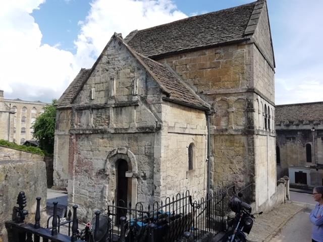
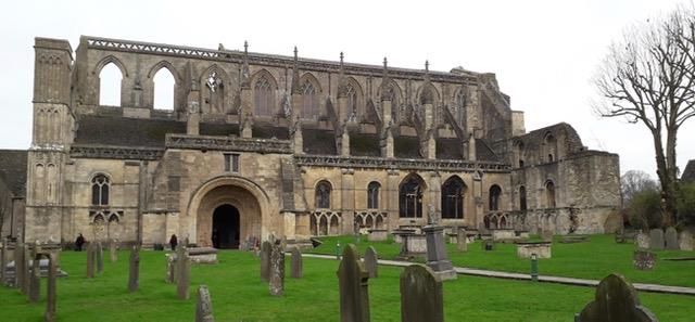
ST LAWRENCE'S CHURCH, BRADFORD ON AVON

SOME HISTORY ABOUT BRADFORD ON AVON

The name means the broad ford on the Avon. The First mention of the place is in the Anglo-Saxon Chronicle
for AD652 which refers to King Ceanwalh of Wessex fighting a battle here. Until England became unified,
Bradford was right on the frontier between Wessex and Mercia.

By the end of the seventh century Aldhelm of Malmesbury is reputed to have founded a monastery at
Bradford. It is thought that such a Saxon minster church would have been replaced by the present Holy Trinity
parish church in the 12th century. Work carried out at the church in 2016 found burials under the Norman
walls and two were carbon dated as ninth and 10th century. In 955 King Eadred granted Bradford to the Priory
in Winchester and four years later the King held a great council meeting in Bradford. This suggests that
Bradford was part of the Royal Estates. In 1001 king Ethelred the Second granted Bradford to the Abbey of
Shaftesbury in Dorset.

The 12th century historian William of Malmesbury reports that St Laurence’s Church was standing in the
1120’s, But he thought it dated back to the time of Aldhelm who died in 709. It is a characteristic Anglo-Saxon
building, tall and narrow with small windows. Part of a cross shaft dated to the ninth century is built into the
display above the altar. The richness of its decoration is rare perhaps suggesting that it may have been
designed partly for the relics of Ethelred’s brother King Edward the Martyr, which were housed with the nuns
at Shaftesbury. Sometime later the church was lost amidst other buildings including a schoolmaster’s house.
It was used as an ossuary and a free school for boys. It only came to notice again in the 19th century. It is still
used as a place of worship by the congregation of Holy Trinity Church across the road.

Holy Trinity Church itself dates from the 12th century. It is built on the site of a Saxon Minster church, possibly
founded by Aldhelm and mentioned by William of Malmesbury,

(The chapel of St Mary Tory is also in the care of the Saxon Church Trust. It is up the hill from the St
Laurence’s church. It was described by Aubrey as “ the finest hermitage I have seen in England”, you may like
to call in to visit this dear quiet chapel ).

FACILITIES

There are many cafes, pubs and places to stay in Bradford on Avon.
It has a small museum

And a prayer entitled Journeying to end the day:

The Lord be with your going
Bless you with your coming
The Presence be with your travels
Bless the road as it unravels.
God go with thee on the road
Go thou out in the power of God
God go with thee on thy way
God protect thee from the fray
God keep thy body and thy soul
God watch thee as the years roll.
God keep you safe when the cliffs are sheer
God keep you safe when the night is drear
God keep you safe on the path you tread
God keep you and be with you at your head.

David Adam

DAY FOUR

BRADFORD ON AVON TO BATH. approx 7 miles

A PILGRIMAGE PRAYER
O Lord God, from whom we come,
in whom we are enfolded,
to whom we shall return.
Bless us in our pilgrimage through life,
with the power of the Father protecting,
with the love of Jesus indwelling,
and the light of the Spirit guiding,
until we come to our ending
in life and love eternal. Amen.

Come out of the Saxon church, facing Holy Trinity Church and turn right along the road, retracing your steps
up Church Lane, turning left alone Barton Orchard as before.
Go down the slope to the railway line, through the gate.

Cross the train tracks with care, go through the gate/stile back into Barton Farm Country Park, cross the River
Avon. After the packhorse bridge turn right along the path, walking with the river on your right.
After half a mile take the left tarmac path, joining NATIONAL CYCLE NETWORK 4, which leads up to the
Kennet and Avon Canal.

Go through Avoncliff East, past moored boats.
After about one and a half miles there is a pub on the right at the Avoncliff Aqueduct but just BEFORE the
aqueduct, turn right and immediately left UNDER the aqueduct.
Go straight on, then after 25 yards, turn left past the tea gardens on your right, and opposite there, turn left,
and go over the aqueduct keeping the canal on your RIGHT.
NB. This is important, you need to be on this side of the canal to access the tow path on the NATIONAL
CYCLE NETWORK 4.
Continue walking along the towpath NCN 4 between the canal and the River Avon. This is a NATIONAL
WATERWAY WALK
(The Kennet and Avon Canal was built as a commercial transport route between 1795 and 1810, providing
travel between London and Bath and via the River Avon on to Bristol. The Avoncliff Aquaduct was built in
1801).
After 3 miles you come to the Dundas Aqueduct, ( built in 1810 ) walk over it, crossing the river Avon and
railway. The GREATER AVON WALKWAY starts here.
This is also the start of the NATIONAL CYCLE NETWORK ROUTE 24 from Dundas to Frome, (The Colliers
Way and the Somerset Coal Canal).

Follow the signs to Claverton and Bath i.e. turn right after Dundas basin and keep The Kennet and Avon
Canal on your right.
There is a café at the canal visitors centre.
You are now on the LIMESTONE LINK FOOTPATH.
Almost immediately cross the canal on the Horse Bridge, turn left keeping the canal on your left you are on
the NCN 4 and the railway and river are on your left.
Walk past the Claverton moorings.
After 1 1/4 Miles turn off the towpath at bridge number 179.
Turn left on the road over the bridge signposted Ralph Allen mausoleum and Saint Mary's Church Claverton.
( People do paddle at their own risk in the river at Warleigh Weir to your right )

Walk up the hill and after 50 yards go through the stile on the right and walk across the field, through the
kissing gate and immediately right.
Cross the main A36 road carefully, through a kissing gate to the left to a bus shelter at approximately 10
o'clock.

Saint Mary's Church, Claverton and Ralph Allen's mausoleum are after 50 yards on your right.
Claverton Village is Saxon in origin, and is mentioned in the Domesday book as Clafertone, Possibly from the
Saxon Word for clover, signifying the mini meadows associated with the village, or from another old English
word for water lilies. Saxon remains have been found at various sites in the village.

200 yards after the church there is a T-junction, turn right signposted Claverton Down, go up the hill, along a
quiet road with no pavement. Take care.
Near the top of the hill is the American Museum and Gardens. If you pay to go in there is a café here.

About 150 yards past the museum entrance turn right off the road into National Trust woodland.
Walk straight on.
After 100 yards follow the signs to Bushy Norwood and the BATH SKYLINE WALK at a right fork through a
meadow and through a gate in the left corner of a field.
Go straight across the next meadow keeping close to the hedge on your right.
Go through a kissing gate and after 30 yards, take the path on your left going upwards.
This path leads out to Bath golf course, follow the edge of the golf course to the left.
After 300 yards walk straight over a track.
200 yards after this, at a signpost to North Road, take a footpath right, keeping watch for golf balls.

Follow the two posts straight ahead, then turn left after a row of trees.
Walk straight ahead, heading for a post in a gap in the trees.
There is a track straight ahead, follow the track down the hill.
After 100 yards you will find Sham Castle on the left, which was built as a folly in 1762.
There is a café at the golf club on your right.
Turn left just after the castle and within 20 yards turn right through the wood.
But stop first to admire the view of Bath from the well-placed seat.
After 100 yards cross the road through a kissing gate, down the field keeping the fence to your left. Walk
down the steps to North Road, and turn right down this road.

After 100 yards take the footpath left down the steps walking into the view of Bath.
At the end of the road cross over Cleveland walk to Sham Castle Lane.
At the bottom of this lane turn sharp right where there is a T-junction the Kennet and Avon Canal is to your
left.
Turn left when you reach another T-junction with Sydney Road, cross over the railway and go past the
Holborn Museum on your right (which has a cafe) and cross Sydney Road.

Then cross the main road Darlington Street at the pedestrian crossing and walk down Great Pultney Street
over the bridge.
Great Pultney Street becomes Bridge Street.
Continue to the T-junction, passing Victoria Art Gallery on your left.
Turn left into the High Street.
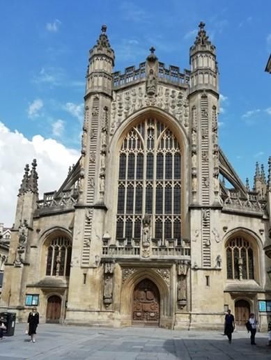
Bath Abbey, your destination, is in front of you, and is the start of the COTSWOLD WAY.
This is where King Edgar, first king of all England, was crowned in the Saxon Abbey.
BATH ABBEY
SOME HISTORY ABOUT BATH
Much has been written about the Roman Spa at Bath, In 675AD Osric, a local king, gave lands near Bath to
the Abbess Berta to found a Saxon convent in Bath. And in 757AD land was granted to the brothers of the
monastery of Saint Peter in Bath to found a monastery. In 781AD King Offer of Mercia claimed ownership of
the abbey at Bath. It becomes increasingly important, a Witan ( Parliament ) is held here in 901, it had a
Saxon mint, and in 973AD Edgar is crowned King of all England in the Saxon Abbey.
St Alphage is appointed head of the monastery at Bath in 980AD and insists that the monks at the abbey live
more strictly. He introduces the rules written in the sixth century by Saint Benedict of Nursia. In 1088AD the
Bishop of Wells is given the ministry at Bath. He orders the building of a large new cathedral which replaces
the Saxon Abbey. It is possible that the Saxon church is located under the present church.
Some Saxon cross fragments are held by Bath Abbey Archive. It is possible that the Cross Baths were named
after the Saxon cross that was erected for Aldhelm.
Bath Abbey's present magnificent building was founded in 1499, ruined after the dissolution of the
monasteries in 1539 and completed in 1611. It is a building a great light and beauty with its unique ladder of
angels on the west front.
Bath was named after its Roman built baths.
FACILITIES
Bath is full of cafes, pubs, supermarkets, places to stay and museums. It has public loos.And a prayer to end the day: Circle of love Open my heart Circle of wisdom Enlighten my mind Circle of trust Protect my path Circle of healing Grant me new life Amen DAY 5 BATH TO COLERNE. - approx 7 miles A PILGRIMAGE PRAYER O Lord God, from whom we come, in whom we are enfolded, to whom we shall return. Bless us in our pilgrimage through life, with the power of the Father protecting, with the love of Jesus indwelling, and the light of the Spirit guiding, until we come to our ending in life and love eternal. Amen. Coming out of Bath Abbey turn right and then immediately right again into Abbey Churchyard along the High Street, cross the High Street at the pedestrian lights after 30 yards at the Guildhall. Retracing your steps of yesterday turn right along Bridge Street and after 20 yards walk past Victoria Art Gallery, straight over Pulteney Bridge into Argyll Street which becomes Great Pulteney Street, to the Holborn Museum at the far end. Go right around the museum into Sydney Place and take the left turn into Sydney Gardens, after 20 yards keep on the tarmac path and head to the 41st bridge. Go over the railway bridge and take the right fork up the slope until you reach the Kennet and Avon canal. Go through a gate on your right at the canal and turn left along the canal, walk along with the canal on your right and railway to your left for about a mile and a half. At Bathampton at the George pub turn left down steps off the canal and walk to join the road past the church on your right. Walk past the George pub and St Nicholas Church over the railway and road bridges. The church has its origins in the thirteenth century and was altered during the fifteenth century. Walk along the road carefully for about 300 yards, then cross the road and through a gate on your right signposted Batheaston half a mile. Follow the gravel track through Bathampton Meadows Riverside following the River Avon on your left over a bridge over the river into the car park with a public loos and a water drinking fountain, emerging onto the main London Road. There you will find a convenience store, pub, post office, pharmacy and café. Cross the main road at the pedestrian crossing. Turn right along the main road.After 10 yards at the mini roundabout take the third exit called Bannerdown Road, signposted Colerne, and walk up the hill. Walk straight on at the mini roundabout (after a third of a mile), along the lane with care, there are no pavements, for about quarter of a mile. Take a right turn down a country lane, Shockerwick Lane, signposted to a vineyard. After 3/4 of a mile take the right fork down the hill for 3/4 of a mile. Just before the By Brook turn left and immediately right along the footpath, through the gate and kissing gate, Shockerwick House is on your left, walk along with the brook on your right, this is known as the Bybrook River Valley.
Walk through kissing gate and through a gate across the field, through another gate and head for the brook
following the stream.
Walk through the next field with the brook on your right. About halfway along the field look for a gate on the
right go through that gate and walk straight across the field over the stile and onto the road.
Cross the road and go straight ahead down the public footpath, past cottages on your right and a delightful
smallholding.
Walk under the railway through the gate over the stile, and straight on over the meadow heading for Box
church with a spire.
Through a kissing gate and cross the field at 10 o'clock.

( If you would like to visit Box Church which is Grade 1 listed, then turn sharp right at the copse and follow the
footpath to the church spire, crossing the stream and up the footpath to the church. It has possible Saxon
origins. There is some evidence of Aldhelm working in this area and there was a Saxon church constructed
here with a Norman church later replacing it ).

Keeping the copse on your left, walk through a kissing gate with the stream on your right and the railway on
your left, walk through the kissing gate onto the road.
Walk left under the railway bridge, with the stream on your right.
After one bridge and before the second bridge, about 100 yards after the railway bridge, take the right fork
down the footpath at about 2 o clock, the stream is now on your left.
Take the footbridge over the stream, turn right, follow the footpath round the edge of the field.
Walk through a kissing gate and follow the MACMILLAN WAY for 1 mile, through a kissing gate onto a lane.
Turn right down the lane off the MACMILLAN WAY.
After 50 yards turn left at the junction and follow the quiet lane to Colerne up the hill, about a mile and a
quarter.
(Pevsner writes "Colerne is a hill village. Approaching it from the south one may picture oneself in the Tuscan
hills”)

You will see a view of Colerne Church above the trees near the top of the hill.
Walk straight on at the crossroads. Shortly after a left bend in the road with a village green on the right, there
is a gate on the right with a label stating " Consecrated Ground ", this leads to Colerne Church churchyard.
There are fragments of a Saxon stone cross associated with St Aldhelms last journey to Malmesbury in 709.
This may well have been a resting place for Aldhelm.

                               ST. JOHN THE BAPTIST CHURCH, COLERNE

SOME HISTORY ABOUT COLERNE

Colerne could mean dwelling on the peak, a house where charcoal was made, cold dwelling ( from the Anglo
Saxon word Cald ) or holly tree.
There is known to have been a Saxon settlement in Colerne, but no mention of a church. However within the
present church building are two large fragments of “one of the best ninth century crosses
in the West Country”. The motifs are wildly inter-twined dragons. These are associated with Aldhelm’s last journey and were found in the wall of the church when it was restored in 1877. FACILITIES Colerne has 2 pubs, a convenience store and public loos And a prayer to end the day: Christ be with me, Christ be in me, Christ behind me, Christ before me, Christ beside me, Christ to win me, Christ to comfort me and restore me, Christ beneath me, Christ above me, Christ in the hearts of all that love me, Christ in the mouth of friend and stranger. DAY 6 COLERNE TO LITTLETON DREW - approx 7 miles A PILGRIMAGE PRAYER O Lord God, from whom we come, in whom we are enfolded, to whom we shall return. Bless us in our pilgrimage through life, with the power of the Father protecting, with the love of Jesus indwelling, and the light of the Spirit guiding, until we come to our ending in life and love eternal. Amen. Coming out of the West door of Colerne church turn left through the churchyard, exiting the way you came in, down the steps onto the road on the south side of the church. Turn left down the hill with the open green space and old well on your left, keep walking down the hill. After 200 yards turn left (signposted Widdenham) for about half a mile. Walk past the farm on your left. As the road takes a dive right and sharp right, go through the kissing gate and walk down to the river across the field. Go through the gate, cross the field and through the edge of the copse ( Monks Wood ), a Woodland Trust wood, part of Colerne Park. Walk over a footbridge across the stream, keep walking on the path for 200 yards. When you reach a track, keep the barbed wire fence on your left, ignore the track to the right and gate to left, walk along footpath for 300 yards. Walk through the gate onto the footpath ( Weavern Lane), turn left along the track which will take you through a wood. The track becomes a shady lane, walk along it. After 100 yards join the road and walk straight along the road into the hamlet of Slaughterford along the road past By Brook. Take the raised pavement on the right up to the church. There are ancient stones in St Nicholas churchyard and possible runes in the porch. It stands in a field. (The church was partially destroyed by Cromwell’s troops during the Civil War.) You may like to visit this lovely rural church. During Saxon times there were apparently many mills along the By Brook. Over the years corn, cloth fulling and paper have been milled here.
As you come out of the church yard gate, turn left and walk over the field to a stile just to the left of the gate
beside a barn.
Cross over the stile and walk down the steps onto the road and walk through the metal gate opposite.
Cross the field heading for the telegraph pole in the middle of the field.
Go through the gate and take the footpath along the edge of the copse.
After 50 yards keep on the higher footpath heading towards the lake.

At the lake, turn right and take the footbridge over the lake, and then walk along the river, over the stile and
onto the road, merging with the PALLADIAN WAY.
Turn right towards Ford Village, where there is a pub.
Turn left at the White Hart pub in Ford which is on the right and easily missed.
Take the footpath up the steps and come out opposite Ford Old Arts and Crafts church, which is now a home.

Cross the main A 420 Road carefully, turn right and walk 200 yards along the main road, and take the second
road on the left.
After 200 yards, at the brow of the hill, the road bends to the left.
Take the kissing gate to the right and cross the field on the footpath.
Go through the kissing gate, and turn right.
After 100 yards go through the gate into a copse, still on the MACMILLAN WAY, passing a mill on your right,
go over the bridge over the brook.
You will then reach a hamlet, turn left at a crossroads and immediately left at the postbox, follow the track into
the wood, over two stiles, in and out of woodland.
Go through a kissing gate, over the footbridge onto a road, turn right and into Castle Combe.

Walk up the High Street
From the Domesday Book there is evidence that the village was settled in Saxon times. There were three
mills, a castle and a market. It has a 14th century market cross.
There are lots of tea shops, pubs, cafes and places to stay here.
On the left is the church of Saint Andrew, which was originally founded in the 13th century.

Continue walking up the High Street, past the Castle Inn on the right, under the archway, and follow the road.
After a sharp right turn in the road, go past Gardeners House on the right, take the track straight ahead, go
under the little stone arch, up the steps, and through a gate, turn left, keep the golf course on your right,
keeping an eye out for golf balls.

Join a tarmac path. After 20 yards turn left over a little bridge.
Continue on the tarmac path through the golf course.
After 200 yards and just before another little bridge bear left at a public footpath sign in the grass. Walk
through the woods beside By Brook.
Go through a kissing gate onto a road ( past Nettleton Mill house on the right) for about two thirds of a mile.
At the road junction go straight on, walking on the road for 200 yards.

As the road curves to the left, take the footpath into the field at right angles to the road, keeping the hedge on
your right.
In the next field keep the hedge on your left, noting Lugbury Longbarrow on your right.
In the corner of the field, walk into the next field with the hedge on your left.
Walk through the gate and down the field and through the gate near the barn.
Walk past the barn and over the brook, Goulters Mill Farm on the left with an old barn and out buildings on
your right.
Walk up the drive ( not the track to the left) along rough tarmac until you reach the B4039 road which has a
signpost to Littleton Drew 1 mile.
And walk along the road for 1 mile into the village, under the M4 bridge. Littelton Drew church is on the left.
You can also read